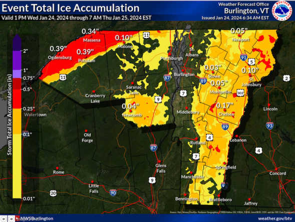
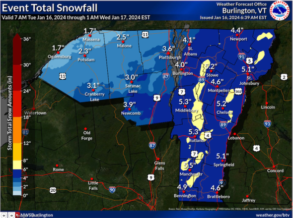
Wednesday, January 31, 2024

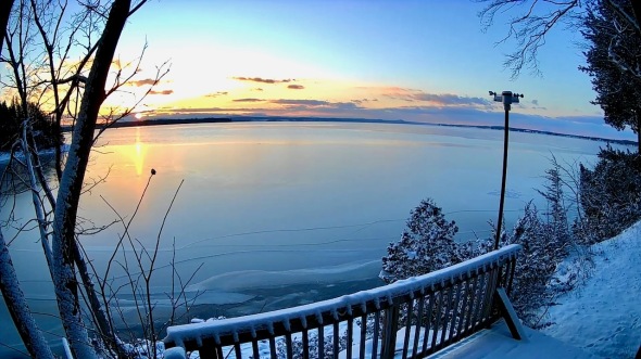
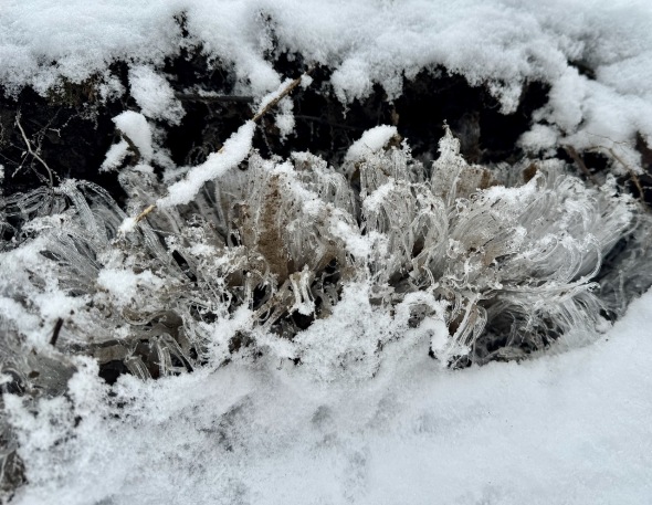 Delicate needle ice along the trail at CHNSA
Morning Observation:
This morning in Huntington at 8:00AM it’s currently 29 degrees under cloudy skies. Winds are calm. Th is 90%, dewpoint 27, barometric pressure 30.10”. We have 5” of snow at the stake. Yesterday’s high was 30, and yesterday’s low was 25. The overnight low got down to 29.
This morning in North Hero it’s currently 30 degrees under cloudy skies. Winds are calm. Relative humidity is 92%, dewpoint 28, barometric pressure 30.15”. Yesterday’s high was 27, and yesterday’s low was 20. The overnight low got down to 24.
Forecast Discussion:
High pressure slipping to our east today will bring in a light southerly airflow allowing temperatures to warm into the mid 30s today under cloudy skies. A weak, moisture-starved clipper low will skirt to our north during the day on Thursday bringing some chances of precipitation. We’ll likely see snow at the onset Thursday mid-morning, mixing with or changing over to rain midday as temperatures rise into the upper 30s, then light snow overnight into Friday morning. Impacts are expected to be minimal if anything with highest precipitation amounts expected over northern west-facing mountains and near the international border. An extended period of dry and seasonable weather is expected heading into the weekend with maybe even some sunshine returning by Sunday into next week.
3-Day Forecast:
We’ll see cloudy skies today with a high near 35 and south winds 5-10 mph. Tonight should be cloudy with a low around 29 and south winds 8-15 mph.
Thursday should be cloudy with a 40% chance of snow showers after 10:00AM, mixing with rain after 1:0PM. Highs will be near 37 with southwest winds 8-14 mph. Little or no snow accumulation is expected. Thursday night should be cloudy with a 50% chance of snow showers. Lows will be around 25 with calm winds becoming northwesterly around 5 mph after midnight. New snow accumulations of less than 0.50″ are possible.
Friday should be cloudy with a 50% chance of snow showers. Highs will be near 29 with north winds 9-13 mph. New snow accumulations of less than 0.50″ are possible. Friday night should be mostly cloudy with a 30% chance of snow showers. Lows will be around 14 with north winds 8-11 mph.
Almanac:
Last year on this date in Huntington we had a high of 21 and a low of 2. We picked up 3.2″ of new snow and had 10″ at the stake.
Last year in North Hero we had a high of 24 and a low of 10. We picked up 1″ of new snow and had 7″ at the stake.
Burlington averages for this date are a low of 12 and a high of 29.
The record low was -20 in 198.
The record high was 56 in 2013 (we had a high of 55 in Huntington).
The Lake Champlain lake level in Burlington is 97.72′.
The water temperature is 37˚.
Last year’s lake level was at 96.69′.
The Mt. Mansfield snow stake depth is 48″.
The average depth for this date is 51″.
Mt. Washington Summit Conditions
Current Temperature: 17˚
Winds are out of the NW at 22 mph
24 hr Precipitation: 0
Visibility: around 70 miles
Sky Notes:
Sunrise: 7:11AM
Sunset: 4:59PM
Length of day: 9:47:50
Today will be 2:27 longer than yesterday.
The Moon is waning gibbous, 19.8 days old with 74% illumination.
Moonrise: 11:02PM
Moonset: 9:43AM
About Today’s Photo:
I came across this needle ice while skiing up at Camel’s Hump Nordic yesterday morning. Needle ice forms when damp, slightly-warmer-than-freezing soils are exposed to cold air. The moisture, instead of being absorbed by the soil, is drawn upward through capillary action to create elongated ice crystals. This is some of the most delicate needle ice I’ve seen in recent years . Lovely!
iPhone 15 Pro
Tuesday, January 30, 2024
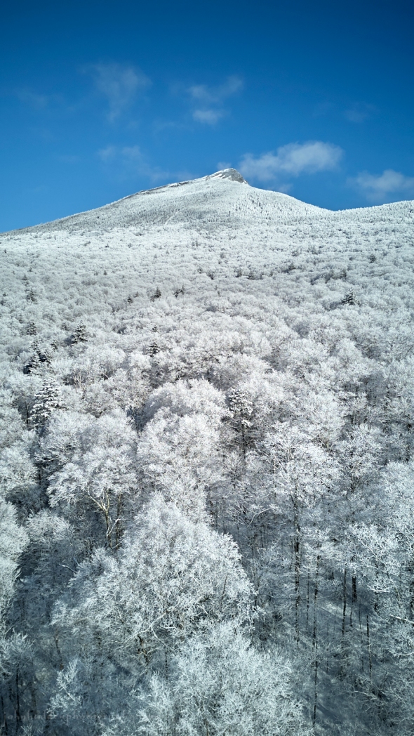 Looking over rime-crusted hardwoods to the Camel’s Hump summit
Morning Observation:
This morning in Huntington at 7:20AM it’s currently 25 degrees under cloudy skies. Winds are calm. Relative humidity is 84%, dewpoint 21, barometric pressure 30.22”. We have 5.25” of snow at the stake. Yesterday’s high was 32, and yesterday’s low was 26. The overnight low got down to 25.
This morning in North Hero it’s currently 21 degrees under cloudy skies. Winds are calm. Relative humidity is 88%, dewpoint 18, barometric pressure 30.30”. Bare ground at the stake. Yesterday’s high was 32, and yesterday’s low was 27. The overnight low got down to 21.
Forecast Discussion:
High pressure cresting over the region today will deliver dry and seasonable conditions with highs near 30 under mostly cloudy skies. Winds will turn into the south later tonight allowing for warmer air to move into the region with highs on Wednesday expected to be in the mid 30s. A clipper type low will pass to our north on Thursday bringing chances for precipitation. With highs expected to top out in the mid to upper 30s, we’ll likely see some snow by late morning, mixing with or changing over to rain by the afternoon, then back to snow in the evening. Then system doesn’t have a lot of moisture to work with, but favored western upslope areas may squeeze and inch or so of snow out of it by Friday morning. High pressure is expected to build back in to the region later on Friday with seasonable temperatures and maybe even some sun expected for the upcoming weekend.
3-Day Forecast:
We’ll see mostly cloudy skies today with a high near 30 and south winds around 6 mph in the morning. Tonight should be mostly cloudy with a low around 21 and south winds around 7 mph.
Wednesday should be mostly cloudy with a high near 35 and south winds 6-8 mph. Wednesday night should be mostly cloudy with a 30% chance of snow showers late. Lows will be around 29 with south winds around 8 mph.
Thursday should be cloudy with snow showers likely before 11:00AM, then rain and snow showers likely. Highs will be near 37 with south winds 3-7 mph. Chance of precipitation is 60% with new snow accumulations of less than 0.50″ possible. Thursday night should be cloudy with scattered snow showers. Lows will be around 25 with calm wind becoming northwesterly around 5 mph after midnight. Chance of precipitation is 40%.
Almanac:
Last year on this date in Huntington we had a high of 23 and a low of 12. We picked up 0.6″ of new snow and had 7″ at the stake.
Last year in North Hero we had a high of 23 and a low of 17. We picked up 1.5″ of new snow and had 7″ at the stake.
Burlington averages for this date are a low of 12 and a low of 29 (up 1˚!)
The record low was -20 in 1948.
The record high was 57 in 2013 (we had a high of 59 in Huntington).
The Lake Champlain lake level in Burlington is 97.78′.
The water temperature is 37˚.
Last year’s lake level was at 96.75′.
The Mt. Mansfield snow stake depth is 48″.
The average depth for this date is 50″.
Mt. Washington Summit Conditions
Current Temperature: 11˚
Winds are calm
24 hr Precipitation: 0
Visibility: over 100 miles under clear sky and undercast (it’s lovely up there!)
Sky Notes:
Sunrise: 7:12AM
Sunset: 4:58PM
Length of day: 9:45:23
Today will be 2:25 longer than yesterday.
The Moon is waning gibbous, 19 days old with 82% illumination.
Moonrise: 9:59PM
Moonset: 9:27AM
About Today’s Photo:
The summit of Camel’s Hump rises above the rime and snow crusted hardwoods in the aerial view from above the Burrow’s Trail parking lot.
DJI Mini 3 drone, ISO 100, f/1.7, 1/2000″ exposure.
Monday, January 29, 2024

 Looking down at Fargo Brook
Morning Observation:
This morning in Huntington at 7:30AM it’s currently 29 degrees under cloudy skies. Winds are calm. Relative humidity is 94%, dewpoint 28, barometric pressure 29.85”. We picked up 0.60” of new snow in the past 24hrs with a bit of freezing rain crust on top this morning. We have 5.5” at the stake. Yesterday’s high was 38, and yesterday’s low was 31. The overnight low got down to 29.
This morning in North Hero it’s currently 31 degrees under cloudy skies. Winds are calm. Relative humidity is 92%, dewpoint 29, barometric pressure 29.94”. No snow. Yesterday’s high was 40, and yesterday’s low was 31. The overnight low got down to 31.
Forecast Discussion:
There has been a bit of freezing drizzle falling here in Huntington and other areas of Chittenden County this morning so be aware out on the roads. We’ll see some slight chances of snow through midday, mostly south, with highs lingering near the freezing mark. High pressure will begin to build in overnight tonight bringing dry conditions and more seasonable temperatures for the first part of the week. We may even see some glimpses of sun on Tuesday with highs around 28. The high is expected to retreat back northward on Wednesday as a southerly airflow brings warmer air back into the region. Highs on Wednesday will push back into the mid 30s and near 40 on Thursday. A weak, moisture-starved trough is expected to drop into the region later Thursday into Friday bringing some light precipitation. We’ll likely see a bit of rain before precipitation changes over to snow Thursday night into Friday. Not much in the way of snow accumulation is expected. A cold front will drop into the region with some modified Arctic air bringing in cooler temperature heading into the weekend. Slight chances for snow showers can be expected through the weekend with not much accumulation expected.
3-Day Forecast:
We’ll see cloudy skies today with a 30% chance of snow and freezing drizzle before 10:00AM, then a chance of snow through midday. Highs will be near 31 with north winds 9-11 mph. Tonight should be mostly cloudy with a low around 12 and north winds 5-7 mph becoming calm in the evening.
Tuesday should be partly sunny with a high near 28 and light south winds. Tuesday night should be mostly cloudy with a low around 19 and southeast winds around 7 mph.
Wednesday should be partly sunny with a high near 34 and south winds around 7 mph. Wednesday night should be mostly cloudy with a low around 25 and south winds around 7 mph.
Almanac:
Last year on this date in Huntington we had a high of 43 and a low of 20. We had 7″ of snow at the stake.
Last year in North Hero we had a high of 30 and a low of 18. We had 5″ of snow at the stake.
Burlington averages for this date are a low of 12 and a high of 28.
The record low was -18 in 1954.
The record high was 49 in 1950.
The Lake Champlain lake level in Burlington is 97.79′.
The water temperature is 37˚.
Last year’s lake level was at 96.79′.
The Mt. Mansfield snow stake depth is 48″.
The average depth for this date is 47″.
Mt. Washington Summit Conditions
Current Temperature: 17˚
Winds are out of the north at 36-39 mph
24 hr Precipitation: 2.9″ snow, 0.14″ melted precipitation
Visibility: around 16 miles
Sky Notes:
Sunrise: 7:13AM
Sunset: 4:56PM
Length of day: 9:42:57
Today will be 2:23 longer than yesterday.
The Moon is waning gibbous, 18 days old with 88% illumination.
Moonrise: 8:57PM
Moonset: 9:11AM
About Today’s Photo:
Here’s a view of Fargo Brook behind our house. Late afternoon sun just catches the top of a tall white pine.
DJI Mini 3 drone, ISO 100, f/1.7, 1/2000″ exposure
Sunday, January 28, 2024

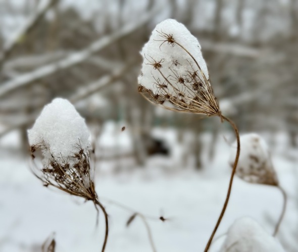 Cups of snow in Queen Anne’s lace
Morning Observation:
This morning in Huntington at 6:50AM it’s currently 32 degrees under cloudy skies and fog. Winds are calm. Relative humidity is 97%, dewpoint 32, barometric pressure 30.04”. We picked up a 0.2” dusting of snow last evening and have 5” at the stake. Yesterday’s high was 36, and yesterday’s low was 32. The overnight low got down to 32.
This morning in North Hero it’s currently 31 degrees under cloudy skies and fog. Winds are calm. Relative humidity is 99%, dewpoint 31, barometric pressure 30.09”. Yesterday’s high was 35, and yesterday’s low was 31. The overnight low got down to 31.
Forecast Discussion:
Morning radar imagery shows low pressure centered over Ohio at this hour with a wide swath of precipitation lifting northeastward into southern New England. The low is expected to track eastward during the day today and off the New England coast right around the Cape Cod benchmark. The current track will bring widespread snow into southern Vermont where Winter Weather Advisories have been post for southern counties. Generally 4″-8″ of snow is expected to fall over southern Vermont during the day today and into the evening with lesser amounts as you head north. We may pick 1″-3″ here in Huntington with little or none expected in North Hero. Precipitation will wind down overnight with some light snow showers lingering into Monday morning. Dry and seasonable conditions are expected for the first half of the week with temperatures again expected to warm to above seasonal averages midweek with highs on Thursday in the mid to upper 30s. The next chance of precipitation arrives later Thursday and through Friday as low pressure drops down from Canada.
3-Day Forecast:
We’ll see cloudy skies today with snow likely, possibly mixed with rain, mainly after 5:00PM. Highs will be near 36 with calm winds becoming easterly around 5 mph in the afternoon. Chance of precipitation is 60% with daytime snow accumulations of less than 0.50″ possible. Tonight should be cloudy with snow. Lows will be around 29 with north winds 5-9 mph. Chance of precipitation is 90% with new snow accumulations of 1″-3″ possible.
Monday should be cloudy with a 40% chance of morning snow. Highs will be near 32 with north winds around 10 mph. New snow accumulations of less than 0.50″ are possible. Monday night should be mostly cloudy with a low around 12 and north winds 3-7 mph.
Tuesday should be partly sunny with a high near 29 and calm winds. Tuesday night should be mostly cloudy with a low around 13 and southeast winds 3-5 mph.
Almanac:
Last year on this date in Huntington we had a high of 39 and a low of 23. We had 7.25″ of snow at the stake.
Last year in North Hero we had a high of 40 and a low of 30. We had 6″ of snow at the stake.
Burlington averages for this date are a low of 12 and a high of 28.
The record low was -20 in 2003 (We had a low of -24 in Huntington).
The record high was 51 in 2002 (we had a high of 54 in Huntington).
The Lake Champlain lake level in Burlington is 97.75′.
The water temperature is 36˚.
Last year’s lake level was at 96.78′.
The Mt. Mansfield snow stake depth is 48″.
The average depth for this date is 47″.
Mt. Washington Summit Conditions
Current Temperature: 22˚
Winds are out of the NW at 15-16 mph
24 hr Precipitation: 0
Visibility: around 50 miles with undercast
Sky Notes:
Sunrise: 7:14AM
Sunset: 4:55PM
Length of day: 9:40:34
today will be 2:20 longer than yesterday.
The Moon is waning gibbous, 17 days old with 94% illumination.
Moonrise: 7:55PM
Moonset: 8:54AM
About Today’s Photo:
Dried Queen Anne’s lace seed heads hold cups of snow after a light snowfall.
iPhone 15 Pro
Saturday, January 27, 2024

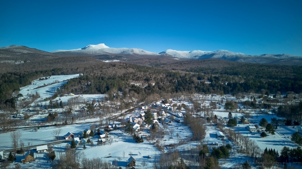
 Looking up East Street and Bert White Road towards the Hump
Morning Observation:
This morning in Huntington at 7:20AM it’s currently 32 degrees under cloudy skies. Winds are calm. Relative humidity is 97%, dewpoint 31, barometric pressure 30.21”. We picked up 0.50” of rain yesterday and have 5” of snow at the stake. Yesterday’s high was 39, and yesterday’s low was 32. The overnight low got down to 32.
This morning in North Hero it’s currently 31 degrees under cloudy skies. Winds are calm. Relative humidity is 99%, dewpoint 30, barometric pressure 30.26”. We picked up 0.27” of rain yesterday with bare ground at the stake. Yesterday’s high was 37, and yesterday’s low was 31. The overnight low got down to 31.
Forecast Discussion:
Morning dense fog advisories are up for our region this morning, but fog is expected to dissipate later this morning. We’ll see cloudy skies today with highs in the low to mid 30s and a slight chance of some drizzle or snow during the day. Low pressure tracking out of the Ohio River valley to our south on Sunday will bring increasing chances for precipitation during the day on Sunday. The storm’s southerly track will favor southern parts of Vermont where 4″-8″ of snow may fall south of Rutland and Windsor counties. Precipitation will drop off sharply as you head north with perhaps 1″-2″ here in Huntington. Dry and seasonable conditions return through midweek under a ridge of high pressure. The next chance for snow may arrive later Friday into Saturday as an Arctic front drops through the region.
3-Day Forecast:
We’ll see cloudy skies today with a slight chance of rain, snow, and freezing drizzle and areas of dense fog before 1:00PM. Highs will be near 35 with calm winds. Tonight should be cloudy with a low around 29 and calm winds.
Sunday should be cloudy with a 50% chance of snow. Highs will be near 36 with northeast winds around 6 mph. Little or no snow accumulation is expected. Sunday night should be cloudy with snow likely, mainly before 11:00PM. Lows will be around 28 with north winds 5-7 mph. Chance of precipitation is 60% with new snow accumulation of less than 1″ possible.
Monday should be cloudy with a high near 31 and north winds 8-10 mph. Monday night should be mostly cloudy with a low around 13 and north winds 3-8 mph.
Almanac:
Last year on this date in Huntington we had a high of 33 and a low of 12. We picked up 2″ of new snow and had 7.5″ at the stake.
Last year in North Hero we had a high of 34 and a low of 20. We had 7″ of snow at the stake.
Burlington averages for this date are a low of 12 and a low of 28.
The record low was -29 in 1994″.
The record high was 53 in 1996.
The Lake Champlain lake level in Burlington is 97.72′.
The water temperature is 36˚.
Last year’s lake level was at 96.90′.
The Mt. Mansfield snow stake depth is 49″.
The average depth for this date is 47″.
Mt. Washington Summit Conditions
Current Temperature: 25˚
Winds are calm, gusting out of the north to 16 mhph
24 hr Precipitation: 1.5″ snow, 0.21″ melted precipitation
Visibility: over 70 miles with undercast
Sky Notes:
Sunrise: 7:15AM
Sunset: 4:53PM
Length of day: 9:38:13
Today will be 2:18 longer than yesterday.
The Moon is waning gibbous, 16 days old with 97% illumination.
Moonrise: 6:52PM
Moonset: 8:35AM
About Today’s Photo:
Here’s a view looking up East Street and Bert White Road towards Camel’s Hump. Our house is tucked into the bottom right!
DJI Mini 3 drone, ISO 100, f/1.7, 1/2000″ exposure
Friday, January 26, 2024
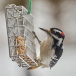
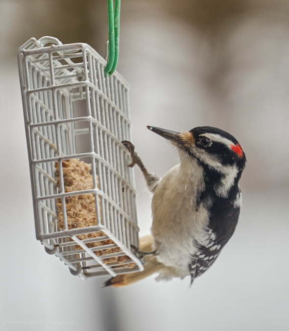 A hairy woodpecker visits our suet feeder
Morning Observation:
This morning in Huntington at 8:00AM it’s currently 35 degrees and raining under cloudy skies. Winds are calm. Relative humidity is 97%, dewpoint 35, barometric pressure 30.12”. We picked up 0.34” of rain yesterday and 0.31” so far today. We have 5.5” of snow at the stake. Yesterday’s high was 41, and yesterday’s low was 33. The overnight low got down to 33.
This morning in North Hero it’s currently 32 degrees and raining under cloudy skies and fog. Winds are calm. Relative humidity is 99%, dewpoint 32, barometric pressure 30.15”. We picked up 0.15” of rain yesterday, but the rain gauge appears to be iced up so it’s not reporting. I can see a bit of icing on the ground, but we’re down to bare ground at the stake. Yesterday’s high was 36, and yesterday’s low was 30. The overnight low got down to 31.
There is a Winter Weather Advisory in effect for our region until 7:00PM tonight.
Forecast Discussion:
Morning radar imagery shows low pressure over about Erie, PA at this hour with a warm front stretching eastward to about NYC. The low is expected to track northeastward during the day today bringing a mixed bag of wintery precipitation to the region. Icing is expected in the northern ‘Dacks and east of the Greens during the day today where colder air remains in place. The immediate Champlain Valley will likely see just plain rain. Precipitation is expected to change over to sleet, then snow by this evening as colder air to the north wins out over the warm nose pushing northward. We may see a dusting to 2″ of wet snow here in Huntington by the time precipitation winds down overnight. Surface high pressure will build in for Saturday bringing mostly dry conditions. Low pressure passing to our south will bring some snow to mostly southern Vermont where 3″-4″ of snow may fall. Depending on the low’s track, we may see a couple of inched here in Huntington. Another low on a similar track will pass to our south Sunday night into Monday bringing snow to southern areas. Seasonable but unsettled condition are expected heading into midweek next week.
3-Day Forecast:
We’ll see cloudy skies today with rain and sleet before 4:00PM, then a chance of rain, snow, and sleet after 5:00PM. Highs will be near 36 with southeast winds 6-11 mph. Chance of precipitation is 100% with little or no snow and sleet accumulation expected. Tonight should be cloudy with a slight chance of rain and snow showers before 1:00AM, then a slight chance of snow showers. Lows will be around 3 with east winds around 5 mph becoming calm in the evening. Chance of precipitation is 30% with little or no snow accumulation expected.
Saturday should be mostly cloudy with a 20% chance of snow showers. Highs will be near 35 with northwest winds around 5 mph. Saturday night should be mostly cloudy with a low around 28 and light and variable wind.
Sunday should be mostly cloudy with a high near 37 and northeast winds 3-6 mph. Sunday night should be cloudy with a 40% chance of snow showers. Lows will be around 19 with north winds 6-8 mph.
Almanac:
Last year on this date in Huntington we had a high of 39 and a low of 22. We picked up 2″ of snow and had 6.5″ at the stake.
Last year in North Hero we had a high of 32 and a low of 23. We picked up 3″ of new snow and had 7″ at the stake.
Burlington averages for this date are a low of 12 and a high of 28.
The record low was -25 in 1994.
The record high was 55 in 1950.
The Lake Champlain lake level in Burlington is 97.61′.
The water temperature is 36˚.
Last year’s lake level was at 96.99′.
The Mt. Mansfield snow stake depth is 54″ (from the 23rd).
The average depth for this date is 45″.
Mt. Washington Summit Conditions
Current Temperature: 30˚
Winds are out of the south at 14 gusting to 21 mph
24 hr Precipitation: 0
Visibility: about 1/16 mile in snow and fog
Sky Notes:
Sunrise: 7:16AM
Sunset: 4:52PM
Length of day: 9:35:55
Today will be 2:16 longer than yesterday.
I forgot to mention that the 23rd was Peak Meteorological Winter. This is the date that we see the coldest temperatures of the year in our location.
The Moon is waning gibbous, 15.3 days old with 99% illumination.
Moonrise: 5:46PM
Moonset: 8:12AM
About Today’s Photo:
We had a hairy woodpecker visit the feeder the other day. I haven’t seen one yet this season.
Sony A7II, Sigma 100-400mm lens @ 366mm, ISO 800, f/6.3, 1/60″ exposure
Thursday, January 25, 2024

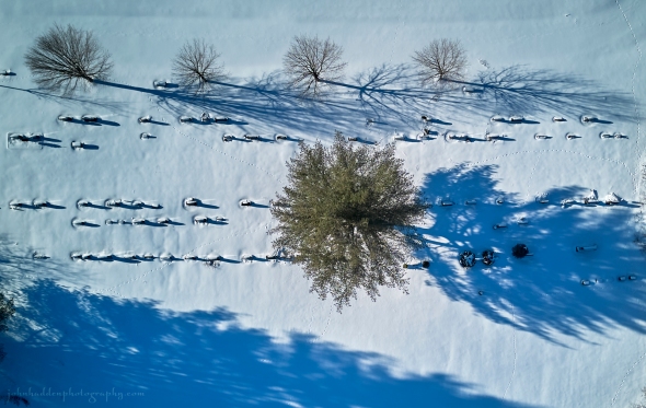 Long shadows across Maplewood Cemetery in Huntington
Morning Observation:
This morning in Huntington at 7:35AM it’s currently 34 degrees and drizzling a bit under cloudy skies. Winds are calm. Relative humidity is 97%, dewpoint 34, barometric pressure 30.14”. We picked up 0,.59” of rain/melted precipitation yesterday and 0.34” of rain so far today. Yesterday’s high was 41, and yesterday’s low was 23. The overnight low got down to 34.
This morning in North Hero it’s currently 30 degrees under cloudy skies and fog. Winds are calm. Relative humidity is 99%, dewpoint 30, barometric pressure 30.20”. We picked up 0.30” of rain/melted precipitation yesterday and 0.14” of rain with a bit of icing so far today. We’re down to bare ground at the stake. Yesterday’s high was 36, and yesterday’s low was 30.
Forecast Discussion:
Messy weather will be the rule for the next 24-36 hours. Morning road conditions could be a bit tricky given the much of the region has experienced at least a little bit of icing overnight with areas east of the Greens seeing the most. After a lull in precipitation through most of the day today, showers are expected to pick back up this evening and overnight tonight as low pressure tracking out of the Ohio River valley passes just to our west. Some icing is expected in colder locations by morning so be aware during the Friday morning commute. Messy mixed precipitation is expected to continue through much of the day Friday with southern areas seeing mostly all rain with sleet and snow mixing in over northern mountain locations. Precipitation will taper off to snow showers Friday night. Surface high pressure will build in for Saturday bringing dry and seasonably mild conditions with highs in the low to mid 30s. Low pressure is expected to skirt to our south later Sunday night into early Monday bringing some light snow to southern Vermont counties. Dry and more seasonable conditions are expected to start next week.
3-Day Forecast:
We’ll see cloudy skies today with a slight chance of morning drizzle and patchy fog. Highs will be near 37 with light and variable winds. Tonight should be cloudy with a slight chance of rain before 10:00PM, then rain likely after 1:00AM. Lows will be around 33 with calm winds becoming southeasterly 5-8 mph after midnight. Chance of precipitation is 70% with rainfall amounts of less than 0.10″ possible.
Friday should be cloudy with rain before 3:00PM, mixing with snow into the evening. Highs will be near 37 with southeast winds 5-11 mph. Chance of precipitation is 100% with little or no snow accumulation expected. Friday night should be cloudy with rain showers likely before 2:00AM, then a chance of snow showers. Lows will be around 31 with light and variable winds. Chance of precipitation is 60% with little or no snow accumulation expected.
Saturday should be mostly cloudy with a 30% chance of snow showers before 9:00AM. Highs will be near 37 with light northwest winds. New snow accumulations of less than 0.50″ are possible. Saturday night should be cloudy with a low around 29 and light northwest winds.
Almanac:
Last year on this date in Huntington we had a high of 32 and a low of 18. We picked up 0.50″ of new snow and had 6″ at the stake.
Last year in North Hero we had a high of 31 and a low of 13. We had 5″ of snow at the stake.
Burlington averages for this date are a low of 12 and a high of 28.
The record low was -15 in 1968.
The record high was 54 in 2010 (we had a high of 53 in Huntington).
The Lake Champlain lake level in Burlington is 97.61′.
The water temperature is 36˚.
Last year’s lake level was at 96.96′.
The Mt. Mansfield snow stake depth is 54″ (reported 1/23).
The average depth for this date is 45″.
Mt. Washington Summit Conditions
Current Temperature: 26˚
Winds are out of the NW at 51-54 mph
24 hr Precipitation: 0.8″ snow, 0.49″ melted precipitation
Visibility: around 1/16 mile in freezing fog
Sky Notes:
Sunrise: 7:17AM
Sunset: 4:51PM
Length of day: 9:33:38
Today will be 2:13 longer than yesterday.
The Moon is the full “Wolf” moon, (Northeast Native American), 14.4 days old with 100% illumination.
Moonrise: 4:39PM
Moonset: 7:43AM
About Today’s Photo:
Low afternoon light cast long shadows across Maplewood Cemetery in Huntington. I’m particularly fascinated by the lines of animal tracks meandering through the headstones. Hard to tell at this distance, but they look like fox tracks.
DJI Mini 3 drone, ISO 100, f/1.7, 1/2000″ exposure
Wednesday, January 24, 2024

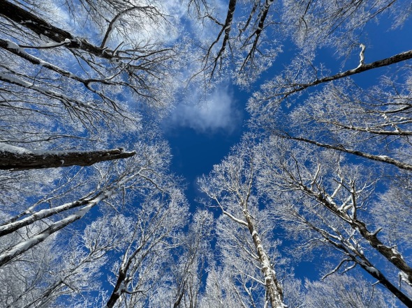 Blue sky and snowy trees on Lion’s Ridge
Morning Observation:
This morning in Huntington at 6:50AM it’s currently 30 degrees and snowing lightly under cloudy skies. Winds are calm. Relative humidity is 91%, dewpoint 28, barometric pressure 30.47”. We picked up 2” of new snow and have 9” at the stake. Yesterday’s high was 32, and yesterday’s low was 24. The overnight low got down to 23.
This morning in North Hero it’s currently a still-chilly 18 degrees and snowing lightly under cloudy skies. Winds are calm. Relative humidity is 94%, dewpoint 17, barometric pressure 30.56”. We picked up about 2” of new snow and have 3” at the stake. Yesterday’s high was 37, and yesterday’s low was 19. The overnight low got down to 17.
There is a Winter Weather Advisory in effect for our region now until 1:00PM today, and until 7:00AM Thursday in eastern Vermont.
Forecast Discussion:
The cold front that dropped through the region overnight bringing snow is now lifting back northward as a warm front. The temperature difference between Huntington and North Hero tells the story of the fronts movement as warmer air has already begun to move in to Huntington. Morning snow showers are expected to wind down by midmorning as temperatures rise into the mid to upper 30s over most of the region. After a lull through much of the day, low pressure tracking to our west will bring increasing chances for rain and freezing rain overnight tonight. It’s looking like Huntington and most of the Champlain Valley will avoid any icing, but areas east of the Greens will likely pick up a few hundredths of an inch overnight tonight making for potentially hazardous travel by Thursday morning. Precipitation is expected to change over to all rain by Thursday morning as temperatures bump into the upper 30s to mid 40s. Rains will become spotty on Thursday and reinvigorate Thursday night and into Friday as temperatures remain well above freezing. There’s also some potential for a recurrence of icing over eastern Vermont overnight Thursday into Friday morning. Temperatures are expected to slide towards freezing by Friday night allowing any remaining precipitation to change over to snow by early Friday night. Dry and unseasonably mild conditions are expected Saturday with more seasonable temperatures returning by Sunday.
3-Day Forecast:
We’ll see cloudy skies today with snow showers winding down this morning with rain showers after 4:00PM. Highs will be near 37 with south winds around 10-15. Chance of precipitation is 100% with daytime snow accumulations of less than 1″ possible. Tonight should be cloudy with showers. Lows will be around 35 with south winds 8-15 mph. Chance of precipitation is 90% with rainfall amounts between 0.25″-0.50″ possible.
Thursday should be mostly cloudy with a 40% chance of showers, mainly after 4:00PM. Highs will be near 38 with northwest winds around 5 mph becoming calm in the afternoon. Rainfall amounts of less than 0.10″ are possible. Thursday night should be cloudy with showers, mainly after 9:00PM. Lows will be around 34 with southeast winds 8-13 mph. Chance of precipitation is 90% with rainfall amounts between 0.10″-0.25″ possible.
Friday should be cloudy with showers. Highs will be near 41 with southeast winds 5-11 mph becoming westerly in the afternoon. Chance of precipitation is 90% with rainfall amounts between 0.10″-0.25″ possible. Friday night should be cloudy with snow showers likely before 7:00PM. Lows will be around 32 with northwest winds around 6 mph becoming calm in the evening. Chance of precipitation is 60%.
Almanac:
Last year on this date in Huntington we had a high of 35 and a low of 26. We picked up 0.7″ of new snow and had 6″ at the stake.
Last year in North Hero we had a high of 37 and a low of 27. We had 5″ of snow at the stake.
Burlington averages for this date are a low of 12 and a high of 28.
The record low was -22 in 1948.
The record high was 52 in 1999.
The Lake Champlain lake level in Burlington is 97.62′.
The water temperature is 36˚.
Last year’s lake level was at 97.00′.
The Mt. Mansfield snow stake depth is 54″.
The average depth for this date is 45″.
Mt. Washington Summit Conditions
Current Temperature: 13˚
Winds are out of the SW at 24 gusting to 35 mph
24 hr Precipitation: 1.3″ snow, 0.14″ melted precipitation
Visibility: around 1/16 mile in freezing fog
Sky Notes:
Sunrise: 7:18AM
Sunset: 4:49PM
Length of day: 9:31:25
Today will be 2:10 longer than yesterday.
The Moon is waxing gibbous, 13.4 days old with 98% illumination.
Moonrise: 3:32PM
Moonset: 7:07AM
About Today’s Photo:
Nothing beats the contrast of snow and rime trimmed trees against the bright blue of a winter sky.
iPhone 15 Pro
Tuesday, January 23, 2024
 Portrait of a village, part 2
Morning Observation:
This morning in Huntington at 6:50AM it’s currently 31 degrees under cloudy skies. Winds are calm. Relative humidity is 85%, dewpoint 27, barometric pressure 30.39”. We have 7.25” of snow at the stake. Yesterday’s high was 32, and yesterday’s low was -2. The overnight low got down to 28.
This morning in North Hero it’s currently 32 degrees under cloudy skies. Winds are calm. Relative humidity is 87%, dewpoint 28, barometric pressure 30.43”. We have 0.50” of snow at the stake. Yesterday’s high was 34, and yesterday’s low was 16. The overnight low got down to 32.
There is a Winter Weather Advisory in effect for our region from 7:00PM tonight until 7:00AM Thursday.
Forecast Discussion:
We’ve got some messy weather ahead of us for the next 48 hours or so. A cold front will drop through the region during the day today then stall and move back north as a warm front bringing chances for snow later this afternoon and into tonight. We may see a couple of inches out of this initial round of precipitation by Wednesday morning. The light snow should come to an end by Wednesday morning with mostly dry conditions expected Wednesday as warm air moves into the region and slowly begins to scour out the cold air. Things will begin to get “interesting” overnight Wednesday as low pressure tracking to our west brings renewed precipitation into the region. Temperatures at ground levels will likely be cold enough for some freezing rain to fall, especially in the St. Lawrence valley and NEK where some moderate ice accretions may occur. It’s a bit of a tricky forecast for the Champlain Valley, as areas like Plattsburgh and Highgate may see icing, with just plain cold rain in Burlington. Regardless, the Thursday morning commute is likely to be messy so be prepared. Warm air advection will push daytime highs into the upper 30s to mid 40s region-wide during the day on Thursday with all areas changing over to rain. Rain will persist overnight Thursday into Friday, winding down by Friday afternoon with warm air still in place. Saturday is looking dry and mild with highs in the upper 30s. Cooler air will finally begin to drop into the region by Sunday with some snow showers possible.
3-Day Forecast:
We’ll see cloudy skies today with a 30% chance of afternoon snow. Highs will be near 30 with west winds 5-8 mph becoming northerly in the afternoon. Little or no snow accumulation is expected. Tonight should be cloudy with snow, mainly after 8:00PM. Lows will be around 20 with calm winds becoming southeasterly around 6 mph after midnight. Chance of precipitation is 80% with new snow accumulations of less than 1″ possible.
Wednesday should be cloudy with snow likely in the morning, then a chance of rain and snow. Highs will be near 35 with southeast winds 8-10 mph. Chance of precipitation is 70% with new snow accumulations of less than 1″ possible. Wednesday night should be cloudy with rain, snow, and freezing rain likely before 7:00PM, mixing with freezing rain, then rain after 10:00PM. Lows will be around 35 with south winds 8-14 mph. Chance of precipitation is 90% with little or no snow accumulation expected.
Thursday should be cloudy with a 70% chance of rain. Highs will be near 39 with south winds around 5 mph becoming calm in the morning. Rainfall amounts of less than 0.10″ are possible. Thursday night should be cloudy with rain. Lows will be around 36 with southeast winds 5-8 mph. Chance of precipitation is 80% with rainfall amounts between 0.10″-0.25″ possible.
Almanac:
Last year on this date in Huntington we had a high of 31 and a low of 27. We picked up 2.7″ of new snow and had 6″ at the stake.
Last year in North Hero we had a high of 32 and a low of 29. We had 5″ of snow at the stake.
Burlington averages for this date are a low of 12 and a high of 28.
The record low was -19 in 1970.
The record high was 51 in 1957.
The Lake Champlain lake level in Burlington is 97.71′.
The water temperature is 35˚.
Last year’s lake level was at 97.06′.
The Mt. Mansfield snow stake depth is 55″.
The average depth for this date is 44″.
Mt. Washington Summit Conditions
Current Temperature: 8˚
Winds are out of the NW at 60 gusting to 74 mph
24 hr Precipitation: 0.6″ snow, 0.05″ melted precipitation
Visibility: less than 1/16 mile in freezing fog and blowing snow
Sky Notes:
Sunrise: 7:20AM
Sunset: 4:47PM
Length of day: 9:27:06
Today will be 2:05 longer than yesterday.
The Moon is waxing gibbous, 12.5 days old with 94% illumination.
Moonrise: 2:29PM
Moonset: 6:21AM
About Today’s Photo:
I got the drone back in the sky the other day as sunny skies made for some good shooting. I wanted to get a portrait of the Lower Village to complement the one I did of Huntington Center earlier this month.
DJI Mini 3 drone, ISO 100, f/1.7, 1/2000″ exposure
Monday, January 22, 2024

 A bluebird day on Lion’s Ridge yesterday
Morning Observation:
This morning in Huntington at 7:20AM it’s currently 13 degrees under mostly cloudy skies. Winds are calm. Relative humidity is 92% dewpoint 11, barometric pressure 30.46”. We have 8” of snow at the stake. Yesterday’s high was 15, and yesterday’s low was -2. The overnight low got down to -2.
This morning in North Hero it’s currently 20 degrees under mostly cloudy skies. Winds are out of the south at 20-25 mph. Relative humidity is 86%, dewpoint 16, barometric pressure 30.50”. We have 1” of snow at the stake. Yesterday’s high was 19, and yesterday’s low was 9. The overnight low got down to 16.
Forecast Discussion:
After a chilly start to the day, temperatures will be on the increase along with cloud cover as a southerly airflow sets up. Indeed, we’re already seeing winds gusting to 25 mph at our camp in North Hero. Highs today will be much warmer than yesterday, in the upper 20s to low 30s. There’s a slight chance of some mountain snow showers later today and into tonight as a weak disturbance skirts to our north. Tuesday’s looking seasonably mild with ongoing slight chances of snow showers during the day. A more pronounced trough will lift into the region Tuesday night into Wednesday with light snow likely overnight. Unfortunately, we’ll also see the beginning of an extended period of warm weather arriving midweek with snow showers Wednesday changing over to sleet and then eventually rain overnight as warm air pushes into the region. Low pressure tracking to our west will once again put us on the warm side of the storm system with highs on Thursday pushing into the 40s with rain showers likely. Warm and showery weather is expected to persist through Friday with dry conditions expected Saturday as temperatures begin to move back down to more seasonable levels by Sunday. One silver lining to this system is that there doesn’t appear to be a whole lot of moisture available so snowpack impacts should be mitigated.
3-Day Forecast:
We’ll see increasing clouds today with a 20% chance of snow showers after 3:00PM. Highs will be near 32 with south winds 6-11 mph in Huntington and 15-20 mph in the Champlain Valley. Tonight should be mostly cloudy with a 20% chance of snow showers before 11:00PM. Lows will be around 24 with southwest winds 8-14 mph.
Tuesday should be mostly cloudy with a slight chance of snow showers. Highs will be near 32 with north winds around 8 mph. Tuesday night should be cloudy with snow likely, mainly after 11:00PM. Lows will be around 21 with southeast winds around 6 mph. Chance of precipitation is 70% with new snow accumulations of less than 1″ possible.
Wednesday should be cloudy with snow likely before 4:00PM, then a chance of snow and sleet. Highs will be near 33 with south winds 8-12 mph. Chance of precipitation is 60% with snow and sleet accumulations of less than 0.50″ possible. Wednesday night should be cloudy with a 50% chance of rain and sleet before 7:00PM, then a chance of rain. Lows will be around 33 with south winds 7-12 mph. Precipitation amounts of less than 0.10″ are possible.
Almanac:
Last year on this date in Huntington we had a high of 32 and a low of 26. We had 4.5″ of snow at the stake.
Last year in North Hero we had a high of 33 and a low of 30. We had 5″ of snow at the stake.
Burlington averages for this date are a low of 12 and a high of 28.
The record low was -22 in 1970.
The record high was 53 in 1959.
The Lake Champlain lake level in Burlington is 97.72′.
The water temperature is 36˚.
Last year’s lake level was at 97.11′.
The Mt. Mansfield snow stake depth is 55″.
The average depth for this date is 44″.
Mt. Washington Summit Conditions
Current Temperature: 6˚
Winds are out of the west at 54 mph gusting to 66 mph.
24 hr Precipitation: 0
Visibility: 60 miles
Sky Notes:
Sunrise: 7:20AM
Sunset: 4:47PM
Length of day: 9:27:06
Today will be 2:05 longer than yesterday.
The Moon is waxing gibbous, 11.6 days old with 89% illumination.
Moonrise: 1:32PM
Moonset: 5:23AM
About Today’s Photo:
I took a lovely ski up to the Lion’s Ridge Trail yesterday morning. This is undoubtedly one of my favorite trails at Camel’s Hump Nordic, and it certainly didn’t disappoint! A bluebird sky above and plenty of snow on the ground made for an excellent tour.
iPhone 15 Pro
Sunday, January 21, 2024

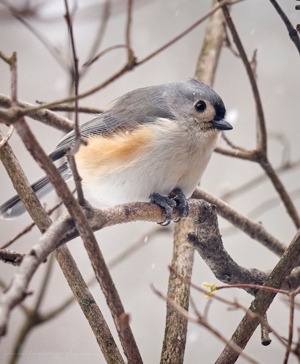 A close-up portrait of a tufted titmouse
Morning Observation:
This morning in Huntington at 7:40AM it’s currently 8 degrees and “snizzling” a bit under overcast skies. Winds are calm. Relative humidity is 82%, dewpoint 4, barometric pressure 30.30”. We picked up 1” of fluffy new snow in in the past 24hrs and have 8.25” at the stake. Yesterday’s high was 11, and yesterday’s low was 4. The overnight low got down to 8.
This morning in North Hero it’s currently 10 degrees under cloudy skies. Winds are calm. Relative humidity is 76%, dewpoint 4, barometric pressure 30.43”. We have 1” of snow at the stake. Yesterday’s high was 14, and yesterday’s low was 6. The overnight low got down to 10.
Forecast Discussion:
We’ve got another chilly day on tap for today with highs only in the mid teens and gusty northwest winds. After some early Lake Champlain effect snow, we should see some glimpses of sun by this afternoon. After a mostly clear and chilly night tonight, winds will shift into the south allowing temperatures to recover to more seasonable levels on Monday. A trough of low pressure is expected to drop into the region on Tuesday bringing some snow showers Tuesday afternoon into Wednesday. Much warmer air is expected to push into the region from midweek into the weekend with highs in the mid 30s Wednesday and around 40 Thursday into Saturday. While there is no large scale organized system on the horizon, bits of toughiness will be swinging through each day bringing chances for precipitation in the form of rain or snow showers Wednesday through Friday.
3-Day Forecast:
We’ll see partly sunny skies today with a 20% chance of morning snow showers. Highs will be near 16 with northwest winds 9-11 mph. Tonight should be mostly clear with a low around 6 and south winds around 6 mph.
Monday should bring increasing clouds with a high near 32 and south winds 8-14 mph. Monday night should be cloudy with a low around 26 and southwest winds 7-14 mph.
Tuesday should be cloudy with a 30% chance of snow after 5:00PM. Highs will be near 32 with west winds 6-8 mph becoming northerly in the afternoon. Tuesday night should be cloudy with snow likely, mainly after 7:00PM. Lows will be around 23 with north winds around 5 mph becoming calm. Chance of precipitation is 70%.
Almanac:
Last year on this date in Huntington we had a high of 29 and a low of 23. We picked up 2″ of new snow and had 5″ at the stake.
Last year in North Hero we had a high of 31 and a low of 24. We picked up 1″ of new snow and had 6″ at the stake.
Burlington averages for this date are a low of 12 and a high of 28.
The record low was -19 in 1943.
The record high was 54 in 2006 (we had a high of 58 in Huntington).
The Lake Champlain lake level in Burlington is 97.88′.
The water temperature is 35˚.
Last year’s lake level was at 97.14′.
The Mt. Mansfield snow stake depth is 55″.
The average depth for this date is 44″.
Mt. Washington Summit Conditions
Current Temperature: 6˚
Winds are out of the NW at 50-59 mph
24 hr Precipitation: 2.2″ snow, 0.13″ melted precipitation
Visibility: around 70 miles under clear skies.
Sky Notes:
Sunrise: 7:20AM
Sunset: 4:45PM
Length of day: 9:25:00
Today will be 2:02 longer than yesterday.
The Moon is waxing gibbous,
10.6 days old with 82% illumination.
Moonrise: 12:45PM
Moonset: 4:17AM
About Today’s Photo:
The cold temperatures have made our feeder an especially busy place over the past couple of days, and the chickadees and titmice have been hard at it chowing down as many calories as they can manage. These two species are referred to as “allies” and you often see each other in company. Where chickadees are the bolder of the two species, tufted titmice are a bit shyer. This little feller was perched right outside our kitchen window, and I managed to get a shot as it looked up between rounds of pecking at the sunflower that you can see pinned under its feet. I love the bit of eye liner above its eye!
Sony A7II, Sony 24-240mm lens @ 240mm, ISO 800, f/9, 1/250″ exposure
Saturday, January 20, 2024

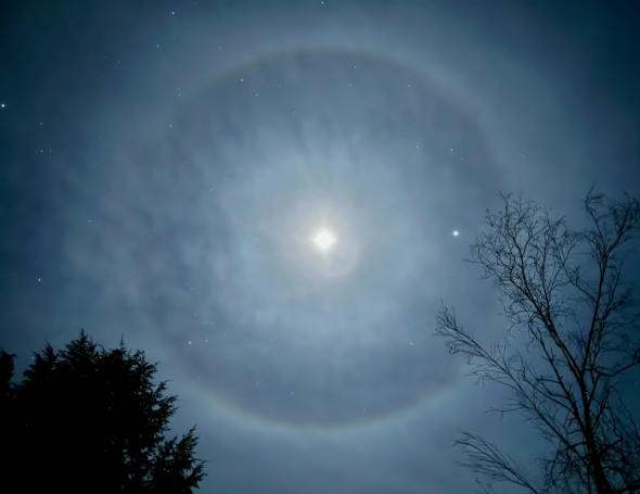
A halo around last evening’s moon
Morning Observation:
This morning in Huntington at 7:35AM it’s currently 4 degrees under cloudy skies. Winds are calm. Relative humidity is 81%, dewpoint -1, barometric pressure 29.96”. We have 7.5” of snow at the stake. Yesterday’s high was 19, and yesterday’s low was 2. The overnight low got down to 2.
This morning in North Hero it’s currently 7 degrees under cloudy skies. Winds are calm. Relative humidity is 76%, dewpoint 1, barometric pressure 30.11”. We have 1” of snow at the stake, and our south-facing cove has a thin skim of ice extending out a couple hundred yards. Yesterday’s high was 21, and yesterday’s low was 7. The overnight low got down to 6.
Forecast Discussion:
We’ve got a chilly couple of days ahead courtesy of modified Arctic air that has pushed into the region on building high pressure. Highs today will be in the upper single digits to low teens and drop back into the single digits either side of zero tonight. A weak disturbance will drop through the region during the day today bringing some light snow showers to Vermont with northwest facing slopes of the northern Greens and ‘Dacks perhaps picking up 1″-3″ of fluff. Sunday’s looking dry and cold with highs again only in the low teens but with some breaks of sun expected in the afternoon under cresting high pressure. The high is expected to slide to our east Monday setting up a southerly airflow and allowing temperatures to recover back to more seasonable levels. Diffuse shortwave energy will swing through later in the day Monday bringing some light snow showers into Monday night. Unsettled and warming conditions are expected from midweek into the weekend with a general southwesterly upper level airflow steering several weak systems through the region. While nothing looks particularly impactful, we’ll see off-and-on rounds of precipitation with both rain and snow as temperatures approach 40 degrees on Thursday and into the weekend.
3-Day Forecast:
We’ll see cloudy skies today with snow showers likely, mainly after 1:00PM. Highs will be near 11 with northwest winds 9-13 mph. Chance of precipitation is 70% with daytime snow accumulations of less than 1″ possible. Tonight should be cloudy with snow showers likely, mainly before 8:0PM. Lows will be around 5 with northwest winds 10-15 mph. Chance of precipitation is 60% with new snow accumulations of less than 1″ possible.
Sunday should be mostly sunny with a high near 14 and northwest winds 9-15 mph. Sunday night should be mostly clear with a low around 5 and calm winds becoming southerly around 6 mph after midnight.
Monday should be mostly sunny with a high near 30 and south winds 8-14 mph. Monday night should be cloudy with a low around 23 and southwest winds 7-11 mph.
Almanac:
Last year on this date in Huntington we had a high of 38 and a low of 28. We had 2″ of snow at the stake.
Last year in North Hero we had a high of 35 and a low of 26. We picked up 3″ of new snow and had 5.5″ at the stake.
Burlington averages for this date are a low of 12 and a high of 28.
The record low was -22 in 1970.
The record high was 52 in 1951.
The Lake Champlain lake level in Burlington is 97.94′.
The water temperature is 37˚.
Last year’s lake level was at 97.16′.
The Mt. Mansfield snow stake depth is 55″.
The average depth for this date is 43″.
Mt. Washington Summit Conditions
Current Temperature: 3˚
Winds are out of the north at 23 gusting to 35 mph
24 hr Precipitation: 0.1″ snow, 0.01″ melted precipitation
Visibility: around 1/16 mile with freezing fog and blowing snow.
Sky Notes:
Sunrise: 7:21AM
Sunset: 4:44PM
Length of day: 9:22:58
Today will be 1:59 longer than yesterday.
The Moon is waxing gibbous, 9.6 days old with 73% illumination.
Moonrise: 12:08PM
Moonset: 3:04AM
About Today’s Photo:
Last night’s waxing gibbous moon sported a nice halo as light filtered through upper atmosphere ice crystals. A smattering of stars and bright Jupiter to the right complete the scene.
iPhone 15 Pro
Friday, January 19, 2024

 Deep snow in the saddle between Bald Hill and Camel’s Hump
Morning Observation:
This morning in Huntington at 8:05AM it’s currently 15 degrees and snowing lightly under cloudy skies. Winds are calm. Relative humidity is 88%, dewpoint 12, barometric pressure 29.98”. We picked up 0.70” of fluff overnight and have 8.5” at the stake. Yesterday’s high was 24, and yesterday’s low was 8. The overnight low got down to 15.
This morning in North Hero it’s currently a brisk 9 degrees under mostly cloudy skies. Winds are out of the north at 3-5 mph. Relative humidity is 74%, dewpoint 3, barometric pressure 30.14”. We have 1” of snow at the stake. Yesterday’s high was 26, and yesterday’s low was 19. The overnight low got down to 8.
Forecast Discussion:
Outside of a few Lake Champlain effect snow flurries this morning, we should see a dry and chilly day today with highs topping out in the mid teens and brisk north winds. Some of the coldest air of the season is expected for the weekend under building Arctic high pressure with overnight lows tonight dropping into the single digits either side of zero and highs Saturday and Sunday again only in the low to mid teens. A weak disturbance will pass to our north on Saturday bringing some scattered snow showers over northern mountains and the NEK where 1″-3″ of fluff may fall. High pressure will push to our east by Monday setting up a southerly airflow and allowing temperatures to recover to more seasonable levels heading into next week. We’ll see a bit of a warmup midweek with temperatures pushing above seasonal norms Wednesday into Thursday. This will coincide with a rather diffuse low pressure system which will bring periods of snow and rain to the region Wednesday and Thursday. Doesn’t look like a washout at this point so there’s that…
3-Day Forecast:
We’ll see mostly cloudy skies today with a high near 14 and north winds 6-8 mph. Tonight should be cloudy with a slight chance of snow showers after 1:00AM. Lows will be around 2 with northwest winds 9-13 mph.
Saturday should be cloudy with a 50% chance of snow showers. Highs will be near 12 with northwest winds 9-14 mph. New snow accumulations of less than 1″ are possible. Saturday night should be mostly cloudy with a 50% chance of snow showers. Lows will be around 6 with northwest winds 8-10 mph. New snow accumulation of less than 0.50″ are possible.
Sunday should be mostly sunny with a high near 16 and northwest winds 7-10 mph. Sunday night should be partly cloudy with a low around 3 and light and variable winds becoming southerly around 6 mph after midnight.
Almanac:
Last year on this date in Huntington we had a high of 35 and a low of 27. We had 0.5″ of snow at the stake.
Last year in North Hero we had a high of 33 and a low of 30. We had 1.5″ of snow at the stake.
Burlington averages for this date are a low of 12 and a high of 28.
The record low was -24 in 1976.
The record high was 65 in 1996.
The Lake Champlain lake level in Burlington is 98.02′.
The water temperature is 37.
Last year’s lake level was at 97.19′.
The Mt. Mansfield snow stake depth is 52″.
The average depth for this date is 43″.
Mt. Washington Summit Conditions
Current Temperature: -5
Winds are out of the west at 35-38 mph
24 hr Precipitation: 0.9″ snow, 0.09″ melted precipitation
Visibility: around 80 miles
Sky Notes:
Sunrise: 7:22AM
Sunset: 4:43PM
Length of day: 9:20:58
Today will be 1:56 longer than yesterday.
The Moon is waxing gibbous, 8.6 days old with 63% illumination.
Moonrise: 11:38AM
Moonset: 1:49AM
About Today’s Photo:
Intrepid Catamount Trail Steward, Bill Hegman, led me on a great 10-mile adventure along “his” section of the CT yesterday. We climbed to the saddle between Bald Hill and Camel’s Hump where we found over 3′ of snow on the ground and powder clinging to branches like velvet on a deer’s antlers. Perfect! Thanks Bill!
 Bill Hegman on the Catamount Trail
Thursday, January 18, 2024

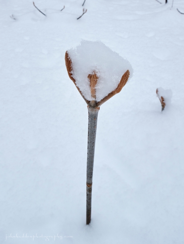 Hobblebush cups new-fallen snow
Morning Observation:
This morning in Huntington at 7:15AM it’s currently 13 degrees under cloudy skies. Winds are calm. Relative humidity is 78%, dewpoint 8, barometric pressure 30.01”. We have 8” of snow at the stake. Yesterday’s high was 19, and yesterday’s low was 5. The overnight low got down to 8.
This morning in North Hero it’s currently 21 degrees under cloudy skies. Winds are out of the south at 5-8 mph. Relative humidity is 75%, dewpoint 14, barometric pressure 30.05”. We have 1” of snow at the stake. Yesterday’s high was 24, and yesterday’s low was 14. The overnight low got down to 19.
Forecast Discussion:
Not a whole lot going on weather-wise for the next several days, and outside of a few Lake Ontario effect streamers over northern Vermont, Vermont should remain largely precipitation free heading into the weekend. The bigger story is the arrival of some modified Arctic high pressure which will drop into the region on a northwest airflow starting Friday bringing in some of the coldest temperatures yet this season. Overnight lows will be in the single digits either side of zero with daytime highs only in the low teens Friday through Sunday. A weak upper level shortwave will cross the region Saturday bringing a chance of some light snow. Winds are expected to shift into the southwest Sunday night as high pressure slides to our east and warmer air starts to move back into the region. Our next chance of significant precipitation arrives later Tuesday into Wednesday, and while it’s a ways out, model trends are suggesting some of the dreaded “R” word. Stay tuned…
3-Day Forecast:
We’ll see mostly cloudy skies today with a 30% chance of afternoon snow showers. Highs will be near 23 with west winds 6-10 mph. Daytime snow accumulations of less than 0.50″ are possible. Tonight should be mostly cloudy with a 30% chance of snow showers, mainly before 11:00PM. Lows will be around 9 with southwest winds around 5 mph becoming calm in the evening. New snow accumulation of less than 0.50″ are possible.
Friday should be mostly cloudy with a high near 16 and north winds 5-7 mph. Friday night should be mostly cloudy with a low around 4 and north winds 8-10 mph.
Saturday should be mostly cloudy with a 50% chance of snow showers. Highs will be near 12 with northwest winds around 9 mph. New snow accumulations of less than 1″ are possible. Saturday night should be cloudy with a low around 6 and northwest winds around 9 mph.
Almanac:
Last year on this date in Huntington we had a high of 35 and a low of 30. We had 0.5″ of snow at the stake.
Last year in North Hero we had a high of 37 and a low of 32. We had 1.5″ of snow at the stake.
Burlington averages for this date are a low of 12 and a high of 28.
The record low was -24 in 1974.
The record high was 53 in 1996.
The Lake Champlain lake level in Burlington is 98.07′.
The water temperature is 36˚.
Last year’s lake level was at 97.22′.
The Mt. Mansfield snow stake depth is 52″.
The average depth for this date is 42″.
Mt. Washington Summit Conditions
Current Temperature: -9
Winds are out of the north at 61 gusting to 71 mph
24 hr Precipitation: 0.2″ snow, 0.03″ melted precipitation
Visibility: less than 1/16 mile with freezing fog and blowing snow
Sky Notes:
Sunrise: 7:22AM
Sunset: 4:42PM
Length of day: 9:19:02
Today will be 1:53 longer than yesterday.
The Moon is waxing gibbous, 7.5 days old with 52% illumination.
Moonrise: 11:13AM
Moonset: 12:34AM
About Today’s Photo:
The snow fell light and fluffy in the woods, and the tridents of hobblebush buds gathered cups of snow…
Canon G5X II, 8.8mm, ISO 100, f/11, 1/160″ exposure
Wednesday, January 17, 2024

 Sunrise over our camp cove this morning
Morning Observation:
This morning in Huntington at 7:15AM it’s currently a brisk 5 degrees under partly cloudy skies. Winds are calm. Relative humidity is 89%, dewpoint 3, barometric pressure 29.80”. We picked up a total of 6.2” of fluff in the past 24hrs and have 9.5” at the stake. Yesterday’s high was 23, and yesterday’s low was 11. The overnight low got down to 5.
This morning in North Hero it’s currently 14 degrees under partly cloudy skies. Winds are calm, and ice is beginning to form on our south cove. Relative humidity 82%, dewpoint 19, barometric pressure 29.89”. We picked up 1” of new snow in the past 24hrs and have 1” at the stake. Yesterday’s high was 24, and yesterday’s low was 15. The overnight low got down to 14.
Forecast Discussion:
We’ll see mostly dry and seasonably cool conditions today and heading into the weekend over most of Vermont. The one exception will be some persistent Lake Ontario effect snow showers over northern New York (with Lake Effect Storm Warnings just downwind of the lake) which should extend into the the northern Vermont mountains where a few inches may fall between now and Thursday from about Mt. Mansfield north to Jay Peak. Modified Arctic air is expected to push into the region over the weekend bringing dry conditions and our coldest temperatures of the season with highs on Friday and Saturday struggling to make into the teens. Temperatures will begin to moderate by early next week as a southwesterly airflow sets up.
3-Day Forecast:
We’ll see increasing clouds today with a 50% chance of afternoon snow showers. Highs will be near 21 with southwest winds 7-11 mph. Total daytime snow accumulations of less than 1″ are possible. Tonight should be mostly cloudy with a 20% chance of snow showers before 9:00PM. Lows will be around 13 with southwest winds 9-13 mph.
Thursday should be mostly cloudy with a 30% chance of snow showers, mainly after 4:00PM. Highs will be near 22 with southwest winds 7-10 mph. New snow accumulations of less than 0.50″ are possible. Thursday night should be mostly cloudy with a 30% chance of snow showers before 7:00PM. Lows will be around 7 with light and variable winds becoming northerly around 5 mph after midnight.
Friday should be partly sunny and chilly with a high near 14 and north winds 5-8 mph. Friday night should be cloudy with a low around 2 and north winds around 10 mph.
Almanac:
Last year on this date in Huntington we had a high of 38 and a low of 17. We had 1.5″ of snow at the stake.
Last year in North Hero we had a high of 35 and a low of 23. We had 1.7″ of snow at the stake.
Burlington averages for this date are a low of 12 and a high of 28.
The record low was -22 in 1974.
The record high was 52 in 1990.
The Lake Champlain lake level in Burlington is 98.15′.
The water temperature is 37˚.
Last year’s lake level was at 97.25′.
The Mt. Mansfield snow stake depth is 50″.
The average depth for this date is 41″.
Mt. Washington Summit Conditions
Current Temperature: -10
Winds are out of the NW at 66 gusting to 76 mph
24 hr Precipitation: 5.8″ snow, 0.45″ melted precipitation
Visibility: less than 1/16 mile in freezing fog and blowing snow.
Sky Notes:
Sunrise: 7:23AM
Sunset: 4:40PM
Length of day: 9:17:09
Today will be 1:50 longer than yesterday.
The Moon is in its first quarter, 6.5 days old with 41% illumination.
Moonrise: 10:51AM
No Moonset
About Today’s Photo:
While we’ve got some clouds here in Huntington this morning, the sky is pretty much clear up in North Hero. Calm overnight winds have allowed the ice to start forming in our south-facing cove.
Wyze Cam 3
Tuesday, January 16, 2024

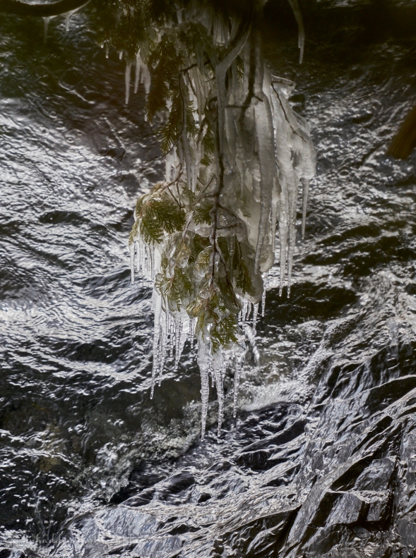 An “ice chandelier” below the cliff at camp
Morning Observation:
This morning in Huntington at 7:30AM it’s currently 18 degrees under cloudy skies. Winds are calm. Relative humidity 74%, dewpoint 12, barometric pressure 30.06”. We have 5” of snow at the stake. Yesterday’s high was 23, and yesterday’s low was 9. The overnight low got down to 9.
This morning in North Hero it’s currently 23 degrees under cloudy skies. Winds are out of the south at 6-8 mph. Relative humidity is 68%, dewpoint 14, barometric pressure 30.11”. Still largely snow free. Yesterday’s high was 27, and yesterday’s low was 22. The overnight low got down to 22.
There is a Winter Weather Advisory in effect until 10:00PM tonight.
Forecast Discussion:
Morning radar imagery shows low pressure off the coast of Delaware with bands of precipitation stretching northeastward basically along the spine of the Appalachian mountain chain. This low is expected to track up the coast before heading out to see somewhere near Cape Cod today. Snow is already beginning to push into southern Vermont at this time and areal coverage will increase during the day over the entire region. Widespread snow is expected with 3″-5″ likely locally here in Huntington with amounts diminishing towards the international border with 2″-4″ possible in North Hero. Snow should wind down later this evening with some lingering showers possible over northern upslope mountains. Outside of a few Lake Ontario effect snow showers north on Wednesday, dry and seasonably cool conditions will be the rule heading into the latter half of the week with chillier air moving in for the weekend under building modified Arctic high pressure. No significant weather is expected through this period which will come as a bit of a relief given what we’ve had to deal with of late…
3-Day Forecast:
We’ll see cloudy skies today with snow likel, mainly after 8:00AM. Highs will be near 23 with southeast winds 5-9 mph becoming light and variable in the afternoon. Chance of precipitation is 100% with daytime snow accumulations of 3″-5″ possible. Tonight should be cloudy with snow likely before 9:00PM, winding down around 10:00PM. Lows will be around 10 with northwest winds 7-10 mph. Chance of precipitation is 80% with snow accumulations of less than 1″ possible.
Wednesday should be partly sunny with a 40% chance of afternoon snow showers. Highs will be near 20 with southwest winds 6-10 mph. New snow accumulations of less than 0.50″ are possible. Wednesday night should be mostly cloudy with a low around 11 and southwest winds 8-11 mph.
Thursday should be mostly cloudy with a high near 23 and west winds 7-9 mph. Thursday night should be mostly cloudy with a low around 6 and west winds around 6 mph becoming light and variable after midnight.
Almanac:
Last year on this date in Huntington we had a high of 22 and allow of 9. We had 1.5″ of snow at the stake.
Last year in North Hero we had a high of 25 and a low of 16. We had 2.7″ of snow at the stake.
Burlington averages for this date are a low of 12 and a high of 29.
The record low was -21 in 2009 (We had a low of -20 in Huntington).
The record high was 63 in 1995.
The Lake Champlain lake level in Burlington is 98.25′.
The water temperature is 38˚.
Last year’s lake level was at 97.34′.
The Mt. Mansfield snow stake depth is 46″.
The average depth for this date is 40″.
Mt. Washington Summit Conditions
Current Temperature: 7
Winds are out of the SW at 21 gusting to 38 mph
24 hr Precipitation: 0
Visibility: around 5 miles under blowing snow
Sky Notes:
Sunrise: 7:24AM
Sunset: 4:39PM
Length of day: 9:15:19
Today will be 1:46 longer than yesterday.
The Moon is a waxing crescent, 5.4 days old with 30% illumination.
Moonrise: 10:31AM
Moonset: 11:18PM
About Today’s Photo:
We visited our camp in North Hero yesterday. The lake level continues to be pretty high, but it makes for some interesting ice formations on vegetation along the shore. This shot is looking down through the cedar trees above our cliff. Splashing waves have built up a thick layer of ice on one of the cedar branches giving it a chandelier effect.
Sony A7II, Sony 24-240mm lens @ 139mm, ISO 800, f/9, 1/125″ exposure
Monday, January 15, 2024

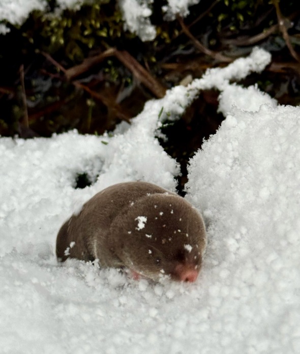 A shrew wiggles atop the snow
Morning Observation:
This morning in Huntington at 6:25AM it’s currently 15 degrees under partly cloudy skies. Winds are calm. Relative humidity is 79%, dewpoint 9, barometric pressure 30.10”. We picked up a quick 2.4” of new snow yesterday afternoon around 2:00PM when a squall ripped through. We have 5” at the stake. Yesterday’s high was 32, and yesterday’s low was 22. The overnight low got down to 15.
This morning in North Hero it’s currently 23 degree under partly cloudy skies. Winds are out of the south at 5-8 mph. Relative humidity is 70%, dewpoint 15, barometric pressure 30.14”. No snow on the ground. Yesterday’s high was 36, and yesterday’s low was 26. The overnight low got down to 23.
Forecast Discussion:
We’ve got a dry and partly sunny day on tap for today courtesy of a ridge of high pressure cresting over the region. Highs today will be on the chilly side topping out in the low to mid 20s with gusty southwest winds. A trough will pass to our south on Tuesday bringing some widespread light snow to the region beginning overnight tonight. Accumulations of 1″-5″ can be expected north to south with highest amounts over southern counties. Locally we may see 2″-4″ here in Huntington with 1″-3″ in North Hero. Snow will taper off Tuesday evening. Dry and seasonably chilly conditions are expected for midweek under the influence of low pressure centered over Hudson Bay which will rotate cool Arctic air into the region. There’s still an outside chance of some snow again on Friday as low pressure tracks to our south, but at this point it’s looking less likely. Dry and chilly conditions are expected heading into the weekend as Arctic high pressure drops into the region.
3-Day Forecast:
We’ll see mostly sunny skies today with a high near 23 and southwest winds 10-13 mph. Tonight should bring increasing clouds with a 40% chance of snow showers late. Lows will be around 12 with south winds 5-10 mph. Little or no snow accumulation is expected.
Tuesday should be cloudy with light snow likely. Highs will be near 24 with southeast winds 6-8 mph becoming westerly in the afternoon. Chance of precipitation is 100% with new snow accumulations of 2″-4″ possible. Tuesday night should be mostly cloudy with a 30% chance of snow showers before 10:0PM. Lows will be around 10 with northwest winds 5-7 mph.
Wednesday should be mostly cloudy with a high near 20 and southwest winds 5-9 mph. Wednesday night should be mostly cloudy with a low around 10 and southwest winds 8-13 mph.
Almanac:
Last year on this date in Huntington we had a high of 21 and a low of 12. We picked up 0.30″ of new snow and had 1.75″ at the stake.
Last year in North Hero we had a high of 26 and a low of 17. We had 3″ of snow at the stake.
Burlington averages for this date are a low of 13 and a high of 29.
The record low was -30 in 1957 (brrrrr!)
The record high was 66 in 1995.
The Lake Champlain lake level in Burlington is 98.26′.
The water temperature is 38˚.
Last year’s lake level was at 97.31′.
The Mt. Mansfield snow stake depth is 48″.
The average depth for this date is 40″.
Mt. Washington Summit Conditions
Current Temperature: -4
Winds are out of the west at 51-55 mph
24 hr Precipitation: 2.9″ snow, 0.22″ melted precipitation
Visibility: less than 1/16 mile freezing fog
Sky Notes:
Sunrise: 7:24AM
Sunset: 4:38PM
Length of day: 9:13:32
Today will be 1:43 longer than yesterday.
The Moon is a waxing crescent, 4.3 days old with 19% illumination.
Moonrise: 10:10AM
Moonset: 10:02PM
About Today’s Photo:
I’ve often shown shrew tracks and the remains of their little tunnels running just below the surface of the snow, but it’s not too often that I lay an eye on the actual critter. Robin spotted this little guy scurrying across the snow yesterday afternoon after the squall. It was looking for an entrance to dig in below the snow where shrews spend most of their time in the winter. A dense, frozen snowpack makes it hard for subnivean dwellers, as they’re unable to dig down to the ground in search of food.
iPhone 15 Pro
Sunday, January 14, 2024

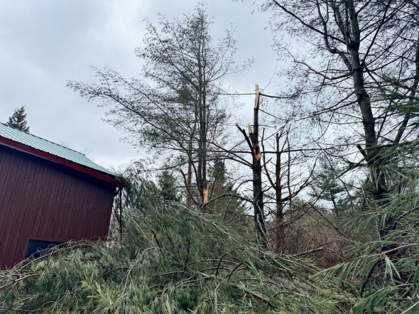 Snapped white pines behind our barn
Morning Observation:
This morning in Huntington at 7:30AM it’s currently 29 degrees under partly cloudy skies. Winds are calm. Relative humidity is 75%, dewpoint 22, barometric pressure 29.59”. We picked up 0.53” of rain yesterday and a 0.40” dusting of frozen sleet/snow. We have 4” of snow at the stake. Yesterday’s high was 43, and yesterday’s low was 32. The overnight low got down to 29.
This morning in North Hero it’s currently 30 degrees under partly cloudy skies. Winds are out of the south at 3-5 mph. Relative humidity is 85%, dewpoint 26, barometric pressure 29.61”. We picked up 0.31” of rain yesterday and have just a dusting of snow at the stake. Yesterday’s high was 41, and yesterday’s low was 27. The overnight low got down to 29.
So yesterday’s winds appear to have been much more damaging here in Huntington than the previous storm. We had a max gust of 43 mph around 8:30AM, and a couple of white pines behind our barn snapped and clipped the corner of the roof resulting in some broken trim. But there were reports from around the neighborhood of many fallen trees, trees across power lines, a house had its metal roof peeled off, and another had half its siding torn off. And of course the power is out again. As exciting as those storms were, I’m glad they’re behind us!
Forecast Discussion:
While it’s partly cloudy here now, morning radar imagery shows a potent band of lake effect snow showers streaming eastward off of Lake Ontario. These showers, reinforced by an approaching Arctic air boundary, are expected to move into Vermont later this afternoon, and the NWS has released a “Special Statement” warning of potential snow squalls between 11:00AM and 5:00PM. We could pick up a quick 1″-3″ of snow during these squalls with the possibility of white-out conditions as they come through. Quieter conditions are expected overnight and into Monday for Vermont with seasonably cool temperature and gusting southwest winds. A strong shortwave trough is expected to swing through the region on Tuesday bringing some widespread light snow yielding maybe 1″ of accumulation. An upper level low over Hudson Bay will be the main engine of our weather heading into midweek as it rotates colder air into the region and driving the occasional band of lake effect snow showers into Vermont through the end of the week. There’s an outside chance of a coastal low developing as we head into the weekend, but it’s too far out for any certainty at this time.
3-Day Forecast:
We’ll see mostly cloudy skies today with a 50% chance of snow showers, mainly after 10:0AM. The snow could be heavy at times. Highs will be near 30 with southwest winds 16-22 mph gusting to 36 mph. Total daytime snow accumulations of 1″-3″ are possible. Tonight should be mostly cloudy with a 30% chance of snow showers, mainly before 9:00PM. Lows will be around 15 with southwest winds 10-16 mph.
Monday should be mostly sunny with a high near 23 and southwest winds 10-13 mph. Monday night should be mostly cloudy with a low around 13 and south winds around 7 mph.
Tuesday should be cloudy with snow showers likely, mainly after 1:00PM. Highs will be near 23 with south winds 6-8 mph. Chance of precipitation is 60% with snow accumulations of around 1″ possible. Tuesday night should be mostly cloudy and chilly with a low around 7 and light and variable winds becoming westerly around 5 mph after midnight.
Almanac:
Last year on this date in Huntington we had a high of 23 and a low of 20. We picked up 0.80″ of new snow and had 1.5″ at the stake.
Last year in North Hero we had a high of 24 and a low of 21. We picked up 4″ of snow and had 4″ at the stake.
Burlington averages for this date are a low of 13 and a high of 29.
The record low was -25 in 1957.
The record high was 60 in 1995.
The Lake Champlain lake level in Burlington is 98.30′.
The water temperature is 39˚.
Last year’s lake level was at 97.31′
The Mt. Mansfield snow stake depth is 35″.
The average depth for this date is 39″.
Mt. Washington Summit Conditions
Current Temperature: 5
Winds are out of the west at 62 gusting to 73 mph
24 hr Precipitation: 9.9″ snow, 1.98″ melted precipitation
Visibility: less than 1/16 mile in freezing fog and blowing snow
Sky Notes:
Sunrise: 7:25AM
Sunset: 4:36PM
Length of day: 9:11:49
Today will be 1:39 longer than yesterday.
The Moon is a waxing crescent, 3 days old with 11% illumination.
Moonrise: 9:47AM
Moonset: 8:43PM
About Today’s Photo:
We got off a better than some of our neighbors during the wind storms, but we weren’t unscathed. Two of our pines snapped off clipping the corner of the barn and causing some minor damage, and there are several other branches down around our property. It’ll be chainsaw work for me today as we clean up.
iPhone 15 Pro
Saturday, January 13, 2024

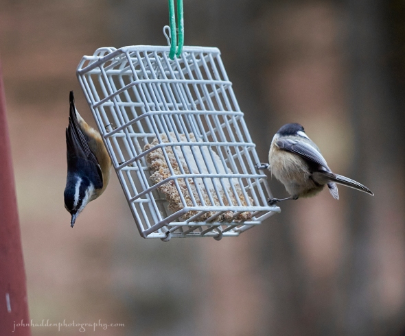 A red-breasted nuthatch and chickadee share our suet feeder
Morning Observation:
This morning in Huntington at 7:30AM it’s currently 40 degrees and raining under overcast skies. Winds are out of the southeast at 15-25 mph gusting to 38 mph (so far…) Relative humidity is 83%, dewpoint 36, barometric pressure 29.21”. We picked up 0.08” of rain/melted precipitation yesterday and 0.01” so far today. We have 5” of snow at the stake. Yesterday’s high was 38, and yesterday’s low was 22. The overnight low got down to 35.
This morning in North Hero it’s currently 39 degrees and raining under overcast skies. Winds are out of the south at 15-20 mph gusting to 30 mph. Relative humidity is 86%, dewpoint 35, barometric pressure 29.33”. We picked up 0.01” of rain/melted precipitation so far today, and are down to bare ground at the stake. Yesterday’s high was 31, and yesterday’s low was 22. The overnight low got down to 27.
There is a High Wind Warning in effect for our region until 11:00AM this morning.
Forecast Discussion:
Morning radar imagery shows the center of deep low pressure over Lake Superior at this hour with a warm front extending eastward into New England. Rain will persist through much of the day today as strong to damaging downslope winds continue along the western slopes of the Greens through midmorning. A trailing cold front is expected to cross the region later today as the aforementioned low tracks northeastward. Highs today will top out in the mid 40s today and begin to fall later this afternoon as winds switch into the southwest and mellow a bit. Precipitation is expected to switch over to periods of snow showers by this evening with little or no accumulation expected. A weak shortwave is expected to cross the region on Sunday bringing some snow showers and possible snow squalls with light accumulations possible. Dry and seasonable conditions are expected heading into early next week with the slight possibility of a coastal low developing Tuesday night into Wednesday. Stay tuned…
3-Day Forecast:
We’ll see cloudy skies today with rain showers before 5:00PM, then a chance of rain and snow showers. Highs will be near 40 with southeast winds 33-43 mph becoming southwesterly 9-14 mph in the afternoon. Winds could gust as high as 70 mph. Chance of precipitation is 100% with daytime snow accumulations of less than 0.50″ possible. Tonight should be mostly cloudy with a low around 25 and southwest winds 14-20 mph gusting to 33 mph.
Sunday should be cloudy with afternoon snow showers likely. Highs will be near 29 with southwest winds 16-18 mph gusting to 31 mph. Chance of precipitation is 60% with snow accumulations of less than 0.50″ possible. Sunday night should be mostly cloudy with a 30% chance of snow showers. Lows will be around 16 with southwest winds 10-18 mph gusting to 29 mph. New snow accumulations of less than 0.50″ are possible.
Monday should be mostly cloudy with a high near 24 and southwest winds around 11 mph. Monday night should be mostly cloudy with a low around 11 and south winds 7-9 mph.
Almanac:
Last year on this date in Huntington we had a high of 40 and a low of 23. We picked up 0.64″ of rain and were down to bare ground at the stake.
Last year in North Hero we had a high of 24 and a low of 22. We picked up 0.36″ of rain and 0.10″ of snow and had a trace at the stake.
Burlington averages for this date are a low of 13 and a high of 29.
The record low was -20 in 1957.
The record high was 55 in 2005 (we had a high of 62 in Huntington).
The Lake Champlain lake level in Burlington is 98.23′.
The water temperature is 38˚.
Last year’s lake level was at 97.19′.
The Mt. Mansfield snow stake depth is 35″.
The average depth for this date is 39″.
Mt. Washington Summit Conditions
Current Temperature: 17
Winds are out of the SE at 87 gusting to 96 mph
24 hr Precipitation: 4.6″ snow, 0.57″ melted precipitation
Visibility: less than 1/16 mile under snow and freezing fog
Sky Notes:
Sunrise: 7:25AM
Sunset: 4:35PM
Length of day: 9:10:09
Today will be 1:36 longer than yesterday.
The Moon is a waxing crescent, 2 days old with 5% illumination.
Moonrise: 9:21AM
Moonset: 7:21PM
About Today’s Photo:
Continuing our bird feeder theme, a red-breasted nuthatch and chickadee share our suet feeder. No matter how much I encouraged them, however, I couldn’t get them to both look at the camera at the same time…
Sony A7II, Sigma 100-400mm lens @ 240mm, ISO 2500, f/6.3, 1/125″ exposure
Friday, January 12, 2024

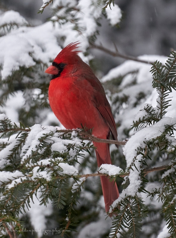 A fine specimen of a male cardinal
Morning Observation:
This morning in Huntington at 7:20AM it’s currently 25 degrees under cloudy skies. Winds are calm. Relative humidity is 94%, dewpoint 24, barometric pressure 30.16”. We picked up 1.4” of new snow in the past 24hrs and have 5.4” at the stake. Yesterday’s high was 35, and yesterday’s low was 26. The overnight low got down to 25. Still without power here…
This morning in North Hero it’s currently 23 degrees under cloudy skies. Winds are calm. Relative humidity is 87%, dewpoint 20, barometric pressure 30.25”. We picked up 0.50” of snow in the past 24hrs and have 0.50” at the stake. Yesterday’s high was 35, and yesterday’s low was 25. The overnight low got down to 23.
The is (another) High Wind Warning in effect for our region from 11:00PM tonight until 10:00AM Saturday.
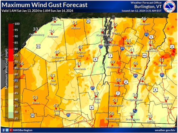
Forecast Discussion:
We’ve got another quiet-before-the-storm day ahead of us today courtesy of a brief ridge of high pressure that will crest over the region. We might even see a glimpse of sunshine midday before clouds build back in ahead of our next weather system. This one is looking a whole lot like the last one, albeit with slightly less severe winds. Low pressure currently over the Mississippi River is expected to track up through Michigan today lifting an occluded/warm front through our region overnight. We’ll see snow showers moving into Vermont later this evening into the overnight hours. Moderate snowfall is expected to kick things off with 3″-6″ possible over southern Vermont counties with 1″-3″ farther northward. Precipitation is expected to transition to a period of mixed precipitation before daybreak, then to rain during the day Saturday as highs climb into the low to mid 40s. Rain should transition back to snow in the evening into the overnight hours with little or no accumulation expected. So that’s the precipitation. Now for the winds… Once again we’ll be seeing strong to damaging downsloping winds along the western slopes of the Greens overnight tonight into Saturday morning. Forecast models are signaling a slightly more easterly track which would indicate that stronger winds will be more likely in the eastern Addison and Chittenden counties. Peak gusts of 60-65 mph are possible, and, need I say it, power outages are likely. But considering we and many of our neighbors are still without power going into our third day, well, whatever—we’ll roll with it… Lingering Lake Ontario effect snow showers will continue into Sunday. Monday’s looking dry and partly sunny with highs in the mid 20s. Seasonable temperatures are expected through much of next week with perhaps some snow Tuesday night.
3-Day Forecast:
We’ll see mostly cloudy skies today with a high near 32 and light and variable winds. Tonight should be cloudy with snow likely before 4:00AAM, then snow, possibly mixed with rain. The snow could be heavy at times. Temperature will be rising to around 35 by 5:00AM. It’ll be windy with a southeast wind 8-18 mph increasing to 28-38 mph and gusting to 55 mph. Chance of precipitation is 80% with new snow accumulations of around 1″ possible.
Saturday should be cloudy with rain before 4:00PM, then rain and snow showers likely. Highs will be near 42 with southeast winds 27-37 mph becoming southwesterly 9-14 mph in the afternoon. Winds could gust as high as 60 mph. Chance of precipitation is 90% with new accumulations of less than 0.50″ possible. Saturday night should be mostly cloudy with a 40% chance of snow showers. Lows will be around 24 with southwest winds 14-20 mph gusting to 33 mph. New snow accumulations of less than 0.50″ ar possible.
Sunday should be cloudy with a 40% chance of snow showers. Highs will be near 28 with southwest winds 17-20 mph gusting to 32 mph. Little or no snow accumulation is expected. Sunday night should be mostly cloudy with a low around 15 and west winds 13-21 mph gusting to 33 mph.
Almanac:
Last year on this date in Huntington we had a high of 40 and a low of 28. We picked up 0.40″ of rain and had 1″ of snow at the stake.
Last year in North Hero we had a high of 37 and a low of 27. We picked up 0.41″ of rain and had bare ground at the stake.
Burlington averages for this date are a low of 13 and a high of 29.
The record low was -23 in 1968.
The record high was 61 in 2018 (we had a high of 63 in Huntington).
The Lake Champlain lake level in Burlington is 98.19′.
The water temperature is 38˚.
Last year’s lake level was at 97.05′.
The Mt. Mansfield snow stake depth is 33″.
The average depth for this date is 38″.
Mt. Washington Summit Conditions
Current Temperature: 7
Winds are out of the west at 62 gusting to 72 mph
24 hr Precipitation: 1.6″ snow, 0.12 melted precipitation
Visibility: less than 1/16 mile in blowing snow and freezing fog
Sky Notes:
Sunrise: 7:26AM
Sunset: 4:34PM
Length of day: 9:08:33
Today will be 1:32 longer than yesterday.
The Moon is a waxing crescent, 1 day old with 1% illumination.
Moonrise: 8:48AM
Moonset: 5:57PM
About Today’s Photo:
Keeping to the theme of likely bird suspects visiting our feeder this time of year, this resplendent male cardinal posed in our hemlock tree. He was certainly ready for his close up…
Sony A7II, Sigma 100-400mm lens @ 400mm, ISO 1250, f/6.3, 1/160″ exposure
Thursday, January 11, 2024
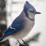
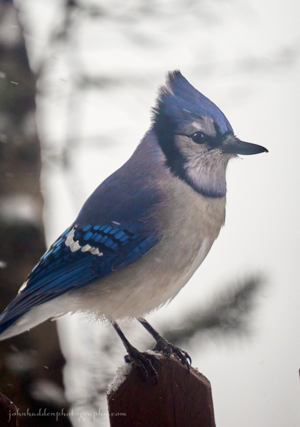 A bluejay poses for its portrait on our front porch
Morning Observation:
This morning in Huntington at 7:50AM it’s currently 32 degrees under cloudy skies. Winds are calm. Relative humidity is 82%, dewpoint 27, barometric pressure 29.71”. We picked up 1.09” of rain/melted precipitation yesterday and have 4” of frozen snow at the stake. Yesterday’s high was 44, and yesterday’s low was 35. The overnight low got down to 32.
This morning in North Hero it’s currently 30 degrees under cloudy skies. Winds are calm. Relative humidity is 79%, dewpoint 24, barometric pressure 29.77”. We picked up 0.24” of rain/melted precipitation yesterday, and are pretty much down to bare ground at the stake with the exception of of a few drifts here and there. Yesterday’s high was 45, and yesterday’s low was 35. The overnight low got down to 29.
There is a High Wind Watch in effect for our region from 10:00PM Friday until 10:00AM Saturday.
Forecast Discussion:
We’ve got mostly quiet and seasonable conditions ahead of us for the next 36 hours or so. A weak trough is expected to skirt to our north today bringing some scattered to numerous snow shower during the afternoon and into the evening. Valley locations will likely only see a dusting with 1″-3″ above 1000′, and perhaps a bit more over favored upslope mountain summits of the northern Greens. A brief ridge of high pressure is expected to build in Friday bringing perhaps a glimpse of sunshine. Then we’re on to our next storm system…
As mentioned yesterday, this system has a lot of the same characteristics as our last storm system. Low pressure will track out of the Mississippi River valley and into the Great Lakes Friday into Saturday, and well to our west on Sunday. We’ll once again be squeezed between a departing ridge of high pressure and the low with resultant high winds along the western slopes of the Greens once again expected. We’ll also be getting another round of mixed precipitation, starting off as a period of snow Friday night, transitioning to rain Saturday, then wrapping up as snow flurries on the back side lingering into Monday. Thankfully models are indicating that winds, while strong, are unlikely to be as strong as our last storm.
Incidentally, I got a report of 82 mph right up the hill at the Camel’s Hump Nordic Ski Center before their anemometer blew apart, and the Mark Breen at the Fairbanks Museum told me this morning that there was a report of 91 mph from Huntington Center. Yikes! Hopefully nothing like that from the upcoming storm, but we will likely see gusting ranging into the 50-60 mph range. So if you’ve got anything else that didn’t get blown away the first time, keep it battened down. Seasonable conditions with a few random snow showers are expected heading into early next week.
3-Day Forecast:
We’ll see cloudy skies today with scattered afternoon snow showers. Highs will be near 34 with west winds 6-9 mph. Chance of precipitation is 50% with snow accumulations of around 1″ possible. Tonight should be cloudy with scattered snow showers, mainly before 11:00PM. Lows will be around 21 with northwest winds 3-5 mph. Chance of precipitation is 50% with new snow accumulation of less than 1″ possible.
Friday should be partly sunny with a 30% chance of snow, mainly after 4:00PM. Highs will be near 32 with light and variable winds. Little or no snow accumulation expected. Friday night should be cloudy with snow before 5:00AM, then snow, possibly mixed with sleet. Lows will be around 26 with southeast winds 8-18 mph increasing to 19-29 mph after midnight. Winds could gust as high as 55 mph. Chance of precipitation is 100% with new snow and sleet accumulation of 1″-3″ possible.
Saturday should be cloudy with rain before 4:00PM, mixing with snow towards sunset. Highs will be near 44 with southeast winds 24-29 mph becoming southwesterly 14-19 mph in the afternoon. Winds could gust as high as 50 mph. Chance of precipitation is 90% with new snow accumulations of less than 0.50″ possible. Saturday night should be mostly cloudy with rain and snow showers likely before 7:00PM, then a chance of snow showers. Lows will be around 21 with southwest winds 17-22 mph gusting to 37 mph. Chance of precipitation is 60%w with rainfall amounts of less than 0.10″ possible.
Almanac:
Last year on this date in Huntington we had a high of 29 and a low of 4. We had 1″ of snow at the stake.
Last year in North Hero we had a high of 27 and a low of 15. We had a dusting of snow at the stake.
Burlington averages for this date are a low of 13 and a high of 29.
The record low was -27 in 1968.
The record high was 59 in 2020 (we had a high of 59 in Huntington).
The Lake Champlain lake level in Burlington is 98.23′.
The water temperature is 39˚.
Last year’s lake level was at 97.15′.
The Mt. Mansfield snow stake depth is 33″.
The average depth for this date is 38″.
Mt. Washington Summit Conditions
Current Temperature: 9
Winds are out of the west at 62 mph gusting to 71 mph
24 hr Precipitation: 2.7″ snow, 0.83″ melted precipitation
Visibility: less than 1/16 mile in freezing fog and blowing snow
Sky Notes:
Sunrise: 7:26AM
Sunset: 4:33PM
Length of day: 9:07:01
Today will be 1:28 longer than yesterday.
The Moon is new, 29 days old with 0% illumination.
Moonrise: 8:05AM
Moonset: 4:34PM
About Today’s Photo:
We’ve got a decent herd of bluejays in attendance at the feeder this season. They seem to come in a pack in the morning and again in the afternoon. This one was patient enough for me to get a nice portrait if him/her!
Sony A7II, Sigma 100-400mm lens @ 400mm, ISO 1250, f/6.3, 1/320″ exposure
Wednesday, January 10, 2024

 A mourning dove naps in the hemlock near the feeder
Well that certainly was a noisy night! I’m guessing that many of you are out of power this morning in the wake of the wind. We lost power here around 11:30PM last night—it’ll probably be a pretty long outage…
Morning Observation:
This morning in Huntington at 6:35AM it’s currently 42 degrees and raining under cloudy skies. Winds are out of the west at 5-7 mph. Relative humidity is 93%, dewpoint 41, barometric pressure 28.99”. We picked up 0.47” of rain/melted precipitation so far today. We had 3” of sodden snow on the storm board this morning, but whether that is new snow or just drifted snow is anyone’s guess. I’m guessing more the latter. We have 4.5” at the stake. We had a top wind gust of 54 mph overnight which is a new record for us. Yesterday’s high was 37, and yesterday’s low was 21. The overnight low got down to 37.
This morning in North Hero (where the power is still miraculously on…) it’s currently 40 degrees and raining under cloudy skies. Winds are light out of the west. Relative humidity is 97%, dewpoint 39, barometric pressure 28.98”. We picked up 0.01” of rain/melted precipitation yesterday and 0.03” so far today. We have about 2” of snow at the stake, though it looks like there’s a fair amount of scouring to the ground in places. We had a top wind gust of 42 mph. Yesterday’s high was 38, and yesterday’s low was 24. The overnight low got down to 38.
The High Wind Warning has been cancelled.
Forecast Discussion:
Morning radar imagery shows low pressure over Lake Superior with an occluded/cold front running southeastward from the low down into Connecticut. Rain is stretched along this frontal boundary, and we should see one more round of heavier rains before precipitation becomes more showery in nature this afternoon. Gusty southwest winds are also expected to develop this afternoon. Highs today will top out in the mid 40s and start dropping this afternoon. Any lingering precipitation will change over to snow at higher elevations later today, with snow levels gradually dropping into the valleys by this evening. Little or now snow accumulation is expected. After a brief break in the precipitation tomorrow morning, an upper level shortwave will bring some snow showers in the afternoon, especially over the northern mountains where we may pick up an additional 1″-2″ of snow. Friday’s looking dry and seasonable as a brief ridge of high pressure builds in. Another impactful storm system is expected later Friday night into Saturday. At this point it’s looking an awful lot like the storm we just had, with low pressure tracking to our west through the Great Lakes bringing gusty winds, snow, then rain, then snow to the North Country. This one’s not looking as fierce as our last however, but stay tuned…
3-Day Forecast:
We’ll see cloudy skies today with rain before 8:00AM, then showers likely into the afternoon. Temperature will top out in the mid 40s this morning and fall to around 36 by 5:00PM with southwest winds 5-14 mph gusting to 38 mph. Chance of precipitation is 100% with rainfall amounts between 0.10″-0.25″ possible. Tonight should be mostly cloudy with a low around 27 and southwest winds 7-14 mph becoming westerly after midnight.
Thursday should be mostly cloudy with a 30% chance of afternoon snow showers. Highs will be near 33 with southwest winds 6-10 mph. New snow accumulations of less than 0.50″ are possible. Thursday night should be mostly cloudy with a low around 22 and northwest winds around 7 mph.
Friday should be partly sunny with a high near 31 and northwest winds around 6 mph becoming calm in the afternoon. Friday night should be cloudy with snow. Lows will be around 21 with southeast winds 6-11 mph increasing to 19-24 mph after midnight and gusting to 40 mph. Chance of precipitation is 100%.
Almanac:
Last year on this date in Huntington we had a high of 32 and a low of 7. We picked up 0.70″ of new snow and had 1″ at the stake.
Last year in North Hero we had a high of 34 and a low of 16. We picked up 0.2″ of new snow and had 0.2″ at the stake.
Burlington averages for this date are a low of 14 and a high of 29.
The record low was -22 in 1968.
The record high was 53 in 2016 (we had a high of 51 in Huntington and had set a new record high wind of 48 mph. Interesting coincidence!)
The Lake Champlain lake level in Burlington is 98.23′.
The water temperature is 38˚.
Last year’s lake level was at 97.20′.
The Mt. Mansfield snow stake depth is 28″ (reported the 9th).
The average depth for this date is 37″.
Mt. Washington Summit Conditions
Current Temperature: 26
Winds are out of the SE at 57 mph gusting to 69 mph. They reported a top gust of 108 mph last night at 3:10AM.
24 hr Precipitation: 18.9″ snow, 3.18″ melted precipitation
Visibility: around 1/16 mile in freezing fog and blowing snow
Sky Notes:
Sunrise: 7:26AM
Sunset: 4:32PM
Length of day: 9:05:32
Today will be 1:24 longer than yesterday.
The Moon is a waning crescent, 28 days old with 2% illumination.
Moonrise: 7:10AM
Moonset: 3:18PM
About Today’s Photo:
We have 3 pairs of mourning doves in attendance so far this winter. When they’re not poking about in the snow below the feeder, I’ll often find them napping as a group in the hemlock in our side yard. The dense foliage offers a comfortable and safe refuge for them.
Sony A7II, Sigma 100-400mm lens @ 400mm, ISO 1250, f/6.3, 1/250″ exposure
Tuesday, January 9, 2024

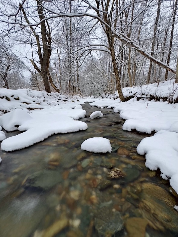 Fargo Brook looking appropriately wintery
Morning Observation:
This morning in Huntington at 6:50AM it’s currently 21 degrees under cloudy skies. Winds are calm. Relative humidity is 95%, dewpoint 20, barometric pressure 30.36”. We have 4” of snow at the stake. Yesterday’s high was 30, and yesterday’s low was 20. The overnight low got down to 21.
This morning in North Hero it’s currently 25 degrees under cloudy skies. Winds are calm. Relative humidity is 95%, dewpoint 23, barometric pressure 30.42”. We have 5” of snow at the stake. Yesterday’s high was 32, and yesterday’s low was 21. The overnight low got down to 24.
There is a High Wind Warning in effect for our region from 4:00PM this afternoon until 7:00AM Wednesday.
Forecast Discussion:
It’s the calm before the storm… Morning radar and satellite imagery shows deep low pressure currently spinning over southwestern Missouri with a frontal boundary stretching southeastward toward a triple point low near the lower Mississippi River Valley. This whole system will lift northeastward through the day today, with the primary low eventually passing to our west on Wednesday. A broad swath of precipitation is already spreading northeast into the Ohio River Valley ahead of the front, and it is this that will first impact us later this afternoon into the evening hours. Temperatures will be cold enough that heavy wet snow is expected to move into southern Vermont by this afternoon, reaching the Champlain Valley by early evening. A quick 2″-7″ of heavy, wet snow is possible over southern areas with a maybe 1″ farther north before precipitation changes over to rain overnight. The main threat for this storm, however, will be winds as we’re squeezed between deep low pressure to our northwest and high pressure over the Canadian Maritimes. Stong low level jetstream winds are expected to mix down to the surface as well accelerating strong to damaging downslope winds to the western slopes of the Greens and into the NEK. Winds gusting 50-65 mph are likely here in Huntington, topping out at 70 mph over the spine of the Greens. So hold on to your hats and be prepared for power outages. Wind and rain will continue into Wednesday morning as temperatures climb into the mid 40s, but it’s looking like we’ll see a break in the showers Wednesday morning as a dry slot slides through. Winds are expected to slacken and turn into the west/southwest in the afternoon with scattered showers picking back up as cooler air moves in behind a cold front. Rain showers should transition to snow over higher elevations with perhaps 1″-2″ falling over the higher summits of the southern Greens before shutting down in the evening. With warm temperatures, rain, and snowmelt, area rivers are expected to rise during the day on Wednesday, but, outside of locations along Otter Creek in Rutland county, no significant flooding is anticipated. Quieter conditions are expected Thursday into Friday with a weak shortwave trough bringing some light snow over northern sections Thursday. Another strong storm system is expected to impact the region later Friday night into Saturday. At this point, it’s looking like a close copy of the storm we’ll be seeing today, albeit a bit milder in terms of winds. Stay tuned…
3-Day Forecast:
We’ll see cloudy skies today with snow likely, mainly after 5:00PM. Highs will be near 31 with southwest winds 5-10 mph becoming southeasterly 12-17 mph in the afternoon and gusting to 29 mph. Chance of precipitation is 60% with daytime snow accumulation of less than 0.50″ possible. Tonight should be cloudy with snow and freezing rain before 10:00PM, then rain after 11:00PM. Temperatures will rise to around 42 by 5:00PM with southeast winds 30-35 mph increasing to 36-41 mph after midnight. Winds could gust as high as 65 mph. Chance of precipitation is 100% with little or no ice accumulation expected and new snow accumulations of around 1″ possible.
Wednesday should be cloudy with rain, mainly before 2:00PM diminishing to showers in the after. Highs will be near 44 with southeast winds 15-20 mph becoming southwesterly 9-14 mph in the morning. Chance of precipitation is 80% with rainfall amounts between 0.10″-0.25″ possible. Wednesday night should be mostly cloudy with a low around 29 and southwest winds 13-16 mph.
Thursday should be mostly cloudy with a 30% chance of afternoon snow showers. Highs will be near 35 with southwest winds around 8 mph. New snow accumulations of less than 0.50″ are possible. Thursday night should be mostly cloudy with a low around 22 and west winds 7-9 mph.
Almanac:
Last year on this date in Huntington we had a high of 32 and a low of 19. We had 0.25″ of snow at the stake.
Last year in North Hero we had a high of 35 and a low of 21.
Burlington averages for this date are a low of 14 and a high of 29.
The record low was -24 in 1968.
The record high was 56 in 2008 (we had a high of 58 in Huntington).
The Lake Champlain lake level in Burlington is 98.26′.
The water temperature is 38˚.
Last year’s lake level was at 97.21′.
The Mt. Mansfield snow stake depth is 28″.
The average depth for this date is 37″.
Mt. Washington Summit Conditions
Current Temperature: 12
Winds are out of the west at 23-26 mph
24 hr Precipitation: 1.7″ snow, 0.18″ melted precipitation
Visibility: around 70 miles under high overcast
Sky Notes:
Sunrise: 7:27AM
Sunset: 4:31PM
Length of day: 9:04:07
Today will be 1:20 longer than yesterday.
The Moon is a waning crescent, 27 days old with 6% illumination.
Moonrise: 6:03AM
Moonset: 2:14PM
About Today’s Photo:
Fargo Brook is looking appropriately wintery right now with puffs of snow along its banks and atop midstream rocks. That’s bound to change in the next 24 hours though…
iPhone 15 Pro, Specter app, 3″ exposure
Monday, January 8, 2024

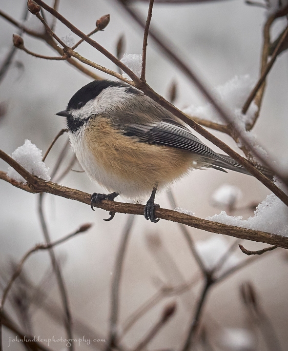 A chickadee pauses briefly between flights to our feeder
Morning Observation:
This morning in Huntington at 7:35AM it’s currently 22 degrees and snowing just a bit under cloudy skies. Winds are calm. Relative humidity is 93%, dewpoint 20, barometric pressure 30.24”. We picked up another 3.4″ of snow during the day yesterday and 1” overnight (storm total of 5.2”). We have 5” at the stake. Yesterday’s high was 28, and yesterday’s low was 21. The overnight low got down to 20.
This morning in North Hero it’s currently 24 degrees under cloudy skies. Winds are calm. Relative humidity is 89%, dewpoint 21, barometric pressure 30.32”. We picked up another 3” of snow during the day yesterday and have 6” at the stake (6” storm total). Yesterday’s high was 28, and yesterday’s low was 21. The overnight low got down to 21.
There is a High Wind Watch in effect for our region from 4:00PM Tuesday through 1:00PM Wednesday.
Forecast Discussion:
Aside from a few lingering morning snow showers over northern mountains, we should see a dry and seasonable day today with highs near 30 under mostly cloudy skies. Our attention next falls to a very potent storm system expected to impact the North Country Tuesday through Wednesday. An impressive mid-latitude cyclone is expected to deepen over the Mississippi River valley Tuesday and track into the Great Lakes through Wednesdays. It will lift a warm front into our region Tuesday afternoon followed by a sharp cold front on Wednesday. A round of heavy, wet snow is expected to kick things off later Tuesday afternoon into the evening. Snow totals are beginning to look impressive with 6″-10″ possible over far southern Vermont and 1″-4″ farther north before precipitation turns over to rain overnight. The main headline for this storm, however, is wind, and the NWS is not mincing words when they say that we can expect strong to damaging winds along the western slopes of the Greens. Wind gusts of 40-50 mph are likely with some gusts in the 65-75 mph range over higher summits (that’s near hurricane force!) So, batten down the hatches today folks and be prepared for widespread power outages. Adding to the wind impacts, we’ll also see a substantial amount of rain—0.75″-2″—during the day Wednesday as temperatures climb into the mid 40s. So, most of the lovely snow that’s on the ground right now is likely to melt and flow into our rivers. At this point, the NWWS is indicating that main stem rivers (Winooski, Lamoille, Otter Creek, etc.) are expected to crest later Wednesday night into Thursday but should remain within their banks. Fingers crossed… Colder air is expected to move in behind the departing storm system later Wednesday evening with a tad of follow up snow. Dry and seasonably mild conditions are expected for Thursday and Friday before another impactful and messy storm arrives Saturday into Sunday.
3-Day Forecast:
We’ll see mostly cloudy skies today with a 30% chance of morning snow showers. Highs will be near 29 with northwest winds 6-9 mph. Tonight should be mostly cloudy with a low around 18 and north winds around 6 mph becoming calm after midnight.
Tuesday should be mostly cloudy with a 30% chance of snow, mainly after 4:00PM. Highs will be near 37 with southeast winds increasing to 6-11 mph in the morning. Little or no snow accumulation expected. Tuesday night should be cloudy with snow before 11:00PM, transitioning to rain after midnight. Lows will be around 31 with southeast winds 24-29 mph increasing to 36-41 mph after midnight. Winds could gust as high as 60 mph. Chance of precipitation is 100% with snow accumulation of around 1″ possible.
Wednesday should be cloudy with rain. Highs will be near 46 with southeast winds 24-34 mph becoming southwesterly 11-21 mph. Winds could gust as high as 50 mph. Chance of precipitation is 100% with rainfall amounts between 0.25″-0.50″ possible. Wednesday night should be mostly cloudy with a 40% chance of rain before 8:00PM. Lows will be around 31 with southwest winds 14-17 mph gusting to 29 mph. Rainfall amounts of less than 0.10″ are possible.
Almanac:
Last year on this date in Huntington we had a high of 29 and a low of 16. We picked up 0.5″ of new snow and had 0.5″ at the stake.
Last year in North Hero we had a high of 30 and a lo low of 16.
Burlington averages for this date are a low of 14 and a high of 30.
The record low was -21 in 1968.
The record high was 63 in 2008 (we had a high of 58 in Huntington).
The Lake Champlain lake level in Burlington is 98.32′.
The water temperature is 38˚.
Last year’s lake level was at 97.21′.
The Mt. Mansfield snow stake depth is 20″.
The average depth for this date is 36″.
Mt. Washington Summit Conditions
Current Temperature: -1
Winds are out of the NW at 56 gusting to 64 mph
24 hr Precipitation: 7.8″ snow, 0.81″ melted precipitation
Visibility: less than 1/16 mile in blowing snow and freezing fog
Sky Notes:
Sunrise: 7:27AM
Sunset: 4:30PM
Length of day: 9:02:47
Today will be 1:16 longer than yesterday.
The Moon is a waning crescent, 26 days old with 12% illumination.
Moonrise: 4:50AM
Moonset: 1:24PM
About Today’s Photo:
Ah, chickadees. I could spend all day watching these wonderful little birds as they visit our feeder. As I’ve mentioned before, chickadees are my favorite songbird. Their plucky, gregarious nature is endearing. I’ve noticed an uptick in the number of birds of several species at the feeder now that snow is (briefly…) on the ground.
Sony A7II, Sigma 100-400mm lens @ 196mm, ISO 1250, f/6.3, 1/500″ exposure.
