Sunday, January 14, 2024
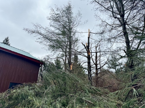 Snapped white pines behind our barn
Morning Observation:
This morning in Huntington at 7:30AM it’s currently 29 degrees under partly cloudy skies. Winds are calm. Relative humidity is 75%, dewpoint 22, barometric pressure 29.59”. We picked up 0.53” of rain yesterday and a 0.40” dusting of frozen sleet/snow. We have 4” of snow at the stake. Yesterday’s high was 43, and yesterday’s low was 32. The overnight low got down to 29.
This morning in North Hero it’s currently 30 degrees under partly cloudy skies. Winds are out of the south at 3-5 mph. Relative humidity is 85%, dewpoint 26, barometric pressure 29.61”. We picked up 0.31” of rain yesterday and have just a dusting of snow at the stake. Yesterday’s high was 41, and yesterday’s low was 27. The overnight low got down to 29.
So yesterday’s winds appear to have been much more damaging here in Huntington than the previous storm. We had a max gust of 43 mph around 8:30AM, and a couple of white pines behind our barn snapped and clipped the corner of the roof resulting in some broken trim. But there were reports from around the neighborhood of many fallen trees, trees across power lines, a house had its metal roof peeled off, and another had half its siding torn off. And of course the power is out again. As exciting as those storms were, I’m glad they’re behind us!
Forecast Discussion:
While it’s partly cloudy here now, morning radar imagery shows a potent band of lake effect snow showers streaming eastward off of Lake Ontario. These showers, reinforced by an approaching Arctic air boundary, are expected to move into Vermont later this afternoon, and the NWS has released a “Special Statement” warning of potential snow squalls between 11:00AM and 5:00PM. We could pick up a quick 1″-3″ of snow during these squalls with the possibility of white-out conditions as they come through. Quieter conditions are expected overnight and into Monday for Vermont with seasonably cool temperature and gusting southwest winds. A strong shortwave trough is expected to swing through the region on Tuesday bringing some widespread light snow yielding maybe 1″ of accumulation. An upper level low over Hudson Bay will be the main engine of our weather heading into midweek as it rotates colder air into the region and driving the occasional band of lake effect snow showers into Vermont through the end of the week. There’s an outside chance of a coastal low developing as we head into the weekend, but it’s too far out for any certainty at this time.
3-Day Forecast:
We’ll see mostly cloudy skies today with a 50% chance of snow showers, mainly after 10:0AM. The snow could be heavy at times. Highs will be near 30 with southwest winds 16-22 mph gusting to 36 mph. Total daytime snow accumulations of 1″-3″ are possible. Tonight should be mostly cloudy with a 30% chance of snow showers, mainly before 9:00PM. Lows will be around 15 with southwest winds 10-16 mph.
Monday should be mostly sunny with a high near 23 and southwest winds 10-13 mph. Monday night should be mostly cloudy with a low around 13 and south winds around 7 mph.
Tuesday should be cloudy with snow showers likely, mainly after 1:00PM. Highs will be near 23 with south winds 6-8 mph. Chance of precipitation is 60% with snow accumulations of around 1″ possible. Tuesday night should be mostly cloudy and chilly with a low around 7 and light and variable winds becoming westerly around 5 mph after midnight.
Almanac:
Last year on this date in Huntington we had a high of 23 and a low of 20. We picked up 0.80″ of new snow and had 1.5″ at the stake.
Last year in North Hero we had a high of 24 and a low of 21. We picked up 4″ of snow and had 4″ at the stake.
Burlington averages for this date are a low of 13 and a high of 29.
The record low was -25 in 1957.
The record high was 60 in 1995.
The Lake Champlain lake level in Burlington is 98.30′.
The water temperature is 39˚.
Last year’s lake level was at 97.31′
The Mt. Mansfield snow stake depth is 35″.
The average depth for this date is 39″.
Mt. Washington Summit Conditions
Current Temperature: 5
Winds are out of the west at 62 gusting to 73 mph
24 hr Precipitation: 9.9″ snow, 1.98″ melted precipitation
Visibility: less than 1/16 mile in freezing fog and blowing snow
Sky Notes:
Sunrise: 7:25AM
Sunset: 4:36PM
Length of day: 9:11:49
Today will be 1:39 longer than yesterday.
The Moon is a waxing crescent, 3 days old with 11% illumination.
Moonrise: 9:47AM
Moonset: 8:43PM
About Today’s Photo:
We got off a better than some of our neighbors during the wind storms, but we weren’t unscathed. Two of our pines snapped off clipping the corner of the barn and causing some minor damage, and there are several other branches down around our property. It’ll be chainsaw work for me today as we clean up.
iPhone 15 Pro

Bummer, hope the damage is not too bad. We actually held on to our power this round and n more trees down that we can see. Good luck with the pine trees 😦
January 14, 2024 at 9:21 am
It’s interesting, because
Tuesday night was much more severe on our part of Ross Hill than the winds on Saturday morning. Tuesday night was just purely terrifying! Glad everyone is okay.
January 14, 2024 at 6:52 pm
Thanks Evergreen. Yes, I think the winds were a bit stronger in Tuesday’s storm, but it was something about their motion on Saturday that impacted other areas.
January 15, 2024 at 7:03 am