Thursday, May 16, 2024

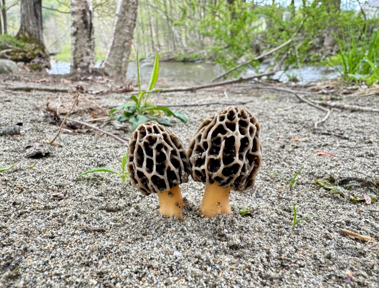 A lovely pair of morel mushrooms in an undisclosed location
Morning Observation:
This morning in North Hero at 7:00AM it’s currently 60 degrees under mostly cloudy skies. Winds are calm. Relative humidity is 97%, dewpoint 59, barometric pressure 29.84”. Yesterday’s high was 65, and yesterday’s low was 55. The overnight low got down to 57.
This morning in Huntington it’s currently 56 degrees under cloudy skies. Winds are calm. Relative humidity is 98%, dewpoint 55, barometric pressure 29.84”. We picked up 0.02” of rain yesterday and 0.01” so far today. Yesterday’s high was 67, and yesterday’s low was 53. The overnight low got down to 54.
Forecast Discussion:
Morning radar imagery shows an area of low pressure stalled off the coast of Long Island. The low will continue to rotate moisture back into Vermont through the day today bringing spotty showers to the region. Drier air will move in later tonight as a ridge of high pressure begins to move in bringing party sunny skies with highs in the mid to upper 70s for Friday. Another round of showers is expected to move through later Friday night into Saturday as a shortwave trough slides through. Dry conditions return for Sunday along with a significant warming trend arriving early next week and into middle of the week.
3-Day Forecast:
We’ll see partly sunny skies today with a 30% chance of afternoon showers. Highs will be near 72 with calm winds becoming southwesterly 5-7 mph in the afternoon. Tonight should be partly cloudy with a low around 52 with south winds 5-10 mph.
Friday should be partly sunny with a high near 75 and south winds around 6 mph. Friday night should be mostly cloudy with a 30% chance of showers. Lows around 56 and south winds around 7 mph.
Saturday should be partly sunny with a 30% chance of showers. Highs will be near 73 with south winds around 7 mph. Saturday night should be partly cloudy with a low around 52 and south winds around 5 mph.
Almanac:
Last year on this date in Huntington we had a high of 71 and a low of 40. We picked up 0.01″ of rain.
Last year in North Hero we had a high of 69 and a low of 41. We picked up 0.03″ of rain.
Burlington averages for this date are a low of 48 and a high of 69.
The record low was 29 in 1987.
The record high was 87 in 1991.
The Lake Champlain lake level in Burlington is 97.30′.
The water temperature is 53˚.
Last year’s lake level was at 97.71′.
The Mt. Mansfield snow stake depth is 16″.
The average depth for this date is 22″.
Mt. Washington Summit Conditions
Current Temperature: 40˚
Winds are out of the SE 26-29 mph
24 hr Precipitation: 0.46″ rain
Visibility: less than 1/16 mile in fog
Sky Notes:
Sunrise: 5:23AM
Sunset: 8:14PM
Length of day: 14:50:43
Today will be 2:09 longer than yesterday.
The Moon is waxing gibbous, 8 days old with 57% illumination.
Moonrise: 2:00PM
Moonset: 3:04AM
About Today’s Photo:
I came across these lovely morel mushrooms while walking with a friend in an undisclosed location. Mums the word…
iPhone 15 Pro
Wednesday, May 15, 2024

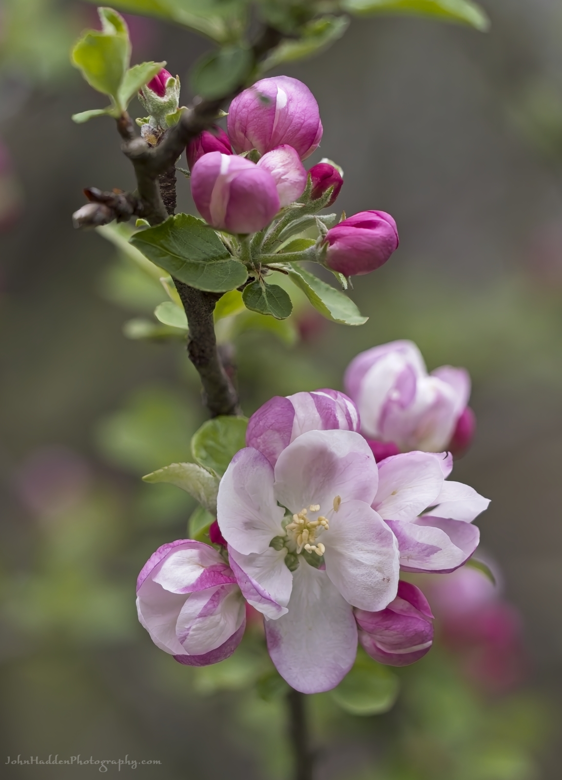
Apple blossoms blooming
Morning Observation:
This morning in North Hero at 6:50AM it’s currently 56 degrees under mostly cloudy skies. Winds are calm. Relative humidity is 96%, dewpoint 55, barometric pressure 29.84”. We picked up 0.12” of rain yesterday. Yesterday’s high was 69, and yesterday’s low was 52. The overnight low got down to 55.
This morning in Huntington it’s currently 54 degrees under mostly cloudy skies. Winds are calm. Relative humidity is 98%, dewpoint 54, barometric pressure 29.84”. We picked up 0.76” of rain yesterday. Yesterday’s high was 77, and yesterday’s low was 55. The overnight low got down to 53.
Forecast Discussion:
Morning radar imagery shows an area of showers pushing into southern Vermont at this hour at the edge of a stubborn cold frontal boundary. This boundary is expected to push northward today into Vermont bringing showers to the region today and lingering into Thursday before the front finally drops south of the region taking showers with it. High pressure is expected to build in later Thursday night and into Friday bringing dry and seasonably warm conditions for Friday with highs in the mid 70s and partly sunny skies. Previous forecasts had called for a wetter weekend, but models are now indicating that we should see a mostly dry weekend with seasonally warm temperatures.
3-Day Forecast:
We’ll see cloudy skies today with showers. Highs will be near 68 with southwest winds 5-10 mph. Chance of precipitation is 90% with rainfall amounts between 0.10″-0.25″ possible. Tonight should be cloudy with showers likely. Lows will be around 53 with south winds 5-10 mph. Chance of precipitation is 60% with rainfall amounts of less than 0.10″ possible.
Thursday should be partly sunny with a 50% chance of showers. Highs will be near 73 with south winds around 7 mph. Rainfall amounts of less than 0.10″ are possible. Thursday night should be partly cloudy with a low around 52 and light south winds.
Friday should be partly sunny with a high near 76 and south winds 3-7 mph. Friday night should be mostly cloudy with a low around 56 and southeast winds 6-8 mph.
Almanac:
Last year on this date in Huntington we had a high of 71 and a low of 33.
Last year in North Hero we had a high of 68 and a low of 49.
Burlington averages for this date are a low of 48 and a high of 69.
The record low was 29 in 1971.
The record high was 88 in 1961.
The Lake Champlain lake level in Burlington is 97.33′.
The water temperature is 50˚.
Last year’s lake level was at 97.77′.
The Mt. Mansfield snow stake depth is 18″.
The average depth for this date is 24″
(The Smugglers Notch Road was opened yesterday.)
Mt. Washington Summit Conditions
Current Temperature: 48˚
Winds are out of the SE at 3-7 mph
24 hr Precipitation: 0.06″ rain
Visibility: around 40 miles under partly cloudy skies.
Sky Notes:
Sunrise: 5:24AM
Sunset: 8:12PM
Length of day: 14:48:33
Today will be 2:12 longer than yesterday.
The Moon is in its first quarter, 7 days old with 48% illumination.
Moonrise: 12:58PM
Moonset: 2:42AM
About Today’s Photo:
Apple blossoms are popping on many of the wild apple trees we have around our place in Huntington. Looks like it’ll be a bumper year for apples!
Panasonic GX8, Olympus 60mm macro lens, ISO 800, f/2.8, 1/1300″ exposure
Tuesday, May 14, 2024

 Marsh marigold flowering down by Fargo Brook
Morning Observation:
This morning in North Hero at 7:00AM it’s currently 54 degrees and raining under overcast skies. Winds are out of the south at 7-10 mph. Relative humidity is 95%, dewpoint 53, barometric pressure 29.86”. We picked up 0.02” of rain yesterday and 0.12” so far today. Yesterday’s high was 60, and yesterday’s low was 50. The overnight low got down to 52.
This morning in Huntington it’s currently 57 degrees under cloudy skies. Winds are calm. Relative humidity is 95%, dewpoint 56, barometric pressure 29.88”. We picked up 0.04” yesterday and 0.27” so far today. Yesterday’s high was 70, and yesterday’s low was 44. The overnight low got down to 55.
Forecast Discussion:
Morning radar imagery shows an area of low pressure just north of Montreal at this hour with a warm front draped just north of the International border. This front is expected to sag southward during the day today bringing showers and thunderstorms to the region for most of the day today. Highs today will top out in the mid 70s perhaps even hitting 80s over southern areas. Most thunderstorm activity will wind down overnight as instability decreases, but showers are expected to persist through tonight and into Wednesday. A stalling frontal boundary over the region and an upper low closing off over the eastern seaboard will be bring more unsettled conditions Thursday with showers expected. Dry conditions are expected later Thursday night through Friday as a ridge of high pressure builds in briefly. Unsettled conditions will be the rule heading into the weekend as another frontal boundary swings through on Saturday bringing more showers.
3-Day Forecast:
We’ll see cloudy skies today with showers and possibly a thunderstorm after 2:00PM. Highs will be near 76 with south winds 8-16 mph. Chance of precipitation is 80% with rainfall amounts between 0.10″-0.25″ with higher amounts possible in thunderstorms. Tonight should be cloudy with showers and thunderstorms likely. Lows will be around 57 with south winds 5-7 mph becoming calm in the evening. Chance of precipitation is 60% with rainfall amounts between 0.10″-0.25″ possible with higher amounts possible in thunderstorms.
Wednesday should be cloudy with showers. Highs will be near 71 with south winds 3-5 mph. Chance of precipitation is 80% with rainfall amounts between 0.10″-0.25″ possible. Wednesday night should be mostly cloudy with showers likely, mainly before 7:00PM. Lows will be around 55 with calm winds. Chance of precipitation is 60% with rainfall amounts of less than 0.10″ possible.
Thursday should be mostly cloudy with a 40% chance of showers. Highs will be near 70 with calm winds becoming northerly around 5 mph in the afternoon. Rainfall amounts of less than 0.10″ are possible. Thursday night should be mostly cloudy with a low around 54 and southeast winds 3-5 mph.
Almanac:
Last year on this date in Huntington we had a high of 60 and a low of 32 (brrr!)
Last year in North Hero we had a high of 64 and a low of 44.
Burlington averages for this date are a low of 47 and a high of 69.
The record high was 30 in 1967.
The record high was 88 in 2022 (we had a high of 87 in Huntington).
The Lake Champlain lake level in Burlington is 97.35′.
The water temperature is 50˚.
Last year’s lake level was at 97.90′.
The Mt. Mansfield snow stake depth is 19″.
The average depth for this date is 26″.
Mt. Washington Summit Conditions
Current Temperature: 41˚
Winds are out of the SW at 31 gusting to 43 mph
24 hr Precipitation: 0
Visibility: around 60 miles under partly cloudy skies.
Sky Notes:
Sunrise: 5:25AM
Sunset: 8:11PM
Length of day: 14:46:21
Today will be 2:14 longer than yesterday.
The Moon is a waxing crescent, 6.3 day old with 38% illumination.
Moonrise: 11:53AM
Moonset: 2:15AM
About Today’s Photo:
Marsh marigold is blooming prolifically this time of year, and you’ll see its bright yellow flowers along streams and wetlands. I’m not sure what’s causing the the white spots on the petals in the photo, but perhaps some insect has been at work…
Panasonic GX8, Olympus 60mm macro lens, ISO 800, f/2.8, 1/1300″ exposure
Monday, May 13, 2024
 Amelanchier in bloom along East Street
Morning Observation:
This morning in Huntington at 7:20AM it’s currently 47 degrees under mostly sunny skies. Winds are calm. Relative humidity is 97%, dewpoint 49, barometric pressure 30.00”. We picked up 0.01” of rain yesterday. Yesterday’s high was 57, and yesterday’s low was 45. The overnight low got down to 44.
This morning in North Hero it’s currently 52 degrees under mostly sunny skies. Winds are out of the south at 5-8 mph. Relative humidity 90%, dewpoint 49, barometric pressure 29.98”. We picked up 0.06” of rain yesterday. Yesterday’s high was 56, and yesterday’s low was 49. The overnight low got down to 50.
Forecast Discussion:
Unsettled conditions will be the rule for the next couple of days as low pressure to our north swings a warm front through the region later this afternoon. More showers and some thunderstorms will arrive on Tuesday afternoon into Tuesday night as another low passes to our south. Showers will linger into Wednesday. Generally unsettled conditions will persist into later this week.
3-Day Forecast:
We’ll see partly sunny skies today with a 30% chance of showers, mainly after 5:00PM. Highs will be near 67 with south winds 5-10 mph. Tonight should be cloudy with showers. Lows will be around 54 with south winds around 14 mph. Chance of precipitation is 80% with rainfall amounts between 0.10″-0.25″ possible.
Tuesday should be mostly cloudy with showers and thunderstorms likely. Highs will be near 73 with south winds 9-11 mph. Chance of precipitation is 80% with rainfall amounts between 0.50”-0.75” possible. Tuesday night should be cloudy with showers. Lows will be around 57 with south winds around 6 mph. Chance of precipitation is 80% with rainfall amounts between 0.50”-0.75” possible.
Wednesday should be mostly cloudy with showers likely, mainly before 2:00PM. Highs will be near 68 with south winds around 6 mph becoming calm. Chance of precipitation is 60% with rainfall amounts between 0.10″-0.25″ possible. Wednesday night should be mostly cloudy with a 30% chance of showers. Lows will be around 50 with light northeast winds.
Almanac:
Last year on this date in Huntington we had a high of 71 and a low of 42.
Last year in North Hero we had a high of 71 and a low of 50.
Burlington averages for this date are a low of 47 and a high of 68.
The record low was 30 in 2010 (we had a low of 27 in Huntington).
The record high was 88 in 2022 (we had a high of 88 in Huntington).
The Lake Champlain lake level in Burlington is 97.44′.
The water temperature is 50˚.
Last year’s lake level was at 98.04′.
The Mt. Mansfield snow stake depth is 19″.
The average depth for this date is 28″.
Mt. Washington Summit Conditions
Current Temperature: 32˚
Winds are out of the SW at 2-4 mph
24 hr Precipitation: 0
Visibility: around 80 miles under mostly sunny skies
Sky Notes:
Sunrise: 5:26AM
Sunset: 8:10PM
Length of day: 14:44:07
Today will be 2:16 longer than yesterday.
The Moon is a waxing crescent, 5.3 days old with 29% illumination.
Moonrise: 10:47AM
Moonset: 1:41AM
About Today’s Photo:
Amelanchier (aka Servicebury, shadberry, shadblow) is in bloom in the woods now. This is an early flowering tree that stands out brightly against the greening background of spring foliage.
Panasonic GX8, Olympus 60mm macro lens, ISO 800, f/8, 1/500″ exposure
Friday, May 10, 2024

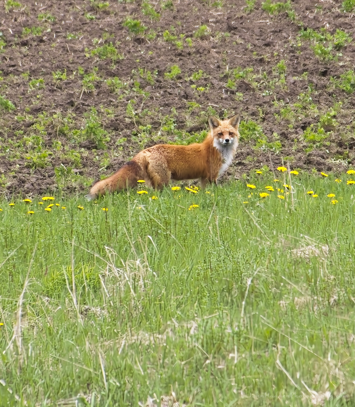 A fine looking fox in the lower village yesterday afternoon
Morning Observation:
This morning in Huntington at 7:50AM it’s currently 51 degrees under partly cloudy skies. Winds are calm. Relative humidity is 85%, dewpoint 47, barometric pressure 29.82”. Yesterday’s high was 60, and yesterday’s low was 43. The overnight low got down to 41.
This morning in North Hero it’s currently 52 degrees under partly cloudy skies. Winds are calm. Relative humidity is 86%, dewpoint 49, barometric pressure 29.83”. Yesterday’s high was 61, and yesterday’s low was 47. The overnight low got down to 46.
Forecast Discussion:
Morning radar imagery shows a broad area of low pressure approaching the mid-Atlantic coast at this hour with showers pushing through western New York as well as off the coast around Long Island and Cape Cod. Most of the heavy precipitation is expected to remain south of Vermont today, but we will likely still see some “popcorn” type showers over much of the region today as diurnal heating gets to work. Precipitation should wind down this evening, but a shortwave trough is expected to approach the region overnight tonight bringing more showers to northern New York Saturday while most of Vermont stays largely dry. Another trough of low pressure will track out of the Great Lakes and into the mid-Atlantic region on Sunday bringing renewed showers to Vermont on Sunday. Temperatures through the weekend will be on the cool side of seasonable with daytime highs in the upper 50s and overnight lows in the upper 30s to mid 40s. Unsettled conditions will persist into the middle of next week as temperatures warm back to more seasonable levels.
3-Day Forecast:
We’ll see mostly cloudy skies today with a 30% chance of showers this afternoon. Highs will be near 62 with light and variable winds. Rainfall amounts of less than 0.10″ are possible. Tonight should be mostly cloudy with a 30% chance of showers, mainly before 7:00PM. Lows will be around 44 with southeast winds 3-5 mph. Rainfall amounts of less than 0.10″ are possible.
Saturday should be partly sunny with a 30% chance of afternoon showers. Highs will be near 61 with southeast winds 3-5 mph. Rainfall amounts of less than 0.10″ are possible. Saturday night should be mostly cloudy with a low around 44 and southeast winds around 7 mph.
Sunday should be mostly cloudy with a 50% chance of showers. Highs will be near 55 with southeast wind around 7 mph. Rainfall amounts of less than 0.10″ are possible. Sunday night should be mostly cloudy with a low around 43 and south winds around 6 mph.
Almanac:
Last year on this date in Huntington we had a high of 73 and a low of 32.
Last year in North Hero we had a high of 72 and a low of 46.
Burlington averages for this date are a low of 46 and a high of 67.
The record low was 25 in 1947.
The record high was 89 in 2007 (we had a high of 87 in Huntington).
The Lake Champlain lake level in Burlington is 97.65′.
The water temperature is 43˚.
Last year’s lake level was at 98.31′.
The Mt. Mansfield snow stake depth is 26″.
The average depth for this date is 34″.
Mt. Washington Summit Conditions
Current Temperature: 24˚
Winds are out of the NE at 13-18 mph
24 hr Precipitation: 1″ snow, 0.27″ melted precipitation
Visibility: around 90 miles under partly cloudy skies.
Sky Notes:
Sunrise: 5:30AM
Sunset: 8:07PM
Length of day: 14:37:09
Today will be 2:23 longer than yesterday.
The Moon is a waxing crescent, 2.4 days old with 6% illumination.
Moonrise: 6:52AM
Moonset: 11:43PM
About Today’s Photo:
I was driving into Huntington’s lower village yesterday afternoon contemplating taking a shot of the greening hillsides and recently planted rows of veggies, when I suddenly spied this beautiful fox trotting across the field. Luckily I had my camera with its telephoto lens already in place sitting on the seat next to me, so I was able to get this shot. It certainly looks like a healthy animal with its lush red coat and magnificent bushy tail!
Panasonic GX8, Lumix 100-300mm lens @ 300mm, ISO 800, f/8, 1/500″ exposure
Thursday, May 9, 2024

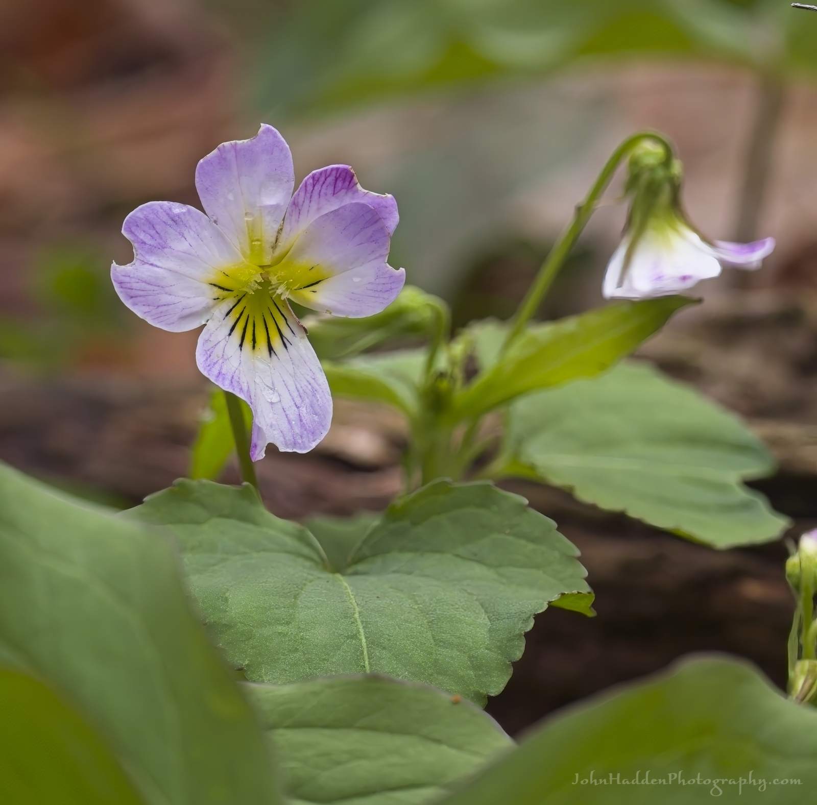 Canada violets blooming at Pelots Nature Area
Morning Observation:
This morning in Huntington at 8:00AM it’s currently 45 degrees under mostly cloudy skies. Winds are calm. Relative humidity is 95%, dewpoint 44, barometric pressure 29.77”. We picked up 0.18” of rain yesterday. Yesterday’s high was 71, and yesterday’s low was 42. The overnight low got down to 45.
This morning in North Hero it’s currently 55 degrees under mostly clear skies. Winds are calm. Relative humidity is 74%, dewpoint 47, barometric pressure 29.79”. We picked up 0.29” of rain yesterday. Yesterday’s high was 56, and yesterday’s low was 47. The overnight low got down to 47.
Forecast Discussion:
We’ve got a mostly dry albeit seasonably cool day on tap for today as we sit between yesterday’s departing system and the next system currently pushing into the western Great Lakes. Highs today will top out in the upper 50s to low 60s under mostly cloudy skies. Chances for showers will be on the increase late tonight into Friday as low pressure tracks to our south. The bulk of this system’s precipitation is expected to stay to our south, but we should still see some widely scattered showers Friday and into the weekend as the system swings up and off the Atlantic coast through the weekend rotating moisture back into the region. No washouts are expected precipitation-wise through the weekend, but temperatures are expected to remain on the cool side through the period. Unsettled, cool, and generally showery conditions will persist into next week as a zonal flow aloft moves a series of troughs across the region into midweek.
3-Day Forecast:
We’ll see mostly cloudy skies today with a high near 58 and north winds around 7 mph. Tonight should be mostly cloudy with 20% chance of showers before. Lows will be around 42 with north winds around 6 mph becoming easterly after midnight.
Friday should be mostly cloudy with a 30% chance of showers, mainly in the afternoon. Highs will be near 59 with calm winds becoming northerly around 5 mph in the afternoon. Rainfall amounts of less than 0.10″ are possible. Friday night should be mostly cloudy with a 30% chance of showers between. Lows will be around 44 with light and variable winds. Rainfall amounts of less than 0.10″ are possible.
Saturday should be partly sunny with a 40% chance of afternoon showers. Highs will be near 61 with southeast winds around 7 mph. Rainfall amounts of less than 0.10″ are possible. Saturday night should be mostly cloudy with a 40% chance of showers. Lows will be around 44 with southeast winds around 7 mph. Rainfall amounts of less than 0.10″ are possible.
Almanac:
Last year on this date in Huntington we had a high of 60 and a low of 30.
Last year in North Hero we had a high of 61 and a low of 43.
Burlington averages for this date are a low of 46 and a high of 67.
The record low was 28 in 1985.
The record high was 92 in 1979.
The Lake Champlain lake level in Burlington is 97.72′.
The water temperature is 46˚.
Last year’s lake level was at 98.38′.
The Mt. Mansfield snow stake depth is 27″.
The average depth for this date is 35″.
Mt. Washington Summit Conditions
Current Temperature: 29˚
Winds are out of the north at 35-38 mph
24 hr Precipitation: 0.79″ rain
Visibility: about 1/16 mile in freezing fog
Sky Notes:
Sunrise: 5:31AM
Sunset: 8:06PM
Length of day: 14:34:46
Today will be 2:25 longer than yesterday.
The Moon is a waxing crescent, 1.3 days old with 2% illumination.
Moonrise: 6:06AM
Moonset: 10:35PM
About Today’s Photo:
Canada violets wildflowers are native and range from Alaska to Newfoundland and as far south at Georgia and Arizona. They literally “stand out” as one of the tallest species of native violets standing 6″-8″ tall.
Panasonic GX8, Olympus 60mm macro lens, ISO 800, f/8, 1/160″ exposure
Wednesday, May 8, 2024

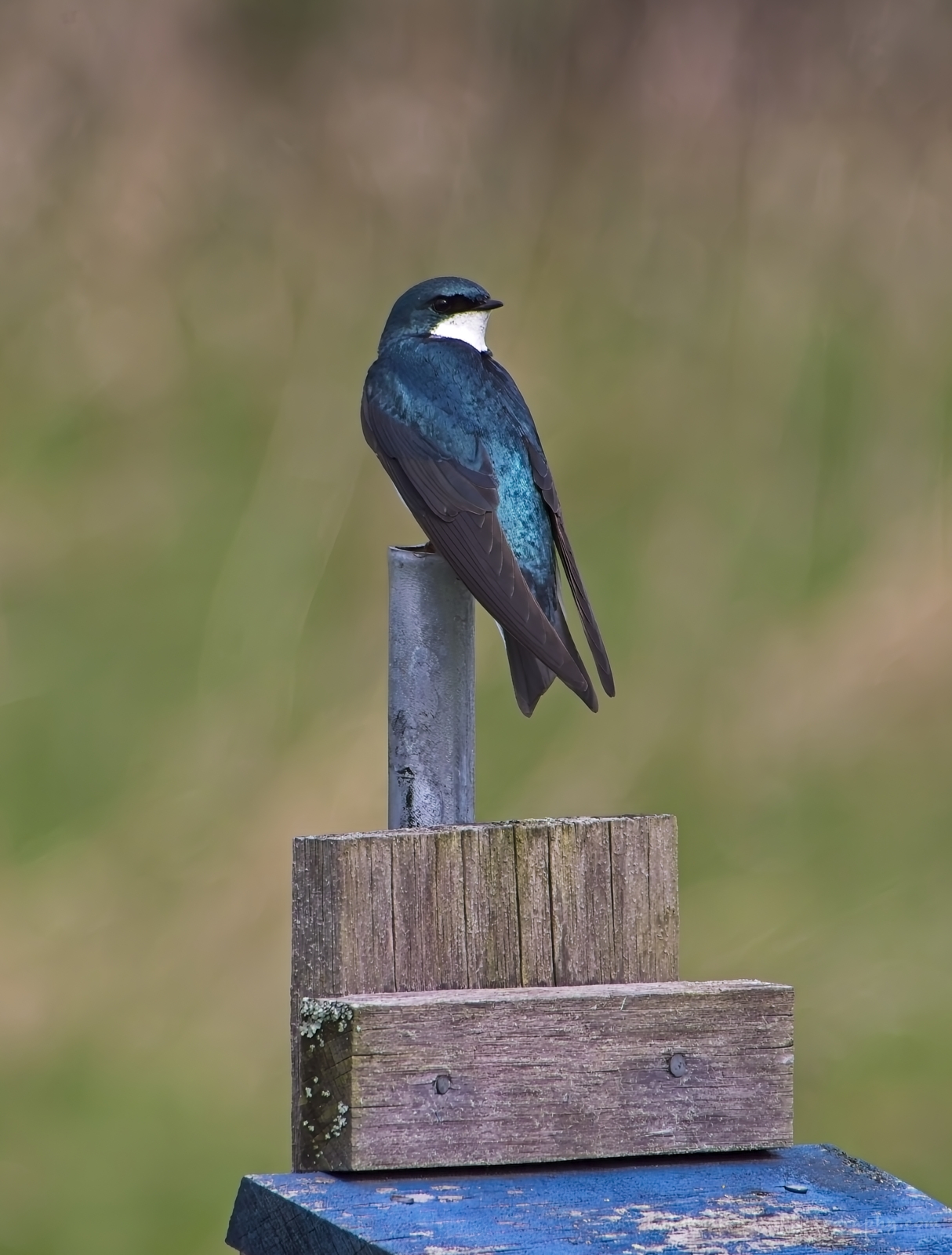 A tree swallow stakes out one of the nesting boxes at Pelots Nature Area
Morning Observation:
This morning in North Hero at 6:45AM it’s currently 51 degrees under cloudy skies. Winds are calm. relative humidity is 79%, dewpoint 44, barometric pressure 29.65”. Yesterday’s high was 71, and yesterday’s low was 49. The overnight low got down to 49.
This morning in Huntington it’s currently 46 degrees under cloudy skies. Winds are calm. Relative humidity is 96%, dewpoint 45, barometric pressure 29.62”. Yesterday’s high was 71, and yesterday’s low was 41. The overnight low got down to 42.
Forecast Discussion:
Morning radar imagery shows low pressure over Lake Huron at this hour with a band a showers and thunderstorms lifting along a warm front just west of Vermont. Precipitation will push into Vermont by midmorning and may become heavy at times during thunderstorms. A dry slot is expected to move through the region midday or so, but precipitation is expected to pick back up later this afternoon with some thunderstorms approaching severe levels over southern/central region, especially if the dry slot brings any sunshine thereby increasing instability. The aforementioned low will drift over the region tonight with showers coming to an end west to east. Cloudy and generally cool conditions are expected for Thursday with highs only in the in 50s. Another low pressure system is expected to pass to our south Thursday night into Friday with unsettled, cool conditions expected Friday and into the weekend. Another low is expected to move through the region Sunday bringing higher chances for showers Sunday.
3-Day Forecast:
We’ll see cloudy skies today with showers this morning and thunderstorms possible this afternoon. Highs will be near 64 with southeast winds 5-13 mph. Chance of precipitation is 80% with rainfall amounts between 0.25″-0.50″ possible. Tonight should be cloudy with showers likely and possibly a thunderstorm before 8:00PM, then a chance of showers and patchy drizzle. Lows will be around 46 with northwest winds 6-8 mph. Chance of precipitation is 60% with rainfall amounts between 0.10″-0.25″ with higher amounts possible in thunderstorms.
Thursday should be cloudy with a 30% chance of showers, mainly in the afternoon. Highs will be near 58 with north winds around 5 mph. Rainfall amounts of less than 0.10″ are possible. Thursday night should be cloudy with a 30% chance of rain. Lows will be around 45 with east winds 5-7 mph. Rainfall amounts of less than 0.10″ are possible.
Friday should be mostly cloudy with a 40% chance of rain. Highs will be near 55 with southeast winds 3-6 mph. Rainfall amounts of less than 0.10″ are possible. Friday night should be mostly cloudy with a 40% chance of showers. Lows will be around 41 with light southeast winds. Rainfall amounts of less than 0.10″ are possible.
Almanac:
Last year on this date in Huntington we had a high of 63 and a low of 36.
Last year in North Hero we had a high of 66 and a low of 49.
Burlington averages for this date are a low of 45 and a high of 67.
The record low was 25 in 1962.
The record high was 88 in 2015 (we had a high of 86 in Huntington).
The Lake Champlain lake level in Burlington is 97.71′.
The water temperature is 44˚.
Last year’s lake level was at 98.47′.
The Mt. Mansfield snow stake depth is 29″.
The average depth for this date is 37″.
Mt. Washington Summit Conditions
Current Temperature: 39˚
Winds are out of the south at 15-19 mph.
24 hr Precipitation: 0
Visibility: around 80 mile under cloudy skies.
Sky Notes:
Sunrise: 5:32AM
Sunset: 8:04PM
Length of day: 14:32:20
Today will be 2:27 longer than yesterday.
The Moon is a waxing crescent, 0.5 days old with 1% illumination.
Moonrise: 5:30AM
Moonset: 9:18PM
About Today’s Photo:
There was quite a lot of activity around the nesting boxes in the fields at Pelots Nature Area with several tree swallows diving and swooping around competing for nesting space. This lovely iridescent fellow kept an eye on me as I snapped his portrait.
Panasonic GX8, Lumix 100-300mm lens @ 300mm, ISO 800, f/8, 1/1300″ exposure
Tuesday, May 7, 2024

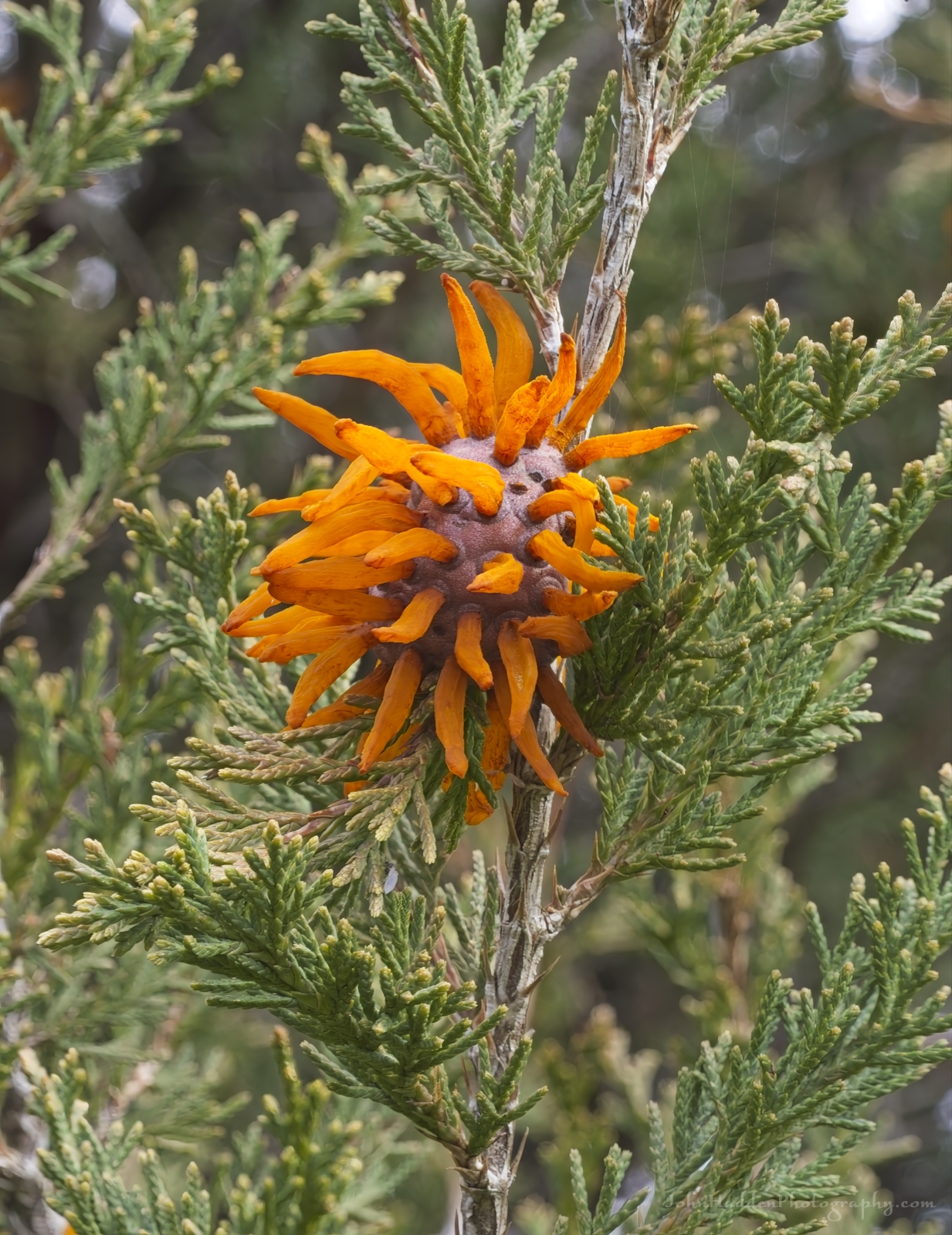 What’s this in the cedar tree? Alien invasion???
Morning Observation:
This morning in Huntington at 6:40AM it’s currently 41 degrees under clear skies. Winds are calm. Relative humidity is 97%, dewpoint 41, barometric pressure 29.86”. We picked up 0.17” of rain yesterday. Yesterday’s high was 75, and yesterday’s low was 49. The overnight low got down to 41.
This morning in North Hero it’s currently 52 degrees under clear skies. Winds are calm. Relative humidity is 79%, dewpoint 46, barometric pressure 29.86”. Yesterday’s high was 66, and yesterday’s low was 49.
Forecast Discussion:
We’ve got a lovely spring day on tap for today courtesy of high pressure cresting over the region. Highs today will top out in the upper 60s to mid 70s under sunny skies. Clouds will be on the increase overnight tonight out ahead of our next storm system. We’ll be caught in the interplay between an upper low centered near the Canadian Maritimes and another low approaching from the Great Lakes. A shortwave trough is expected to break off the western low and wrap around the eastern trough, swinging directly across our region during the day Wednesday. Widespread showers are expected starting Wednesday morning, becoming heavy at times, with some thunderstorms possible over central and southern areas of Vermont. A trailing cold front will cross the region Wednesday night as showers wind down overnight. A weak ridge of high pressure is expected to push down from Canada early Thursday, and we might see some glimpse of sun. However, another low pressure system will be sliding through to our south which will push showers back into the region later Thursday into Friday. Unsettled and generally cooler conditions will continue into the upcoming weekend.
3-Day Forecast:
We’ll see sunny skies today with a high near 70 and northwest winds 5-9 mph. Tonight should be partly cloudy with a low around 47 and north winds around 5 mph becoming calm in the evening.
Wednesday should be cloudy with showers. Highs will be near 61 with south winds 8-14 mph. Chance of precipitation is 80% with rainfall amounts between 0.25″-0.50″ possible. Wednesday night should be cloudy with showers. Lows will be around 44 with southwest winds 6-8 mph becoming northwesterly in the evening. Chance of precipitation is 60% with rainfall amounts of less than 0.10″ possible.
Thursday should be cloudy with a 50% chance of afternoon showers. Highs will be near 59 with north winds 3-6 mph. Rainfall amounts of less than 0.10″ are possible. Thursday night should be cloudy with rain likely. Lows will be around 44 with east winds 3-6 mph. Chance of precipitation is 70% with rainfall amounts between 0.10″-0.25″ possible.
Almanac:
Last year on this date in Huntington we had a high of 75 and a low of 39.
Last year in North Hero we had a high of 74 and a low of 51.
Burlington averages for this date are a low of 66 and a low of 45.
The record low was 25 in 1968.
The record high was 89 in 2000 (we had a high of 85 in Huntington).
The Lake Champlain lake level in Burlington is 97.76′.
The water temperature is 45˚.
Last year’s lake level was at 98.59′.
The Mt. Mansfield snow stake depth is 30″.
The average depth for this date is 38″.
Mt. Washington Summit Conditions
Current Temperature: 32˚
Winds are out of the NW at 44-46 mph
24 hr Precipitation: 0.1″
Visibility: around 100 miles under clear skies.
Sky Notes:
Sunrise: 5:33AM
Sunset: 8:03PM
Length of day: 14:29:53
today will be 2:29 longer than yesterday.
The Moon is new, 28.6 days old with 0% illumination.
Moonrise: 5:02AM
Moonset: 7:56PM
About Today’s Photo:
I came across many hundreds of these strange growths on the red cedars in the Middle Meadow of Pelots Nature Area the other day. They festooned the trees like bizarre Christmas ornaments. Turns out they are cedar-apple rust. In any location where apples or crabapples and eastern red cedar coexist (like the Middle Meadow), cedar-apple rust can be a destructive or disfiguring disease on both the apples and cedars. Cedar-apple rust is caused by the fungi Gymnosporangium that spend part of their life cycles on Eastern red cedars growing near orchards. The complex disease cycle alternates between the two host plants. It’s really quite fascinating. You can read all about here. They sure look creepy!
Panasonic GX8, Olympus 60mm macro lens, ISO 800, f/11, 1/50″ exposure
Monday, May 6, 2024

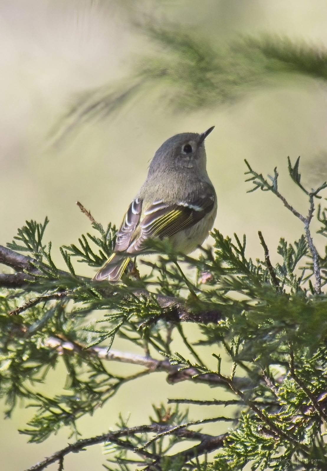 A ruby-crowned kinglet hunts in the cedars at Pelots Nature Area
Morning Observation:
This morning in Huntington at 7:00AM it’s currently 52 degrees and raining lightly under overcast skies. Winds are calm. Relative humidity is 96%, dewpoint 51, barometric pressure 29.97”. We picked up 0.36” of rain yesterday. Yesterday’s high was 56, and yesterday’s low was 49. The overnight low got down to 52.
This morning in North Hero it’s currently 50 degrees under cloudy skies. Winds are out of the south at 4-6 mph. Relative humidity is 97%, dewpoint 49, barometric pressure 29.97”. We picked up 0.16” of rain yesterday. Yesterday’s high was 55, and yesterday’s low was 48.
Forecast Discussion:
Morning radar imagery shows an area of showers pushing into Vermont at this hour. Showers are expected to wind down this morning with skies beginning to clear by this afternoon as daytime highs rise into the 60s to low 70s. High pressure building into the region tonight will deliver another lovely spring day on Tuesday with mostly sunny skies and highs in the uppers 60s and low 70s. Low pressure tracking out of the Great Lakes Tuesday night will bring widespread showers later Tuesday night through Wednesday. Thursday should start out dry with showers arriving in the afternoon as another low pushes through to our south. Showers will continue into Friday. Unsettled and generally cool conditions will persist into the weekend.
3-Day Forecast:
We’ll see cloudy skies this morning with scattered showers, mainly before 11:00AM. Skies should gradually clear this afternoon with a highs near 71 and south winds around 6 mph becoming northwesterly in the afternoon. Chance of precipitation is 40% with rainfall amounts of less than 0.10″ possible. Tonight should be mostly clear with a low around 45 and light northwest winds.
Tuesday should be sunny with a high near 71 and northwest winds 5-8 mph. Tuesday night should be partly cloudy with a 40% chance of showers. Lows will be around 47 with northeast winds around 5 mph becoming calm in the evening. Rainfall amounts of less than 0.10″ are possible.
Wednesday should be cloudy with showers. Highs will be near 60 with southeast winds around 6 mph. Chance of precipitation is 90% with rainfall amounts between 0.25″-0.50″ possible. Wednesday night should be mostly cloudy with a 40% chance of showers. Lows will be around 45 with northwest winds 3-6 mph. Rainfall amounts of less than 0.10″ are possible.
Almanac:
Last year on this date in Huntington we had a high of 71 and a low of 36.
Last year in North Hero we had a high of 72 and a low of 47.
Burlington averages for this date are a low of 44 and a high of 66.
The record low was 25 in 1961.
The record high was 87 in 1944.
The Lake Champlain lake level in Burlington is 97.72′.
The water temperature is 46˚.
Last year’s lake level was at 98.62′.
The Mt. Mansfield snow stake depth is 33″.
The average depth for this date is 40″.
Mt. Washington Summit Conditions
Current Temperature: 41˚
Winds are out of the west at 41-44 mph
24 hr Precipitation: 0.57″ rain
Visibility: less than 1/16 mile in drizzle and fog
Sky Notes:
Sunrise: 5:35AM
Sunset: 8:02PM
Length of day: 14:27:24
Today will be 2:31 longer than yesterday.
The Moon is a waning crescent, 27 days old with 4% illumination.
Moonrise: 4:37AM
Moonset: 6:33PM
About Today’s Photo:
As I walked through the meadows at Pelots Nature Area the other morning, there was a herd of birds ahead of me hunting in the cedars along the meadow edge. Chickadees and a bunch of white throated sparrows were the primary birds, but I managed to get a show of this ruby-crowned kinglet as it hunted in the cedars.
Panasonic GX8, Lumix 100-300mm lens @ 300mm, ISO 800, f/5.6, 1/800″ exposure
Sunday, May 5, 2024

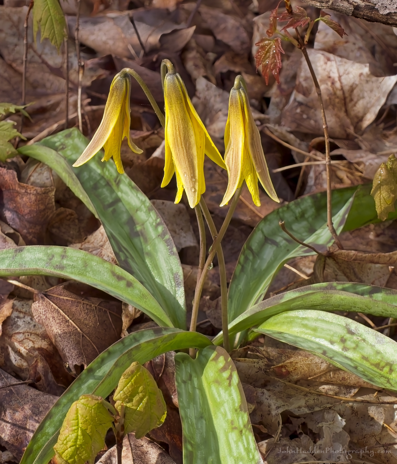 A trio of trout lilies at Pelots Nature Area
Morning Observation:
This morning in North Hero at 6:40AM it’s currently 50 degrees under cloudy skies. Winds are out of the south at 14-16 mph. Relative humidity is 83%, dewpoint 45, barometric pressure 30.15”. Yesterday’s high was 66, and yesterday’s low was 54. The overnight low got down to 50.
This morning in Huntington it’s currently 51 degrees under cloudy skies. Winds are calm. Relative humidity is 79%, dewpoint 44, barometric pressure 30.19”. Yesterday’s high was 72, and yesterday’s low was 51. The overnight low got down to 51.
Forecast Discussion:
Morning radar imagery shows a broad area of showers just to our west and beginning to push into southern Vermont at this hour. Rain is expected to overspread the region by midmorning and become fairly steady through the day today as daytime highs will only budge a little from morning lows reaching into the mid 50s to around 60 with gusty south winds, especially in the Champlain Valley. Steadier rain should wind down later this afternoon, but a cold front is expected to push through the region later tonight bringing more showers overnight especially to northern areas. Rain will linger into Monday morning as high pressure begins to build in pushing daytime highs into the mid 60s to low 70s. Dry conditions will continue through Tuesday before low pressure passing to our south brings more showers later Tuesday night into Wednesday. Unsettled conditions are expected for the latter part of the week as a series of systems pass through the region.
3-Day Forecast:
We’ll see cloudy skies today with rain, mainly after 8:00AM. Highs will be near 52 with south winds 15-20 mph. Chance of precipitation is 100% with rainfall amounts between 0.25″-0.50″ possible. Tonight should be cloudy with rain. Lows will be around 49 with south winds 9-14 mph in Huntington and 16-23 mph in the Champlain Valley. Chance of precipitation is 70% with rainfall amounts between 0.10″-0.25″ possible.
Monday should start out mostly cloudy with a 30% chance of morning showers. Skies should gradually become sunny with a high near 68 and south winds 6-9 mph becoming northwesterly in the afternoon. Rainfall amounts of less than 0.10″ are possible. Monday night should be mostly clear with a low around 47 and northwest winds 3-5 mph.
Tuesday should be sunny with a high near 68 and northwest winds 3-8 mph. Tuesday night should bring increasing clouds with a 40% chance of showers late. Lows will be around 47 with southwest winds around 5 mph becoming calm in the evening. Rainfall amounts of less than 0.10″ are possible.
Almanac:
Last year on this date in Huntington we had a high of 62 and a low of 41.
Last year in North Hero we had a high of 65 and a low of 44.
Burlington averages for this date are a low of 44 and a high of 65.
The record low was 27 in 1997.
The record high was 89 in 1944.
The Lake Champlain lake level in Burlington is 97.79′.
The water temperature is 46˚.
Last year’s lake level was at 98.65′.
The Mt. Mansfield snow stake depth is 35″.
The average depth for this date is 41″.
Mt. Washington Summit Conditions
Current Temperature: 33˚
Winds are out of the south at 30 gusting to 39 mph
24 hr Precipitation: 0
Visibility: around 1/8 mile in fog
Sky Notes:
Sunrise: 5:36AM
Sunset: 8:01PM
Length of day: 14:24:53
Today will be 2:32 longer than yesterday.
The Moon is a waning crescent, 26 days old with 11% illumination.
Moonrise: 4:17AM
Moonset: 5:14PM
About Today’s Photo:
Among the other abundant wildflowers at Pelots Nature Area in North Hero were many flowering trout lilies. These native spring ephemerals grow in colonies in rich soils. I took this shot in the morning before the petals had curled back to expose the tender bits inside the flower. The name derives from the spotted leaves that are thought to resemble a trout in the water.
Panasonic GX8, Olympus 60mm macro lens, ISO 800, f/8, 1/500″ exposure
Saturday, May 4, 2024

 A jaunty set of Dutchman’s breeches
Morning Observation:
This morning in North Hero at 7:20AM it’s currently 55 degrees and sprinkling a bit under cloudy skies. Winds are out of the south at 5-8 mph. Relative humidity is 81%, dewpoint 49, barometric pressure 30.20”. Yesterday’s high was 66, and yesterday’s low was 48. The overnight low got down to 54.
This morning in Huntington it’s currently 57 degrees under cloudy skies. Winds are calm. Relative humidity is 76%, dewpoint 49, barometric pressure 30.24”. Yesterday’s high was 74, and yesterday’s low was 45. The overnight low got down to 51.
Forecast Discussion:
An occluded front is currently moving across Vermont bringing some showers which should wind down by midmorning. Clouds should also begin to erode bringing some glimpses of sunshine as temperatures rise into the 60s to near 70. Cooler Maritime air will advect into the region east of the Greens overnight with overnight lows in the 40s east of the Greens and in the 50s west. A slow-moving cold front is expected to move across the region later tonight into Sunday bringing widespread showers and perhaps a rumble of thunder along with south gusty winds in the Champlain Valley. Showers will persist through Sunday night and wind down by Monday morning as drier air makes it way in behind the departing front. Highs on Monday are expected to be in the mid 60s to low 70s as high pressure builds in. Dry conditions will continue through Tuesday. A more active and showery weather pattern is expected midweek.
3-Day Forecast:
We’ll see mostly cloudy skies today with a high near 67 and south winds 6-8 mph in Huntington and 8-15 over Lake Champlain. Tonight should be mostly cloudy with a low around 46 and south winds 9-15 mph.
Sunday should be cloudy with showers. Highs will be near 54 with south winds 11-14 mph in Huntington and 20-24 mph in the Champlain Valley. Chance of precipitation is 80% with rainfall amounts between 0.25″-0.50″ possible. Sunday night should be cloudy with showers. Lows will be around 49 with south winds 9-13 mph. Chance of precipitation is 80% with rainfall amounts between 0.10″-0.25″ possible.
Monday should start out cloudy with a 30% chance of morning showers. Skies should gradually clear with a high near 68 and south winds 6-8 mph becoming northwesterly in the afternoon. Monday night should be mostly clear with a low around 46 and northwest winds 3-6 mph.
Almanac:
Last year on this date in Huntington we had a high of 50 and a low of 42. We picked up 0.08″ of rain.
Last year in North Hero we had a high of 54 and a low of 45. We picked up 0.02″ of rain.
Burlington averages for this date are a low of 44 and a high of 65.
The record low was 27 in 1961.
The record high was 89 in 1944.
The Lake Champlain lake level in Burlington is 97.88′.
The water temperature is 43˚.
Last year’s lake level was at 98.72′.
The Mt. Mansfield snow stake depth is 38″.
The average depth for this date is 43″.
Mt. Washington Summit Conditions
Current Temperature: 39˚
Winds are out of the NE at 8-10 mph
24 hr Precipitation: 0
Visibility: around 70 miles under partly cloudy skies.
Sky Notes:
Sunrise: 5:37AM
Sunset: 8:00PM
Length of day: 14:22:20
today will be 2:34 longer than yesterday.
The Moon is a waning crescent, 25 days old with 19% illumination.
Moonrise: 3:56AM
Moonset: 3:54PM
About Today’s Photo:
Dutchman’s breeches are prolific this time of year at Pelots Nature Area here in North Hero. This native spring ephemeral has a flower structure dependent and bumblebees for pollination. Good thing as bumbles are just about the only active pollinators this time of year.
Panasonic GX8, Olympus 60mm macro lens, ISO 800, f/8, 1/60″ exposure
Friday, May 3, 2024

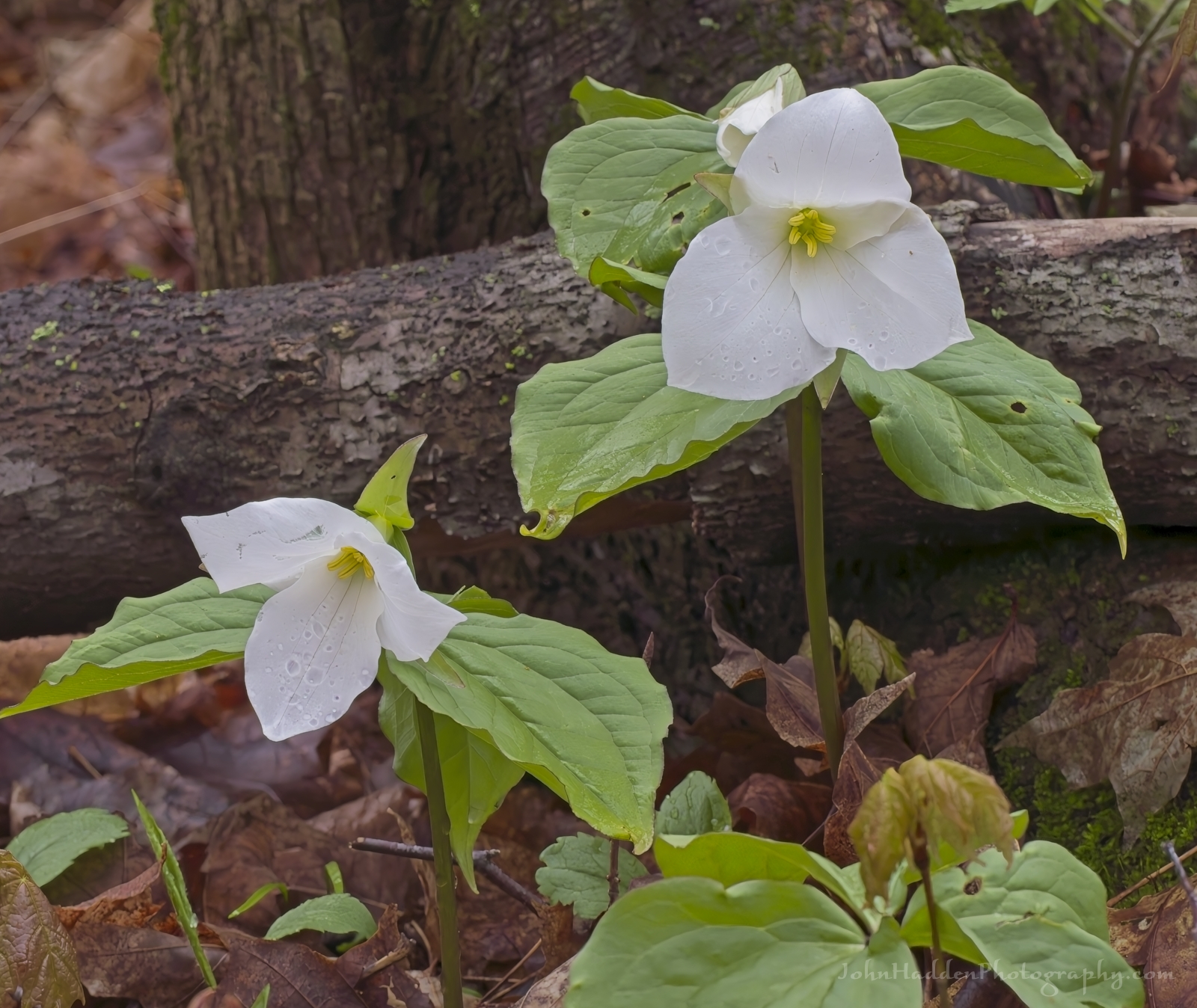 White trillium at Pelots Nature Area
Morning Observation:
This morning in Huntington at 6:20AM it’s currently 47 degrees under mostly cloudy skies. Winds are calm. Relative humidity is 96%, dewpoint 46, barometric pressure 30.15”. We picked up a total of 0.07” of rain yesterday. Yesterday’s high was 69, and yesterday’s low was 48. The overnight low got down to 45.
This morning in North Hero it’s currently 49 degrees under mostly cloudy skies. Winds are calm. Relative humidity is 96%, dewpoint 48, barometric pressure 30.16”. We picked up a total of 0.26” of rain yesterday. Yesterday’s high was 64, and yesterday’s low was 50. The overnight low got down to 48.
Forecast Discussion:
Morning clouds are expected to burn off by midday today bringing partly sunny skies with highs in the upper 60s as high pressure builds into the region. Clouds will be on the increase again tonight as an occluded front approaches from the west. With high pressure over the region, however, most of Vermont should remain dry during the day on Saturday with some possible sprinkles over far northern New York and Vermont. Low pressure tracking through James Bay on Sunday will swing a cold front through the region during the day on Sunday bringing widespread rain Sunday into Sunday night. High pressure and warm temperatures return for the first part of next week before unsettled weather returns from midweek onward.
3-Day Forecast:
We’ll see partly sunny skies today with a high near 67 and southeast winds 3-6 mph. Tonight should be mostly cloudy with a low around 50 and south winds 6-14 mph.
Saturday should be mostly cloudy with a high near 65 and south winds 7-14 mph. Saturday night should be mostly cloudy with a low around 47 and south winds 9-15 mph.
Sunday should be cloudy with showers likely. Highs will be near 56 with south winds around 10 mph. Chance of precipitation is 70% with rainfall amounts between 0.10″-0.25″ possible. Sunday night should be mostly cloudy with a 50% chance of showers. Lows will be around 49 with south winds 7-11 mph. Rainfall amounts of less than 0.10″ are possible.
Almanac:
Last year on this date in Huntington we had a high of 53 and a low of 44. We picked up 0.12″ of rain.
Last year in North Hero we had a high of 52 and a low of 46. We picked up 0.14″ of rain.
Burlington averages for this date are a low of 43 and a high of 64.
The record low was 24 in 1966.
The record high was 89 in 2001 (we had a high of 86 in Huntington).
The Lake Champlain lake level in Burlington is 97.96′.
The water temperature is 44˚.
Last year’s lake level was at 98.67′.
The Mt. Mansfield snow stake depth is 42″.
The average depth for this date is 45″.
Mt. Washington Summit Conditions
Current Temperature: 32˚
Winds are out of the out of the south at 5 mph
24 hr Precipitation: 0.2″ snow, 0.88″ melted precipitation
Visibility: around 70 miles under clear skies.
Sky Notes:
Sunrise: 5:39AM
Sunset: 7:59PM
Length of day: 14:19:45
Today will be 2:36 longer than yesterday.
The Moon is a waning crescent, 24 days old with 30% illumination.
Moonrise: 3:33AM
Moonset: 2:33PM
About Today’s Photo:
The spring wildflowers at Pelots Nature Area in North Hero are putting on a show! I went for a walk yesterday morning and wasn’t disappointed as I came across many different species in bloom. These white trillium were just two of hundreds blooming in the woods near the old railroad bed trail. White trillium bloom in colonies and can carpet the forest floor. According to Mary Holland’s excellent “Naturally Curious” blog, white trillium must grow for 16-17 years before producing a flower, and plants in excess of 70 years of age have been documented. Respect!
Panasonic GX8, Olympus 60mm macro lens, ISO 800, f/11, 1/125″ exposure
Thursday, May 2, 2024

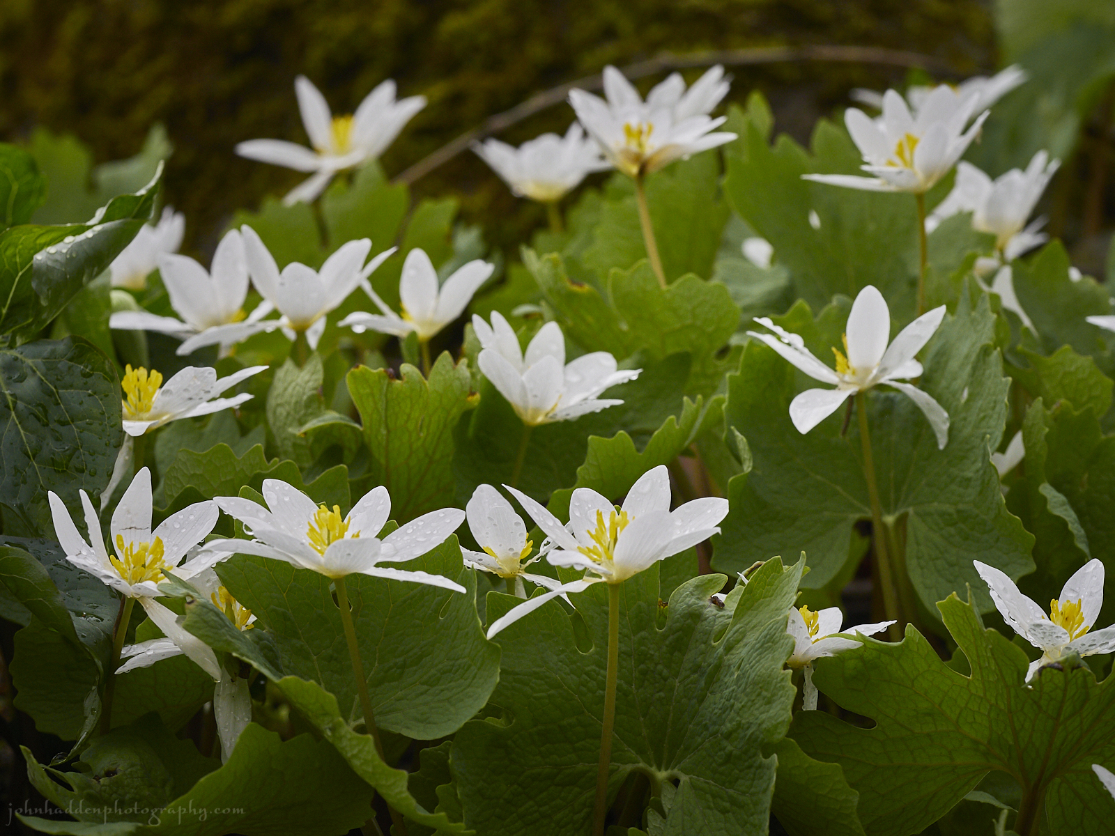 A crop of bloodroot by the Taft Road beaver complex
Morning Observation:
This morning in North Hero at 7:15AM it’s currently 52 degrees under partly sunny skies. Winds are calm. Relative humidity is 98%, dewpoint 52, barometric pressure 29.81”. We picked up 0.01” of rain yesterday and 0.26” so far today during several round of thunderstorms overnight. Yesterday’s high was 59, and yesterday’s low was 43. The overnight low got down to 51.
This morning in Huntington it’s currently 54 degrees under partly cloudy skies. Winds are calm. Relative humidity is 97%, dewpoint 53, barometric pressure 29.84”. We picked up 0.05” of rain yesterday and 0.07” so far today. Yesterday’s high was 66, and yesterday’s low was 44. The overnight low got down to 51.
Forecast Discussion:
Morning sunshine should give way to more clouds later this morning as a weak shortwave trough dips through the region from Canada. Showers and thunderstorms will be most likely over northern Vermont today as highs tick up into the upper 50s and low 60s. High pressure will build in Friday brining some sunshine and warmer temperatures in the upper 60s to low 70s. Low pressure tracking out of the midwest and into the Great Lakes will help transport Gulf of Mexico moisture northeastward over the weekend setting us up for showers later Saturday and into Sunday. High pressure is expected to build back into the region Monday into Tuesday with more active weather expected midweek along with warm temperatures.
3-Day Forecast:
We’ll see partly sunny skies today with a 50% chance of showers and thunderstorms. Highs will be near 65 with south winds 8-11 mph becoming northwesterly in the afternoon. Rainfall amounts of less than 0.10″ are possible with higher amounts possible in thunderstorms. Tonight should be mostly cloudy with a low around 45 and north winds around 6 mph becoming calm after midnight.
Friday should be partly sunny with a high near 66 and south winds 3-5 mph. Friday night should be mostly cloudy with a low around 48 and southeast winds 3-5 mph.
Saturday should be mostly cloudy with a high near 66 and south winds 7-12 mph. Saturday night should be mostly cloudy with a 50% chance of showers. Lows will be around 47 with southeast winds around 9 mph. Rainfall amounts of less than 0.10″ are possible.
Almanac:
Last year on this date in Huntington we had a high of 53 and a low of 35. We picked up 0.23″ of rain.
Last year in North Hero we had a high of 53 and a low of 43. We picked up 0.16″ of rain.
Burlington averages for this date are a low of 43 and a high of 64.
The record low was 27 in 1966.
The record high was 88 in 2018 (we had a high of 86 in Huntington).
The Lake Champlain lake level in Burlington is 97.99′.
The water temperature is 44˚.
Last year’s lake level was at 98.56′.
The Mt. Mansfield snow stake depth is 46″ (4/30).
The average depth for this date is 48″.
Mt. Washington Summit Conditions
Current Temperature: 37˚
Winds are out of the west at 30 gusting to 48 mph
24 hr Precipitation: 0.01″ rain
Visibility: less than 1/16 mile in fog
Sky Notes:
Sunrise: 5:40AM
Sunset: 7:57PM
Length of day: 14:17:09
Today will be 2:37 longer than yesterday.
The Moon is a waning crescent, 23 days old with 41% illumination.
Moonrise: 3:12AM
Moonset: 1:14PM
About Today’s Photo:
There’s a little knoll in the midst of the now sprawling Taft Road beaver complex that sports a bumper crop of bloodroot this time of year. There are dozens of blossoms blooming.
Panasonic GX8, Olympus 60mm macro lens, ISO 800, f/7.1, 1/800″ exposure
Wednesday, May 1, 2024

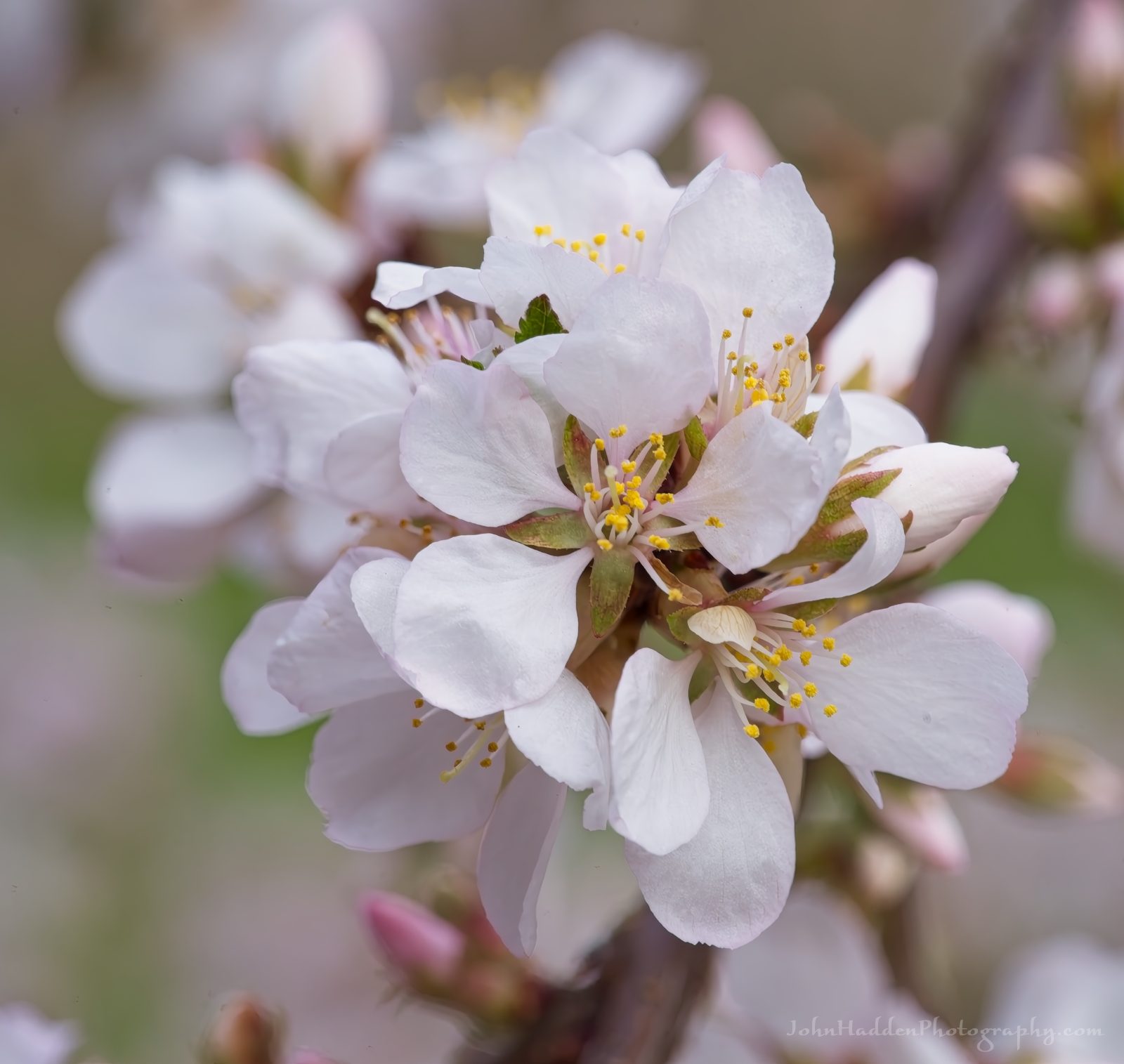 Cherry blossoms bursting
Rabbit-rabbit!
Morning Observation:
This morning in Huntington at 6:15AM it’s currently 44 degrees under cloudy skies. Winds are calm. Relative humidity is 97%, dewpoint 43, barometric pressure 29.91”. We picked up 0.10” of rain yesterday and 0.05” so far today. Yesterday’s high was 60, and yesterday’s low was 43. The overnight low got down to 44.
This morning in North Hero it’s currently 44 degrees under cloudy skies with fog. Winds are calm. Relative humidity is 99%, dewpoint 44, barometric pressure 29.94”. We picked up 0.12” of rain yesterday and 0.01” far today. Yesterday’s high was 59, and yesterday’s low was 443. The overnight low got down to 43.
Forecast Discussion:
Morning fog is the main weather headline for today with valley fog prevalent in the Champlain Valley. We’ll see mostly cloudy skies today with highs in the upper 50s/low 60s north to around 70 south with some terrain driven sprinkles possible during the day today. A weak upper level trough is expected to drop into the region overnight tonight bringing showers overnight and into Thursday. Drier conditions are expected for Friday as a brief ridge of high pressure slides through with some glimpses of sunshine possible Friday afternoon as highs push into the upper 60s and low 70s. Unsettled conditions are expected heading into the weekend as an occluded front moves through sometime later Saturday night into Sunday.
3-Day Forecast:
We’ll see mostly cloudy skies morning fog today with a 20% chance of showers. Highs will be near 60 with light northwest winds. Tonight should be mostly cloudy with showers likely around daybreak. Lows will be around 49 with calm winds becoming southeasterly around 6 mph after midnight. Chance of precipitation is 60% with rainfall amounts of less than 0.10″ possible.
Thursday should be mostly cloudy with a 50% chance of showers, mainly before 5:0PM. Highs will be near 64 with south winds around 9 mph becoming northwesterly in the afternoon. Rainfall amounts of less than 0.10″ are possible. Thursday night should be mostly cloudy with a low around 46 and north winds around 6 mph becoming calm after midnight.
Friday should be partly sunny with a high near 66 with east winds 3-5 mph. Friday night should be mostly cloudy with a low around 48 and southeast winds 3-5 mph.
Almanac:
Last year on this date in Huntington we had a high of 56 and a low of 37. We picked up 0.91″ of rain.
Last year in North Hero we had a high of 55 and a low of 44. We picked up 0.65″ of rain.
Burlington averages for this date are a low of 42 and a high of 64.
The record low was 25 in 1961.
The record high was 86 in 2001 (we had a high of 84 in Huntington).
The Lake Champlain lake level in Burlington is 98.02′.
The water temperature is 44˚.
Last year’s lake level was at 98.40′.
The Mt. Mansfield snow stake depth is 46″.
The average depth for this date is 48″.
Mt. Washington Summit Conditions
Current Temperature: 38˚
Winds are out of the NW at 24-29 mph
24 hr Precipitation: 0.31″ rain
Visibility: about 1/16 mile in fog
Sky Notes:
Sunrise: 5:42AM
Sunset: 7:56PM
Length of day: 14:14:32
today will be 2:39 longer than yesterday.
The Moon is in its last quarter, 22 days old with 52% illumination.
Moonrise: 2:40AM
Moonset: 11:54AM
About Today’s Photo:
We have a Manchu cherry bush on in our patio garden that is producing a profusion of flowers this year. I’m waiting to see what kind of pollinators come to it as I’ve only seen a random bumble bee or two so far this spring.
Sony A7II, Sony 90mm macro lens, ISO 800, f/10, 1/60″ exposure
