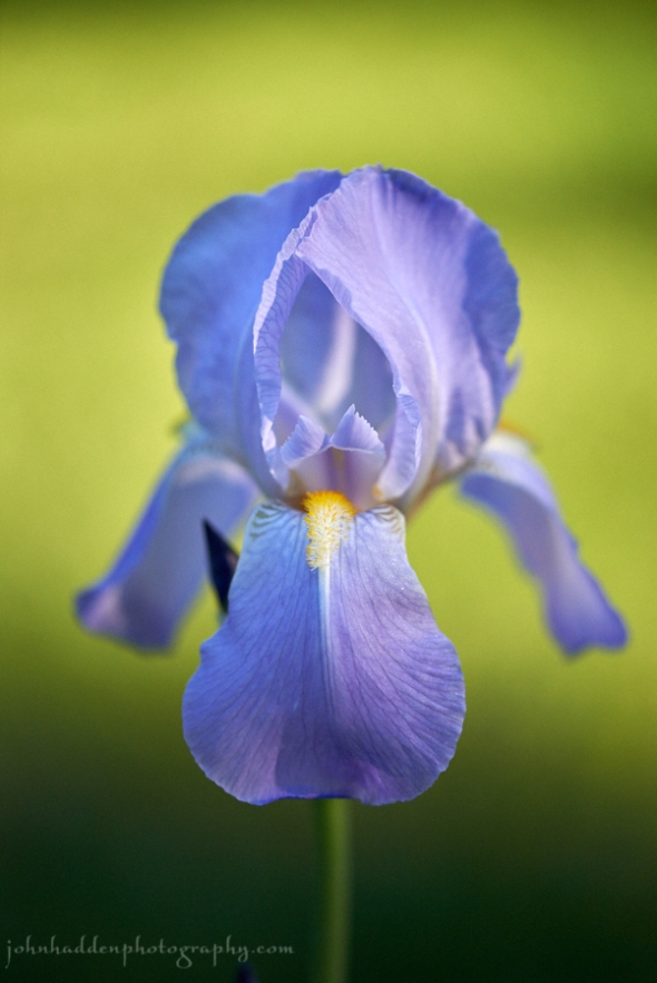
Friday, June 30, 2017

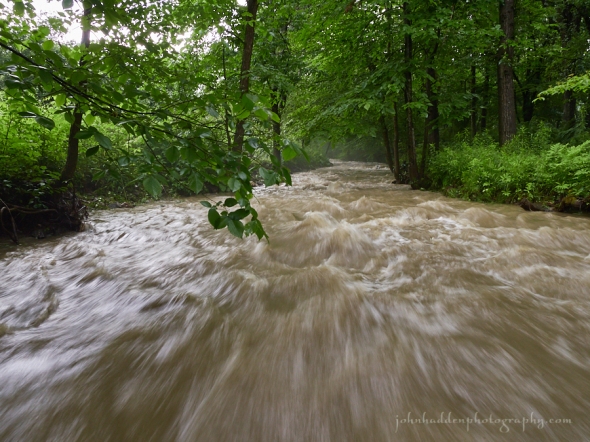
Fargo Brook running high this morning
Morning Observation:
This morning in Huntington at 7:35AM it’s currently 66 degrees and drizzling lightly under overcast skies. Winds are calm. Relative humidity is 98%, dewpoint 65, barometric pressure 29.88” and steady. We picked up a whopping 3.35” of rain in the past 24hrs! This total is only eclipsed by Irene’s rainfall of 5.41”. A distant second would be the July 3rd, 2013 total of 2.23″. Yesterday’s high was 68, and the overnight low was 61.
There is a Flash Flood and Areal Flood Warning for our area until 8:15AM this morning.
Forecast:
Double-barreled low pressure currently over the Great Lakes has dragged a slow moving warm front into the region overnight accompanied by copious amounts of rain. The central Champlain Valley and Huntington in particular seem to have been right in the sights of the bulk of the overnight precipitation. Reports from around the region indicated that we’re the “winner” in terms of rain totals. Lucky us…
Warmer and much more humid conditions are expected across the region through Saturday along with scattered to numerous showers and thunderstorms, mainly in the afternoon and evening hours. A cold front will move through Sunday bringing more rain, but drier air will start to move back in for Monday, with a good amount of sunshine and seasonable temperatures expected for Independence Day.
We’ll see a chance of showers with a slight chance of thunderstorms this morning, then showers and thunderstorms likely this afternoon. Some thunderstorms may produce gusty winds, and heavy rainfall this afternoon. It’ll be warmer with highs in the upper 70s and southwest winds around 10 mph. Chance of rain is 70%. Tonight should be mostly cloudy with showers and thunderstorms likely until midnight, then partly cloudy with a chance of showers and thunderstorms after midnight. Some thunderstorms may produce gusty winds, and heavy rainfall until midnight. Lows will be in the mid 60s with south winds around 10 mph until midnight, becoming light and variable. Chance of rain is 60%.
Saturday should be mostly cloudy with a slight chance of showers and thunderstorms in the morning, then occasional showers and thunderstorms in the afternoon. Some thunderstorms may produce gusty winds, and heavy rainfall in the afternoon. It’ll be humid with highs around 80 and south winds 10 to 15 mph. Chance of rain is 80%. Saturday night should bring occasional showers and thunderstorms. Some thunderstorms may produce gusty winds, and heavy rainfall. Lows wil be in the mid 60s with southwest winds 10 to 15 mph. Chance of rain is 80%.
Sunday’s looking partly sunny with a 30% chance of showers. Highs will be in the upper 70s with west winds around 10 mph. Sunday night should be partly cloudy with lows around 60.
Almanac:
Last year on this date we had a high of 81 and a low of 51. We picked up 0.17″ of rain.
Burlington averages for this date are highs of 80 and lows of 59.
The record high was 93°F in 1946.
The record low was 42°F in 1936.
Sky Notes:
Sunrise: 5:11 AM EDT
Sunset: 8:39 PM EDT
Length of Visible Light: 16h 41m
Length of Day: 15h 28m
Tomorrow will be 0m43s shorter.
The Moon is a waxing crescent, 6.7 days old with 43% illumination.
Moonrise: 12:36 PM EDT
Moonset: 12:28 AM EDT
About Today’s Photo:
Fargo Brook is running high this morning. 3.35″ of rain overnight will do it…
Panasonic GX8, Lumix 14-140mm lens @ 14mm, ISO 400, f/16, 1/15″ exposure.
Thursday, June 29, 2017

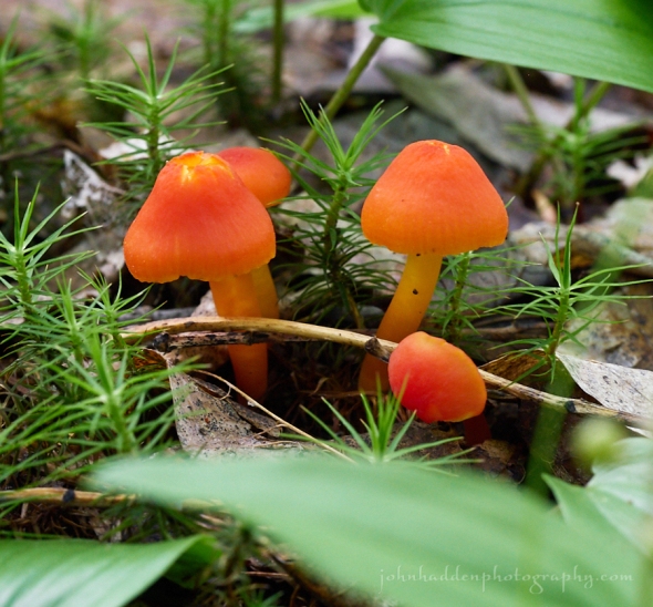
Orange waxcaps popping up in the leaf litter
Morning Observation:
This morning in Huntington at 6:50AM it’s currently 55 degrees under overcast skies. Winds are calm. Relative humidity is 98%, dewpoint 54, barometric pressure 30.096” and steady. We picked up 0.05” of rain in the past 24hrs. Yesterday’s high was 73, and the overnight low was 48.
Forecast:
The unsettled and wet weather train continues to rattle down the tracks. Low pressure moving through the Great Lakes this morning will push a warm front over the region bringing showers to northern New York this morning and into Vermont by midday. The combination of the warm front shifting through the region today,
and a cold front following on Sunday will bring several rounds of showers and thunderstorms over the next few days with increasing humidity through the weekend. Locally heavy rain is possible through Saturday, with increasing potential for isolated flash flooding.
We’ll see cloudy skies today with a chance of showers this morning, then showers likely this afternoon with locally heavy rainfall possible this afternoon. Highs will be in the upper 60s with south winds around 10 mph. Chance of rain is 90%. Tonight showers are likely with a slight chance of thunderstorms until midnight, then showers and thunderstorms likely after midnight with locally heavy rainfall possible until midnight. Lows will be in the lower 60s with southeast winds 10 to 15 mph, becoming southwesterly after midnight. Chance of rain is 90%.
Friday should start out partly sunny in the morning, then become mostly cloudy with a chance of showers and thunderstorms. Locally heavy rainfall possible in the afternoon. It’ll be warmer with highs in the upper 70s and southwest winds around 10 mph. Chance of rain is 50%. Friday night should be mostly cloudy with a 50% chance of showers and thunderstorms. Lows will be in the mid 60s with southwest winds around 10 mph.
Saturday should bring occasional showers and thunderstorms with locally heavy rainfall possible. It’ll be humid with highs in the lower 80s and south winds around 10 mph. Chance of rain is 90%. Saturday night showers and thunderstorms are likely with locally heavy rainfall possible. Lows will be in the mid 60s. Chance of rain is 70%.
Almanac:
Last year on this date we had a high of 77 and a low of 56. We picked up 0.33″ of rain.
Burlington averages for this date are highs of 80 and lows of 59.
The record high was 96°F in 1944.
The record low was 37°F in 1919.
Sky Notes:
Sunrise: 5:10 AM EDT
Sunset: 8:40 PM EDT
Length of Visible Light: 16h 42m
Length of Day: 15h 29m
Tomorrow will be 0m38s shorter.
The Moon is a waxing crescent, 5.7 days old with 32% illumination.
Moonrise: 11:32 AM EDT
No Moon Set
About Today’s Photo:
These diminutive little orange waxcap mushrooms certainly catch your eye when they pop up amongst the moss and leaf litter of the forest floor.
Panasonic GX8, Lumix 60mm macro lens, ISO 1250, f/8, 1/8″ exposure.
Wednesday, June 28, 2017

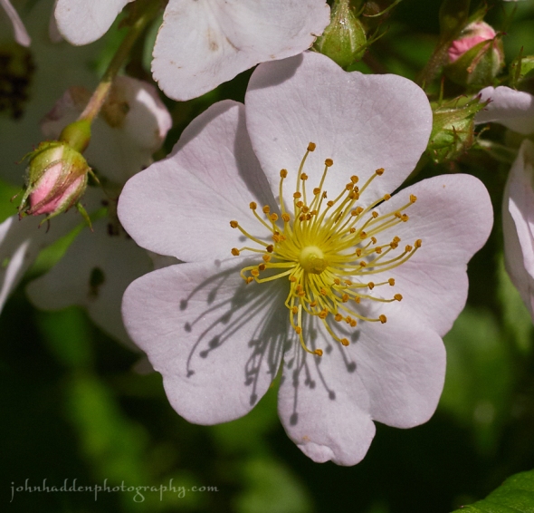
Pale pink rugosa roses blooming along Taft Road
Morning Observation:
This morning in Huntington at 8:10AM it’s currently 55 degrees under overcast skies. Winds are calm. Relative humidity is 98%, dewpoint 55, barometric pressure 30.00” and rising slowly. We picked up 0.44” of rain in the past 24hrs along with some pea-sized hail (lasting about a minute) at around 6:30PM when a squall line moved through. Yesterday’s high was 72, and the overnight low was 47.
Forecast:
We should see a relatively dry day today in comparison to Tuesday with showers being a bit limited this across north central and northeast Vermont with just a slight chance elsewhere. It is still looking like a pattern change takes place
beginning Thursday and continuing right into the weekend as low pressure moving through the Great Lakes Thursday will push a warm front over the region. Expect
warmer and wetter conditions during this period.
We’ll see mostly cloudy skies with isolated showers this morning, then partly sunny skies with a chance of showers this afternoon. Highs will be in the lower 70s with west winds 10 to 15 mph. Chance of rain is 30%. Tonight should be partly cloudy with a 20% slight chance of showers until midnight, then mostly clear after midnight. Lows will be in the mid 50s with southwest winds around 10 mph.
Thursday should be cloudy with a chance of rain in the morning, then rain likely in the afternoon. Highs will be in the upper 60s with south winds 10 to 15 mph. Chance of rain is 90%. Thursday night rain is likely. Lows will be in the lower 60s with south winds 10 to 15 mph. Chance of rain is 90%.
Friday showers are likely with a chance of thunderstorms. It’ll be warmer with highs around 80 and southwest winds around 10 mph. Chance of rain is 60%. Friday night showers are likely with a chance of thunderstorms. Lows will be in the mid 60s. Chance of rain is 70%.
Almanac:
Last year on this date we had a high of 83 and a low od 62.
Burlington averages for this date are highs of 80 and lows of 59.
The record high was 95°F in 1991.
The record low was 43°F in 1927.
Sky Notes:
Sunrise: 5:10 AM EDT
Sunset: 8:40 PM EDT
Length of Visible Light: 16h 42m
Length of Day: 15h 29m
Tomorrow will be 0m35s shorter.
The Moon is a waxing crescent, 4.7 days old with 23% illumination.
Moonrise: 10:26 AM EDT
Moonset: 11:58 PM EDT
About Today’s Photo:
We came across a bloom of pale pink rugosa roses blooming along the side of Taft Road the other day. The blossoms were altogether different than the rugosas we have around our place, with simpler, flatter petal arrangements and a distinctive pale pink color.
Panasonic GX8, Lumix 14-140mm lens @ 140mm, ISO 800, f/14, 1/2000″ exposure.
Tuesday, June 27, 2017


An American toad poses patiently for me on the forest floor
Morning Observation:
This morning in Huntington at 7:40AM it’s currently 59 degrees under mostly clear skies. Wind are calm. Relative humidity is 90%, dewpoint 56, barometric pressure 29.96” and steady. We picked up 0.02” of rain overnight. Yesterday’s high was 71, and the overnight low was 48.
Forecast:
Unsettled weather continues… This morning’s sunning start will give way to clouds and showers which will become widespread during the late morning and afternoon hours courtesy of a shortwave trough approaching from the Great Lakes. Some thunderstorms may pop up as well with gusty winds and small hail. The showers and storms will winds down tonight, and much of the area will be dry on Wednesday with just the possibility of some showers up along the international border. Below normal temperatures will continue through midweek, but a warmer and wetter pattern sets up for the rest of the week and into the weekend as a series of low pressure troughs slide through.
We’ll see partly sunny skies this morning, then mostly cloudy skies with numerous showers with isolated thunderstorms this afternoon. Some thunderstorms may produce gusty winds, and small hail this afternoon. Highs will be in the upper 60s with southwest winds around 10 mph. Chance of rain is 70%. Tonight should be partly cloudy with numerous showers and isolated thunderstorms until midnight, then isolated showers after midnight. Some thunderstorms may produce gusty winds, and small hail until midnight. Lows will be in the lower 50s with southwest winds around 10 mph until midnight, becoming light and variable. Chance of rain is 60%.
Wednesday should be partly sunny with a 20% chance of showers. Highs will be in the upper 60s with west winds around 10 mph. Wednesday night should be partly cloudy with lows in the mid 50s and southwest winds around 10 mph.
Thursday should bring occasional showers. Highs will be in the upper 60s with south winds 10 to 15 mph. Chance of rain is 80%. Thursday night should bring occasional showers. Lows will be in the lower 60s. Chance of rain is 80%.
Almanac:
Last year on this date we had a high of 76 and a low of 62.
Burlington averages for this date are highs of 79 and lows of 59.
The record high was 96°F in 1999 (we had a high of 88).
The record low was 44°F in 1927.
Sky Notes:
Sunrise: 5:09 AM EDT
Sunset: 8:40 PM EDT
Length of Visible Light: 6h 43m
Length of Day: 15h 30m
Tomorrow will be 0m30s shorter.
The Moon is a waxing crescent, 3.6 days old with 14% illumination.
Moonrise: 9:17 AM EDT
Moonset: 11:25 PM EDT
About Today’s Photo:
This fine toad hopped across my path while I was out on a photo walk the other day. Judging by its size, I’d wager it’s a female (which are larger than males). She was quite patient with me as I kneeled in the leaf litter beside her to snap her portrait. Eastern American toads (Bufo americanus) are ubiquitous in our region and feed on crickets, mealworms, earthworms, ants, spiders, slugs, centipedes, moths, and other small invertebrates. Their habitats are widespread including forests, fields, and grasslands, their only requirement being a semi-permanent body of water where they breed and can find drinking water.
Panasonic GX8, Olympus 60mm macro lens, ISO 2500, f/3.2, 1/25″ exposure.
Monday, June 26, 2017


A bluejay fledgling perches motionless as I snap his photo
Morning Observation:
This morning in Huntington at 7:20AM it’s currently 54 degrees under clear skies. Winds are calm. Relative humidity is 98%, dewpoint 54, is 29.94” and steady. We picked up 0.39” of rain in the past 24hrs. Yesterday’s high was 75, and the overnight low was 47.
Forecast:
We’ve got a week of active weather ahead as a series of through wend their way across the region over the next several days bringing occasional showers and thunderstorms throughout the week. We’ll have a dry start to the day today, but scattered showers and isolated thunderstorms are expected to fire up this afternoon and evening. An even greater likelihood of showers and thunderstorms is expected on Tuesday. Temperatures will be several degrees below normal both today and Tuesday. The threat of showers will continue into Wednesday, but then a change will take place to a warming trend starting Thursday and continuing
through the weekend. Showery weather will continue however.
We’ll see partly sunny skies today with isolated showers this afternoon. Highs will be in the upper 60s with west winds around 10 mph this morning, becoming light and variable. Chance of rain is 20%. Tonight should be mostly cloudy until midnight, then become partly cloudy with isolated thunderstorms and scattered showers until midnight. Lows will be in the mid 50s with light and variable winds. Chance of rain is 40%.
Tuesday should be partly sunny with a chance of showers in the morning, then mostly cloudy with showers likely and a slight chance of thunderstorms in the afternoon. Highs will be in the upper 60s with southwest winds around 10 mph. Chance of rain is 70%. Tuesday night should be partly cloudy with a 50% chance of showers. Lows will be around 50 with southwest winds around 10 mph.
Wednesday’s looking partly sunny with a 40% chance of showers. Highs will be in the lower 70s with west winds around 10 mph. Wednesday night should be partly cloudy with a 30% chance of showers. Lows will be in the mid 50s.
Almanac:
Last year on this date we had a high of 87 and a low of 54.
Burlington averages for this date are highs of 79 and lows of 58.
The record high was 96°F in 2007 (we had a high of 92).
The record low was 41°F in 1979.
Sky Notes:
Sunrise: 5:09 AM EDT
Sunset: 8:40 PM EDT
Length of Visible Light: 16h 44m
Length of Day: 15h 30m
Tomorrow will be 0m25s shorter.
The Moon is a waxing crescent, 2.5 days old with 7% illumination.
Moonrise: 8:07 AM EDT
Moonset: 10:47 PM EDT
About Today’s Photo:
I was on a photo walk through the woods when I came across this bluejay fledgling. He was perched on a branch on the forest floor and stayed utterly motionless as I crept in slowly and quietly to take a shot. I had my macro lens on my camera and didn’t want to stick around long enough to change to a longer lens. The bird was obliging as I got about 5″ away. One of its parents was nearby keeping an eye on the situation.
I read up a bit about finding fledglings on the ground. With bluejays it’s apparently common to find still-flightless fledglings on the ground. Supposedly this little guy will soon be able to fly and fend for itself. I wish it good luck!
Panasonic GX8, Olympus 60mm macro lens, ISO 2500, f/3.2, 1/100″ exposure.
Sunday, June 25, 2017

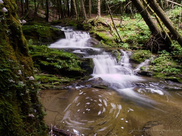
An unnamed waterfall in an unnamed brook off of Taft Road
Morning Observation:
This morning in Huntington at 7:55AM it’s currently 62 degrees under mostly clear skies. Wind are calm. Relative humidity is 95%, dewpoint 60, barometric pressure 29.91” and rising slowly. We picked up 0.03” of rain in the past 24hrs. Yesterday’s high was 80, and the overnight low was 50.
Forecast:
This morning’s sunshine will give way to scattered showers and thunderstorms later this afternoon as low pressure currently over the Great Lakes heads in our direction. Gusty winds and small hail will be possible with any of the thunderstorms. The showers and storms will taper off tonight, but the potential
for additional showers or storms will develop once again Monday afternoon. High temperatures will be right around seasonal averages today and a few degrees below normal on Monday.
We’ll see partly sunny skies this morning with scattered showers and thunderstorms this afternoon. Some thunderstorms may produce gusty winds, and small hail this afternoon. Highs will be in the mid 70s with light and variable winds, becoming southwesterly around 10 mph this afternoon. Chance of rain is 50%. Tonight should be partly cloudy with scattered showers and thunderstorms until midnight, then isolated showers after midnight. Some thunderstorms may produce gusty winds, and small hail until midnight. Lows will be in the lower 50s with west winds around 10 mph. Chance of rain is 50%.
Monday should be partly sunny with a slight chance of showers and thunderstorms in the afternoon. Highs will be in the upper 60s with west winds around 10 mph. Chance of rain is 20%. Monday night should be mostly cloudy with a 50% chance of showers. Lows will be in the lower 50s with southwest winds around 10 mph.
Tuesday showers are likely. Highs will be in the upper 60s with southwest winds around 10 mph. Chance of rain is 60%. Tuesday night should be partly cloudy with a 50% chance of showers. Lows will be in the lower 50s.
Almanac:
Last year on this date we had a high of 84 and a low of 48.
Burlington averages for this date are highs of 79 and lows of 58.
The record high was 94°F in 1995.
The record low was 39°F in 1979.
Sky Notes:
Sunrise: 5:09 AM EDT
Sunset: 8:40 PM EDT
Length of Visible Light: 16h 44m
Length of Day: 15h 31m
Tomorrow will be 0m22s shorter.
The Moon is a waxing crescent, 1.4 days old with 2% illumination.
Moonrise: 6:58 AM EDT
Moonset: 10:02 PM EDT
About Today’s Photo:
There’s a new trail off of Taft Road that passes along an unnamed brook. This lovely little waterfall drops along the stream under the shelter of a hemlock forest. While shooting the falls, I noticed one of the hemlock trees sported a crop of fine little mushrooms. I was happy to get them and the falls in the shot! A slow shutter speed adds to the magic of the place.
Panasonic GX8, Lumix 14-140mm lens @ 14mm, ISO 100, f/22, 2″ exposure.
Saturday, June 24, 2017

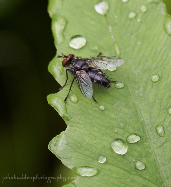
Up close and personal with a fly on a fern
Morning Observation:
This morning in Huntington at 6:20AM it’s currently 66 degrees under overcast skies. A few drops of rain are dripping. Relative humidity is 98%, dewpoint 66, barometric pressure 29.48” and rising slowly. We picked up 0.93” of rain in the past 24hrs. Yesterday’s high was 85, and the overnight low was 66.
Forecast:
Showers will be moving east out of the region today with suunshine is expected to develop later in the day. Highs will be a few degrees above normal today then return to seasonal norms on Sunday as clouds increase along with the chance for showers. Unsettled weather is expected for much of next week with chances for showers just about everyday. Temperatures will be slightly below normal through midweek trending to above normal for the end of the week.
We’ll see partly cloudy skies with a slight chance of thunderstorms and showers, mainly this morning. Highs will be in the upper 70s with west winds around 10 mph. Chance of rain is 40%. Tonight should be mostly clear until midnight, then become partly cloudy after midnight. Lows will be in the mid 50s with west winds around 10 mph.
Sunday should be partly sunny with a chance of showers in the morning, then showers likely in the afternoon. Highs will be in the mid 70s with southwest winds around 10 mph. Chance of rain is 70%. Sunday night should be mostly cloudy with a 50% chance of showers. Lows will be in the lower 50s with southwest winds around 10 mph.
Monday’s looking partly sunny with a 50% chance of showers. Highs will be around 70 with west winds around 10 mph. Monday night should be partly cloudy with a 50% chance of showers. Lows will be in the lower 50s.
Almanac:
Last year on this date we had a high of 78 and a low of 44.
Burlington averages for this date are highs of 79 and lows of 58.
The record high was 96°F in 2003 (we had a high of 92).
The record low was 40°F in 1988.
Sky Notes:
Sunrise: 5:08 AM EDT
Sunset: 8:40 PM EDT
Length of Visible Light: 16h 44m
Length of Day: 15h 31m
Tomorrow will be 0m18s shorter.
The Moon is a waxing crescent, just barely into its first day with 0.5″ illumination.
Moonrise: 5:52 AM EDT
Moonset: 9:08 PM EDT
About Today’s Photo:
A close-up shot reveals an impressive bristle of on the abdomen and legs of this fly as it takes a time out on a fern leaf.
Nikon D600, Sigma 105mm macro lens, ISO 1250, f/18, 1/200″ exposure.
Friday, June 23, 2017


A wasp stakes out a peopie bud
Morning Observation:
This morning in Huntington at 7:35AM it’s currently 64 degrees and raining steadily under overcast skies. Winds are out of the south at 4-6 mph. Relative humidity is 98%, dewpoint 64, barometric pressure 29.74” and falling slowly. We picked up 0.78” of rain overnight along with a rumble of thunder about an hour ago. Yesterday’s high was 77, and the overnight low was 61.
Forecast:
Low pressure currently centered over James Bay is rotating a warm front through the region this morning brining showers and thunderstorms. Locally heavy rainfall is possible with stronger showers and storms. A cold front will move through the region tonight reducing the humidity and bringing a brief return to mainly dry weather on Saturday. More showers return Sunday into early next week. Temperatures will be near to a bit below their seasonal averages, with highs
in the 70s to low 80s and lows in the 50s and low 60s.
We’ll see showers with a slight chance of thunderstorms this morning, then showers and thunderstorms likely this afternoon. Some thunderstorms may produce gusty winds, small hail, and heavy rainfall this afternoon. Highs will be in the lower 80s with southwest winds 10 to 15 mph. Chance of rain is 70%. Tonight should be cloudy with showers and thunderstorms likely until midnight, then a chance of showers with a slight chance of thunderstorms after midnight. Some thunderstorms may produce gusty winds, small hail, and heavy rainfall until midnight. Lows will be in the mid 60s with southwest winds around 10 mph. Chance of rain is 60%.
Saturday should be partly sunny with a30% chance of showers and a slight chance of thunderstorms in the morning, then a slight chance of showers in the afternoon. Highs will be in the upper 70s with northwest winds around 10 mph. Saturday night should be partly cloudy with lows in the upper 50s and west winds around 10 mph.
Sunday’s looking partly sunny with a 40% chance of showers. Highs will be in the mid 70s with southwest winds around 10 mph. Sunday night should be partly cloudy with a 40% chance of showers. Lows will be in the mid 50s.
Almanac:
Last year on this date we had a high of 76 and a low of 47. We picked up 0.53″ of rain.
Burlington averages for this date are highs of 79 and lows of 58.
The record high was 93°F in 1975.
The record low was 41°F in 1940.
Sky Notes:
Sunrise: 5:08 AM EDT
Sunset: 8:40 PM EDT
Length of Visible Light: 16h 45m
Length of Day: 15h 31m
Tomorrow will be 0m13s shorter.
The Moon new, 28 days old with 0% illumination.
Moonrise: 4:54 AM EDT
Moonset: 8:06 PM EDT
About Today’s Photo:
I was poking about in our ornamental garden the other day and noticed quite a lot of insect activity around the peonie buds. There were ants, wasps, flies, and other critters all hanging around the unopened buds. My guess is that there was some kind of sweet stuff present that was attracting them.
Nikon D600, Sigma 105mm macro lens, ISO 1250, f/13, 1/160″ exposure.
Thursday, June 22, 2017

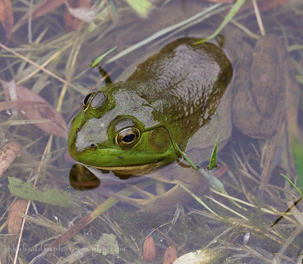
A green frog hangs out in the shallows of our pond
Morning Observation:
This morning in Huntington at 6:15AM it’s currently 50 degrees under clear skies. Winds are calm. Relative humidity is 98%, dewpoint 50, barometric pressure 29.95” and rising slowly. Yesterday’s high was 73, and the overnight low was 49.
Forecast:
We’ll enjoy seasonably pleasant weather through this afternoon courtesy of high pressure currently building into the region. Showers and thunderstorms return, howerver, overnight into Friday as low pressure approaches from the west dragging subtropical moisture into the region. A warm front will lift through the region overnight into the morning hours bringing locally heavy rainfall, then a cold front will bring more heavy rains Friday afternoon. We’ll see a brief return to dry weather on Saturday before more showers return for the early portions of next week.
We’ll see mostly sunny skies today with highs in the upper 70s and southwest winds around 10 mph. Tonight should bring isolated thunderstorms and occasional showers. Lows will be in the lower 60s with light and variable winds, becoming southerly around 10 mph after midnight. Chance of rain is 80%.
Friday showers and thunderstorms are likely. Some thunderstorms may produce heavy rainfall. Highs will be around 80 with south winds 15 to 20 mph. Chance of rain is 80%. Friday night showers and thunderstorms are likely. Some thunderstorms may produce heavy rainfall. It’ll be humid with lows in the mid 60s and southwest winds 10 to 15 mph gusting up to 25 mph. Chance of rain is 70%.
Saturday’s looking partly sunny with scattered showers. Highs will be in the mid 70s with west winds 10 to 15 mph. Chance of rain is 50%. Saturday night should be partly cloudy with lows in the mid 50s.
Almanac:
Last year on this date we had a high of 69 and a low of 45. We picked up 0.03″ of rain.
Burlington averages for this date are highs of 78 and lows of 57.
The record high was 92°F in 1921.
The record low was 39°F in 1940.
Sky Notes:
Sunrise: 5:08 AM EDT
Sunset: 8:39 PM EDT
Length of Visible Light: 16h 45m
Length of Day: 15h 31m
Tomorrow will be 0m9s shorter.
The Moon is a waning crescent, 27 days old with 5% illumination.
Moonrise: 4:03 AM EDT
Moonset: 6:57 PM EDT
About Today’s Photo:
The amphibian population of our pond goes through interesting seasonal cycles. We start with the wood frogs at ice-out, then the peepers, then the toads. Now we’re into green frog season with their distinctive “banjo string” calls. They’re accompanied this time of year by grey tree frogs along with the occasional peeper soloist and guest appearance by a toad or two.
Nikon D600, Sigma 105mm macro lens, ISO 800, f/8, 1/1000″ exposure.
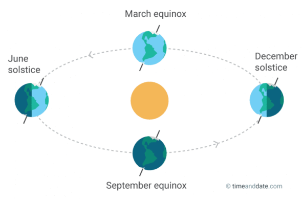
Wednesday, June 21, 2017, the Summer Solstice


A fly pauses on a rain soaked white iris by the pond
Happy Solstice!
Morning Observation:
This morning in Huntington at 7:30AM it’s currently 63 degrees under partly cloudy skies. Winds are out of the west at 3-5 mph. Relative humidity is 88%, dewpoint 59, barometric pressure 29.82” and steady. We picked up 0.50” of rain in the past 24hrs. Yesterday’s high was 75, and the overnight low was 54.
Forecast:
The low pressure system that has been delivering our unsettled weather is finally departing the region, however it still may deliver a few scattered showers this afgternoon. High pressure will build in briefly tonight into Thursday bringing dry conditions before another low pressure system and associated warm front bring more rain on Friday. Temperatures will be near their seasonal averages, with highs in the 70s to low 80s and lows in the 50s and low 60s.
We’ll see partly sunny skies today with a chance of showers with a slight chance of thunderstorms this morning, then scattered showers this afternoon. Highs will be in the lower 70s with west winds 10 to 15 mph. Chance of rain is 50%. Tonight should be partly cloudy with isolated showers until midnight, then mostly clear after midnight. Lows will be in the lower 50s with west winds 10 to 15 mph. Chance of rain is 20%.
Thursday should be sunny in the morning then become partly cloudy. Highs will be in the mid 70s with west winds around 10 mph. Thursday night should be mostly cloudy with a 50% chance of showers. Lows will be around 60 with south winds around 10 mph.
Friday showers and thunderstorms are likely. Some thunderstorms may produce heavy rainfall. Highs will be around 80 with south winds 10 to 15 mph gusting up to 25 mph. Chance of rain is 70%. Friday night showers are likely. Lows will be in the lower 60s. Chance of rain is 70%.
Almanac:
Last year on this date we had a high of 79 and a low of 50. We picked up 0.04″ of rain.
Burlington averages for this date are highs of 78 and lows of 57.
The record high was 97°F in 2012 (we had a high of 92).
The record low was 42°F in 1926.
Sky Notes:
Sunrise: 5:07 AM EDT
Sunset: 8:39 PM EDT
Length of Visible Light: 16h 45m
Length of Day: 15h 31m
Tomorrow will be 0m5s shorter.
The Moon is a waning crescent, 26 days old with 11% illumination.
Moonrise: 3:19 AM EDT
Moonset: 5:43 PM EDT
The Summer Solstice occurred early this morning at 12:24AM. The Solstice occurs when the Earth’s rotational axis is most inclined toward the Sun. On the summer solstice, Earth’s maximum axial tilt toward the Sun is 23.44°. In the northern hemisphere, this marks the beginning of astronomical summer and is the longest day of the year. Here’s a handy graphic:
About Today’s Photo:
We have a batch of white irises by the pond-—the only white ones we have. This little fly was taking a break yesterday morning on a rain soaked (and a bit past its prime) blossom.
Nikon D600, Sigma 105mm macro, ISO 1250, f/18, 1/400″ exposure.
Tuesday, June 20, 2017


Canadian anenome blooming at the edge of our front field.
Morning Observation:
This morning in Huntington at 7:30AM it’s currently 65 degrees and raining lightly under overcast skies. Winds are calm. Relative humidity is 98%, dewpoint 64, barometric pressure 29.73” and steady. We picked up 0.81” of rain in the past 24hrs. Yesterday’s high was 82, and the overnight low was 61.
Forecast:
An large area of low pressure over eastern Canada will continue rotate a series of shortwave troughs across our region over the next two days delivering unsettled weather. A brief spot of high pressure will bring drier conditions Thursday before the next low and associated cold front approaches from the Great Lakes on Friday bringing more showers. Temperatures will be near normal for this time of year with highs in the upper 70s to low 80s and lows in the 50s and low 60s.
We’ll see mostly cloudy skies this morning, becoming partly sunny this afernoon. There’s a 505 chance of showers with a slight chance of thunderstorms through midday. Highs will be in the mid 70s with southwest winds 10 to 15 mph. Tonight should be partly cloudy with a 30% chance of showers and a slight chance of thunderstorms until midnight, then cloudy with a slight chance of showers after midnight. Lows will be in the mid 50s with southwest winds 10 to 15 mph. Chance of rain is 30%.
Wednesday (the Summer Solstice!) should start out partly sunny in the morning, then become mostly cloudy with a slight chance of showers in the morning, then a chance of showers in the afternoon. Highs will be in the lower 70s with west winds 10 to 15 mph. Chance of rain is 40%. Wednesday night should be partly cloudy with a 30% chance of showers. Lows will be in the lower 50s with west winds around 10 mph.
Thursday’s looking mostly sunny with highs in the mid 70s and light and variable winds. Thursday night should be mostly cloudy with a 50% chance of showers. Lows will be in the lower 60s.
Almanac:
Last year on this date we had a high of 86 and a low of 56.
Burlington averages for this date are a high of 78 and a low of 57.
The record high was 95°F in 2012 (we had a high of 92).
The record low was 35°F in 1918.
Sky Notes:
Sunrise: 5:07 AM EDT
Sunset: 8:39 PM EDT
Length of Visible Light: 16h 45m
Length of Day: 15h 31m
Tomorrow will be 0m1s longer.
The Moon is a waning crescent, 25 days old with 20% illumination.
Moonrise: 2:41 AM EDT
Moonset: 4:29 PM EDT
About Today’s Photo:
We have several places around the fringes of our “taken care of” lawn and gardens where the white blossoms of Canadian anenome are blooming now. These native perennials like to “volunteer” and will quickly spread via their rhizomes to colonize areas if not kept in check. I’m always willing to let a few pop up in our tended flower beds at least until the blooms fade.
Nikon D600, Sigma 105mm macro lens, ISO 800, f/8, 1/640″ exposure.
Monday, June 19, 2017

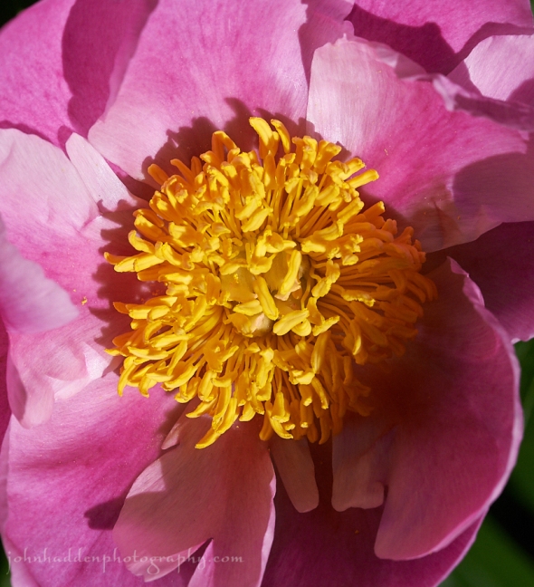
In close with a peonie blossom
Morning Observation:
This morning in Huntington at 7:20AM it’s currently 70 degrees under overcast skies. Winds are calm. Relative humidity is 97%, dewpoint 69, barometric pressure 29.71” and rising slowly. We picked up 0.47” of rain overnight when the line of thunderstorms rolled through starting at around 11:30PM. Yesterday’s high was 88, and the overnight low was 67.
Forecast:
Showers and thunderstorms with very heavy rainfall will form today, mainly in Vermont and the Champlain Valley of northern New York. A Flash Flood Watch is in effect this afternoon and evening. Small hail and gusty winds are also possible in the stronger storms. The threat for heavy rainfall and wind will lessen after tonight, however the weather will remain unsettled this week as a trough of low pressure centered over southern Ontario this morning slowly moves through the
area.
Showers are likely with a slight chance of thunderstorms this morning, then occasional showers and thunderstorms this afternoon. Some thunderstorms may produce gusty winds, small hail, and heavy rainfall this afternoon. Highs will be in the upper 70s with southwest winds 10 to 15 mph. Chance of rain is 90%. Tonight will be cloudy with occasional showers and thunderstorms until midnight, then a chance of showers and a slight chance of thunderstorms after midnight. Some thunderstorms may produce gusty winds, small hail, and heavy rainfall until midnight. Lows will be around 60 with south winds around 10 mph. Chance of rain is 80%.
Tuesday should be mostly cloudy in the morning then become partly sunny with a 50% chance of terrain driven showers with a slight chance of thunderstorms. Highs will be in the mid 70s with southwest winds 10 to 15 mph. Tuesday night should be partly cloudy with a 40% chance of showers. Lows will be in the upper 50s with southwest winds around 10 mph.
Wednesday’s looking mostly cloudy with a 50% chance of terrain driven showers. Highs will be in the lower 70s with southwest winds 10 to 15 mph gusting up to 25 mph. Wednesday night should be partly cloudy with lows in the mid 50s.
Almanac:
Last year on this date we had a high of 87 and a low of 52.
Burlington averages for this date are highs of 77 and lows of 57.
The record high was 100°F in 1995.
The record low was 37°F in 1946.
Sky Notes:
Sunrise: 5:07 AM EDT
Sunset: 8:39 PM EDT
Length of Visible Light: 16h 45m
Length of Day: 15h 31m
Tomorrow will be 0m4s longer.
The moon is a waning crescent, 24 days old with 30% illumination.
Moonrise: 2:08 AM EDT
Moonset: 3:16 PM EDT
About Today’s Photo:
Looking close at a peonie blossom in our ornamental garden reveals a jumble of bright yellow anthers. The fragrance of the blossom was intoxicating!
Nikon D600, Sigma 105mm macro lens, ISO 800, f/13, 1/1000″ exposure.
Sunday, June 18, 2017

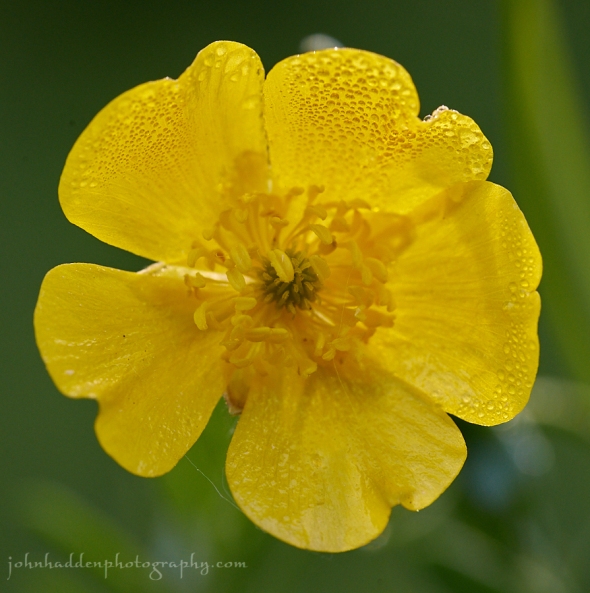
A dew bespecked buttercup in our front field
Morning Observation:
This morning in Huntington at 7:00AM it’s currently a balmy 73 degrees under partly cloudy skies. Winds are out of the south at 0-4 mph. Relative humidity is 83%, dewpoint 67, barometric pressure 29.77”. Yesterday’s high was 84, and the overnight low was 69.
Forecast:
We’ve got another very warm and humid day on tap today before strong to severe
thunderstorms arrive this afternoon and evening out ahead of a cold front approaching from the west. The stronger storms will be capable of damaging winds, large hail, heavy downpours, and frequent lightning, especially across northern New York into the Champlain Valley. Additional showers and thunderstorms are expected on Monday, along with the potential for localized flash flooding associated with very high rainfall rates. Cooler and drier weather arrives by midweek.
We’ll see partly sunny skies today with a 30% chance of showers and thunderstorms this afternoon. Highs will be in the upper 80s with south winds 15 to 20 mph with gusts up to 30 mph. Chance of rain 30 percent. Tonight showers and thunderstorms likely, mainly until midnight. Some thunderstorms may produce damaging winds, large hail, and heavy rainfall. It’ll be humid with lows in the upper 60s and south winds 15 to 20 mph. Chance of rain is 70%.
Monday will bring occasional showers and a slight chance of thunderstorms. Some thunderstorms may produce gusty winds, small hail, and heavy rainfall in the afternoon. It’ll be humid with highs in the lower 80s and southwest winds 10 to 15 mph. Chance of rain is 90%. Monday night showers are likely. Lows will be in the lower 60s with south winds around 10 mph. Chance of rain is 70%.
Tuesday showers are likely. Highs will be in the mid 70s with southwest winds around 10 mph. Chance of rain is 60%. Tuesday night should be partly cloudy with a 50% chance of showers. Lows will be in the upper 50s.
Almanac:
Last year on this date we had a high of 84 and a low of 46.
Burlington averages for this date are highs of 77 and lows of 56.
The record high was 97°F in 1994.
The record low was 40°F in 1964.
Sky Notes:
Sunrise: 5:07 AM EDT
Sunset: 8:39 PM EDT
Length of Visible Light: 16h 45m
Length of Day: 15h 31m
Tomorrow will be 0m9s longer.
The Moon is a waning crescent, 23 days old with 41% illumination.
Moonrise: 1:37 AM EDT
Moonset: 2:05 PM EDT
About Today’s Photo:
It’s a good year for the diminutive buttercup! We’ve got a good crop growing in our front field, and there’s a spot along the Richmond Road just before the Farr Farm that’s carpeted with ’em.
Nikon D600, Sigma 105mm macro lens, ISO 800, f/13, 1/125″ exposure.
Saturday, June 17, 2017

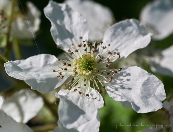
Blackberry blossoms along Fargo Brook
Morning Observation:
This morning in Huntington at 7:45AM it’s currently 67 degrees under partly cloudy skies. Winds are out of the south at 1-3 mph. Relative humidity is 81%, dewpoint 61, barometric pressure 29.92” and steady. We picked up 0.32” of rain in the past 24hrs (0.64” for the storm). Yesterday’s high was 67, and the overnight low was 61.
Forecast:
An increasing south to southwest air flow will deliver building heat and humidity this weekend with highs in the 80s today and upper 80s to lower 90s on Sunday. Isolated thunderstorms are possible late this afternoon or evening especially east. An approaching cold front will bring the threat for strong to locally severe thunderstorms Sunday evening into Monday, along with locally heavy rainfall with a very moist air mass in place ahead of the front. Cooler weather will follow behind the front into midweek.
We’ll see partly sunny skies today. It’ll be much warmer with highs in the mid 80s with south winds around 10 mph. Tonight should be partly cloudy with lows in the mid 60s and south winds around 10 mph.
Sunday should be partly sunny with a slight chance of showers or thunderstorms in the afternoon. It’ll be humid with highs in the upper 80s and south winds 10 to 15 mph gusting up to 25 mph. Chance of rain is 20%. Sunday night should be partly cloudy with a 50% chance of showers and thunderstorms. It’ll be humid with lows in the upper 60s and south winds 15 to 20 mph.
Monday will bring showers and thunderstorms. Some thunderstorms may produce gusty winds, small hail, and heavy rainfall. It’ll be continued humid with highs in the mid 80s and southwest winds 10 to 15 mph. Chance of rain is 90%. Monday night showers are likely. Lows will be in the lower 60s. Chance of rain is 90%.
Almanac:
Last year on this date we had a high of 80 and a low of 43.
Burlington averages for this date are highs of 77 and lows of 56.
The record high was 96°F in 1994.
The record low was 42°F in 1925.
Sky Notes:
Sunrise: 5:07 AM EDT
Sunset: 8:38 PM EDT
Length of Visible Light: 16h 44m
Length of Day: 15h 31m
Tomorrow will be 0m13s longer.
The Moon is in its last quarter, 22 days old with 52% illumination.
Moonrise: 1:06 AM EDT
Moonset: 12:57 PM EDT
About Today’s Photo:
The blackberry canes have produced a bumper crop of blossoms this season–good news for yummy berries later this summer! We have quite a few growing along Fargo Brook.
Nikon D600, Sigma 105mm macro lens, ISO 800, f/13, 1/100″ exposure.
Thursday, June 15, 2017

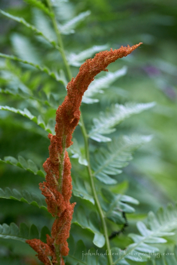
Cinnamon fern across Fargo Brook
Morning Observation:
This morning in Huntington at 7:40AM it’s currently 51 degrees under mostly clear skies. Winds are calm. Relative humidity is 97%, dewpoint 50, barometric pressure 30.08” and steady. Yesterday’s high was 69, and the overnight low was 39.
Forecast:
We’ve got a lovely day on tap today courtesy of high pressure cresting over the region today and delivering dry conditions and seasonal temperatures. A warm front will slide northward tonight bringing showers overnight into Friday followed by warmer, more humid, and unsettled weather through Monday. There will be several chances of showers and thunderstorms until a cold front moves through on Monday.
We’ll see mostly sunny skies today with highs in the upper 70s and light and variable winds. Tonight should be partly cloudy with a chance of showers until midnight, then cloudy with showers likely after midnight. Lows will be in the mid 50s with south winds 10 to 15 mph. Chance of rain is 80%.
Friday showers are likely. Highs will be in the mid 60s with south winds 15 to 20 mph gusting up to 30 mph. Chance of rain is 80%. Friday night should be mostly cloudy with a 50% chance of showers. Lows will be in the upper 50s with southeast winds 10 to 15 mph gusting up to 25 mph.
Saturday should be partly sunny with a 30% chance of showers. It’ll be much warmer with highs in the lower 80s and south winds 10 to 15 mph. Saturday night should be partly cloudy with a 40% chance of showers. Lows will be in the mid 60s.
Almanac:
Last year on this date we had a high of 73 and a low of 48.
Burlington averages for this date are highs of 76 and lows of 55.
The record high was 97°F in 1988.
The record low was 41°F in 1923.
Sky Notes:
Sunrise: 5:07 AM EDT
Sunset: 8:37 PM EDT
Length of Visible Light: 16h 44m
Length of Day: 15h 30m
Tomorrow will be 0m22s longer.
The Moon is waning gibbous, 20 days old with 72% illumination.
Moonrise: 12:04 AM EDT
Moonset: 10:48 AM EDT
About Today’s Photo:
Cinnamon ferns (Osmundastrum) are in their prime across Fargo Brook now. This particular species of fern produce separate sterile and fertile, spore-bearing fronds. The spore-bearing fronds are a deep cinnamon color and hence the common name.
Nikon D600, Sigma 105mm macro lens, ISO 1250, f/8, 1/13″ exposure.
Wednesday, June 14, 2017

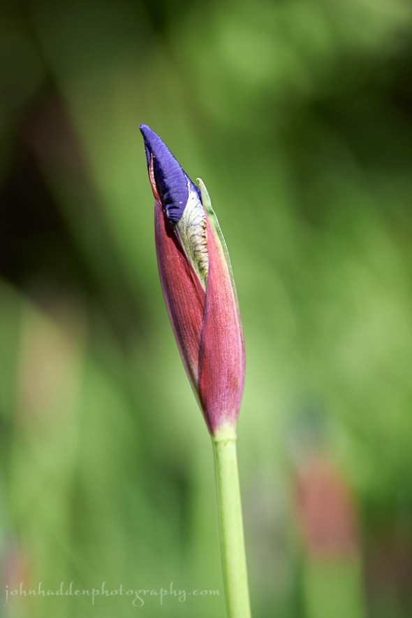
A Siberian iris bud about to bloom
Morning Observation:
This morning in Huntington at 7:30AM it’s currently 53 degrees under clear skies. Winds are calm. Relative humidity is is 98%, dewpoint 52, barometric pressure 30.06” and rising rapidly. We picked up just a trace of rain in the past 24hrs. Yesterday’s high was 83, and the overnight low was 43.
Forecast:
High pressure is currently building into the region and will dominate our weather through Thursday with dry conditions and seasonably cool temperatures. Warmer and more unsettled weather returns for the end of the week as a warm front moves in Thursday night kicking off the daily chance of showers and
thunderstorms through the weekend.
We’ll see sunny skies today with highs only in the upper 60s with north winds around 10 mph. Tonight should be clear with lows in the mid 40s and north winds around 10 mph until midnight, becoming light and variable.
Thursday should be mostly sunny and warmer with highs in the upper 70s and light and variable winds. Thursday night should be partly cloudy with a 40% chance of showers. Lows will be in the mid 50s with southeast winds 10 to 15 mph.
Friday’s looking cloudy with a 50% chance of showers. Highs will be in the upper 60s with south winds 10 to 15 mph gusting up to 25 mph. Friday night should be mostly cloudy with a 40% chance of showers. Lows will be in the upper 50s.
Almanac:
Last year on this date we had a high of 73 and a low of 45. We picked up 0.02″ of rain.
Burlington averages for this date are highs of 76 and lows of 55.
The record high was 94°F in 1988.
The record low was 36°F in 1912.
Sky Notes:
Sunrise: 5:07 AM EDT
Sunset: 8:37 PM EDT
Length of Visible Light: 16h 43m
Length of Day: 15h 30m
Tomorrow will be 0m25s longer.
The Moon is waning gibbous, 19 days old with 80% illumination.
No Moon Rise
Moonset: 9:46 AM EDT
About Today’s Photo:
The Siberian irises by the side of the house are on the verge of blooming.
Nikon D600, Sigma 105mm macro, ISO 800, f/4, 1/2500″ exposure.
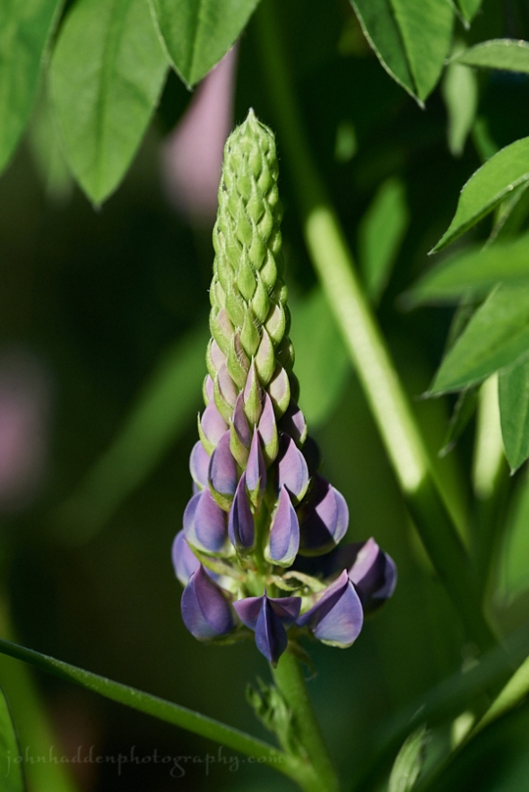
Tuesday, June 13, 2017

Lupines opening by the pond
Morning Observation:
This morning in Huntington at 7:45AM it’s currently 71 degrees under mostly cloudy skies. Winds are calm. Relative humidity is 91%, dewpoint 68, barometric pressure 29.85” and rising. Yesterday’s high was 90, and the overnight low was 61.
Forecast:
A cold front will slide southward through the region today bringing a chance for showers and thunderstorms. Behind the front temperatures will trend cooler for the remainder of the week with a period of dry weather through Thursday. More active weather returns Thursday night through the weekend with several rounds of showers and thunderstorms likely.
We’ll see partly sunny skies today with a 20% chance of showers this afternoon. Highs will be in the lower 80s with northwest winds around 10 mph. Tonight should be mostly clear and less humid with lows in the upper 40s and north winds around 10 mph.
Wednesday should be sunny and seasonably cool with highs in the upper 60s and north winds around 10 mph. Wednesday night should be clear wit lows in the mid 40s and northeast winds around 10 mph.
Thursday’s looking mostly sunny with highs in the mid 70s and light and variable winds. Thursday night should be partly cloudy with a 40% chance of showers. Lows will be in the mid 50s.
Almanac:
Last year on this date we had a high of 62 and a low of 45. We picked up 0.45″ of rain.
Burlington averages for this date are highs of 76 and lows of 55.
The record high was 94°F in 1949.
The record low was 40°F in 1923.
Sky Notes:
Sunrise: 5:07 AM EDT
Sunset: 8:37 PM EDT
Length of Visible Light: 16h 42m
Length of Day: 15h 29m
Tomorrow will be 0m30s longer.
The Moon is waning gibbous, 18 days old with 87% illumination.
Moonrise: 11:30 PM EDT
Moonset: 8:47 AM EDT
About Today’s Photo:
We have scattered groups of lupines around our pond and they’re flowering now. I’m always attracted to their stately upright blossoms.
I found out today that lupines, which are in the legume family, have been used for a food source for more than 3000 years around the Mediterranean and for more than 6000 in the Andean Highlands of South America. Users soak the seed in running water to remove most of the bitter alkaloids and then cook or toast the seeds to make them edible. Interesting what a quick look at Wikipedia will reveal!
Nikon D600, Sigma 105mm macro lens, ISO 800, f/7.1, 1/800″ exposure.
Monday, June 12, 2017


The view north from the summit of Camel’s Hump
Morning Observation:
This morning in Huntington at 7:00AM it’s currently 67 degrees under mostly cloudy skies. Winds are calm. Relative humidity is 95%, dewpoint 65, barometric pressure 29.93” and steady. Yesterday’s high was 91, and the overnight low was 61.
Forecast:
We’ve got another hot day on tap today with highs again in the mid 80s to lower 90s. A cold front will move southward across the region Tuesday morning bringing a chance for rain showers and thunderstorms. We’ll see drier and cooler conditions arrive Wednesday through the end of the work week.
We’ll see partly sunny skies today. It’ll be hot with highs in the lower 90s and southwest winds 10 to 15 mph. Tonight should be partly cloudy with a slight chance of showers until midnight, then a chance of showers and a slight chance of thunderstorms after midnight. Lows will be in the mid 60s with southwest winds 10 to 15 mph.
Tuesday should be partly sunny with a 20% chance of showers. Highs will be around 80 with northwest winds 10 to 15 mph. Tuesday night should be clear and less humid with lows in the upper 40s and north winds 10 to 15 mph.
Wednesday’s looking sunny and cool with highs in the upper 60s and north winds around 10 Wednesday night should be clear with lows in the mid 40s.
Almanac:
Last year on this date we had a high of 59 and a low of 53. We pickd up 0.12″ for rain.
Burlington averages for this date are highs of 75 and lows of 54.
The record high was 92°F in 1949.
The record low was 36°F in 1906.
Sky Notes:
Sunrise: 5:07 AM EDT
Sunset: 8:36 PM EDT
Length of Visible Light: 16h 42m
Length of Day: 15h 29m
Tomorrow will be 0m36s longer.
The Moon is waning gibbous, 17.2 days old with 93% illumination.
Moonrise: 10:52 PM EDT
Moonset: 7:51 AM EDT
About Today’s Photo:
I took a quick hike up Camel’s Hump Saturday morning. The low morning clouds had just burned off to reveal a fine 360º view. Here we’re looking north along the spine of the Green Mountains towards Bolton Mountain. Mount Mansfield is the tallest summit against the horizon in the center of the photo.
Panasonic GX8, Olympus 9-18mm lens @ 9mm, circular polarizing filter, ISO 800, f/16, 1/500″ exposure.
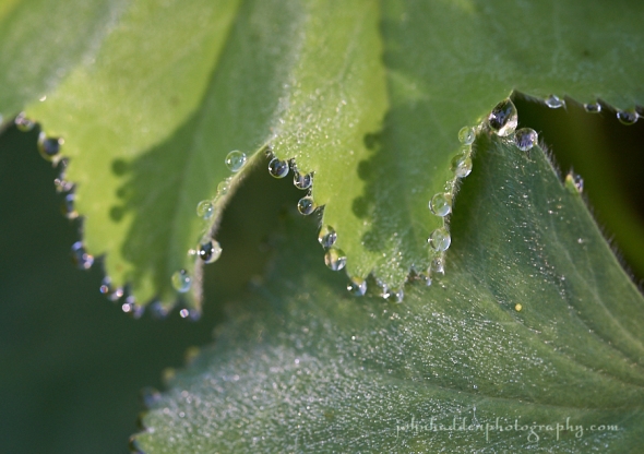
Sunday, June 11, 2017

Drops of morning dew cling to ladies mantle
Morning Observation:
This morning in Huntington at 7:40AM it’s currently 66 degrees under cloudy skies. Winds are calm. Relative humidity is 95%, dewpoint 64, barometric pressure 29.90” and steady. Yesterday’s high was 80, and the overnight low was 58.
Forecast:
A warm ridge of surface high pressure will remain over the region through Monday delivering near record highs temperatures for both today and tomorrow. The Champlain Valley may bump up into the low 90s today. Conditions will mainly be dry with a chance of showers along the international border on Monday afternoon as a surface cold front begins to sag south out of Canada.
We’ll see mostly sunny skies today with highs around 90 and southwest winds 15 to 20 mph. Tonight should be mostly clear until midnight, then become partly cloudy with a 20% chance of showers and thunderstorms after midnight. Lows will be in the mid 60s with west winds 10 to 15 mph gusting up to 25 mph until midnight, then becoming light and variable.
Monday should be mostly sunny with a slight chance of showers and thunderstorms in the morning. It’ll be hot with highs in the lower 90s and southwest winds 10 to 15 mph. Monday night should be partly cloudy with a 40% chance of showers. Lows will be in the mid 60s with southwest winds 10 to 15 mph.
Tuesday’s looking partly sunny with a 50% chance of showers. Temperatures will moderate into the upper 70s with northwest winds around 10 mph. Tuesday night should be mostly clear with lows in the lower 50s.
Almanac:
Last year on this date we had a high of 60 and a low of 42. We picked up 0.07″ of rain.
Burlington averages for this date are highs of 75 and lows of 54.
The record high was 92°F in 1947.
The record low was 35°F in 1972.
Sky Notes:
Sunrise: 5:07 AM EDT
Sunset: 8:36 PM EDT
Length of Visible Light: 16h 41m
Length of Day: 15h 28m
Tomorrow will be 0m37s longer.
The Moon is waning gibbous, 16.3 days old with 97% illumination.
Moonrise: 10:09 PM EDT
Moonset: 6:59 AM EDT
About Today’s Photo:
The leaves of ladies mantle have serrations that seem to attract moisture. After rains or even just a moderate dew, tiny beads of water will cling to the margins. Minute hairs across the surface of the leaves enhance the effect.
Nikon D600, Sigma 105mm macro lens, ISO 800, f/10, 1/125″ exposure.
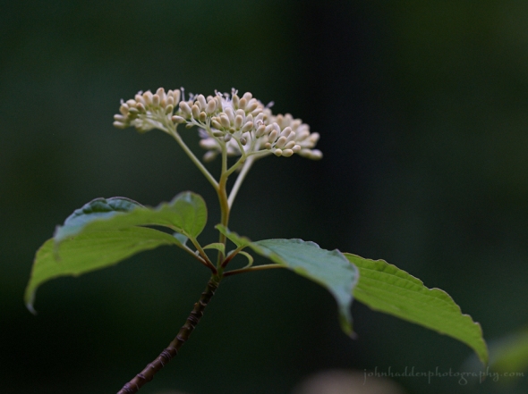
Saturday, June 10, 2017

Pagoda dogwood blossoms about to burst
Morning Observation:
This morning in Huntington at 7:20AM it’s currently 55 degrees under mostly cloudy skies. Winds are calm. Relative humidity is 98%, dewpoint 55, barometric pressure 29.91” and rising slowly. We picked up 0.04” of rain in the past 24hrs. Yesterday’s high was 74, and the overnight low was 48.
Forecast:
A weak shortwave trough aloft will swing through the region today sparking a few showers and an isolated thunderstorm or two. Otherwise mainly dry weather and warming temperatures are expected into Monday. Scattered showers and thunderstorms are expected by Monday afternoon into Monday night as a cold front drops through the area.
We’ll see mostly cloudy skies this morning, then partly sunny skies with a slight chance of showers and thunderstorms this afternoon. Highs will be in the upper 70s with light and variable winds, becoming southwesterlt around 10 mph this afternoon. Chance of rain is 20%. Tonight should be partly cloudy with lows in the lower 60s and south winds 10 to 15 mph.
Sunday should be sunny with highs in the mid 80s and southwest winds 10 to 15 mph gusting up to 30 mph. Sunday night should be partly cloudy with lows in the mid 60s and west winds 15 to 20 mph.
Monday’s looking partly sunny with a 50% chance of showers and thunderstorms. Highs will be in the upper 80s with southwest winds 10 to 15 mph. Monday night should be partly cloudy with a 50% chance of showers. Lows will in the mid 60s.
Almanac:
Last year on this date we had a high of 66 and a low of 45.
Burlington averages for this date are highs of 75 and lows of 54.
The record high was 93°F in 1974.
The record low was 34°F in 1912.
Sky Notes:
Sunrise: 5:07 AM EDT
Sunset: 8:35 PM EDT
Length of Visible Light: 16h 40m
Length of Day: 15h 27m
Tomorrow will be 0m43s longer.
The Moon is waning gibbous, 15.4 days old with 99% illumination.
Moonrise: 9:23 PM EDT
Moonset: 6:12 AM EDT
About Today’s Photo:
Pagoda dogwood is flowering now. I shot this particular tree along Fargo Brook two days ago and the flowers have opened up now. These shade loving trees add a splash of white to the understory of the woods.
Nikon D600, Sigma 105mm macro, ISO 1250, f/5, 1/100″ exposure.
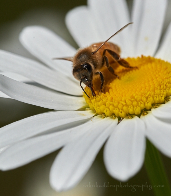
Friday, June 9, 2017

A bee works a daisy by the pond
Morning Observation:
This morning in Huntington at 7:15AM it’s currently 57 degrees under mostly cloudy skies. Winds are calm. Relative humidity is 96%, dewpoint 56, barometric pressure 29.66” and steady. Yesterday’s high was 82, and the overnight low was 52.
Forecast:
The combination of an offshore low and a weak cold front dropping through the region from Ontario will lead to a few showers and isolated thunderstorms today into Saturday. Warm, summerlike conditions arrive Sunday into Monday of next week before a cold front brings cooler weather by the middle of next week.
We’ll see mostly cloudy skies with a 50% chance of showers and a slight chance of thunderstorms today. Highs will be in the lower 70s with light and variable winds, becoming westerly around 10 mph this afternoon. Tonight should be partly cloudy with a 20% slight chance of showers and thunderstorms until midnight. Lows will be in the lower 50s with northwest winds 10 to 15 mph until midnight, becoming light and variable.
Saturday should be partly sunny with a 20% chance of showers in the afternoon. Highs will be in the upper 70s with light and variable winds, becoming southwesterly around 10 mph in the afternoon. Saturday night should be partly cloudy with lows in the mid 60s and southwest winds 10 to 15 mph.
Sunday’s looking partly sunny with highs in the lower 80s and southwest winds 10 to 15 mph gusting up to 30 mph. Sunday night should be partly cloudy with lows in the mid 60s.
Almanac:
Last year on this date we had a high of 52 and a low of 44. We picked up 0.28″ of rain.
Burlington averages for this date are highs of 75 and lows of 54.
The record high was 93°F in 1933.
The record low was 37°F in 1983.
Sky Notes:
Sunrise: 5:07 AM EDT
Sunset: 8:34 PM EDT
Length of Visible Light: 16h 39m
Length of Day: 15h 27m
Tomorrow will be 0m47s longer.
The Moon is the full “Strawberry” moon (Northeast Native American)
14.5 days old with 100% illumination.
Moonrise: 8:33 PM EDT
Moonset: 5:30 AM EDT
Other names for this month’s full moon include: “Rose” (Colonial American), “Flower” (English), “Horse” (Celtic), “Dyad” (Medieval Wiccan), and “Planting” (Neo Pagan Wiccan).
About Today’s Photo:
We have a lovely patch of daisies blooming at the edge of the pond. As I stalked by with my camera, I noticed this small solitary bee working the flower. It was quite patient with me allowing while I clicked off several shots.
Nikon D600, Sigma 105mm macro lens, ISO 800, f/13, 1/2000″ exposure.
Thursday, June 8, 2017

Iris in bloom in our back garden
Morning Observation:
This morning in Huntington at 7:15AM it’s currently 53 degrees under clear skies. Winds are calm. Relative humidity is 98%, dewpoint 52, barometric pressure 30.03” and steady. Yesterday’s high was 75, and the overnight low was 45.
Forecast:
We’ve got another nice day is on tap today, with temperatures warmer than yesterday in the mid 70s to low 80s. Weak surface instability will hold out the threat of a few isolated terrain driven showers possible across the Adirondacks during the afternoon. A coastal low may bring a few showers and thunderstorms to eastern area Friday morning into the afternoon, and a shortwave trough moving in from the west will bring the threat of a few showers and thunderstorms Friday afternoon into the evening. Building heat will move in for Sunday into next week
with several days well into the 80s and possibly 90s along with daily chances for showers and thunderstorms.
We’ll see mostly sunny skies today with highs around 80 and light and variable winds. Tonight should be partly cloudy until midnight, then become mostly cloudy with a 20% chance of showers after midnight. Lows will be in the mid 50s with light and variable winds.
Friday should be mostly cloudy with a 50% chance of showers and a slight chance of thunderstorms. Highs will be in the mid 70s with west winds around 10 mph. Friday night should be partly cloudy with a 40% chance of showers. Lows will be in the mid 50s with west winds around 10 mph.
Saturday’s looking partly sunny with a 30% chance of showers. Highs will be in the upper 70s with southwest winds around 10 mph. Saturday night should be partly cloudy with lows in the lower 60s.
Almanac:
Last year on this date we had a high of 64 and a low of 46. We picked up 0.37″ of rain.
Burlington averages for this date are highs of 74 and lows of 53.
The record high was 91°F in 1984.
The record low was 36°F in 1960.
Sky Notes:
Sunrise: 5:08 AM EDT
Sunset: 8:34 PM EDT
Length of Visible Light: 16h 38m
Length of Day: 15h 26m
Tomorrow will be 0m51s longer.
The Moon is waxing gibbous, 13.6 days old with 98% illumination.
Moonrise: 7:39 PM EDT
Moonset: 4:53 AM EDT
About Today’s Photo:
Isises are in bloom! We have several varieties of iris growing on our property, and this is one of the earlier ones. Not sure of its variety, but it smells sweet and has a lovely form to it!
Nikon D600, Sigma 105mm macro lens, ISO 1250, f/3.5, 1/2000″ exposure.
Wednesday, June 7, 2017

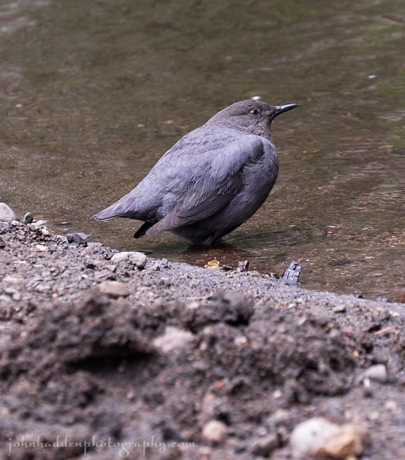
A water ouzel keeps an eye on me…
Morning Observation:
This morning in Huntington at 7:25AM it’s currently 47 degrees under mostly clear skies. Winds are calm. Relative humidity is 98%, dewpoint 46, barometric pressure 30.03” and rising. We picked up 0.51”of rain in the past 24hrs. Yesterday’s high was 55, and the overnight low was 39.
Forecast:
It looks like we’ve finally left behind out Scottish weather. High pressure currently building over the region will deliver a pleasant late Spring day with sunny skies and temperatures warming into the 70s. Low pressure off the Atlantic coast will fire up a few terrain driven showers and thunderstorms Thursday, and another trough of low pressure will move through on Friday bringing the chance for more showers and thunderstorms. A building heat bubble is expected to move in Sunday into next week bringing several days of temperatures well into the 80s and possibly 90s.
We’ll see areas of dense fog this morning giving way to mostly sunny. Highs will be in the lower 70s with light and variable winds. Tonight should be mostly clear with lows in the lower 50s and light and variable winds.
Thursday should be mostly sunny with a 30% chance of showers and a slight chance of thunderstorms in the afternoon. Highs will be around 80 with light and variable winds. Thursday night should be partly cloudy with a 30% chance of showers. Lows will be in the mid 50s with light and variable winds.
Friday’s looking partly sunny with a 50% chance of showers. Highs will be in the lower 70s with west winds around 10 mph. Friday night should be partly cloudy with a 50% chance of showers. Lows will be in the lower 50s.
Almanac:
Last year on this date we had a high of 72 and a low of 50. We picked up 0.03″ of rain.
Burlington averages for this date are highs of 74 and lows of 53.
The record high was 94°F in 1999.
The record low was 35°F in 1958.
Sky Notes:
Sunrise: 5:08 AM EDT
Sunset: 8:33 PM EDT
Length of Visible Light: 16h 37m
Length of Day: 15h 25m
Tomorrow will be 0m55s longer.
The Moon is waxing gibbous, 12.7 days old with 95% illumination.
Moonrise: 6:43 PM EDT
Moonset: 4:19 AM EDT
About Today’s Photo:
While hiking along the East Branch of the Jemez River in New Mexico last week, we came across a pair of water ouzels (a.k.a. American dippers) hunting in the current. It turns out the two birds were hanging out near their nest which was up in a rock wall just above the water (another photographer alerted us to the fact.) Ouzels hunt insects and such in streams and have special adaptations to their eyes and nostrils so that they can remain under water for short periods of time to hunt.
Panasonic GX8, Lumix 14-140mm lens @ 130mm, ISO 800, f/6.3, 1/320″ exposure
Tuesday, June 6, 2017

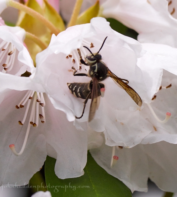
A bald-faced hornet works a rhododendron blossom
Morning Observation:
This morning in Huntington at 7:25AM it’s currently 50 degrees and raining lightly under overcast skies. Winds are calm. Relative humidity is 92%, dewpoint 48, barometric pressure 29.83” and rising slowly. We picked up 0.19” of rain in the past 24hrs. Yesterday’s high was 59, and the overnight low was 50.
Forecast:
Our “Scottish” weather continues… A slow moving upper level trough of low pressure will continue to sag southward delivering cool and wet conditions to the today before high pressure builds over the region tonight through Wednesday. Outside of a few mountain showers, Thursday will be dry as well, but the
threat for showers and thunderstorms returns for Friday through the weekend. Temperatures will moderate back towards seasonal levels by Wednesday with even warmer—perhaps hot—weather arriving for the weekend along with the possibility of some severe thunderstorms. Stay tuned!
We’ll see showers today with near steady temperature in the lower 50s with east winds around 10 mph. Chance of rain is 90%. Tonight should be mostly cloudy with occasional showers mainly until midnight. Lows will be in the mid 40s with light and variable winds. Chance of rain is 80%.
Wednesday should be partly sunny with highs around 70 and light and variable winds. Wednesday night should be clear with lows around 50 and light and variable winds.
Thursday’s looking partly sunny with highs in the upper 70s and southwest winds around 10 mph. Thursday night should be partly cloudy with a 30% chance of showers. Lows will be in the lower 50s.
Almanac:
Last year on this date we had a high of 77 and a low of 52. We picked up 1.70″ of rain.
Burlington averages for this date are highs of 74 and lows of 53.
The record high was 94°F in 1925.
The record low was 37°F in 1964.
Sky Notes:
Sunrise: 5:08 AM EDT
Sunset: 8:33 PM EDT
Length of Visible Light: 16h 36m
Length of Day: 15h 24m
Tomorrow will be 0m59s longer.
The Moon is waxing gibbous, 11.8 days old with 90% illumination.
Moonrise: 5:45 PM EDT
Moonset: 3:49 AM EDT
About Today’s Photo:
We returned from our sojourn out west to find the rhododendrons and azalea next to the house in magnificent full bloom! We’ve never seen them so bright and lush (maybe the damp, Scottish weather has something to do with it…) Pollinators are taking advantage of the bounty as several species of flies, bumble bees, and bald-faced hornets have been busily at work sipping the nectar. Bald-faced hornets are not truly hornets. They’re in the same family as yellowjacket wasps. If you find one of their large paper nests, steer clear as they’ll protect it aggressively!
Panasonic GX8, Lumix 100-300mm lens @ 300mm, ISO 800, f/8, 1/3200″ exposure.
