Monday, August 31, 2015
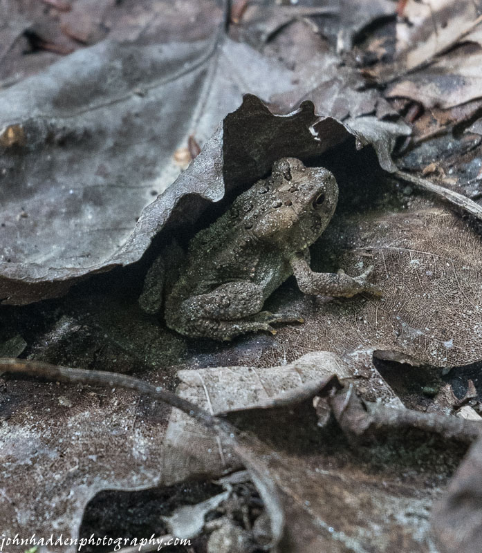
This American toad was perfectly camouflaged in the leaf litter near Cobb Brook
Morning Observation:
This morning in Huntington at 7:00AM it’s currently 57 degrees under mostly clear skies. Winds are calm. Relative humidity is 99%, dewpoint 57, barometric pressure 29.94”. Yesterday’s high was 79, and the overnight low was 56.
Forecast:
An upper level ridge of high pressure parked over the eastern US will provide dry weather and above normal temperatures through the upcoming week. We’ll see partly sunny skies today with highs in the lower 80s and west winds 10 to 15 mph. Tonight should be mostly clear with lows in the upper 50s and northwest winds around 10 mph until midnight, becoming light and variable.
Tuesday should be sunny with highs in the mid 80s and light and variable winds. Tuesday night should be mostly clear with lows in the lower 60s and light and variable winds.
Wednesday’s looking sunny and warmer still with highs in the upper 80s and west winds around 10 mph. Wednesday night should be mostly clear with lows in the mid 60s.
Almanac:
Last year on this date we had a high of 75 and a low of 65.
Burlington norms for this date are 76 and lows of 56.
The record high was 92°F in 2010 (we had a high of 89).
The record low was 35°F in 1965.
Sky Notes:
Sunrise: 6:13 AM EDT
Sunset: 7:30 PM EDT
Length of Visible Light: 14h 17m
Length of Day: 13h 17m
Tomorrow will be 2m57s shorter.
The Moon is waning gibbous, 16d 20h old with 96% illumination.
Moonrise: 8:38 PM EDT
Moonset: 8:25 AM EDT
About Today’s Photo:
Watch where you step! If this little toad hadn’t moved as I was walking by I would have completely missed him (or squashed him!) His coloration perfectly matched the leaf litter he was hiding in!
Panasonic Lumix GM5, 12-32mm lens @ 28mm, ISO 500, f/5.5, 1/60″ exposure.
Sunday, August 30, 2015

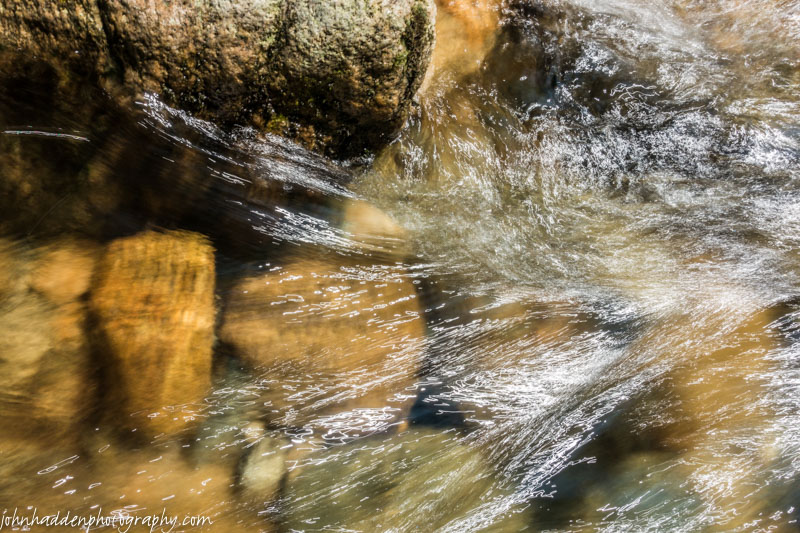
Low water sluices through carved stone in Cobb Brook
Morning Observation:
This morning in Huntington at 7:50AM it’s currently 60 degree under mostly sunny skies. Winds are calm. Relative humidity is 99%, dewpoint 60, barometric pressure 30.06” and rising slowly. Yesterday’s high was 77, and the overnight low was 59.
Forecast:
A middle-level shortwave trough will keep clouds and a slight chance for showers over the region today with clouds diminishing this afternoon and evening. Any morning clouds should give way to partly sunny skies this afternoon. Highs will be in the upper 70s with light and variable winds. Tonight should be partly cloudy with lows around 60 and light and variable winds, becoming southwesterly around 10 mph after midnight.
Monday should be partly sunny and warmer with highs in the lower 80s and southwest winds around 10 mph, becoming westerly and gusting up to 25 mph in the afternoon. Monday night should be mostly clear with lows in the upper 50s and northwest winds around 10 mph.
Tuesday’s looking mostly sunny with highs in the lower 80s and light and variable winds. Tuesday night should be clear with lows in the lower 60s.
Almanac:
Last year on this date we had a high of 77 and a low of 51.
Burlington norms for this date are 77 and lows of 56.
The record high was 93°F in 1991.
The record low was 39°F in 1965.
Sky Notes:
Sunrise: 6:12 AM EDT
Sunset: 7:32 PM EDT
Length of Visible Light: 14h 20m
Length of Day: 13h 20m
Tomorrow will be 2m55s shorter.
The Moon is waning gibbous, 15d 21h old with 99% illumination.
Moonrise: 8:03 PM EDT
Moonset: 7:09 AM EDT
About Today’s Photo:
I’ve been putting a new camera through its paces the past two days, visiting favorite haunts and subjects. Cobb Brook down in Hanksville offers lovely sculpted rocks that, even in low water, make for some lovely long exposure shooting. You can see a few more of yesterday’s shots on my Photograph Blog.
Panasonic Lumix GM5, 12-32mm lens @ 12mm, ISO 200, f/22, 4″ exposure.
Saturday, August 29, 2015

A gull takes in the view to the west off the Colchester causeway
Morning Observation:
This morning in Huntington at 7:15AM it’s currently 52 degrees under mostly cloudy skies. Winds are calm. Relative humidity is 99%, dewpoint 52, barometric pressure 30.18” and rising slowly. Yesterday’s high was 75, and the overnight low was 50.
Forecast:
High pressure will continue to deliver dry and seasonable weather today. We’ll see partly sunny skies with highs in the upper 70s and light and variable winds. becoming southwesterly around 10 mph this afternoon. Tonight should be mostly cloudy with lows in the upper 50s and southwest winds around 10 mph.
A weak disturbance will slide through on Sunday with partly sunny skies and a 20% chance of showers. Highs will be around 80 with light and variable winds, becoming westerly around 10 mph in the afternoon. Sunday night should be mostly clear with lows in the upper 50s and southwest winds around 10 mph.
Monday’s looking mostly sunny and warmer with highs in the lower 80s and west winds 10 to 15 mph gusting up to 25 mph. Monday night should be mostly clear with lows in the lower 60s.
Almanac:
Last year on this date we had a high of 74 and a low of 52.
Burlington norms for this date are highs of 77 and lows of 57.
The record high was 92°F in 1953.
The record low was 41°F in 1941.
Sky Notes:
Sunrise: 6:11 AM EDT
Sunset: 7:34 PM EDT
Length of Visible Light: 14h 23m
Length of Day: 13h 22m
Tomorrow will be 2m55s shorter.
The Moon is the full “Sturgeon” Moon (Northeast Native American)
14d 20h old with 100% illumination.
Moonrise: 7:26 PM EDT
Moonset: 5:53 AM EDT
Other names for this month’s full moon include: “Dog Days” (Colonial American), “Grain” (English), “Dispute” (Celtic), “Wyrt” (Medieval Wiccan), and “Lightning” (Neo-Pagan Wiccan).
About Today’s Photo:
Another shot from our little sojourn up the Colchester causeway. This gull was nice enough to pose for me as it surveyed the scene across Lake Champlain.
Sony HX90V, ISO 80, f/6.3, 1/800″ exposure.
Friday, August 28, 2015

Camel’s Hump to the App Gap as viewed from the Colchester causeway.
Morning Observation:
This morning in Huntington at 7:409AM it’s currently 56 degrees under clear skies. Winds are calm. Relative humidity is 99%, dewpoint 56, barometric pressure 30.16” and rising. We picked up 0.11” of rain in the past 24hrs. Yesterday’s high was 71, and the overnight low was 52.
Forecast:
We’ve got a lovely couple of days on tap courtesy of high pressure which is currently building into the region. We’ll see mostly sunny skies today with highs in the mid 70s and light and variable winds. Tonight should be clear with lows in the lower 50s and light and variable winds.
Saturday should be partly sunny and warmer with highs in the upper 70s and light and variable winds. Saturday night should be partly cloudy with lows in the upper 50s and light and variable winds.
Sunday should be partly sunny with highs around 80 and west winds around 10 mph. Sunday night should be partly cloudy with lows in the lower 60s.
Almanac:
Last year on this date we had a high of 69 and a low of 55.
Burlington norms for this date are highs of 77 and lows of 57.
The record high was 94°F in 1952.
The record low was 39°F in 1925.
Sky Notes:
Sunrise: 6:09 AM EDT
Sunset: 7:35 PM EDT
Length of Visible Light: 14h 26m
Length of Day: 13h 25m
Tomorrow will be 2m55s shorter.
The Moon is waxing gibbous, 13d 20h old with 97% illumination.
Moonrise: 6:48 PM EDT
Moonset: 4:39 AM EDT
About Today’s Photo:
Robin & I pedaled along the Burlington Bike Path yesterday afternoon out to the Colchester Causeway. The views were spectacular all the way around the compass. I snapped this nice view across the water of our “home range” of Camel’s Hump from the Winooski River to the Appalachian Gap.
Sony HX90V, IOS 80, f/5.6, 1/500″ exposure.
Thursday, August 27, 2015

Mountain ash berries with Camel’s Hump in the background
Morning Observation:
This morning in Huntington at 7:25AM it’s currently 57 degrees under overcast skies. Winds are calm. Relative humidity is 99%, dewpoint 57, barometric pressure 29.98” and rising. Yesterday’s high was 74, and the overnight low was 53.
Forecast:
A very slow moving upper level trough of low pressure will move across the region today delivering cloudy skies and a 20% chance of scattered showers this morning. The trough should move to our east later in the day allowing for partly sunny skies. Highs will be in the lower 70s with west winds around 10 mph. Tonight should be partly cloudy with lows in the lower 50s and northwest winds around 10 mph until midnight, becoming light and variable.
High pressure will build in Friday brining mostly sunny skies with highs in the lower 70s and light and variable winds. Friday night should be mostly clear with lows in the lower 50s and light and variable winds.
Saturday’s looking partly sunny with highs in the upper 70s and light and variable winds. Saturday night should be partly cloudy with lows around 60.
Almanac:
Last year on this date we had a high of 82 and a low of 59.
Burlington norms for this date are highs of 77 and lows of 57.
The record high was 95°F in 1948.
The record low was 40°F in 1969.
Sky Notes:
Sunrise: 6:08 AM EDT
Sunset: 7:37 PM EDT
Length of Visible Light: 14h 29m
Length of Day: 13h 28m
Tomorrow will be 2m53s shorter.
The Moon is waxing gibbous, 12d 20h old with 92% illumination.
Moonrise: 6:06 PM EDT
Moonset: 3:29 AM EDT
About Today’s Photo:
I came across a berry-laden mountain ash tree along Shaker Mountain Road yesterday afternoon. The view of Camel’s Hump in the background made for a nice juxtaposition!
Sony RX100m3, ISO 125, f/5.6, 1/320″ exposure.
Wednesday, August 26, 2015

A furtive warbler lurks in the brush around spruce trees. Can anyone identify it?
Morning Observation:
This morning in Huntington at 7:05AM it’s currently 53 degrees under mostly clear skies. Winds are calm. Relative humidity is 98%, dewpoint 52, barometric pressure 29.94” and rising. Yesterday’s high was 80, and the overnight low was 53.
Forecast:
Low pressure currently centered over James Bay in Canada will continue to generate the potential for afternoon convection driven showers. We’ll see partly sunny skies with a 20% chance of showers this afternoon. Highs will be in the mid 70s with light and variable winds, becoming northwesterly around 10 mph this afternoon. Tonight should be partly cloudy with a slight chance of showers until midnight. Lows will be in the mid 50s with light and variable winds.
Thursday should be mostly cloudy with a chance of showers in the morning, then partly sunny with a slight chance of showers in the afternoon. Highs will be in the lower 70s with light and variable winds, becoming northwesterly around 10 mph in the afternoon. Chance of rain is 30%. Thursday night should be partly cloudy with lows in the lower 50s and northwest winds around 10 mph.
Friday’s looking mostly sunny with highs in the mid 70s and light and variable winds. Friday night should be mostly clear with lows in the mid 50s.
Almanac:
Last year on this date we had a high of 82 and a low of 56.
Burlington norms for this date are highs of 78 and lows of 57.
The record high was 96°F in 1948.
The record low was 40°F in 1987.
Sky Notes:
Sunrise: 6:07 AM EDT
Sunset: 7:39 PM EDT
Length of Visible Light: 14h 32m
Length of Day: 13h 31m
Tomorrow will be 2m54s shorter.
The Moon is waxing gibbous, 11d 20h old with 85% illumination.
Moonrise: 5:20 PM EDT
Moonset: 2:24 AM EDT
About Today’s Photo:
Alright all you bird identifiers out there, what kind of warbler is this? Another Nashville? Orange-crowned? He was lurking in the brush beneath the spruce trees in our front yard.
Nikon D600, Sigma 120-400mm lens @ 400mm, ISO 640, f/7.1, 1/400″ exposure.
oiuAl
Tuesday, August 25, 2015

a chickadee feeds in the spruce trees in our front yard
Morning Observation:
This morning in Huntington at 6:50AM it’s currently 59 degrees under mostly clear skies. Winds are calm. Relative humidity is 94%, dewpoint 57, barometric pressure 29.82”. Yesterday’s high was 82, and the overnight low was 59.
Forecast:
A large-scale upper level low just north of the Great Lakes this morning will remain the primary weather maker for our region through Thursday as it moves slowly eastward and gradually weakens over time. An associated cold front is crossing our region this morning, kicking off showers to our south. The forecast calls for cloudy skies (though I don’t see ’em…) with a chance of showers and a slight chance of thunderstorms this morning, then partly sunny skies with a slight chance of showers and thunderstorms this afternoon. Highs will be in the upper 70s with light and variable winds. Chance of rain is 30%. Tonight should be partly cloudy with lows in the upper 50s and light and variable winds.
Wednesday should be partly sunny with a 30% chance of showers in the afternoon. Highs will be in the mid 70s with light and variable winds. Wednesday night should be partly cloudy with a 30% chance of showers. Lows will be in the mid 50s with light and variable winds.
Thursday’s looking partly sunny with a 40% chance of showers. Highs will be in the lower 70s with west winds around 10 mph. Thursday night should be partly cloudy with lows in the lower 50s.
Almanac:
Last year on this date we had a high of 84 and a low of 53.
Burlington norms for this date are highs of 78 and lows of 57.
The record high was 97°F in 1947.
The record low was 39°F in 1942.
Sky Notes:
Sunrise: 6:06 AM EDT
Sunset: 7:40 PM EDT
Length of Visible Light: 14h 35m
Length of Day: 13h 34m
Tomorrow will be 2m52s shorter.
The Moon is waxing gibbous, 10d 20h old with 76% illumination.
Moonrise: 4:30 PM EDT
Moonset: 1:25 AM EDT
About Today’s Photo:
Periodically through the day, a chatter of chickadees will move into the spruce trees in our front yard to feed on the cones. They’re often joined by titmice and warblers.
Nikon D600, Sigma 120-400mm lens @ 400mm, ISO 640, f/7.1, 1/800″ exposure.
Monday, August 24, 2015

Thistle flowers on their way to becoming burs…
Morning Observation:
This morning in Huntington at 7:50AM it’s currently 66 degrees under mostly cloudy skies. Winds are calm. Relative humidity is 99%, dewpoint 65, barometric pressure 29.89”. Yesterday’s high was 82, and the overnight low was 61.
Forecast:
An upper level low pressure system will move over the Great Lakes region this week delivering unsettled weather in the northeast through the work week. A slow moving cold front will cross the region from today through Tuesday kicking off scattered showers. We’ll see partly sunny skies today with highs in the lower 80s and south winds around 10 mph. Tonight should be partly cloudy until midnight, then become mostly cloudy with a chance of showers and a slight chance of thunderstorms. Lows will be in the lower 60s with south winds around 10 mph until midnight, becoming light and variable. Chance of rain is 40%.
Tuesday should start off cloudy in the morning, then become partly sunny with a 50% chance of showers with a slight chance of thunderstorms. Highs will be in the mid 70s with light and variable winds. Tuesday night should be partly cloudy with a 40% chance of showers. Lows will be in the upper 50s with light and variable winds.
Wednesday should be partly sunny with a 30% chance of showers. Highs will be in the mid 70s with light and variable winds. Wednesday night should be partly cloudy with a 30% chance of showers. Lows will be in the mid 50s.
Almanac:
Last year on this date we had a high of 80 and a low of 52.
Burlington norms for this date are highs of 78 and lows of 58.
The record high was 97°F in 1947.
The record low was 40°F in 1923.
Sky Notes:
Sunrise: 6:05 AM EDT
Sunset: 7:42 PM EDT
Length of Visible Light: 14h 38m
Length of Day: 13h 37m
Tomorrow will be 2m51s shorter.
The Moon is waxing gibbous, 9d 21h old with 67% illumination.
Moonrise: 3:36 PM EDT
Moonset: 12:34 AM EDT
About Today’s Photo:
The thistles have been blooming for a while now and are well on their way to becoming burs.
Nikon D600, Sigma 105mm macro, ISO 800, f/13, 1/250″ exposure.
Sunday, August 23, 2015

A white Asian lily by Fargo Brook
Morning Observation:
This morning in Huntington at 9:15AM it’s currently 62 degrees under mostly cloudy skies. Winds are calm. Relative humidity is 98%, dewpoint 61, barometric pressure 30.08″. Yesterday’s high was 78, and the overnight low was 52.
Forecast:
Weak high pressure over the region will deliver partly sunny skies this morning, then mostly cloudy skies with a 20% chance of showers this afternoon as the cold front that swung through Thursday night retrogrades back over the area a bit. Highs will be in the upper 70s to lower 80s with light and variable winds. Tonight should be partly cloudy with a 20% chance of showers until midnight. Lows will be in the lower 60s with light and variable winds, becoming southeasterly around 10 mph after midnight.
Monday should be partly sunny with a 20% chance of showers and thunderstorms in the afternoon as low pressure approaches from the west. Highs will be in the lower 80s with light and variable winds. Monday night should be partly cloudy with a 40% chance of showers. Lows will be in the lower 60s with southeast winds around 10 mph.
Tuesday showers are likely. Highs will be in the mid 70s with light and variable winds. Chance of rain is 70%. Tuesday night should be partly cloudy with a 50% chance of showers. Lows will be in the upper 50s.
Almanac:
Last year on this date we had a high of 76 and a low of 54. We picked up 0.03″ of rain.
Burlington norms for this date are highs of 78 and lows of 58.
The record high was 93°F in 1947.
The record low was 43°F in 1988.
Sky Notes:
Sunrise: 6:04 AM EDT
Sunset: 7:44 PM EDT
Length of Visible Light: 14h 41m
Length of Day: 13h 40m
Tomorrow will be 2m51s shorter.
The Moon is waxing gibbous, 8d 22h old with 58% illumination.
Moonrise: 2:39 PM EDT
No Moon Set
About Today’s Photo:
Along with the very colorful Asian lilies that Robin planted along Fargo Brook (see yesterday’s post), she also planted some lovely white ones. I like the puckery texture of the petals…
Nikon D600, Sigma 105mm macro, ISO 800, f/20, 1/80″ exposure
Saturday, August 22, 2015

Asian lilies blooming by the brook
Morning Observation:
This morning in Huntington at 8:40AM it’s currently 63 degrees under partly cloudy skies. Winds are calm. Relative humidity is 93%, dewpoint 61, barometric pressure 30.15” and rising. We picked up 0.09” of rain in the past 24hrs. Yesterday’s high was 80, and the overnight low was 54.
Forecast:
We have a lovely day on tap courtesy of high pressure currently building into the region this morning. We’ll see mostly sunny skies with highs in the upper 70s and light and variable winds. Tonight should be mostly clear with lows in the upper 50s and light and variable winds.
The high will move to our east on Sunday allowing the cold front that’s still lingering off the New England coast to retrograde a bit and bring some showers back into the region. We’ll see partly sunny skies with a slight chance of showers in the morning, then an increasing chance of showers with a slight chance of thunderstorms in the afternoon. Highs will be around 80 with light and variable winds. Chance of rain is 40%. Sunday night should be partly cloudy with a 30% chance of showers. Lows will be in the mid 60s with southeast winds around 10 mph.
Monday’s looking partly sunny with a 40% chance of showers. Highs will be in the lower 80s with south winds around 10 mph. Monday night should be partly cloudy with a 50% chance of showers. Lows will be in the lower 60s.
Almanac:
Last year on this date we had a high of 64 and a low of 59. We picked up 0.21″ of rain.
Burlington norms for this date are highs of 78 and lows 58.
The record high was 90°F in 1916.
The record low was 39°F in 1982.
Sky Notes:
Sunrise: 6:03 AM EDT
Sunset: 7:46 PM EDT
Length of Visible Light: 14h 44m
Length of Day: 13h 43m
Tomorrow will be 2m50s shorter.
The Moon is in its first quarter, 7d 21h old with 47% illumination.
Moonrise: 1:41 PM EDT
Moonset: 11:50 PM EDT
About Today’s Photo:
Robin bought some Asian lily bulbs at the Garden Show this past winter and planted them in a small bed next to Fargo Brook this spring. I’d say she did well!
Nikon D600, Sigma 105mm macro, ISO 800, f/20, 1/40″ exposure.
Friday, August 21, 2015

A yellow warbler visits us on the front porch
Morning Observation:
This morning in Huntington at 7:15AM it’s currently 63 degrees and raining lightly under overcasts skies. Winds are calm. Relative humidity is 97%, dewpoint 63, barometric pressure 29.98” and rising. We picked up 0.26” of rain overnight. Yesterday’s high was 84, and the overnight low was 63.
Forecast:
The slow moving cold front responsible for our current showers is pretty much directly over us this morning and will move slowly eastward during the day. We’ll see cloudy skies with occasional showers this morning, then partly sunny skies with scattered showers this afternoon. It will be cooler with highs in the upper 70s and light and variable winds. Chance of rain is 90%. Tonight should be partly cloudy with lows in the upper 50s and light and variable winds.
High pressure will slowly build in for Saturday brining partly sunny skies with highs in the upper 70s and light and variable winds. Saturday night should be partly cloudy with lows around 60 and light and variable winds.
A weak trough will slide through on Sunday bringing partly sunny skies with a 40% chance of showers. Highs will be in the upper 70s with light and variable winds. Sunday night should be partly cloudy with a 30% chance of showers. Lows will be in the mid 60s.
Almanac:
Last year on this date we had a high of 68 and a low of 60. We picked up 0.16″ of rain.
Burlington norms for this date are highs of 79 and lows of 58.
The record high was 93°F in 1945.
The record low was 43°F in 1934.
Sky Notes:
Sunrise: 6:01 AM EDT
Sunset: 7:47 PM EDT
Length of Visible Light: 14h 47m
Length of Day: 13h 45m
Tomorrow will be 2m50s shorter.
The Moon is a waxing crescent, 6d 20h old with 37% illumination.
Moonrise: 12:43 PM EDT
Moonset: 11:12 PM EDT
About Today’s Photo:
I was making dinner the other evening when I heard a bump on the window by the sink and caught a fleeting glimpse of a bird fluttering down. Looking out, I saw this yellow warbler sitting on the arm of one of our front porch chairs. It was stunned but still alive. I went cautiously outside to take a closer look (and to make sure the cats hadn’t heard it as well…) Gradually the little bird came back to its senses, but not before allowing me to get close enough to snap several shots with my iPhone. It shortly took off into the trees seemingly none the worse for wear…
Thursday, August 20, 2015

An orb weaver spider in our garage!
Morning Observation:
This morning in Huntington at 7:50AM it’s currently 69 degrees under mostly clear skies. Winds are calm. Relative humidity is 89%, dewpoint 63, barometric pressure 29.98”. Yesterday’s high was 87, and the overnight low was 64.
Forecast:
We’ve got one more day of above normal temperature in store for us before a cold front moves in tonight bringing showings and thunderstorms. We’ll see sunny skies today with highs in the mid 80s and south winds 10 to 15 mph gusting up to 30 mph.
Tonight should be partly cloudy until midnight, then become mostly cloudy with numerous showers with isolated thunderstorms after midnight. Locally heavy rainfall possible after midnight. Lows will be in the mid 60s with south winds 10 to 15 mph gusting up to 30 mph. Chance of rain is 70%.
Friday will bring numerous showers with isolated thunderstorms. Locally heavy rainfall possible in the morning. Highs will be in the mid 70s with south winds around 10 mph in the morning, becoming light and variable. Chance of rain is 70%. Friday night should be partly cloudy with scattered showers. Lows will be around 60 with light and variable winds. Chance of rain is 50%.
Saturday’s looking partly sunny with highs in the mid 70s and light and variable winds. Saturday night should be partly cloudy with lows in the lower 60s.
Almanac:
Last year on this date we had a high of 82 and a low of 47.
Burlington norms for this date are highs of 79 and lows of 58.
The record high was 94°F in 1916.
The record low was 42°F in 1953.
Sky Notes:
Sunrise: 6:00 AM EDT
Sunset: 7:49 PM EDT
Length of Visible Light: 14h 50m
Length of Day: 13h 48m
Tomorrow will be 2m47s shorter.
The Moon is a waxing crescent, 5d 21h old with 28% illumination.
Moonrise: 11:44 AM EDT
Moonset: 10:39 PM EDT
About Today’s Photo:
We see a lot of these orb weaver spiders building webs near the windows in our garage. This one was quite large—maybe 3″ including its legs.
Sony RX100m3, ISO 1250, f/2.8, 1/60″ exposure.
Wednesday, August 19, 2015
Rushing water paints light scribbles in Texas Brook
Morning Observation:
This morning in Huntington at 7:10AM it’s currently 66 degrees under mostly clear skies. Winds are calm. Relative humidity is 99%, dewpoint 66, barometric pressure 29.98” and rising slowly. Yesterday’s high was 90, and the overnight low was 64.
Forecast:
If you enjoyed yesterday’s warmth and humidity, you’re in luck ’cause we’ve got another one just like it lined up for today. We’ll see mostly sunny skies with highs in the upper 80s to low 90s with light and variable winds, becoming southerly around 10 mph this afternoon. There’s a slight chance of diurnal heating pop-up showers and thunderstorms this afternoon over higher elevations this afternoon. Tonight should be mostly clear with lows in the upper 60s and light and variable winds, becoming southerly around 10 mph after midnight.
Thursday should start off partly sunny with highs in the lower 80s and south winds 10 to 15 mph gusting up to 30 mph. A slow moving cold front will move in Thursday night bringing occasional showers and thunderstorms. Some thunderstorms may produce heavy rainfall. Lows will be in the mid 60s with south winds 10 to 15 mph gusting up to 30 mph. Chance of rain is 80%.
Showers will continue into Friday with highs in the mid 70s and light and variable winds. Chance of rain is 70%. Friday might should be mostly cloudy with a 50% chance of showers. Lows will be around 60.
At this point it’s looking like the weekend will be dry and cooler through Sunday!
Almanac:
Last year on this date we had a high of 75 and a low of 43. We picked up 0.01″ of rain.
Burlington norms for this date are highs of 79 and lows of 58.
The record high was 93°F in 1899.
The record low was 40°F in 1963.
Sky Notes:
Sunrise: 5:59 AM EDT
Sunset: 7:50 PM EDT
Length of Visible Light: 14h 53m
Length of Day: 13h 51m
Tomorrow will be 2m48s shorter.
The Moon is a waxing crescent, 4d 20h old with 20% illumination.
Moonrise: 10:46 AM EDT
Moonset: 10:08 PM EDT
About Today’s Photo:
A slow shutter speed create “light scribbles” from the flowing water in Texas Brook in Hancock, VT.
Sony RX100m3, ISO 80, f/11, 1/10″ exposure.
Tuesday, August 18, 2015
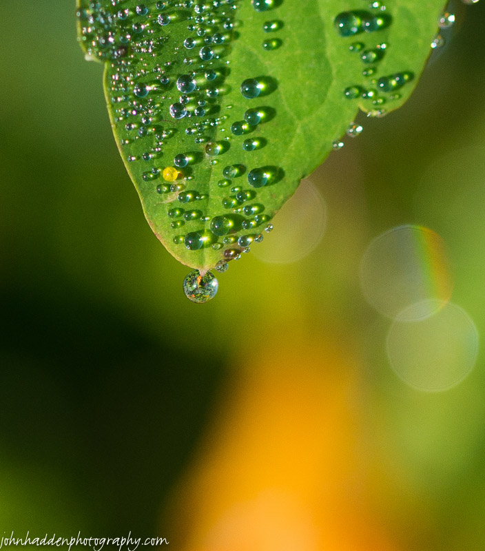
Morning dewdrops cling to jewel weed leaves
Morning Observation:
This morning in Huntington at 6:40AM it’s currently 60 degrees under partly cloudy skies. Winds are calm. Relative humidity is 99%, dewpoint 60, barometric pressure 30.01”. Yesterday’s high was 87, and the overnight low was 60.
Forecast:
Warm, humid weather will persist across the region today. We’ll see mostly sunny skies with a 20% chance of showers and thunderstorms this afternoon as diurnal heating and orographic lift combine with a minor trough to kick off some higher elevation thunderstorms. Highs will be in the mid 80s to near 90 with dewpoints in the mid-to-upper 60s. Winds will be light and variable winds. Tonight should be partly cloudy with a 20% chance of showers and thunderstorms until midnight. Lows will be in the mid 60s with light and variable winds.
Wednesday should be similar—partly sunny with a 20% chance of showers and thunderstorms in the afternoon. Highs will be in the mid 80s with light and variable winds, becoming southerly around 10 mph in the afternoon. Wednesday night should be partly cloudy and muggy with lows in the upper 60s and south winds around 10 mph.
A cold front will approach the region on Thursday. We’ll see partly sunny skies with highs in the lower 80s and south winds 10 to 15 mph gusting up to 25 mph. Thursday night showers and thunderstorms are likely as the cold front moves in. Lows will be in the lower 60s. Chance of rain is 60%.
Almanac:
Last year on this date we had a high of 68 and a low of 47. We picked up 0.07″ of rain.
Burlington norms for this date are highs of 79 and lows of 59.
The record high was 93°F in 2002 (we had a high of 89).
The record low was 40°F in 1918.
Sky Notes:
Sunrise: 5:58 AM EDT
Sunset: 7:52 PM EDT
Length of Visible Light: 14h 56m
Length of Day: 13h 54m
Tomorrow will be 2m46s shorter.
The Moon is a waxing crescent, 3d 20h old with 13% illumination.
Moonrise: 9:49 AM EDT
Moonset: 9:40 PM EDT
About Today’s Photo:
Yesterday morning’s dew clings to jewel weed leaves next to the house.
Nikon D600, Sigma 105mm macro, ISO 640, f/4.5, 1/2000″ exposure
Monday, August 17, 2015

A solidary bee loads up on pollen from our hydrangea
Morning Observation:
This morning in Huntington at 6:50AM it’s currently 61 degrees under mostly clear skies. Winds are calm. Relative humidity is 99%, dewpoint 60, barometric pressure 30.05”. Yesterday’s high was 84, and the overnight low was 60.
Forecast:
A broad dome of high pressure will continue to deliver warm and humid conditions across the region through the middle week. We’ll see mostly sunny skies today with highs in the mid 80s and light and variable winds, becoming southwesterly around 10 mph this afternoon. Tonight should be mostly clear until midnight, then become partly cloudy. Lows will be in the mid 60s with light and variable winds.
Tuesday should be partly sunny with isolated showers and thunderstorms in the afternoon as a trough sneaks through and works with diurnal heating. Highs will be in the mid 80s with light and variable winds. Chance of rain is 20%. Tuesday night should be partly cloudy with lows in the mid 60s and light and variable winds.
Wednesday’s looking partly sunny with highs in the mid 80s and south winds around 10 mph. Wednesday night should be partly cloudy with lows in the upper 60s.
Almanac:
Last year on this date we had a high of 69 and low of 57. We picked up 0.10″ of rain.
Burlington norms for this date are highs of 79 and lows of 59.
The record high was 95°F in 1987.
The record low was 42°F in 1961.
Sky Notes:
Sunrise: 5:57 AM EDT
Sunset: 7:54 PM EDT
Length of Visible Light: 14h 59m
Length of Day: 13h 57m
Tomorrow will be 2m46s shorter.
The Moon is a waxing crescent, 2d 20h old with 7% illumination.
Moonrise: 8:51 AM EDT
Moonset: 9:12 PM EDT
About Today’s Photo:
The hydrangea on our back patio is in full bloom right now and is the focus of a lot of activity. There must be a dozen different kinds of pollinators at work buzzing in the blossoms from tiny flies, to bees, to white-faced hornets (which are really hard to get a picture of!) This solitary bee was more accommodating…
Nikon D600, Sigma 105mm macro, ISO 400, f/13, 1/320″ exposure.
Sunday, August 16, 2015

A loon with a beak-full on Forked Lake
Morning Observation:
This morning in Huntington at 7:05AM it’s currently 62 degrees under mostly clear skies. Winds are calm. Relative humidity is 99%, dewpoint 62, barometric pressure 30.09”. We picked up 0.06” of rain in the past 24hrs. Yesterday’s high was 80, and the overnight low was 57.
Forecast:
A strong ridge high pressure cresting over the region and will dominate our weather into the middle of next week. Expect warm, muggy weather ahead! We’ll see mostly sunny skies today with highs in the mid 80s and light and variable winds. Tonight should be mostly clear with lows in the mid 60s and light and variable winds.
Monday should be mostly sunny with highs in the upper 80s and southwest winds around 10 mph. Monday night should be mostly clear with lows in the upper 60s and southwest winds around 10 mph.
Tuesday’s looking partly sunny with a 40% chance of showers as an upper level trough moves in. It’ll be humid with highs in the mid 80s to 90 with light and variable winds. Tuesday night should be partly cloudy with a 40% chance of showers. Lows will be in the upper 60s.
Almanac:
Last year on this date we had a high of 65 and a low of 53. We picked up 0.10″ of rain.
Burlington norms for this date are highs of 79 and lows of 59.
The record high was 96°F in 1944.
The record low was 43°F in 1923.
Sky Notes:
Sunrise: 5:56 AM EDT
Sunset: 7:55 PM EDT
Length of Visible Light: 15h 02m
Length of Day: 13h 59m
Tomorrow will be 2m44s shorter.
The Moon is a waxing crescent, 1d 20h old with 3% illumination.
Moonrise: 7:53 AM EDT
Moonset: 8:45 PM EDT
About Today’s Photo:
We were paddling on Forked Lake in the Adirondacks and came across a family of loons—two fluffy chicks and two adults—doing what loons do. The chicks stayed close together as the adults hunted nearby. We were able to get quite close and talk with the adults with hoots. Magical! Here’s another shot taken shortly after of adult about to give the fish to one of its chicks:

Saturday, August 15, 2015

Turkey vultures during their wings on fence posts in the Taft’s field
Morning Observation:
This morning in Huntington at 8:15AM it’s currently 69 degrees under mostly cloudy skies. Wind are calm. Relative humidity is 99%, dewpoint 68, barometric pressure 30.07” and rising. We picked up 0.08” of rain in the past 24hrs. Yesterday’s high was 80, and the overnight low was 62.
Forecast:
An upper level trough of low pressure will move across the region today bringing scattered showers and isolated thunderstorms this afternoon. We’ll see partly sunny skies with scattered showers with isolated thunderstorms. Highs will be in the upper 70s with light and variable winds. Chance of rain is 30%. Tonight should be mostly clear with isolated showers until midnight. Lows will be in the lower 60s with light and variable winds. Chance of rain is 20%.
High pressure will ridge in on Sunday ushering in a warmer airmass. This airmass is fairly dry though, so don’t expect too much in the way of humidity. We’ll see mostly sunny skies with highs in the mid 80s to near 90 and light and variable winds. Sunday night should be clear with lows in the mid 60s and light and variable winds.
Monday should be mostly sunny and warm with highs again in the upper 80s to 90 with southwest winds around 10 mph. Monday night should be partly cloudy with lows in the upper 60s.
Almanac:
Last year on this date we had a high of 66 and a low of 49. We picked up 0.03″ of rain.
Burlington norms for this date are highs of 79 and lows of 59.
The record high was 97°F in 1944.
The record low was 45°F in 1907.
Sky Notes:
Sunrise: 5:54 AM EDT
Sunset: 7:57 PM EDT
Length of Visible Light: 15h 05m
Length of Day: 14h 02m
Tomorrow will be 2m42s shorter.
The Moon is a waxing crescent, 21 hours old with 1% illumination.
Moonrise: 6:55 AM EDT
Moonset: 8:17 PM EDT
About Today’s Photo:
I was driving over Taft Hill the other morning after a shower when I came across an unusual sight: there were about a dozen turkey vultures perched on the tops of the fence posts running across the field all with their wings outstretched and drying. I’d never seen anything like this before! Here’s a close up as well:

Friday, August 14, 2015

Water lilies, water, and sky on Forked Lake
Morning Observation:
This morning in Huntington at 7:00AM it’s currently 52 degrees under clear skies. Winds are calm. Relative humidity is 99%, dewpoint 52, barometric pressure 30.07”. We picked up 0.02” of rain in the past 24hrs. Yesterday’s high was 75, and the overnight low was 50.
Forecast:
A weak ridge of high pressure continues to build into the region this morning. We’ll see sunny skies this morning, then partly sunny skies with scattered showers with isolated thunderstorms this afternoon as a trough slides through. Highs will be in the upper 70s with south winds around 10 mph. Chance of rain is 50%. A cold front will slide through tonight bringing mostly cloudy skies with scattered showers with isolated thunderstorms until midnight, then isolated showers after midnight. Lows will be in the mid 60s with southwest winds around 10 mph. Chance of rain is 50%.
Saturday should be mostly cloudy in the morning, then become partly sunny with scattered showers with isolated thunderstorms. Highs will be in the upper 70s with light and variable winds. Chance of rain is 40%. Saturday night should be mostly clear with lows in the lower 60s and light and variable winds.
Sunday’s looking mostly sunny and warmer with highs in the mid 80s and light and variable winds. Sunday night should be clear with lows in the upper 60s.
Almanac:
Last year on this date we had a high of 65 and a low of 55. We picked up 0.74″ of rain.
Burlington norms for this date are highs of 80 and lows of 59.
The record high was 96°F in 1944.
The record low was 47°F in 1923.
Sky Notes:
Sunrise: 5:53 AM EDT
Sunset: 7:58 PM EDT
Length of Visible Light: 15h 08m
Length of Day: 14h 05m
Tomorrow will be 2m43s shorter.
The Moon is new, 29d 9h old with 0% illumination.
Moonrise: 5:56 AM EDT
Moonset: 7:47 PM EDT
About Today’s Photo:
We spent a long day of paddling on Forked Lake in the Adirondacks over the weekend. The west end of the lake where a stream fed in was festooned with water lilies and pads. Large fish jumped as we paddled through.
Sony HX90V, ISO 80, f/3.5, 1/1250″ exposure.
Thursday, August 13, 2015
“God rays” light up the sky on Indian Lake
Morning Observation:
This morning in Huntington at 6:50AM it’s currently 58 degrees under overcast skies. Winds are calm. Relative humidity is 99%, dewpoint 58, barometric pressure 29.96” and rising. We picked up 0.05” of rain in the past 24hrs (we picked up 1.30” on 8/11). Yesterday’s high was 76, and the overnight low was 56.
Forecast:
Surface high pressure will begin to build in today bringing a return of mostly quiet weather with a few possible showers this afternoon as a shortwave trough crosses the region. We’ll see partly sunny skies with a slight chance of showers this afternoon. Highs will be in the lower 70s with light and variable winds. Chance of rain is 20%. Tonight should be clear with lows in the mid 50s and light and variable winds.
Friday should be partly sunny with a slight chance of showers and thunderstorms in the morning, then showers likely with a slight chance of thunderstorms in the afternoon as a weak cold front moves through. Highs will be in the upper 70s with south winds around 10 mph. Chance of rain is 60%. Friday night should be partly cloudy with a 50% chance of showers. Lows will be in the mid 60s with southwest winds around 10 mph.
Saturday’s looking partly sunny with a 50% chance of showers. Highs will be in the upper 70s with west winds around 10 mph. Saturday night should be mostly clear with lows in the lower 60s.
Almanac:
Last year on this date we had a high of 69 and a low of 68.
Burlington norms for this date are highs of 80 and lows of 59.
The record high was 97°F in 1947.
The record low was 43°F in 1930.
Sky Notes:
Sunrise: 5:52 AM EDT
Sunset: 8:00 PM EDT
Length of Visible Light: 15h 11m
Length of Day: 14h 07m
Tomorrow will be 2m40s shorter.
The Moon a waning crescent, 28d 9h old with 1% illumination.
Moonrise: 4:57 AM EDT
Moonset: 7:15 PM EDT
About Today’s Photo:
We just got back from a quick vacation to the Adirondacks. One fine evening after showers had moved through on Monday, we were treated to a fine display of “God Rays” (more accurately crepuscular rays) breaking through the clouds on Indian Lake.
Sony RX100mIII, ISO 125, f/4, 1/60″ exposure.
Saturday, August 8, 2015

A waning gibbous moon in a clear morning sky
Morning Observation:
This morning in Huntington at 8:15AM it’s currently 57 degrees under mostly sunny skies. Winds are calm. Relative humidity is 98%, dewpoint 56, barometric pressure 30.04” and rising. Yesterday’s high was 73, and the overnight low was 45.
Forecast:
High pressure continues to dominate our weather with dry and seasonable weather through the remainder of the weekend. We’ll see partly sunny skies today with highs in the mid 70s and light and variable winds. Tonight should be partly cloudy with lows in the upper 50s and light and variable winds.
Sunday should be partly sunny with highs in the upper 70s and light and variable winds. Sunday night should be partly cloudy with lows in the upper 50s and light and variable winds.
A shortwave trough will approach the region Monday bringing mostly cloudy skies with a 30% chance of showers. Highs will be in the upper 70s with south winds around 10 mph. Monday night showers are likely. Lows will be in the lower 60s. Chance of rain is 70%.
Almanac:
Last year on this date we had a high of 76 and a low of 49. We picked up 0.02″ of rain.
Burlington norms for this date are highs of 80 and lows of 60.
The record high was 97°F in 1949.
The record low was 45°F in 1929.
Sky Notes:
Sunrise: 5:46 AM EDT
Sunset: 8:07 PM EDT
Length of Visible Light: 15h 25m
Length of Day: 14h 20m
Tomorrow will be 2m33s shorter.
The Moon is a waning crescent, 23d 10h old with 34% illumination.
Moonrise: 12:35 AM EDT
Moonset: 3:18 PM EDT
About Today’s Photo:
I was stretching after my morning run the other day when the waning gibbous moon caught my eye. I just had to get a shot of it setting behind the white pines on the west side of our property.
Nikon D600, Sigma 120-400mm lens @ 400mm, ISO 200, f/5.6, 1/1600″ exposure.
Friday, August 7, 2015

Evening primrose catches the morning light in our front field
Morning Observation:
This morning in Huntington at 7:05AM it’s currently 51 degrees under partly cloudy skies. Winds are calm. Relative humidity is 98%, dewpoint 50, barometric pressure 29.98” and rising. Yesterday’s high was 73, and the overnight low was 50.
Forecast:
We’ve got a lovely weekend lining up courtesy of weak surface high pressure that is currently moving into the region. We’ll see partly sunny skies today with highs in the lower 70s and light and variable winds. Tonight should be partly cloudy with lows in the mid 50s and light and variable winds.
Saturday should be partly sunny with highs in the mid 70s and light and variable winds. Saturday night should be partly cloudy with lows in the upper 50s and light and variable winds.
Sunday’s looking partly sunny with highs in the upper 70s and light and variable winds. Sunday night should be partly cloudy with lows in the upper 50s.
Almanac:
Last year on this date we had a high of 72 and a low of 54. We picked up 0.05″ of rain.
Burlington norms for this date are highs of 80 and lows of 60.
The record high was 95°F in 2001 (we had a high of 89).
The record low was 40°F in 1964.
Sky Notes:
Sunrise: 5:45 AM EDT
Sunset: 8:09 PM EDT
Length of Visible Light: 15h 28m
Length of Day: 14h 23m
Tomorrow will be 2m33s shorter.
The Moon is a waning crescent, 22d 9h old with 46% illumination.
No Moon Rise
Moonset: 2:15 PM EDT
About Today’s Photo:
Evening primrose (Oenothera), bedecked with morning dew, catches the first light of day in our front field.
Nikon D600, Sigma 105mm macro, ISO 400, f/13, 1/640″ exposure.
Thursday, August 6, 2015

An orb spider in her dew-bedecked web
Morning Observation:
This morning in Huntington at 8:00AM it’s currently 59 degrees under mostly cloudy skies. Winds are calm. Relative humidity is 99%, dewpoint 59, barometric pressure 29.90”. We picked up 0.02” of rain in the past 24hrs. Yesterday’s high was 75, and the overnight low was 56.
Forecast:
Surface high pressure will continue to build across the region today with mainly dry conditions and cool temperatures. A few sprinkles or light showers will be possible over the mountains this afternoon. We’ll see mostly cloudy skies with highs in the lower 70s and northwest winds around 10 mph. Chance of rain is 20%. Tonight should be partly cloudy until midnight, then becoming mostly cloudy. Lows will be in the mid 50s with northwest winds around 10 mph until midnight, becoming light and variable.
Friday should be partly sunny with highs in the lower 70s and light and variable winds. Friday night should be mostly cloudy with lows in the mid 50s and light and variable winds.
Saturday’s looking partly sunny with highs in the mid 70s and light and variable winds. Saturday night should be partly cloudy with lows in the upper 50s.
Almanac:
Last year on this date we had a high of 74 and a low of 54. We picked up 1.31″ of rain.
Burlington norms for this date are highs of 80 and lows of 60.
The record high was 93°F in 1931.
The record low was 44°F in 1964.
Sky Notes:
Sunrise: 5:44 AM EDT
Sunset: 8:10 PM EDT
Length of Visible Light: 15h 30m
Length of Day: 14h 25m
Tomorrow will be 2m30s shorter.
The Moon is waning gibbous, 20d 10h old with 68% illumination.
Moonrise: 11:54 PM EDT
Moonset: 1:07 PM EDT
About Today’s Photo:
Morning is a great time to go hunting for spider webs. This orb spider had spun her web near our raised beds in the front field. Morning dew clings to the web and sparkles in the early morning sunlight.
Nikon D600, Sigma 105mm macro, ISO 400, f/4.5, 1/2000″ exposure.
Wednesday, August 5, 2015

A porcupine along the trail at Mt. Independence
Morning Observation:
This morning in Huntington at 7:20AM it’s currently 60 degrees under mostly cloudy skies. Winds are calm. Relative humidity is 99%, dewpoint 59, barometric pressure 29.85”. We picked up 0.63” of rain in the past 24hrs. Yesterday’s high was 76, and the overnight low was 55.
Forecast:
Another day with afternoon showers on the schedule… We’ll see mostly cloudy skies with a chance of showers this morning, then partly sunny skies with showers likely and a slight chance of imbedded thunderstorms this afternoon as diurnal heating goes to work on weak instability in the atmosphere. Highs will be in the lower 70s with west winds around 10 mph. Chance of rain is 70%. Tonight should be partly cloudy with a 50% chance of showers until midnight, then cloudy after midnight. Lows will be in the mid 50s with west winds around 10 mph.
Thursday should be cloudy with a 40% chance of showers, mainly in the afternoon. Highs will be in the lower 70s with northwest winds around 10 mph. Thursday night should be partly cloudy with lows in the lower 50s and northwest winds around 10 mph.
Friday’s looking partly sunny with highs in the mid 70s and light and variable winds. Friday night should be partly cloudy with lows in the mid 50s.
Almanac:
Last year on this date we had a high of 82 and a low of 59. We picked up 0.01″ of rain.
Burlington norms for this date are highs of 80 and lows of 60.
The record high was 95°F in 1955.
The record low was 43°F in 1972.
Sky Notes:
Sunrise: 5:43 AM EDT
Sunset: 8:11 PM EDT
Length of Visible Light: 15h 33m
Length of Day: 14h 28m
Tomorrow will be 2m28s shorter.
The Moon is waning gibbous, 20d 10h old with 68% illumination.
Moonrise: 11:16 PM EDT
Moonset: 11:58 AM EDT
About Today’s Photo:
Robin & I visited the Mt. Independence State Historical site in Orwell over the weekend. As we walked the trails (harassed by swarms of deer flies!) we came across this little fellow on the side of the trail. He wasn’t all that shy of us, but then again, he’s got pretty good defenses!
Sony HX90V, ISO 800, f/5.6, 1/125″ exposure.
Tuesday, August 4, 2015

Fresh cut round bales in Orwell, VT
Morning Observation:
This morning in Huntington at 6:50AM it’s currently 59 degrees under mostly cloudy skies. Winds are calm. Relative humidity is 99%, dewpoint 59, barometric pressure 29.79”. We picked up 0.37” of rain when the storms rolled through yesterday afternoon. Yesterday’s high was 82, and the overnight low was 57.
Forecast:
An upper level low will continue to bring unsettled weather to northern New York and upstate Vermont today through Wednesday with scattered showers and thunderstorms. Temperatures will trend cooler than normal through the middle week. We’ll see partly sunny skies with a chance of showers and a slight chance of thunderstorms this morning, then mostly cloudy skies with showers and thunderstorms likely this afternoon as a cold front slides through. Some thunderstorms may produce gusty winds and small hail this afternoon. Highs will be in the mid 70s with light and variable winds, becoming southwesterly around 10 mph this afternoon. Chance of rain is 60%. Tonight should be mostly cloudy with a 50% chance of showers and thunderstorms until midnight, then a chance of showers after midnight. Lows will be in the upper 50s with southwest winds around 10 mph until midnight, becoming light and variable.
Wednesday should be partly sunny with a chance of showers in the morning, then mostly cloudy with a chance of showers and thunderstorms in the afternoon. Some thunderstorms may produce gusty winds and small hail in the afternoon. Highs will be in the lower 70s with southwest winds around 10 mph, becoming northwesterly in the afternoon. Chance of rain is 50%. Wednesday night should be partly cloudy with a 50% chance of showers. Lows will be in the mid 50s with northwest winds around 10 mph.
High pressure will build in Thursday brining partly sunny skies with highs around 70 and northwest winds around 10 mph. Thursday night should be partly cloudy with lows in the mid 50s.
Almanac:
Last year on this date we had a high of 81 and a low of 60. We picked up 0.19″ of rain.
Burlington norms for this date are highs of 80 and lows of 60.
The record high was 95°F in 1944.
The record low was 44°F in 1914.
Sky Notes:
Sunrise: 5:42 AM EDT
Sunset: 8:13 PM EDT
Length of Visible Light: 15h 36m
Length of Day: 14h 30m
Tomorrow will be 2m28s shorter.
The Moon is waning gibbous, 19d 9h old with 79% illumination.
Moonrise: 10:41 PM EDT
Moonset: 10:46 AM EDT
About Today’s Photo:
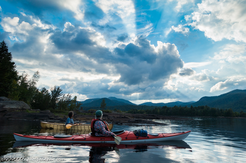
On our way back from kayaking on Lake Champlain on Sunday, we drove through this hayfield in Orwell. The fresh-cut round bales dotted the field out to the horizon line of the Green Mountains.
Sony RX100 III, ISO 125, f/11, 1/200″ exposure.
