Wednesday, April 30, 2014

Silty water in Fargo Brook
Morning Observation:
This morning in Huntington at 6:00AM it’s currently 40 degrees under overcast skies. Winds are out of the east at 7-10 mph. Relative humidity is 81%, dewpoint 34, barometric pressure 30.41”. We picked up 0.08” of rain overnight. Yesterday’s high was 58, and the overnight low was 39.
Forecast:
A large area of low pressure over the central Great Lakes region will move slowly northeast through Thursday bringing rain to the region. The heaviest rain will occur tonight before tapering to showers early Thursday morning. We’ll see cloudy skies this morning with showers during the afternoon. Highs will be around 47F with southeast winds at 10 to 20 mph. Chance of rain is 70%. Tonight will bring more persistent rain. Lows will be near 40F with winds from the southeast at 10 to 20 mph. Total rainfall should be around a half an inch.
Thursday should bring steady light rain in the morning with showers continuing into the afternoon. High will be around 66F with winds out of the south at 10 to 15 mph. Chance of rain is 80%. Thursday night should bring light rain early with decreasing clouds late. Lows will be around 42F with west-southwest winds at 5 to 10 mph. Chance of rain is 60%.
Friday’s looking partly cloudy during the morning hours, giving way to occasional showers in the afternoon as an upper level low approaches. High will be around 57F with winds out of the west-southwest at 10 to 20 mph. Chance of rain is 50%. Friday night should be partly cloudy with low near 40F and southwest winds at 5 to 10 mph.
Almanac:
Last year on this date we had a high of 70 and a low of 47.
Burlington norms for this date are highs of 62 and a low of 40.
Record High was 84°F in 2004 (we had a high of 82).
Record Low was 27°F in 1967.
Sky Notes:
Sunrise: 5:44 AM EDT
Sunset: 7:54 PM EDT
Length of Visible Light: 15h 13m
Length of Day: 14h 10m
Tomorrow will be 2m 39s longer.
The Moon is a waxing crescent, 1d 4h old with 2% illumination.
Moonrise: 6:42 AM EDT
Moonset: 9:32 PM EDT
About Today’s Photo:
Fine silts tend to be in the water of Fargo Brook this time of year.
Tuesday, April 29, 2014

Bleached beech leaves still clinging
Morning Observation:
This morning in Huntington at 6:45AM it’s currently 44 degrees under partly cloudy skies. Winds are calm. Relative humidity is 82%, dewpoint 38, barometric pressure 30.29” and rising rapidly. Yesterday’s high was 53, and the overnight low was 41.
Forecast:
High pressure will bring dry weather through most of today. A large area of low pressure currently across the central United States will gradually shift eastward bringing increasingly breezy conditions today followed by periods of rain over the next few days. We’ll see partly sunny skies today with highs in the upper 50s and southeast winds 15 to 20 mph gusting up to 30 mph. Tonight should be cloudy with a chance of rain mainly after midnight. Lows will be in the upper 30s with southeast winds 15 to 20 mph. Chance of rain is 50%.
Rain will move into the region Wednesday with highs in the upper 40s and southeast winds 15 to 20 mph gusting up to 30 mph. Chance of rain is 90%. Rain will continue into Wednesday night with rain heavy at times. Lows will be in the lower 40s with southeast winds 15 to 20 mph gusting up to 30 mph. Chance of rain is 90%.
Rain will continue into Thursday. Highs will be in the upper 50s with south winds around 10 mph. Chance of rain is 90%. Thursday night should be partly cloudy with a 50% chance of showers. Lows will be in the lower 40s.
Almanac:
Last year on this date we had a high of 65 and a low of 42.
Burlington norms for this date are highs of 61 and lows of 40.
Record High was 85°F in 1986.
Record Low was 24°F in 1934.
Sky Notes:
Sunrise: 5:45 AM EDT
Sunset: 7:53 PM EDT
Length of Visible Light: 15h 11m
Length of Day: 14h 07m
Tomorrow will be 2m 41s longer.
The Moon is new, 4 hours old with 0% illumination.
Moonrise: 6:02 AM EDT
Moonset: 8:31 PM EDT
About Today’s Photo:
The last of last summer’s beech leaves still cling dried and bleached to some of the smaller saplings in the woods.
Sony RX100 II, ISO 160, f/1.8, 1/2000″ exposure
Monday, April 28, 2014

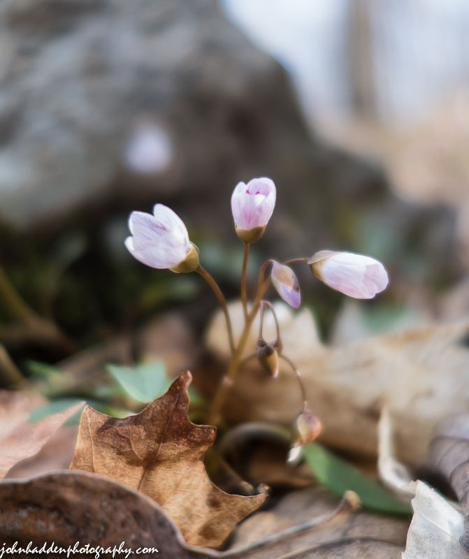
Hepatica just starting to bloom in the woods behind the house
Morning Observation:
This morning in Huntington at 5:45AM it’s currently 36 degrees under mostly clear skies. Winds are calm. Relative humidity is 98%, dewpoint 36, barometric pressure 30.09” and falling. We picked up 0.09” of rain in the past 24hrs. Yesterday’s high was 44, and the overnight low was 36.
Forecast:
High pressure has ridge over the area overnight and is departing to our east this morning. This morning’s clear skies should give way to clouds later in the day. It will be warmer with highs will be in the mid 50s and north winds 10 to 15 mph. Tonight should be mostly cloudy with lows in the upper 30s and northeast winds 10 to 15 mph, becoming southeast after midnight.
Tuesday should be partly sunny and breezy with highs in the upper 50s and southeast winds 15 to 25 mph. Low pressure will approach the region Tuesday night bringing cloudy skies and a 30% chance of rain showers. It’ll be breezy with lows in the mid 30s and southeast winds 20 to 25 mph.
Wednesday’s looking cloudy with a 40% chance of rain showers. Highs will be in the lower 50s with southeast winds 15 to 20 mph. Wednesday night will be showery with lows in the upper 30s. Chance of rain is 80%.
Almanac:
Last year on this date we had a high of 71 and a low of 31.
Burlington norms for this date are highs of 61 and a low of 40.
Record High was 90°F in 1990.
Record Low was 24°F in 1947.
Sky Notes:
Sunrise: 5:47 AM EDT
Sunset: 7:52 PM EDT
Length of Visible Light: 15h 08m
Length of Day: 14h 04m
Tomorrow will be 2m 43s longer.
The Moon is a waning crescent, 28d 15h old with 1% illumination.
Moonrise: 5:26 AM EDT
Moonset: 7:26 PM EDT
About Today’s Photo:
Another lovely spring ephemeral, hepatica, is just starting to bloom in the woods up behind the house. These blossoms were just unfurling on a chilly morning.
Sony RX100 II, ISO 160, f/2, 1/500″ exposure.
Sunday, April 27, 2014

The beaver pond along the Mailbox Trail
Morning Observation:
This morning in Huntington at 7:40AM it’s currently 34 degrees and “snizzling” under overcast skies. Winds are calm. Relative humidity is 98%, dewpoint 34, barometric pressure 29.95” and rising rapidly. We picked up 0.38” of rain in the past 24hrs. Yesterday’s high was 55, and the overnight low was 34.
Forecast:
Cool and raw conditions will be with us through the day today. We’ll see cloudy skies with rain showers or snow likely this morning, then a chance of rain showers this afternoon. Expect little or no snow accumulation. Highs will be in the upper 40s with northwest winds 10 to 15 mph. Chance of precipitation is 70%. Tonight should be mostly cloudy with a slight chance of rain showers until midnight. Lows will be in the mid 30s with north winds 10 to 15 mph until midnight, becoming light and variable. Chance of rain is 20%.
High pressure currently over Hudson Bay will deliver drier but cool conditions Monday. We’ll see mostly cloudy skies with highs in the mid 50s and orth winds 10 to 15 mph. Monday night should be mostly cloudy with lows in the upper 30s and easterly winds around 10 mph.
Tuesday should be mostly cloudy with highs in the upper 50s and southeast winds 15 to 20 mph gusting up to 30 mph. Low pressure will move into the region Tuesday night brining cloudy skies and a 40% chance of showers. Lows will be in the upper 30s.
Almanac:
Last year on this date we had a high of 61 and a low of 28. We picked up 0.12″ of rain.
Burlington norms for this date are highs of 60 and low of 39.
Record High was 90 °F in 1990.
Record Low was 22°F in 1972.
Sky Notes:
Sunrise: 5:48 AM EDT
Sunset: 7:51 PM EDT
Length of Visible Light: 15h 05m
Length of Day: 14h 02m
Tomorrow will be 2m 44s longer.
The Moon is a waning crescent, 27d 17h old with 4% illumination.
Moonrise: 4:52 AM EDT
Moonset: 6:18 PM EDT
About Today’s Photo:
The beaver pond along the Mailbox Trail is once again inhabited and filling up. The large dam on the left side of the photo blew out during Irene’s flooding, sending a wall of water downstream that took out a neighbor’s driveway and inundating a pasture. But the beavers moved back in and have renovated the dam and lodge. It’s a lovely place to hang out!
Saturday, April 26, 2014
Spring beauties blooming in the woods!
Morning Observation:
This morning in Huntington at 8:10AM it’s currently 43 degrees and raining lightly under overcast skies. Winds are calm. Relative humidity is 93%, dewpoint 41, barometric pressure 29.70”. We picked up 0.11” of rain overnight. Yesterday’s high was 57, and the overnight low was 41.
Forecast:
A northerly surface low will produce rain showers this morning and lingering showers through the day. Highs will be around 50 with south winds around 10 mph gusting up to 25 mph. Chance of rain is 80%. Rain showers will continue into tonight. Lows will be in the upper 30s with west winds around 10 mph until midnight, becoming light and variable. Chance of rain is 60%.
Sunday should be cloudy with a 50% chance of rain showers. Highs will be in the upper 40s with north winds 10 to 15 mph. Sunday night should be partly cloudy with lows in the mid 30s and north winds 10 to 15 mph.
High pressure will ridge in on Monday bringing partly sunny skies with highs in the lower 50s and north winds 10 to 15 mph. Monday night should be mostly cloudy with lows in the upper 30s.
Almanac:
Last year on this date we had a high of 53 and a low of 29.
Burlington norms for this date are highs of 60 and lows of 39.
Record High was 84°F in 1913.
Record Low was 20°F in 1919.
Sky Notes:
Sunrise: 5:50 AM EDT
Sunset: 7:49 PM EDT
Length of Visible Light: 15h 02m
Length of Day: 13h 59m
Tomorrow will be 2m 45s longer.
The Moon is a waning crescent, 26d 17h old with 9% illumination.
Moonrise: 4:19 AM EDT
Moonset: 5:09 PM EDT
About Today’s Photo:
The trail up behind our house that I run just about every morning is a great place to see the emergence of spring ephemeral flowers. Just yesterday I noted hepatica and these spring beauties. Certain places along the trail will soon be carpeted with them!
Friday, April 25, 2014

Pussy willows popping in the front field
Morning Observation:
This morning in Huntington at 7:10AM it’s currently a brisk 27 degrees under clear skies. Winds are calm. Relative humidity is 95%, dewpoint 26, barometric pressure 30.04″ and rising. Yesterday’s high was 51, and the overnight low was 25.
Forecast:
High pressure cresting over the region this morning will slide east during the day as clouds build in ahead of low pressure. We’ll see partly sunny skies during the day with highs in the upper 50s and light and variable winds, becoming northerly around 10 mph this afternoon. Tonight should be cloudy with showers likely mainly after midnight. Lows will be in the upper 30s with light and variable winds becoming southeasterly around 10 mph after midnight. Chance of rain is 70%.
Saturday showers are likely. Highs will be in the upper 40s with south winds 10 to 15 mph. Chance of rain is 70%. Showers will continue into Saturday night. Lows will be in the mid 30s with light and variable winds. Chance of rain is 70%.
Showers will linger into Sunday with cloudy skies and a 50% chance of rain showers. Highs will be in the upper 40s with north winds 10 to 15 mph gusting up to 25 mph. Sunday night should be partly cloudy with lows in the mid 30s.
Almanac:
Last year on this date we had a high of 62 and a low of 30. We picked up 0.18″ of rain.
Burlington norms for this date are highs of 60 and lows of 38.
Record High was 86°F in 2009 (we had a high of 86).
Record Low was 20°F in 1919.
Sky Notes:
Sunrise: 5:52 AM EDT
Sunset: 7:48 PM EDT
Length of Visible Light: 14h 59m
Length of Day: 13h 56m
Tomorrow will be 2m 46s longer.
The Moon is a waning crescent, 25d 16h old with 17% illumination.
Moonrise: 3:47 AM EDT
Moonset: 3:59 PM EDT
About Today’s Photo:
The pussy willows that were just peeking out a week ago are popping now!
Nikon D600, Sigma 105mm lens, ISO 800, f/8, 1/400″ exposure.
Thursday, April 24, 2014

Garlic sprouting in our raised beds!
Morning Observation:
This morning in Huntington at 7:20AM it’s currently a cool 34 degrees under mostly cloudy skies. Winds are out of the northwest at 2-5 mph. Relative humidity is 65%, dewpoint 23, barometric pressure 29.84″ and rising. We picked up 0.03″ of rain in the past 24hrs. Yesterday’s high was 49, and the overnight low was 33.
Forecast:
High pressure will build into the region today bringing clearing skies and gusty winds. We’ll see partly sunny skies with highs around 50 and northwest winds 20 to 25 mph gusting up to 35 mph. Tonight should be mostly clear with lows in the upper 20s and northwest winds 15 to 20 mph gusting up to 30 mph and diminishing to around 10 mph after midnight.
Friday should be partly sunny and milder with highs in the upper 50s and light and variable winds. A surface low will move into the region Friday night bringing cloudy skies with a 50% chance of rain showers. Lows will be in the mid 30s with southeast winds around 10 mph.
Saturday rain showers are likely. Highs will be in the mid 50s with south winds around 10 mph. Chance of rain is 60%. Saturday night should be cloudy with a 50% chance of showers. Lows will be in the mid 30s.
Almanac:
Last year on this date we had a high of 74 and a low of 30. We picked up 0.03″ of rain.
Burlington norms for this date are highs of 59 and low of 38.
Record High was 80°F in 2001.
Record Low was 23°F in 1930.
Sky Notes:
Sunrise: 5:53 AM EDT
Sunset: 7:47 PM EDT
Length of Visible Light: 14h 56m
Length of Day: 13h 53m
Tomorrow will be 2m 48s longer.
The Moon is a waning crescent, 24d 16h old with 26% illumination.
Moonrise: 3:14 AM EDT
Moonset: 2:49 PM EDT
About Today’s Photo:
The garlic Robin planted last fall is popping up! I see scapes in our future!
Wednesday, April 23, 2014

Bloodroot in bloom down by Fargo Brook
Morning Observation:
This morning in Huntington at 6:40AM it’s currently 41 degrees and drizzling under overcast skies. Winds are calm. Relative humidity is 96%, dewpoint 40, barometric pressure 29.52” and rising. We picked up 0.19” of rain in the past 24hrs. Yesterday’s high was 66, and the overnight low was 41.
Forecast:
Low pressure will continue to affect the region through tonight, producing cloudy skies and isolated to scattered
showers. We’ll see showers today with highs only in the upper 40s with northwest winds 10 to 15 mph. Chance of rain is 60%. Tonight should be cloudy until midnight, then become partly cloudy as high pressure builds in to the region. There’s a chance of rain showers and a slight chance of snow showers after midnight. Lows will be around 30 with northwest winds 15 to 20 mph. Chance of precipitation is 50%.
Thursday should be partly sunny with a chance of snow showers in the morning. It’ll be breezy with highs around 50 and northwest winds 15 to 25 mph gusting up to 35 mph. Chance of snow is 40%. Thursday night should be clear and chilly with lows in the upper 20s and north winds 15 to 20 mph.
Friday’s looking partly sunny with highs in the upper 50s and light and variable winds. Low pressure will move into the region Friday night bringing showers likely. Lows will be around 40. Chance of rain is 60%. Showers should continue into the weekend.
Almanac:
Last year on this date we had a high of 54 and a low of 27.
Burlington norms for this date are highs of 59 and a low of 38.
Record High was 85°F in 1885.
Record Low was 23°F in 1930.
Sky Notes:
Sunrise: 5:55 AM EDT
Sunset: 7:46 PM EDT
Length of Visible Light: 14h 53m
Length of Day: 13h 51m
Tomorrow will be 2m 49s longer.
The Moon is a waning crescent, 23d 16h old with 37% illumination.
Moonrise: 2:39 AM EDT
Moonset: 1:38 PM EDT
About Today’s Photo:
Bloodroot is one of the earliest spring ephemeral flowers. It has an interesting cold weather defense mechanism where the bloom can tuck back into its leathery leaves overnight to protect it from frost. This pair was enjoying yesterday’s warmth.
Nikon D600, Sigma 105mm lens, ISO 800, f/10, 1/320″ exposure.
Tuesday, April 22, 2014

Coltsfoot blooming!
Morning Observation:
This morning in Huntington at 7:10AM it’s currently 50 degrees under mostly cloudy skies. Winds are out of the south at 3-5 mph. Relative humidity is 55%, dewpoint 35, barometric pressure 29.60″ and falling. Yesterday’s high was 71, and the overnight low was 45.
Forecast:
A cold front and associated low pressure currently over the eastern Great Lakes will move through the north region later today bringing showers and possibly a thunderstorm. Temperatures will turn noticeably cooler with
highs in the 60s today falling into to the 40s and 50s on Wednesday. We’ll see cloudy skies chance of showers this morning, then occasional showers with a slight chance of thunderstorms this afternoon. Highs will be in the mid 60s with south winds around 10 mph. Chance of rain is 80%. Tonight will be cloudy with showers likely and a slight chance of thunderstorms until midnight, then a chance of showers after midnight. Lows will be around 40 with light and variable winds, becoming northwesterly around 10 mph after midnight. Chance of rain is 70%.
Wednesday should be cloudy with a 50% chance of showers. Highs will be in the upper 40s with northwest winds 15 to 20 mph. Wednesday night should be partly cloudy with a chance of rain showers. Lows will be around 30 with northwest winds 15 to 20 mph gusting to 30 mph. Chance of rain is 50%.
High pressure will move in for Thursday bringing sunny skies and with highs in the lower 50s and northwest winds 20 to 25 mph gusting up to 40 mph. Thursday night should be mostly clear with lows in the lower 30s.
Almanac:
Last year on this date we had a high of 57 and a low of 23.
Burlington norms for this date are highs of 58 and lows of 37
Record High was 80°F in 1973.
Record Low was 21°F in 1947.
Sky Notes:
Sunrise: 5:56 AM EDT
Sunset: 7:45 PM EDT
Length of Visible Light: 14h 50m
Length of Day: 13h 48m
Tomorrow will be 2m 49s longer.
The Moon is in its last quarter, 22d 16h old with 49% illumination.
Moonrise: 1:59 AM EDT
Moonset: 12:28 PM EDT
About Today’s Photo:
I was down in New Haven yesterday and came across a bloom of coltsfoot on the edge of a gravel parking lot. This hardy and early blooming flower likes disturbed soils and you’ll often find it along our dirt road. I haven’t seen it up in our neck of the woods yet, but I’m sure it’ll be blooming soon!
Sony RX100 II, ISO 160, f/6.3, 1/800″ exposure.
Monday, April 21, 2014

A dried weed and frosted Hump
Morning Observation:
This morning in Huntington at 6:40AM it’s currently 52 degrees under overcast skies. Winds are out of the south at 2-4 mph. Relative humidity is 42%, dewpoint 29, barometric pressure 30.09” and falling. Yesterday’s high was 60, and the overnight low was 45.
Forecast:
Departing high pressure should deliver a partly sunny day today with highs in the upper 60s and southwest winds around 10 mph. Tonight should be mostly cloudy with a slight chance of showers after midnight as a cold front and associated low pressure approach the region. Lows will be in the lower 40s with south winds around 10 mph until midnight, becoming light and variable. Chance of rain is 20%.
Tuesday will bring showers. Highs will be in the mid 60s to near 70 with south winds 10 to 15 mph gusting up to 30 mph. Chance of rain is 80%. Showers will continue into Tuesday night with lows in the upper 30s and west winds around 10 mph. Chance of rain is 80%.
Wednesday’s looking mostly cloudy with a 50% chance of rain showers. Highs will be in the upper 40s with northwest winds 15 to 20 mph gusting to 30 mph. Wednesday night should be partly cloudy with a 30% chance of rain showers. Lows will be around 30.
Almanac:
Last year on this date we had a high of 45 and a low of 24.
Burlington norms for this date are highs of 58 and low of 37.
Record High was 83°F in 1977.
Record Low was 18°F in 1908.
Sky Notes:
Sunrise: 5:58 AM EDT
Sunset: 7:43 PM EDT
Length of Visible Light: 14h 47m
Length of Day: 13h 45m
Tomorrow will be 2m 51s longer.
The Moon is waning gibbous, 21d 16h old with 60% illumination.
Moonrise: 1:14 AM EDT
Moonset: 11:18 AM EDT
About Today’s Photo:
An artsy shot from our front field with a still-frosty Camel’s Hump summit in the background.
Nikon D600, Sigma 105mm lens, ISO 125, f/11, 1/160″ exposure.
Sunday, April 20, 2014

Otter Creek pours over the falls at Vergennes yesterday.
Morning Observation:
This morning in Huntington at 7:50AM it’s currently 31 degrees under clear skies. Winds are calm. Relative humidity is 97%, dewpoint 30, barometric pressure 30.51” and rising. We picked up a total of 0.16” of rain yesterday before the sun came out. Yesterday’s high was 49, and the overnight low was 23.
Forecast:
Surface high pressure over the region this morning will slide eastward today, and warm air advection will provide region with a warmer day today and into Monday. We’ll see sunny skies this morning, then partly sunny skies later in the day. Highs will be in the upper 50s with light and variable winds, becoming southerly around 10 mph this afternoon. Tonight should be partly cloudy until midnight, then become mostly cloudy. Lows will be in the mid 30s with south winds 10 to 15 mph.
Monday should be partly sunny and warmer with highs in the upper 60s and southwest winds 10 to 15 mph. Low pressure and an associated cold front will approach the region Monday night bringing cloudy skies with a 30% chance of showers. Lows will be in the mid 40s with south winds around 10 mph.
Tuesday showers are likely. Highs will be in the mid 60s with south winds around 10 mph. Chance of rain is 70%. Rain will continue into Tuesday night with lows around 40. Chance of rain is 60%.
Almanac:
Last year on this date we had a high of 50 and a low of 33. We picked up 0.03″ of rain.
Burlington norms for this date are highs of 57 and a low of 37.
Record High was 86°F in 1941.
Record Low was 16°F in 1897.
Sky Notes:
Sunrise: 6:00 AM EDT
Sunset: 7:42 PM EDT
Length of Visible Light: 14h 44m
Length of Day: 13h 42m
Tomorrow will be 2m 51s longer.
The Moon is waning gibbous, 20d 17h old with 71% illumination.
Moonrise: 12:24 AM EDT
Moonset: 10:13 AM EDT
About Today’s Photo:
Otter Creek and Lake Champlain are at or above flood stage right now. The falls in Vergennes were roaring yesterday at mid day when we visited the inundated little park down along the banks.
Nikon D600, Nikon 24-120mm lens @ 31mm, ISO 800, f/10, 1/1250″ exposure
Saturday, April 19, 2014

A slate-colored junco perches in the hemlock near the feeder.
Morning Observation:
This morning in Huntington at 8:45AM it’s currently 39 degrees and raining under overcast skies. Winds are calm. Relative humidity is 95%, dewpoint 38, barometric pressure 30.24” and rising rapidly. We’ve picked up 0.10” or rain this morning. We are snow-free once again. Yesterday’s high was 53, and the overnight low was 37.
Forecast:
Surface high pressure will build into the region today. We’ll see cloudy skies with a chance of rain this morning, giving way to partly sunny skies this afternoon. Highs will be in the mid 40s with northwest winds 10 to 15 mph. Chance of rain is 50%. Tonight should be clear and cool with lows in the mid 20s and northwest winds 10 to 15 mph until midnight, becoming light and variable.
Sunday should be sunny in the morning, then become partly cloudy. Highs will be in the mid 50s with light and variable winds, becoming southerly around 10 mph in the afternoon. Sunday night should be partly cloudy with lows in the upper 30s ands south winds 10 to 15 mph.
Monday’s looking partly sunny with highs in the lower 60s and southwest winds 10 to 15 mph. Monday night should be mostly cloudy with a 30% chance of showers as a surface low approaches the region. Lows will be in the mid 40s.
Almanac:
Last year on this date we had a high of 75 and a low of 46. We picked up 0.90″ of rain.
Burlington norms for this date are highs of 57 and lows of 36.
Record High was 91°F in 1976.
Record Low was 22°F in 1918.
Sky Notes:
Sunrise: 6:01 AM EDT
Sunset: 7:41 PM EDT
Length of Visible Light: 14h 40m
Length of Day: 13h 39m
Tomorrow will be 2m 53s longer.
The Moon is waning gibbous, 19d 18h old with 80% illumination.
No Moon Rise
Moonset: 9:12 AM EDT
About Today’s Photo:
The drab coloring of the slate-colored junco often causes us to overlook it. But up close, he’s quite a handsome fellow, dressed up in his understated tuxedo…
Nikon D600, Sigma 120-400mm lens @ 400mm, ISO 800, f/5.6, 1/1600″ exposure.
Friday, April 18, 2014

Icicles hang from the spruce along our driveway
Morning Observation:
This morning in Huntington at 6:45AM it’s currently 27 degrees under mostly clear skies. Winds are calm. Relative humidity is 88%, dewpoint 24, barometric pressure 30.48” and falling rapidly. We have just a bit of snow here and there. Yesterday’s high was 47, and the overnight low was 26.
Forecast:
Departing high pressure will continue to provide generally dry conditions to the region today with temperatures returning to seasonal norms to end the work week. A weak upper trough and surface cold front will bring a few rain and snow showers to the area tonight into Saturday morning. This morning’s partly cloudy skies will give way to mostly cloudy skies later today. Highs will be around 50 with south winds 10 to 15 mph. Tonight should be cloudy with a chance of rain showers and a chance of snow showers after midnight. Lows will be in the mid 30s with south winds around 10 mph. Chance of precipitation is 50%.
Saturday should be mostly cloudy with a chance of rain or snow showers in the morning, then become partly sunny in the afternoon as high pressure builds back in. Highs will be in the upper 40s with northwest winds 10 to 15 mph gusting up to 25 mph. Chance of precipitation is 40%. Saturday night should be clear with lows in the upper 20s and northwest winds 10 to 15 mph gusting up to 25 mph.
Sunday looking mostly sunny with highs in the mid 50s and southwest winds around 10 mph. Sunday night should be partly cloudy with lows in the upper 30s.
Almanac:
Last year on this date we had a high of 62 and a low of 29.
Burlington norms for this date are highs of 56 and lows of 36.
Record High was 91°F in 1976.
Record Low was 21°F in 1948.
Sky Notes:
Sunrise: 6:03 AM EDT
Sunset: 7:40 PM EDT
Length of Visible Light: 14h 37m
Length of Day: 13h 36m
Tomorrow will be 2m 53s longer.
The Moon is waning gibbous, 18d 16h old with 89% illumination.
Moonrise: 11:27 PM EDT
Moonset: 8:18 AM EDT
About Today’s Photo:
The strong April sun went to work quickly on the snow that fell the other day. I noticed these long icicles hanging from a spruce next to our driveway. I like the way the icicles aren’t hanging straight down because the boughs rise up as the snow load decreases.
Thursday, April 17, 2014

A white throated sparrow in the hemlock by the feeder yesterday
Morning Observation:
This morning in Huntington at 7:30AM it’s currently 20 degrees under clear skies. Winds are calm. Relative humidity is 95%, dewpoint 19, barometric pressure 30.75” and rising. We have about 2.5” of snow left on the ground. Yesterday’s high was 32, and the overnight low was 15.
Forecast:
A large area of high pressure exists over northern New England this morning and will be slowly moving northeast through Friday. We’ll see sunshine today and a gradual warming trend with highs returning to seasonal normals by
Friday. Today will be mostly sunny with highs in the upper 40s and light and variable winds, becoming southerly around 10 mph this afternoon. Tonight should be mostly clear with lows in the mid 20s and south winds around 10 mph until midnight, becoming light and variable.
Friday should be partly sunny with highs in the lower 50s and south winds 10 to 15 mph. An upper level trough will approach the region Friday night bringing mostly cloudy skies with a chance of rain or snow showers. Lows will be in the mid 30s with south winds around 10 mph. Chance of precipitation is 40%.
Saturday’s looking mostly cloudy with a 40% chance of showers. Highs will be in the upper 40s with northwest winds 15 to 20 mph. Saturday night should be partly cloudy with lows in the lower 30s.
Almanac:
Last year on this date we had a high of 54 and a low of 30. We picked up 0.21″ of rain.
Burlington norms for this date are highs of 56 and a lows of 36.
Record High was 90°F in 2002 (we had a high of 89).
Record Low was 13°F in 1971.
Sky Notes:
Sunrise: 6:05 AM EDT
Sunset: 7:38 PM EDT
Length of Visible Light: 14h 34m
Length of Day: 13h 33m
Tomorrow will be 2m 54s longer.
The Moon is waning gibbous, 17d 16h old with 95% illumination.
Moonrise: 10:26 PM EDT
Moonset: 7:30 AM EDT
About Today’s Photo:
As I type this, I can hear the white throated sparrow singing his reedy song out in the hemlock by the studio stairs. Another spring harbinger, the white throat is a favorite of mine. I love the yellow eyebrows…
Nikon D600, Sigma 120-400mm lens @ 400mm, ISO 800, f/7.1, 1/1600″ exposure.
Wednesday, April 16, 2014

A tree swallow in the rain
Morning Observation:
Well, April Fools Day may have been two weeks ago, but it sure feels like Mother Nature’s playing a joke on us this morning…
This morning in Huntington at 6:25AM it’s currently 19 degrees under partly cloudy skies. Winds are calm. Relative humidity is 87%, dewpoint 16, barometric pressure 30.12” and rising rapidly. We picked up 1.40” of rain and 5.25” of snow. Yesterday’s high was 64, and the overnight low was 19.
Forecast:
High pressure is currently building into the region and will dominate the weather through the end of the week. We’ll see partly sunny skies today with highs only in the mid 30s and northwest winds 15 to 20 mph gusting up to 30 mph. Tonight should be clear and cold with lows around 15 and northeast winds around 10 mph until midnight, becoming light and variable.
Thursday should be sunny and a bit warmer with highs in the upper 40s and southeast winds 10 to 15 mph. Thursday Night should be mostly clear with lows in the mid 20s and south winds 10 to 15 mph.
Friday’s looking mostly sunny and seasonable with highs in the mid 50s and south winds around 10 mph. An upper level trough will move into the region Friday night bringing partly cloudy with a chance of rain or snow showers. Lows will be in the mid 30s. Chance of precipitation is 30%.
Almanac:
Last year on this date we had a high of 58 and a low of 40.
Burlington norms for this date are highs of 55 and lows of 35.
Record High was 86°F in 2002 (we had a high of 85).
Record Low was 18°F in 1908.
Sky Notes:
Sunrise: 6:06 AM EDT
Sunset: 7:37 PM EDT
Length of Visible Light: 14h 31m
Length of Day: 13h 30m
Tomorrow will be 2m 55s longer.
The Moon is waning gibbous, 16d 15h old with 99% illumination.
Moonrise: 9:21 PM EDT
Moonset: 6:49 AM EDT
About Today’s Photo:
Yesterday’s rain came down in sheets at times, particularly in the afternoon, before transitioning to sleet and snow at dusk. This tree swallow was hunkering down on a nesting box along Shaker Mountain Road. I’m not sure if the rain was bothering him much…
Nikon D600, Sigma 120-400mm lens @ 400mm, ISO 400, f/7.1, 1/125″ exposure.
Tuesday, April 15, 2014

Late afternoon light warms the bark of this birch in our front field
Morning Observation:
This morning in Huntington at 7:05AM it’s currently 60 degrees and raining lightly under overcast skies. Winds are out of the west at 2-5 mph. Relative humidity is 86%, dewpoint 56, barometric pressure 29.56” and falling. We picked up 0.05” of rain overnight. Yesterday’s high was 80, and the overnight low was 55.
There is a Flood Warning in effect for the Winooski River and a Flood Watch in effect for the rest of our region until through Wednesday evening.
Forecast:
Active weather is on tap for the region over the next 48 hours as a strong cold front moves from west to east across the area. Rain will become widespread and steady over the area and, combined with additional snowmelt, will make for more flooding in river valleys. We’ll also see strong southerly winds gusting to as high as 50 miles per hour across the Champlain Valley ahead of the front. Temperatures will fall sharply as the front passes and precipitation will turn to snow with some minor snow accumulations possible overnight. We’ll see rain, heavy at times in the afternoon. Highs will be in the lower 60s with temperature falling into the lower 40s by this afternoon. Winds will be out of the south at 10 to 15 mph with gusts up to 45 mph. Chance of rain is near 100%. Tonight we’ll see snow or rain until midnight, then occasional snow showers after midnight. We could see snow accumulations of 1 to 3 inches with up to 4 inches at higher elevations. Lows will be around 20 with northwest winds 10 to 15 mph gusting up to 30 mph. Chance of precipitation is near 100%.
High pressure will build in Wednesday bringing mostly sunny skies with some scattered snow showers in the morning. Highs will only make into the mid 30s with northwest winds 15 to 20 mph gusting up to 35 mph. Chance of snow is 30%. Wednesday night should be clear and chilly with lows around 20 and northeast winds around 10 mph.
Thursday’s looking mostly sunny and seasonable with highs around 50 and southeast winds around 10 mph. Thursday night should be mostly clear with lows in the upper 20s. Temperatures will continue their upward trend into the weekend.
Almanac:
Last year on this date we had a high of 62 and a low of 24. We picked up 0.04″ of rain.
Burlington norms for this date are highs of 55 and lows of 35.
Record high was 82°F in 2003.
Record low was 18°F in 1926.
Sky Notes:
Sunrise: 6:08 AM EDT
Sunset: 7:36 PM EDT
Length of Visible Light: 14h 28m
Length of Day: 13h 28m
Tomorrow will be 2m 56s longer.
The Moon is the full “Pink” moon (Northeast Native American), 15d 16h old with 100% illumination.
Moonrise: 8:16 PM EDT
Moonset: 6:14 AM EDT
Other names for this month’s full moon include: “Planter” (Colonial American), “Egg” (English), “Growing” (Celtic), “Seed” (Medieval Wiccan), and “Awakening” (Neo Pagan Wiccan).
As I expected, last night’s total lunar eclipse was a bust for us here. Totality was at 3:46AM, but as I rolled over and looked out the window, all I saw were clouds. Alas… Fortunately we won’t have to wait too long for the next total eclipse as we’re in what’s being called a “Tetrad” of eclipses with three more lined up over the next year. You can read about the Tetrad here.
About Today’s Photo:
Sometimes just looking a bit more closely reveals something new or interesting. I like the way the late afternoon sunlight warms the texture of this young birch out in the front field.
Nikon D600, Sigma 105mm lens, ISO 250, f/3.3, 1/4000″ exposure.
Monday, April 14, 2014
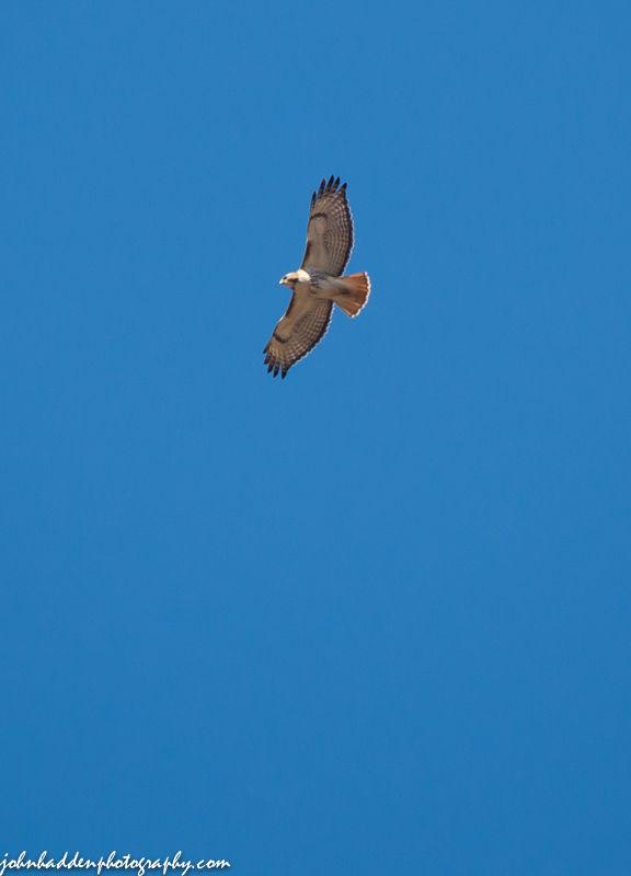
A red-tailed hawk wheels above our house
Morning Observation:
This morning in Huntington at 6:30AM it’s currently a balmy 62 degrees under mostly cloudy skies. Winds are out of the southeast at 0-3 mph. Relative humidity is 75%, dewpoint 54, barometric pressure 29.79” and falling slowly. We picked up 0.29” of rain in the past 24hrs (yesterday morning). Yesterday’s high was 66, and the overnight low was 43.
Forecast:
A cold front, currently out over the Midwest, will begin to push into the region by the early evening hours. Ahead of the front, we’ll be under the influence of a strong southerly airflow which will push above normal temperatures into the region today. We’ll see partly sunny skies with highs in the mid 70s to near 80 on south winds 15 to 20 mph gusting up to 35 mph. Tonight should be mostly cloudy with a chance of rain and a slight chance of thunderstorms after midnight. Lows will be in the mid 50s with south winds 15 to 20 mph and gusting up to 40 mph until midnight. Chance of rain is 30%.
Tuesday will bring rain and a slight chance of thunderstorms in the morning. Highs will be around 60 with temperature falling into the lower 50s in the afternoon as the cold front progresses. Winds will be out of the South at 15 to 20 mph and gusting up to 45 mph. Chance of rain is near 100%. Tuesday night rain will transition over to some snow with light snow accumulations especially over higher terrain. Lows will bottom out at around 20 with northwest winds 10 to 15 mph gusting up to 30 mph. Chance of precipitation is near 100%.
Chilly high pressure will build in Wednesday bringing partly sunny skies and highs only in the mid 30s with northwest winds 15 to 20 mph gusting up to 30 mph. Wednesday night should be clear with lows in the lower 20s. Temperatures should rebound nicely by Thursday.
Almanac:
Last year on this date we had a high of 44 and a low of 28. We picked up 0.12″ of rain.
Burlington norms for this date are highs of 54°F and lows of 34°F.
Record high was 84°F in 1968.
Record low was 17°F in 1923.
Sky Notes:
Sunrise: 6:10 AM EDT
Sunset: 7:35 PM EDT
Length of Visible Light: 14h 25m
Length of Day: 13h 25m
Tomorrow will be 2m 56s longer.
The Moon is waxing gibbous, 14d 16h old with 99% illumination.
Moonrise: 7:10 PM EDT
Moonset: 5:42 AM EDT
About Today’s Photo:
This red-tailed hawk was prowling the clear blue sky above our house the other day.
Nikon D600, Sigma 120-400mm lens @ 400mm, ISO 400, f/7.1, 1/1000″ exposure
Sunday, April 13, 2014

A tree swallow buzzes a male bluebird in our front field
Morning Observation:
This morning in Huntington at 7:15AM it’s currently 46 degrees and raining under overcast skies. Winds our out of the east at 3-6 mph. Relative humidity is 81%, dewpoint 40, barometric pressure 30.12” and falling. We’ve picked up 0.11” of rain overnight. Yesterday’s high was 61, and the overnight low was 39.
The Areal Flood Watch remains in effect for our region through Wednesday evening.
Forecast:
A warm front will move across the region during the day today and lift into Canada by the late afternoon and early evening hours. We’ll see rain this morning with a chance of thunderstorms as the front moves through. Highs will be in the lower 60s with south winds 10 to 15 mph gusting up to 25 mph. Chance of rain is 90%. Tonight should be partly cloudy with scattered showers and a chance of thunderstorms until midnight. Lows will be in the mid 50s with south winds 10 to 15 mph gusting up to 25 mph. Chance of rain is 30%.
Monday should start out partly sunny and get pretty warm with highs in the mid 70s to near 80 on south winds 15 to 20 mph gusting up to 30 mph. A cold front will move in from the west Monday night bringing mostly cloudy skies with scattered showers. Lows will be in the mid 50s with south winds 15 to 20 mph gusting up to 30 mph. Chance of rain is 50%. Unfortunately, it’s looking like our chances of seeing anything of the total eclipse of the moon early Tuesday morning (totality at 3:46AM) will be pretty much nil as clouds and rain will block our view…
Tuesday will be bring rain — heavy at times — with highs in the lower 60s and southwest winds 15 to 20 mph gusting up to 35 mph. Chance of rain is near 100%. There’s quite a bit of moisture associated with this storm, so a flood watch remains in effect for the region until Wednesday evening. Much colder air will move in behind the departing front Tuesday night changing any rain over to snow showers. We could see light snow accumulation especially in higher elevations. Lows will be in the lower 20s. Chance of precipitation is near 100%.
Almanac:
Last year on this date we had a high of 49 and a low of 33. We picked up 0.13″ of rain and 0.75″ of slushy snow.
Burlington norms for this date are highs of 54°F and lows of 34°F.
Record high was 84°F in 1945.
Record low was 16°F in 1914.
Sky Notes:
Sunrise: 6:11 AM EDT
Sunset: 7:33 PM EDT
Length of Visible Light: 14h 22m
Length of Day: 13h 22m
Tomorrow will be 2m 57s longer.
The Moon is waxing gibbous, 13d 16h old with 96% illumination.
Moonrise: 6:06 PM EDT
Moonset: 5:13 AM EDT
About Today’s Photo:
I mentioned yesterday that the bluebirds and the tree swallows arrived on the same day on Friday. Here’s proof! The swallow buzzed the bluebird repeatedly but then seemed to give up. We’ll see who gets which of our three front field nesting boxes…
Nikon D600, Sigma 120-400mm lens @ 400mm, ISO 400, f/7.1, 1/640″ exposure.
Saturday, April 12, 2014

Bluebirds return to our front field!
Morning Observation:
This morning in Huntington at 6:40AM it’s currently a frosty 29 degrees under clear skies. Winds are calm. Relative humidity is 95%, dewpoint 28, barometric pressure 30.09” and rising. Yesterday’s high was a lovely 61, and the overnight low was 28.
The NWS has issued an Areal Flood Watch for our region from 2:00PM this afternoon through Wednesday evening.
Signs of Spring: we had a pair of bluebirds and a tree swallow arrive yesterday morning!
Forecast:
High pressure over the region today will deliver a lovely April day before giving way to a warm front and associated surface low later tonight into Sunday. We’ll see mostly sunny skies with highs in the upper 50s and south winds around 10 mph, becoming northwesterly and gusting up to 25 mph this afternoon. Tonight should be partly cloudy with lows in the lower 40s and northwest winds around 10 mph, becoming southeasterly after midnight.
The aforementioned warm front will set up along the Canadian border by Sunday morning bringing mostly cloudy skies with a 50% chance of showers. Highs will be in the lower 60s with south winds 10 to 15 mph. Sunday night should be partly cloudy with a 40% chance of showers. Lows will be in the mid 50s with south winds around 10 mph.
The warm front will lift northward on Monday bringing partly sunny skies and above normal temperatures into the region. We’ll see highs in the mid 70s to near 80 with south winds 15 to 20 mph gusting up to 35 mph. Monday night will bring rain. It’ll be breezy and mild with lows in the mid 50s. Chance of rain is 60%. Rain will continue into Tuesday with heavy rains a good probability. With the high temperatures melting any remaining high elevation snowpack and the added rain, there may be some flooding in river valleys through this period.
Almanac:
Last year on this date we had a high of 36 and a low of 32.
Burlington norms for this date are highs of 53°F and lows of 34°F.
Record high was 82°F in 1945.
Record low was 16°F in 1926.
Sky Notes:
Sunrise: 6:13 AM EDT
Sunset: 7:32 PM EDT
Length of Visible Light: 14h 19m
Length of Day: 13h 19m
Tomorrow will be 2m 58s longer.
The Moon is waxing gibbous, 12d 16h old with 92% illumination.
Moonrise: 5:03 PM EDT
Moonset: 4:44 AM EDT
About Today’s Photo:
The bluebirds are back! This pair arrived yesterday morning and scouted out one of our nesting boxes in the front field. Interestingly, a tree swallow appeared at exactly the same time, and there was a bit of competition at one of the boxes. In years past, we’ve had the bluebirds in one box and the swallows in another. We’ll see who scores the coveted western-most box this year…
Nikon D600, Sigma 120-400mm lens @ 400mm, ISO 400, f/7.1, 1/640″ exposure
Friday, April 11, 2014

Dried Queen Ann’s Lace emerges from the snow
Morning Observation:
This morning in Huntington at 6:40AM it’s currently 40 degrees under mostly cloudy skies. Winds are calm. Relative humidity is 94%, dewpoint 39, barometric pressure 29.90” and rising rapidly. We picked up 0.02” of rain overnight. We are finally down to bare ground at the snow stake. Yesterday’s high was a lovely 60, and the overnight low was 40.
Forecast:
The cold front that pushed through the region this morning and is now just to our east will give way to high pressure later today and into Saturday. We’ll see partly sunny skies with a chance of rain this morning. Highs will be in the mid 50s with southwest winds around 10 mph, becoming northwesterly this afternoon. Chance of rain is 40%. Tonight should be partly cloudy with lows in the lower 30s and light and variable winds.
Saturday should be mostly sunny with highs in the lower 60s and south winds around 10 mph, becoming westerly in the afternoon. Saturday night should be partly cloudy with lows in the lower 40s and southwest winds 10 to 15 mph gusting up to 40 mph.
A cold front and associated low pressure will move through the region Sunday bringing cloudy skies with a 50% chance of showers and maybe a rumble of thunder in the morning. Highs will be in the mid 60s with south winds 10 to 15 mph and gusting up to 40 mph. Sunday night should be mostly cloudy with lows in the mid 50s.
Almanac:
Last year on this date we had a high of 40 and a low of 30. We picked up 0.06″ of rain.
Burlington norms for this date are highs of 53°F and lows of 33°F.
Record high was 84°F in 1945.
Record low was 12°F in 1974.
Sky Notes:
Sunrise: 6:15 AM EDT
Sunset: 7:31 PM EDT
Length of Visible Light: 14h 16m
Length of Day: 13h 16m
Tomorrow will be 2m 58s longer.
The Moon is waxing gibbous, 11d 18h old with 85% illumination.
Moonrise: 4:02 PM EDT
Moonset: 4:17 AM EDT
About Today’s Photo:
The snow has finally lost its grip here with only a few piles here and there in shaded northern aspects or where it was packed over the winter. This Queen Ann’s Lace head emerged from its winter entombment the other day.
Nikon D600, Sigma 105mm lens, ISO 400, f/11, 1/640″ exposure
Thursday, April 10, 2014

Layers of ice breaking up in our pond
Morning Observation:
This morning in Huntington at 6:45AM it’s currently a frosty 30 degrees under clear skies. Winds are calm. Relative humidity is 76%, dewpoint 24, barometric pressure 30.02” and rising. We picked up 0.02” of melted precipitation yesterday and have a spotty 2” of snow and ice lingering at the snow stake. Yesterday’s high was 44, and the overnight low got down to 23.
Forecast:
With high pressure sliding to our east, this morning’s chilly temperatures should give way quickly to a lovely early spring day. We’ll see sunny skies with highs in the mid 50s to 60 today with south winds 15 to 20 mph gusting up to 35 mph this afternoon. A cold front will approach the region tonight bringing showers. Lows will be in the upper 30s with southwest winds 15 to 20 mph. Chance of rain is 80%.
Friday should start out with a chance of showers in the morning giving way to partly cloudy skies as high pressure builds in. Highs will be in the mid 50s with west winds around 10 mph. Chance of rain is 50%. Friday night should be partly cloudy with lows in the lower 30s and south winds around 10 mph.
Saturday’s looking partly sunny with highs in the lower 60s and south winds 10 to 15 mph. Saturday night should be partly cloudy with lows in the lower 40s. At this point Sunday’s looking nice with temps in the 60s, but rain enters the picture Sunday night.
Almanac:
Last year on this date we had a high of 48 and a low of 40. We picked up 0.19″ of rain. The ice was off our pond, and the wood frogs were croaking!
Burlington norms for this date are highs of 52°F and lows of 33°F.
Record high was 81°F in 1945.
Record low was 16°F in 1975.
Sky Notes:
Sunrise: 6:17 AM EDT
Sunset: 7:30 PM EDT
Length of Visible Light: 14h 13m
Length of Day: 13h 13m
Tomorrow will be 2m 59s longer.
The Moon is waxing gibbous, 10d 16h old with 78% illumination.
Moonrise: 3:02 PM EDT
Moonset: 3:48 AM EDT
About Today’s Photo:
The ice is breaking up in our pond. The winter deposited several distinct layers this past season creating an interesting pattern this spring. Can the wood frogs be far behind?
Nikon D600, Nikon 18-35mm lens @ 18mm, ISO 400, f/14, 1/640″ exposure.
Wednesday, April 9, 2014
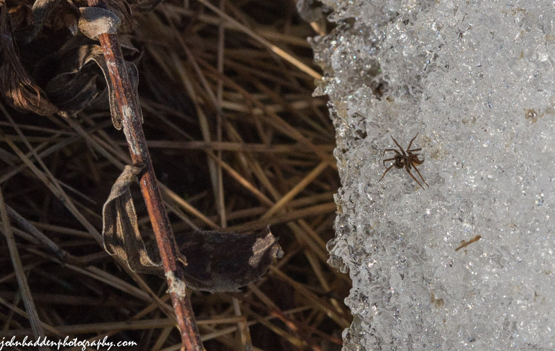
A tiny spider on spring corn snow
Morning Observation:
This morning in Huntington at 7:05AM it’s currently 36 degrees and drizzling lightly under overcast skies. Wind are calm. Relative humidity is 89%, dewpoint 33, barometric pressure 29.63” and rising. We picked up 0.06” of rain in the past 24hrs. Snowpack is down to a spotty 2”. Yesterday’s high was 57, and the overnight low was 35.
Signs of Spring: the phoebe arrived yesterday on the same date as last year. Got my eyes and ears peeled or bluebirds…
Forecast:
Cold air advection continues this morning on a northwesterly airflow, so expect plenty of clouds this morning with the chance a morning drizzle or mountain snow showers. High pressure will push into the region this afternoon bringing clearing skies. It’ll be on the cool side with highs only around 40 with northwest winds 10 to 15 mph. Chance of precipitation is 20%. Tonight should be mostly clear and cool with lows in the mid 20s and northwest winds 10 to 15 mph until midnight, becoming light and variable.
Thursday should be partly sunny with highs in the upper 50s and south winds 15 to 20 mph gusting up to 35 mph. A weak cold front will move across the region Thursday night bringing showers. It’ll be breezy with lows in the upper 30s and southwest winds 20 to 25 mph gusting up to 35 mph. Chance of rain is 70%.
Friday’s looking partly sunny with highs in the mid 50s and west winds around 10 mph. Friday night should be partly cloudy with lows in the upper 30s.
Almanac:
Last year on this date we had a high of 52 and a low of 41.
Burlington norms for this date are highs of 51°F and lows of 32°F.
Record high was 76°F in 1945.
Record low was 14°F in 1997.
Sky Notes:
Sunrise: 6:18 AM EDT
Sunset: 7:29 PM EDT
Length of Visible Light: 14h 09m
Length of Day: 13h 10m
Tomorrow will be 3m 0s longer.
The Moon is waxing gibbous, 9d 16h old with 70% illumination.
Moonrise: 2:03 PM EDT
Moonset: 3:18 AM EDT
About Today’s Photo:
Insect (okay, technically arachnid) life gets going as soon as the snow clears. As I walked through the front field the other day, countless little spiders scurried around over the corn snow and into the flattened dried grasses that were emerging from their winter beds.
Nikon D600, Sigma 105mm lens, ISO 1260, f/16, 1/1250″ exposure.
Tuesday, April 8, 2014

The first quarter moon in late afternoon light
Morning Observation:
This morning in Huntington at 7:05AM it’s currently a blustery 47 degrees under overcast skies. Winds are out of the southeast at 5-10 mph. Relative humidity is 81%, dewpoint 41, barometric pressure 29.37” and falling rapidly. We picked up 0.33” of rain overnight and had a few flashes of lightning and rumbles of thunder around 4:00AM. Snowpack is down to 7” at the stake but there are plenty of bare spots around. Yesterday’s high was 59, and the overnight low was 40.
Forecast:
Low pressure will move through the eastern Great Lakes early today and into southern Quebec this afternoon. This will bring periods of rain and drizzle to the region today. We’ll see drizzle and rain likely with a slight chance of thunderstorms this morning, then numerous showers this afternoon. Highs will be in the mid 50s with southeast winds 15 to 20 mph, becoming southwesterly this afternoon. Chance of rain is 70%. Tonight should be cloudy with scattered rain showers until midnight, then a chance of rain or higher elevation snow showers after midnight as temperature drop. Lows will be in the lower 30s with west winds 10 to 15 mph. Chance of precipitation is 50%.
Wednesday should start out mostly cloudy with a slight chance of rain or snow showers in the morning, then become partly sunny in the afternoon as a cold front and associated high pressure moves in. Highs will be in the lower 40s with northwest winds 15 to 20 mph gusting up to 30 mph. Chance of precipitation is 20%. Wednesday night should be mostly clear with lows in the upper 20s and southwest winds 10 to 15 mph gusting up to 25 mph.
Thursday’s looking partly sunny and breezy with highs in the upper 50s and south winds 20 to 25 mph gusting up to 35 mph. A cold front will swing through Thursday night bringing showers. It’ll be breezy with lows in the upper 30s. Chance of rain is 60%.
Almanac:
Last year on this date we had a high of 55 and a low of 38. Phoebes, bluebirds and coltsfoot all made their first appearances.
Burlington norms for this date are highs of 51°F and lows of 32°F.
Record high was 73°F in 1991.
Record low was 11°F in 1972.
Sky Notes:
Sunrise: 6:20 AM
Sunset: 7:27 PM
Length of Visible Light: 14h 06m
Length of Day: 13h 07m
Tomorrow will be 2m 59s longer.
The Moon is waxing gibbous, 8d 16h old with 61% illumination.
Moonrise: 1:06 PM
Moonset: 2:45 AM
About Today’s Photo:
I love it when the moon shines brightly in the daytime. I captured this view of the first quarter moon the other day near sunset. There’s a total eclipse coming up on the morning of April 15. More details to come!
Nikon D600, Nikon 24-120mm lens @ 120mm, ISO 250, f/18, 1/60″ exposure
Monday, April 7, 2014

Peek-a-boo!
Morning Observation:
This morning in Huntington at 7:55AM it’s currently 31 degrees under clear skies. Winds are calm. Relative humidity is 95%, dewpoint 30, barometric pressure 30.16″. Snowpack is down to 9.5″ at the stake though our south-facing front field is about half bare now. Yesterday’s high was 51, and the overnight low was 26.
Forecast:
Low pressure located across the Mississippi Valley will race into the Ohio Valley by this evening and into southern Canada by Tuesday bringing clouds with rain showers by sunset this evening along with some gusty winds along the western slopes. We’ll see sunny skies this morning, then partly sunny skies later in the day. Highs will be in the lower 50s with light and variable winds, becoming southerly around 10 mph this afternoon. Rain should arrive by nightfall, and it will be breezy with lows in the upper 30s and southeast winds 15 to 25 mph gusting up to 35 mph. Chance of rain is near 100% with precipitable moisture in the range of 0.20″ – 0.30″.
Tuesday should be cloudy with a chance of showers and areas of drizzle. Highs will be in the lower 50s with south winds 10 to 15 mph, becoming southwesterly in the afternoon and gusting up to 30 mph. Chance of rain is 50%. Tuesday night should be cloudy with a chance of rain or snow showers as a cold front moves in behind the departing low. Lows will be in the lower 30s with west winds 10 to 15 mph gusting up to 25 mph. Chance of precipitation is 40%.
Wednesday’s looking partly sunny and cooler with a chance of rain or snow showers. Highs will be in the lower 40s with northwest winds 10 to 15 mph gusting up to 25 mph. Chance of precipitation is 50%. Wednesday night should be mostly clear with lows in the mid 20s. Warmer and drier weather looks in store for the end of the week.
Almanac:
Last year on this date we had a high of 53 and a low of 28.
Burlington norms for this date are highs of 50°F and lows of 32°F.
Record high was 83°F in 1991.
Record low was 2°F in 1972.
Sky Notes:
Sunrise: 6:22 AM
Sunset: 7:26 PM
Length of Visible Light: 14h 03m
Length of Day: 13h 04m
Tomorrow will be 3m 1s longer.
The Moon is in its first quarter, 7d 17h old with 52% illumination.
Moonrise: 12:09 PM
Moonset: 2:08 AM
About Today’s Photo:
This pussy willow was juuuust starting to pop out in our front field yesterday afternoon. Yup, spring is here!
Nikon D600, Sigma 105mm lens, ISO 400, f/5, 1/2000″ exposure.
