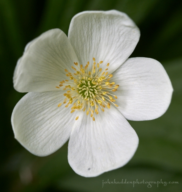
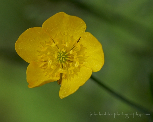
Saturday, June 30, 2018
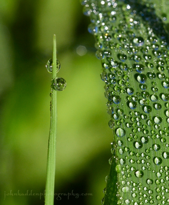
A dew soaked buttercup
Morning Observation:
This morning in Huntington at 7:30AM it’s currently 66 degrees under mostly sunny skies. Winds are calm. Relative humidity is 99%, dewpoint 65, barometric pressure 29.99” and rising. Yesterday’s high was 85, and the overnight low was 61.
There is a Heat Advisory in effect for our region through 10:00PM Monday.
Forecast:
A mid-level heat ridge building into the northeastern U.S. from the Midwest and Ohio Valley regions will set the stage for a prolonged heat wave for our region through at least Thursday. There’s the potential for scattered thunderstorms later today into this evening—mostly likely north along the Canadian border. Some storms may be severe with damaging winds the primary threat. Dangerously hot and humid conditions will peak Sunday and Monday, but high temperatures will reach into the 90s in most valley locations through at least Thursday of next week. Expect little relief during overnight hours as temperatures will remain in the 70s through much of the nighttimes with muggy conditions.
We’ll see partly cloudy skies today with a slight chance of showers this afternoon. It’ll be hot with a high near 92 in valley locations and pushing 90 here in Huntington. Winds will be out of the southwest at 6 to 13 mph. Tonight should be mostly cloudy with a 50% chance of showers and thunderstorms, mainly before 3:00AM. It’ll be mostly cloudy with a low around 69 and northwest winds 5 to 8 mph becoming calm after midnight.
Sunday should be mostly sunny and hot with a high near 96 in valley locations. There is a 20% chance of showers and thunderstorms in the afternoon. Winds should be calm. Sunday night should be mostly clear with a low around 72 and south winds 3 to 8 mph.
Monday’s looking sunny and hot with a high near 97 in valley locations and southwest winds 9 to 11 mph. Monday night should be partly cloudy with a low around 72 and south winds 3 to 6 mph.
Almanac:
Last year on this date we had a high of 80 and a low of 61. We picked up a whopping 3.35″ of rain.
Burlington averages for this date are a high of 80 and a low of 59.
The record high was 93 in 1936.
The record low was 42° in 1936.
Sky Notes:
Sunrise: 5:13AM
Sunset: 8:28PM
Length of Visible Light: 16h 25m
Length of Day: 15h 14m
Tomorrow will be 1 minutes 27 seconds longer
The Moon is waning gibbous, 16.6 days old with 96% illumination.
Moonrise: 9:25PM
Moonset: 6:11AM
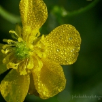
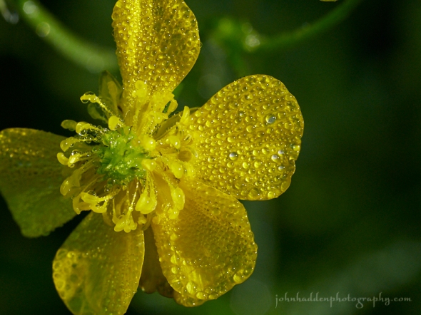
About Today’s Photo:
Morning dew soaks a buttercup in our front field.
Panasonic GX8, Olympus 60mm macro lens, ISO 800, f/8, 1/400″ exposure.
Friday, June 29, 2018

A dew soaked morning glory
Morning Observation:
This morning in Huntington at 7:10AM it’s currently 62 degrees under clear skies. Winds are calm. Relative humidity is 99%, dewpoint 61, barometric pressure 29.88” and rising slowly. We picked up 0.34” of rain in the past 24hrs giving us a solid 1” of much needed rain from the storm. Yesterday’s high was 73, and the overnight low was 57.
There is a Heat Advisory in place for our region from noon Sunday until 10:00PM Monday.
Forecast:
High pressure building into the region today will lead to a prolonged period of hot and humid weather through the weekend. Expect well above normal temperatures with heat index values above 95 degrees daily through at least the Sunday. Dangerously hot and humid conditions are expected from Saturday onward, so if you know of anyone living alone who may be vulnerable to the heat, have a plan to check them during the period—especially Monday when valley locations may hit 100 degrees. We can expect little relief overnight as temperatures will remain in the 70s through much of early next week. After a dry, hot Sunday, the chance for thunderstorms returns Monday and Tuesday. Temperatures are expected to moderate by Thursday.
We’ll see mostly sunny skies today with a high near 84 and light and variable winds becoming northwesterly 5 to 9 mph in the morning. A weak shortwave trough will skirt the international border this afternoon bringing a 20% chance of showers north. Tonight should be partly cloudy with a low around 64 and light and variable winds.
Saturday should be mostly sunny, hot and humid with a high near 91 and south winds 7 to 14 mph. Saturday night should be partly cloudy with a low around 72 and southwest winds 3 to 8 mph. There’s a 40% chance of showers and thunderstorms along the international border as a brief but potentially strong disturbance moves though in the afternoon.
Sunday’s looking mostly sunny and hot with a high near 95 and light and variable winds. Sunday night should be mostly clear with a low around 72 and south winds 3 to 5 mph.
Almanac:
Last year on this date we had a high of 68 and a low of 48. We picked up 0.05″ of rain.
Burlington averages for this date are a high of 79° and a low of 58°.
The record high was 96° in 1946.
The record low was 37° in 1919.
Sky Notes:
Sunrise: 5:14AM
Sunset: 8:27PM
Length of Visible Light: 16h 23m
Length of Day: 15h 13m
Tomorrow will be 1 minutes 30 seconds longer
The Moon is waning gibbous, 15.7 days old with 99% illumination.
Moonrise: 8:28PM
Moonset: 5:34AM
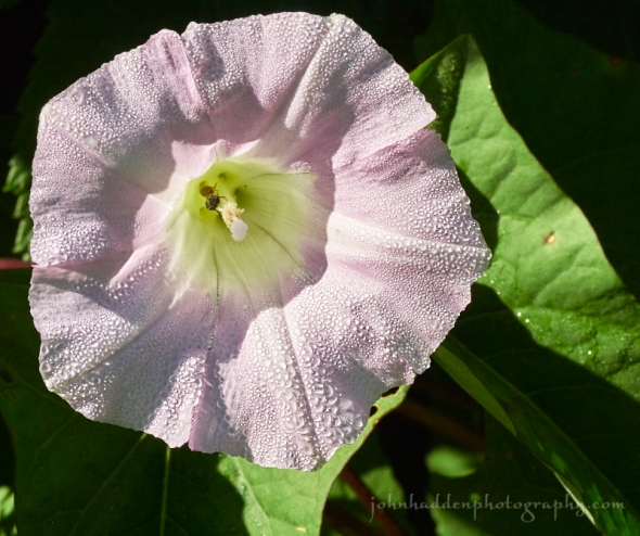
About Today’s Photo:
Morning glories are starting to bloom in our front field. This dew soaked bloom sparkles in the morning sun. Note the two beetles tucked deep in the flower.
Panasonic GX8, Olympus 60mm macro lens, ISO 800, f/16, 1/640″ exposure.
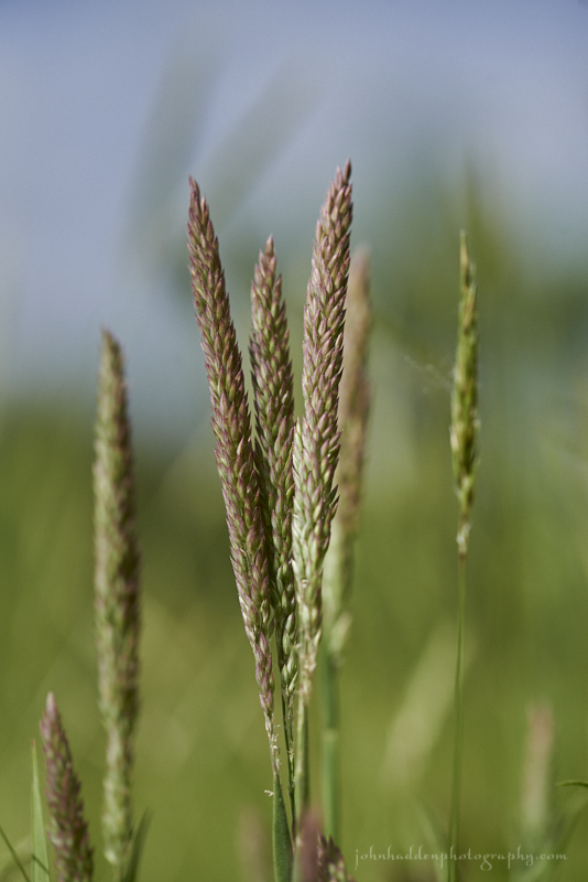
Thursday, June 28, 2018

Dew bespeckled timothy in our front field
Morning Observation:
This morning in Huntington at 8:00AM it’s currently 63 degrees and raining lightly under overcast skies. Winds are calm. Relative humidity is 98%, dewpoint 63, barometric pressure 29.74” and falling slowly. We picked up 0.66” of rain in the past 24hrs. Yesterday’s high was 75, and the overnight low was 61.
Forecast:
Low pressure currently centered over western New York will continue to bring showers across the region today with a few rumbles of thunder possible. Any showers that develop will have the potential to produce locally heavy rainfall. As the low moves out of the region Friday, an unusually hot airmass will move in and park itself over the region. This will begin a prolonged period of dangerously hot and humid conditions with several days above 90 degrees without much chance for overnight cooling. The hottest day looks to be Sunday where temperatures will warm into the mid to upper 90s to 100 in valley locations with records potentially being set. Relief may not arrive until midweek next week…
Showers and thunderstorms are likely today before 3:00PM, then a chance of showers and thunderstorms after 4:00PM. Some of the storms could produce heavy rain. Highs will be near 74 with south winds 5 to 8 mph. Chance of precipitation is 80% with rainfall amounts between a quarter and half of an inch possible. Tonight should bring a 30% chance of showers and thunderstorms before 8:00PM, then a slight chance of showers between later. It’ll be cloudy, then gradually becoming partly cloudy, with a low around 62 and calm winds. Precipitation amounts of less than a tenth of an inch, except higher amounts possible in thunderstorms.
Friday should be sunny and warm with a high near 87 and light and variable winds becoming northwesterly 5 to 9 mph in the morning. Friday night should be partly cloudy with a low around 64 and calm winds becoming southerly around 5 mph after midnight.
Saturday’s looking mostly sunny, hot, and muggy with a high near 90 and south winds 6 to 14 mph becoming westerly in the afternoon. Saturday night should be partly cloudy with a low around 71 and southwest winds around 6 mph becoming calm after midnight.
Almanac:
Last year on this date we had a high of 73 and a low of 47. We picked up 0.44″ of rain.
Burlington averages for this date are a high of 79° and a low of 58°.
The record high was 95° in 1991.
The record low was 43° in 1927.
Sky Notes:
Sunrise: 5:11AM
Sunset: 8:41PM
Length of Visible Light: 16h 43m
Length of Day: 15h 29m
Tomorrow will be 0 minutes 31 seconds shorter
The Moon is the full “Strawberry” moon (Northeast Native American)
15 days old with 100% illumination.
Moonrise: 9:01PM
Moonset: 5:36AM
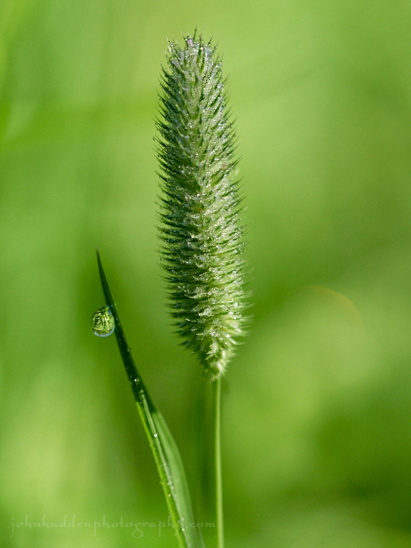
About Today’s Photo:
A timothy seedhead and a drop of dew. Lovely…
Panasonic GX8, Olympus 60mm macro lens, ISO 800, f/2.8, 1/3200″ exposure
Wednesday, June 27, 2018

Tiny drops of morning dew on grasses in the front field
Morning Observation:
This morning in Huntington at 7:45AM it’s currently 64 degrees under mostly cloudy skies. Winds are calm. Relative humidity is 84%, dewpoint 59, barometric pressure 30.04” and steady. Yesterday’s high was 78, and the overnight low was 51.
Forecast:
We’ve got another day of dry and seasonable conditions on tap today before low pressure moving out of the Great Lakes pushes into the region this afternoon through Thursday evening. Showers will arrive in western New York this afternoon and make their way into Vermont by this evening making for widespread rain into Thursday. We could see 0.75″-1″ of rain out of the system with locally higher amounts. We could use it! Warmer and drier weather returns for Friday before dangerously hot and humid conditions arrive from Saturday through early next week. Temperatures Sunday could push 100 degrees in valley locations.
We’ll see mostly cloudy skies today with a high near 78 and south winds 6 to 13 mph. Tonight showers are likely mainly after 10:00PM. Rain could be heavy at times. Lows will be around 62 with south wind around 10 mph gusting to 21 mph. Chance of precipitation is 80% with precipitation amounts between a quarter and half of an inch possible.
Thursday showers are likely with rain heavy at times. Highs will be near 75 with south winds around 8 mph becoming southwesterly in the afternoon. Chance of precipitation is 90% with precipitation amounts between a quarter and half of an inch possible. Thursday night showers are likely mainly before 7:00PM. It’ll be mostly cloudy with a low around 61 and northwest winds around 5 mph becoming light and variable after midnight. Chance of precipitation is 60% with precipitation amounts of less than a tenth of an inch possible.
Friday’s looking mostly sunny with a high near 84 and calm winds becoming westerly 5 to 7 mph in the morning. Friday night should be partly cloudy with a low around 61 and calm winds.
Almanac:
Last year on this date we had a high of 72 and a low of 48. We picked up 0.02″ of rain.
Burlington averages for this date are a high of 79 and lows of 59.
The record high was 96°F in 1999 (we had a high of 88).
The record low was 44°F in 1927.
Sky Notes:
Sunrise: 5:10AM
Sunset: 8:41PM
Length of Visible Light: 16h 43m
Length of Day: 15h 30m
Tomorrow will be 0 minutes 27 seconds shorter
The Moon is waxing gibbous, 14 days old with 99% illumination.
Moonrise: 8:12PM
Moonset: 4:51AM
About Today’s Photo:
Sunny mornings after a good dew fall make for interesting photo opportunities if you’re willing to slow down and take a look. Tiny droplets bespeckle grasses and sparkle in the morning sun out in our front field.
Panasonic GX8, Olympus 60mm macro lens, ISO 800, f/8, 1/640″ exposure.
Tuesday, June 26, 2018

Drops of rain on foliage
Morning Observation:
This morning in Huntington at 7:50AM it’s currently 54 degrees under clear skies. Winds are calm. Relative humidity is 98%, dewpoint 53, barometric pressure 30.28” and rising slowly. Yesterday’s high was 68, and the overnight low was 40.
Forecast:
High pressure over the region this morning will continue to provide mostly clear skies and seasonal temperatures today before low pressure tracking through the Great Lakes brings widespread rain late Wednesday night through Thursday. Potentially record-setting hot and humid conditions are expected to develop Friday through early next week with temperatures hitting the mid 90s region wide by Sunday.
We’ll see sunny skies today with a high near 77 and calm winds becoming southwesterly around 6 mph in the afternoon. Tonight should be mostly clear with a low around 51 and south winds 3 to 5 mph.
Wednesday should be mostly sunny with a high near 80 and south winds 6 to 14 mph. Wednesday night showers are likely late. Lows will be around 62 with south winds 8 to 10 mph. Chance of precipitation is 80% with precipitation amounts between a tenth and quarter of an inch possible.
Thursday showers are likely in the morning, with showers and possibly a thunderstorm in the afternoon. Highs will be near 75 with south winds 8 to 10 mph. Chance of precipitation is 80% with rainfall amounts between a quarter and half of an inch possible. Thursday night showers are likely. It’ll be mostly cloudy with a low around 61 and light south winds. Chance of precipitation is 60% with precipitation amounts of less than a tenth of an inch possible.
Almanac:
Last year on this date we had a high of 71 and a low of 47. We picked up 0.39″ of rain.
Burlington averages for this date are a high of 79 and a low of 58.
The record high was 96°F in 2007 (we had a high of 92).
The record low was 41°F in 1979.
Sky Notes:
Sunrise: 5:10AM
Sunset: 8:41PM
Length of Visible Light: 16h 44m
Length of Day: 15h 30m
Tomorrow will be 0 minutes 23 seconds shorter
The Moon is waxing gibbous, 13 days old with 96% illumination.
Moonrise: 7:19PM
Moonset: 4:10AM
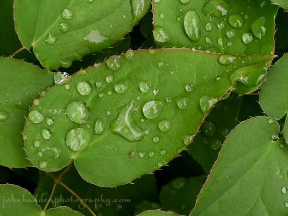
About Today’s Photo:
My eye was drawn to the raindrops on these leaves in our ornamental garden the other day. I like the spikey margins of the leaves…
Panasonic GX8, Olympus 60mm macro lens, ISO 800, f/8, 1/160″ exposure.
Monday, June 25, 2018

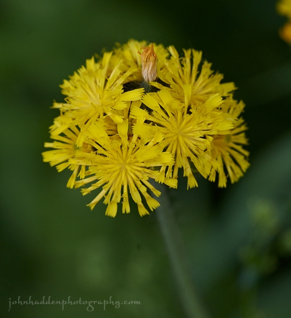
Yellow hawkweed blooming in our front field
Morning Observation:
This morning in Huntington at 8:05AM it’s currently 56 degrees under mostly cloudy skies. Winds are calm. Relative humidity is 93%, dewpoint 54, barometric pressure 29.99” and rising rapidly. We picked up 0.23” of rain in the past 24hrs. Yesterday’s high was 66, and the overnight low was 54.
Forecast:
High pressure building in behind a departing cold front will bring cool, dry, and increasingly sunny conditions to the region today. Warmer temperatures return for Tuesday and Wednesday before low pressure tracking through the Great Lakes brings widespread rain Wednesday night through Thursday. Hot and humid conditions are expected to develop Friday through the weekend with temperatures pushing into the low 90s by Sunday.
We’ll see mostly sunny skies today with a high near 72 and north winds 5 to 10 mph increasing to 11 to 16 mph in the afternoon and gusting to 26 mph. Tonight should be clear with a low around 43 and northwest winds around 5 mph becoming calm in the evening.
Tuesday should be sunny with a high near 79 and calm winds becoming southwesterly around 6 mph in the afternoon. Tuesday night should be partly cloudy with a low around 54 and south winds around 5 mph.
Wednesday’s looking mostly cloudy with a 30% chance of showers after 5:00PM. Highs will be near 79 with south winds 5 to 10 mph. Precipitation amounts of less than a tenth of an inch are possible. Wednesday night showers are likely. It’ll be cloudy with a low around 61 and south winds around 9 mph. Chance of precipitation is 70% with precipitation amounts between a quarter and half of an inch possible.
Almanac:
Last year on this date we had a high of 75 and a low of 50. We picked up 0.05″ or rain.
Burlington averages for this date are a high of 79 and lows of 58.
The record high was 94°F in 1995.
The record low was 39°F in 1979.
Sky Notes:
Sunrise: 5:10AM
Sunset: 8:41PM
Length of Visible Light: 16h 44m
Length of Day: 15h 31m
Tomorrow will be 0 minutes 19 seconds shorter
The Moon is waxing gibbous, 12 days old with 92% illumination.
Moonrise: 6:21PM
Moonset: 3:35AM
About Today’s Photo:
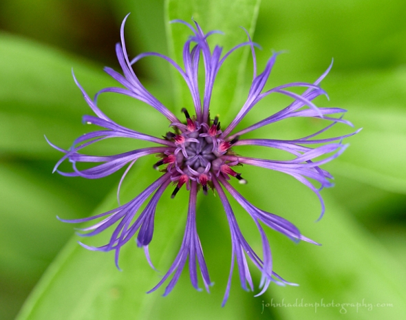
Yellow hawkweed (Hieracium caespitosum, A.K.A meadow hawkweed, field hawkweed, king devil, yellow paintbrush, devil’s paintbrush, yellow devil, yellow fox-and-cubs, and yellow king-devil), blooms prolifically in fields and along roadways this time of year. This European native is a rugged species that grows and spreads via rhizomes and stolons and can be somewhat invasive. It can handle disturbed and low fertility soils.
Nikon D600, Sigma 105mm macro lens, ISO 400, f/8, 1/400″ exposure.
Thursday, June 21, 2018; the Summer Solstice
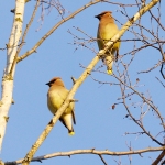
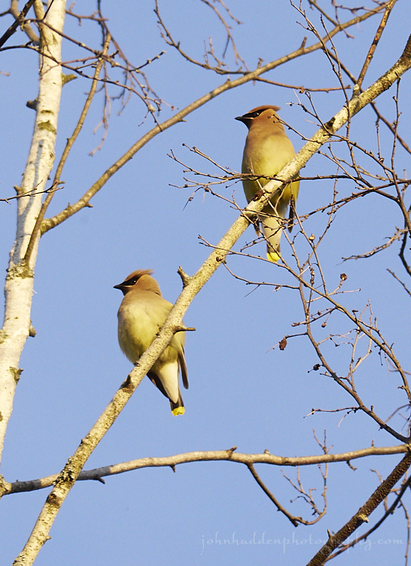
A pair of cedar waxwings in the evening light
Happy Solstice!
Morning Observation:
This morning in Huntington at 7:55AM it’s currently 60 degrees under partly cloudy skies. Winds are light. Relative humidity is 73%, dewpoint 51, barometric pressure 29.82” and rising slowly. Yesterday’s high was 79, and the overnight low was 56.
Forecast:
A weak cold front dropping southward out of Canada this morning will start the day with a mix of sun and clouds, but high pressure building in from the north will quickly turn skies mostly sunny by this afternoon. High pressure will dominate our weather through Friday before low pressure arrives from the Great Lakes bringing unsettled conditions for the weekend with periods of rain likely from Saturday afternoon through Sunday night.
We’ll see partly cloudy skies through mid morning, then gradual clearing with a high near 71 and light and variable winds becoming northerly 6 to 11 mph in the morning. Tonight should be clear with a low around 43 and north winds around 5 mph becoming calm in the evening.
Friday should be sunny with a high near 80 and light and variable winds becoming southerly 5 to 8 mph in the morning. Friday night should be partly cloudy with a low around 56 and south winds 3 to 7 mph.
Saturday should be mostly cloudy with a 40% chance of showers after 10:00AM. Highs will be near 74 with southeast winds 6 to 8 mph. Precipitation amounts of less than a tenth of an inch possible. Saturday night showers are likely. It’ll be cloudy with a low around 57 and southeast winds around 5 mph becoming calm after midnight. Chance of precipitation is 60% with precipitation amounts between a tenth and quarter of an inch possible.
Almanac:
Last year on this date we had a high of 73 and a low of 54. We picked up 0.50″ of rain.
Burlington averages for this date are a high of 78 and lows of 57.
The record high was 97°F in 2012 (we had a high of 92).
The record low was 42°F in 1926.
Sky Notes:
Sunrise: 5:09AM
Sunset: 8:40PM
Length of Visible Light: 16h 45m
Length of Day: 15h 31m
Tomorrow will be 0 minutes 1 seconds shorter
The Moon is waxing gibbous, 8.3 days old with 59% illumination.
Moonrise: 2:09PM
Moonset: 1:38AM
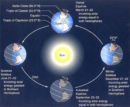
The Summer Solstice occurred this morning at 6:007AM. The Solstice occurs when the Earth’s rotational axis is most inclined toward the Sun. On the summer solstice, Earth’s maximum axial tilt toward the Sun is 23.44°. In the northern hemisphere, this marks the beginning of astronomical summer and is the longest day of the year. Here’s a handy graphic:
About Today’s Photo:
We have a pair of cedar waxwings in residence this summer. I’m not sure where they’re nesting, but I see and hear them often as they hover and dive for insects in the air. The handsome pair posed for me in the dying birch by our front porch catching the last light of spring as the sun was setting last evening.
Panasonic GX8, Lumix 100-300mm lens @ 300mm, ISO 800, f/8, 1/400″ exposure.
Wednesday, June 20, 2018

A mayapple blossom blooming at the edge of the woods
Morning Observation:
This morning in Huntington at 7:10AM it’s currently 52 degrees under clear skies. Winds are calm. Relative humidity is 98%, dewpoint 52, barometric pressure 29.90” and steady. Yesterday’s high was 72, and the overnight low was 45.
Forecast:
We’ll see a mostly sunny day today, however, a cold front dropping southward out of Canada will bring a chance of showers to northern areas near and just south of the border this evening through midnight. High pressure will return for Thursday and Friday bringing pleasant conditions. Low pressure moving out of the Great Lakes on Saturday will bring unsettled conditions for the weekend with periods of rain likely, along with the chance for a few rumbles of thunder.
We’ll see sunny skies today with a high near 80 and light and variable winds becoming southwesterly 5 to 9 mph in the morning. Tonight should bring increasing clouds with a 30% chance of showers north, mainly between 11:00pm and 3:00am. Lows will be around 53 with light and variable winds.
Thursday (the Summer Solstice) should be sunny with a high near 71 and calm winds becoming northwesterly 5 to 8 mph in the afternoon. Thursday night should be clear with a low around 46 and north winds around 5 mph becoming calm in the evening.
Friday’s looking sunny with a high near 80 and calm winds becoming southwesterly 5 to 7 mph in the afternoon. Friday night should bring increasing clouds with a low around 56 and calm winds becoming southerly around 6 mph after midnight.
Almanac:
Last year on this date we had a high of 75 and a low of 59. We picked up 0.81″ of rain.
Burlington averages for this date are a high of 78 and lows of 57.
The record high was 95°F in 2012 (we had a high of 92).
The record low was 35°F in 1918.
Sky Notes:
Sunrise: 5:08AM
Sunset: 8:40PM
Length of Visible Light: 16h 45m
Length of Day: 15h 31m
Tomorrow will be 0 minutes 2 seconds longer
The Moon is in its first quarter, 7 days old with 48% illumination.
Moonrise: 1:02PM
Moonset: 1:09AM
About Today’s Photo:
Mayapples are woodland plants that typically grow in colonies aided by their rhizomeous roots. The pretty umbrella like leaves and delicate single white blossom are hard to miss.
Nikon D600, Sigma 105mm macro lens, ISO 400, f/13, 1/125″ exposure.
Tuesday, June 19, 2018
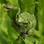
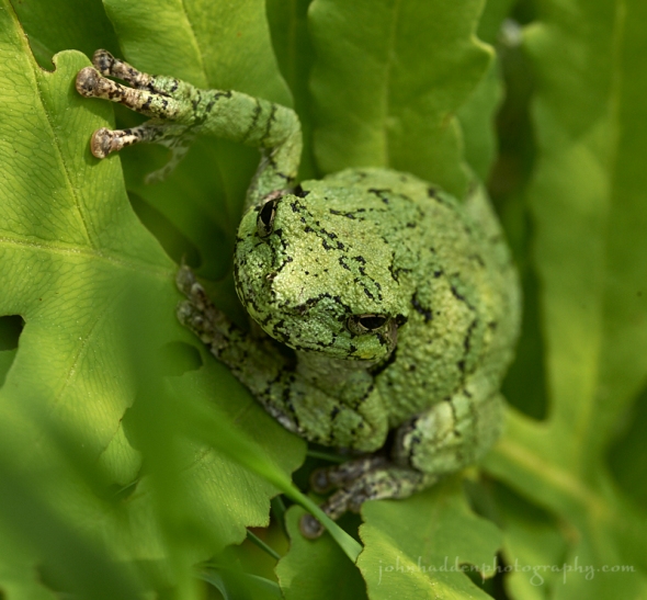
A grey tree frog by the side of our pond
Morning Observation:
This morning in Huntington at 7:00AM it’s currently 59 degrees under cloudy skies. Winds are out of the south at 3-6 mph. Relative humidity is 92%, dewpoint 57, barometric pressure 29.81” and rising rapidly. We picked up 1.00” of rain in the past 24hrs. Yesterday’s high was 83, and the overnight low was 59.
Forecast:
High pressure building into the region this morning behind the departing cold front will bring mainly dry and seasonable conditions to the region through the end of the work week. Temperatures will be in the low 70s today and warm into the low 80s heading towards the weekend. The next chance of appreciable rainfall will arrive over the weekend as low pressure lifts northeast from the Ohio Valley.
We’ll see mostly cloudy skies this morning giving way to sunny skies this afternoon. Highs will be near 74 with northwest winds at 11 to 13 mph. Tonight should be clear with a low around 49 and light and variable winds.
Wednesday should be sunny with a high near 81 and calm winds becoming southwesterly 5 to 8 mph in the morning. Wednesday night should be partly cloudy with a low around 51 and west winds around 6 mph becoming calm in the evening.
Thursday’s looking sunny with a high near 70 and light northwest winds increasing to 5 to 10 mph in the morning. Thursday night should be clear with a low around 47 and light and variable winds.
Almanac:
Last year on this date we had a high of 82 and a low 67. We picked up 0.47″ of rain.
Burlington averages for this date are a high of 77 and a low of 57.
The record high was 100°F in 1995.
The record low was 37°F in 1946.
Sky Notes:
Sunrise: 5:08AM
Sunset: 8:40PM
Length of Visible Light: 16h 44m
Length of Day: 15h 31m
Tomorrow will be 0 minutes 6 seconds longer
The Moon is a waxing crescent, 6.2 days old with 37% illumination.
Moonrise: 11:53AM
Moonset: 12:38AM
About Today’s Photo:
Grey tree frogs are singing loudly this time of year. They’re quite difficult to spot as their camouflage allows them to blend in so well with their surroundings. I was lucky enough that this little fellow was actually sitting on one of the Adirondack chairs on our pond dock yesterday morning when I took a swim. I figured he (she?) didn’t really want to be out in the rising sun, so I helped it into the ferns. Note the round pads on the feet of the frog. There are sticky suction-cup like pads on the toes that allow the frogs to cling to vertical surfaces. You’ll often hear these frogs calling from the trees near ponds and streams. This individual might have recently metamorphized from its tadpole form as the emerald green color is indicative of a youngster.
Nikon D600, Sigma 105mm macro lens, ISO 400, f/13, 1/250″ exposure.
Monday, June 18, 2018

Up close with a buttercup blossom
Morning Observation:
This morning in Huntington at 7:05AM it’s currently a muggy 67 degrees under partly cloudy skies. Winds are calm. Relative humidity is 90%, dewpoint 64, barometric pressure 29.85” and falling slowly. Yesterday’s high was 86, and the overnight low was 62.
Forecast:
We’ve got an active weather day on tap today with several rounds of potentially strong to severe storms, along with very warm and humid conditions. Thunderstorms will develop ahead of a cold front—mainly this afternoon into the evening—then come to an end later tonight. Any thunderstorms that form will be capable of producing very heavy downpours with potential for isolated flash flooding, gusty winds, and frequent lightning. Temperatures are expected to reach the mid to upper 80s this afternoon, with localized valley locations around 90. This combined with dewpoints around 70 will create heat index values well into the 90s. It’ll be muggy! Much cooler and drier air will follow the frontal passage making for a pleasant day on Tuesday.
Morning sunshine will give way to showers and thunderstorms today mainly after 2:00PM. Some of the storms could produce gusty winds and heavy rain. Highs will be near 88 with a heat index as high as 96. Winds will be out of the southwest wind at 10 to 15 mph. Chance of precipitation is 80% with rainfall amounts between a quarter and half of an inch possible. Tonight showers and thunderstorms are likely before 2:00AM, diminishing to a slight chance of showers between thereafter. Some of the storms could produce gusty winds and heavy rain. Lows will be around 60 with west winds 6 to 8 mph becoming northerly after midnight. Chance of precipitation is 90% with precipitation amounts between a half and three quarters of an inch possible.
Tuesday should be sunny with a high near 74 and northwest winds 11 to 13 mph.
Tuesday night should be clear with a low around 51 and northwest winds around 6 mph becoming calm in the evening.
Wednesday’s looking sunny with a high near 81 and calm winds becoming westerly 5 to 9 mph in the afternoon. Wednesday night should be partly cloudy with a low around 51 and north winds around 6 mph.
Almanac:
Last year on this date we had a high of 88 and a low of 69.
Burlington averages for this date are a high of 77 and lows of 56.
The record high was 97°F in 1994.
The record low was 40°F in 1964.
Sky Notes:
Sunrise: 5:08AM
Sunset: 8:40PM
Length of Visible Light: 16h 44m
Length of Day: 15h 31m
Tomorrow will be 0 minutes 10 seconds longer
The Moon is a waxing crescent, 5 days old with 26.5% illumination.
Moonrise: 10:41AM
Moonset: 12:03AM
About Today’s Photo:
These bright, reflective yellow flowers are quite common and often overlooked. It’s nice to take a good close look sometimes though…
Nikon D600, Sigma 105mm macro lens, ISO 800, f/11, 1/500″ exposure.
Sunday, June 17, 2018

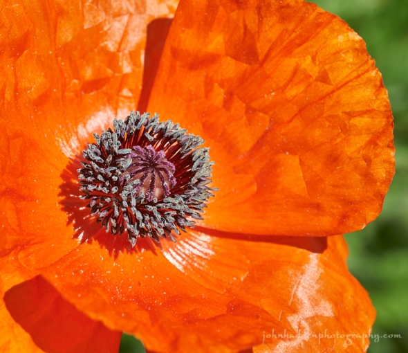
A poppy popping in our back garden
Morning Observation:
This morning in Huntington at 8:40AM it’s currently 67 degrees under mostly clear skies. Winds are calm. Relative humidity is 82%, dewpoint 62, barometric pressure 30.08” and rising slowly. Yesterday’s high was 81, and the overnight low was 49.
Forecast:
Scattered clouds and warm temperatures rising well into the upper 80s will prevail today. Dewpoints will increase this evening and overnight, making for a muggy night. The hot and humid conditions will continue right into Monday, which may be a few degrees hotter than today. Scattered showers and
thunderstorms will impact the region from late tonight through Monday evening as a slow moving cold front crosses the region. Any showers that develop will have the potential to produce heavy rainfall with some isolated gusty winds. Cooler and drier air will follow behind the cold front and bringing more comfortable weather through the middle of the week.
We’ll see mostly sunny skies today with a high near 88 and calm winds becoming southwesterly 5 to 8 mph in the morning. Tonight should be mostly cloudy with a low around 68 and south winds 9 to 11 mph.
Monday showers and thunderstorms are likely mainly after 1:00PM. Some of the storms could produce gusty winds and heavy rain. It’ll be partly sunny, humid, and hot with a high near 90 and southwest winds at 11 to 15 mph. Chance of precipitation is 70% with rainfall amounts between a quarter and half of an inch possible. Monday night showers and thunderstorms are likely before 1:00AM, then a chance of showers. Some of the storms could produce gusty winds and heavy rain. Lows will be around 62 with west winds 5 to 9 mph becoming light and variable after midnight. Chance of precipitation is 80% with rainfall amounts between a half and three quarters of an inch possible.
Tuesday’s looking mostly sunny with a high near 75 and northwest winds around 10 mph. Tuesday night should be mostly clear with a low around 53 and light and variable winds.
Almanac:
Last year on this date we had a high of 55 and a low of 39. We picked up 0.11″ of rain.
Burlington averages for this date are a high of 77 and lows of 56.
The record high was 96°F in 1994.
The record low was 42°F in 1925.
Sky Notes:
Sunrise: 5:08AM
Sunset: 8:39PM
Length of Visible Light: 16h 44m
Length of Day: 15h 31m
Tomorrow will be 0 minutes 15 seconds longer
The Moon is a waxing crescent, 4 days old with 17% illumination.
Moonrise: 9:28AM
No Moonset
About Today’s Photo:
We have a spreading host of poppies in our back garden that have made their brief and vibrant appearance. This photo was taken a couple days ago, and already most of the blooms have gone bye. I like how this photo shows the crinkled nature of the petals.
Nikon D600, Sigma 105mm macro lens, ISO 400, f/13, 1/250″ exposure.
Saturday, June 16, 2018


Corn rows create topo lines off of Shaker Mountain Road
Morning Observation:
This morning in Huntington at 8:25AM it’s currently 64 degrees under mostly sunny skies. Winds are calm. Relative humidity is 86%, dewpoint 60, barometric pressure 30.01” and steady. We picked up 0.02” of rain in the past 24hrs. Yesterday’s high was 74, and the overnight low was 46.
Forecast:
High pressure will continue to build across the region through the first half of the weekend bringing mostly sunny skies and above normal temperatures and increasing humidity. Sunday will be very warm with highs in the mid to upper 80s. Monday will be very muggy and perhaps even a few degrees warmer. A slow moving cold front will move in Sunday night into Monday bringing chances for showers and thunderstorms overnight Sunday night through Monday and lingering into early Tuesday. Cooler and drier air will return after the passage of the front.
We’ll see mostly sunny skies today with a high near 82 and light and variable winds becoming northwesterly 5 to 8 mph in the morning. Tonight should be partly cloudy with a low around 57 and light and variable winds.
Sunday should be sunny and warm with a high near 88 and calm winds becoming southwesterly 5 to 9 mph in the morning. Sunday night should be partly cloudy with a 30% chance of showers. Lows will be around 70 with south winds at 7 to 9 mph. Precipitation amounts of less than a tenth of an inch are possible.
Monday will bring a chance of showers early, with showers and thunderstorms becoming likely after 8:00AM. Some of the storms could produce gusty winds and heavy rain. Highs will be near 88 with south winds around 14 mph. Chance of precipitation is 60% with rainfall amounts between a quarter and half of an inch possible. Monday night showers and thunderstorms are likely before 1:00AM, then a chance of showers between later. Some of the storms could produce gusty winds and heavy rain. Lows will be around 62 with west winds at 3 to 8 mph. Chance of precipitation is 70% with rainfall amounts between a quarter and half of an inch possible.
Almanac:
Last year on this date we had a high of 67 and a low of 56. We picked up 0.32″ of rain.
Burlington averages for this date are a high of 77 and lows of 56.
The record high was 94°F in 1891.
The record low was 37°F in 1961.
Sky Notes:
Sunrise: 5:08AM
Sunset: 8:39PM
Length of Visible Light: 16h 44m
Length of Day: 15h 30m
Tomorrow will be 0 minutes 19 seconds longer
The Moon is a waxing crescent, 2.9 days old with 9% illumination.
Moonrise: 8:15AM
Moonset: 11:22PM
About Today’s Photo:
Yesterday’s breaking clouds allowed for splashes of sunshine across the young corn rows along Shaker Mountain Road. Following the rise and fall of the land, the rows remind me of topographical lines on a map.
Panasonic GX8, Lumix 14-140mm lens @ 34mm, ISO 400, f/18, 1/400″ exposure.
Friday, June 15, 2018

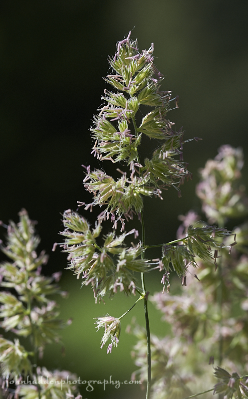
Bluegrass flowering in our front field
Morning Observation:
This morning in Huntington at 8:00AM it’s currently 51 degrees and drizzling a bit under overcast skies. Winds are calm. Relative humidity is 94%, dewpoint 49, barometric pressure 29.97” and rising slowly. We picked up 0.18” of rain in the past 24hrs. Yesterday’s high was 65, and the overnight low was 51.
Forecast:
An upper level shortwave trough is currently sliding southward across the international border bringing morning showers across the region. High pressure will build into the North Country today, however, bringing
mostly sunny skies and highs in the lower 70s by this afternoon. Dry weather and warming temperatures will continue into the weekend, with Sunday’s highs reaching well into the 80s along with an increase in humidity through the weekend. This increasing moisture combined with a slow
moving frontal system will result in the potential for showers and thunderstorms Sunday night into Monday.
Morning showers will give way to partly sunny skies by this afternoon with a high near 72 and northwest winds 5 to 10 mph. Tonight should be mostly clear, with a low around 52 and light and variable winds.
Saturday should be sunny with a high near 83 and light and variable winds becoming westerly 5 to 10 mph in the morning. Saturday night should be partly cloudy with a low around 58 and light and variable winds.
Sunday’s looking mostly sunny with a high near 88 and south winds 3 to 7 mph. Sunday night showers and thunderstorms are likely, mainly after 11:00pm. Some of the storms could produce heavy rainfall. It’ll be mostly cloudy with a low around 69 and south winds around 7 mph. Chance of precipitation is 60% with rainfall amounts between a quarter and half of an inch possible.
Almanac:
Last year on this date we had a high of 80 and a low of 39.
Burlington averages for this date are a high of 76 and lows of 55.
The record high was 97°F in 1988.
The record low was 41°F in 1923.
Sky Notes:
Sunrise: 5:08AM
Sunset: 8:38PM
Length of Visible Light: 16h 43m
Length of Day: 15h 30m
Tomorrow will be 0 minutes 23 seconds longer
The Moon is a waxing crescent, 1.7 days old with 3.3% illumination.
Moonrise: 7:06AM
Moonset: 10:32PM
About Today’s Photo:
Ah, the ripening grain… Bluegrass is flowering in our front field. It’s tiny dangling flowerettes often get overlooked, but they’re quite lovely.
Nikon D600, Sigma 105mm macro lens, ISO 400, f/8, 1/640″ exposure.
Thursday, June 14, 2018

Reed canarygrass setting seeds in our front field.
Morning Observation:
This morning in Huntington at 7:45AM it’s currently 58 degrees under overcast skies. Winds are calm. Relative humidity is 96%, dewpoint 57, barometric pressure 29.58” and steady. We picked up 0.15” of rain overnight. Yesterday’s high was 81, and the overnight low was 57.
Forecast:
Clouds and scattered showers will linger over the region today and into
tonight as upper low pressure spins by just to our north. Temperatures will be on the cool side with highs only in the 60s most spots. We’ll see gradual clearing later tonight as high pressure begins to build into the region on Friday bringing mostly sunny skies and highs around 70. Dry conditions and warming temperatures will continue into the weekend.
We’ll see scattered showers and cloudy skies today with a high near 62 and west winds 13 to 15 mph. Chance of precipitation is 50% with precipitation amounts between a tenth and quarter of an inch possible. Tonight should be cloudy with a 50% chance of showers. Lows will be around 49 with northwest wind 6 to 9 mph. Precipitation amounts of less than a tenth of an inch possible.
Friday should start out mostly cloudy, then gradually becoming sunny with a high near 72 and northwest winds 6 to 9 mph. Friday night should be clear with a low around 51 and northwest winds around 5 mph becoming calm in the evening.
Saturday’s looking sunny with a high near 82 and light and variable winds becoming northwesterlyt 5 to 9 mph in the morning. Saturday night should be mostly clear with a low around 57 and calm winds.
Almanac:
Last year on this date we had a high of 69 and a low of 42. We picked up 0.01″ of rain.
Burlington averages for this date are a high of 76 and lows of 55.
The record high was 94°F in 1988.
The record low was 36°F in 1912.
Sky Notes:
Sunrise: 5:08AM
Sunset: 8:38PM
Length of Visible Light: 16h 43m
Length of Day: 15h 29m
Tomorrow will be 0 minutes 28 seconds longer
The Moon is a waxing crescent, 0.5 days old with 0.3% illumination.
Moonrise: 6:04AM
Moonset: 9:34PM
About Today’s Photo:
With farmers bringing in their first cuts of hay, grasses are doing well in our front field. Reed canarygrass is common to Vermont with nicely compact seedheads. I like the subtle reddish tinge.
Nikon D600, Sigma 105mm macro lens, ISO 400, f/4.5, 1/4000″ exposure.
Wednesday, June 13, 2018

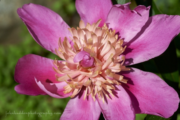
A burst of color and form in our back garden
Morning Observation:
This morning in Huntington at 7:20AM it’s currently a balmy 66 degrees under clear skies. Winds are out of the south at 0-4 mph. Relative humidity is 69%, dewpoint 56, barometric pressure 29.86” and falling slowly. Yesterday’s high was 81, and the overnight low was 53. Looking forward to some rain…
Forecast:
A strong upper level trough of low pressure and its associated cold front will move out of the Great Lakes today and into our region later today and into tonight. We’ll see some clouds and showers out ahead of this system with the threat of showers and some thunderstorms increasing over the area as it moves in later in the day. The best chance for any storms will be over northern New York, and any of these storms could produce strong and gusty winds. Showers will linger across the region tonight and into Thursday especially in the mountains. Below normal temperatures are expected on Thursday, but high pressure will begin building in Friday kicking off a warming and drying trend that will hold through the weekend.
We’ll see increasing clouds today with a high near 79 and south winds 6 to 10 mph. Showers should begin to move in mainly after 1:00PM with precipitation amounts of less than a tenth of an inch possible. Chance of showers is 80%. Tonight should be mostly cloudy with scattered showers and thunderstorms. lows will be around 58 and south wind 10 to 13 mph gusting as high as 28 mph. Chance of showers is 80% with precipitation amounts between a tenth and quarter of an inch possible.
Thursday should be mostly cloudy and showery with a high near 65 and northwest wind around 11 mph. Chance of rain is 80% with precipitation amounts between a tenth and quarter of an inch possible. Thursday night should be mostly cloudy with a 60% chance of showers. Lows will be around 46 with north winds 6 to 9 mph. Precipitation amounts of less than a tenth of an inch are possible.
Friday’s looking mostly sunny with a high near 74 and northwest winds 5 to 9 mph. Friday night should be mostly clear with a low around 51 and northwest winds around 5 mph becoming calm in the evening.
Almanac:
Last year on this date we had a high of 83 and a low of 51.
Burlington averages for this date are a high of 76 and lows of 55.
The record high was 94°F in 1949.
The record low was 40°F in 1923.
Sky Notes:
Sunrise: 5:09AM
Sunset: 8:39PM
Length of Visible Light: 16h 43m
Length of Day: 15h 30m
Tomorrow will be 0 minutes 32 seconds longer
The Moon is new 28.9 days old with 0.4% illumination.
Moonrises: 5:11AM
Moonset: 8:28PM
About Today’s Photo:
Peonies are starting to bloom in several locations on our property. We have a variety of diffent colors and forms. This blossom has an interested compound form of larger and smaller petals. Looking up the flowers on Wikipedia yields quite a bit of interesting information about the plant and its long and storied use as a medical plant and food additive especially in Asian cultures.
Nikon D600, Sigma 105mm macro lens, ISO 400, f/13, 1/800″ exposure.
Tuesday, June 12, 2018

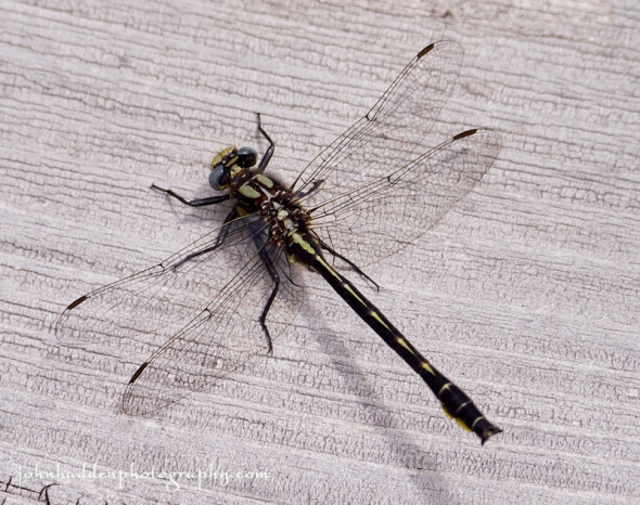
A skimmer dragonfly pauses briefly on our dock
Morning Observation:
This morning in Huntington at 7:40AM it’s currently 57 degrees under mostly sunny skies. Winds are calm. Winds are calm. Relative humidity is 87%, dewpoint 53, barometric pressure 30.12” and steady. Yesterday’s high was 73, and the overnight low was 40.
Forecast:
High pressure moving to our east today will deliver one more day of sunny skies. A south to southwest air flow will help to bump up temperatures into the upper 70s and low 80s today. Low pressure and an associated cold front moving out of the Great Lakes Wednesday will bring showers and perhaps some thunderstorms in the afternoon and evening. The front will exit the region late Wednesday night bringing most showers to an end. Cooler temperatures and the threat of more showers is expected for Thursday as a weaker secondary cold front moves through. High preswure and warming temperatures will build in Friday and continue right into the weekend.
We’ll see mostly sunny skies today with a high near 82 and southwest winds 6 to 10 mph. Tonight should be mostly clear with a low around 60 and southwest wind around 9 mph.
Wednesday should bring showers with thunderstorms possible after 2:00PM. It’ll be partly sunny with a high near 79 and south winds 7 to 9 mph gusting to 20 mph. Chance of precipitation is 40% with rainfall amounts between a tenth and quarter of an inch with higher amounts possible in thunderstorms. Wednesday night showers are likely, mainly before 9:00PM. It’ll be mostly cloudy with a low around 58 and southwest winds 11 to 13 mph. Chance of precipitation is 60% with precipitation amounts between a quarter and half of an inch possible.
Thursday’s looking mostly cloudy with a high near 67 and northwest wind around 13 mph. There’s a 40% chance of showers midday into the afternoon with precipitation amounts of less than a tenth of an inch possible.
Thursday night should be mostly cloudy with a low around 47 and northwest wind 5 to 8 mph becoming calm after midnight. There’s a 40% chance of showers before 2:00AM with precipitation amounts of less than a tenth of an inch possible.
Almanac:
Last year on this date we had a high of 90 and a low of 61.
Burlington averages for this date are a high of 75°F and a low of 54.
The record high was 94°F in 2017 (we had a high of 90).
The record low was 36°F in 1906.
Sky Notes:
Sunrise: 5:08AM
Sunset: 8:37PM
Length of Visible Light: 16h 41m
Length of Day: 15h 28m
Tomorrow will be 0 minutes 36 seconds longer
The Moon is a waning crescent, 27.8 days old with 3% illumination.
Moonrise: 4:25AM
Moonset: 7:15PM
About Today’s Photo:
There are numerous tiny and delicate damselflies active around our pond right now, but not many of the larger dragonfly species. This skimmer (?) was the exception. It took a brief break from its patrol to let me snap a shot of it.
Panasonic GX8, Lumix 100-300mm lens @ 300mm, ISO 800, f/8, 1/1000″ exposure.
Monday, June 11, 2018


A female eastern tiger swallowtail sipping from comfry
Morning Observation:
This morning in Huntington at 7:15AM it’s currently 44 degrees under clear skies. Winds are calm. Relative humidity its 98%, dewpoint 44, barometric pressure 30.09” and steady. Yesterday’s high was 70, and the overnight low got down to 36.
Forecast:
The high pressure that’s been delivering our clear, cool nights will be shifting southeastward towards the Mid-Atlantic Coast tonight putting us in a southwesterly air flow and setting up a warming trend through Tuesday. Low pressure and a weak cold front will bring some rain showers and possibly a few thunderstorms Wednesday. Lingering showers will remain through the end of the work week as the weather pattern remains unsettled, but the weekend looks dry and warm as high pressure returns.
We’ll see sunny skies today with a high near 72 and light and variable winds becoming northwesterly around 6 mph in the morning. Tonight should be mostly clear with a low around 48 and calm winds becoming southerly around 5 mph after midnight.
Tuesday should be sunny with a high near 81 and southwest winds 8 to 13 mph. Tuesday night should be partly cloudy with a low around 61 and south wind around 9 mph.
Wednesday should be partly sunny early with a high near 81 and south winds around 8 mph. Showers should develop around mid-day with precipitation amounts between a tenth and quarter of an inch possible. Chance of rain is 50%. Wednesday night should be cloudy with a low around 59 and west winds around 7 mph. Precipitation amounts between a tenth and quarter of an inch possible. Chance of rain is 50%.
Almanac:
Last year on this date we had a high of 91 and a low of 58.
Burlington averages for this date are a high of 75 and lows of 54.
The record high was 95°F in 2017 (we had the aforementioned high of 91).
The record low was 35°F in 1972.
Sky Notes:
Sunrise: 5:08AM
Sunset: 8:36PM
Length of Visible Light: 16h 40m
Length of Day: 15h 28m
Tomorrow will be 0 minutes 40 seconds longer
The Moon is a waning crescent, 26.7 days old with 9% illumination.
Moonrise: 3:48AM
Moonset: 6:01PM
About Today’s Photo:
The eastern tiger swallowtails have been in abundance this season. I’ve seen them all over the place and finally managed to get a decent shot of one. This female (noticeable because of the distinct blue bands along the base of its wings which males lack) was enjoying the “volunteer” comfry that’s growing near our woodshed.
Nikon D600, Sigma 105mm macro lens, ISO 400, f/8, 1/640″ exposure.
Sunday, June 10, 2018

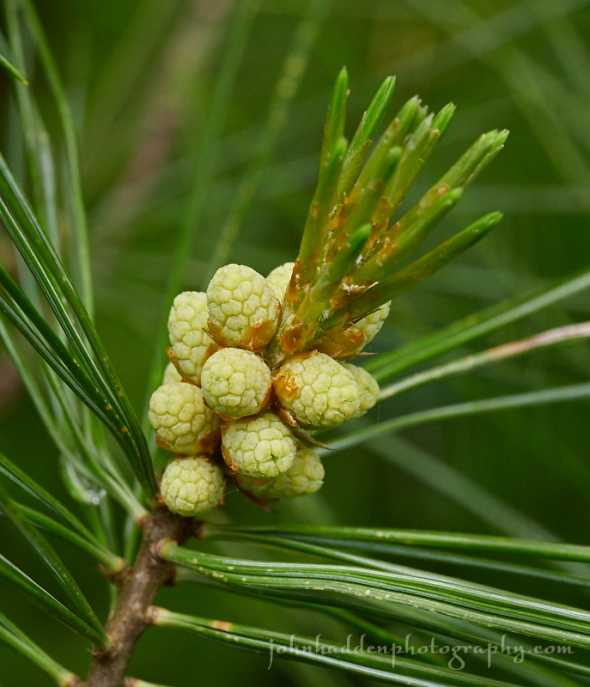
Tiny baby pinecones on a white pine
Morning Observation:
This morning in Huntington at 7:25AM it’s currently 49 degrees under clear skies. Winds are calm. Relative humidity is 93%, dewpoint 47, barometric pressure 30.12” and steady. Yesterday’s high was 74, and the overnight low got down to 38.
Forecast:
High pressure remains in control over the region and will deliver fair weather and a warming temperature trend through Tuesday. Low pressure and an associated cold front heading our way from the Great Lakes on Wednesday will bring our next chance of showers along with a slight chance of thunderstorms.
We’ll see sunny skies today with a high near 70 and northwest winds 5 to 9 mph. Tonight should be mostly clear with a low around 47 and north winds around 5 mph becoming light and variable in the evening.
Monday should be sunny with a high near 76 and light and variable winds.
Monday night should be mostly clear with a low around 52 and calm winds becoming southerly around 5 mph after midnight.
Tuesday’s looking sunny and warmer with a high near 80 and southwest winds 6 to 9 mph. Tuesday night should bring a 30% chance of showers after late. It’ll be partly cloudy with a low around 60 and south winds around 7 mph.
Almanac:
Last year on this date we had a high of 80 and a low of 48. We picked up 0.04″ of rain.
Burlington averages for this date are a high of 75 and lows of 54.
The record high was 93°F in 1974.
The record low was 34°F in 1912.
Sky Notes:
Sunrise: 5:09AM
Sunset: 8:36PM
Length of Visible Light: 16h 40m
Length of Day: 15h 27m
Tomorrow will be 0 minutes 44 seconds longer
The Moon is a waning cresent, 25.6 days old with 16.5% illumination.
Moonrise: 3:15AM
Moonset: 4:49PM
About Today’s Photo:
The pinecone crop is coming in on some of the white pines flanking the west side of our property. These tiny “baby” cones were no more than a 3-4mm long.
Panasonic GX8, Olympus 60mm macro lens, ISO 800, f/8, 1/200″ exposure.
Saturday, June 9, 2018

Bachelor Button blooming in our side garden
Morning Observation:
This morning in Huntington at 7:50AM it’s currently 55 degrees under mostly sunny skies. Winds are calm. Relative humidity its 98%, dewpoint 54, barometric pressure 30.14” and steady. Yesterday’s high was 73, and the overnight low was 42.
Forecast:
We’ve got a lovely weekend on tap courtesy of high pressure currently parked over the region. We’ll see dry, sunny days with highs in the upper 60s to mid 70s expected. Temperatures will warm for the first half of the work week bumping up into the upper 70s and low 80s by mid week. Our next
chance of rain comes Tuesday night through Wednesday as low pressure and an associated cold front push through.
We’ll see sunny skies today with a high near 74 and light and variable winds becoming northwesterly 10 to 15 mph in the morning. Tonight should be mostly clear with a low around 44 and north wind around 6 mph becoming calm in the evening.
Sunday should be sunny with a high near 70 and northwest winds 5 to 9 mph.
Sunday night should be mostly clear with a low around 47 and north winds around 5 mph becoming light and variable in the evening.
Monday’s looking sunny with a high near 76 and ight and variable winds.
Monday night should be mostly clear with a low around 52 and calm winds becoming southerly around 5 mph after midnight.
Almanac:
Last year on this date we had a high of 74 and a low of 42.
Burlington averages for this date are a high of 75 and lows of 54.
The record high was 93°F in 1933.
The record low was 37°F in 1983.
Sky Notes:
Sunrise: 5:09AM
Sunset: 8:35PM
Length of Visible Light: 16h 39m
Length of Day: 15h 26m
Tomorrow will be 0 minutes 48 seconds longer
The Moon is a waning cresent, 24.6 days old with 25% illumination.
Moonrise: 2:46AM
Moonset: 3:40PM
About Today’s Photo:
I was struck by the lovely lacy symmetry of this bachelor button blossom.
Panasonic GX8, Olympus 60mm macro lens, ISO 800, f/2.8, 1/320″ exposure.
Friday, June 8, 2018


A bumble bee makes a stop at a bearded iris
Morning Observation:
This morning in Huntington at 7:15AM it’s currently 57 degrees under cloudy skies. Winds are calm. Relative humidity is 97%, dewpoint 56, barometric pressure 30.13” and rising rapidly. We picked up a 0.01” trace of rain overnight. Yesterday’s high was 71, and the overnight low was 53.
Forecast:
A weak cold front passing through northern New York and Vermont early this morning will bring a northwesterly wind shift allowing skies to clear during the mid to late morning hours. Low humidity and sunshine are expected this afternoon with temperatures reaching the upper 60s to mid 70s. Quiet weather and seasonable temperatures will continue through this weekend. The next chance for widespread precipitation is not expected
until the middle of next week.
We’ll see mostly cloudy skies through mid morning, then gradual clearing with a high near 75 and northwest winds at 7 to 10 mph. Tonight should be mostly clear with a low around 49 and calm winds becoming southerly around 5 mph after midnight.
Saturday should be mostly sunny with a high near 76 and light west winds becoming northwesterly at 6 to 11 mph in the morning. Saturday night should be mostly clear with a low around 45 and north winds around 6 mph, becoming calm in the evening.
Sunday’s looing sunny with a high near 70 and north winds at 3 to 8 mph.
Sunday night should be mostly clear with a low around 46 and light and variable winds.
Almanac:
Last year on this date we had a high of 82 and a low of 45.
Burlington averages for this date are a high of 74 and low of 53.
The record high was 91°F in 1984.
The record low was 36°F in 1960.
Sky Notes:
Sunrise: 5:09AM
Sunset: 8:35PM
Length of Visible Light: 16h 38m
Length of Day: 15h 25m
Tomorrow will be 0 minutes 52 seconds longer
The Moon is a waning crescent, 23.6 days old with 35% illumination.
Moonrise: 2:18AM
Moonset: 2:32PM
About Today’s Photo:
We have several clumps of beared iris around our place. These relatively early bloomers have a strong, sweet scent that reminds us of grape bubblegum. Quite intoxicating! It seems this bumblebee finds them attractive too!
Panasonic GX8, Olympus 60mm macro lens, ISO 800, f/8, 1/400″ exposure.
Thursday, June 7, 2018


An ant on a peony?
Morning Observation:
This morning in Huntington at 7:35AM it’s currently 55 degrees under cloudy skies. Winds are calm. Relative humidity is 98%, dewpoint 54, barometric pressure 30.04” and rising slowly. We picked up 0.04” of rain in the past 24hrs. Yesterday’s high was 65, and the overnight low was 47.
Forecast:
Relatively tranquil conditions are expected today through the upcoming weekend. A weak upper level trough passing across southern Quebec will bring cloudy conditions today and a brief sprinkle or isolated shower across northern Vermont and far northern New York today and tonight. Dry and seasonable conditions will continue through the upcoming weekend with low humidity and daytime temperatures bumping into the low to mid 70s.
We’ll see partly sunny skies today with highs near 72 and southwest winds at 5 to 10 mph. There’s a 20% chance of showers this afternoon in northern areas along the Canadian border. Tonight should bring a slight chance of showers north. It’ll be mostly cloudy, with a low around 53 and south winds at 3 to 5 mph. Chance of precipitation is 20%.
Friday should be partly to mostly sunny with a high near 71 and northwest winds at 5 to 10 mph. Friday night should bring increasing clouds with a low around 52 and light and variable winds.
Saturday’s looking mostly sunny with a high near 72 and northwest winds at 6 to 9 mph. Saturday night should be mostly clear with a low around 47 and north winds around 5 mph becoming calm in the evening.
Almanac:
Last year on this date we had a high of 75 and a low of 39. We picked up 0.51″ of rain.
Burlington averages for this date are a high of 74 and lows of 53.
The record high was 94°F in 1999 (we had a high of 92).
The record low was 35°F in 1958.
Sky Notes:
Sunrise: 5:09AM
Sunset: 8:34PM
Length of Visible Light: 16h 37m
Length of Day: 15h 24m
Tomorrow will be 0 minutes 57 seconds longer
The Moon is a waning crescent, 22.6 days old with 44% illumination.
Moonrise: 1:52AM
Moonset: 1:28PM
About Today’s Photo:
Thoses of you who have peonies in your gardens might have noticed that the flower buds seem to have been overrun with ants. Infestation? Nope. The ants are actually a welcome guest. Peonies have a protective waxy coating on their buds that must be removed before they can flower. The ants provide the clean up crew as the wax is an attractive nutrient for them. A classic example of a symbiotic relationship!
Panasonic GX8, Olympus 60mm macro lens, ISO 800, f/11, 1/100″ exposure.
Wednesday, June 6, 2018

A pair of damselflies mating by the pond
Morning Observation:
This morning in Huntington at 7:10AM it’s currently a damp 51 degrees under overcast skies. Winds are calm. Relative humidity is 98%, dewpoint 51, barometric pressure 29.81” and rising slowly. We picked up 0.02” of rain in the past 24hrs. Yesterday’s high was 58, and the overnight low was 47.
Forecast:
The low that has been responsible for the damp, cool conditions of the past few days is finally exiting to our east. High pressure will build into the region allowing skies to become mostly sunny by later today. Temperatures will reach the mid to upper 60s this afternoon, and moderate into the 70s for Thursday through Sunday. An upper level disturbance moving eastward along the International Border may bring a few light showers across northern areas on Thursday afternoon, but but we shouldn’t see much in the chance of showers through the weekend.
Morning clouds and fog will give way to partly sunny skies today, with a high near 67 and northwest wind 3 to 7 mph. Tonight should be partly cloudy with a low around 50 and light and variable winds.
Thursday should be partly sunny with a slight chance of late afternoon showers north. Highs will be near 73 with southwest wind 7 to 11 mph. Chance of rain is 20%. Thursday night should be mostly cloudy with a low around 55 and southwest wind 3 to 6 mph.
Friday’s looking mostly sunny with a high near 72 and northwest wind 5 to 7 mph. Friday night should be mostly clear with a low around 50 and northwest wind around 5 mph becoming calm in the evening.
Almanac:
Last year on this date we had a high of 55 and a low of 47. We picked up 0.19″ of rain.
Burlington averages for this date are a high of 74 and lows of 53.
The record high was 94°F in 1925.
The record low was 37°F in 1964.
Sky Notes:
Sunrise: 5:10AM
Sunset: 8:33PM
Length of Visible Light: 16h 35m
Length of Day: 15h 23m
Tomorrow will be 1 minutes 0 seconds longer
The Moon is in its last quarter, 21.7 days old with 54% illumination.
Moonrise: 1:24AM
Moonset: 12:25PM
About Today’s Photo:
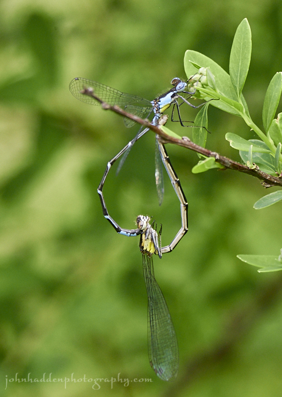
The damselflies are out and about hunting by our pond. There are several different species active now. I spotted this pair of bluets (?) mating on a rose bush right by the water’s edge.
Panasonic GX8, Lumix 100-300mm lens @ 300mm, ISO 1250, f/10, 1/160″ exposure.
Tuesday, June 5, 2018

Iris in bloom on our pond bank
Morning Observation:
This morning in Huntington at 8:40AM it’s currently 54 degrees under overcast skies. Winds are calm. Relative humidity is 82%, dewpoint 49, barometric pressure 29.61” and steady. We picked up 0.18” of rain in the past 24hrs. Yesterday’s high was 58, and the overnight low was 48.
Forecast:
Cool and damp conditions will persist for the next couple of day courtesy of a slow-moving upper low pressure system centered across southern
Quebec this morning. The best chance for showers will occur this afternoon into tonight, with daytime highs only in the upper 50s to lower 60s. We should see additional rainfall amounts of a tenth to a quarter inch late today into tonight. The low will shift east of the region Wednesday, bringing gradual clearing and slightly warmer conditions. Drier conditions are expected through the end of the week with daytime highs moderating back into the 70s Thursday through Sunday.
We’ll see cloudy skies today with a few showers developing during the afternoon. Highs will be around 61F with WNW winds at 5 to 10 mph. Chance of rain is 30%. Tonight should bring showers early with cloudy skies overnight. Lows will be around 48F with light and variable winds. Chance of rain is 50%.
Wednesday should bring a shower or two early with partly cloudy skies in the afternoon. Highs will be around 66F with NW winds at 5 to 10 mph. Chance of rain is 30%. Wednesday night should be mostly clear during the evening followed by cloudy skies overnight. Lows will be around 51F with light and variable winds.
Thursday’s looking overcast with a slight chance of a rain shower as a weak low passes well north of the Canadian border. Highs will be around 69F witih SW winds at 5 to 10 mph. Thursday night should be cloudy with lows around 55F and WSW winds at 5 to 10 mph.
Almanac:
Last year on this date we had a high of 59 and a low of 52. We picked up 0.04″ of rain.
Burlington averages for this date are a high of 73 and lows of 52.
The record high was 92°F in 1919.
The record low was 34°F in 1910.
Sky Notes:
Sunrise: 5:10AM
Sunset: 8:33PM
Length of Visible Light: 16h 34m
Length of Day: 15h 22m
Tomorrow will be 1 minutes 4 seconds longer
The Moon is waning gibbous, 20.8 days old with 63% illumination.
Moonrise: 12:55AM
Moonset: 11:24AM
About Today’s Photo:
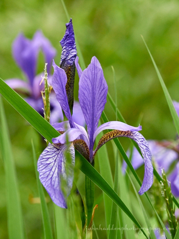
It’s hard to beat the elegant beauty of irises blooming. This is prime time of year for the several varieties we have around our property.
Panasonic GX8, Lumix 14-140mm lens @ 140mm, ISO 1250, f/10, 1/250″ exposure.
Monday, June 4, 2018

A flower fly works buckthorn blossoms in our front field
Morning Observation:
This morning in Huntington at 7:55AM it’s currently 47 degrees and raining lightly under overcast skies. Winds are out of the south at 4-6 mph. Relative humidity is 87%, dewpoint 44, barometric pressure 29.79” and steady. We picked up 0.10” of rain overnight. Yesterday’s high was 76, and the overnight low was 46.
Forecast:
A slow moving trough of low pressure over the Great Lakes and James Bay will deliver cool and unsettled weather across the region for the beginning of week. A steady rain this morning will taper off to scattered showers
this afternoon with temperatures mainly in the 50s to near 60. More showers are expected on Tuesday and Wednesday with continued below normal temperatures. Drier and warmer conditions will return toward the end of the
week.
We’ll see light rain early then cloudy skies with showers this afternoon. Highs will be only around 55F with SSE winds at 10 to 20 mph. Chance of rain is 90%. Tonight should be mostly cloudy with periods of light rain early. Lows will be around 47F with south winds at 10 to 15 mph. Chance of rain is 70%.
Tuesday should be cloudy early with a few showers developing later in the day. Highs will be around 61F with light and variable winds. Chance of rain is 30%. Tuesday night should bring showers in the evening, then cloudy skies overnight. Lows will be around 48F with light and variable winds. Chance of rain is 30%.
Wednesday should bring showers in the morning, then partly cloudy skies in the afternoon. Highs will be around 65F with NNW winds at 5 to 10 mph. Chance of rain is 40%. Wednesday night should be partly cloudy with lows around 48F and light and variable winds.
Almanac:
Last year on this date we had a high of 70 and a low of 45. We picked up 0.17″ of rain.
Burlington averages for this date are a high of 73 and lows of 52.
The record high was 92°F in 1919.
The record low was 34°F in 1910.
Sky Notes:
Sunrise: 5:10AM
Sunset: 8:32PM
Length of Visible Light: 16h 33m
Length of Day: 15h 21m
Tomorrow will be 1 minutes 8 seconds longer
The Moon is waning gibbous, 20 days old with 73% illumination.
Moonrise: 12:22AM
Moonset: 10:24AM
About Today’s Photo:
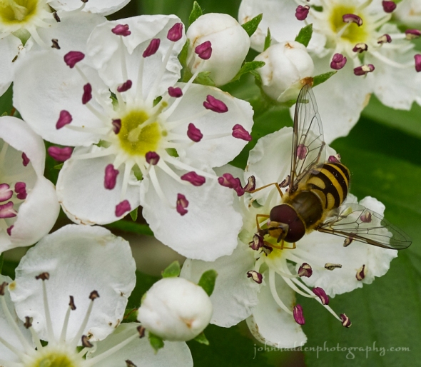
The buckthorn at the edge of our front field is in full bloom right now. It’s someewhat malodorous blossoms are attracting a wide range of pollinators including this flower fly.
Panasonic GX8, Olympus 60mm macro lens, ISO 800, f/11, 1/200″ exposure.
