Saturday, September 27, 2014

Staghorn sumac against a clear blue sky
Morning Observation:
This morning in Huntington at 7:20AM it’s currently 48 degrees under clear skies. Winds are calm. Relative humidity is 98%, dewpoint 48, barometric pressure 30.23″. Yesterday’s high was 76, and the overnight low was 48.
Forecast:
High pressure is firmly entrenched across the northeastern US, and will continue to serve up delightful weather straight through the weekend with clear skies and above normal temperatures. We’ll see sunny skies today with highs in the upper 70s and light and variable winds. Tonight should be clear with lows in the mid 50s and light and variable winds.
Sunday should be sunny with highs in the upper 70s to 80 (some records may be broken!) with light and variable winds. Sunday night should be mostly clear with lows in the mid 50s and light and variable winds.
Monday’s looking partly sunny with highs around 70 and light and variable winds. Monday night should be mostly cloudy with lows in the upper 40s.
Almanac:
Last year on this date we had a high of 65 and a low of 44.
Burlington norms for this date are highs of 65 and lows of 46.
The record high was 83°F in 1920.
The record low was 27°F in 1947.
Sky Notes:
Sunrise: 6:45 AM EDT
Sunset: 6:40 PM EDT
Length of Visible Light: 12h 52m
Length of Day: 11h 55m
Tomorrow will be 3m 2s shorter.
The Moon is a waxing crescent, 3d 5h old with 10% illumination.
Moonrise: 10:04 AM EDT
Moonset: 8:30 PM EDT
About Today’s Photo:
Gotta love the vibrancy staghorn sumac this time of year. It’s often one of the first to pop into its fall colors.
Nikon D600, Nikon 50mm lens, ISO 125, f/2.8, 1/2000″ exposure.
See y’all in a week!
Friday, September 26, 2014

Corn dries and early color descends down in Hanksville
Morning Observation:
This morning in Huntington at 6:45AM it’s currently 45 degrees under clear skies. Winds are calm. Relative humidity is 98%, dewpoint 45, barometric pressure 30.27”. Yesterday’s high was 70, and the overnight low was 45.
Forecast:
A large high pressure system will become established over the northeastern US and persist right through the weekend bringing dry, sunny conditions and temperatures above seasonal norms. We’ll see sunny skies with highs in the mid 70s today with light and variable winds. Tonight should be clear with lows in the lower 50s and light and variable winds.
Saturday should be sunny with highs in the mid 70s and light and variable winds. Saturday night should be clear with lows in the mid 50s and light and variable winds.
Sunday’s looking sunny and warmer with highs in the upper 70s and light and variable winds. Sunday night should be partly cloudy with lows in the lower 50s.
Almanac:
Last year on this date we had a high of 61 and a low of 35.
Burlington norms for this date are highs of 66 and lows of 47.
The record high was 84°F in 1920.
The record low was 27°F in 1947.
Sky Notes:
Sunrise: 6:43 AM EDT
Sunset: 6:42 PM EDT
Length of Visible Light: 12h 56m
Length of Day: 11h 58m
Tomorrow will be 3m 2s shorter.
The Moon is a waxing crescent, 2s 4h old with 5% illumination.
Moonrise: 9:02 AM EDT
Moonset: 7:54 PM EDT
About Today’s Photo:
The cornfields along the Main Road near the Alpaca Farm are just about ready for chopping, and the fall colors are coming in quickly to the hillsides across the Huntington River.
Nikon D600, Nikon 24-120mm lens @ 24mm, ISO 800, f/18, 1/400″ exposure.
Thursday, September 25, 2014

Wild grapes and sumac in the morning sun
Morning Observation:
This morning in Huntington at 7:00AM it’s currently 45 degrees under partly cloudy skies. Winds are calm. Relative humidity is 98%, dewpoint 45, barometric pressure 30.47″. Yesterday’s high was 70, and the overnight low was 44.
Forecast:
A low pressure system will be moving up the eastern Seaboard today spreading high level clouds into the region, but we shouldn’t see any precipitation out of it. We’ll see mostly sunny skies with highs in the upper 60s and light and variable winds. Tonight should be clear with lows around 50 and light and variable winds.
High pressure will again build in Friday brining sunny skies and above normal temperatures with highs in the lower 70s and light and variable winds. Friday night should be clear with lows in the lower 50s and light and variable winds.
Saturday’s looking sunny and warm with Highs in the mid 70s and light and variable winds. Saturday night should be clear with lows in the lower 50s and highs in the upper 70s. At this point it looks like we’re in for an extended period of great fall weather heading clear through most of next week!
Almanac:
Last year on this date we had a high of 62 and a low of 38.
Burlington norms for this date are highs of 66 and lows of 47.
The record high was 85°F in 1891.
The record low was 28°F in 1963.
Sky Notes:
Sunrise: 6:42 AM EDT
Sunset: 6:43 PM EDT
Length of Visible Light: 12h 59m
Length of Day: 12h 01m
Tomorrow will be 3m 2s shorter.
The Moon is a waxing crescent, 1d 4h old with 1% illumination.
Moonrise: 8:01 AM EDT
Moonset: 7:21 PM EDT
About Today’s Photo:
I came across these wild grapes climbing the fiery red sumac along the Main Road near the Jubilee Farm barn (in the background) yesterday morning. They were a tad on the sour side!
Nikon D600, Nikon 50mm lens, ISO 125, f/3.5, 1/800″ exposure.
Wednesday, September 24, 2014

A bright red maple leaf on a mossy rock
Morning Observation:
This morning in Huntington at 6:55AM it’s currently 42 degrees under clear skies. Winds are calm. Relative humidity is 98%, dewpoint 41, barometric pressure 30.55” and rising rapidly. Yesterday’s high was 63, and the overnight low was 41.
Forecast:
With a large area of high pressure anchored over New England, we’ll see fair and dry weather and above average temperatures clear through the upcoming weekend. We’ll see sunny skies today with highs in the upper 60s and light and variable winds. Tonight should be clear with lows in the mid 40s and light and variable winds.
Thursday should be partly sunny with highs in the upper 60s and light and variable winds. Thursday night should be clear with lows in the upper 40s and light and variable winds.
Friday’s looking sunny with highs in the lower 70s and light and variable winds. Friday night should be clear with lows in the lower 50s.
Almanac:
Last year on this date we had a high of 60 and a low of 41.
Burlington norms for this date are highs of 67 and lows of 47.
The record high was 84°F in 1961.
The record low was 25°F in 1963.
Sky Notes:
Sunrise: 6:41 AM EDT
Sunset: 6:45 PM EDT
Length of Visible Light: 13h 02m
Length of Day: 12h 04m
Tomorrow will be 3m 3s shorter.
The Moon is new, 4 hours old with 0% illumination.
Moonrise: 7:01 AM EDT
Moonset: 6:52 PM EDT
About Today’s Photo:
As the colors begin to shift into high gear, I came across the solitary bright red sugar maple leaf up in the wood on mossy rock.
Nikon D600, Sigma 105mm macro lens, ISO 1250, f/8, 1/320″ exposure.
Tuesday, September 23, 2014

A wood fern fades from green to yellow
Morning Observation:
This morning in Huntington at 6:45AM it’s currently 44 degrees under overcast skies. Winds are calm. Relative humidity is 98%, dewpoint 44, barometric pressure 30.20” and rising. Yesterday’s high was 62, and the overnight low was 39.
Forecast:
An upper level trough across Quebec and northern New England will bring variable amounts of cloudiness across the region today with a few sprinkles possible across the mountains. We’ll see mostly cloudy skies with highs around 60 and light and variable winds becoming westerly around 10 mph this afternoon. Skies will clear out tonight as broad high pressure amplifies over the eastern US. Overnight lows will be in the lower 40s with light and variable winds.
Wednesday should be sunny and milder with highs in the upper 60s and light and variable winds. Wednesday night should be clear with lows in the mid 40s and light and variable winds.
Thursday’s looking sunny with highs in the upper 60s and light and variable winds. Thursday night should be clear with lows in the upper 40s.
Almanac:
Last year on this date we had a high of 49 and a low of 42. We picked up 0.11″ of rain.
Burlington norms for this date are highs of 67 and lows of 48.
The record high was 87°F in 1895.
The record low was 29°F in 1963.
Sky Notes:
Sunrise: 6:40 AM EDT
Sunset: 6:47 PM EDT
Length of Visible Light: 13h 05m
Length of Day: 12h 07m
Tomorrow will be 3m 2s shorter.
The Moon is a waning crescent, 28d 20h old with 1% illumination.
Moonrise: 6:01 AM EDT
Moonset: 6:24 PM EDT
About Today’s Photo:
The wood ferns are fading up in the woods across the road. I love the way the take on a bright lemon-lime color as they fade to white.
Nikon D600, Sigma 105mm macro lens, ISO 800, f/3.5, 1/60″ exposure.
Monday, September 22, 2014; the Autumnal Equinox

A forest of horsetails along the Winooski River
Happy Equinox!
Morning Observation:
This morning in Huntington at 6:30AM it’s currently 56 degrees under overcast skies. Winds are calm. Relative humidity is 96%, dewpoint 55, barometric pressure 29.58” and rising. We picked up 0.34” of rain overnight. Yesterday’s high was a summery 81, and the overnight low was 56.
Forecast:
The surface cold front which brought showers to the region overnight will shift east of the region today and andy scattered showers should taper off this morning. We’ll see mostly cloudy skies with a chance of showers this morning. It’ll be on the cool side again with highs only in the mid 50s and west winds 10 to 15 mph gusting up to 30 mph. Chance of rain is 50%. High pressure will begin moving in tonight bringing partly cloudy skies with lows in the upper 30s and west winds 10 to 15 mph.
Tuesday should be partly sunny with highs in the lower 60s and southwest winds around 10 mph, becoming westerly in the afternoon. Tuesday night should be mostly clear with lows in the lower 40s and north winds around 10 mph.
Wednesday’s looking sunny with highs in the mid 60s and light and variable winds. Wednesday night should be clear with lows in the mid 40s. At this point the trend is for gradually warmer and continued dry weather into next weekend.
Almanac:
Last year on this date we had a high of 62 and a low of 45. We picked up 0.67″ of rain.
Burlington norms for this date are highs of 68 and lows of 48.
The record high was 88°F in 1965.
The record low was 31°F in 1962.
Sky Notes:
Sunrise: 6:39 AM EDT
Sunset: 6:49 PM EDT
Length of Visible Light: 13h 08m
Length of Day: 12h 10m
Tomorrow will be 3m 2s shorter.
The Moon is a waning crescent, 27d 20h old with 3% illumination.
Moonrise: 5:02 AM EDT
Moonset: 5:57 PM EDT
The Autumnal Equinox occurs today at 10:29PM. Equinoxes, like solstices, occur twice a year—in March and September—and mark the time when the the earth’s axis (tilted at 23.5°) is near perpendicular with the sun’s rays as the earth orbits the sun. Consequently, we get a near-equal amount of night and day. You can read more about the equinox here. Astute observers (John I…) will note that the length of day reported above is not exactly 12 hours. This is because of two things: the first is that “sunrise” is defined as the moment that the leading edge of the sun first breaks an imaginary plane of the horizon, and “sunset” is the moment the upper edge of the sun disappears below the horizon. It takes some time for the entirety of the sun’s disc to travel below the horizon, hence more daylight. Also, refraction causes the sun’s upper edge to be visible from Earth several minutes before the edge actually reaches the horizon, and, conversely, after it sets. I hope that explains it! You can read more about it here.
About Today’s Photo:
Robin & I biked the Richmond River Trail along the Winooski River yesterday morning. We came across this enchanting horsetail forest down near the mouth of the Huntington River. Lovely!
Sony RX100m3, ISO 125, 1/30″ exposure.
Saturday, September 20, 2014

Frosted white asters in the front field yesterday morning.
Morning Observation:
This morning in Huntington at 7:50AM it’s currently a balmy 54 degrees under overcast skies. Wind are out of the southwest at 3-5 mph. Relative humidity is 82%, dewpoint 49, barometric pressure 30.19” and falling. Yesterday’s high was 59, and the overnight low was 38.
Forecast:
High pressure departing off the New England coast will bring mild, dry and gusty conditions to the region today. We’ll see mostly cloudy skies this morning, then partly sunny skies later in the day. Highs will be in the upper 60s with south winds 15 to 20 mph gusting up to 35 mph. Tonight should be partly cloudy and mild with lows in the upper 50s and south winds 10 to 15 mph gusting up to 30 mph.
Sunday should start out partly sunny with a chance of showers in the morning, then become mostly cloudy with showers likely and a slight chance of thunderstorms in the afternoon as a cold front and associated low pressure move in. Highs will be in the lower 70s with south winds 10 to 15 mph. Chance of rain is 70%. Sunday night should bring occasional showers. Lows will be in the mid 50s with south winds around 10 mph. Chance of rain is 90%.
Showers will linger into Monday with mostly cloudy skies and highs in the mid 50s with northwest winds around 10 mph. Chance of rain is 50%. Monday night should be partly cloudy with lows in the lower 40s.
Almanac:
Last year on this date we had a high of 79 and a low of 45.
Burlington norms for this date are highs of 69 and lows of 49.
The record high was 89°F in 1946.
The record low was 29°F in 1929.
Sky Notes:
Sunrise: 6:36 AM EDT
Sunset: 6:53 PM EDT
Length of Visible Light: 13h 14m
Length of Day: 12h 16m
Tomorrow will be 3m 3s shorter.
The Moon is a waning crescent, 25d 21h old with 12% illumination.
Moonrise: 3:07 AM EDT
Moonset: 5:00 PM EDT
About Today’s Photo:
Yesterday’s frost lay thick and heavy on the flat-topped white asters in our front field. They appear almost glass-like in the morning sun.
Nikon D600, Sigma 105mm macro lens, ISO 800, f/16, 1/200″ exposure.
Friday, September 19, 2014

A frosted dandelion on the volleyball court
Morning Observation:
This morning in Huntington at 6:15AM it’s currently a brisk 28 degrees under clear skies. Jupiter and the moon are shining brightly in the east. Winds are calm. Relative humidity is 97%, dewpoint 27, barometric pressure 30.36” and rising rapidly. We have a thorough coating of frost on the ground this morning. Yesterday’s high was 53, and the overnight low was 28.
Forecast:
This morning’s chilly and frosty start is courtesy of a large area of Canadian high pressure currently building into the region. We’ll see sunny skies today with below normal temperature with highs only in the mid 50s with light and variable winds. Tonight should be clear and not as cold with lows in the lower 40s and south winds 10 to 15 mph.
Temperatures will rebound somewhat on Saturday as the departing high puts us into a gusty southerly airflow. We’ll see partly sunny skies in the morning, then mostly cloudy skies later in the day. Highs will be in the mid 60s with south winds 15 to 20 mph gusting up to 30 mph. Saturday night should be mostly cloudy with lows in the upper 50s and south winds 15 to 20 mph gusting up to 30 mph.
A cold front and associated low pressure will cross the region Sunday bringing showers. Highs will be in the lower 70s with south winds 15 to 20 mph. Chance of rain is 70%. Showers will continue into Sunday night with lows in the upper 40s. Chance of rain is 60%.
Almanac:
Last year on this date we had a high of 76 and a low of 42.
Burlington norms for this date are highs of 69 and lows of 50.
The record high was 85°F in 1946.
The record low was 32°F in 1959.
Sky Notes:
Sunrise: 6:35 AM EDT
Sunset: 6:55 PM EDT
Length of Visible Light: 13h 17m
Length of Day: 12h 19m
Tomorrow will be 3m 2s shorter.
The Moon is a waning crescent, 24d 20h old with 20% illumination.
Moonrise: 2:10 AM EDT
Moonset: 4:28 PM EDT
About Today’s Photo:
I posted this shot on my photography blog yesterday, but couldn’t resist posting it here as well. (Sorry for the duplication for those of you who subscribe to both—and thanks if you do!) The fine crystals on the delicate “parachutes” are really striking.
Nikon D600, Sigma 105mm macro lens, ISO 1250, f/18, 1/60″ exposure.
Thursday, September 18, 2014
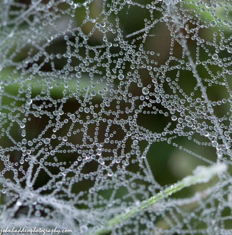
A spider web holds tiny frozen drops of dew
Morning Observation:
This morning in Huntington at 6:55AM it’s currently 50 degrees under overcast skies. Winds are calm. Relative humidity is 99%, dewpoint 50, barometric pressure 29.96” and rising. Yesterday’s high was 66, and the overnight low was 46.
There is a Freeze Warning in in effect for our region from 1:00AM tonight until 8:00AM tomorrow morning.
Forecast:
A cold front will drop south across the region this morning bringing a period of cloudy conditions along with a 20% chance of a few light showers or sprinkles. Winds will turn northerly behind the front resulting in fall-like afternoon temperatures and chilly night with widespread frost expected. We’ll see mostly cloudy with a slight chance of showers this morning, then partly sunny skies this afternoon. Temperatures will struggle to make it into the mid 50s this afternoon with northwest winds blowing at around 10 mph. Tonight will be clear and cold with lows around 30 and north winds 10 to 15 mph until midnight, becoming light and variable.
High pressure will build in Friday, and we’ll start out with widespread areas of frost in the morning. It’ll be sunny and unseasonably cool with highs only in the mid 50s and light and variable winds. Friday night should be clear and not as cold as we’ll be in a southerly airflow behind the departing high. Overnight lows will be in the lower 40s and south winds 10 to 15 mph.
A warm front will move across the region Saturday bringing mostly cloudy skies with highs in the mid 60s and south winds 10 to 15 mph gusting up to 30 mph. Saturday night should be mostly cloudy with a 30% chance of showers. Lows will be in the upper 50s.
Almanac:
Last year on this date we had a high of 70 and a low of 37.
Burlington norms for this date are highs of 70 and lows of 50.
The record high was 87°F in 1946.
The record low was 34°F in 1922.
Sky Notes:
Sunrise: 6:34 AM EDT
Sunset: 6:56 PM EDT
Length of Visible Light: 13h 20m
Length of Day: 12h 22m
Tomorrow will be 3m 2s shorter.
The Moon is a waning crescent, 23d 21h old with 28% illumination.
Moonrise: 1:15 AM EDT
Moonset: 3:54 PM EDT
About Today’s Photo:
This spider’s web held tiny dewdrops that had frozen in the morning frost. The drops look almost like tiny eggs…
Nikon D600, Sigma 105mm macro lens, ISO 1250, f/8, 1/80″ exposure.
Wednesday, September 17, 2014

Jerusalem artichoke blooming down near East Middlebury
Morning Observation:
This morning in Huntington at 6:30AM it’s currently 39 degrees under clear skies. Winds are calm. Relative humidity is 98%, dewpoint 39, barometric pressure 30.00”. We picked up an additional 0.03” of rain yesterday morning. Yesterday’s high was 64, and the overnight low was 39.
Forecast:
High pressure will deliver a mostly sunny day today with seasonably cool highs in the mid 60s and light and variable winds. Tonight should be partly cloudy until midnight, then become mostly cloudy with a slight chance of showers after midnight as a reinforcing cold front sags southward out of Canada. Lows will be in the lower 40s with light and variable winds. Chance of rain is 20%.
Thursday should start off mostly cloudy with a chance of showers in the morning, then become partly sunny in the afternoon as high pressure builds back in. Highs will only be in the lower 50s—a good 10 to 15 degrees below seasonal averages—with northwest winds 10 to 15 mph. Chance of rain is 30%. Thursday night should be clear and cold with lows around 30 and north winds 10 to 15 mph. Expect widespread frost and a hard freeze overnight.
Friday’s looking sunny and cool with highs only in the mid 50s to around 60 with light and variable winds. Friday night should be mostly clear and not as cold with lows in the lower 40s.
Almanac:
Last year on this date we had a high of 61 and a low of 31. We picked up 0.06″ of rain and had our first frost of 2013.
Burlington norms for this date are highs of 70 and lows of 50.
The record high was 84°F in 1946.
The record low was 34°F in 1961.
Sky Notes:
Sunrise: 6:33 AM EDT
Sunset: 6:58 PM EDT
Length of Visible Light: 13h 23m
Length of Day: 12h 25m
Tomorrow will be 3m 1s shorter.
The Moon is a waning crescent, 22d 20h old with 37% illumination.
Moonrise: 12:21 AM EDT
Moonset: 3:15 PM EDT
About Today’s Photo:
I came across this crop of Jerusalem artichoke blooming along the edge of a corn field down near East Middlebury the other day. A bright blast of yellow on an otherwise gray and rainy day…
Nikon D600, Nikon 50mm lens, ISO 400, f/2.8, 1/2500″ exposure.
Tuesday, September 16, 2014

Yesterday morning’s frost
Morning Observation:
This morning in Huntington at 6:45AM it’s currently 49 degrees and raining lightly under overcast skies. Winds are calm. Relative humidity is 98%, dewpoint 48, barometric pressure 30.01”. We’ve picked up 0.07” of rain overnight. Yesterday’s high was 64, and the overnight low was 49.
Forecast:
This morning’s showers should taper off by midday as the short wave trough responsible for them moves east of the region. We’ll see cloudy skies with occasional showers, mainly this morning. Highs will be in the lower 60s with light and variable winds, becoming westerly around 10 mph this afternoon. Chance of rain is 80%. Tonight should be partly cloudy with lows in the lower 40s and west winds around 10 mph until midnight, becoming light and variable.
High pressure will build in Wednesday bringing partly sunny with highs in the lower 60s and light and variable winds. Wednesday night should be mostly cloudy as a weak trough skirts to our north followed by a reinforcing Canadian cold front. Lows will be in the lower 40s with light and variable winds.
Thursday’s looking partly sunny and chilly with highs only in the lower 50s and northwest winds 10 to 15 mph with gusting to 25 mph. Thursday night should be clear and cold with widespread areas of frost. Lows will be around 30.
Almanac:
Last year on this date we had a high of 53 and a low of 34. We picked up 0.24″ of rain.
Burlington norms for this date are highs of 70 and lows of 51.
The record high was 92°F in 1939.
The record low was 30°F in 1964.
Sky Notes:
Sunrise: 6:32 AM EDT
Sunset: 7:00 PM EDT
Length of Visible Light: 13h 26m
Length of Day: 12h 28m
Tomorrow will be 3m 2s shorter.
The Moon is a waning crescent, 21d 20h old with 46% illumination.
No Moon Rise
Moonset: 2:31 PM EDT
About Today’s Photo:
Yesterday morning brought our first frost of the season—more or less right on schedule—and the grasses out by the volleyball court had a nice coating of crystals. More frost in the forecast!
Nikon D600, Sigma 105mm macro lens, ISO 1250, f/13, 1/160″ exposure.
Monday, September 15, 2014

Bright red Jack-in-the-pulpit berries along East Street.
Morning Observation:
This morning in Huntington at 6:35AM it’s currently a chilly 31 degrees under clear skies. We have a light-to-moderate frost out in our front field. Winds are calm. Relative humidity is 98%, dewpoint 31, barometric pressure 30.25” and rising. Yesterday’s high was 54, and the overnight low was 31.
Forecast:
High pressure currently cresting over our region will deliver a mostly sunny day today. It will be warmer (albeit still 5-10 degrees below seasonable norms) with highs around 61F with light and variable winds. An upper level shortwave disturbance will move across the region tonight bringing cloudy skies with occasional showers overnight. Low will be around 48F with light and variable wind. Chance of rain is 70%.
Tuesday should start out with rain showers early followed by some sunshine later in the day as high pressure builds back in. High will be near 60F with west winds at 5 to 10 mph. Chance of rain is 70%. Tuesday night should be clear skies with lows around 42F and light and variable winds.
Wednesday should be partly sunny with high around 63F and west wind at 5 to 10 mph. Wednesday night should be partly cloudy with low near 45F and light and variable winds.
Almanac:
Last year on this date we had a high of 65 and a low of 38. We picked up 0.05″ of rain.
Burlington norms for this date are highs of 71 and lows of 51.
The record high was 92°F in 1915.
The record low was 30°F in 1913.
Sky Notes:
Sunrise: 6:31 AM EDT
Sunset: 7:02 PM EDT
Length of Visible Light: 13h 29m
Length of Day: 12h 31m
Tomorrow will be 3m 2s shorter.
The Moon is in its last quarter, 20d 20h old with 56% illumination.
Moonrise: 11:30 PM EDT
Moonset: 1:42 PM EDT
About Today’s Photo:
These vibrant red Jack-in-the-pulpit berries really caught my eye along East Street the other day.
Nikon D600, Sigma 105mm macro lens, ISO 1600, f/10, 1/25″ exposure.
Friday, September 12, 2014

Bright red false Solomon’s Seal berries
Morning Observation:
This morning in Huntington at 6:40AM it’s currently 47 degrees under overcast skies. Winds are out of the SE at 0-3 mph. Relative humidity is 90%, dewpoint 44, barometric pressure 30.12” and rising rapidly. We picked up 0.24” or rain in the past 24hrs. Yesterday’s high was 73, and the overnight low was 47.
Forecast:
High pressure is currently building into the region and will deliver a mostly sunny albeit cool day today. Highs will be in the low 60s with winds out of the northwest at 5 to 10 mph. Tonight should be partly cloudy with low in the lower 40s and light and variable winds.
Saturday should start out partly cloudy early followed by increasing clouds with showers developing later in the day as a cold front swings through the region. It’ll be on the cool side with highs only around 59F and southeast winds at 5 to 10 mph. Chance of rain is 60%. Saturday night should be cloudy with showers. Lows will be around 46F with west-southwest winds at 5 to 10 mph. Chance of rain is 70%.
Sunday should start out cloudy early with partial sunshine expected late as high pressure builds back in following the departing cold front. High will be around 58F with north-northwest winds at 5 to 10 mph. Sunday night should be mostly clear with lows near 40F and light and variable winds.
Almanac:
Last year on this date we had a high of 78 and a low of 64. We picked up 0.90″ of rain.
Burlington norms for this date are highs of 72 and lows of 52.
The record high was 90°F in 1947.
The record low was 37°F in 1946.
Sky Notes:
Sunrise: 6:27 AM EDT
Sunset: 7:08 PM EDT
Length of Visible Light: 13h 39m
Length of Day: 12h 40m
Tomorrow will be 3m 1s shorter.
The Moon is waning gibbous, 17d 20h old with 85% illumination.
Moonrise: 9:16 PM EDT
Moonset: 10:37 AM EDT
About Today’s Photo:
Bright ruby red false Solomon’s Seal berries festoon their fading plant along East Street.
Nikon D600, Sigma 105mm macro lens, ISO 1600, f/10, 1/20″ exposure.
Thursday, September 11, 2014

Purple-stemmed asters blooming along East Street.
Morning Observation:
This morning in Huntington at 7:30AM it’s currently a balmy and breezy 66 degrees under overcast skies. Winds are out of the southwest at 5-8 mph. Relative humidity is 81%, dewpoint 60, barometric pressure 29.71″ and falling rapidly. Yesterday’s high was 75, and the overnight low was 59.
Forecast:
A warm front is currently lifting through the region and will soon be followed by a cold front which will bring showers and gusty south to southwest winds to 40 miles per hour. Highs will be in the lower 70s with south winds 15 to 20 mph, becoming southwesterly this afternoon and gusting up to 40 mph. Chance of rain is 70%. Tonight should be partly cloudy and less humid with lows in the mid 40s and northwest winds 10 to 15 mph with gusting up to 30 mph.
Much cooler air will move in behind the departing front on Friday. We’ll see partly sunny skies in the morning, then clearing. Highs will be in the lower 60s with northwest winds around 10 mph. Friday night should be partly cloudy with lows in the lower 40s and northeast winds around 10 mph.
A shortwave trough will cross the region Saturday brining cloudy skies with a 40% chance of showers, most likely in the afternoon. Highs will be in the lower 60s with southeast winds around 10 mph. Saturday night should be mostly cloudy with a 50% chance of showers. Lows will be in the mid 40s. At this point is looks like Sunday should be clearing and dry.
Almanac:
Last year on this date we had a high of 88 and a low of 65. We picked up 0.03″ of rain.
Burlington norms for this date are highs of 73 and lows of 53.
The record high was 95°F in 1931.
The record low was 33°F in 1918.
Sky Notes:
Sunrise: 6:26 AM EDT
Sunset: 7:10 PM EDT
Length of Visible Light: 13h 42m
Length of Day: 12h 43m
Tomorrow will be 3m 0s shorter.
The Moon is waning gibbous, 16d 21h old with 92% illumination.
Moonrise: 8:38 PM EDT
Moonset: 9:27 AM EDT
About Today’s Photo:
Purple-stemmed asters offer a bright splash of color in fields and along roadways this time of year. This group of blooms was along East Street.
Nikon D600, Sigma 105mm macro lens, ISO 1600, f/10, 1/160″ exposure.
Wednesday, September 10, 2014

A honey bee works a flat-topped white aster in the front field.
Morning Observation:
This morning in Huntington at 6:40AM it’s currently 51 degrees under mostly clear skies. Winds are calm. Relative humidity is 98%, dewpoint 51, barometric pressure 30.10”. Yesterday’s high was 72, and the overnight low was 49.
Forecast:
The high pressure that we’ve been enjoying is moving east of the region and is now centered over the Canadian Maritimes. We’ll get one more day of seasonably warm and dry weather today before a cold front arrives overnight. We’ll see partly sunny skies with highs in the mid 70s and light and variable winds, becoming southerly around 10 mph this afternoon. Tonight should be partly cloudy with scattered showers arriving west after midnight. Lows will be in the upper 50s with southeast winds 10 to 15 mph gusting up to 30 mph. Chance of rain is 50%.
The cold front will cross the region Thursday bringing cloudy skies with numerous showers through the day. Highs will be in the lower 70s with south winds 15 to 20 mph gusting up to 30 mph. Chance of rain is 70%. The front should clear the region by Thursday night and we’ll see partly cloudy skies with lows in the mid 40s and northwest winds 10 to 15 mph.
High pressure will build back in on Friday brining partly sunny skies and cooler temperatures with highs in the lower 60s and northwest winds around 10 mph. Friday night should be mostly clear with lows in the lower 40s.
Almanac:
Last year on this date we had a high of 76 and a low of 52. We picked up 0.84″ of rain.
Burlington norms for this date are highs of 73 and lows of 53.
The record high was 93°F in 2002 (we had a high of 88).
The record low was 33°F in 1913.
Sky Notes:
Sunrise: 6:25 AM EDT
Sunset: 7:11 PM EDT
Length of Visible Light: 13h 45m
Length of Day: 12h 46m
Tomorrow will be 3m 1s shorter.
The Moon is waning gibbous, 15d 20h old with 97% illumination.
Moonrise: 8:02 PM EDT
Moonset: 8:14 AM EDT
About Today’s Photo:
The wild flowers in the front field were abuzz with activity yesterday morning. This honey bee was making the rounds of the flat-topped white asters out near the solar panel.
Nikon D600, Sigma 105mm macro lens, ISO 1250, f/14, 1/1600″ exposure.
Tuesday, September 9, 2014
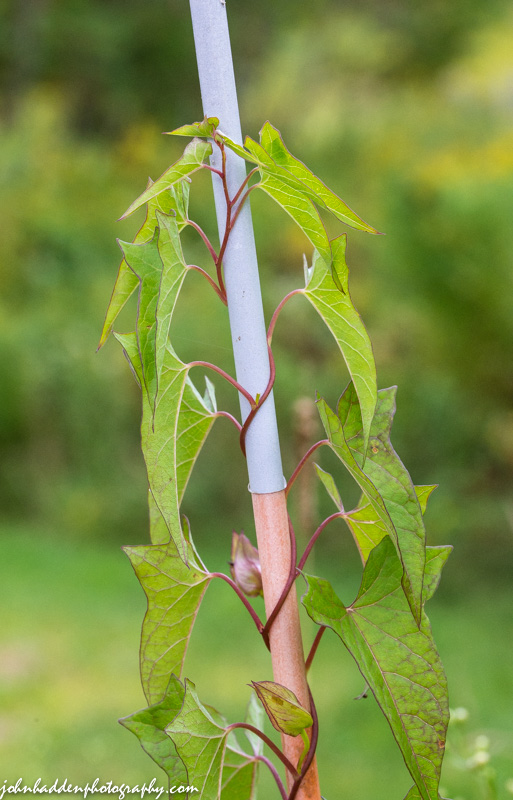
Bindweed climbing snow stake along the driveway
Morning Observation:
This morning in Huntington at 6:30AM it’s currently 46 degrees under clear skies. Winds are calm. Relative humidity is 98%, dewpoint 46, barometric pressure 30.34” and rising. Yesterday’s high was 76, and the overnight low was 46.
Forecast:
High pressure across New England into the Canadian Maritimes will continue to provide the region with lovely seasonably mild and dry weather through Wednesday. We’ll see sunny skies today with highs in the lower 70s and light and variable winds, becoming southerly around 10 mph this afternoon. Tonight should be mostly clear with lows in the upper 40s and south winds around 10 mph until midnight, becoming light and variable.
Wednesday should be mostly sunny with highs in the mid 70s and light and variable winds. Wednesday night should be partly cloudy with lows in the upper 50s and south winds around 10 mph.
A cold front will move in on Thursday bringing showers. Highs will be in the lower 70s with south winds 10 to 15 mph. Chance of rain is 70%. Thursday night should be partly cloudy with a 30% chance of showers. Lows will be in the upper 40s.
Almanac:
Last year on this date we had a high of 68 and a low of 37.
Burlington norms for this date are highs of 73 and lows of 53.
The record high was 98°F in 2002 (we had a high of 90).
The record low was 37°F in 1938.
Sky Notes:
Sunrise: 6:24 AM EDT
Sunset: 7:13 PM EDT
Length of Visible Light: 13h 48m
Length of Day: 12h 49m
Tomorrow will be 3m 0s shorter.
The Moon is waning gibbous (but pretty close to still full…), 14d 20h old with 100% illumination.
Moonrise: 7:27 PM EDT
Moonset: 6:59 AM EDT
About Today’s Photo:
Bindweed is all about in our front field (as anyone who’s gone after a volleyball in the tall grass can attest!). This motivated plant had climbed to near the top of a snow stake along our driveway.
Nikon D600, Sigma 105mm macro, ISO 1250, f/13, 1/500″ exposure.
Monday, September 8, 2014
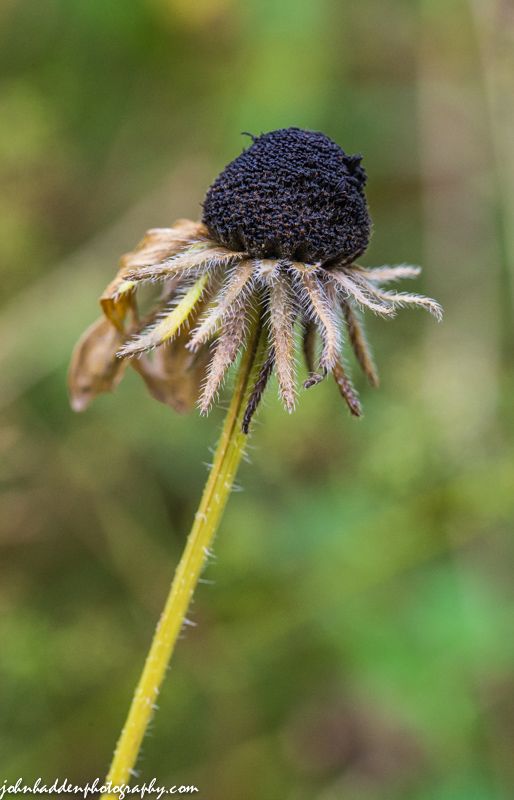
The dried eye of a black-eyed Susan
Morning Observation:
This morning in Huntington at 6:40AM it’s currently a cool 45 degrees under clear skies. Winds are calm. Relative humidity is 98%, dewpoint 44, barometric pressure 30.33” and rising. Yesterday’s high was 72, and the overnight low was 44.
Forecast:
High pressure will continue to dominate our weather for the next couple of days. We’ll see sunny skies today with highs in the lower 70s and light and variable winds. Tonight should be clear with lows in the upper 40s and light and variable winds.
Tuesday should be sunny with highs in the lower 70s and light and variable winds, becoming southerly around 10 mph in the afternoon. Tuesday night should be mostly clear with lows in the lower 50s and light and variable winds.
Wednesday’s looking partly sunny with highs in the lower 70s and southeast winds around 10 mph. A cold front with approach the region Wednesday night bringing partly cloudy skies and a 30% chance of showers. Lows will be in the upper 50s. Showers should continue into Thursday.
Almanac:
Last year on this date we had a high of 61 and low of 39. We picked up 0.29″ of rain.
Burlington norms for this date are highs of 74 and lows of 54.
The record high was 94°F in 1945.
The record low was 37°F in 1952.
Sky Notes:
Sunrise: 6:22 AM EDT
Sunset: 7:15 PM EDT
Length of Visible Light: 13h 51m
Length of Day: 12h 52m
Tomorrow will be 3m 0s shorter.
The Moon is the full “Harvest” moon (Northeast Native American, Colonial American, Neo Pagan Wiccan)
13d 20h old with 99% illumination.
Moonrise: 6:52 PM EDT
Moonset: 5:44 AM EDT
Other names for this month’s full moon include: “Fruit” (English); “Singing” (Celtic); and “Barley” (Medieval Wiccan).
About Today’s Photo:
The black-eyed Susans are drying out in our front field. All that’s left is the dried “eye”.
Nikon D600, Sigma 105mm macro lens, ISO 1250, f/13, 1/200″ exposure.
Sunday, September 7, 2014

Morning dew clings to white pine needles out by the pond
Morning Observation:
This morning in Huntington at 7:50AM it’s currently 51 degrees under clear skies. Winds are calm. Relative humidity is 99%, dewpoint 51, barometric pressure 30.07” and rising rapidly. We picked up 0.70” of rain yesterday afternoon between 1:30 and 4:30. Yesterday’s high was 77, and the overnight low got down to 46.
Forecast:
We’ve got some lovely cool late summer/early fall weather on tap for the next few days courtesy of a high pressure ridge that will bring cool, dry conditions to the region through most of the upcoming week. We’ll see mostly sunny skies today with highs around 70 and northwest winds around 10 mph. Tonight should be clear and cool with lows in the upper 30s to mid 40s with north winds around 10 mph until midnight, becoming light and variable.
Monday should be sunny wit highs in the lower 70s and light and variable winds, becoming southerly around 10 mph in the afternoon. Monday night should be mostly clear with lows in the mid 40s and southeast winds around 10 mph.
Tuesday’s looking mostly sunny with highs in the lower 70s and southeast winds around 10 mph. Tuesday night should be partly cloudy with lows in the lower 50s.
Almanac:
Last year on this date we had a high of 69 and lows of 47.
Burlington norms for this date are highs of 74 and lows of 54.
The record high was 94°F in 1945.
The record low was 36°F in 1962.
Sky Notes:
Sunrise: 6:21 AM EDT
Sunset: 7:17 PM EDT
Length of Visible Light: 13h 54m
Length of Day: 12h 55m
Tomorrow will be 2m 59s shorter.
Moon is waxing gibbous, 12d 21h old with 96% illumination.
Moonrise: 6:16 PM EDT
Moonset: 4:28 AM EDT
About Today’s Photo:
These white pine needles caught my eye this morning as I checked the rain gauge. I just had to grab my camera as the morning sun was angling in to light up the dew drops.
Nikon D600, Sigma 105mm macro lens, ISO 800, f/8, 1/60″ exposure.
Saturday, September 6, 2014

Queen Anne’s lace has gone to seed in the front field
Morning Observation:
This morning in Huntington at 7:30AM it’s currently a balmy 68 degrees under overcast skies. Relative humidity is 98%, dewpoint 68, barometric pressure 29.80”. We’ve had a couple of brief sprinkles this morning but nothing accumulating yet. Yesterday’s high was 84 and the overnight low was 66.
Forecast:
A slow moving cold front will drop through the region today bringing occasional showers and thunderstorms mainly this afternoon. It will be cooler today with highs in the lower 70s and southwest winds around 10 mph, becoming westerly this afternoon. Chance of rain is 80%. Tonight should be cloudy with a slight chance of showers and thunderstorms until midnight, then partly cloudy after midnight. It’ll be less humid with lows in the lower 50s and northwest winds around 10 mph until midnight, becoming light and variable. Chance of rain is 205.
Cool Canadian high pressure will build in Sunday and dominate the weather through the middle of next week. We’ll see mostly sunny skies with highs in the upper 60s and light and variable winds, becoming northwesterly 10 to 15 mph in the afternoon. Sunday night should be clear and cool with lows in the lower 40s. North winds around 10 mph.
Monday’s looking sunny with highs in the upper 60s and light and variable winds. Monday night should be mostly clear with lows in the upper 40s.
Almanac:
Last year on this date we had a high of 66 and a low of 37 (that’s pretty chilly!)
Burlington norms for this date are highs of 75 and lows of 54.
The record high was 90°F in 1945.
The record low was 37°F in 1938.
Sky Notes:
Sunrise: 6:21 AM EDT
Sunset: 7:19 PM EDT
Length of Visible Light: 13h 58m
Length of Day: 12h 58m
The Moon is waxing gibbous, 11d 21h old with 90% illumination.
Moonrise: 5:37 PM EDT
Moonset: 3:14 AM EDT
About Today’s Photo:
Queen Anne’s lace has started to go to seed in the front field. I love the way the formerly flat flower heads curl and cup into themselves as the seed head ripens.
Nikon D600, Sigma 105mm lens, ISO 1250, f/13, 1/320″ exposure.
Friday, September 5, 2014

Yellow jewel weed blooming by our woodpile
Morning Observation:
This morning in Huntington at 6:40AM it’s currently 61 degrees under partly cloudy skies. Winds are calm. Relative humidity is 99%, dewpoint 60, barometric pressure 30.06” and falling. Yesterday’s high was 81, and the overnight low was 60.
Forecast:
High pressure is currently slipping off the New England coast and will put us on the warm and muggy side of a southerly airflow today. We’ll see partly sunny skies with highs in the mid 80s to near 90 — a good 10 to 15 degrees above normal for this time of year — with south winds 10 to 15 mph. Tonight should be partly cloudy and muggy with lows in the upper 60s and south winds 10 to 15 mph.
A slow moving cold front will move into the region Saturday bringing a chance of thunderstorms and occasional showers. It will be seasonably cooler with highs in the mid 70s and southwest winds around 10 mph, becoming northwesterly and gusting up to 25 mph in the afternoon. Chance of rain is 80%. Saturday night should be partly cloudy with a chance of showers and thunderstorms. It’ll be less humid with lows around 50 and northwest winds around 10 mph. Chance of rain is 50%.
Canadian high pressure will slide in for Sunday bringing sunny skies with highs in the upper 60s and light and variable winds. Sunday night should be clear and cool with lows in the upper 40s.
Almanac:
Last year on this date we had a high of 62 and a low of 40.
Burlington norms for this date are highs of 75 and lows of 55.
The record high was 90°F in 1973.
The record low was 37°F in 1963.
Sky Notes:
Sunrise: 6:19 AM EDT
Sunset: 7:21 PM EDT
Length of Visible Light: 14h 01m
Length of Day: 13h 01m
The Moon is waxing gibbous, 10d 20h old with 82% illumination.
Moonrise: 4:54 PM EDT
Moonset: 2:04 AM EDT
About Today’s Photo:
Yellow jewel weed, or touch-me-not, along with its orange variety, is in full bloom all over the place. I love touching the ripened seed pods and having them burst in my fingers!
Nikon D600, Sigma 105mm macro lens, ISO 1250, f/8, 1/500″ exposure.
Thursday, September 4, 2014

A yellow garden spider enjoys a meal in her web in the front field.
Morning Observation:
This morning in Huntington at 6:40AM it’s currently 51 degrees under partly cloudy skies. Wind are calm. Relative humidity is 99%, dewpoint 51, barometric pressure 30.12”. Yesterday’s high was 76, and the overnight low was 51.
Forecast:
High pressure will continue to bring plenty of sunshine and above normal temperatures today and Friday. We’ll see sunny skies with highs in the lower 80s and light and variable winds, becoming southwesterly around 10 mph this afternoon. Tonight should be mostly clear until midnight, then becoming partly cloudy. Lows will be in the lower 60s with light and variable winds.
Friday’s looking partly sunny, warmer and more humid with highs in the mid 80s. Winds will be out of the south at around 10 mph and gusting up to 25 mph in the afternoon. A slow moving cold front will approach the region Friday night bringing partly cloudy skies with a chance of showers. Lows will be in the mid 60s with south winds around 10 mph. Chance of rain is 50%.
Saturday should bring occasional showers with a chance of thunderstorms as the cold and associated low pressure front moves through. It will be seasonably cooler with highs in the lower 70s and west winds around 10 mph. Chance of rain is 80%. Saturday night should be partly cloudy with lows in the upper 40s. High pressure is on track to build in for Sunday so we should see a nice, seasonably cool day.
Almanac:
Last year on this date we had a high of 73 and a low of 52. We picked up 0.23″ of rain.
Burlington norms for this date are highs of 75 and lows of 55.
The record high was 93°F in 1999 (we had a high of 91).
The record low was 40°F in 1924.
Sky Notes:
Sunrise: 6:18 AM EDT
Sunset: 7:23 PM EDT
Length of Visible Light: 14h 04m
Length of Day: 13h 04m
The Moon is waxing gibbous, 9d 20h old with 72% illumination.
Moonrise: 4:05 PM EDT
Moonset: 12:59 AM EDT
About Today’s Photo:
I almost walked right through this yellow garden spider’s web yesterday morning as I was out in the front field. She was enjoying a meal of a small fly. I particularly like the detail view of her spinnerets low on her abdomen.
Nikon D600, Sigma 105mm macro lens, ISO 1250, f/13, 1/125″ exposure.
Wednesday, September 3, 2014

An odd little winged weevil-like bug deep in the goldenrod
Morning Observation:
This morning in Huntington at 6:40AM it’s currently 60 degrees under overcast skies. Wind are calm. Relative humidity is 99%, dewpoint 59, barometric pressure 29.84” and rising rapidly. We picked up 0.85” of rain in the past 24hrs. Yesterday’s high was 85, and the overnight low was 58.
Forecast:
High pressure is currently building into the region and will deliver dry weather through Friday. We’ll see partly sunny skies today with highs in the mid 70s and west winds around 10 mph. Tonight should be clear with lows in the upper 50s and west winds around 10 mph until midnight, becoming light and variable.
Thursday should be sunny and warmer with highs in the upper 70s and light and variable winds, becoming southwesterly around 10 mph in the afternoon. Thursday night should be mostly clear with lows in the lower 60s and south winds around 10 mph.
Friday’s looking partly sunny, warmer, and more humid with highs in the lower 80s and south winds 10 to 15 mph.
A cold front will approach the region Friday night bringing showers and a chance of thunderstorms. Lows will be in the lower 60s. Chance of rain is 60%.
Almanac:
Last year on this date we had a high of 75 and a low of 58. We picked up 0.23″ of rain.
Burlington norms for this date are highs of 76 and lows of 55.
The record high was 92°F in 2010 (we had a high of 89).
The record low was 38°F in 1960.
Sky Notes:
Sunrise: 6:17 AM EDT
Sunset: 7:25 PM EDT
Length of Visible Light: 14h 07m
Length of Day: 13h 07m
The Moon is waxing gibbous, 8d 20h old with 61% illumination.
Moonrise: 3:12 PM EDT
Moonset: 12:01 AM EDT
About Today’s Photo:
I’m not sure what this little bug is, but he/she was busy flitting about and needling the goldenrod flowers in our front field with its long proboscis.
Nikon D600, Sigma 105mm macro lens, ISO 1250, f/16, 1/400″ exposure.
Tuesday, September 2, 2014

Butter & Eggs blooming along the tracks in Jonesville
Morning Observation:
This morning in Huntington at 6:45AM it’s currently 66 degrees under mostly cloudy skies. Winds are calm. Relative humidity is 99%, dewpoint 65, barometric pressure 29.82”. Yesterday’s high was 84, and the overnight low was 63.
Forecast:
We’ll see partly sunny skies with a chance of showers this morning, then showers and thunderstorms likely this afternoon and evening as a cold front crosses the region. Some thunderstorms may produce gusty winds and small hail this afternoon and evening. Highs will be in the lower 80s with south winds around 10 mph. Chance of rain is 70%. Tonight will be cloudy with showers and thunderstorms likely until midnight, then a chance of showers after midnight. Lows in the lower 60s with light and variable winds. Chance of rain is 70%.
The cold front will clear the region by Wednesday and high pressure will build into the region for the next few days. We’ll see partly sunny skies with highs in the mid 70s and west winds around 10 mph. Wednesday night should be clear with lows in the upper 50s and southwest winds around 10 mph.
Thursday’s looking Mostly sunny with highs in the mid 70s and southwest winds around 10 mph. Thursday night should be partly cloudy with lows in the lower 60s.
Almanac:
Last year on this date we had a high of 79 and a low of 61. We picked up 0.46″ of rain.
Burlington norms for this date are highs of 76 and lows of 56.
The record high was 91°F in 2010 (we had a high of 89).
The record low was 38°F in 1967.
Sky Notes:
Sunrise: 6:16 AM EDT
Sunset: 7:27 PM EDT
Length of Visible Light: 14h 10m
Length of Day: 13h 10m
Moon is in its first quarter, 7d 20 old with 50% illumination.
Moonrise: 2:14 PM EDT
No Moon Set
About Today’s Photo:
Another shot from along the tracks in Jonesville. This time I’m serving up butter & eggs.
Nikon D600, Sigma 105mm lens, ISO 80, f/8, 1/320″ exposure.
