Saturday, June 29, 2019


An ant slurps up nectar on a daisy fleabane
Morning Observation:
This morning in Huntington at 6:10AM it’s currently 61 degrees and drizzling lightly under overcast skies. Winds are calm. Relative humidity is 97%, dewpoint 61, barometric pressure 29.98” and falling slowly. We picked up 0.06” of rain overnight. Yesterday’s high was 87, and the overnight low was 61.
Forecast:
We’ve got a rainy weekend ahead of us. A stalled frontal boundary will slide eastward as a cold front this afternoon bringing showers and thunderstorms across the regions. Temperatures today will once again climb to near 80 degrees ahead of the cold front. A strong upper level low moving out of the northern Great Lakes will head our way this evening and be overhead Sunday bringing more showers and thunderstorms through Sunday afternoon. Monday should be drier with deep layer high pressure building across the region. Tuesday and Wednesday should also trend drier but afternoon showers and thunderstorms are a possibility as temperatures warm well into the 80s each day.
We’ll see mostly cloudy skies today with showers likely along with\ thunderstorms this afternoon. Highs will be near 77 with south winds 6 to 10 mph becoming northwesterly in the afternoon and gusting to 20 mph. Chance of precipitation is 70% with rainfall amounts between 1/10″-1/4″ with higher amounts possible in thunderstorms. Tonight should be mostly cloudy with a 60% chance of showers and thunderstorms. Lows will be around 60 with south winds 5 to 7 mph becoming light and variable after midnight. Rainfall amounts between 1/10″-14″ are possible with higher amounts possible in thunderstorms.
Sunday should be cloudy with showers and thunderstorms likely. It’ll be on the cool side with highs only near 69 and light and variable winds becoming northerly 6 to 11 mph in the morning. Chance of precipitation is 80% with rainfall amounts between 1/4″-1/2″ possible. Sunday night should be mostly cloudy with a 40% chance of showers. Lows will be around 57 with north winds 3 to 7 mph.
Monday’s looking mostly sunny with a high near 80 and northwest winds 3 to 7 mph. Monday night should be mostly cloudy with a 40% chance of showers. Lows will be around 59 with calm winds.
Almanac:
Last year on this date we had a high of 85 and a low fo 57. We picked up 0.33″ of rain.
Burlington averages for this date are a low of 59 and a high of 80.
The record low was 40 in 1988.
The record high was 96 in 1946.
Sky Notes:
Sunrise: 5:10AM
Sunset: 8:40PM
Length of day: 15:29:21
Today will be 0:32 shorter than yesterday.
The Moon is a waning crescent, 26 days old with 15% illumination.
Moonrise: 2:50AM
Moonset: 5:22PM
About Today’s Photo:
Bees and other flying insects aren’t the only critters that help pollinate flowers. Ants—drawn to the sweet nectar of the blossoms—also aid in the pollination of this daisy fleabane growing in our front field.
Panasonic GX8, Olympus 60mm macro lens, ISO 800, f/4.5, 1/5000″ exposure.
Friday, June 28, 2019

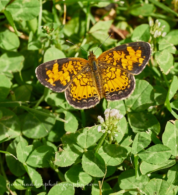
A pearl crescent in the clover of our front yard
Morning Observation:
This morning in Huntington at 6:45AM it’s currently 56 degrees under partly cloudy skies. Winds are calm. Relative humidity is 98%, dewpoint 55, barometric pressure 30.12” and rising slowly. We picked up 0.14” overnight as a quick shower moved through. Yesterday’s high was 85, and the overnight low was 54.
Forecast:
We’ve got another warm day on tap today with showers and embedded thunderstorms arriving tonight into Saturday as decaying low pressure moves in from the Great Lakes. A more organized low moving across central Québec Saturday will swing a cold front through the region Saturday afternoon bringing more showers and thunderstorms in the afternoon, overnight, and lingering into Sunday. Temperatures will be noticeably cooler on Sunday with daytime highs only in the upper 60s to lower 70s.
We’ll see sunny skies today with a high near 86 and south winds around 6 mph becoming westerly in the afternoon. Tonight should bring increasing clouds and a rising chance of showers and thunderstorms. Lows will be around 63 with west winds around 5 mph becoming southeast after midnight. Chance of precipitation is 40% with rainfall amounts of less than 1/10″ expected, except for higher amounts in thunderstorms.
Saturday should be mostly cloudy with showers and thunderstorms likely. Highs will be near 76 with south winds around 6 mph becoming westerly in the afternoon. Chance of precipitation is 60% with rainfall amounts between 1/10″-1/4″ possible, with higher amounts in thunderstorms. Saturday night should be mostly cloudy with a 60% chance of showers and thunderstorms. Lows will be around 60 with west winds 3 to 7 mph. Rainfall amounts of less than 1/10″ are expected higher amounts possible in thunderstorms.
Sunday should be cloudy with showers likely. Highs will be near 69 with northwest winds 6 to 9 mph. Chance of precipitation is 70% with rainfall amounts between 1/10″-1/4″ possible. Sunday night should be mostly cloudy with a 30% chance of showers in the evening. Lows will be around 56 with north winds 5 to 8 mph becoming calm in the evening.
Almanac:
Last year on this date we had a high of 85 and a low of 57. We picked up 0.33″ of rain.
Burlington averages for this date are a low of 59 and a high of 80.
The record low was 45 in 1980.
The record high was 95 in 1991.
Sky Notes:
Sunrise: 5:10AM
Sunset: 8:40PM
Length of day: 15:29:53
Today will be 0:28 shorter than yesterday.
The Moon is a waning crescent, 25 days old with 23% illumination.
Moonrise: 2:21AM
Moonset: 4:14PM
About Today’s Photo:
You may have seen some of these diminutive butterflies (1″-1.5″ wide) flitting about lawns, fields, and driveways over the past couple of weeks. Pearl crescents are a common butterfly in the region and you’ll often see them chasing each other about as they feed and mate. Several generations will be born in summer.
Panasonic GX8, Olympus 60mm macro lens, ISO 800, f/8, 1/400″ exposure.
Thursday, June 27, 2019

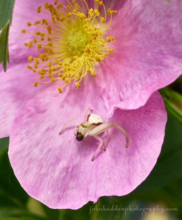
A crab spider munches its catch
Morning Observation:
This morning in Huntington at 7:00AM it’s currently 59 degrees under clear skies. Winds are calm. Relative humidity is 99%, dewpoint 59, barometric pressure 30.07” and rising slowly. We picked up 0.67” of rain in the past 24hrs. Yesterday’s high was 84, and the overnight low was 57.
Forecast:
We’ve got another warm summer day on tap for today with temperatures similar to or even slightly warmer than yesterday. After a dry start to the day today, some showers and thunderstorms will develop near the International Border this evening as a weak trough skirts north of the region. Showers should diminish by Friday morning a brief period of dry weather Friday as weak high pressure builds in. More showers will return Saturday as a more organized low pressure system heads our way from the Great Lakes. Temperatures should be seasonably warm through Friday before a cooling trend arrives going into the weekend.
We’ll see sunny skies today with highs in the lower 80s and light and variable winds, becoming westerly around 10 mph this afternoon. Tonight should be mostly clear until midnight, then become partly cloudy with a slight chance of showers and thunderstorms north. Lows will be in the lower 60s with west winds around 10 mph until midnight, becoming light and variable.
Friday should be mostly sunny with a slight chance of showers and thunderstorms in the afternoon. Highs will be in the lower 80s with light and variable winds, becoming westerly around 10 mph in the afternoon. Friday night should be mostly cloudy with a 40% chance of showers. Lows will be in the lower 60s with south winds around 10 mph.
Saturday should be cloudy with showers likely and a chance of thunderstorms. Highs will be in the mid 70s with west winds around 10 mph. Chance of rain is 70%. Saturday night should be cloudy with showers likely. Lows will be in the upper 50s. Chance of rain 60 percent with rainfall amounts between 1/4″-1/2″ expected.
Almanac:
Last year on this date we had a high of 75 and a low of 51.
Burlington averages for this date are a low of 59 and a high of 79.
The record low was 46 in 2004 (we had a low of 41).
The record high was 99 in 1941.
Sky Notes:
Sunrise: 5:09AM
Sunset: 8:40PM
Length of day: 15:30:21
Today will be 0:23 shorter than yesterday.
The Moon is a waning crescent, 24 days old with 32% illumination.
Moonrise: 1:55AM
Moonset: 3:08PM
About Today’s Photo:
Crab spiders are lurkers. Instead of weaving a web, they hide out in the petals of flowers—in this case, a rugosa rose by the pond—waiting for their prey to come into range. Then they quickly grab their quarry and devour it in place. Often the spider will be the same color as the flower they’re perched on, making it that much harder to see them. I’ve often taken pictures of a blossom only to discover that there was a spider lurking there when I looked at the image on my computer.
Panasonic GX8, Olympus 60mm macro lens, ISO 800, f/13, 1/320″ exposure.
Wednesday, June 26, 2019


Raindrops bead on lady’s mantle
Morning Observation:
This morning in Huntington at 6:15AM it’s currently 57 degrees under clear skies. Winds are calm. Relative humidity is 98%, dewpoint 56, barometric pressure 29.98” and rising slowly. We picked up 0.50” of rain in the past 24hrs. Yesterday’s high was 79, and the overnight low was 56.
Forecast:
We’ve got warm and moderately humid summertime weather on tap today and through the end of the week courtesy of weak high pressure over the region. A large, upper level low over James Bay will rotate an area of instability through the region later today kicking off scattered showers and terrain driven thunderstorms this afternoon and evening. Mainly dry weather is expected Thursday and Friday with the possibility of a stray terrain driven shower or thunderstorm each day. A better chance for more organized showers will arrive by the weekend as a cold front pushes through the region.
We’ll see mostly sunny skies today with a slight chance of showers and thunderstorms this afternoon. Highs will be in the lower 80s with light and variable winds. Tonight should be partly cloudy with a 50% chance of showers and thunderstorms until midnight, then mostly clear with a slight chance of showers and thunderstorms after midnight. Lows will be in the lower 60s with light and variable winds.
Thursday should be mostly sunny with a slight chance of showers and thunderstorms in the afternoon. Highs will be in the lower 80s with light and variable winds, becoming westerly around 10 mph in the afternoon. Thursday night should be mostly clear with lows in the lower 60s and west winds around 10 mph.
Friday’s looking mostly sunny with highs in the lower 80s and light and variable winds. Friday night should be partly cloudy with a 40% chance of showers. Lows will be in the lower 60s.
Almanac:
Last year on this date we had a high of 78 and a low of 40.
Burlington averages for this date are a low of 58 and a high of 79.
The record low was 41 in 1979.
The record high was 96 in 2007 (we had a high of 92).
Sky Notes:
Sunrise: 5:09AM
Sunset: 8:40PM
Length of day: 15:30:45
Today will be 0:19 shorter than yesterday.
The Moon is a waning crescent, 23 days old with 42% illumination.
Moonrise: 1:34AM
Moonset: 2:05PM
About Today’s Photo:
We have several plantings of lady’s mantle in our back garden. I’m always drawn to them after a rain as the fine hairs along the edges of the leaves allow raindrops to bead on the serrated fringes.
Panasonic GX8, Olympus 60mm macro lens, ISO 800, f/4, 1/250″ exposure.
Tuesday, June 25, 2019

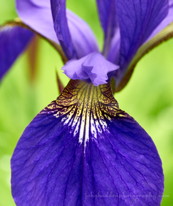
In close with an iris blossom by the pond
Morning Observation:
This morning in Huntington at 7:50AM it’s currently 66 degrees under overcast skies. Winds are calm. Relative humidity is 85%, dewpoint 62, barometric pressure 29.77” and steady. Yesterday’s high was 79, and the overnight low was 52.
Forecast:
Low pressure just south of James Bay this morning will push an occluded front through the region today bringing a band of light to moderate rainfall through the area this morning into early afternoon. Rainfall should wind down later in the day into tonight. Warm and humid weather will move in for Wednesday into Friday along with chances for afternoon showers and a few thunderstorms each day as diurnal heating interacts with weak disturbances crossing the region each day. A more organized low pressure system looks to be in the cards for Saturday with showers and thunderstorms moving in with the arrival of a cold front.
We’ll see cloudy skies today with showers likely and a slight chance of thunderstorms this afternoon. Highs will be in the lower 70s with south winds around 10 mph. Chance of rain is near 100% with 1/4″-1/2″ of rainfall possible. Tonight should be partly cloudy with a 50% chance of showers and thunderstorms until midnight. Lows will be around 60 with south winds around 10 mph until midnight, becoming light and variable.
Wednesday should be mostly sunny with a 30% chance of showers and thunderstorms in the afternoon. It’ll be warmer and more humid with highs in the lower 80s and light and variable winds, becoming southerly around 10 mph in the afternoon. Wednesday night should be partly cloudy with a 50% chance of showers and thunderstorms. Lows will be in the lower 60s with south winds 10 to 15 mph.
Thursday should be mostly sunny with highs in the lower 80s and southwest winds around 10 mph. Thursday night should be partly cloudy with lows in the lower 60s.
Almanac:
Last year on this date we had a high of 69 and a low of 44.
Burlington averages for this date are a low of 58 and a high of 79.
The record low was 39 in 1979.
The record high was 94 in 1995.
Sky Notes:
Sunrise: 5:09AM
Sunset: 8:40PM
Length of day: 15:31:05
Today will be 0:15 shorter than yesterday.
The Moon is in its last quarter, 22 days old with 51% illumination.
Moonrise: 1:09AM
Moonset: 1:04PM
About Today’s Photo:
Looking in close at an iris blooming by the pond reveals the intricate patterning of the blossoms petals. A blast of deep indigo against the green.
Panasonic GX8, Olympus 60mm macro lens, ISO 800, f/5.6, 1/100″ exposure.
Monday, June 24, 2019


Subtle colors on the eastern horizon at sunset on Lake Champlain
Morning Observation:
This morning in Huntington at 6:35AM it’s currently 50 degrees under clear skies. Winds are calm. Relative humidity is 98%, dewpoint 49, barometric pressure 29.86” and rising. Yesterday’s high was 81, and the overnight low was 48.
Forecast:
We’ve got another lovely day on tap today courtesy of high pressure which is cresting over the region today. Expect plenty of sunshine and seasonable temperatures. A trough of low pressure will move our way from the norther Great Lakes tonight bringing showers and possibly a few thunderstorms Tuesday. Above normal temperatures are expected for Wednesday along with the possibility of a few showers or storms in the afternoon.
We’ll see sunny skies today Highs in the upper 70s and light and variable winds. Tonight should be mostly clear until midnight then become partly cloudy. Lows will be in the mid 50s with light and variable winds, becoming southeasterly around 10 mph after midnight.
Tuesday showers are likely in the morning with showers and a slight chance of thunderstorms in the afternoon. Highs will be in the lower 70s with southeast winds 10 to 15 mph. Chance of rain is 90%. Tuesday night should be partly cloudy with a 50% chance of showers. Lows will be around 60 with south winds around 10 mph.
Wednesday should be partly sunny with a 40% chance of showers and thunderstorms in the afternoon. Highs will be in the lower 80s with southwest winds around 10 mph. Wednesday night should be partly cloudy with a 50% chance of showers. Lows will be in the lower 60s.
Almanac:
Last year on this date we had a high of 66 and a low of 56. We picked up 0.20″ of rain.
Burlington averages for this date are a low of 58 and a high of 79.
The record low was 40 in 1988.
The record high was 96 in 2003 (we had a high of 92).
Sky Notes:
Sunrise: 5:08AM
Sunset: 8:40PM
Length of day: 15:31:20
Today will be 0:11 shorter than yesterday.
The Moon is waning gibbous, 21 days old with 61% illumination.
Moonrise: 12:45AM
Moonset: 12:03PM
About Today’s Photo:
We anchored our little boat, Lyra, off of a little beach on the Alburg shore just north of North Hero the other night and watched as the colors drained from the sky to the east. The strong northwest winds that had been churning the water throughout the day finally settled down giving us at tranquil night. In this view, the tip of North Hero can be seen to the center left of the image.
Panasonic GX8, Olympus 9-18mm lens @ 9mm, circular polarizing filter, ISO 800, f/10, 1/100″ exposure.
Friday, June 21, 2019; The Summer Solstice

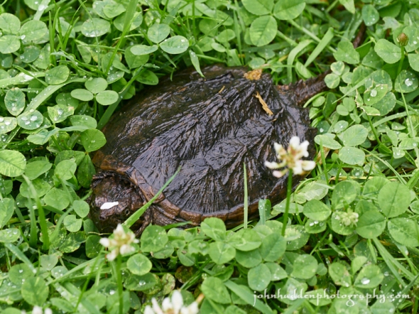
A baby snapping turtle in our front yard
Happy Solstice!
Morning Observation:
This morning in Huntington at 7:05AM it’s currently 58 degrees and sprinkling lightly under overcast skies. Winds are calm. Relative humidity is 97%, dewpoint 57, barometric pressure 29.55” and rising slowly. We picked up 1.98” of rain in the past 24hrs. Yesterday’s high was 69, and the overnight low was 58.
Forecast:
A shortwave trough moving south of the region this morning will bring showers across southern Vermont this morning. We should see cloudy skies today locally with a possibility for some more showers this afternoon as another shortwave trough slides to our north. Temperatures will be on the cool side today—in the mid 60s. High pressure will build into the region tonight allowing for some clearing this weekend. Another weak shortwave trough will slide through on Saturday bringing the slight chance of showers to north central and northeast Vermont, but we should be dry on Sunday with increasing amounts of sunshine and a gradual warming trend as well.
We’ll see cloudy skies today with a 20% chance of showers. Highs will be in the mid 60s with northwest winds 10 to 15 mph. Tonight should be mostly cloudy with a slight chance of showers until midnight, then partly cloudy after midnight. Lows will be in the lower 50s with northwest winds around 10 mph.
Saturday should be partly sunny with a slight chance of showers in the afternoon. Highs will be in the lower 70s with northwest winds 15 to 20 mph gusting up to 30 mph. Saturday night should be clear with lows in the lower 50s and northwest winds 10 to 15 mph gusting to 25 mph.
Sunday’s looking sunny with highs in the mid 70s and northwest winds 10 to 15 mph gusting up to 25 mph. Sunday night should be clear with lows in the lower 50s.
Almanac:
Last year on this date we had a high of 70 and a low of 56.
Burlington averages for this date are a low of 57 and a high of 78.
The record low was 44 in 1986.
The record high was 97 in 2012 (we had a high of 92).
Sky Notes:
Sunrise: 5:07AM
Sunset: 8:39PM
Length of day: 15:31:40
Today will be 0:01 longer than yesterday.
The Moon is waning gibbous, 18.5 days old with 85% illumination.
Moonrise: 11:52PM
Moonset: 9:03AM
The Summer Solstice will occur this morning at 11:54AM. The Solstice occurs when the Earth’s rotational axis is most inclined toward the Sun. On the summer solstice, Earth’s maximum axial tilt toward the Sun is 23.44°. In the northern hemisphere, this marks the beginning of astronomical summer and is the longest day of the year. Here’s a handy graphic:

About Today’s Photo:
As I crossed the front yard from my studio to the house yesterday evening, I came across this young snapping turtle in the grass. He was about 4″ in diameter. He was headed towards our front field—in the opposite direction of our pond—and I wasn’t entirely sure where he came from or where he was headed. I carefully picked him up and carried him over to the edge of the pond where he enthusiastically crawled into the water.
Panasonic GX8, Lumix 14-140mm lens @ 109mm, ISO 800, f/8, 1/125″ exposure.
Thursday, June 20, 2019


A dragonfly pauses on a blade of grass by the pond
Morning Observation:
This morning in Huntington at 6:15AM it’s currently a juicy 62 degrees under overcast skies. Winds are calm. Relative humidity is 98%, dewpoint 62, barometric pressure 29.65” and steady. We picked up 0.07” of rain in the past 24hrs. Yesterday’s high was 81, and the overnight low was 60.
Forecast:
We’ve got a soaker on tap for today into Friday morning. Low pressure moving out of the Ohio River valley will deliver moderate to heavy rainfall this afternoon into Friday morning over a good part of the North Country. We should see between 1″-2″ of rainfall with localized flooding possible of smaller rivers and streams. Rainfall should end by midday Friday with cooler and drier conditions expected for Friday afternoon into Saturday. A warming trend will begin on Sunday and continues into early next week with daytime highs bumping into the mid 80s. The next round of showers and thunderstorms should arrive late Monday.
We’ll see cloudy skies today with showers likely. Locally heavy rainfall is possible this afternoon. Highs will be around 70 with light and variable winds. Chance of rain is near 100%. Tonight should be cloudy with showers likely. Locally heavy rainfall is possible until midnight. Lows will be in the mid 50s with light and variable winds becoming northerly around 10 mph after midnight. Chance of rain is near 100% with between 1″-2″ of rainfall expected.
Friday should be mostly cloudy with a 40% chance of showers in the morning. Highs will be around 70 with north winds 10 to 15 mph. Friday night should be partly cloudy with lows in the lower 50s and northwest winds around 10 mph.
Saturday’s looking partly sunny with highs in the mid 70s and northwest winds 10 to 15 mph gusting up to 35 mph. Saturday night should be mostly clear with lows in the lower 50s.
Almanac:
Last year on this date we had a high of 79 and a low of 45.
Burlington averages for this date are a low of 57 and a high of 78.
The record low was 44 in 1968.
The record high was 95 in 2012 (we had a high of 92).
Sky Notes:
Sunrise: 5:07AM
Sunset: 8:39PM
Length of day: 15:31:38
Today will be 0:06 longer than yesterday.
The Moon is waning gibbous, 17.5 days old with 91% illumination.
Moonrise: 11:19PM
Moonset: 8:03AM
About Today’s Photo:
The dragonflies are flying! This diminutive little fellow was prowling the grasses along the edge of our pond the other day. Wally J., care to identify it for me?
Panasonic GX8, Olympus 60mm macro lens, ISO 800, f/5.6, 1/160″ exposure.
Wednesday, June 19, 2019

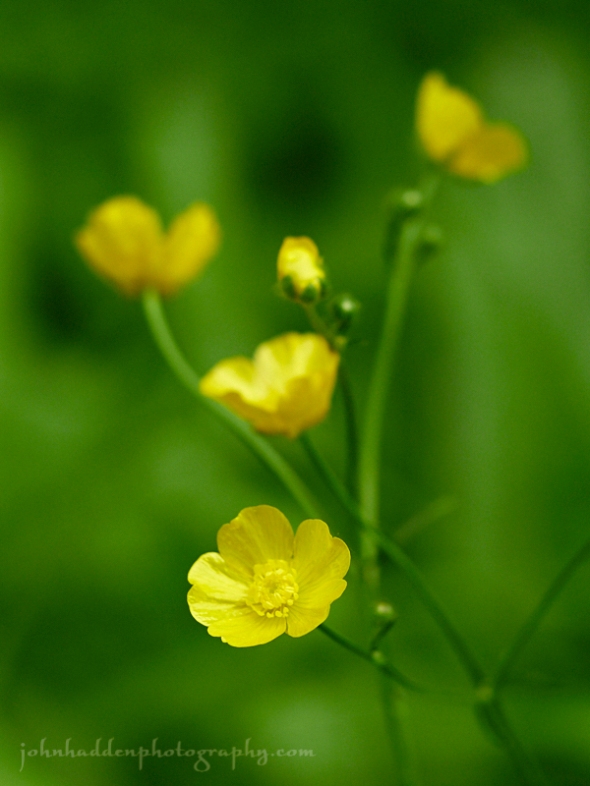
Buttercups in our front field
Morning Observation:
This morning in Huntington at 6:30AM it’s currently 59 degrees under mostly cloudy skies. Winds are calm. Relative humidity is 98%, dewpoint 58, barometric pressure 29.82” and steady. Yesterday’s high was 80, and the overnight low was 53.
Forecast:
The dry and tranquil weather that we’ve been enjoying for the past several days will come to an end this morning. We’ll be sandwiched between two weak lows today—one passing south through southern New England, and one north through Québec. A surface trough will cross our region this afternoon bringing scattered showers and a chance of thunderstorms. A more widespread moderate to locally heavy rainfall is expected Thursday afternoon and night before as a moisture laden low heads our way from the Ohio River valley. Drier weather returns for Friday into the weekend with temperatures heading towards the mid 80s on Sunday.
We’ll see partly sunny skies this morning, giving way to mostly cloudy skies and a 50% chance of showers and thunderstorms this afternoon. Highs will be in the upper 70s with light and variable winds, becoming southerly around 10 mph this afternoon. Tonight should be mostly cloudy with a 50% chance of showers. Lows will be in the upper 50s with light and variable winds.
Thursday should be cloudy with showers likely in the afternoon. Highs will be around 70 with light and variable winds. Chance of rain is near 100%. Thursday night, showers are likely. Lows will be in the mid 50s with north winds around 10 mph. Chance of rain is near 100%. Total rainfall from the event could be on the order of 1″.
Friday’s looking mostly cloudy with a 50% chance of morning showers. It’ll be on the cool side with highs in the upper 60s and northwest winds 10 to 15 mph. Friday night should be partly cloudy Lows in the lower 50s.
Almanac:
Last year on this date we had a high of 72 and a low of 49. We picked up 1″ of rain.
Burlington averages for this date are a low of 57 and a high of 77.
The record low was 37 in 1946.
The record high was 100 in 1995.
Sky Notes:
Sunrise: 5:07AM
Sunset: 8:39PM
Length of day: 15:31:32
Today will be 0:10 longer than yesterday.
The Moon is waning gibbous, 16.6 days old with 96% illumination.
Moonrise: 10:42PM
Moonset: 7:06PM
About Today’s Photo:
Bright like the sun, buttercups shine in the green fields this time of year. Their lustrous petals help attract pollinators while helping to regulate temperatures for the flower’s reproductive organs.
Panasonic GX8, Olympus 60mm macro lens, ISO 800, f/2.8, 1/800″ exposure.
Tuesday, June 18, 2019

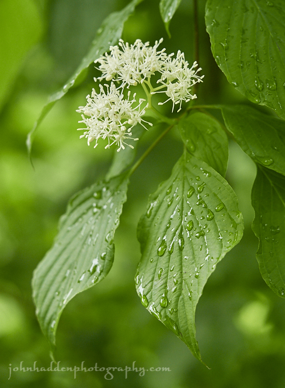
Pagoda dogwood flowering along our driveway
Morning Observation:
This morning in Huntington at 6:45AM it’s currently 55 degrees under overcast skies. Winds are calm. Relative humidity is 95%, dewpoint 54, barometric pressure 29.97” and steady. Yesterday’s high was 75, and the overnight low was 53.
Forecast:
Warm and tranquil weather will continue today as we remain under the influence of weak high pressure over the region. Low pressure passing to our south will bring clouds today, and a slight chance of terrain driven showers over higher elevations this afternoon. Wednesday should be similar with a slightly better chance of afternoon convections-driven showers and thunderstorms. Low pressure moving out of the Ohio River valley on Thursday will bring a more widespread rainfall Thursday afternoon and night. Drier conditions should return for Friday into the weekend. Temperatures will be seasonal throughout the period with daytime highs in the mid 70s and evening lows in the 50s.
We’ll see mostly cloudy this morning, then partly sunny skies with a slight chance of showers this afternoon. Highs will be in the upper 70s with light and variable winds. Tonight should be mostly clear until midnight, then become partly cloudy. Lows will be in the mid 50s with light and variable winds.
Wednesday should be partly sunny with a 50% chance of showers and a chance of thunderstorms in the afternoon. Highs will be in the upper 70s with south winds around 10 mph. Wednesday night should be partly cloudy with a 50% chance of showers and thunderstorms. Lows will be in the lower 60s with light and variable winds.
Thursday should be cloudy with showers likely. Highs will be in the lower 70s with light and variable winds. Chance of rain is 70%. Thursday night showers are likely. Lows will be in the mid 50s. Chance of rain is 90% with 3/4″-1″ of rain possible.
Almanac:
Last year on this date we had a high of 83 and a low of 62.
Burlington averages for this date are a low of 56 and a high of 77.
The record low was 40 in 1964.
The record high was 97 in 1994.
Sky Notes:
Sunrise: 5:07AM
Sunset: 8:38PM
Length of day: 15:31:22
Today will be 0:14 longer than yesterday.
The Moon is waning gibbous, 15.6 days old with 99% illumination.
Moonrise: 9:56PM
Moonset: 6:12AM
About Today’s Photo:
Pagoda dogwood is in flower now in the woods. This small tree brightens up the forest understory with its clusters of white flowers. Later in the summer, the dark purple berries will provide food for a variety of critters including birds and bears.
Panasonic GX8, Olympus 60mm macro lens, ISO 800, f/2.8, 1/250″ exposure.
Monday, June 17, 2019
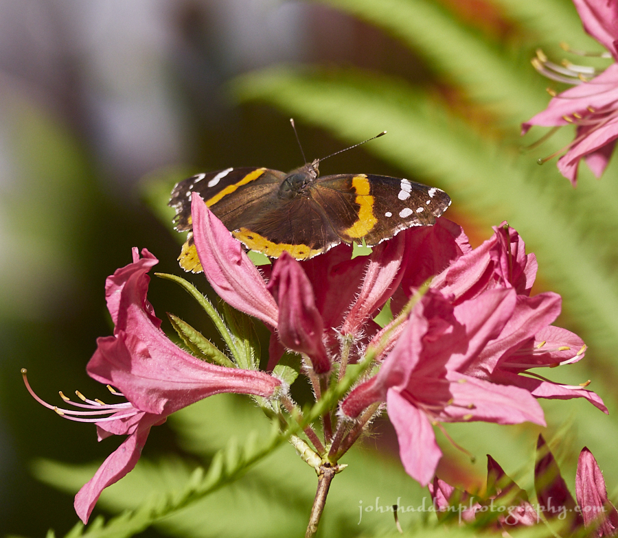
A red admiral visits our azalea by the side of the house
Morning Observation:
This morning in Huntington at 6:50AM it’s currently 49 degrees under partly cloudy skies. Winds are calm. Relative humidity is 98%, dewpoint 49, barometric pressure 29.97” and rising slowly. Yesterday’s high was 71, and the overnight low was 44.
Forecast:
We’ve got a nice start to the week ahead courtesy of surface high pressure building in from the northern Great Lakes. We’ll see partly sunny skies with temperatures warming into the 70s to near 80 today and Tuesday along with comfortable humidity levels and light winds. We may see some convection type showers Wednesday afternoon, but the next potential for a more widespread rainfall will arrive on Thursday as low pressure approaches from the Great Lakes. Drier weather returns for Friday into the weekend.
We’ll see mostly sunny skies today with a high near 77 and calm winds becoming northwesterly 5 to 8 mph in the morning. Tonight should be partly cloudy with a low around 53 and calm winds.
Tuesday should be partly sunny with a high near 80 and calm winds becoming northwesterly 5 to 7 mph in the afternoon. Tuesday night should be partly cloudy with a low around 57 and calm winds.
Wednesday should start out partly sunny with a 30% chance of afternoon showers. Highs will be near 80 with light and variable winds. Wednesday night should be mostly cloudy with a 30% chance of showers before 7:00pm. Lows will be around 60 with calm winds.
Almanac:
Last year on this date we had a high of 86 and a low of 49.
Burlington averages for this date are a low of 56 and a high of 77.
The record low was 44 in 1964.
The record high was 96 in 1994.
Sky Notes:
Sunrise: 5:07AM
Sunset: 8:38PM
Length of day: 15:31:07
Today will be 0:19 longer than yesterday.
The Moon is the full “Strawberry” moon (Northeast Native American), 14. days old with 100% illumination.
Moonrise: 9:03PM
Moonset: 5:24AM
About Today’s Photo:
Red admirals are a common butterfly and is widely distributed across temperate regions of North Africa, the Americas, Europe, Asia, and the Caribbean. The caterpillar’s primary host plant is stinging nettle. You’ll see these strong flyers visiting a variety of blooming plants in spring and early summer, and they’re known to be people-friendly often perching on humans.
Panasonic GX8, Lumix 100-300mm lens @ 300mm, ISO 800, f/5.6, 1/200″ exposure.
Sunday, June 16, 2019

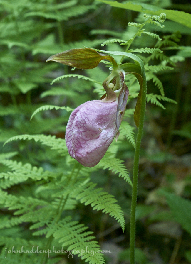
A pink lady’s slipper in the woods
Morning Observation:
This morning in Huntington at 6:55AM it’s currently 59 degrees under low overcast skies. Winds are calm. Relative humidity is 98%, dewpoint 59, barometric pressure 29.83” and steady. We picked up a total of 0.27” of rain over the past 48hrs. Yesterday’s high was 78, and the overnight low was 58.
Forecast:
A cold front sliding down from Canada today will park itself across east-central New York into Massachusetts and remain in place for most of the upcoming week. Some rain showers should linger across southern Vermont today, but skies will trend partly sunny locally with light north to northwesterly winds. Valley highs today should be in the low to mid 70s. Weak high pressure will build in tonight bringing dry and seasonable conditions tonight into Wednesday. The next widespread rainfall is not expected until Thursday or Friday as low pressure approaches from the Ohio River valley.
We’ll see clouds giving way to partly sunny skies today with a slight chance of morning showers south. Highs will be near 73 with light northwest winds. Tonight should be partly cloudy with a low around 52 and light north winds.
Monday should be sunny with a high near 78 and northwest winds 3 to 8 mph. Monday night should be partly cloudy with a low around 53 ad calm winds.
Tuesday’s looking partly sunny with a high near 79 and calm winds becoming northwesterly around 5 mph in the afternoon. Tuesday night should be partly cloudy with a low around 55 and calm winds.
Almanac:
Last year on this date we had a high of 81 and a low of 46. We picked up 0.02″ of rain.
Burlington averages for this date are a low of 56 and highs of 77.
The record low was 37 un 1961.
The record high was 93 in 1981.
Sky Notes:
Sunrise: 5:07AM
Sunset: 8:38PM
Length of day: 15:30:47
Today will be 0:23 longer than yesterday.
The Moon is waxing gibbous, 13.7 days old with 98% illumination.
Moonrise: 8:03PM
Moonset: 4:41AM
About Today’s Photo:
I’ve spotted two pink lady’s slippers on the trails where I run in the mornings. One where I’ve seen it before, and the second in a new location. This native orchid prefers acid soils and you’ll find it in partially shaded woodlands near conifers. The blooms seem to last a long time as I’ve seen this particular blossom for the past two weeks running by. As will all native orchids in Vermont, the flowers are protected, so if you see one, take a picture, but leave it be!
Panasonic GM5, Lumix 12-32mm lens @ 24mm, ISO 1600, f/5.6, 1/200″ exposure.
Friday, June 14, 2019


A broadwing hawk stares me down
Morning Observation:
This morning in Huntington at 6:35AM it’s currently 58 degrees under mostly cloudy skies. Winds are out of the south at 0-5 mph. Relative humidity is 86%, dewpoint 54, barometric pressure 29.65” and steady. We picked up 0.02” of rain in the past 24hrs. Yesterday’s high was 62, and the overnight low was 52.
Forecast:
An upper-level low pressure system across southeastern Ontario this morning will track slowly eastward across the North Country today. bringing variably cloudy skies and scattered light showers. Temperatures will be below normal for mid-June with daytime highs in the 60s. High pressure will briefly build across the region tonight. On Saturday, a cold front north of the International Border will bring breezy south to southwest winds along with increasing chances for showers Saturday afternoon across northern New York, and eventually across Vermont Saturday night into early Sunday morning.
Today should be mostly cloudy with showers likely this afternoon. Highs will be near 66 with southwest winds 10 to 16 mph. Chance of precipitation is 60% with rainfall amounts of less than 1/10″ expected. Tonight should be mostly cloudy with a 30% chance of showers. Skies should gradually clear overnight with a low around 53 and southwest winds around 8 mph.
Saturday should be partly sunny with a 20% chance of showers in the afternoon. Highs will be near 74 with south winds 13 to 17 mph gusting to 28 mph. Saturday night showers are likely. Lows will be around 58 with southwest winds 7 to 16 mph. Chance of precipitation is 80% with rainfall amounts between 1/10″-1/4″ possible.
Sunday’s looking cloudy with a 30% chance of showers. Highs will be near 74 with calm winds becoming northwesterly around 6 mph in the afternoon. Sunday night should be mostly cloudy with a low around 54 and calm winds.
Almanac:
Last year on this date we had a high of 65 and a low of 54. We picked up 0.15″ of rain.
Burlington averages for this date are a low of 55 and a high of 76.
The record low was 39 in 1970.
The record high was 94 in 1988.
Sky Notes:
Sunrise: 5:07AM
Sunset: 8:37PM
Length of day: 15:29:56
Today will be 0:32 longer than yesterday.
The Moon is waxing gibbous, 11.6 days old with 89% illumination.
Moonrise: 5:50PM
Moonset: 3:32AM
About Today’s Photo:
Yesterday morning I heard a bit of bird chatter ruckus over by the brook. The chickadees were making their alarm calls, and the pair of hairy woodpeckers nesting in the poplar snag by the brook were alarmed as well. Looking about, I finally noticed the cause of all the tumult—a broadwing hawk in a dead elm above the brook. It was quite patient, allowing me to get some good shots from the balcony on the second floor of our house. After a few minutes, a robin flew in and chased the hawk into the woods.
Panasonic GX8, Lumix 100-300mm lens @ 200mm, ISO 800, f/5.6, 1/200″ exposure.
Thursday, June 13, 2019

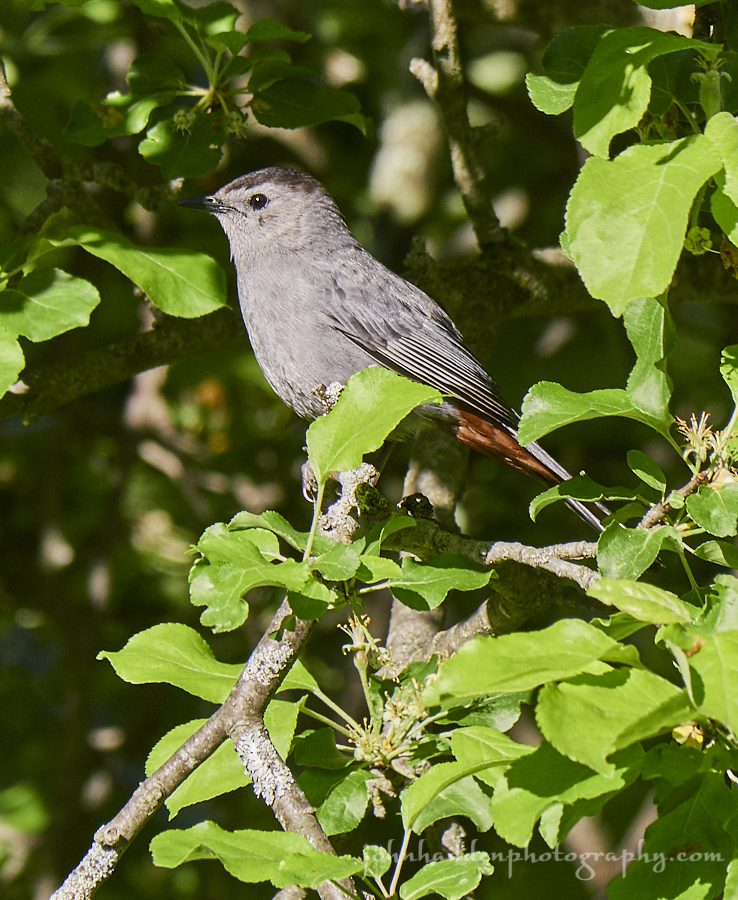
A grey catbird hunts for insects in one of our backyard apple trees
Morning Observation:
This morning in Huntington at 5:50AM it’s currently 52 degrees under overcast skies. Winds are calm. Relative humidity is 96%, dewpoint 50, barometric pressure 29.97” and falling. Yesterday’s high was 76, and the overnight low was 51.
Forecast:
Surface low pressure approaching from the Great Lakes this morning will track slowly northeastward today bringing scattered showers to the region by later this morning and through the day today. A secondary coastal low will reinvigorate showers Friday. A series of troughs will move across the region Saturday and Sunday bringing occasional showers through Monday. Temperatures will be on the cool side today and Friday and warm back to normal levels by Saturday.
We’ll see cloudy skies today with a 50% chance of showers by noon. Highs will be near 65 with southeast winds 5 to 11 mph gusting to 22 mph. Rainfall amounts of less than 1/10″ are expected. Tonight should be cloudy with a 50% chance of showers. Lows will be around 48 with light southeast winds becoming southerly 5 to 9 mph after midnight. Rainfall amounts of less than 1/10″ are expected.
Friday should be partly sunny with a 50% chance of showers. Highs will be near 68 with southwest winds around 11 mph. Friday night should be mostly cloudy with a 30% chance of showers. Lows will be around 51 with south winds around 7 mph.
Saturday’s looking partly sunny with a high near 75 and southwest winds 10 to 17 mph. Saturday night should be mostly cloudy with showers likely. Lows will be around 57 with southwest winds 6 to 8 mph. Chance of precipitation is 60% with rainfall amounts of less than 1/10″ expected.
Almanac:
Last year on this date we had a high of 81 and a low of 53.
Burlington averages for this date are a low of 55 and a high of 76.
The record low was 42 in 1970.
The record high was 94 in 1949.
Sky Notes:
Sunrise: 5:07AM
Sunset: 8:36PM
Length of day: 15:29:24
Today will be 0:36 longer than yesterday.
The Moon is waxing gibbous, 10.6 days old with 81% illumination.
Moonrise: 4:39PM
Moonset: 3:02AM
About Today’s Photo:
Grey catbirds are among my favorite birds. These members of the mockingbird family have quite the ear for songs, and you’ll often here in their babbling calls snippets of other birds’ songs that the catbird has picked up. Of course the catbird’s distinctive “meow” call is what gives it its name.
Panasonic GX8, Lumix 100-300mm lens @ 300mm, ISO 800, f/8, 1/500″ exposure.
Wednesday, June 12, 2019


A clearwing hummingbird moth feeds at the azalea by the side of our house.
Morning Observation:
This morning in Huntington at 6:45AM it’s currently 45 degrees under clear skies. Winds are calm. Relative humidity is 98%, dewpoint 45, barometric pressure 30.16” and rising rapidly. We picked up 0.09” of rain in the past 24hrs. Yesterday’s high was 65, and the overnight low was 42.
Forecast:
We’ve got a lovely day on tap today courtesy of high overhead this morning. We’ll see mostly sunny skies and comfortable temperatures in the mid 70s. Low pressure moving into the Great Lakes this afternoon will bring clouds tonight and rain showers and cooler temperatures Thursday. A secondary coastal low will enhance chances for rain Friday going into the weekend with unsettled weather and below normal temperatures will expected.
We’ll see sunny skies today with a high near 76 and southwest winds 3 to 7 mph. Tonight should be mostly clear with a low around 51 and south winds around 8 mph.
Thursday showers are likely in the afternoon. It’ll be seasonably cool with highs near 63 and southeast winds 7 to 16 mph. Chance of precipitation is 70% with rainfall amounts of less than 1/10″ expected. Thursday night should be cloudy with a 50% chance of showers. Lows will be around 51 with light and variable winds becoming southerly 5 to 7 mph after midnight. Rainfall amounts of less than 1/10″ are expected.
Friday should be cloudy with showers likely. Highs will be near 66 with south winds 10 to 13 mph. Chance of precipitation is 70% with rainfall amounts between 1/10″-1/4″ possible. Friday night should be mostly cloudy with a 30% chance of showers. Lows will be around 50 with west winds 3 to 7 mph.
Almanac:
Last year on this date we had a high of 81 and a low of 40.
Burlington averages for this date are highs of 75 and lows of 54.
The record low was 40 in 1950.
The record high was 94 in 2017 (we had a high of 90).
Sky Notes:
Sunrise: 5:07AM
Sunset: 8:36PM
Length of Day: 15:28:48
Today will be 0:40 longer than yesterday.
The Moon is waxing gibbous, 9.5 days old with 72% illumination.
Moonrise: 3:28PM
Moonset: 2:34AM
About Today’s Photo:
Clearwing hummingbird moths are fascinating little creatures. At first glance, you may think that you’re looking at a baby hummingbird, as the flight characteristics and feeding habits are quite similar to their avian cousins. However, on closer inspection, you’ll see that this little guy uses a proboscis instead of a beak to lap up nectar from flowers. You’ll see these agile little moths in the company of many other pollinators this time of year so keep an eye out.
Panasonic GX8, Lumix 100-300mm lens @ 250mm, ISO 800, f/8, 1/2000″ exposure.
Tuesday, June 11, 2019


Bearded iris blooming in our back garden
Morning Observation:
This morning in Huntington at 7:00AM it’s currently 65 degrees under overcast skies. Winds are calm. Relative humidity is 97%, dewpoint 64, barometric pressure 29.71” and steady. We picked up 0.58” of rain in the past 24hrs. Yesterday’s high was 83, and the overnight low was 64.
Forecast:
Rain showers will quickly end from west to east this morning across the region with clearing skies by this afternoon. High pressure building into the region tonight will bring cool overnight temperatures with lows in the lower 40s. Wednesday should be a lovely day with sunshine and mild temperatures in the mid 70s. Low pressure heading our way from the Great Lakes on Thursday will bring another round of showers Thursday into the upcoming weekend as unsettled weather returns along with cooler temperatures.
We’ll see shower likely this morning with cloudy skies. Showers should move east by midday with clearing skies. Highs will be near 69 with southwest winds 9 to 17 mph becoming northwesterly in the afternoon and gusting to 30mph. Chance of morning precipitation is 70% with rainfall amounts between 1/10″-1/4″ possible. Tonight
should be mostly clear with a low around 47 and northwest winds 5 to 9 mph becoming calm after midnight.
Wednesday should be sunny with a high near 76 and southwest winds 5 to 7 mph. Wednesday night should be partly cloudy with a low around 48 and south winds around 7 mph.
Thursday should be mostly cloudy wih a 50% chance of showers in the afternoon. Highs will be near 65 with southeast winds 6 to 14 mph. Thursday night should be cloudy with showers likely. Lows will be around 51 with southeast winds 5 to 8 mph gusting to 21 mph. Chance of precipitation is 60% with rainfall amounts between 1/10″-1/4″ possible.
Almanac:
Last year on this date we had a high of 73 and a low of 36.
Burlington averages for this date are highs of 75 and lows of 54.
The record low was 35 in 1972.
The record high was 95 in 2017 (we had a high of 91).
Sky Notes:
Sunrise: 5:07AM
Sunset: 8:35PM
Length of Day: 15:28:08
Today will be 0:44 longer than yesterday.
The Moon is waxing gibbous, 8.5 days old with 62% illumination.
Moonrise: 2:17PM
Moonset: 2:06AM
About Today’s Photo:
Beared iris are in bloom in several locations around our house. Drops of rain only enhance their beauty, if not the grape bubblegum scent!
Monday, June 10, 2019


A female hairy woodpecker delivers food to nesting chicks
Morning Observation:
This morning in Huntington at 5:45AM it’s currently 52 degrees under partly cloudy skies. Winds are calm. Relative humidity is 96%, dewpoint 51, barometric pressure 30.15” and falling slowly. Yesterday’s high was 84, and the overnight low was 52.
Forecast:
Well that was a lovely weekend! I hope everyone enjoyed it as much as we did! This morning’s parlty sunny skies will give way to clouds this afternoon out ahead of a low pressure system which moving into the northern Great Lakes this morning. The low will push a cold front through the region late in the day today with widespread rain showers developing from west to east this evening and continuing until Tuesday morning. Behind the departing low, high pressure will build back in Tuesday afternoon bringing drying conditions and partly sunny skies by Tuesday afternoon and continuing into Wednesday night. More showers are expected Thursday night into Friday.
We’ll see partly sunny skies today with clouds moving in this afternoon. Highs will be near 83 with light southeast winds becoming southerly 13 to 18 mph in the afternoon. Tonight should be mostly cloudy with rain likely. Lows will be around 61 with southeast winds 11 to 15 mph. Rainfall amounts between 1/4″-1/2″ are possible.
Tuesday should be cloudy with rain likely in the morning. Skies should gradually clear by midday with a high near 68 and southwest winds 11 to 20 mph becoming northwest in the afternoon and gusting to 31 mph. Chance of precipitation is 70% in the morning with rainfall amounts between 1/4″-1/2″ possible. Tuesday night should be mostly clear with a low around 47 and northwest winds 5 to 9 mph becoming calm after midnight.
Wednesday’s looking sunny with a high near 74 and southwest winds 3 to 7 mph. Wednesday night should be partly cloudy with a low around 52 and south winds 3 to 5 mph.
Almanac:
Last year on this date we had a high of 70 and a low of 38.
Burlington averages for this date are highs of 75 and lows of 54.
The record low was 40 in 1975.
The record high was 93 in 2008 (we had a high of 93).
Sky Notes:
Sunrise: 5:07AM
Sunset: 8:35PM
Length of Day: 15:27:23
Today will be 0:48 longer than yesterday.
The Moon is in its first quarter, 7.4 days old with 50% illumination.
Moonrise: 1:04PM
Moonset: 1:38AM
About Today’s Photo:
We have a pair of hairy woodpeckers nesting in a poplar tree snag down by Fargo Brook. I watched as the male and female took turns delivering food to the hidden chicks in the nesting cavity and alternately carrying waste out of the nest and flying it away. This is the same snag where I observed the chickadee pair excavating a nest earlier this spring. Their hole was about 3′ higher up the snag. I didn’t see any sign of them, however.
Panasonic GX8, Lumix 100-300mm lens @ 300mm.
Friday, June 7, 2019


A common yellowthroat warbler out by our pond
Morning Observation:
This morning in Huntington at 6:30AM it’s currently 43 degrees under clear skies. Winds are calm. Relative humidity is 97%, dewpoint 97, barometric pressure 29.93” and rising slowly. Yesterday’s high was 73, and the overnight low was 42.
Forecast:
We’ve got a lovely weekend on tap courtesy of high pressure currently building into the region. We`ll see mainly dry and sunny conditions with warming temperatures each day reaching the low 80s by Sunday. The next chance for rain arrives later Monday into Monday night with another weak frontal passage. Enjoy the weekend!
We’ll see sunny skies today with a high near 77 and calm winds becoming westerly 5 to 8 mph in the morning. Tonight should be mostly clear with a low around 47 and northwest winds 5 to 7 mph becoming calm in the evening.
Saturday should be sunny with a high near 74 and northwest winds 6 to 9 mph. Saturday night should be mostly clear with a low around 46 with light and variable winds.
Sunday’s looking sunny with a high near 83 and calm winds becoming southwesterly 5 to 7 mph in the afternoon. Sunday night should be mostly clear with a low around 57 and light south winds.
Almanac:
Last year on this date we had a high of 71 and a low of 47. We picked up 0.04″ of rain.
Burlington averages for this date are highs of 74 and lows of 53.
The record low was 35 in 1958.
The record high was 94 in 1999.
Sky Notes:
Sunrise: 5:08AM
Sunset: 8:33PM
Length of Day: 15:24:45
Today will be 1:00 longer than yesterday.
The Moon is a waxing crescent, 4 days old with 18% illumination.
Moonrise: 9:25AM
No Moonset
About Today’s Photo:
There’s a pair of common yellowthroat warblers nesting in the bushes between our pond and Fargo Brook. They seem to be a pretty bold pair, allowing me to get in pretty close for a photo.
Panasonic GX8, Lumix 100-300mm lens.
Thursday, June 6, 2019


Rhodies blooming next to our house
Morning Observation:
This morning in Huntington at 7:00AM it’s currently a juicy 58 degrees under overcast skies. Winds are calm. Relative humidity is 98%, dewpoint 57, barometric pressure 29.71” and rising rapidly. We picked up a soaking 0.96” of rain in the past 24hrs. Yesterday’s high was 71, and the overnight low was 58.
Forecast:
Our loooong cool spring may finally be over folks. Any lingering morning rain showers will be coming to an end rapidly this morning as high pressure starts to build in. We can expect plenty of sunshine by afternoon as dry conditions and seasonable temperatures make a welcomed return to the North Country. Warm and dry weather will continue through the weekend with temperatures bumping into the 80s Sunday. The next chance of rainfall arrives early next week.
Any lingering showers should wrap up by mid morning. We’ll see gradually clearing skies today with a high near 71 and north winds 6 to 10 mph. Tonight should be clear with a low around 47 and light and variable winds.
Friday should be sunny with a high near 74 and calm winds becoming westerly around 6 mph in the morning. Friday night should be mostly clear with a low around 49 and calm winds.
Saturday’s looking sunny with a high near 77 and calm winds becoming northerly 5 to 9 mph in the afternoon. Saturday night should be mostly clear with a low around 50 and calm winds.
Almanac:
Last year on this date we had a high of 65 and a low of 47. We picked up 0.02″ of rain.
Burlington averages for this date are highs of 74 and lows of 53.
The record low was 37 in 1971.
The record high was 94 in 1925.
Sky Notes:
Sunrise: 5:08AM
Sunset: 8:32PM
Length of Day: 15:23:44
Today will be 1:04 longer than yesterday.
The Moon is a waxing crescent, 3.1 days old with 10% illumination.
Moonrise: 8:15AM
Moonset: 11:46PM
About Today’s Photo:
The rhodedendrons next to our house are putting on quite the show right now. It seems to be a good year for them, and several that haven’t bloomed in quite some time are loaded with buds just starting to burst.
iPhone XR, Halide app
Wednesday, June 5, 2019


Canada Mayflower blooming in the woods
Morning Observation:
This morning in Huntington at 6:50AM it’s currently 50 degrees and raining lightly under overcast skies. Winds are calm. Relative humidity is 97%, dewpoint 49, barometric pressure 29.84” and rising. We picked up 0.63” of rain in the past 24hrs. Yesterday’s high was 66, and the overnight low was 48.
Forecast:
We’ve got one more damp, rainy, and unseasonably cool day on tap today before we see a welcome change in the weather pattern heading towards the weekend. A stalled frontal boundary lifting through the North Country this morning will bring ligh rain this morning. The rainfall should taper off during the mid morning hours becoming lightly scattered as a low pressure system over the Great Lakes starts moving towards the region. By late afternoon rain showers should start to reinvigorate as the low starts to deepen with the potential for some heavy rain this afternoon and evening. Showers will linger into Thursday morning, but we should see clearing skies by the afternoon with temperatures finally bumping up to seasonal levels in the low to mid 70s by the afternoon. The pattern will then turn quite a bit warmer and drier as high pressure builds in for the weekend with temperatures warming into the low 80s by Sunday. It’s coming!
We’ll see cloudy skies today with showers likely. Highs will be near 67 with light south winds. Chance of precipitation is 60% with rainfall amounts between 1/10″-1/4″ possible. Tonight showers are likely with possible embedded thunderstorms. Some of the storms could produce heavy rainfall. Lows will be around 55 with light and variable winds. Chance of precipitation is 80% with rainfall amounts between 1/2″-3/4″ possible.
Thursday should start out cloudy with a 30% chance of lingering showers in the morning. Clouds should gradual clear, with a high near 70 and northwest winds 6 to 10 mph. Thursday night should be mostly clear with a low around 47 and north winds around 5 mph becoming calm.
Friday’s looking sunny with a high near 75 and light and variable winds becoming northwesterly 5 to 10 mph in the morning. Friday night should be mostly clear with a low around 49 and calm winds.
Almanac:
Last year on this date we had a high of 58 and a low of 47. We picked up 0.18″ of rain.
Burlington averages for this date are highs of 73 and lows of 52.
The record low was 34 in 1910.
The record high was 92 in 1919.
Sky Notes:
Sunrise: 5:08AM
Sunset: 8:32PM
Length of Day: 15:23:44
Today will be 1:04 longer than yesterday.
The Moon is a waxing crescent, 2 days old with 4.3% illumination.
Moonrise: 7:12AM
Moonset: 10:55PM
About Today’s Photo:
Canada mayflower is in bloom now in the woods. This lovely white flower grows in colonies, and there are several spots along one of my morning runs where the forest floor is covered with the bright green leaves and stalked white blossoms.
Tuesday, June 4, 2019

Bleeding hearts blooming in our ornamental garden
Morning Observation:
This morning in Huntington at 6:55AM it’s currently 46 degrees under partly cloudy skies. Winds are calm. Relative humidity is 98%, dewpoint 45, barometric pressure 30.03” and rising slowly. We picked up 0.04” of rain in the past 24hrs and a bit of hail in the late morning yesterday. Yesterday’s high was 59, and the overnight low was 41.
Forecast:
The cool and damp weather pattern that we’ve been “enjoying” has a couple more days in it, but relief is coming for the weekend! High pressure currently over the region this morning has delivered a chilly start to the day. Clouds will be on the increase as a warm front gradually lifts northward bringing showers to northern New York and southern Vermont during the afternoon and then widespread light rain overnight tonight into Wednesday. Surface low pressure tracking along the warm front from the Great Lakes will bring more rain Thursday. Temperatures through Thursday will remain on the cool side with daytime highs struggling to make the mid 60s. High pressure will finally build in Friday bringing drying conditions and, get this, seasonably warm temperatures in the mid 70s! Temperatures will continue to climb through the weekend bumping towards the mid 80s Sunday with comfortable humidity levels. So hang in there folks, summer’s on its way!
We’ll see increasing clouds today with a high near 60 and west winds 6 to 9 mph. Tonight should be cloudy with showers likely. Lows will be around 46 with south winds 6 to 9 mph. Chance of precipitation is 60% with rainfall amounts between 1/10″-1/4″ possible.
Wednesday should be cloudy with showers likely in the morning. Highs will be near 65 with light southwest winds. Chance of precipitation is 60% with rainfall amounts between 1/10″-1/4″ possible. Wednesday night should be cloudy with showers likely late. Lows will be around 55 with light and variable winds. Chance of precipitation is 70% with rainfall amounts between 1/10″-1/4″ possible.
Thursday should start out cloudy with showers likely in the morning. Skies should gradually clear with a high near 72 and northwest winds 5 to 13 mph. Chance of precipitation is 60% with rainfall amounts of less than 1/10″ expected. Thursday night should be partly cloudy with a low around 50 and light northwest winds.
Almanac:
Last year on this date we had a high of 58 and a low of 46. We picked up 0.10″ rain.
Burlington averages for this date are highs of 73 and lows of 52.
The record low was 34 in 1910.
The record high was 92 in 1919.
Sky Notes:
Sunrise: 5:09AM
Sunset: 8:31PM
Length of Day: 15:21:30
Today will be 1:12 longer than yesterday.
The Moon is a waxing crescent, 1 day old with 1% illumination.
Moonrise: 6:17AM
Moonset: 9:56PM
About Today’s Photo:
Some of our early cultivars are starting to bloom in our ornamental garden. These lovely bleeding hearts have defied the cool and damp to add a splash of colorful warmth to the garden.
iPhone XR, Halide app.
Monday, June 3, 2019


An eastern tiger swallowtail shortly after emerging from its chrysalis
Morning Observation:
This morning in Huntington at 6:30AM it’s currently 41 degrees under clear skies. Winds are calm. Relative humidity is 97%, dewpoint 40, barometric pressure 29.68” and rising slowly. We picked up 0.27” of rain in the past 24hrs. Yesterday’s high was 71, and the overnight low was 40.
Forecast:
An active weather pattern—along with a continuation of damp and below average temperatures—will be the rule through midweek this week. After a sunny start to the day, a potent upper low will pass to our north today bringing another round of scattered to numerous showers along with cool and breezy conditions this afternoon. The showers may produce small hail and a rumble of thunder. Skies should clear a bit this evening setting us up for a chilly night tonight with the potential for frost in the usual cold pockets of the northern ‘Dacks and NEK. Temperatures will rebound a bit on Tuesday before the next round of showers return late Tuesday into Wednesday. Temperatures should return to near normal with some drying by the end of the latter part of the week.
We’ll see sunny skies this morning with increasing clouds and a 50% chance of showers and thunderstorms this afternoon. Some of the storms could produce small hail. Daytime highs today will be well below seasonal averages—near 57—with west winds 7 to 17 mph. Rainfall amounts of less than 1/10″ are expected with higher amounts possible in thunderstorms. Tonight should be cloudy with 30% chance of showers. Lows will be around 41 with west winds 7 to 10 mph.
Tuesday should start out partly cloudy with increasing clouds and a 20% chance of showers in the afternoon. Highs will be near 61 with west winds 7 to 10 mph. Tuesday night should be cloudy with a 50% chance of showers. Lows will be around 45 with southwest winds around 6 mph becoming light and variable after midnight.
Wednesday should be mostly cloudy with a 50% chance of showers. Highs will be near 67 with south winds 3 to 5 mph. Wednesday night should be mostly cloudy with a 50% chance of showers. Lows will be around 54 with light and variable winds.
Almanac:
Last year on this date we had a high of 76 and a low of 42.
Burlington averages for this date are highs of 73 and lows of 51.
The record low was 33 in 1986.
The record high was 94 in 1919.
Sky Notes:
Sunrise: 5:10AM
Sunset: 8:30PM
Length of Day: 15:20:18
Today will be 1:16 longer than yesterday.
The Moon is new, 29.4 days old with 0% illumination.
Moonrise: 5:31AM
Moonset: 8:51PM
About Today’s Photo:
We were visiting family down in Grafton, VT, yesterday, and we came across this eastern swallowtail butterfly as it had recently emerged from its chrysalis. You can see that it was still in the process of “inflating” its new wings.
iPhone XR
Sunday, June 2, 2019


Korean Mountain Ash blooming in our front yard
Morning Observation:
This morning in Huntington at 6:40AM it’s currently a balmy 59 degrees under mostly cloudy skies. Winds are calm. Relative humidity is 98%, dewpoint 58, barometric pressure 29.64” and falling slowly. We picked up 0.36” of rain overnight. Yesterday’s high was 75, and the overnight low was 57.
Forecast:
Stormy weather is expected today as low pressure moving out of the Great Lakes this morning pushes a strong cold front through the region. Strong to locally severe thunderstorms are possible across the eastern ‘Dacks eastward through Vermont with the main threat being strong and gusty winds. Thunderstorms should exit east into New Hampshire by late this evening with quieter weather expected overnight. Another potent upper level trough will approach the region from the Great Lakes on Monday bringing daytime showers and maybe a rumble of thunder on Monday. Temperatures will be on the seasonably cool side Monday, and with an anomolous pool of cool air aloft, some of the storms may contain graupel or small hail. High pressure will build in briefly for Tuesday bringing drier but seasonably cool conditions, before another warm front brings showers on Wednesday. By late in the week we could see some locations approach 80 degrees as an upper level ridge begins to build across the region.
We’ll see mostly cloudy skies today with an 80% chance of showers and thunderstorms. Some storms could produce gusty winds and heavy rain. Highs will be near 72 with light southeast winds becoming southerly 11 to 16 mph in the morning and gusting to 26 mph. Rainfall amounts between 1/4″-1/2″ are possible. Tonight showers and thunderstorms are likely before midnight, diminishing to a slight chance of showers before dawn. It’ll be mostly cloudy, then gradually become mostly clear, with a low around 47 and southwest winds 8 to 11 mph. Chance of precipitation is 60% with rainfall amounts between 1/10″-1/4″ possible with higher amounts possible in thunderstorms.
Monday should be partly sunny with showers likely and thunderstorms possible after 4:00pm. Highs will be near 58 with west winds around 9 mph. Chance of precipitation is 60% with rainfall amounts of less than 1/10″ expected with higher amounts possible in thunderstorms. Monday night showers are likely. It’ll be mostly cloudy with a low around 41 and west winds around 9 mph. Chance of precipitation is 60% with rainfall amounts of less than 1/10″ expected.
Tuesday’s looking mostly sunny and cool with a high near 62 and west winds 9 to 11 mph. Tuesday night should be mostly cloudy with showers likely. Lows will be around 48 with south winds 3 to 7 mph. Chance of precipitation is 70% with rainfall amounts between 1/10″-1/4″ possible.
Almanac:
Last year on this date we had a high of 72 and a low of 50. We picked up 0.09″ of rain.
Burlington averages for this date are highs of 72 and lows of 51.
The record low was 36 in 2003 (we had a low of 36).
The record high was 89 in 1970.
Sky Notes:
Sunrise: 5:10AM
Sunset: 8:29PM
Length of Day: 15:19:02
Today will be 1:19 longer than yesterday.
The Moon is a waning crescent, 28 days old with 1.6% illumination.
Moonrise: 4:53AM
Moonset: 7:42PM
About Today’s Photo:
The Korean Mountain Ash in our front yard is in full bloom right now. The bountiful blossoms smell a bit like rotten hay, but they certainly attract pollinators! Looks like we’ll have a good crop of ash berries in the fall and winter for birds to feed on.
iPhone XR
Saturday, June 1, 2019


Rabbit-rabbit!
Morning Observation:
This morning in Huntington at 7:10AM it’s currently a cool 47 degrees under overcast skies. Winds are calm. Relative humidity is 97%, dewpoint 46, barometric pressure 29.85” and rising slowly. Yesterday’s high was 67, and the overnight low was 40.
Forecast:
We’ve got an active weather pattern ahead of us for the weekend. An approaching upper trough of low pressure will spark scattered showers and possible thunderstorms this afternoon. A second, more robust low pressure system arriving from the Great Lakes on Sunday will deliver widespread rain to the North Country Sunday. Another low will swing through on Monday bringing more rain. Temperatures look to be below average through the middle of next week with a gradual warming trend arriving by the end of the week. The cool and damp continues…
We’ll see mostly cloudy skies today with a 30% chance of showers this afternoon. Highs will be near 72 with light and variable winds. Tonight should be cloudy with a 40% chance of showers. Lows will be around 57 with south winds 5 to 8 mph. Rainfall amounts between 1/10″-1/4″ are possible.
Sunday should be cloudy with an 80% chance of showers. Highs will be near 72 with southwest winds 10 to 13 mph. Rainfall amounts between 1/4″-1/2″ are possible. Sunday night should be cloudy with showers likely. Lows will around 48 with southwest winds 6 to 9 mph. Chance of precipitation is 60% with rainfall amounts between 1/10″-1/4″ possible.
Monday should bring increasing clouds and a 50% chance of showers in the afternoon. It’ll be seasonably chilly with high only near 58 and west winds 5 to 8 mph. Monday night should be mostly cloudy with a 40% chance of showers. Lows will be around 43 with west winds 3 to 7 mph.
Almanac:
Last year on this date we had a high of 86 and a low of 67.
Burlington averages for this date are highs of 72 and lows ow 51.
The record high was 90 in 2013 (we had a high of 88).
The record low was 35 in 1965.
Sky Notes:
Sunrise: 5:11AM
Sunset: 8:28PM
Length of Day: 15:17:42
Today will be 1:23 longer than yesterday.
The Moon is a waning crescent, 27 days old with 5.4% illumination.
Moonrise: 4:21AM
Moonset: 6:34PM
About Today’s Photo:
A eastern cottontail hangs out along the edge of our front field.
