Thursday, December 31, 2015
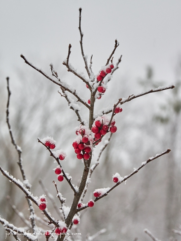
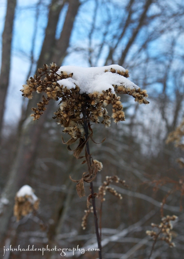
Winterberry holly in yesterday morning’s snow
Morning Observation:
On this last morning of 2015 at 7:15AM it’s currently 33 degrees under overcast skies. Winds are calm. Relative humidity is 98%, dewpoint 33, barometric pressure 30.01”. We picked up 0.22” of rain overnight. Snowpack is down to a soggy 1.5” at the stake. Yesterday’s high was 38, and the overnight low was 33.
Watch out for frozen road surface this morning, especially if you’re heading east of the region towards the Montpelier area.
Have a safe and happy New Years everyone—thanks for reading my blog!
Forecast:
A broad upper level trough will set up over the East Coast today and deliver several rounds of scattered snow showers over the weekend, especially over the higher terrain in the ‘Dacks and Greens. We will see our first brief period of Arctic air Sunday night into Monday with temperatures below normal expected. However temperatures will moderate back to near normal to slightly above
by middle week.
We’ll see mostly cloudy skies with a 20% chance of rain or snow showers today. Highs will be in the mid 30s with west winds around 10 mph. Tonight should be cloudy with a 20% chance of snow showers. Lows will be in the mid 20s with west winds around 10 mph.
Friday should be cloudy with a 30% chance of snow showers. Highs will be in the mid 30s with west winds 10 to 15 mph. Friday night should be cloudy with a 30% chance of snow showers. Lows will be in the lower 20s with west winds 10 to 15 mph.
Saturday’s looking cloudy with a 40% chance of snow showers. Highs in the lower 30s with west winds 10 to 15 mph. Saturday night should be cloudy with a 50% chance of snow showers. Lows will be in the lower 20s.
Almanac:
Last year on this date we had a high of 20 and a low of 8. We had 3″ of snow at the stake.
Burlington averages for this date are highs of 29 and lows of 13.
The record high was 56°F in 1965.
The record low was -19°F in 1963.
Sky Notes:
Sunrise: 7:27 AM EST
Sunset: 4:22 PM EST
Length of Visible Light: 10h 00m
Length of Day: 8h 54m
Tomorrow will be 0m46s longer.
The Moon is waning gibbous, 20d 2h old with 66% illumination. Moonrise: 11:03 PM EST
Moonset: 10:55 AM EST
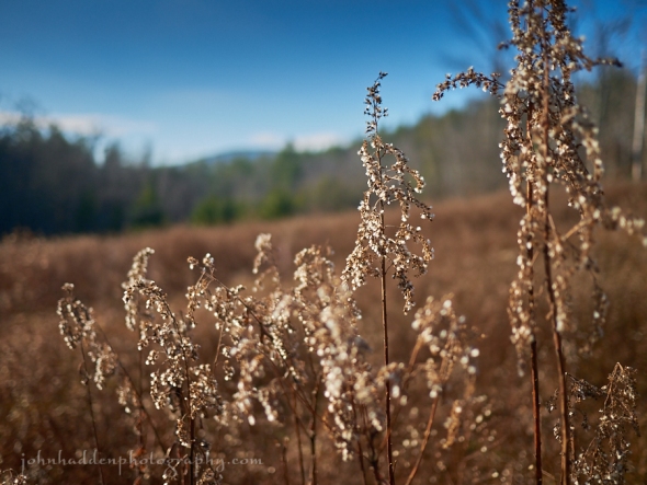
About Today’s Photo:
We have a large winterberry holly bush over by the pond that has a good crop of berries on it this season. Critters have already found it though, as this is a popular food source for a variety of animals.
Panasonic Lumix GM5, Lumix 14-140mm lens @ 46mm, ISO 400, f/4.9, 1/80″ exposure.
Wednesday, December 30, 2015
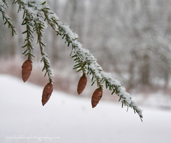
Fresh snow on hemlock cones
Morning Observation:
This morning in Huntington at 7:45AM it’s currently 31 degrees under overcast skies. A spotty of drizzle is coming down. Winds are calm. Relative humidity is 97%, dewpoint 31, barometric pressure 30.25” and rising. We picked up a crusty 0.25” of sleet/rain mix in the past 24hrs and have 3” of snow at the stake. Yesterday’s high was 33, and the overnight low was 31.
Forecast:
A decaying occluded front will deliver spotty light mixed precipitation today. A weak low pressure system will bring a more widespread light wintry mix tonight. Then a series of disturbances will provide for chances of scattered snow showers Thursday into the weekend. Temperatures should be above normal through Thursday and then turn colder to start the New Year.
We’ll see patchy freezing fog this morning. It’ll remain cloudy with a slight chance of rain showers and a chance of snow showers mainly this morning. Highs will be in the mid 30s with light and variable winds, becoming southerly around 10 mph this afternoon. Chance of precipitation is 30%. Tonight snow or rain is likely or a chance of sleet until midnight, then rain likely after midnight. Expect little or no snow or sleet accumulation. Temperatures will remain near steady in the mid 30s with south winds around 10 mph. Chance of precipitation is 60%.
Thursday should be cloudy with a 40% chance of snow or rain showers. Highs will be in the mid 30s with west winds around 10 mph. Thursday night should be cloudy with lows in the mid 20s and west winds around 10 mph.
Friday—New Year’s Day—is looking mostly cloudy with highs in the lower 30s and west winds 10 to 15 mph. Friday night should be mostly cloudy with lows in the lower 20s.
Almanac:
Last year on this date we had a high of 18 and a low of 6. We had 3″ of snow on the ground.
Burlington averages for this date are highs of 29 and lows of 13.
The record high was 51°F in 1990.
The record low was -29°F in 1933.
Sky Notes:
Sunrise: 7:27 AM EST
Sunset: 4:21 PM EST
Length of Visible Light: 10h 00m
Length of Day: 8h 53m
Tomorrow will be 0m43s longer.
The Moon is waning gibbous, 19d 2h old with 75% illumination.
Moonrise: 10:05 PM EST
Moonset: 10:27 AM EST
About Today’s Photo:
It’s finally looking a bit more like the season it is! The hemlock in our side yard has a nice dusting of fresh snow on it this morning.
Panasonic Lumix GM5, Lumix 14-140mm lens @ 34mm, ISO 400, f/4.7, 1/125″ exposure.
Tuesday, December 29, 2015
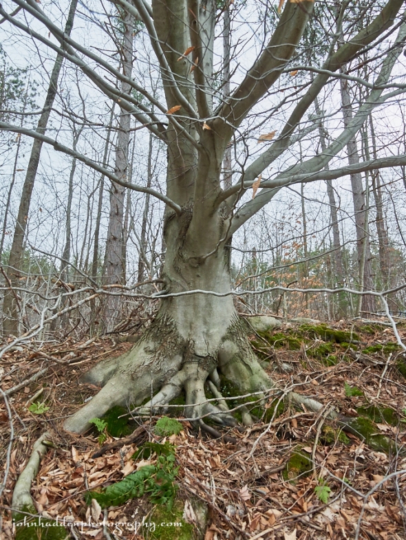
A stately beech along Taft Road
Morning Observation:
This morning in Huntington at 7:15AM it’s currently 22 degrees and sleeting under overcasts skies. Winds are out of the south at 4-6 mph. Relative humidity is 82%, dewpoint 17, barometric pressure 30.26” and falling rapidly. We’ve picked up 2.25” of snow and sleet overnight. Yesterday’s daytime high was 18, and the overnight low was 18.
Winter Weather Advisory remains in effect until 7 PM EST this
evening.
Forecast:
We’re getting our first taste of winter weather this season, and it’s a bit of a messy one. Low pressure will be tracking across lower Michigan and Lake Huron today and into southern Ontario by this evening. Any snowfall will turn to sleet by midmorning with freezing drizzle likely this afternoon to top it all off. We can expect total sleet accumulations of 3″ to 5″ and a trace of ice accumulation. Highs today will top out around 30 with southeast winds 15 to 20 mph gusting up to 35 mph. Chance of precipitation near is 100%. Tonight should be cloudy with lingering freezing drizzle and snow likely until midnight, then a chance of freezing drizzle after midnight. Expect little or no additional snow accumulation and maybe a trace of ice accumulation. Lows will be in the upper 20s with south winds 10 to 15 mph. Chance of precipitation is 70%.
Wednesday should be cloudy with a chance of freezing drizzle in the morning, then a slight chance of rain showers in the afternoon. Highs will be in the upper 30s with south winds around 10 mph. Chance of precipitation is 20%. Wednesday night should be cloudy with a 50% chance of snow or rain as a weak trough slides through. Lows will be in the lower 30s with south winds around 10 mph.
Thursday’s looking cloudy with highs in the mid 30s and west winds around 10 mph. Thursday night should be mostly cloudy with a 40% chance of snow showers as a trough passes to our north. Lows in the mid 20s.
Almanac:
Last year on this date we had a high of 32 and a low of 16. We picked up a trace of new snow and had 3.5″ at the stake.
Burlington averages for this date are highs of 29 and lows of 13.
The record high was 58°F in 1984.
The record low was -29°F in 1933.
Sky Notes:
Sunrise: 7:27 AM EST
Sunset: 4:20 PM EST
Length of Visible Light: 9h 59m
Length of Day: 8h 53m
Tomorrow will be 0m38s longer.
The Moon is waning gibbous, 18d 2h old with 83% illumination.
Moonrise: 9:05 PM EST
Moonset: 9:57 AM EST
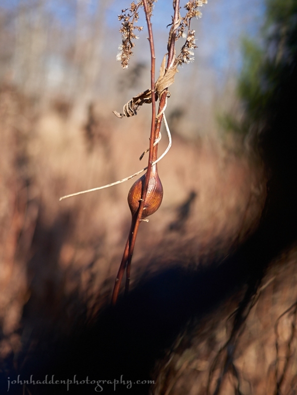
About Today’s Photo:
This stately beech caught my eye the other day walking along Taft Road. The smooth, elephantine bark and tenacious, gripping roots invite a bit of pondering…
Panasonic Lumix GM5, Olympus 9-18mm lens @ 11mm, IOS 400, f/4.7, 1/200″ exposure.
Monday, December 28, 2015
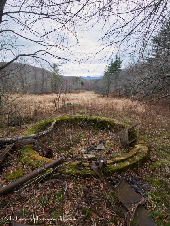
An old silo foundation along the Mailbox Trail
Morning Observation:
This morning in Huntington at 6:40AM it’s currently a 17 degrees under overcast skies. Winds are calm. Relative humidity is 83%, dewpoint 13, barometric pressure 30.48” and rising rapidly. We picked up 0.23” of rain and a 0.50” layer of snow/sleet/graupel. Yesterday’s high was 44, and the overnight low was 17.
There is a Winter Weather Advisory in effect from midnight tonight until 7:00PM Tuesday.
Forecast:
High pressure currently building into the region this morning will provide for seasonably cool and dry conditions today. This will be short-lived, however, as low pressure currently over the Plains moves northeastward and into the region tonight bringing ample moisture. We’ll see snow developing overnight tonight and a mixed bag of wintery precipitation Tuesday. Here comes winter!
We’ll see partly sunny skies today with a 40% chance of snow showers this morning. Highs will only be around 20 with north winds 10 to 15 mph. Tonight should be partly cloudy until midnight, then become cloudy with snow after midnight. Expect snow accumulations of 1″ to 3″ overnight. Lows will be around 13 with light and variable winds, becoming southeasterly 10 to 15 mph and gusting up to 30 mph after midnight. Chance of snow is 90%.
Tuesday will bring snow or sleet in the morning (prepare for a messy commute), then sleet and freezing rain with freezing drizzle likely in the afternoon as temperatures rise. Snow may be heavy at times in the morning. Expect total snow accumulation of 4″ to 6″ along with a trace of ice accumulation. It’ll be breezy with highs in the lower 30s and southeast winds 15 to 25 mph gusting up to 40 mph in our neck of the woods. Chance of precipitation is near 100%. Tuesday night should be cloudy with drizzle and freezing drizzle likely. Lows will be in the lower 30s with south winds 10 to 15 mph.
Wednesday’s looking mostly cloudy and seasonably mild with highs in the upper 30s and light and variable winds. Wednesday night should be mostly cloudy with a 60% chance of rain or snow showers. Expect little or no snow accumulation. Lows will be in the lower 30s.
Almanac:
Last year on this date we had a high of 47 and a low of 33. We had 4″ of snow at the stake.
Burlington averages for this date are highs of 29 and lows of 13.
The record high was 57°F in 1982.
The record low was -16°F in 1933.
Sky Notes:
Sunrise: 7:27 AM EST
Sunset: 4:19 PM EST
Length of Visible Light: 9h 59m
Length of Day: 8h 52m
Tomorrow will be 0m32s longer.
The Moon is waning gibbous, 17d 1h old with 90% illumination. Moonrise: 8:04 PM EST
Moonset: 9:23 AM EST
About Today’s Photo:
This old silo foundation along the Mailbox Trail has always caught my eye. There’s a drywall stone foundation by it as well—the remains of the barn—and a house foundation a couple dozen yards further east. Remnants of the farm that used to be here. The old map of Huntington that we have shows it to be the J.J. Fargo farm. As I walk the woods I often wonder about the farmer who worked this swampy bit of land and laboriously stacked the rocks to form the stone piles and fences I come across…
Panasonic Lumix GM5, Olympus 9-18mm lens @ 9mm, ISO 400, f/11, 1/60″ exposure.
Sunday, December 27, 2015
Recently chewed maple by the beaver pond
Morning Observation:
This morning in Huntington at 8:10AM it’s currently 41 degrees and raining lightly under overcast skies. Winds are calm. Relative humidity is 98%, dewpoint 41, barometric pressure 29.88” and falling rapidly. We picked up 0.26” of rain overnight. Yesterday’s high was 44, and the overnight low was 37.
Forecast:
For all of you awaiting winter, the time has come as the next 48 hours will bring our first real dose of winter weather!
An elongated surface low is located along a tight thermal gradient stretching from the Central Plains to the Ohio Valley and into southern New England. This low will slowly sag southward today bringing in colder air that will change this morning’s rain showers to mixed precipitation and snow later today. We’ll see rain this morning, then rain showers or a chance of snow showers this afternoon. Highs today will be in the lower 40s with temperature falling into the lower 30s this afternoon. Winds will be out of the south winds at around 10 mph, becoming northwesterly this afternoon as the cold air moves in. Chance of precipitation is near 100%. Tonight should be cloudy with a 50% chance of snow showers. Lows will be around 18 with northwest winds 10 to 15 mph gusting up to 30 mph after midnight. We could see total snow accumulations of a dusting to 2″ by Monday morning with higher amounts across mountain summits.
Monday should be partly sunny with a 50% chance of Lake Champlain effect snow showers in the morning, then become sunny in the afternoon as a brief window of chilly high pressure move in. Highs will be around 20 with north winds 10 to 15 mph gusting up to 30 mph in the morning. A more powerful and moisture laden low pressure system will head our way from the Ohio River valley Monday night bringing snow overnight. Expect a few inches on the ground by Tuesday morning and a sloppy commute. Lows will be around 13 with east winds around 10 mph. Chance of snow is 80%.
Snow will continue into Tuesday morning with additional moderate snow accumulations as the low passes and is reinforced by a secondary low off the New England coast. Highs will be around 30 with southeast winds 10 to 15 mph gusting up to 25 mph. Chance of snow is near 100%. Tuesday night snow with freezing drizzle or sleet with possible drizzle is likely as temperatures rise. Expect little or no additional snow accumulation. Lows will be in the upper 20s. Chance of precipitation is 80%. We’re looking at total snow accumulations of 3″-8″ region wide with lesser amounts west of the Champlain Valley.
Almanac:
Last year on this date we had a high of 42 and a low of 30. We had 4″ of snow at the stake.
Burlington averages for this date are highs of 30 and lows of 14.
The record high was 55°F in 1949.
The record low was -23°F in 1968.
Sky Notes:
Sunrise: 7:26 AM EST
Sunset: 4:19 PM EST
Length of Visible Light: 9h 58m
Length of Day: 8h 52m
Tomorrow will be 0m29s longer.
The Moon is waning gibbous, 16d 3h old with 95% illumination.
Moonrise: 7:02 PM EST
Moonset: 8:45 AM EST
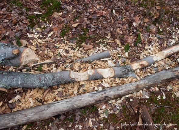
About Today’s Photo:
The beavers have been busy at the Mailbox Trail beaver pond. These recently munched maples create an interesting still life on the forest floor near the water.
Panasonic Lumix GM5, Olympus 9-18mm lens @ 11mm, ISO 400, f/11, 1/50″ exposure.
Saturday, December 26, 2015
The Mailbox Trail beaver pond on Christmas Day
Morning Observation:
This morning in Huntington at 7:10AM it’s currently 26 degrees under mostly clear skies. The full moon is setting in the west and Venus hangs in the southeast. Relative humidity is 96%, dewpoint 25, barometric pressure 20.53” and rising rapidly. Yesterday’s high was 51, and the overnight low was 26.
Forecast:
An active weather pattern is ahead for the next 3 to 5 days with the potential for widespread wintry precipitation Tuesday into Wednesday. We’ll see a cold rain tonight into Sunday with some mixed precipitation likely along the international border. Cool and dry weather is expected on Monday before snow develops on Tuesday morning and changes to a wintry mix by Tuesday evening.
We’ll see sunny skies for most of today. Highs will be in the lower 40s with light and variable winds. Tonight rain or snow is likely mainly after midnight as surface low pressure passes to our south. We may see snow accumulations of a dusting to 1″ in an initial overnight burst before the precipitation turns to rain. Lows will be in the lower 30s with light and variable winds, becoming southeasterly around 10 mph after midnight. Chance of precipitation near is 100%.
Sunday should start out with rain in the morning with rain or snow likely in the afternoon as cold air moves in behind the departing low. Expect snow accumulations of a dusting to 1 inch. Highs will be around 40 with south winds around 10 mph, becoming northwesterly in the afternoon. Chance of precipitation is 90%. Sunday night should be cloudy with a 50% chance of snow showers. Lows will be around 20 with northwest winds 10 to 15 mph.
Monday’s looking partly sunny with highs in the mid 20s and north winds 10 to 15 mph gusting up to 30 mph. Low pressure will approach the region Monday night setting us up for the first significant winter weather event of the season. We should see snow developing overnight and may have accumulations of 4″-6″ by midday on Tuesday. Lows will be around 15. Chance of snow is 80%. Fingers crossed!
Almanac:
Last year on this date we had a high of 58 and a low of 36. We picked up 0.52″ of rain and had 4.75″ of snow at the stake.
Burlington averages for this date are highs of 30 and a low of 14.
The record high was 58°F in 1982.
The record low was -26°F in 1980.
Sky Notes:
Sunrise: 7:26 AM EST
Sunset: 4:18 PM EST
Length of Visible Light: 9h 58m
Length of Day: 8h 51m
Tomorrow will be 0m22s longer.
The Moon is waning gibbous, 15d 1h old with 99% illumination.
Moonrise: 6:01 PM EST
Moonset: 8:00 AM EST
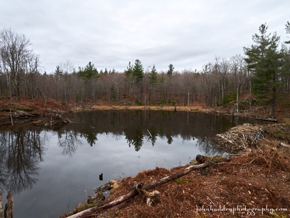
About Today’s Photo:
The Mailbox Trail beaver pond was ice free this Christmas Day. This pond has gone through a lot of changes over the decades, including a dam blowout that drained it several years back. The beavers have been quite busy of late, however, having rebuilt the main dam and constructed several ancillary dams but up- and an downstream of the main pond.
Panasonic Lumix GM5, Olympus 9-18mm lens @ 9mm, ISO 400, f/11, 1/80″ exposure.
Thursday, December 24, 2015
Willow branches, raindrops, reflections at our pond yesterday morning.
Morning Observation:
This morning in Huntington at 7:00AM it’s currently a ridiculous… er, balmy, 55 degrees under overcast skies. Winds are calm. Relative humidity is 91%, dewpoint 53, barometric pressure 29.71” and falling rapidly. We picked up 0.23” of rain overnight along with some very high winds (38mph which is not too far below the 46 mph record for our protected hollow location) that knocked out our power overnight. Yesterday’s high was 59, and the overnight low was 51.
Forecast:
Record high temperatures are expected across the region today with highs mainly in the 60s. The low pressure system that pulled this warm air in—along with some unexpectedly high winds overnight—is currently centered over central Ontario. It will move further northeast and will drag a weak cold front through the region later today. Any lingering morning showers should clear out by midday.
We’ll see cloudy skies with a 40% chance of showers this morning, then partly sunny skies this afternoon. Highs will top out in the mid 60s with southwest winds 15 to 20 mph. Tonight should be mostly clear with lows in the upper 30s and southwest winds 10 to 15 mph gusting up to 25 mph until midnight, then becoming light and variable.
Friday—Christmas day—should be partly sunny as high pressure builds in briefly. Highs will be in the mid 40s and light and variable winds. Friday night should be partly cloudy with lows in the lower 30s and light and variable winds.
Saturday’s looking partly sunny with a 50% chance of rain showers in the afternoon as a warm front lifts our way out ahead of the next low moving in from the Ohio River valley. Highs will be in the lower 40s with light and variable winds. Saturday night rain is likely with a chance of sleet over higher elevations. Expect little or no sleet accumulation. Lows will be in the mid 30s. Chance of precipitation is 70%.
Almanac:
Last year on this date we had a high of 46 and a low of 35. We picked up 0.07″ of rain and had 9.5″ of snow at the stake.
Burlington averages for this date are highs of 30 and lows of 15.
The record high was 51°F in 1941 (that record has already fallen…)
The record low was -18°F 1989.
Sky Notes:
Sunrise: 7:25 AM EST
Sunset: 4:17 PM EST
Length of Visible Light: 9h 58m
Length of Day: 8h 51m
Tomorrow will be 0m14s longer.
The Moon is waxing gibbous, 13d 1h old with 99% illumination.
Moonrise: 4:04 PM EST
Moonset: 6:10 AM EST
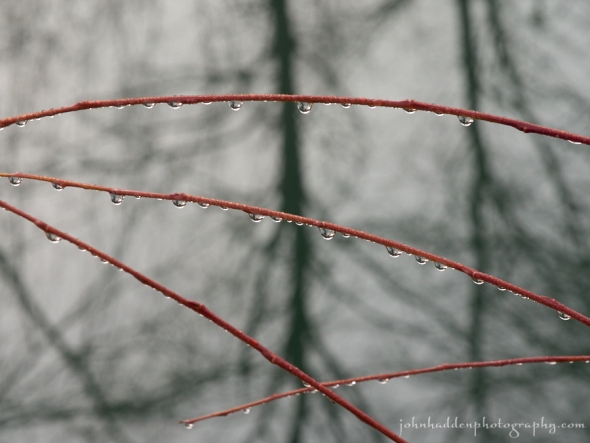
About Today’s Photo:
Raindrops bead on willow branches by the pond yesterday morning.
Panasonic Lumix GM5, Lumix 14-140mm lens @ 109mm, ISO 400, f/16, 1/60″ exposure.
Wednesday, December 23, 2015

Rock ferns, moss, and quartzite up on Delfrate Hill
Morning Observation:
This morning in Huntington at 7:15AM it’s currently 37 degrees under overcast skies. Winds are calm. Relative humidity is 98%, dewpoint 36, barometric pressure 30.14” and rising slowly. We picked up 0.94” of rain in the past 24hrs. Yesterday’s high was 51, and the overnight low was 36.
Forecast:
A strong upper level trough of low pressure currently over the plains states will pull abundant moisture northward from the southeastern U.S. and into the region late this afternoon and tonight. We’ll have a dry day today with rain moving in late this afternoon and overspreading the region tonight.
We’ll see areas of dense fog this morning along with partly sunny this morning, then cloudy skies with a 20% chance of rain this afternoon. Highs will be in the lower 50s with light and variable winds, becoming southerly around 10 mph this afternoon. Tonight will bring rain. Lows will be in the upper 40s with south winds 10 to 15 mph gusting up to 25 mph. Chance of rain is near 100%.
The aforementioned low will move northwest of us Thursday into the James Bay region of Canada. This will set the stage for record-setting warmth to work its way into the region. We’ll see cloudy skies on Christmas Eve with a chance of showers in the morning as a weak cold front slides through, then partly sunny skies with a slight chance of showers in the afternoon. Temperatures will top out in the lower 60s with southwest winds 10 to 15 mph. Chance of rain is 40%. Thursday night should be partly cloudy with lows in the lower 40s and southwest winds around 10 mph.
High pressure will build in for Christmas day bringing partly sunny skies with highs in the mid 40s and west winds around 10 mph. Friday night should be partly cloudy with lows in the lower 30s.
Almanac:
Last year on this date we had a high of 43 and a low of 33. We picked up 0.09″ of rain and had 12″ of snow at the stake.
Burlington averages for this date are highs of 31 and lows of 15.
The record high was 58°F in 1990.
The record low was -18°F in 1955.
Sky Notes:
Sunrise: 7:25 AM EST
Sunset: 4:16 PM EST
Length of Visible Light: 9h 57m
Length of Day: 8h 51m
Tomorrow will be 0m9s longer.
The Moon is waxing gibbous, 12d 2h old with 95% illumination.
Moonrise: 3:12 PM EST
Moonset: 5:05 AM EST
About Today’s Photo:
Quartzite offers a bit of white to set off the greens of rock ferns and mosses.
Panasonic Lumix GM5, Lumix 30mm macro lens, ISO 400, f/7.1, 1/125″ exposure.
Tuesday, December 22, 2015

Still life with deer scapula and moss
Morning Observation:
This morning in Huntington at 8:00AM it’s currently 49 degrees under overcast skies. Winds are calm. Relative humidity is 80%, dewpoint 43, barometric pressure 29.95”. We picked up 0.04” of rain in the past 24hrs. Yesterday’s high was 46, and the overnight low was 40.
Forecast:
Low pressure over the Great Lakes will pull warm moist air into the region today—a trend that will continue into the weekend. We’ll see rain today starting later this morning. Highs will top out in the upper 40s this morning then slide a bit as the rain arrives. Winds will be out of the south at around 10 mph. Chance of rain is near 100%. Tonight will be cloudy with a 40% chance of showers until midnight. Lows will be in the upper 30s with southwest winds around 10 mph until midnight, becoming light and variable.
Wednesday should start out partly sunny in the morning, then become mostly cloudy with a 20% chance of showers in the afternoon. Highs will be in the upper 40s with southeast winds 10 to 15 mph, and gusting up to 30 mph in the afternoon. Wednesday night showers are likely as another low moves our way from the Great Lakes. It’l be breezy and very mild with lows in the mid 40s and southeast winds 20 to 25 mph gusting up to 40 mph. Chance of rain is 70%.
Thursday should set some records for warmth region-wide. It’ll be mostly cloudy with a 40% chance of showers. Highs will be around 60 with south winds 10 to 15 mph gusting up to 25 mph. Thursday night should be partly cloudy with a 50% chance of showers. Lows will be in the lower 40s.
Almanac:
Last year on this date we had a high of 38 and a low of 23. We had 12″ of snow at the stake.
Burlington averages for this date are highs of 31 and lows of 16.
The record high was 57°F in 1990.
The record low was -20°F in 1955.
Sky Notes:
Sunrise: 7:25 AM EST
Sunset: 4:16 PM EST
Length of Visible Light: 9h 57m
Length of Day: 8h 51m
Tomorrow will be 0m4s longer.
The Moon is waxing gibbous, 11d 2h old with 89% illumination.
Moonrise: 2:26 PM EST
Moonset: 3:56 AM EST
About Today’s Photo:
I came across this deer scapula laying in a bed of moss along Fargo Brook. The very definition of “still life”.
Panasonic Lumix GM5, Lumix 14-140mm lens @ 40mm, ISO 400, f/7.1, 1/100″ exposure.
Monday, December 21, 2015: The Winter Solstice
The view of the Huntington Valley from a secluded hay meadow yesterday morning. Note my ski tracks…
Happy Winter Solstice!
Morning Observation:
This morning in Huntington at 7:00AM it’s currently 37 degrees under clear skies. Winds are calm. Relative humidity is 51%, dewpoint 20, barometric pressure 30.14” and falling slowly. We have 1.5” of snow at the stake. Yesterday’s high was 33, and the overnight low was 33.
Forecast:
Our brief taste of winter this past weekend was sweet but will be short-lived. Strengthening surface and upper level high pressure moving off the eastern Seaboard this morning will take residence over Bermuda for the foreseeable future. This will help to set up a a warm south/southwesterly airflow which will dominate our weather with a return of abnormally to record warm temperatures for late December. Showery conditions will be the rule for the upcoming week with record high temperatures in store for Christmas Eve.
This morning’s sunshine will give way to cloudy skies with a 50% chance of rain showers this afternoon as a surface low approaches from the southwest. Highs will be in the lower 40s with south winds 10 to 15 mph. Tonight should be cloudy with a 50% chance of rain showers, mainly until midnight. Temperatures will remain near steady—in the upper 30s—with south winds 10 to 15 mph gusting up to 25 mph.
Tuesday morning should start out cloudy but dry, with showers arriving in the afternoon. Highs will be in the mid 40s with south winds around 10 mph. Chance of rain is 80%. Tuesday night should be partly cloudy with a 40% chance of showers. Lows will be in the mid 30s with south winds around 10 mph.
Wednesday’s looking partly sunny with a 40 percent chance of showers, mostly in the afternoon. Highs will be in the upper 40s with southeast winds around 10 mph. Wednesday night should bring a more persistent slug of rain. Lows will be in the lower 40s. Chance of rain is 80%.
Almanac:
Last year on this date we had a high of 25 and a low of 8. We had 12.5″ of snow at the stake.
Burlington averages for this date are highs of 31 and lows of 16.
The record high was 61°F in 1957.
The record low was -22°F in 1955.
Sky Notes:
Sunrise: 7:24 AM EST
Sunset: 4:15 PM EST
Length of Visible Light: 9h 57m
Length of Day: 8h 51m
Tomorrow will be 1 second longer!
The Moon is waxing gibbous, 10d 1h old with 81% illumination.
Moonrise: 1:45 PM EST
Moonset: 2:46 AM EST
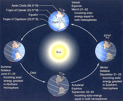
The Winter Solstice occurs tonight at 11:49PM EST. This marks the beginning of astronomical winter for the norther hemisphere, and the shortest day of the year for us. The Winter Solstice occurs at the point in the Earth’s orbit around the sun when the northern hemisphere is tilted the furthest from sun—approximately 23.5 degrees. For folks in the southern hemisphere, this is the first day of summer. Here’s a handy graphic:
You can read more about the Solstice here and here.
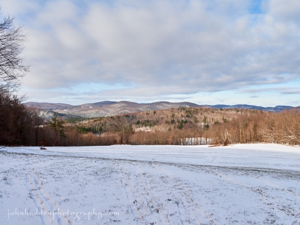
About Today’s Photo:
Yesterday’s brief taste of winter was enough for me to get out the rock skis and head for a favorite hay meadow. There was just enough snow to slide over the grass stubble. When the sun eventually emerged, the view of the Huntington River valley was quite nice.
Panasonic Lumix GM5, Lumix 14-140mm lens @ 14mm, ISO 400, f/16, 1/125″ exposure.
Sunday, December 20, 2015
Actual snow on goldenrod this morning!
Morning Observation:
This morning in Huntington at 8:00AM it’s currently 22 degrees under mostly cloudy skies. Winds are out of the northwest at 0-3 mph. Relative humidity is 79%, dewpoint 17, barometric pressure 30.40”. We picked up 2.25” of snow overnight and have 2.25 at the stake! Looking more seasonable indeed, at least for the short term… Yesterday’s high was 34, and the overnight low was 22.
Forecast:
As a brief ridge of high pressure builds into the region today, any isolated morning snow showers will dissipate with partly sunny to mostly cloudy skies developing this afternoon. Cooler weather continues today as well, with temperatures in the 20s and 30s, but this cool-down will be short lived, as above normal temperatures return for Monday and continue to warm through the week. Beyond today, chances for rain exist most days this week, especially Wednesday and Thursday with record high temperatures expected on Christmas Eve.
We’ll see partly sunny skies today with scattered snow showers this morning. Highs will top out at around 30 with northwest winds 10 to 15 mph. becoming southwesterly this afternoon. Chance of snow is 30%. Tonight should be partly cloudy with lows in the mid 20s and south winds 10 to 15 mph.
A shortwave trough will approach the region Monday (the Winter Solstice) bringing cloudy, warmer temperatures and and a 40% chance of rain showers in the afternoon. Highs will be in the lower 40s with south winds 10 to 15 mph gusting up to 25 mph. Monday night should be mostly cloudy with a 50% chance of rain showers. Lows will be in the upper 30s with south winds 10 to 15 mph gusting up to 25 mph.
Tuesday’s looking cloudy with highs in the mid 40s and south winds around 10 mph. Tuesday night should be cloudy with lows in the mid 30s.
Almanac:
Last year on this date we had a high of 28 and a low of 5. We had 13″ of snow at the stake.
Burlington averages for this date are highs of 32 and lows of 17.
The record high was 62°F in 1957.
The record low was -23°F in 1942.
Sky Notes:
Sunrise: 7:23 AM EST
Sunset: 4:15 PM EST
Length of Visible Light: 9h 57m
Length of Day: 8h 51m
Tomorrow will be 0m5s shorter.
The Moon is waxing gibbous, 9d 2h old with 72% illumination. Moonrise: 1:07 PM EST
Moonset: 1:34 AM EST
About Today’s Photo:
Actual snow! Sure looks pretty out there right now…
Panasonic Lumix GM5, Lumix 14-140mm lens @ 21mm, ISO 400, f/4.7, 1/320″ exposure.
Saturday, December 19, 2015
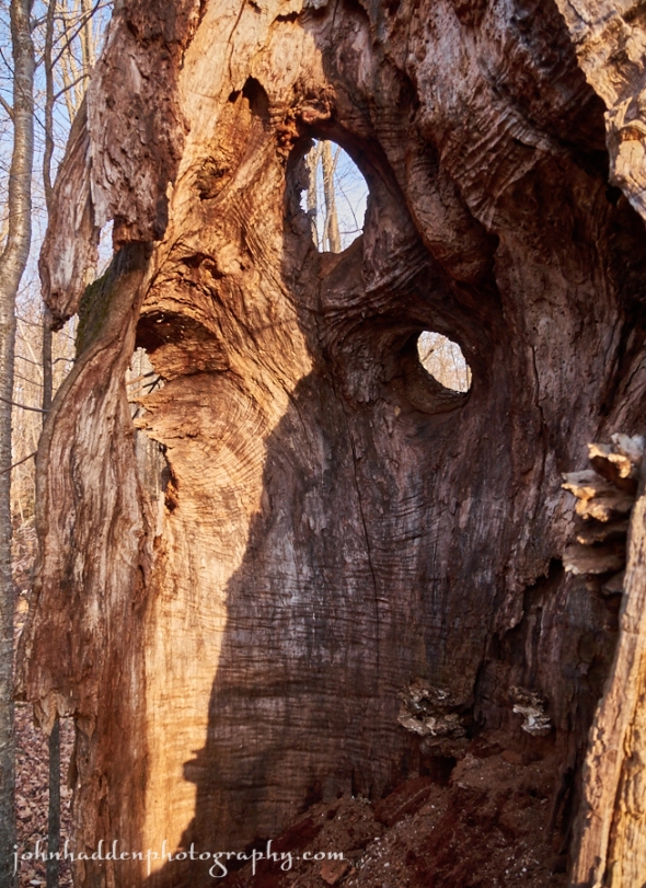
The interior of a large, tumbled-down ash tree conjures up a face to me… You?
Morning Observation:
This morning in Huntington at 7:20AM it’s currently 31 degrees under overcast skies. Winds are out of the west at 0-3 mph. Relative humidity is 71%, dewpoint 22, barometric pressure 29.79” and rising slowly. We picked up a 0.01” trace of rain and a dusting of snow in the past 24hrs. Yesterday’s high was 46, and the overnight low was 30.
Forecast:
An upper level trough building into the northeast today will provide the region with more typical December weather this weekend, with colder temperatures and scattered snow showers, especially this afternoon and evening. Cooler weather will be short lived however, as above normal air returns Monday and temperature warm again through the week along with the threat of rain showers.
We’ll see cloudy skies with scattered snow showers today. Highs will be in the mid 30s with west winds 15 to 20 mph gusting up to 30 mph. Chance of snow is 50%. Tonight should be cloudy with scattered snow showers. It’ll be breezy with lows in the lower 20s and northwest winds 15 to 25 mph gusting up to 40 mph. Chance of snow is 50%. We can expect a dusting to and inch in valley locations with up to 3″ on mountain summits. Woo-hoo!
Surface high pressure will build in for Sunday bringing partly sunny skies. Highs will be around 30 with northwest winds 10 to 15 mph gusting up to 25 mph and becoming southwesterly in the afternoon. Sunday night should be mostly cloudy with lows in the upper 20s and south winds 10 to 15 mph.
Another El Niño driven Pacific system will ride its way on the jet stream into our region Monday bringing cloudy skies, unseasonably warm temperatures and a 30% chance of rain showers. Highs will be in the lower 40s with south winds 10 to 15 mph gusting up to 25 mph. Monday night should be mostly cloudy with a 40% chance of showers. Lows will be around 40.
At this point, it’s looking like warm temps and rain straight through Christmas and beyond folks. The white Christmas we may be dreaming of is not in the cards this time around the sun…
Almanac:
Last year on this date we had a high of 27 and allow of 13. We picked up 0.50″ of new snow and had 13″ at the stake.
Burlington averages for this date are highs of 32 and lows of 17.
The record high was 49°F in 1895.
The record low was -16°F in 1942.
Sky Notes:
Sunrise: 7:23 AM EST
Sunset: 4:14 PM EST
Length of Visible Light: 9h 58m
Length of Day: 8h 51m
Tomorrow will be 0m9s shorter.
The Moon is waxing gibbous, 8d 2h old with 60% illumination. Moonrise: 12:33 PM EST
Moonset: 12:24 AM EST
About Today’s Photo:
I came across a huge, tumbled-down and rotting ash tree while rambling in the hills northeast of our house the other day. The interior cavity of the trunk was a good 3′ across, and the splayed limbs reached out over 100′ laying along the ground. I found the interior of the stump quite fascinating with its numerous folds and wrinkles. I see a face. How about you?
Panasonic Lumix GM5, Lumix 14-140mm lens @ 14mm, ISO 400, f/4.3, 1/100″ exposure.
Friday, December 18, 2015
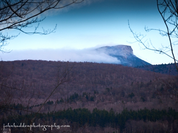
Camel’s Hump seems to smolder in the afternoon light in this view from Delfrate Road
Morning Observation:
This morning in Huntington at 7:15AM it’s currently 38 degrees under overcast skies. Winds are calm. Relative humidity is 84%, dewpoint 34, barometric pressure 29.74” and rising. We picked up 0.28” of rain in the past 24hrs. Yesterday’s high was 49, and the overnight low was 38.
Forecast:
As low pressure which brought widespread rain to the region over the last 24 hours continues to shift to the east off the New England coast today, relatively quiet but cloudy conditions are expected to end the work week. Mild temperatures continue today as well, but a brief cool down is in the forecast for the weekend along with some scattered snow showers for Saturday as a modestly deep longwave trough traverses the region.
We’ll see cloudy skies today with a 20% chance of drizzle this morning. Highs will be in the upper 30s with northwest winds around 10 mph. Tonight should be cloudy with a 20% chance of snow showers after midnight. Lows will be in the mid 20s with northwest winds 10 to 15 mph.
Saturday should be cloudy with a 50% chance of snow showers mainly in the afternoon. Highs will be seasonable—in the lower 30s—with west winds 10 to 15 mph gusting up to 30 mph. Saturday night Should be cloudy with a 50% chance of snow showers. Lows will be in the lower 20s with northwest winds 15 to 20 mph gusting up to 35 mph.
A ridge of high pressure will nose its way in on Sunday bringing partly sunny skies and cooler temperatures. Highs will be in the upper 20s with west winds around 10 mph. Sunday night should be partly cloudy with lows in the upper 20s.
Almanac:
Last year on this date we had a high of 33 and a low of 27. We picked up 0.15″ of rain, 0.50″ of new snow and had 13″ of snow at the stake.
Burlington averages for this date are highs of 32 and lows of 17.
The record high was 57°F in 1921.
The record low was -13°F in 1919.
Sky Notes:
Sunrise: 7:22 AM EST
Sunset: 4:14 PM EST
Length of Visible Light: 9h 58m
Length of Day: 8h 51m
Tomorrow will be 0m14s shorter.
The Moon is in its first quarter, 7d 1h old with 49% illumination.
Moonrise: 12:00 PM EST
No Moon Set
About Today’s Photo:
Another side of Camel’s Hump. The summits seems to smolder in the afternoon light as clouds pull away on a southerly airflow.
Panasonic Lumix GM5, Lumix 14-140mm lens @ 140mm, ISO 400, f/5.6, 1/200″ exposure.
Thursday, December 17, 2015

One of several of the small waterfalls on Fargo Brook upstream from our place
Morning Observation:
This morning in Huntington at 7:20AM it’s currently a balmy 45 degrees under overcast skies. Winds are out of the south at 3-5 mph. Relative humidity is 81%, dewpoint 39, barometric pressure 29.94” and falling. We picked up a 0.01” trace of melted precipitation in the the past 24hrs from the nearly persistent snizzle we had during most of the day yesterday. Yesterday’s high was 40, and the overnight low was 40.
Forecast:
A low pressure system shifting north from the Great Lakes to James Bay will bring widespread rain showers to the region through tonight with temperatures remaining well above normal. Generally quiet weather follows for Friday and the weekend outside of some
scattered higher elevation snow showers. Temperatures will remain relatively mild for middle to late December.
We’ll see cloudy skies today with rain likely mainly this afternoon. Highs will be in the upper 40s with south winds 15 to 20 mph. Chance of rain is 90%. Tonight rain is likely. Lows will be in the mid 30s with south winds around 10 mph, becoming northwesterly after midnight. Chance of rain is 90%.
Friday should be cloudy with a 20% chance of rain or snow showers in the morning. Highs will be in the upper 30s with light and variable winds. Friday night should be cloudy with lows in the mid 20s and northwest winds around 10 mph.
Saturday’s looking cloudy with a 50% chance of snow showers. Highs will be more seasonable—in the lower 30s—with west winds 10 to 15 mph gusting up to 25 mph. Saturday night should be mostly cloudy with a 50% chance of snow showers. Lows will be in the mid 20s.
Almanac:
Last year on this date we had a high of 35 and a low of 33. We picked up 0.05″ of rain and had 13″ of snow at the stake.
Burlington averages for this date are highs of 33 and lows of 18.
The record high was 56°F in 2000 (we had high of 54).
The record low was -11°F in 2013 (we had a low of -14).
Sky Notes:
Sunrise: 7:22 AM EST
Sunset: 4:13 PM EST
Length of Visible Light: 9h 58m
Length of Day: 8h 51m
Tomorrow will be 0m19s shorter.
The Moon is a waxing crescent, 6d 2h old with 38% illumination.
Moonrise: 11:26 AM EST
Moonset: 11:14 PM EST
About Today’s Photo:
Fargo Brook has several small waterfalls and sluices upstream from our house. Some have been filled in by gravel or stuffed with branches, trees, and other flotsam. This one’s still flowing!
Panasonic Lumix GM5, Lumix 14-140mm lens @ 15mm, circular polarizing filter, ISO 200, f/20, 2″ exposure.
Wednesday, December 16, 2015

A cache of acorns beneath a red oak on Delfrate Hill
Morning Observation:
This morning in Huntington at 7:00AM it’s currently 33 degrees under overcast skies. Winds are calm. Relative humidity is 96%, dewpoint 32, barometric pressure 30.13” and rising rapidly. We picked up 0.12” of rain in the past 24hrs and a dusting of sleet overnight. Yesterday’s high was 57, and the overnight low was 33.
Forecast:
High pressure currently building into the region will have a tough time scouring out the clouds today, but we can expect dry weather today. A trough of low pressure will move into eastern Canada and the northeast United States Thursday and Thursday night and bringing more rain to the region Mostly cloudy.
Today will be cloudy with highs around 40 and light and variable winds. Tonight should be partly cloudy with lows in the lower 30s and southeast winds 10 to 15 mph.
Thursday should be cloudy with rain likely mainly in the afternoon as the aforementioned trough move in. Highs will be in the mid 40s with south winds 10 to 15 mph gusting up to 25 mph. Chance of rain is 80%. Thursday night rain is likely. Lows will be in the upper 30s with southwest winds 10 to 15 mph. Chance of rain is 90%.
Friday’s looking mostly cloudy with a 40% chance of rain showers. Highs will be in the lower 40s with light and variable winds. Friday night should be mostly cloudy with scattered snow showers over higher elevations. Lows will be in the mid 20s. Chance of snow is 30%.
Almanac:
Last year on this date we had a high of 36 and a low of 18. We had 14.5″ of snow at the stake.
Burlington averages for this date are highs of 33 and lows of 18.
The record high was 54°F in 1982.
The record low was -18°F in 1917.
Sky Notes:
Sunrise: 7:21 AM EST
Sunset: 4:13 PM EST
Length of Visible Light: 9h 58m
Length of Day: 8h 52m
Tomorrow will be 0m23s shorter.
The Moon is a waxing crescent, 5d 1h old with 27% illumination.
Moonrise: 10:52 AM EST
Moonset: 10:04 PM EST
About Today’s Photo:
With no snow on the ground, it’s easy to see the handiwork of critters in the woods as they make ready for winter. This cache of munched acorn (with one remaining) was in a pile at the foot of a large red oak on the side of Delfrate Hill.
Panasonic Lumix GM5, Lumix 30mm macro lens, ISO 400, f/7.1, 1/13″ exposure.
Tuesday, December 15, 2015
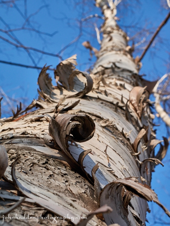
Bark curls on a birch on Delfrate Hill
Morning Observation:
This morning in Huntington at 7:55AM it’s currently 47 degrees and drizzling lightly under mostly cloudy skies. Winds are calm. Relative humidity is 98%, dewpoint 46, barometric pressure 29.33”. We picked up 0.31” of rain overnight. Yesterday’s high was 58, and the overnight low was 46.
Forecast:
The upper level trough of low pressure that brought overnight rains will move east of the region this afternoon bringing showers to a halt later today. High pressure will build into the region tonight and Wednesday for dry weather, but the dry period will be short lived as another upper level trough moves into the northeast Thursday into Friday bringing more rain. Today will be the warmest day of the week and, although high temperatures will be cooler in the coming days, they will remain above normal.
We’ll see cloudy skies with scattered showers today. Highs will be around 50 with west winds 15 to 20 mph gusting up to 30 mph. Chance of rain is 50%. Tonight should be mostly cloudy with a 30% chance of rain showers until midnight. Lows will be in the lower 30s with northwest winds 10 to 15 mph gusting up to 30 mph until midnight.
Wednesday should be partly sunny with highs in the lower 40s and light and variable winds. Wednesday night should be partly cloudy with lows in the lower 30s and southeast winds around 10 mph.
The aforementioned trough of low pressure will move into the region Thursday bringing more rain. Highs will be in the mid 40s with south winds 10 to 15 mph. Chance of rain is 70%. Thursday night rain is likely. Lows will be in the upper 30s. Chance of rain is 70%.
Curious about this warm weather? I did a bit of digging this morning and found that, while El Niño is contributing to the warm conditions over most of the US, a more prominent cause is the Arctic Oscillation (a.k.a the “Polar Vortex”). The AO is the change in air pressure at the North Pole that affects how far south cold air travels from the Arctic. Currently, air pressure over the Arctic is low, or in a strongly “positive” phase, meaning that the cold air remains locked up in the Arctic. Last winter we experienced long periods of “negative” phase which brought lots of cold air into the southern US. Forecasting the weather in these days of climate change is tricky business, especially when combined with the strongest El Niño on record. We’ll just have to wait and see how this winter pans out…
You can read more about how the AO is contributing to our current weather pattern here and here (scientific).
Almanac:
Last year on this date we had a high of 30 and a low of 27. We had 15″ of snow at the stake.
Burlington averages for this date are highs of 33 and lows of 19.
The record high was 62°F in 1901.
The record low was -12°F in 1943.
Sky Notes:
Sunrise: 7:20 AM EST
Sunset: 4:13 PM EST
Length of Visible Light: 9h 59m
Length of Day: 8h 52m
Tomorrow will be 0m29s shorter.
The Moon is a waxing crescent, 4d 2h old with 18% illumination.
Moonrise: 10:15 AM EST
Moonset: 8:56 PM EST
About Today’s Photo:
Looking up through the curls of bark on a paper birch on Delfrate Hill.
Panasonic Lumix GM5, Lumix 30mm macro lens, ISO 400, f/11, /160″ exposure.
Monday, December 14, 2015
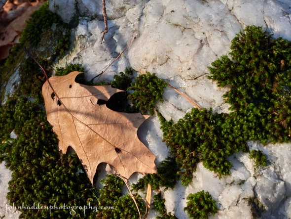
A red oak leaf and moss on quartzite
Morning Observation:
This morning in Huntington at 6:45AM it’s a balmy and blustery 53 degrees under overcast skies. Winds are out of the south at 3-7 mph. Relative humidity is 84%, dewpoint 49, barometric pressure 29.89” and falling rapidly. We picked up a 0.01” trace of rain overnight. Yesterday’s high was 41, and the overnight low was 40.
Forecast:
Not winter continues… An upper level trough of low pressure will approach the region from the Great Lakes tonight and move east of the area on Tuesday. It’ll bring widespread rain to northern New York and Vermont tonight and then taper off as the day progresses on Tuesday. Dry weather returns for Wednesday before another trough of low pressure brings a chance of rain to the area Thursday into Friday. Above normal temperatures will continue for the upcoming work week as well.
We’ll see mostly cloudy skies with a 30% chance of rain this afternoon. Highs will be in the lower 50s with south winds 10 to 15 mph. Tonight will bring widespread rain. Lows will be in the mid 40s with south winds 10 to 15 mph. Chance of rain is near 100%.
Tuesday should be cloudy with showers likely mainly in the morning. Highs will be in the upper 40s with west winds 10 to 15 mph, becoming northwesterly with gusts up to 25 mph in the afternoon. Chance of rain is 60%. Tuesday night should be mostly cloudy with lows in the lower 30s and northwest winds around 10 mph.
Wednesday’s looking mostly sunny with highs in the lower 40s and light and variable winds. Wednesday night should be partly cloudy with lows in the lower 30s.
Almanac:
Last year on this date we had a high of 35 and a low of 26. We had 17″ of snow at the stake. Our power finally came back on at 7:30PM.
Burlington averages for this date are highs of 34 and lows of 19.
The record high was 63°F in 1901.
The record low was -11°F in 1933.
Sky Notes:
Sunrise: 7:19 AM EST
Sunset: 4:13 PM EST
Length of Visible Light: 9h 59m
Length of Day: 8h 53m
Tomorrow will be 0m32s shorter.
The Moon is a waxing crescent, 3d 1h old with 10% illumination.
Moonrise: 9:34 AM EST
Moonset: 7:50 PM EST
About Today’s Photo:
The closest thing we’re getting to what looks anything like snow in the woods right now… This quartzite boulder glows white out of the leaf litter of the forest floor, sporting a beard of moss and a red oak leaf accessory.
Panasonic Lumix GM5, Lumix 30mm macro, ISO 400, f/8, 1/125″ exposure.
Sunday, December 13, 2015
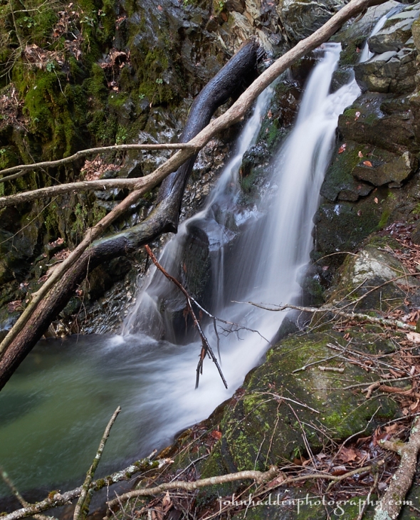
The falls on upper Fargo Brook yesterday afternoon.
Morning Observation:
This morning in Huntington at 7:35AM it’s currently 31 degrees under partly cloudy skies. Winds are calm. Relative humidity is 95%, dewpoint 29, barometric pressure 30.25” and rising. Yesterday’s high was 51, and the overnight low was 31.
Forecast:
While the first half of today is expected to be dry, a more active weather pattern will take hold this evening into Tuesday. A warm front will move across the region later this afternoon bringing light rain to our area overnight. A more significant storm system will roll in Monday night into Tuesday with a period of rain and
gusty south winds along with much above normal temperatures.
We’ll see cloudy skies today with highs in the lower 40s and light and variable winds. Tonight should be cloudy with a 20% chance of rain. Lows will be in the upper 30s with southeast winds 10 to 15 mph.
Monday should be mostly cloudy in the morning, then partly sunny with a chance of rain in the afternoon. Highs will be in the upper 40s with southeast winds 15 to 20 mph gusting up to 30 mph. Chance of rain is 40%. Low an upper level trough of low pressure will move into the region Monday night bringing widespread rain. Lows will be in the mid 40s with south winds 15 to 20 mph gusting up to 35 mph. Chance of rain is 90%.
Rain will continue into Tuesday. Highs will be in the upper 40s with west winds 10 to 15 mph. Chance of rain is 90%. Tuesday night should be partly cloudy with a 30% chance of rain showers. Lows will be in the lower 30s.
Almanac:
Last year on this date we had a high of 31 and a low of 25. We picked up 1″ of new snow and had 18″ at the stake.
Burlington averages for this date are highs of 34 and lows of 20.
The record high was 56°F in 1946.
The record low was -9°F in 1982.
Sky Notes:
Sunrise: 7:19 AM EST
Sunset: 4:13 PM EST
Length of Visible Light: 10h 00m
Length of Day: 8h 53m
Tomorrow will be 0m38s shorter.
The Moon is a waxing crescent, 2d 2h old with 5% illumination.
Moonrise: 8:48 AM EST
Moonset: 6:46 PM EST
About Today’s Photo:
Fargo Brook has a lovely little waterfall about 3/4 of a mile upstream from our house. The falls is about 15′ high and tumbles into a nice little poll at its foot. The walk up along the stream used to be pretty straightforward, but between the two floods of recent years and the snowstorm last December, the stream bed is now tangled with fallen trees making the walk more difficult. The brook itself is, in places, fairly choked with washed down gravel. I was glad that the falls itself was still intact, though the logs hanging over its lip did present a bit of a challenge compositionally!
Panasonic Lumix GM5, Lumix 14-140mm lens @ 14mm, circular polarizing filter, ISO 200, f/7.1, 1 second exposure.
Saturday, December 12, 2015
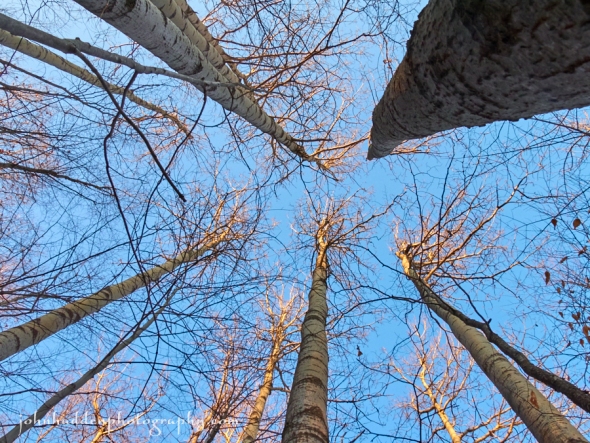
Aspen trees catch the last of the afternoon light above Delfrate Road
Morning Observation:
This morning in Huntington at 7:30AM it’s currently 39 degrees under mostly cloudy skies. Winds are out of the north at 0-3 mph. Relative humidity is 89%, dewpoint 36, barometric pressure 30.05” and rising rapidly. Yesterday’s high was 56, and the overnight low was 39.
Forecast:
Our not-winter continues. We’ll see cloudy skies this morning, becoming partly sunny this afternoon. Highs will be in the mid 40s with west winds 10 to 15 mph. Tonight should be partly cloudy until midnight, then become mostly cloudy. Lows will be in the upper 30s with light and variable winds.
Sunday should be mostly cloudy with highs in the upper 40s and light and variable winds. Sunday night should be cloudy with lows in the lower 40s and southeast winds around 10 mph.
A strong trough of low pressure will move northeast into the Great
Lakes region on Monday bringing showers and gusty winds. Highs will be in the lower 50s with southeast winds 15 to 20 mph gusting up to 30 mph. Chance of rain is 60%. Monday night showers are likely as the trough moves into our region. Lows will be in the lower 40s. Chance of rain is near 100%.
Almanac:
Last year on this date we had a high of 31 and a low of 25. We picked up 1″ of new snow and had 17.75″ at the stake. Our power was still out.
Burlington averages for this date are highs of 34 and lows of 20.
The record high was 59°F in 1899.
The record low was -13°F in 1977.
Sky Notes:
Sunrise: 7:18 AM EST
Sunset: 4:12 PM EST
Length of Visible Light: 10h 00m
Length of Day: 8h 54m
Tomorrow will be 0m41s shorter.
The Moon is a waxing crescent, 1d 2h old with 1% illumination.
Moonrise: 7:59 AM EST
Moonset: 5:47 PM EST
About Today’s Photo:
When in a prolonged stick season, go take pictures of sticks. These aspens on the hillside above Delfrate Road caught the last of the afternoon sunlight yesterday, glowing a warm yellow against the blue sky.
Panasonic Lumix GM5, Lumix 14-140mm lens @ 14mm, ISO 400, f/10, 1/160″ exposure.
Friday, December 11, 2015
A gall in a dried aster stem with a twist of morning glory vine
Morning Observation:
This morning in Huntington at 6:45AM it’s currently 50 degrees under overcast skies. Winds are out of the south at 4-8 mph. Relative humidity is 76%, dewpoint 43, barometric pressure 29.80”. Yesterday’s high was 54, and the overnight low was 37.
Forecast:
Unseasonably mild conditions will persist as a strong Pacific airstream (thank you El Niño) continues across California into the intermountain west and upper level troughs generally lift out across the Great Lakes and track north and west of our region. This pattern will maintain a general south to southwest airflow regime over the north country and will continue during the near-term and beyond. This will set up near record highs today and well above climatological averages for middle December through the next 5-7 day period.
We’ll see mostly cloudy this morning, becoming partly sunny later in the day. Highs will be in the mid 50s with south winds 10 to 15 mph. Tonight should be partly cloudy until midnight, then become mostly cloudy. Lows will be in the upper 30s with southwest winds 10 to 15 mph.
Saturday should be partly sunny with highs in the upper 40s and west winds around 10 mph in the morning, becoming light and variable. Saturday night should be mostly cloudy with lows in the upper 30s and light and variable winds.
Sunday’s looking mostly cloudy with highs in the upper 40s and light and variable winds. Sunday night should be mostly cloudy with lows in the lower 40s.
Almanac:
Last year on this date we had a high of 33 and a low of 28. We picked up 3.5″ of new snow and had 16″ at the stake. Our power was out.
Burlington averages for this date are highs of 35 and lows of 21.
The record high was 61°F in 1966.
The record low was -13°F in 1958.
Sky Notes:
Sunrise: 7:17 AM EST
Sunset: 4:12 PM EST
Length of Visible Light: 10h 01m
Length of Day: 8h 55m
Tomorrow will be 0m47s shorter.
The Moon is new, 1 hour old with 0% illumination.
Moonrise: 7:05 AM EST
Moonset: 4:53 PM EST
About Today’s Photo:
I’m not sure what happened to this shot as I was taking it, but when I viewed it on my computer, I was struck by the odd and interesting curve of blackness that seems to melt and bend the background of the photo beneath the subject—an aster stem and insect gall. Some quirk of optics and electronics methinks, but I really like the effect!
Panasonic Lumix GM5, Lumix 20mm prime, ISO 200, f/1.7, 1/2000″ exposure.
Thursday, December 10, 2015
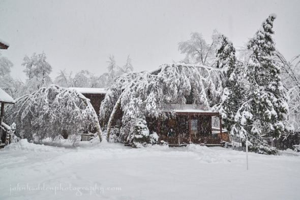
Our house the afternoon of December 10, 2014
Morning Observation:
This morning in Huntington at 7:10AM it’s currently 47 degrees and raining lightly under overcast skies. Winds are out of the SW at 0-3 mph. Relative humidity is 89%, dewpoint 44, barometric pressure 29.89”. We picked up 0.03” of rain overnight. Yesterday’s high was 47, and the overnight low was 46.
Forecast:
A trough of low pressure moving from west to east across the region will bring breezy conditions with a brief period of light rain showers this morning. Rainfall amounts will generally be under a tenth of an inch. Dry weather will prevail Thursday night and into the weekend with temperature continuing to be unseasonably warm.
We’ll see cloudy with a 50% chance of showers this morning, then partly sunny skies this afternoon. Highs will be in the upper 40s with south winds 10 to 15 mph. Tonight should be mostly cloudy with lows in the upper 30s and south winds around 10 mph.
Friday should be mostly cloudy in the morning, then become partly sunny. Highs will be in the lower 50s with south winds 10 to 15 mph. Friday night should be partly cloudy with lows in the upper 30s and southwest winds around 10 mph.
Saturday’s looking partly sunny with highs in the upper 40s and light and variable winds. Saturday night should be mostly cloudy with lows in the upper 30s.
Almanac:
Last year on this date we had a high of 33 and a low of 29. It was the start of the heavy, damaging snow storm that I’m sure we all remember. We picked up 0.34″ of rain and 15.75″ of the densest and heaviest snow that I’ve ever seen. We lost power at 2:15AM as trees snapped and brought down power lines. Our power didn’t come back on until the evening of 12/14. The skiing was great!
Burlington averages for this date are highs of 35 and lows of 21.
The record high was 61°F in 1966.
The record low was -9°F in 1958.
Sky Notes:
Sunrise: 7:16 AM EST
Sunset: 4:12 PM EST
Length of Visible Light: 10h 02m
Length of Day: 8h 56m
Tomorrow will be 0m50s shorter.
The Moon is a waning crescent, 28d 18h old with 1% illumination. Moonrise: 6:08 AM EST
Moonset: 4:06 PM EST
About Today’s Photo:
This was the scene a year ago today. Heavy, dense snow blanketed the region bringing down trees with snap-cracking regularity during the day and night. Definitely not what we’re seeing today as well above average temperatures are expected right through next week.
Nikon D600, Nikon 24-120mm lens @ 24mm, ISO 1250, f/14, 1/100″ exposure.
Wednesday, December 9, 2015
The color of the season in our front field
Morning Observation:
This morning in Huntington at 6:50AM it’s currently 28 degrees under party cloud skies. Winds are calm. Relative humidity is 97%, dewpoint 27, barometric pressure 30.10”. Yesterday’s high was 40, and the overnight low was 27.
Forecast:
Surface high pressure will remain in control today as it shifts slowly eastward into the Gulf of Maine by this afternoon. Southerly winds will develop this afternoon allowing temperatures to moderate into the middle to upper 40s for the Champlain and St. Lawrence Valley areas. A weak upper level disturbance will shift eastward from the Great Lakes tonight bringing breezy conditions overnight with valley rain showers early Thursday morning, mixing with light snow or sleet across the mountains and across far northeastern Vermont.
We’ll see partly sunny skies today with highs in the mid 40s and south winds around 10 mph. Tonight should be cloudy with a 40% chance of rain after midnight. Lows will be in the mid 30s with south winds 10 to 15 mph gusting up to 25 mph.
Thursday should be cloudy with a 40% chance of rain in the morning, then a slight chance of rain showers in the afternoon. Highs will be in the upper 40s with south winds around 10 mph. Thursday night should be mostly cloudy with lows in the upper 30s and south winds around 10 mph.
Friday’s looking mostly cloudy and unseasonably mild with highs around 50 and south winds around 10 mph. Friday night should be partly cloudy with lows in the upper 30s.
Almanac:
Last year on this date we had a high of 38 and a low of 29. We had 1.80″ of snow on the ground.
Burlington averages for this date are highs of 36 and lows of 22.
The record high was 61°F in 1966.
The record low was -10°F in 1902.
Sky Notes:
Sunrise: 7:15 AM EST
Sunset: 4:12 PM EST
Length of Visible Light: 10h 03m
Length of Day: 8h 57m
Tomorrow will be 0m55s shorter.
The Moon is a waning crescent, 27d 18h old with 4% illumination.
Moonrise: 5:09 AM EST
Moonset: 3:25 PM EST
About Today’s Photo:
Dried asters beneath a clear sky in our front field. Stick season drags on. A little snow would be nice…
Panasonic Lumix GM5, Lumix 20mm lens, ISO 200, f/1.7, 1/5000″ exposure.
Tuesday, December 8, 2015

Red oak leaves in bright morning sun
Morning Observation:
This morning in Huntington at 6:30AM it’s currently 23 degrees under mostly cloudy skies. Winds are calm. Relative humidity is 96%, dewpoint 23, barometric pressure 30.17”. Yesterday’s high was 42, and the overnight low was 22.
Forecast:
High pressure will bring light winds and seasonable temperatures
to the region today. A gradual warming trend will begin Wednesday and continues right through Friday as the airflow aloft becomes more southwesterly. A weak upper level disturbances will move across the region late Wednesday night into Thursday bringing rain showers to the Champlain Valley with some light mix of sleet and snow possible in the Adirondacks and along and east of the Green Mountains for a time Thursday morning.
We’ll see patchy fog this morning. It’ll be partly sunny with highs in the upper 30s and light and variable winds. Tonight should be partly cloudy with lows in the mid 20s and light and variable winds.
Wednesday should be partly sunny with highs in the lower 40s and south winds around 10 mph. Wednesday night should be mostly cloudy with a 40% chance of rain showers as the aforementioned disturbance moves through. Lows will be in the lower 30s with south winds around 10 mph.
Thursday’s looking mostly cloudy with highs in the mid 40s and south winds around 10 mph. Thursday night should be partly cloudy with lows in the upper 30s.
Almanac:
Last year on this date we had a high of 29 and a low of 2 (brrrr!) We had 1.80″ of snow on the ground.
Burlington averages for this date are highs of 36 and lows of 22.
The record high was 58°F in 1927.
The record low was -10°F in 1906.
Sky Notes:
Sunrise: 7:14 AM EST
Sunset: 4:12 PM EST
Length of Visible Light: 10h 04m
Length of Day: 8h 58m
Tomorrow will be 0m59s shorter.
The Moon is a waning crescent, 26d 18h old with 8% illumination.
Moonrise: 4:10 AM EST
Moonset: 2:49 PM EST
About Today’s Photo:
The red oak in our front yard keeps its dried leaves for quite a while…
Panasonic Lumix GM5, Lumix 20mm lens, ISO 200, f/1.7, 1/6500″ exposure.
Monday, December 7, 2015
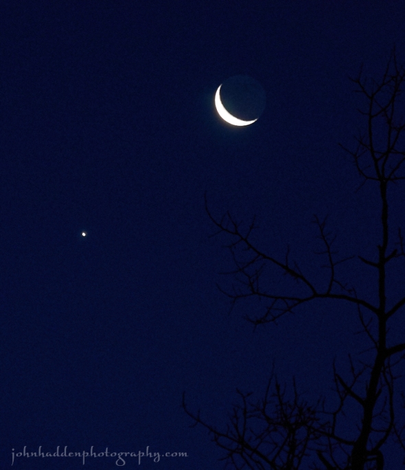
Venus and the crescent moon in this morning’s sky
Morning Observation:
This morning in Huntington at 6:45AM it’s currently 24 degrees under clear skies. Winds are calm. The beautiful pairing the crescent moon and Venus hang in the southeast sky. Relative humidity is 96%, dewpoint 23, barometric pressure 30.16”. Yesterday’s high was 42, and the overnight low was 23.
Forecast:
High pressure over the region this morning will continue to deliver dry, and seasonably mild conditions for the next two days. We’ll see partly sunny skies today with highs in the mid 30s and light and variable winds, becoming northwesterly around 10 mph this afternoon. Tonight should be mostly cloudy until midnight, then becoming partly cloudy with patchy valley fog after midnight. Lows will be in the lower 20s with light and variable winds.
Tuesday should be partly sunny with highs in the upper 30s and light and variable winds. Tuesday night should be partly cloudy with lows in the mid 20s and light and variable winds.
Wednesday’s looking partly sunny with highs in the lower 40s and south winds around 10 mph. A shortwave trough will cross the region Wednesday night brining mostly cloudy skies with a 30% chance of rain or sleet over higher elevations. Lows will be in the lower 30s.
Almanac:
Last year on this date we had a high of 30 and a low of 2(!). We had 1.80″ of snow on the ground.
Burlington averages for this date are highs of 36 and lows of 23.
The record high was 67°F in 1998 (we had a high of 64).
The record low was -6°F in 1906.
Sky Notes:
Sunrise: 7:13 AM EST
Sunset: 4:12 PM EST
Length of Visible Light: 10h 05m
Length of Day: 8h 59m
Tomorrow will be 1m4s shorter.
The Moon is a waning crescent, 25d 18h old with 14% illumination.
Moonrise: 3:12 AM EST
Moonset: 2:17 PM EST
About Today’s Photo:
Venus and the crescent moon put on a lovely show in this morning’s sky. Jupiter was just a bit to the west as well.
Panasonic Lumix GM5, Lumix 14-140mm lens @ 102mm, ISO 1600, f/5.4, 1/20″ exposure.
