Monday, November 30, 2015
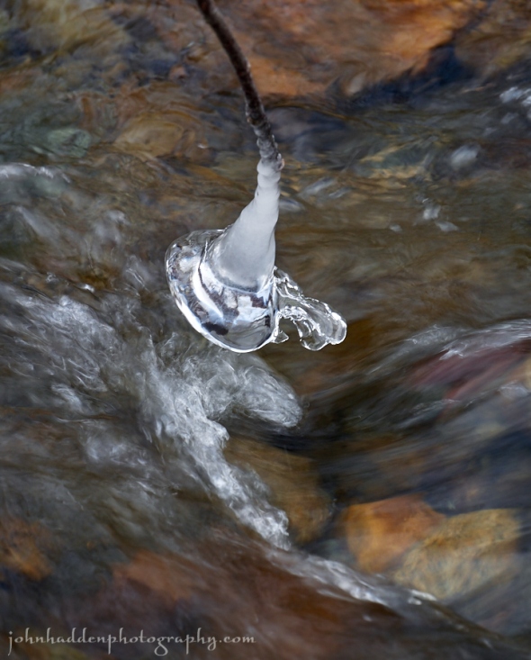
Built up ice dangles from a twig over Fargo Brook
Morning Observation:
This morning in Huntington at 6:50AM it’s currently a brisk 14 degrees under clear skies. Winds are calm. Relative humidity is 93%, dewpoint 13, barometric pressure 30.51” and rising. We picked up a 0.50” dusting of snow in the past 24hrs. Yesterday’s high was 32, and the overnight low was 14.
Forecast:
A building area of high pressure will produce mostly sunny skies
today with slightly below normal temperatures. The next weather
system arrives late Tuesday into Wednesday. A brief wintry mix is
possible with the initial surge of moisture, but expect mostly
rain with this event as temperatures warm back above normal.
We’ll see sunny skies today with highs in the lower 30s and light and variable winds, becoming southerly around 10 mph this afternoon. Tonight should be clear with lows in the lower 20s and light and variable winds.
Tuesday should start off partly sunny in the morning, then become cloudy with a 50% chance of rain in the afternoon as a warm front and associated moisture move in from the southwest. Highs will be around 40 with light and variable winds, becoming southerly around 10 mph in the afternoon. Tuesday night rain is likely with near steady temperature in the upper 30s and south winds 10 to 15 mph. Chance of rain is near 100%.
Wednesday’s looking cloudy with a 50% chance of rain showers. Highs will be in the lower 40s with southwest winds around 10 mph. Wednesday night should be mostly cloudy with a 50% chance of rain or snow showers as a cold/occluded front moves in from the Great Lakes. Lows will be around 30.
Almanac:
Last year on this date we had a high of 47 and a low of 32. We had 4″ of snow on the ground.
Burlington averages for this date are highs of 39 and lows of 26.
The record high was 63°F in 2006 (we had a high of 64).
The record low was -2°F in 1958.
Sky Notes:
Sunrise: 7:06 AM EST
Sunset: 4:14 PM EST
Length of Visible Light: 10h 13m
Length of Day: 9h 08m
Tomorrow will be 1m32s shorter.
The Moon is waning gibbous, 18d 18h old with 77% illumination.
Moonrise: 9:20 PM EST
Moonset: 10:51 AM EST
About Today’s Photo:
This pendulous pod of ice had built up on a twig just above the moving surface of Fargo Brook.
Panasonic Lumix GM5, Lumix 14-140mm lens @ 88mm, ISO 200, f/9, 1/30″ exposure.
Sunday, November 29, 2015
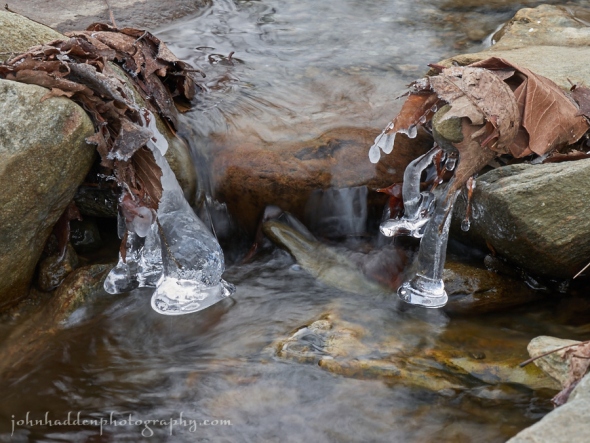
Ice begins to form on Fargo Brook
Morning Observation:
This morning in Huntington at 8:20AM it’s currently 19 degrees under mostly clear skies. Winds are calm. Relative humidity is 95%, dewpoint 18, barometric pressure 30.31” and rising. Yesterday’s high was 39, and the overnight low was 19.
Forecast:
High pressure will continue building in across the region today with calm and quiet weather expected through the rest of the weekend and into start the work week. We’ll see partly sunny skies today with highs in the lower 30s and northwest winds around 10 mph. Tonight should be partly cloudy until midnight, then clearing. Lows will be around 16 with north winds around 10 mph until midnight, becoming light and variable.
Monday should be sunny with highs in the mid 30s and light and variable winds, becoming southerly around 10 mph in the afternoon. Monday night should be clear with lows in the lower 20s and light and variable winds.
Tuesday should start off partly sunny with a 40% chance of rain showers later in the day as a warm front lifts northeastward out of the mid-Atlantic states. Highs will be around 40 with south winds around 10 mph. Tuesday night showers are likely. Lows will be in the mid 30s. Chance of rain is 90%.
Almanac:
Last year on this date we had a high of 32 and a low of 6. We picked up 1″ of new snow and had 6″ on the ground. (We had picked up 10.50″ on 11/26/14, 2.75″ on 11/27/14, and 1.5″ on 11/28/14.)
Burlington averages for this date are highs of 40 and lows of 26.
The record high was 68°F in 2005 (we had a high of 62).
The record low was 2°F in 1940.
Sky Notes:
Sunrise: 7:05 AM EST
Sunset: 4:15 PM EST
Length of Visible Light: 10h 14m
Length of Day: 9h 10m
Tomorrow will be 1m34s shorter.
The Moon is waning gibbous, 17d 19h old with 84% illumination. Moonrise: 8:19 PM EST
Moonset: 10:10 AM EST
About Today’s Photo:
Cold temperatures are allowing ice to set up on Fargo Brook.
Panasonic Lumix GM5, Lumix 14-140mm lens @ 84mm, ISO 200, f/14, 1/10″ exposure.
Tuesday, November 24, 2015
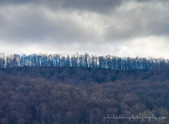
Bare trees along a ridgeline down in Hanksville
Morning Observation:
This morning in Huntington at 7:45AM it’s currently 20 degrees under party cloudy skies. Winds are calm. A few random snowflakes are drifting down. Relative humidity is 93%, dewpoint 18, barometric pressure 30.27” and rising. Yesterday’s high was 31, and the overnight low was 26.
Forecast:
A weakening upper level disturbance will bring clouds and a few snow showers or flurries to the area into this evening, mainly across northern New York. High pressure will then build into the region for Wednesday into Thursday along with fair weather and moderating temperatures.
We’ll see mostly cloudy skies with a 20% chance of snow showers. Highs will again be on the chilly side—in the lower 30s—with southwest winds around 10 mph, becoming northwesterly this afternoon. Tonight should be mostly cloudy with a slight chance of snow showers until midnight, then partly cloudy after midnight. Lows will be in the lower 20s with light and variable winds. Chance of snow is 20%.
Wednesday should be mostly sunny as high pressure builds in. Highs will be in the upper 30s with light and variable winds, becoming southerly around 10 mph in the afternoon. Wednesday night should be mostly clear with lows around 30 and south winds 10 to 15 mph.
Thanksgiving Day is looking partly sunny with highs in the upper 40s and south winds 10 to 15 mph gusting up to 25 mph. Thursday night should be partly cloudy with lows in the mid 40s.
Almanac:
Last year on this date we had a high of 67 and a low of 38. We picked up 0.19″ of rain.
Burlington averages for this date are highs of 42 and lows of 28.
The record high was 67°F in 2014 (we had a high of 67).
The record low was 2°F in 1956.
Sky Notes:
Sunrise: 6:59 AM EST
Sunset: 4:17 PM EST
Length of Visible Light: 10h 22m
Length of Day: 9h 18m
Tomorrow will be 1m52s shorter.
The Moon is waxing gibbous, 12d 19h old with 97% illumination.
Moonrise: 3:49 PM EST
Moonset: 5:03 AM EST
About Today’s Photo:
I’ve been kind of captivated by the look of light coming through bare trees along ridgelines this time of year. This ridge above Hanksville drew my eye.
Monday, November 23, 2015
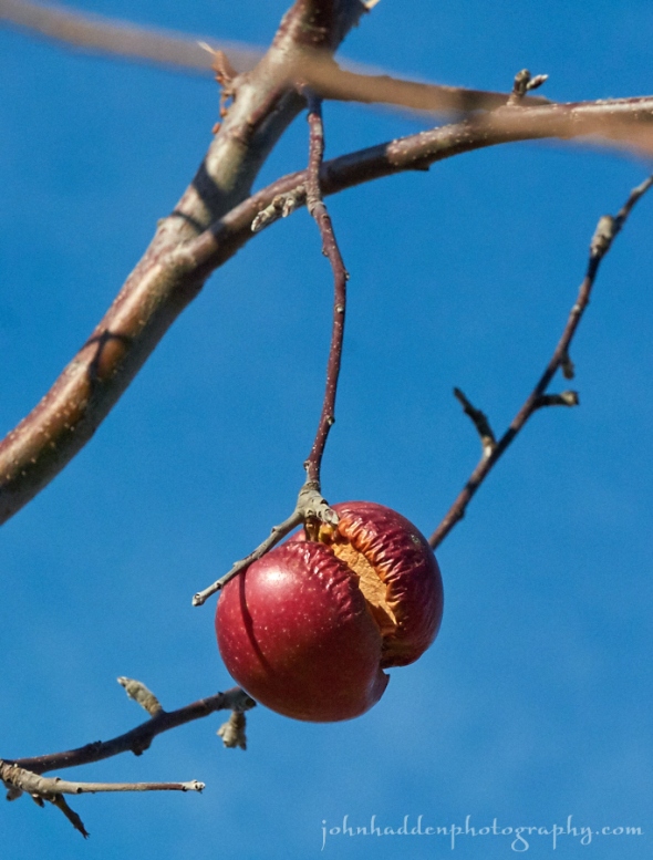
An apple cleaved by frost
Morning Observation:
This morning in Huntington at 6:50AM it’s currently 26 degrees under overcast skies. Winds are out of the northwest at 4-8 mph. Relative humidity is 83%, dewpoint 21, barometric pressure 30.02” and rising slowly. Yesterday’s high was 48, and the overnight low was 26.
Forecast:
Mostly sunny and brisk conditions today will give way to increasing clouds and a few light snow showers later tonight and into Tuesday as a weakening area of low pressure moves through the region. A ridge of high pressure will then build across the north country Wednesday through Friday with dry weather and moderating temperatures.
We’ll see mostly sunny skies today with highs only in the lower 30s and northwest winds 10 to 15 mph. Tonight should be mostly clear until midnight, then become partly cloudy. Lows will be around 18 with northwest winds around 10 mph, becoming westerly after midnight.
Tuesday should be partly sunny with a 30% chance of snow showers. Highs will be in the lower 30s with light and variable winds. Tuesday night should be mostly clear with lows in the lower 20s and light and variable winds.
Wednesday’s looking sunny with highs in the upper 30s and south winds around 10 mph. Wednesday night should be mostly clear with lows in the lower 30s.
Almanac:
Last year on this date we had a high of 51 and a low of 36. We picked up 0.11″ of rain.
Burlington averages for this date are highs of 42 and lows of 29.
The record high was 68°F in 1953.
The record low was 2°F in 1972.
Sky Notes:
Sunrise: 6:57 AM EST
Sunset: 4:18 PM EST
Length of Visible Light: 10h 24m
Length of Day: 9h 20m
Tomorrow will be 1m54s shorter.
The Moon is waxing gibbous, 11d 18h old with 92% illumination. Moonrise: 3:09 PM EST
Moonset: 3:50 AM EST
About Today’s Photo:
We went over to Boyer’s Orchard in Monkton yesterday morning to pick up some late season apples for making cider. I noticed quite a few apples still clinging to the trees that had been cleaved by frost and freezing. This one had started drying out as well.
Panasonic Lumix GM5, Lumix 14-140mm lens @ 140mm, ISO 3200, f/13, 1/3200″ exposure (guess I shoulda checked my ISO…)
Sunday, November 22, 2015

Multi-colored slime fungus on a fallen tree along Fargo Brook
Morning Observation:
This morning in Huntington at 7:55AM it’s currently a blustery 46 degrees under mostly cloudy skies. Winds are out of the south at 5-8 mph. Relative humidity is 79%, dewpoint 40, barometric pressure 29.84” and rising. We picked up a 0.01” trace of rain in the past 25hrs. Yesterday’s high was 43, and the overnight low was 38.
Forecast:
Low pressure centered just east of James Bay and its associated cold front will move northeast and away from the region today leaving breezy conditions in its wake. Any scattered rain and higher elevation snow showers will come to an end this morning. A ridge of high pressure will then build into the region with fair and dry weather expected through the upcoming week.
We’ll see partly sunny skies today with a 30% chance of rain showers this morning. Highs will be in the mid 40s with southwest winds around 15 mph and gusting up to 25 mph, becoming westerly this afternoon. Tonight should be mostly clear with lows around 19 and northwest winds around 10 mph.
Monday should be mostly sunny and seasonably cool with highs in the lower 30s and northwest winds around 10 mph. Monday night should be partly cloudy with lows around 19 and northwest winds around 10 mph.
Tuesday should be partly sunny with highs in the mid 30s and light and variable winds. Tuesday night should be partly cloudy with lows in the upper 20s.
Almanac:
Last year on this date we had a high of 40 and a low of 13.
Burlington averages for this date are highs of 43 and lows of 29.
The record high was 69°F in 1953.
The record low was 3°F in 1969.
Sky Notes:
Sunrise: 6:56 AM EST
Sunset: 4:19 PM EST
Length of Visible Light: 10h 26m
Length of Day: 9h 22m
Tomorrow will be 1m59s shorter.
The Moon is waxing gibbous, 10d 19h old with 85% illumination.
Moonrise: 2:32 PM EST
Moonset: 2:37 AM EST
About Today’s Photo:
My eye was drawn to this collection of multi-colored slime fungus on a fallen tree along Fargo Brook. The individual heads are now bigger than the head of a pin, but the color pops from its muted surroundings.
Panasonic Lumix GM5, Lumix 30mm macro lens, ISO 400, f/5.6, 1/80″ exposure.
Saturday, November 21, 2015
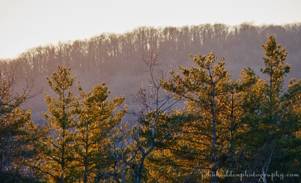
Layers of trees catch late afternoon sunshine
Morning Observation:
This morning in Huntington at 6:50AM it’s currently a frosty 24 degrees under mostly cloudy skies. Wind are calm. Relative humidity is 96%, dewpoint 23, barometric pressure 30.32”. Yesterday’s high was 51, and the overnight low was 23.
Forecast:
An approaching low pressure center will track northeastward from Lake Erie this evening into north central Ontario by noon Sunday. This will drag a cold front across the region later tonight and into Sunday morning bringing increasing clouds for today along with breezy conditions and with some light rain and mountain snow showers tonight and into Sunday.
We’ll see partly sunny skies this morning with highs in the mid 40s and light and variable winds. Tonight should be mostly cloudy with a slight chance of rain or mountain snow showers after midnight. Lows will be in the mid 30s with southeast winds 15 to 20 mph. Chance of precipitation is 20%.
Sunday should be mostly cloudy with a chance of rain showers in the morning, then partly sunny with isolated rain showers in the afternoon as high pressure builds in behind the departing cold front. Highs will be in the mid 40s with south winds 10 to 15 mph gusting up to 30 mph and becoming westerly in the afternoon. Chance of rain is 50%. Sunday night should be partly cloudy with lows in the mid 20s and west winds around 10 mph.
Monday’s looking mostly sunny and seasonably cool with highs in the mid 30s and northwest winds around 10 mph. Monday night should be partly cloudy with lows in the mid 20s.
Almanac:
Last year on this date we had a high of 26 and a low of 15.
Burlington averages for this date are highs of 43 and lows of 30.
The record high was 66°F in 1931.
The record low was 1°F in 1933.
Sky Notes:
Sunrise: 6:55 AM EST
Sunset: 4:19 PM EST
Length of Visible Light: 10h 28m
Length of Day: 9h 24m
Tomorrow will be 2m1s shorter.
The Moon is waxing gibbous, 9d 18h old with 75% illumination.
Moonrise: 1:57 PM EST
Moonset: 1:24 AM EST
About Today’s Photo:
White pines and the distant ridge of bare hardwoods glow in late afternoon sunlight.
Panasonic Lumix GM5, Lumix 100-300mm lens @ 300mm, ISO 400, f/8, 1/80″ exposure.
Friday, November 20, 2015
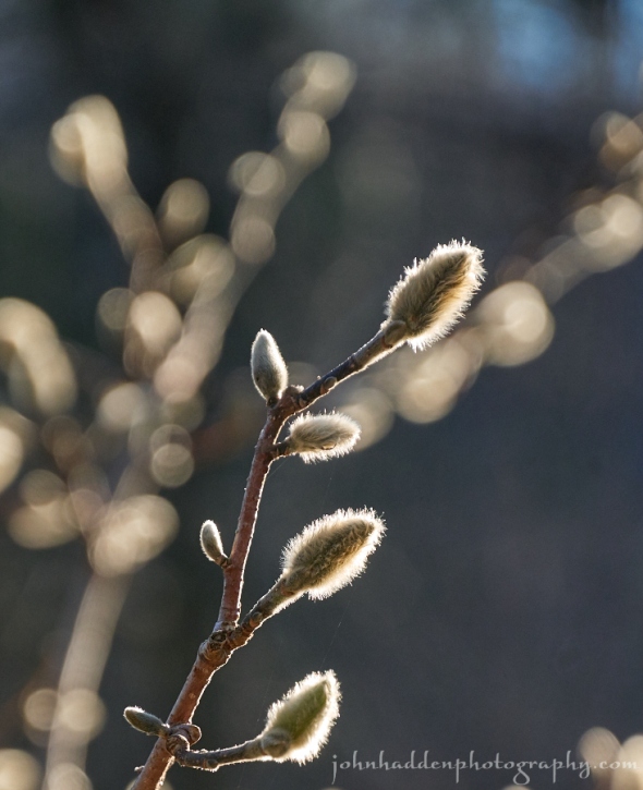
Magnolia buds catch morning sunlight
Morning Observation:
This morning in Huntington at 6:50AM it’s currently 42 degrees under overcast skies. Wind are calm. Relative humidity is 95%, dewpoint 41, barometric pressure 30.04” and rising slowly. We picked up 0.63” of rain in the past 24hrs. Yesterday’s high was 55, and the overnight low was 42.
Forecast:
High pressure will gradually build into the region today which will end any lingering rain showers this morning and bring some sunshine this afternoon. Dry weather and seasonal temperatures are expected on Saturday.
We’ll see partly sunny skies today with highs in the upper 40s and southwest winds around 10 mph. Tonight should be mostly clear with lows in the upper 20s and light and variable winds.
Saturday should be partly sunny in the morning, then become mostly cloudy as low pressure approaches from the Great Lakes. Highs will be in the lower 40s with light and variable winds. Saturday night should be mostly cloudy with a 50% chance of rain or snow showers. Lows will be in the lower 30s with southeast winds 10 to 15 mph.
Sunday’s looking partly sunny with a 50% chance of rain showers. Highs will be in the lower 40s with southwest winds 10 to 15 mph gusting up to 25 mph. Sunday night should be partly cloudy with lows in the lower 20s.
Almanac:
Last year on this date we had a high of 35 and a low of 22.
Burlington averages for this date are highs of 44 and lows of 30.
The record high was 71°F in 1991.
The record low was 5°F in 1933.
Sky Notes:
Sunrise: 6:53 AM EST
Sunset: 4:20 PM EST
Length of Visible Light: 10h 30m
Length of Day: 9h 26m
Tomorrow will be 2m4s shorter.
The Moon is waxing gibbous, 8d 18h old with 64% illumination.
Moonrise: 1:23 PM EST
Moonset: 12:14 AM EST
About Today’s Photo:
The magnolia by out back deck has set a prodigious crop of buds. It’ll be a long wait before they bloom…
Panasonic Lumix GM5, Lumix 14-140mm lens @ 109mm, ISO 400, f/5.4, 1/500″ exposure.
Thursday, November 19, 2015

The crescent moon in a late afternoon sky
Morning Observation:
This morning in Huntington at 7:30AM it’s currently a balmy 54 degrees under overcast skies. Winds are out of the south at 4-6 mph. Relative humidity is 77%, dewpoint 47, barometric pressure 30.18” and falling slowly. Yesterday’s high was 53, and the overnight low was 49.
Forecast:
Deep low pressure currently centered over northern Ontario will slowly drag an warm/occluded front through the region over the next 36 hours bringing showers, breezy conditions, and above normal temperatures.
We’ll see cloudy skies today with showers likely mainly this afternoon. Highs will be in the mid 50s with southeast winds 15 to 25 mph and gusting up to 45 mph. Chance of rain is 90%. Showers will continue into tonight with lows in the lower 40s and southeast winds 15 to 25 mph gusting up to 45 mph, then becoming westerly around 10 mph after midnight. Chance of rain is near 100%.
Friday should be partly sunny with a 30% chance of rain showers in the morning, then sunny in the afternoon. Highs will be in the upper 40s with northwest winds around 10 mph. Friday night should be mostly clear and cooler with lows in the upper 20s and northwest winds around 10 mph.
Saturday’s looking partly sunny with highs in the lower 40s and light and variable winds. Saturday night should be mostly cloudy with a 40% chance of rain or snow showers as a shortwave trough slides our way. Lows will be in the lower 30s.
Almanac:
Last year on this date we had a high of 30 and a low of 22.
Burlington averages for this date are highs of 44 and lows of 30.
The record high was 70°F in 1921.
The record low was 7°F in 1924.
Sky Notes:
Sunrise: 6:52 AM EST
Sunset: 4:21 PM EST
Length of Visible Light: 10h 32m
Length of Day: 9h 28m
Tomorrow will be 2m6s shorter.
The Moon is in its first quarter, 7d 18h old with 53% illumination.
Moonrise: 12:49 PM EST
No Moon Set
About Today’s Photo:
I like the way the crescent moon hangs in the late afternoon sky as if it’s keeping tabs on the transition from day to nighttime. This shot is from a couple of days ago. This evening it will be in its first quarter—appearing to be half-full.
Panasonic Lumix GM5, Lumix 100-300mm lens @ 234mm, ISO 400, f/8, 1/250″ exposure.
Wednesday, November 18, 2015

One of the Taft’s Jersey heifers peeks out from behind some trees
Morning Observation:
This morning in Huntington at 7:10AM it’s currently a frosty 24 degrees under clear skies. Winds are calm. Relative humidity is 94%, dewpoint 22, barometric pressure 30.50”. Yesterday’s high was 43, and the overnight low was 22.
Forecast:
A ridge of high pressure will remain over New England through today bringing dry weather with temperatures moderating into the upper 40s to lower 50s this afternoon. A frontal system approaching from the Great Lakes and Ohio River valley will bring increasingly windy and mild conditions for Wednesday night into Thursday. The front will bring a period of light to moderate rain to northern New York and Vermont mainly Thursday afternoon into Thursday night.
We’ll see sunny skies today with highs around 50 and south winds 10 to 15 mph. Tonight should be partly cloudy until midnight, then become mostly cloudy with a 20% chance of showers after midnight. Lows will be around 40 with south winds 15 to 20 mph and gusting up to 35 mph after midnight.
Thursday should be cloudy with showers mainly in the afternoon. It’ll be breezy with highs in the mid 50s and southeast winds 15 to 25 mph gusting up to 45 mph. Chance of rain is 90%. Showers will continue into Thursday night with lows around 40 and south winds 20 to 25 mph gusting up to 45 mph. Chance of rain is near 100%.
Friday’s looking partly sunny with a 40% chance of showers. Highs will be in the mid 40s with northwest winds around 10 mph. Friday night should be partly cloudy with lows in the upper 20s.
Almanac:
Last year on this date we had a high of 37 and a low of 22. We picked up 0.29″ of rain and 0.25″ of snow. We were down to bare ground at the snow stake.
Burlington averages for this date are highs of 45 and lows of 31.
The record high was 70°F in 1892.
The record low was 9°F in 1924.
Sky Notes:
Sunrise: 6:51 AM EST
Sunset: 4:22 PM EST
Length of Visible Light: 10h 34m
Length of Day: 9h 31m
Tomorrow will be 2m9s shorter.
The Moon is a waxing crescent, 6d 18h old with 42% illumination.
Moonrise: 12:13 PM EST
Moonset: 11:04 PM EST
About Today’s Photo:
The Tafts have their Jersey heifers pastured up on their upper field where they can get into the trees along Taft Road. A group of them were having out amongst the trees the other morning.
Panasonic Lumix GM5, Lumix 14-140mm lens @ 84mm, ISO 400, f/5.4, 1/100″ exposure.
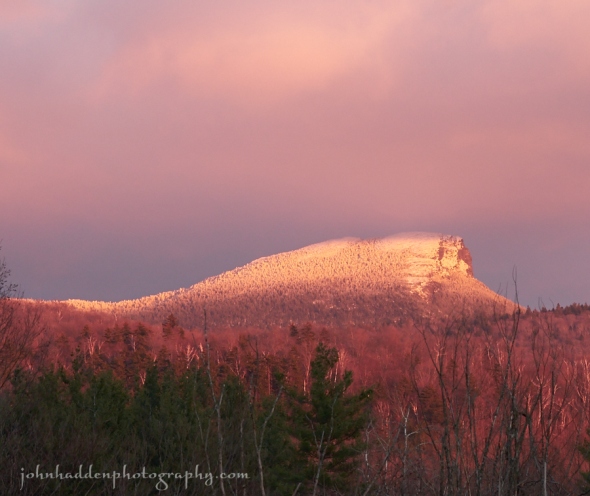
Tuesday, November 17, 2015
Morning Observation:
This morning in Huntington at 6:50AM it’s currently a brisk and frosty 19 degrees under clear skies. Winds are calm. Relative humidity is 94%, dewpoint 17, barometric pressure 30.56” and rising. Yesterday’s high was 47, and the overnight low was 19.
Forecast:
High pressure will provide pleasant late Fall conditions
to the region today and Wednesday with mostly clear skies. A frontal system approaching from the Great Lakes and Ohio River valley will bring increasingly windy and mild conditions for Wednesday night into Thursday.
After a chilly start, we’ll see sunny skies today with highs in the lower 40s and light and variable winds. Tonight should be clear with lows in the lower 20s and light and variable winds.
Wednesday should be mostly sunny with highs in the upper 40s and south winds around 10 mph. Wednesday night should be partly cloudy with lows in the upper 30s and southeast winds 15 to 20 mph gusting up to 30 mph.
Thursday showers are likely as the aforementioned warm front moves in. Highs will be in the mid 50s with southeast winds 15 to 20 mph gusting up to 35 mph. Chance of rain is 70%. Thursday night showers are likely. Lows will be in the lower 40s. Chance of rain is 80%.
Almanac:
Last year on this date we had a high of 38 and a low of 32. We picked up 0.32″ of rain, 1″ of snow and had 1.5″ of snow on the ground.
Burlington averages for this date are highs of 45 and lows of 31.
The record high was 70°F in 2006 (we had a high of 68).
The record low was 7°F in 1924.
Sky Notes:
Sunrise: 6:50 AM EST
Sunset: 4:23 PM EST
Length of Visible Light: 10h 36m
Length of Day: 9h 33m
Tomorrow will be 2m12s shorter.
The Moon is a waxing crescent, 5d 18h old with 31% illumination.
Moonrise: 11:33 AM EST
Moonset: 9:58 PM EST
About Today’s Photo:
The late afternoon light yesterday was quite lovely. Camel’s Hump lit up with alpenglow as the sun set.
Panasonic Lumix GM5, Lumix 100-300mm lens @ 171mm, ISO 400, f/11, 1/30″ exposure.
Monday, November 16, 2015

A thick stand of horsetails along Fargo Brook
Morning Observation:
This morning in Huntington at 6:55AM it’s currently 37 degrees under partly cloudy skies. Winds are calm. Relative humidity is 98%, dewpoint 36, barometric pressure 30.19” and rising slowly. Yesterday’s high was 49, and the overnight low was 34.
Forecast:
High pressure currently building into the region will provide seasonally tranquil
conditions through Tuesday night, before a cold front approaching from the west brings warm and windy conditions Wednesday, followed by rain for Thursday.
We’ll see partly sunny skies today with highs around 40 and northwest winds around 10 mph. Tonight should be clear with lows in the lower 20s and light and variable winds.
Tuesday should be sunny with highs in the mid 40s and light and variable winds. Tuesday night should be clear with lows in the lower 20s and light and variable winds.
Wednesday’s looking mostly sunny and mild with highs in the upper 40s and south winds 10 to 15 mph gusting up to 25 mph. Wednesday night should be mostly cloudy and breezy with lows in the lower 40s.
Almanac:
Last year on this date we had a high of 36 and a low of 28. We had 1″ of snow on the ground.
Burlington averages for this date are highs of 45 and lows of 31.
The record high was 73°F in 1989.
The record low was 6°F in 1933.
Sky Notes:
Sunrise: 6:48 AM EST
Sunset: 4:24 PM EST
Length of Visible Light: 10h 38m
Length of Day: 9h 35m
Tomorrow will be 2m15s shorter.
The Moon is a waxing crescent, 4d 18h old with 22% illumination.
Moonrise: 10:50 AM EST
Moonset: 8:54 PM EST
About Today’s Photo:
I find horsetails fascinating. These ancient plants have remained basically unchanged since the time of the dinosaurs. As a kid I used to methodically pull their segments apart (okay, so I still do it, it’s very satisfying…) The silicas in the stems makes for a fine pot scrubber as well when you’re out in the bush and forgot your Brillo pad!
Panasonic Lumix GM5, Lumix 14-140mm lens @ 140mm, ISO 400, f/7.1, 1/30s exposure.
Sunday, November 15, 2015

Sliding water in Fargo Brook
Morning Observation:
This morning in Huntington at 8:05AM it’s currently 30 degrees under mostly clear skies. Winds are calm. Relative humidity is 96%, dewpoint 29, barometric pressure 30.14” and falling slowly. Yesterday’s high was 38, and the overnight low was 28. Despite the off-and-on snow yesterday, we only managed to accumulate a dusting on cold surfaces like our deck.
Forecast:
Surface high pressure building into the region today will dominate our weather through mid-week, resulting in dry weather and temperatures near to above normal We’ll see partly sunny skies this morning, then mostly cloudy skies later. Highs will be in the upper 40s with southwest winds 10 to 15 mph. Tonight should be partly cloudy with lows in the lower 30s and northwest winds around 10 mph.
Monday should be partly sunny with highs in the lower 40s and north winds around 10 mph. Monday night should be clear with lows in the lower 20s and light and variable winds.
Tuesday’s looking sunny with highs in the lower 40s and light and variable winds. Tuesday night should be clear with lows in the upper 20s.
Almanac:
Last year on this date we had a high of 34 and a low of 21. We picked up 0.25″ of snow and had 1″ on the ground. Our pond had frozen over.
Burlington averages for this date are highs of 46 and lows of 31.
The record high was 67°F in 1956.
The record low was 9°F in 1933.
Sky Notes:
Sunrise: 6:47 AM EST
Sunset: 4:25 PM EST
Length of Visible Light: 10h 40m
Length of Day: 9h 37m
Tomorrow will be 2m16s shorter.
The Moon is a waxing crescent, 3d 19h old with 14% illumination.
Moonrise: 10:03 AM EST
Moonset: 7:54 PM EST
About Today’s Photo:
Water brightens and slides over moss covered limestone in Fargo Brook.
Panasonic Lumix GM5, Lumix 14-140mm lens @ 26mm, ISO 400, f/13, 1/4″ exposure.
Saturday, November 14, 2015

Dried grasses in the front field define the color of the day
Morning Observation:
This morning in Huntington at 8:10AM it’s currently 30 degrees and snowing lightly under overcasts skies. Wind are out of the west at 2-4 mph. Relative humidity is 88%, dewpoint 27, barometric pressure 29.90” and rising rapidly. We picked up 0.68” of rain in the past 24hrs and a dusting of snow/graupel/frozen sleet overnight. Yesterday’s high was 49, and the overnight low was 30.
Forecast:
Low pressure is currently exiting the region to the east and high pressure will begin to build in from the west. Any mountain driven rain and snow showers will slowly dissipate this morning, with cloudy but drier conditions prevailing this afternoon. High pressure will continue to strengthen over the region Sunday through mid-week, bringing dry weather and seasonal temperatures.
We’ll see cloudy skies today with a slight chance of rain showers and snow showers mainly this morning. Highs in the mid 30s. Northwest winds 15 to 20 mph with gusts up to 35 mph. Chance of precipitation is 50%. Tonight should be partly cloudy with lows in the upper 20s and northwest winds 10 to 15 mph.
Sunday should be mostly cloudy with highs in the upper 40s and west winds around 10 mph. Sunday night should be cloudy with lows in the lower 30s and northwest winds around 10 mph.
Monday’s looking partly sunny with highs in the lower 40s and north winds around 10 mph. Monday night should be mostly clear with lows in the upper 20s.
Almanac:
Last year on this date we had a high of 35 and a low of 21. We picked up 3″ of snow.
Burlington averages for this date are highs of 46 and lows of 32.
The record high was 67°F in 1959.
The record low was 10°F in 1996.
Sky Notes:
Sunrise: 6:46 AM EST
Sunset: 4:26 PM EST
Length of Visible Light: 10h 42m
Length of Day: 9h 40m
Tomorrow will be 2m19s shorter.
The Moon is a waxing crescent, 2d 19h old with 8% illumination.
Moonrise: 9:11 AM EST
Moonset: 6:59 PM EST
About Today’s Photo:
Now well into stick season, finding color and texture becomes a bit more of a challenge. The dried grasses in our front field have a distinctly taupe color and seem to define the color of the season.
Panasonic Lumix GM5, Lumix 100-300mm lens @ 100mm, ISO 400, f/4, 1/400″ exposure.
Friday, November 13, 2015

A small waterfall on Fargo Brook just downstream of our place
Morning Observation:
This morning in Huntington at 7:05AM it’s currently 47 degrees and raining lightly under overcast skies. Winds are out of the east at 2-5 mph. Relative humidity is 89%, dewpoint 44, barometric pressure 29.33” and rising slowly. We picked up 0.22” of rain in the past 24hrs. Yesterday’s high was 54, and the overnight low was 46.
Forecast:
Low pressure will pass to our north across Ontario into Quebec today bringing breezy and wet conditions to the region with occasional showers. As colder air moves in we can expect a period of snow showers across the mountains tonight into
early Saturday. We’ll see showers today with highs around 50 and southwest winds 15 to 20 mph gusting up to 35 mph. Chance of rain is 70%. Rain showers will continue until midnight, then mix with snow after midnight as a cold front sweeps through. We can expect total snow accumulations of a dusting to 2 inches at elevation of 500′ and higher with 2-5″ over the summits by the time precipitation shuts down Saturday morning. Lows will be around 30 with west winds 15 to 20 mph and gusting up to 30 mph. Chance of precipitation is 90%.
Saturday should be cloudy with a slight chance of rain or snow showers mainly in the morning. Highs will be in the upper 30s with northwest winds 15 to 20 mph gusting up to 35 mph. Chance of precipitation is 50%. Saturday night should be partly cloudy and seasonably chilly with lows in the upper 20s and west winds 15 to 20 mph.
Sunday’s looking partly sunny as high pressure begins to build in. Highs will be in the mid 40s with southwest winds around 10 mph. Sunday night should be partly cloudy with lows in the lower 30s.
Almanac:
Last year on this date we had a high of 37 and a low of 27. We picked up 0.12″ of rain.
Burlington averages for this date are highs of 47 and lows of 32.
The record high was 65°F in 1885.
The record low was 15°F in 1986.
Sky Notes:
Sunrise: 6:44 AM EST
Sunset: 4:27 PM EST
Length of Visible Light: 10h 44m
Length of Day: 9h 42m
Tomorrow will be 2m22s shorter.
The Moon is a waxing crescent, 1d 18h old with 3% illumination.
Moonrise: 8:16 AM EST
Moonset: 6:11 PM EST
About Today’s Photo:
This small waterfall is a few hundred yards downstream of our house on Fargo Brook. The streamflow right now is pretty low, but the falls still looked quite pretty.
Panasonic Lumix GM5, Lumix 14-140mm lens @ 14mm, ISO 400, f/16, 1/4″ exposure (hand held!)
Thursday, November 12, 2015

Strawberry leaves along Fargo Brook hold on to some color
Morning Observation:
This morning in Huntington at 7:20AM it’s currently 42 degrees under cloudy skies. Winds are calm. Relative humidity is 98%, dewpoint 42, barometric pressure 29.84” and falling slowly. We picked up 0.03” of rain in the past 24hrs. Yesterday’s high was 51, and the overnight low was 35.
Forecast:
Low pressure will move across the Great Lakes today and then pass to our north and west across Ontario and Quebec tonight into Friday. This system will bring breezy and wet conditions with showers developing today and persisting tonight into Friday.
We’ll see cloudy with rain likely mainly this afternoon. Highs will be in the lower 50s with south winds 15 to 20 mph gusting up to 35 mph this afternoon. Chance of rain is 90%. Tonight will bring rain until midnight, then showers likely after midnight. Lows will be in the mid 40s with south winds 15 to 20 mph gusting up to 35 mph until midnight. Chance of rain is 90%.
Friday showers are likely. Highs will be in the upper 40s with southwest winds 15 to 20 mph gusting up to 30 mph. Chance of rain is 70%. Friday night rain is likely with snow showers in higher elevations. We can expect a dusting overnight. Lows will be in the lower 30s with northwest winds 15 to 20 mph gusting up to 30 mph. Chance of precipitation is 70%.
Saturday’s looking mostly cloudy with snow showers in the morning. It’ll be chilly with highs only in the upper 30s and northwest winds 15 to 20 mph with gusts up to 30 mph. Chance of snow is 50%. Forecasts are calling for 1-2″ of snow at elevations above 500′ and 2-4″ on the mountain summits by the time precipitation shuts down later Saturday afternoon. Saturday night should be partly cloudy with lows in the upper 20s.
Almanac:
Last year on this date we had a high of 57 and a low of 30.
Burlington averages for this date are highs of 47 and lows of 32.
The record high was 70°F in 2012 (we had a high of 70).
The record low was 15°F in 1933.
Sky Notes:
Sunrise: 6:43 AM EST
Sunset: 4:28 PM EST
Length of Visible Light: 10h 47m
Length of Day: 9h 44m
Tomorrow will be 2m23s shorter.
The Moon is a waxing crescent, 18h old with 1% illumination.
Moonrise: 7:19 AM EST
Moonset: 5:28 PM EST
About Today’s Photo:
There’s still a little bit of color to be found out there! These strawberry leaves glowed brightly along the bank of Fargo Brook along with mosses and moneywort.
Panasonic Lumix GM5, Lumix 14-140mm lens @ 84mm, ISO 400, f/5.4, 1/30″ exposure.
Wednesday, November 11, 2015

A milkweed pod spills its seeds
Morning Observation:
This morning in Huntington at 7:30AM it’s currently 44 degrees under overcast skies. Winds are calm. Relative humidity is 87%, dewpoint 40, barometric pressure 29.92”. Yesterday’s high was 60, and the overnight low was 44.
Forecast:
Unsettled weather will be the rule for the next couple of days. An upper level disturbance will bring periods of light rain to the region this morning. Then a weak area of high pressure will provide for a brief dry stretch later today and tonight. A more vigorous low pressure system will bring additional light to moderate rainfall and gusty winds Thursday and Thursday night with showers continuing into Friday.
We’ll see cloudy skies today with a 50% chance of light rain. Highs will be in the upper 40s with light and variable winds. Tonight should be mostly cloudy with lows in the upper 30s and light and variable winds.
Thursday should be cloudy with rain likely mainly in the afternoon. Highs will be in the lower 50s with south winds 10 to 15 mph and gusting up to 30 mph in the afternoon. Chance of rain is 80%. Thursday night will bring more showers. Lows will be in the lower 40s with south winds 10 to 15 mph gusting up to 30 mph. Chance of rain is 80%.
Friday should be cloudy with a 50% chance of showers. Highs will be in the upper 40s with southwest winds 15 to 20 mph gusting up to 30 mph. Friday night rain or snow showers are likely with light snow accumulations possible. We may see a dusting to 1″ at elevations below 1000′ and 2-3″ higher up. Lows will be in the lower 30s. Chance of precipitation is 70%.
Almanac:
Last year on this date we had a high of 62 and a low of 43.
Burlington averages for this date are highs of 48 and lows of 33.
The record high was 71°F in 2002 (we had a high of 70).
The record low was 16°F in 1936.
Sky Notes:
Sunrise: 6:42 AM EST
Sunset: 4:29 PM EST
Length of Visible Light: 10h 49m
Length of Day: 9h 47m
Tomorrow will be 2m26s shorter.
The Moon is new, 29d 12h old with 0% illumination.
Moonrise: 6:21 AM EST
Moonset: 4:50 PM EST
About Today’s Photo:
I’ve always been somewhat captivated by milkweed. From its tight buds in spring, to its cluster of intricate flowers in summerz, to its pods busting in fall, it’s an interesting and important native plant. This pod in our front field was in its final stage spilling its seeds to the wind.
Panasonic Lumix GM5, Lumix 30mm macro lens, ISO 400, f/8, 1/125″ exposure.
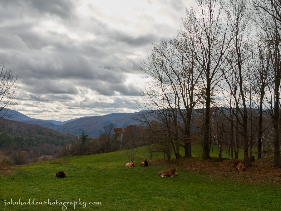
Tuesday, November 10, 2015

Jersey heifers enjoy the mid-morning sunshine on Taft Hill yesterday
Morning Observation:
This morning in Huntington at 6:55AM it’s currently a frosty 27 degrees under clear skies. Winds are calm. Relative humidity is 96%, dewpoint 26, barometric pressure 30. 25”. Yesterday’s high was 54, and the overnight low was 27.
Forecast:
The high pressure that’s been delivering the past few day’s worth of tranquil weather will dish up one more today before sliding to our east. An upper level disturbance approaching from the Ohio Valley will bring some light rain tonight
into Wednesday morning. A more potent frontal system will bring more rain Thursday into Thursday night.
We’ll see partly sunny skies today with highs in the mid 50s and light and variable winds. Tonight should be mostly cloudy with a 50% chance of rain. Lows will be in the upper 30s with light and variable winds.
Wednesday should be cloudy with a 50% chance of rain in the morning, then a chance of showers in the afternoon. Highs will be in the upper 40s with light and variable winds. Wednesday night should be mostly cloudy with lows in the upper 30s and light and variable winds.
The aforementioned upper trough and associated surface low move east from the Great Lakes and Ohio Valley on Thursday bringing widespread rain. Highs will be around 50 with southeast winds 15 to 20 mph. Chance of rain is 80%. Thursday night showers are likely. Lows will be in the lower 40s. Chance of rain is 70%.
Almanac:
Last year on this date we had a high of 50 and a low of 33.
Burlington averages for this date are highs of 48 and lows of 33.
The record high was 74°F in 1948.
The record low was 15°F in 1991.
Sky Notes:
Sunrise: 6:40 AM EST
Sunset: 4:30 PM EST
Length of Visible Light: 10h 51m
Length of Day: 9h 49m
Tomorrow will be 2m28s shorter.
The Moon is a waning crescent, 28d 11h old with 1% illumination.
Moonrise: 5:22 AM EST
Moonset: 4:16 PM EST
About Today’s Photo:
Another angle on one of my favorite places to take photos: these Jersey heifers were enjoying the mid-morning sunshine on Taft Hill yesterday. Even the red oaks that populate the mid-ground hillside are bare now.
Panasonic Lumix GM5, Lumix 14-140mm lens @ 28mm, ISO 400, f/16, 1/200″ exposure.
Monday, November 9, 2015

Frosted Queen Anne’s lace
Morning Observation:
This morning in Huntington at 6:55AM it’s currently a frosty 28 degrees under clear skies. Winds are calm. Relative humidity is 96%, dewpoint 27, barometric pressure 30.39”. Yesterday’s high was 48, and the overnight low was 27.
Forecast:
Surface high pressure over the region will continue to deliver dry weather and seasonably mild temperatures today and through most of tomorrow. A coastal low will bring a chance for rain showers late Tuesday into Tuesday night. We’ll see sunny skies today with highs in the lower 50s and south winds around 10 mph. Tonight should be clear with lows in the lower 30s and southwest winds around 10 mph until midnight, becoming light and variable.
Tuesday should be partly sunny with highs in the lower 50s and light and variable winds. Tuesday night should be cloudy with a 50% chance of rain as the low moves up the coast. Lows will be in the upper 30s with east winds around 10 mph.
Wednesday’s looking mostly cloudy with a 40% chance of showers. Highs will be in the upper 40s with north winds around 10 mph. Wednesday night should be partly cloudy with lows in the mid 30s.
Almanac:
Last year on this date we had a high of 44 and a low of 28.
Burlington averages for this date are highs of 48 and lows of 33.
The record high was 68°F in 2011 (we had a high of 70).
The record low was 12°F in 1971.
Sky Notes:
Sunrise: 6:39 AM EST
Sunset: 4:31 PM EST
Length of Visible Light: 10h 53m
Length of Day: 9h 52m
Tomorrow will be 2m30s shorter.
The Moon is a waxing crescent (hanging prettily in the eastern sky this morning) 27d 11h old with 5% illumination.
Moonrise: 4:24 AM EST
Moonset: 3:46 PM EST
About Today’s Photo:
A tightly packed Queen Anne’s lace seed head sports a mantle of frost in the early morning.
Panasonic Lumix GM5, Lumix 30mm macro lens, ISO 400, f/2.8, 1/1300″ exposure.
Friday, November 6, 2015

Red oak leaves hold there color close to the ground
Morning Observation:
This morning in Huntington at 7:20AM it’s currently a balmy 63 degrees under overcast skies. Winds are calm. Relative humidity is 85%, dewpoint 58, barometric pressure 29. 86” and falling rapidly. Yesterday’s high was a lovely 72, and the overnight low was 61.
Forecast:
A strong southerly flow will keep temperatures mild today out ahead of an approaching cold front that will cross the area this afternoon and evening bringing scattered to numerous showers. We’ll see mostly cloudy skies with a chance of showers mainly this afternoon. Highs will be in the upper 60s with southwest winds 15 to 20 mph gusting up to 35 mph. Chance of rain is 40%. Tonight should be partly cloudy with a slight chance of showers until midnight. Lows will be in the lower 40s with west winds 10 to 15 mph gusting up to 25 mph. Chance of rain is 20%.
Saturday should be partly sunny in the morning, then become mostly cloudy with a 20% chance of rain showers in the afternoon as an upper level trough slides through. It will be more seasonable with highs in the upper 40s and west winds 10 to 15 mph. Saturday night should be mostly cloudy with lows in the lower 30s nd northwest winds 10 to 15 mph.
Sunday’s looking mostly sunny with highs around 40 and northwest winds 10 to 15 mph. Sunday night should be clear with lows around 30.
Almanac:
Last year on this date we had a high of 48 and a low of 38. We picked up 0.02″ of rain.
Burlington averages for this date are high of 49 and lows of 43.
The record high was 75°F in 1948.
The record low was 13°F in 1951.
Sky Notes:
Sunrise: 6:35 AM EST
Sunset: 4:35 PM EST
Length of Visible Light: 11h 01m
Length of Day: 9h 59m
Tomorrow will be 2m35s shorter.
The Moon is a waning crescent, 24d 12h old with 23% illumination.
Moonrise: 1:31 AM EST
Moonset: 2:23 PM EST
About Today’s Photo:
There’s still a little color here and there in the woods. Red oak leaves on tiny, ground hugging saplings still glow bright against the tawny forest floor.
Panasonic Lumix GM5, Olympus 9-18mm lens @ 18mm, ISO 800, f/16, 1/160″ exposure.
Thursday, November 5, 2015

Red oaks holding on to the last of the fall color
Morning Observation:
This morning in Huntington at 6:45AM it’s currently a balmy 50 degrees under mostly clear skies. Winds are calm. Relative humidity is 87%, dewpoint 46, barometric pressure 30.19”. Yesterday’s high was 65, and the overnight low was 46.
Forecast:
A mid-level ridge will crest over the region today with southwest airflow that will deliver another unseasonably warm and dry day. We’ll see partly sunny skies with highs in the upper 60s and southwest winds around 10 mph. Tonight should be partly cloudy with a slight chance of showers until midnight, then mostly cloudy after midnight as a trough of low pressure and associated cold front out over the Great Lakes heads in our direction. Lows will be in the mid 50s with south winds 10 to 15 mph. Chance of rain is 20%.
Friday should be cloudy with a 50% chance of showers as the cold front moves in. Highs will again be quite mild—in the mid 60s—with south winds 15 to 20 mph gusting up to 30 mph. Friday night should be partly cloudy with a 40% chance of showers. Lows will be in the mid 40s with west winds 15 to 20 mph gusting up to 30 mph.
Saturday looking partly sunny and more seasonable with highs in the upper 40s and west winds 10 to 15 mph. Saturday night should be partly cloudy with a 30% chance of rain or snow showers. Lows will be in the lower 30s.
Almanac:
Last year on this date we had a high of 61 and a low of 41. We picked up 0.08″ of rain.
Burlington averages for this date are high of 50 and lows of 34.
The record high was 72°F in 1938.
The record low was 18°F in 1965.
Sky Notes:
Sunrise: 6:34 AM EST
Sunset: 4:36 PM EST
Length of Visible Light: 11h 03m
Length of Day: 10h 02m
Tomorrow will be 2m36s shorter.
The Moon is a waning crescent, 23d 11h old with 31% illumination.
Moonrise: 12:33 AM EST
Moonset: 1:56 PM EST
About Today’s Photo:
Red oaks on the hillside above Handy Road are holding the last of fall’s color. Even now they’re turning browner and losing their coppery luster.
Panasonic Lumix GM5, Lumix 14-140mm lens @ 92mm, ISO 400, f/14, 1/80s exposure.
Wednesday, November 4, 2015
Jersey heifers relax on the top of Taft Hill
Morning Observation:
This morning in Huntington at 6:45AM it’s currently a frosty 32 degrees under clear skies. Winds are calm. Relative humidity is 97%, dewpoint 31, barometric pressure 30.36”. Yesterday’s high was a lovely 65, and the overnight low was 32.
Forecast:
We have another lovely day on tap courtesy of high pressure currently sitting over the region. We’ll see sunny skies with highs in the upper 50s and light and variable winds. Tonight should be clear with lows in the mid 40s and light and variable winds.
Thursday should be partly sunny and seasonably mild as a warm front moves through the region out ahead of approaching low pressure. Highs will be in the mid 60s with light and variable winds. Thursday night should be mostly cloudy with lows in the mid 50s and south winds around 10 mph.
The aforementioned low pressure centered over James Bay will drag a cold front through the region on Friday bringing cloudy skies with a 50% chance of showers. Highs will be in the mid 60s out ahead of the front with south winds 10 to 15 mph gusting up to 30 mph. Friday night should be partly cloudy with a 50% chance of showers. Lows will be in the mid 40s.
Almanac:
Last year on this date we had a high of 62 and a low of 28.
Burlington averages for this date are high of 50 and lows of 34.
The record high was 73°F in 1982.
The record low was 20°F in 2013 (we had a low of 15).
Sky Notes:
Sunrise: 6:32 AM EST
Sunset: 4:37 PM EST
Length of Visible Light: 11h 05m
Length of Day: 10h 05m
Tomorrow will be 2m38s shorter.
The Moon is a waning crescent, 22d 11h old with 41% illumination.
No Moon Rise
Moonset: 1:26 PM EST
About Today’s Photo:
Taft Hill is a favorite spot of mine to take in the view of the Huntington River valley looking south. This group of Jersey heifers were hanging out to make the shot just that much more picturesque.
Panasonic Lumix GM5, Lumix 14-140mm lens @ 24mm, ISO 400, f/14, 1/200″ exposure.
Tuesday, November 3, 2015

Oaks still brighten the hillsides
Morning Observation:
This morning in Huntington at 6:40AM it’s currently 42 degrees under mostly cloudy skies. Winds are calm. Relative humidity is 96%, dewpoint 41, barometric pressure 30.08”. Yesterday’s high was 56, and the overnight low was 36.
Forecast:
We’ve got a lovely day on tap courtesy of a warm front that will lift though the region during the day, followed by a weak surface cold front later in the day. We’ll see partly sunny skies with highs in the lower 60s and southwest winds around 10 mph becoming northwest this afternoon. Tonight should be partly cloudy with lows around 40 and light and variable winds.
Wednesday should be partly sunny in the morning then clear. Highs will be in the upper 50s with light and variable winds. Wednesday night should be clear with lows in the lower 40s and light and variable winds.
Thursday’s looking partly sunny with highs in the lower 60s and south winds around 10 mph. Thursday night should be mostly cloudy with lows in the lower 50s.
Almanac:
Last year on this date we had a high of 47 and a low of 25.
Burlington averages for this date are highs of 51 and lows of 34.
The record high was 74°F in 1982.
The record low was 12°F in 1920.
Sky Notes:
Sunrise: 6:31 AM EST
Sunset: 4:39 PM EST
Length of Visible Light: 11h 08m
Length of Day: 10h 07m
Tomorrow will be 2m39s shorter.
The Moon is in its last quarter, 21d 11h old with 50% illumination.
Moonrise: 11:34 PM EST
Moonset: 12:53 PM EST
About Today’s Photo:
We’re down to oaks and the occasional aspen still contributing some color to the hillsides. This view from Stagecoach Road up Bert White Road looks west. You can just make out the a bit of the Adirondacks as a faint bluish line blending with the clouds.
Panasonic Lumix GM5, Lumix 14-140mm lens @ 46mm, ISO 400, f/14, 1/100″ exposure.
Monday, November 2, 2015

Frost crystals cling to wild a wild raspberry leaf by the pond
Morning Observation:
This morning in Huntington at 6:45AM it’s currently 47 degrees under cloudy skies. Winds are calm. Relative humidity is 87%, dewpoint 43, barometric pressure 30.00” and rising rapidly. We picked up 0.07” of rain in the past 24hrs. Yesterday’s high was 54, and the overnight low was 45.
Forecast:
High pressure will move into the region today bringing dry, tranquil weather along with some clouds and high temperatures in the 50s. A weak warm front will pass through the region on Tuesday with temperatures trending 10 to 15 degrees above normal Tuesday right through Friday.
We’ll see mostly cloudy skies today with highs in the lower 50s and northwest winds 10 to 15 mph. Tonight should be partly cloudy until midnight, then become mostly clear. Lows will be in the upper 30s with light and variable winds, becoming southeasterly around 10 mph after midnight.
Tuesday should be mostly sunny and mild with highs around 60 and south winds 10 to 15 mph, becoming westerly in the afternoon. Tuesday night should be partly cloudy with lows in the lower 40s and north winds around 10 mph.
Wednesday’s looking sunny with highs around 60 and light and variable winds. Wednesday night should be clear with lows in the mid 40s.
Almanac:
Last year on this date we had a high of 40 and a low of 28. We picked up 0.17″ of rain.
Burlington averages for this date are highs of 51 and lows of 35.
The record high was 75°F in 1950.
The record low was 15°F in 1951.
Sky Notes:
Sunrise: 6:30 AM EST
Sunset: 4:40 PM EST
Length of Visible Light: 11h 11m
Length of Day: 10h 10m
Tomorrow will be 2m41s shorter.
The Moon is waning gibbous, 20d 11h old with 60% illumination.
Moonrise: 10:35 PM EST
Moonset: 12:16 PM EST
About Today’s Photo:
Another shot from Saturday’s frosty morning. These crystals grew long and spiny on a wild raspberry leaf by the pond.
Panasonic Lumix GM5, Lumix 30mm macro lens, ISO 400, f/5, 1/320″ exposure.
Sunday, November 1, 2015

Frosted asters in the front field yesterday morning.
Rabbit-rabbit!
Morning Observation:
This morning in Huntington at 7:55 Eastern Standard Time (did everyone remember to set their clocks back?), it’s currently 47 degrees and raining lightly under overcast skies. Winds are out of the southwest at 0-4 mph. Relative humidity 82%, dewpoint 41, barometric pressure 29.82” and falling rapidly. We picked up 0.02” of rain overnight. Yesterday’s high was 47, and the overnight low was 39.
Forecast:
An upper level trough moving along the Canadian border will generate areas of light rain mainly this morning. Clouds will persist, and wind gusts will approach 35 miles per hour in northern New York and parts of the Champlain Valley. High pressure will return Monday leading to dry conditions with above normal temperatures during the next 5 to 7 days.
We’ll see cloudy skies with showers likely mainly this morning. Highs will be in the lower 50s with southwest winds 15 to 20 mph. Chance of rain is 70%. Tonight should be cloudy with a 20% chance of showers until midnight. Lows will be in the lower 40s with west winds 10 to 15 mph.
Monday should start out cloudy in the morning, then becoming partly sunny as high pressure builds in. Highs will be in the lower 50s with west winds around 10 mph in the morning, becoming light and variable. Monday night should be partly cloudy with lows in the lower 40s and light and variable winds.
Tuesday’s looking partly sunny with highs around 60 and southwest winds around 10 mph. Tuesday night should be partly cloudy with lows in the lower 40s.
Almanac:
Last year on this date we had a high of 38 and a low of 30.
Burlington averages for this date are highs of 51 and lows of 35.
The record high was 71°F in 1950.
The record low was 19°F in 1951.
Sky Notes:
Sunrise: 6:28 AM EST
Sunset: 4:41 PM EST
Length of Visible Light: 11h 13m
Length of Day: 10h 13m
Tomorrow will be 2m43s shorter.
The Moon is waning gibbous, 19d 13h old with 70% illumination.
Moonrise: 9:35 PM EST
Moonset: 11:33 AM EST
About Today’s Photo:
Yesterday’s chilly start made for some lovely shots of frosted plants. These dried asters were just catching the first of the morning sunlight.
Panasonic Lumix GM5, Lumix 30mm macro lens, ISO 400, f/4, 1/3200″ exposure.
