Thursday, August 31, 2023

 Rain and sunshine on Knight Island
Morning Observation:
This morning in North Hero at 6:40AM it’s currently 54 degrees under clear skies. Winds are out of the north at 2-4 mph. Relative humidity is 90%, dewpoint 51, barometric pressure 29.93”. We picked up 0.36” of rain yesterday. Yesterday’s high was 72, and yesterday’s low was 61. The overnight low got down to 54.
This morning in Huntington it’s currently 52 degrees under mostly clear skies. Winds are calm. Relative humidity is 97%, dewpoint 51, barometric pressure 29.93”. We picked up 0.60” of rain yesterday. Yesterday’s high was 78, and yesterday’s low was 58. The overnight low got down to 49.
Forecast Discussion:
Well folks, I’ve been waiting for this moment for most of the summer now, and I think it’s finally safe to say that we’ve got an extended period of dry weather ahead of us! High pressure building into the region will dominated our weather clear through the weekend and through the middle of next week. We’re talking 5, maybe even 6 days! Woo-hoo! The last time we had more than 2 consecutive days of dry weather in Huntington was June 23, so this is looooong overdue. Today will feel a bit fall-like with steady northwest winds and temperatures only in the mid 60s to near 70 under clear skies. Temperatures will begin to rebound heading into the weekend with seasonable conditions expected. By Labor Day, we should begin to see daytime highs push well above seasonal norms with highs in the upper 80s to near 90 by Wednesday. So, despite this being the last day of meteorological summer, summer isn’t quite done with us! The next chance of rain looks to be in the Thursday-Friday timeframe next week.
3-Day Forecast:
We’ll see sunny skies today with a high near 68 and northwest winds 5-10 mph in Huntington and 9-17 mph over Lake Champlain. Tonight should be mostly clear with a low around 48 in Huntington and 55 in North Hero with west winds 7-9 mph.
Friday should be sunny with a high near 75 with south winds around 5 mph becoming light and variable in the afternoon. Friday night should be mostly clear with a low around 57 and south winds 9-14 mph.
Saturday should be mostly sunny with a high near 79 and south winds 5-9 mph in Huntington and 11-15 mph over Lake Champlain. Saturday night should be partly cloud, with a low around 63 and south winds 8-11 mph.
Almanac:
Last year on this date in Huntington we had a high of 75 and a low of 54. We picked up 0.07″ of rain.
Last year in North Hero we had a high of 76 and a low of 62. We picked up 0.03″ of rain.
Burlington averages for this date are a low of 58 and a high of 78.
The record low was 35 in 1976.
The record high was 92 in 2010 (we had a high of 89 in Huntington).
The Lake Champlain lake level in Burlington is 98.03′.
The water temperature is 71˚.
Last year’s lake level was at 94.38′.
Sky Notes:
Sunrise: 6:13AM
Sunset: 7:30PM
Length of day: 13:16:53
Today will be 2:55 shorter than yesterday.
The Moon is waning gibbous, 15 days old with 99% illumination.
Moonrise: 8:13PM
Moonset: 6:37AM
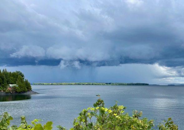
About Today’s Photo:
The view from our lakeside porch did not disappoint yesterday (well it never does…) with steely rain clouds passing through bringing some heavy downpours yesterday afternoon. Sunshine managed to pop out at one point painting Knight Island with light and making it pop against the slate grey of the rain behind it.
iPhone 12 Pro
Wednesday, August 30, 2023

 A spider’s web suspended in the air
Morning Observation:
This morning in North Hero at 7:30AM it’s currently 69 degrees under overcast skies. Winds are out of the south at 5-7 mph. Relative humidity is 93%, dewpoint 67, barometric pressure 29.61”. We picked up 0.26” of rain yesterday. Yesterday’s high was 76, and yesterday’s low was 67. The overnight low got down to 67.
This morning in Huntington it’s currently 66 degrees and just starting to rain under overcast skies. Winds are calm. Relative humidity is 98%, dewpoint 66, barometric pressure 29.66”. We picked up 0.03” of rain yesterday and 0.02” so far today. Yesterday’s high was 82, and yesterday’s low was 60. The overnight low got down to 64.
Forecast Discussion:
Morning radar imagery shows an area of low pressure just about over Toronto at this hour with a swath of showers pushing eastward across Vermont. Widespread showers and a few embedded thunderstorms should move through relatively quickly during the morning hours with a dry slot expected midday. The aforementioned low will then drag a cold front through the region this afternoon bringing renewed chances for showers and thunderstorms. Showers and thunderstorms should wind down towards evening with a few higher elevation showers persisting into the overnight hours. Much cooler air is expected to move in behind the departing front for Thursday with cool, fall-like conditions expected with highs only in the upper 60s to around 70. High pressure will build in for the upcoming weekend allowing temperatures to rebound to more seasonable levels over the weekend with dry conditions expected at least through next Wednesday along with a significant warm-up expected heading into the middle of next week. Highs by Tuesday are expected to push into the upper 80s to near 90 with increasing humidity.
3-Day Forecast:
We’ll see mostly cloudy skies today with showers and possibly a thunderstorm this morning, then a chance of showers and thunderstorms this afternoon. Highs will be near 75 with south winds 5-10 mph becoming northwesterly in the afternoon. Chance of precipitation is 100% with rainfall amounts between 0.50”-0.75” possible. Tonight should be mostly cloudy with a 30% chance of showers, mainly before 10:00PM. Lows will be around 51 with northwest winds 8-13 mph in Huntington and 15-20 mph over Lake Champlain.
Thursday should be sunny with a high near 68 and northwest winds 6-10 mph in Huntington and 9-14 mph over Lake Champlain. Thursday night should be clear with a low around 50 and light west winds.
Friday should be sunny with a high near 76 and south winds 3-5 mph. Friday night should be mostly clear with a low around 53 and south winds 5-10 mph after midnight.
Almanac:
Last year on this date in Huntington we had a high of 87 and a low of 65. We picked up 0.30″ of rain.
Last year in North Hero we had a high of 82 and a low of 66. We picked up 1.52″ of rain.
Burlington averages for this date are a low of 58 and a high of 78.
The record low was 39 in 1965.
The record high was 93 in 1991.
The Lake Champlain lake level in Burlington is 97.99′.
The water temperature is 71˚.
Last year’s lake level was at 94.24′.
Sky Notes:
Sunrise: 6:12AM
Sunset: 7:32PM
Length of day: 13:19:49
Today will be 2:55 shorter than yesterday.
The Moon is the full “Sturgeon” moon (Northeast Native American). It’s also a “blue moon” being the second full moon in August.
14 days old with 100% illumination.
Moonrise: 7:49PM
Moonset: 5:12AM
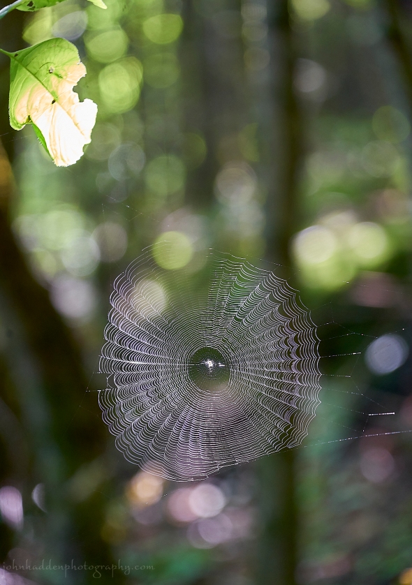
About Today’s Photo:
We came across this orb weaver spiderweb in the forest at Eagle Mountain the other day. The sun was just catching it through the trees.
Sony A7II, Sony 24-240mm lens @ 178mm, ISO 1250, f/6.3, 1/40″ exposure
Tuesday, August 29, 2023

 The view from Eagle Mountain in Milton
Morning Observation:
This morning in North Hero at 7:15AM it’s currently 68 degrees under mostly cloudy skies. Winds are out of the south at 7-10 mph. Relative humidity is 93%, dewpoint 66, barometric pressure 29.92”. Yesterday’s high was 77, and yesterday’s low was 60. The overnight low got down to 67.
This morning in Huntington it’s currently 64 degrees under mostly cloudy skies. Winds are calm. Relative humidity is 98%, dewpoint 63, barometric pressure 29.96”. Yesterday’s high was 80, and yesterday’s low was 49. The overnight low got down to 60.
Forecast Discussion:
Unsettled weather will be the rule over the next 48 hours or so as the remnants of weak trough lift through the region today bringing widely scattered showers during the day, mostly over northern sections. Chances for showers and thunderstorms will increase tonight as low pressure and an associated cold front approach the region from the Great Lakes and slide through during the day on Wednesday. Showers are expected to become widespread towards daybreak on Wednesday, continue through the day, and wind down by Wednesday evening. Cool and dry conditions will move in behind the departing cold front for Thursday bringing a fall-like day on northwest winds. Temperatures are expected to return to seasonable levels heading into the weekend, with a warming trend expected in the Monday-Wednesday timeframe. At this point, it looks like dry conditions will be with us through most of next week!
3-Day Forecast:
We’ll see partly sunny skies today with a 20% chance of showers and afternoon thunderstorms. Highs will be near 78 with south winds 7-12 mph. Tonight should be cloudy with a 60% chance of showers and thunderstorms. Lows will be around 64 with south winds 5-9 mph. Rainfall amounts between 0.25″-0.50″ are possible.
Wednesday should be cloudy with showers and afternoon thunderstorms. Highs will be near 73 with northwest winds 5-10 mph in the afternoon. Chance of precipitation is 90% with rainfall amounts between 0.25″-0.50″ possible. Wednesday night should be mostly cloudy with a 40% chance of showers before 10:00PM. Lows will be around 53 with northwest winds 8-11 mph. Rainfall amounts of less than 0.10″ are possible.
Thursday should be mostly sunny with a high near 69 and northwest winds 7-10 mph. Thursday night should be mostly clear with a low around 47 in Huntington and 56 in North Hero with south winds 5-7 mph.
Almanac:
Last year on this date in Huntington we had a high of 86 and a low of 61.
Last year in North Hero we had a high of 82 and a low of 72.
Burlington averages for this date are a low of 59 and a high of 79.
The record low was 39 in 1941.
The record high was 97 in 2018 (we had a high of 91 in Huntington.
The Lake Champlain lake level in Burlington is 98.06′.
The water temperature is 71˚.
Last year’s lake level was at 94.31′.
Sky Notes:
Sunrise: 6:11AM
Sunset: 7:33PM
Length of day: 13:22:44
Today will be 2:54 shorter than yesterday.
The Moon is waxing gibbous, 12.7 days old with 95% illumination.
Moonrise: 7:21PM
Moonset: 3:45AM
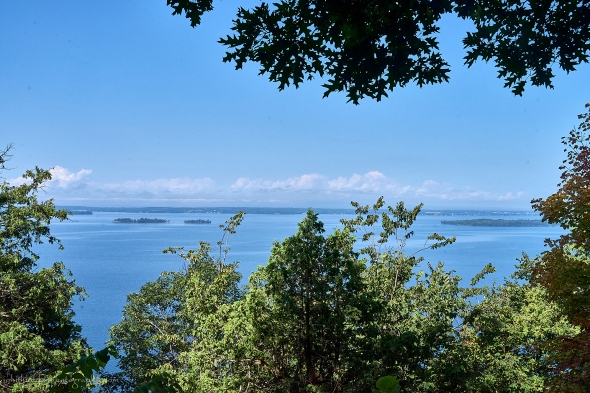
About Today’s Photo:
We took a little hike on Eagle Mountain in Milton yesterday. This lovely preserved natural area on the east shore of Lake Champlain features the highest point on the Lake, offering a nice view to the west from “Hoyt Lookout” near the summit. From the view you can see Fish Bladder Island and the south end of Savage Island along with the opening of Keeler Bay and the Adirondacks behind. The park owned by the Town of Milton through a partnership with the Lake Champlain Land Trust and is well worth a visit with several trails meandering through calcareous forests with large boulders and moss covered ledges.
Sony A7II, Sony 24-240mm lens @ 32mm, ISO 800, f/14, 1/1250″ exposure.
Monday, August 28, 2023

 A great blue heron stakes out our neighbor’s point
Morning Observation:
This morning in North Hero at 7:10AM it’s currently 61 degrees under mostly cloudy skies with some impressive valley fog across that water. Winds are out of the south at 2-4 mph. Relative humidity is 94%, dewpoint 59, barometric pressure 30.02”. Yesterday’s high was 73, and yesterday’s low was 61. The overnight low got down to 60.
This morning in Huntington it’s currently 50 degrees under mostly cloudy skies. Winds are calm. Relative humidity is 98%, dewpoint 49, barometric pressure 30.07”. We picked up 0.33” of rain yesterday. Yesterday’s high was 71, and yesterday’s low was 53. The overnight low got down to 49.
Forecast Discussion:
Dense valley fog is expected to burn off by mid-morning with sunny skies and seasonable temperatures expected for today under high pressure. A weak trough lifting out of the south will bring renewed chances for showers later tonight on-and-off through Tuesday. Showers will increase Tuesday night into Wednesday morning as a cold front swings through the region. Cool high pressure is expected to move in behind the departing front Wednesday night with dry and seasonably cool conditions expected for Thursday. Temperatures are expected to rebound heading into the weekend with dry and seasonable conditions expected through the Labor Day weekend and into at least early next week. We’re talking dry weather for at least 5-6 days folks!
3-Day Forecast:
We’ll see patchy dense fog this morning giving way to sunny skies with a high near 77 and south winds 5-8 mph. Tonight should be mostly cloudy with a 40% chance of showers, mainly after 8:00PM. Lows will be around 62 with south winds 7-10 mph. Rainfall amounts of less 0.10″-0.25″ are possible.
Tuesday should be partly sunny with a 40% chance of showers. Highs will be near 78 with south winds 7-10 mph. Rainfall amounts of 0.10″-0.25″ are possible. Tuesday night should be mostly cloudy with a 40% chance of showers. Lows will be around 62 with south winds 3-6 mph. Rainfall amounts between 0.10″-0.25″ are possible.
Wednesday should be partly sunny with a 50% chance of showers. Highs will be near 72 with northwest winds 5-10 mph. Rainfall amounts between 0.10″-0.25″ are possible. Wednesday night should be partly cloudy with a low around 52 with northwest winds around 10 mph.
Almanac:
Last year on this date in Huntington we had a high of 84 and a low of 48.
Last year in North Hero we had a high of 80 and a low of 62.
Burlington averages for this date are a low of 59 and a high of 79.
The record low was 39 in 1957.
The record high was 94 in 1952.
The Lake Champlain lake level in Burlington is 98.16′.
The water temperature is 69˚.
Last year’s lake level was at 94.33′.
Sky Notes:
Sunrise: 6:10AM
Sunset: 7:35PM
Length of day: 13:25:39
Today will be 2:53 shorter than yesterday.
The Moon is waxing gibbous, 11.5 days old with 88% illumination.
Moonrise: 6:46PM
Moonset: 2:21AM
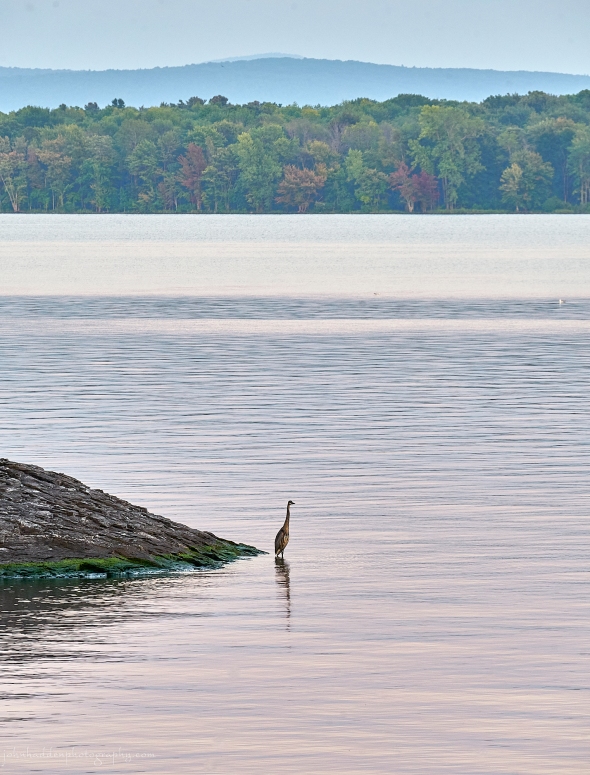
About Today’s Photo:
As is often the case, one of our local great blue herons came to picturesquely take up its position on our neighbor’s point across the cove last evening. There are a couple of other things to note in the photo: the silver maples along the shore of Knight Island across the water are turning, and the fringe of bright green algae along the shoreline attest to the lake level finally starting to drop consistently.
Sony A7II, Sigma 100-400mm lens @ 278mm, ISO 1250, f/13, 1/30″ exposure.
Sunday, August 27, 2023

 Evening cumulus clouds over the northern Green Mountains
Morning Observation:
This morning in North Hero at 7:45AM it’s currently 61 degrees under mostly cloudy skies. Winds are light out of the north. Relative humidity is 95%, dewpoint 60, barometric pressure 29.97”. We picked up 0.70” of rain yesterday. Yesterday’s high was 78, blew 63. The overnight low got down to 61.
This morning in Huntington it’s currently 60 degrees under overcast skies. Winds are calm. Relative humidity is 97%, dewpoint 59, barometric pressure 29.96”. We picked up 0.20” of rain yesterday and 0.33” so far today. Yesterday’s high was 76, and yesterday’s low was 62. The overnight low got down to 60.
Forecast Discussion:
Outside of a few scattered terrain driven showers this morning, morning clouds should give way to mostly sunny skies today with light north winds as high pressure builds into the region bringing dry and seasonable conditions today and Monday. Clouds will be on the increase Monday night as a weak shortwave trough slides through bringing chances for showers later Monday night and through much of Tuesday. This isn’t a particularly organized system, so showers look to be limited, even mixing with partial sunshine on Tuesday. Some scattered showers are expected to linger into Wednesday morning before high pressure builds in for the latter part of the week bringing an extended period of dry and seasonable conditions through the weekend and into next week(!!!)
3-Day Forecast:
We’ll see cloudy skies this morning giving way to mostly sunny skies with a high near 72 and northwest winds 3-8 mph. Tonight should be partly cloudy with a low around 54 and light and variable winds.
Monday should be mostly sunny with a high near 76 and south winds 5-7 mph. Monday night should be partly cloudy with a 30% chance of showers late. Lows will be around 60 with south winds 5-7 mph. Rainfall amounts between 0.10″-0.25″ are possible.
Tuesday should start off mostly cloudy with a 30% chance of morning showers. Skies should become partly sunny with a high near 78 and south winds around 8 mph. Rainfall amounts between 0.10″-0.25″ are possible. Tuesday night should be mostly cloudy with showers likely. Lows will be around 58 with south winds 6-8 mph. Chance of precipitation is 70% with rainfall amounts between 0.25″-0.50″ possible.
Almanac:
Last year on this date in Huntington we had a high of 75 and a low of 52.
Last year in North Hero we had a high of 74 and a low of 60.
Burlington averages for this date are a low of 59 and a high of 79.
The record low was 40 in 1969.
The record high was 95 in 1948.
The Lake Champlain lake level in Burlington is 98.22′.
The water temperature is 70˚.
Last year’s lake level was at 94.39′.
Sky Notes:
Sunrise: 6:08AM
Sunset: 7:37PM
Length of day: 13:28:32
Today will be 2:53 shorter than yesterday.
The Moon is waxing gibbous, 10.4 days old with 80% illumination.
Moonrise: 6:02PM
Moonset: 1:07AM
About Today’s Photo:
We drove over to Stowe yesterday to help celebrate the life of renowned photographer, author, and Vermont icon, Peter Miller. We drove through occasional showers both there and back, with big, beautiful cumulous clouds blooming. We spotted this cloud rising over the northern Greens (you can just make out Jay Peak underneath it) as we got back onto the islands, and stopped along the shore to grab this shot.
Sony A7II, Sony 24-240mm lens @ 122mm, ISO 800, f/13, 1/400″ exposure.
Saturday, August 26, 2023

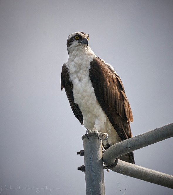 An osprey scans the water from its perch on a navigational marker
Morning Observation:
This morning in North Hero at 7:15AM it’s currently 67 degrees under overcast skies. Winds are out of the south at 2-4 mph. Relative humidity is 95%, dewpoint 65, barometric pressure 29.89”. We picked up 0.02” of rain yesterday. Yesterday’s high was 70, and yesterday’s low was 64. The overnight low got down to 65.
This morning in Huntington it’s currently 63 degrees under overcast skies. Winds are calm. Relative humidity is 98%, dewpoint 63, barometric pressure 29.84”. We picked up 0.76” of rain yesterday and 0.04” so far today. Yesterday’s high was 72, and yesterday’s low was 60. The overnight low got down to 62.
Forecast Discussion:
Low pressure centered north of Quebec City this morning will slowly track eastward during the day today rotating in a series of weak surface troughs that will bring rounds of showers to the region throughout the day today. An embedded cold front is expected to swing through the region sometime this afternoon setting off of few scattered afternoon thunderstorms as well. Showers should wind down later this evening though some higher elevation showers may persist into Sunday morning before high pressure builds in clearing things out. Dry and seasonable conditions are expected for Monday and into Tuesday. Low pressure approaching from the Great Lakes on Tuesday will bring increasing chances for showers Tuesday afternoon with more widespread rains and some thunderstorms expected Tuesday night into Wednesday morning. Dry and seasonably cool conditions are expected to end the week with a dry weekend expected (at this point) for the Labor Day weekend.
3-Day Forecast:
We’ll see cloudy skies today with a 60% chance of showers and afternoon thunderstorms. Highs will be near 74 light south winds becoming northwesterly 6-10 mph in the afternoon. Rainfall amounts between 0.10″-0.25″ are possible with higher amounts possible in thunderstorms. Tonight should be cloudy with showers likely, mainly before 11:00PM. Lows will be around 57 with north winds 5-10 mph. Chance of precipitation is 60% with rainfall amounts of less than 0.10″ possible.
Sunday should be partly sunny with a high near 70 and northwest winds 5-9 mph. Sunday night should be mostly clear with a low around 54 and northeast winds around 5 mph becoming light and variable.
Monday should be sunny with a high near 76 and south winds around 6 mph. Monday night should be partly cloudy with a low around 60 and south winds 3-8 mph.
Almanac:
Last year on this date in Huntington we had a high of 76 and a low of 57. We picked up 0.75″ of rain.
Last year in North Hero we had a high of 76 and a low of 57. We picked up 0.40″ of rain.
Burlington averages for this date are a low of 59 and a high of 79.
The record low was 40 in 2987.
The record high was 96 in 1948.
The Lake Champlain lake level in Burlington is 98.15′.
The water temperature is 71˚.
Last year’s lake level was at 94.33′.
Sky Notes:
Sunrise: 6:07AM
Sunset: 7:39PM
Length of day: 13:31:26
Today will be 2:52 shorter than yesterday.
The Moon is waxing gibbous, 9 days old with 70% illumination.
Moonrise: 5:01PM
Moonset: 12:07AM
About Today’s Photo:
We see quite a few ospreys around the lake here each summer. These large, fish-eating raptors nest in elevated structures like trees and manmade platforms (this one was nesting on one of the navigational markers in The Gut by the North Hero drawbridge). One or two will often hunt in our cove—perching on a tree above the water, then diving suddenly talons-first to hopefully snatch a fish from the water. I have yet to capture a photo of that feat! The osprey is the second most widely distributed raptor species, after the peregrine falcon, and is one of only six land-birds with a worldwide distribution.
Sony A7II, Sigma 100-400mm lens @ 400mm, ISO 400, f/8, 1/4000″ exposure.
Friday, August 25, 2023

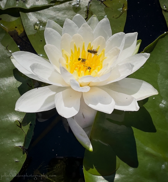 Three flies on a water lily
Morning Observation:
This morning in Huntington at 7:20AM it’s currently 62 degrees under overcast skies. Winds are calm. Relative humidity is 97%, dewpoint 60, barometric pressure 29.84”. We picked up 0.55” of rain yesterday and 0.40” so far today. Yesterday’s high was 79, and yesterday’s low was 48. The overnight low got down to 60.
This morning in North Hero it’s currently 66 degrees under overcast skies. Winds are out of the south at 9-11 mph. Relative humidity is 95%, dewpoint 64, barometric pressure 29.79”. We picked up 0.30” of rain yesterday and 0.01” so far today. Yesterday’s high was 75, and yesterday’s low was 62. The overnight low got down to 64.
Forecast Discussion:
Well, we still haven’t managed to break out of the no-more-than-two-dry-days-in-a-row rainy pattern that we’ve been in since June 23 here in Huntington, and it doesn’t look like we will anytime soon either. Low pressure passing to our south will keep spotty rain showers and low clouds over the region today. Showers should dry up briefly tonight before low pressure passing to our north drags a cold front through the region on Saturday bringing another round of showers and seasonably cool temperatures. Showers should linger into early Sunday as the aforementioned low rotates another weak shortwave through the region, but high pressure building in should make for a mostly dry day and a dry start to next week. Yet more rain is expected in the Wednesday-Thursday timeframe as an upper level trough deepens and crosses the region.
3-Day Forecast:
We’ll see cloudy skies today with a 40% chance of showers. Highs will be near 72 with south winds 5-10 mph, becoming calm in the afternoon. Rainfall amounts between 0.10″-0.25″ are possible. Tonight should be mostly cloudy with a 30% chance of showers. Lows will be around 61 with north winds 3-5 mph. Rainfall amounts between 0.10″-0.25″ are possible.
Saturday should be mostly cloudy with a 50% chance of showers. Highs will be near 73 with northwest winds 5-10 mph. Rainfall amounts between 0.10″-0.25″ are possible. Saturday night should be mostly cloudy with a low around 57 and north winds 5-10 mph.
Sunday should be partly sunny with a high near 71 and north winds 5-10 mph. Sunday night should be mostly clear with a low around 51 in Huntington and 59 in North Hero with north winds around 10 mph.
Almanac:
Last year on this date in Huntington we had a high of 77 and a low of 59.
Last year in North Hero we had a high of 77 and a low of 65.
Burlington averages for this date are a low of 59 and a high of 80.
The record low was 38 in 1943.
The record high was 97 in 1947.
The Lake Champlain lake level in Burlington is 98.20′.
The water temperature is 71˚.
Last year’s lake level was at 94.37′.
Sky Notes:
Sunrise: 6:06AM
Sunset: 7:40PM
Length of day: 13:34:18
Today will be 2:51 shorter than yesterday.
The Moon is waxing gibbous, 8 days old with 60% illumination.
Moonrise: 3:54PM
No Moonset
About Today’s Photo:
We found some water lilies while kayaking in one of the old docking channels near Hero’s Welcome in North Hero the other day. These three flies were enjoying the nectar that the bright white blooms provided.
iPhone 12 Pro
Thursday, August 24, 2023

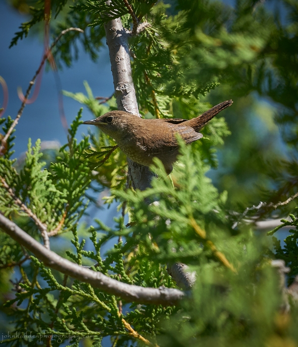 A house wren hunts in the cedars above the water
Morning Observation:
This morning in North Hero at 7:10AM it’s currently 64 degrees under clear skies. Winds are out of the south at 8-10 mph. Relative humidity is 83%, dewpoint 59, barometric pressure 30.01”. Yesterday’s high was 74, and yesterday’s low was 60. The overnight low got down to 63.
This morning in Huntington it’s currently 49 degrees under clear skies. Winds are calm. Relative humidity is 97%, dewpoint 48, barometric pressure 30.06”. Yesterday’s high was 78, and yesterday’s low was 46. The overnight low got down to 48.
Forecast Discussion:
The high pressure that has delivered our past couple of days of nice late summer weather is sliding to the east this morning bringing in some gusty south winds. Clouds will be on the increase during the day today out ahead of low pressure approaching from the southern Great Lake. Showers are expected to move into northern New York by early afternoon and into Vermont later this afternoon/evening with widespread showers expected tonight and into Friday morning as the low tracks through southern New England. Showers should become scattered in nature during the day on Friday, but a low level inversion pushing in from the coast is expected to keep low clouds around pretty much all day with gusty south winds expected. Saturday should start out dry, but a weak cold front is expected to drop through the region during the day bringing renewed chances for showers and a few garden variety thunderstorms. Seasonably cool and dry conditions are expected for Sunday and Monday, with more showers expected sometime midweek. Forecast models are still disagreeing on the timing of this next system with some pointing to some well-below normal temperatures later in the week. Stay tuned…
3-Day Forecast:
We’ll see increasing clouds today with a high near 75 and south winds 5-8 mph in Huntington and 11-18 mph over Lake Champlain. Tonight should be cloudy with showers and possibly a rumble of thunder. Lows willbe around 59 with south winds around 10 mph in Huntington and 20-24 mph over Lake Champlain. Chance of precipitation is 80% with rainfall amounts between 0.25″-0.50″ possible.
Friday should be mostly cloudy with showers and possibly a thunderstorm, mainly before 1:00PM. Highs will be near 70 with south winds 9-11 mph in Huntington and 14-18 mph over Lake Champlain. Chance of precipitation is 70% with rainfall amounts between 0.25″-0.50″ possible. Friday night should be mostly cloudy with a 40% chance of showers. Lows will be around 60 with southeast winds around 5 mph becoming light and variable in the evening. Rainfall amounts of less than 0.10″ are possible.
Saturday should be mostly cloudy with a 50% chance of showers. Highs will be near 70 with northwest winds 5-12 mph. Rainfall amounts between 0.10″-0.25″ are possible. Saturday night should be mostly cloudy with a 30% chance of showers. Lows will be around 54 with northwest winds 7-10 mph. Rainfall amounts of less than 0.10″ are possible.
Almanac:
Last year on this date in Huntington we had a high of 82 and a low of 65. We picked up 0.42″ of rain.
Last year in North Hero we had a high of 79 and a low of 67.
Burlington averages for this date are a low of 60 and a high of 80.
The record low was 41 in 1942.
The record high was 97 in 1947.
The Lake Champlain lake level in Burlington is 98.29′.
The water temperature is 72˚.
Last year’s lake level was at 94.37′.
Sky Notes:
Sunrise: 6:05AM
Sunset: 7:42PM
Length of day: 13:37:10
Today will be 2:50 shorter than yesterday.
The Moon is in its first quarter, 7 days old with 49% illumination.
Moonrise: 2:45PM
Moonset: 11:20PM
About Today’s Photo:
I’ve been keeping my eye (and ears) on a family of house wrens that has been around this summer. You can hear the consistent chatter of the female as she shepherds her three fledglings through the cedars above the water, training them to hunt the many yummy bugs that lurk there. I have a soft spot for wrens. There’s something about their short, bobbing tails that gets to me…
Sony A7II, Sigma 100-400mm lens @ 800, f/8, 1/1000″ exposure
Wednesday, August 23, 2023

 A fine start to the day…
Morning Observation:
This morning in North Hero at 7:25AM it’s currently 64 degrees under clear skies. Winds are out of the south at 2-4 mph. Relative humidity is 86%, dewpoint 60, barometric pressure 30.13”. Yesterday’s high was 76, and yesterday’s low was 57. The overnight low got down to 60.
This morning in Huntington it’s currently 48 degrees under clear skies. Winds are calm. Relative humidity is 97%, dewpoint 47, barometric pressure 30.18”. Yesterday’s high was 74, and yesterday’s low was 45. The overnight low got down to 46.
Forecast Discussion:
We’ve got another lovely late summer day on tap for today as high pressure continues to build into the region. Winds should be light out of the south with highs in the mid to upper 70s under sunny skies. Low pressure tracking out of the Great Lakes will bring increasing clouds on Thursday with showers expected to move into Vermont in the afternoon/evening on gusty south winds. The rain is expected to persist into Friday before winding down in the afternoon with a misty, grey afternoon expected under a southeast maritime airflow. After a dry start to the day on Saturday, a cold front is expected to swing through Saturday afternoon bringing widely scattered showers. Sunday is looking dry and seasonable. At this point, forecast models are in a bit of disagreement heading into next week with unsettled conditions seeming to win out. We’ll have to wait and see…
3-Day Forecast:
We’ll see sunny skies today with a high near 75 and south winds around 6 mph. Tonight should be mostly clear with a low around 54 and south winds 5-10 mph.
Thursday should bring increasing clouds with a 30% chance of showers, mainly after 5:00PM. Highs will be near 73 with south winds 9-14 mph. Rainfall amounts between 0.10″-0.25″ are possible. Thursday night should be cloudy with showers. Lows will be around 58 with southeast winds 12-16 mph gusting to 28 mph. Chance of precipitation is 90% with rainfall amounts between 0.25″-0.50″ possible.
Friday should be cloudy with showers likely, mainly before 1:00PM. Highs will be near 68 with southeast winds 9-13 mph gusting to 24 mph. Chance of precipitation is 70% with rainfall amounts between 0.10″-0.25″ possible. Friday night should be cloudy with a 40% chance of showers. Lows will be around 60 with north winds 3-6 mph. Rainfall amounts of less than 0.10″ are possible.
Almanac:
Last year on this date in Huntington we had a high of 77 and a low of 66. We picked up 0.38″ of rain.
Last year in North Hero we had a high of 75 and a low of 68. We picked up 0.26″ of rain.
Burlington averages for this date are a low of 60 and a high of 80.
The record low was 43 in 1988.
The record high was 93 in 1947.
The Lake Champlain lake level in Burlington is 98.37′.
The water temperature is 70˚.
Last year’s lake level was at 94.32′.
Sky Notes:
Sunrise: 6:04AM
Sunset: 7:44PM
Length of day: 13:40:01
Today will be 2:50 shorter than yesterday.
The Moon is a waxing crescent, 6 days old with 38% illumination.
Moonrise: 1:31PM
Moonset: 10:45PM
About Today’s Photo:
Rising early has its benefits as I was greeted by a lovely waking sky! The distinct profile of Mt. Mansfield can be seen on the right.
iPhone 12 Pro
Tuesday, August 22, 2023

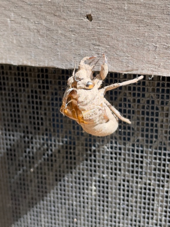
The dried husk of a cicada exuviae
Morning Observation:
This morning in North Hero at 7:40AM it’s currently 64 degrees under mostly clear skies. Winds are light out of the north. Relative humidity is 77%, dewpoint 56, barometric pressure 30.14”. We picked up just a trace of rain yesterday. Yesterday’s high was 74, and yesterday’s low was 62.
This morning in Huntington it’s currently 52 degrees under mostly clear skies. Winds are calm. Relative humidity is 98%, dewpoint 52, barometric pressure 30.17”. We picked up 0.05” of rain yesterday. Yesterday’s high was 72, and yesterday’s low was 55. The overnight low got down to 45.
Forecast Discussion:
We’ve got another dry and seasonably cool day on tap for today courtesy of Canadian high pressure nosing into the region. Rinse and repeat for Wednesday! Clouds will be on the increase later Wednesday out ahead of a large, disorganized area of low pressure approaching the region from the Great Lakes. This low will push into the region later Thursday bringing some scattered showers later Thursday afternoon/evening, through much of Friday, and lingering into Saturday morning. High pressure is expected to return for the remainder of the weekend with another (gasp!) extended period of dry and seasonable weather expected heading into next week.
3-Day Forecast:
We’ll see sunny skies today with a high near 73 and north winds 5-10 mph. Tonight should be partly cloudy with a low around 53 and light winds.
Wednesday should be sunny with a high near 75 and light south winds. Wednesday night should be partly cloudy with a low around 57 and southwest winds 3-7 mph.
Thursday should bring increasing clouds with a 30% chance of afternoon showers. Highs will be near 73 with south winds 5-10 mph in Huntington and 10-15 mph in the Champlain Valley. Rainfall amounts of less than 0.10″ are possible. Thursday night should be cloudy with showers. Lows will be around 58 with southeast wind around 14 mph. Chance of precipitation is 80% with rainfall amounts between 0.25″-0.50″ possible.
Almanac:
Last year on this date in Huntington we had a high of 80 and a low of 64.
Last year in North Hero we had a high of 81 and a low of 71. We picked up 0.01″ of rain.
Burlington averages for this date are a low of 60 and a high of 80.
The record low was 39 in 1982.
The record high was 90 in 1942.
The Lake Champlain lake level in Burlington is 98.41′.
The water temperature is 70˚.
Last year’s lake level was at 94.36′.
Sky Notes:
Sunrise: 6:03AM
Sunset: 7:45PM
Length of day: 13:42:51
Today will be 2:49 shorter than yesterday.
The Moon is a waxing crescent, 5.4 days old with 29% illumination.
Moonrise: 12:19PM
Moonset: 10:19PM
About Today’s Photo:
This is a bit of a follow-up to my post the other day with the adult cicada. Cicadas live underground as nymphs for most of their lives at depths down to about 8 ft. After a period of anywhere from 3 to 17 years (the North American species having the familiar 13 and 17 year cycles), the nymphs emerge from the ground and the adults molt their outer skins leaving a exuviae behind.
iPhone 12 Pro
Monday, August 21, 2023

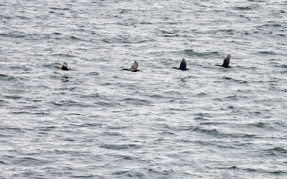 Cormorants in flight across the water
Morning Observation:
This morning in North Hero at 6:45AM it’s currently 69 degrees under overcast skies. Winds are out of the south at 1-2 mph. Relative humidity is 90%, dewpoint 66, barometric pressure 29.98”. Yesterday’s high was 75, and yesterday’s low was 62. The overnight low got down to 69.
This morning in Huntington it’s currently 64 degrees under overcast skies. Winds are calm. Relative humidity is 97%, dewpoint 63, barometric pressure 30.02”. Yesterday’s high was 80, and yesterday’s low was 52. The overnight low got down to 61.
Forecast Discussion:
A weak cold front is poised to drop through the region today, but outside of some morning clouds and sprinkles, we should see a dry and seasonably cool day today as winds turn into the north and high pressure builds into the region. Dry and seasonably cool conditions are expected at least through midweek as high pressure dominates. Yes, we may even get a miraculous more-than-two-day stretch of sunny, late summer weather! The next chance of any appreciable rain looks to hold off until later Thursday into Friday as a trough slides through.
3-Day Forecast:
We’ll see cloudy skies this morning with a 40% chance of morning sprinkles showers. Skies should gradually become mostly sunny with a high near 71 and north winds 5-9 mph in Huntington and 11-17 mph in the Champlain Valley by midday. Tonight should be partly cloudy with a low around 55 and north winds around 6 mph becoming calm in the evening.
Tuesday should be sunny with a high near 74 and north winds 5-9 mph. Tuesday night should be mostly clear with a low around 53 and light and variable winds.
Wednesday should be sunny with a high near 75 and light and variable winds becoming north 5-7 mph in the afternoon. Wednesday night should be partly cloudy with a low around 53 and south winds 3-7 mph.
Almanac:
Last year on this date in Huntington we had a high of 86 and a low of 61.
Last year in North Hero we had a high of 83 and a low of 73.
Burlington averages for this date are a low of 60 and a high of 80.
The record low was 43 in 1941.
The record high was 93 in 1945.
The Lake Champlain lake level in Burlington is 98.44′.
The water temperature is 72˚.
Last year’s lake level was at 94.36′.
Sky Notes:
Sunrise: 6:01AM
Sunset: 7:47PM
Length of day: 13:45:40
Today will be 2:48 shorter than yesterday.
The Moon is a waxing crescent, 4.4 days old with 20% illumination.
Moonrise: 11:11AM
Moonset: 9:58PM
About Today’s Photo:
Double-breasted cormorants have been starting up their “flight training” schools over the past week or so, moving in streams of birds back and forth between Hen Island to our north and City Bay in front of North Hero village. These diving birds have a bit of a checkered past here on Lake Champlain. A native species in North America, cormorants were fairly rare on the Lake as recently as the 1970s. Like most avian species, cormorants populations were decimated by human use of DDT. When DDT was banned in 1972, cormorant populations started to expand in North America, including the waters of Lake Champlain where its population peaked in 1999 at about 9000 nesting pairs. The largest colonies were on Young Island just off the western shore from Grand Isle. Methods to control the populations were attempted and greeted with some success, but populations are again on the rebound. There’s a great article here that you can read for more information on the “Cormorant Conundrum”.
Sony A7II, Sigma 100-400mm lens @ 400mm, ISO 1250, f/6.3, 1/1600″ exposure
Sunday, August 20, 2023

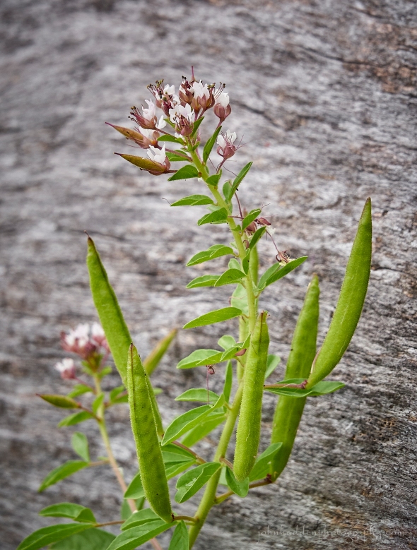 Redwhisker clammyweed blooming along the beach
Morning Observation:
This morning in North Hero at 7:10AM it’s currently 65 degrees under mostly cloudy skies. Winds are out of the south at 7-9 mph. Relative humidity is 84%, dewpoint 60, barometric pressure 29.95”. We picked up 0.44” of rain yesterday. Yesterday’s high was 67, and yesterday’s low was 59. The overnight low got down to 62.
This morning in Huntington it’s currently 54 degrees under mostly cloudy skies. Winds are calm. Relative humidity is 98%, dewpoint 53, barometric pressure 30.02”. We picked up 0.23” of rain yesterday. Yesterday’s high was 65, and yesterday’s low was 57. The overnight low got down to 52.
Forecast Discussion:
High pressure building into the region today will deliver a dry and seasonable day today with highs in the mid 70s to around 80 and gusty south winds. A cold front will drop through the region overnight tonight bringing a slight chances of showers overnight. Dry conditions are expected to continue through much of midweek as high pressure builds in behind the cold front with seasonably cool temperatures expected. The next chance of showers arrives near the end of next week.
3-Day Forecast:
We’ll see sunny skies today with a high near 80 and south winds 6-10 mph. Tonight should be mostly cloudy with a 30% chance of showers towards daybreak. Lows will be around 64 with south winds 3 to 6 mph. Rainfall amounts of less than 0.10″ are possible.
Monday should be mostly cloudy with a 30% chance of morning showers. Skies should gradually become sunny with highs near 75 and north winds 6-14 mph. Monday night should be partly cloudy with a low around 55 and north winds 3-6 mph.
Tuesday should be mostly sunny with a high near 73 with north winds 5-9 mph. Tuesday night should be mostly clear with a low around 49 in Huntington and 58 in North Hero with light and variable winds.
Almanac:
Last year on this date in Huntington we had a high of 89 and a low of 55.
Last year in North Hero we had a high of 84 and a low of 67.
Burlington averages for this date are a low of 60 and high of 80.
The record low was 42 in 1953.
The record high was 92 in 2022 (see above…)
The Lake Champlain lake level in Burlington is 98.49′.
The water temperature is 71˚.
Last year’s lake level was at 94.39′.
Sky Notes:
Sunrise: 6:00AM
Sunset: 7:49PM
Length of day: 13:48:29
Today will be 2:47 shorter than yesterday.
The Moon is a waxing crescent, 3.5 days old with 13% illumination.
Moonrise: 10:05AM
Moonset: 9:40PM
About Today’s Photo:
I love the name of this plant. We usually see quite a lot of it growing along the beach in the summer, but with the water level so high this season, there isn’t a whole lot. The green pods will gradually turn to tan with rattly seeds inside. Eventually, the tops will split open allowing the sesame-seed-sized seeds to escape.
Sony A7II, Sony 24-240mm lens @ 240mm, ISO 1250, f/13, 1/240″ exposure.
Saturday, August 19, 2023

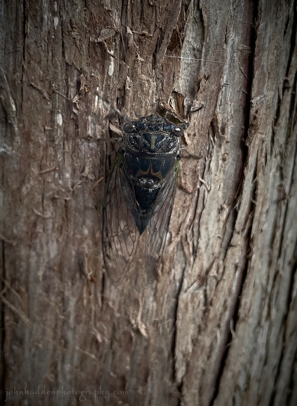 A cicada on a cedar!
Morning Observation:
This morning in North Hero at 7:25AM it’s currently 60 degrees under overcast skies. Winds are out of the south at 3-5 mph. Relative humidity is 93%, dewpoint 57, barometric pressure 29.76”. We picked up 0.07” of rain yesterday and 0.30” so far today. Yesterday’s high was 73, and yesterday’s low was 65. The overnight low got down to 59.
This morning in Huntington it’s currently 58 degrees under overcast skies. Winds are calm. Relative humidity is 97%, dewpoint 57, barometric pressure 29.79”. We picked up 0.14” of rain yesterday and 0.16” so far today. Yesterday’s high was 76, and yesterday’s low was 56. The overnight low got down to 57.
Forecast Discussion:
Morning radar imagery shows low pressure just north o Quebec City at this hour. This low will slowly track northeastward during the day today, rotating scattered showers into the region throughout the day. Highs today will be on the cool side—in the mid to upper 60s to maybe 70 in broader southern valleys of Vermont. High pressure is expected to build in later tonight into Sunday bringing dry and seasonable conditions for Sunday. A quick moving cold front is expected to cross the region Sunday night into Monday bringing another round of showers to the region. Drier and seasonably cool air is expected to move in behind the front bringing perhaps a more-than-two-day stretch of dry weather through midweek! Woo-hoo!
3-Day Forecast:
We’ll see mostly cloudy skies today with a 30% chance of showers, mainly after 3:00PM. Highs will be near 65 with southwest winds -12 mph. Rainfall amounts of less than 0.10″ are possible. Tonight should be cloudy with a 40% chance of showers. Skies should gradually become partly cloudy with a low around 54 in Huntington and 62 in North Hero with southwest winds around 7-14 mph. Rainfall amounts of less than 0.10″ are possible.
Sunday should be mostly sunny with a high near 81 and southwest winds 9-14 mph. Sunday night should be mostly cloudy with a low around 64 and south winds 5-8 mph in Huntington and 10-14 mph in the Champlain Valley.
Monday should be mostly cloudy with a 30% chance of showers before 2:00PM. Highs will be near 75 with north winds 6-12 mph. Rainfall amounts of less than 0.10″ are possible. Monday night should be mostly cloudy with a low around 53 in Huntington and 60 in North Hero with north winds 3-8 mph.
Almanac:
Last year on this date in Huntington we had a high of 85 and a low of 57.
Last year in North Hero we had a high of 79 and a low of 65.
Burlington averages for this date are a low of 61 and a high of 81.
The record low was 40 in 1963.
The record high was 90 in 2015 (we had a high of 87 in Huntington).
The Lake Champlain lake level in Burlington is 98.48′
The water temperature is 72˚.
Last year’s lake level was at 94.44′.
Sky Notes:
Sunrise: 5:59AM
Sunset: 7:50PM
Length of day: 13:51:16
Today will be 2:46 shorter than yesterday.
The Moon is a waxing crescent, 2.6 days old with 7% illumination.
Moonrise: 9:02AM
Moonset: 9:23PM
About Today’s Photo:
I found this cicada on our sidewalk here at camp yesterday evening and decided to give it a safer perch on a nearby cedar tree. I rarely actually get to see a cicada as they’re usually hiding out in the crowns of trees when they sing their distinctive, shrill song. There’s quite a lot to know about cicadas, from the 13 or 17 year cycles of some species, to the pretty accurate “thermometer” of their songs. In my experience, cicadas will start singing at around 75˚ f., and, supposedly, you can tell the temperature by counting the number of chirps in 15 seconds and then add 37 to arrive at an approximate temperature. Give it a try next time you hear one!
iPhone 12 Pro
Friday, August 18, 2023

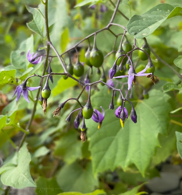 Bittersweet nightshade blooming along the beach
Morning Observation:
This morning in Huntington at 6:30AM it’s currently 67 degrees and just starting to rain under low overcast skies. Winds are calm. Relative humidity is 90%, dewpoint 64, barometric pressure 29.68”. Yesterday’s high was 79, and yesterday’s low was 62. The overnight low got down to 66.
This morning in North Hero it’s currently 69 degrees and raining under overcast skies. Winds are out of the south at 8-10 mph. Relative humidity is 97%, dewpoint 65. Barometric pressure 29.62”. We picked up 0.01” of rain so far today. Yesterday’s high was 76, and yesterday’s low was 69. The overnight low got down to 68.
Forecast Discussion:
Morning radar imagery indicates low pressure over northern Ontario with a well-defined band of showers and thunderstorms poised to move into Vermont within the hour. After this initial round of showers this morning, showers and thunderstorms are expected to redevelop this afternoon as the low drags a cold front through the region. Some scattered additional showers are expected going into Saturday as an upper level trough moves through. Showers should generally be light with areas along the Canadian border and higher terrain of the ‘Dacks and northern Greens the most likely to see them. High pressure is expected to build in later Saturday night into Sunday bringing drier conditions with highs in the upper 70s to low 80s on Sunday. Some showers are possible on Monday before high pressure returns for midweek.
3-Day Forecast:
We’ll see cloudy skies today with showers and thunderstorms. Some of the storms could produce heavy rain. Highs will be near 75 with southeast wind 6-13 mph in Huntington and 11-20 in the Champlain Valley . Chance of precipitation is 90% with rainfall amounts between 0.50”-0.75” possible. Tonight should be mostly cloudy with a low around 58 and southwest winds 5-10 mph.
Saturday should be mostly cloudy with a 50% chance of showers. Highs will be near 70 with southwest winds 6-10 mph. Rainfall amounts of less than 0.10″ are possible. Saturday night should be mostly cloudy with a 50% chance of showers. Lows will be around 56 with southwest winds 5-10 mph. Rainfall amounts of less than 0.10″ are possible.
Sunday should be mostly sunny with a high near 80 and southwest winds 6-11 mph. Sunday night should be mostly cloudy with a low around 63 and south winds 5-8 mph in Huntington and 9-11 mph in the Champlain Valley.
Almanac:
Last year on this date in Huntington we had a high of 73 and a low of 58. We picked up 0.27″ of rain.
Last year in North Hero we had a high of 76 and a low of 61. We picked up 0.16″ of rain.
Burlington averages for this date are a low of 61 and a high of 81.
The record low was 40 in 1941.
The record high was 93 in 2002 (we had a high of 89 in Huntington).
The Lake Champlain lake level in Burlington is 98.40′.
The water temperature is 73˚.
Last year’s lake level was at 94.46′.
Sky Notes:
Sunrise: 5:58AM
Sunset: 7:52PM
Length of day: 13:54:03
Today will be 2:45 shorter than yesterday.
The Moon is a waxing crescent, 1.7 days old with 3% illumination.
Moonrise: 7:58AM
Moonset: 9:06PM
About Today’s Photo:
Bittersweet nightshade is native to Europe and Asia and has become widely naturalized across the world. Some of its more prosaic names include felonwort, felonwood, poisonberry, poisonflower, and scarlet berry, the last referring to its bright red berries which are poisonous to humans and livestock. The berries, however, are an important source of food for some species of birds who are immune to its poison. Bittersweet nightshade was thought to be effective at warding off witches (and very small rocks!) and was sometimes hung around the neck of cattle to protect them from the “evil eye”.
iPhone 12 Pro
Wednesday, August 16, 2023

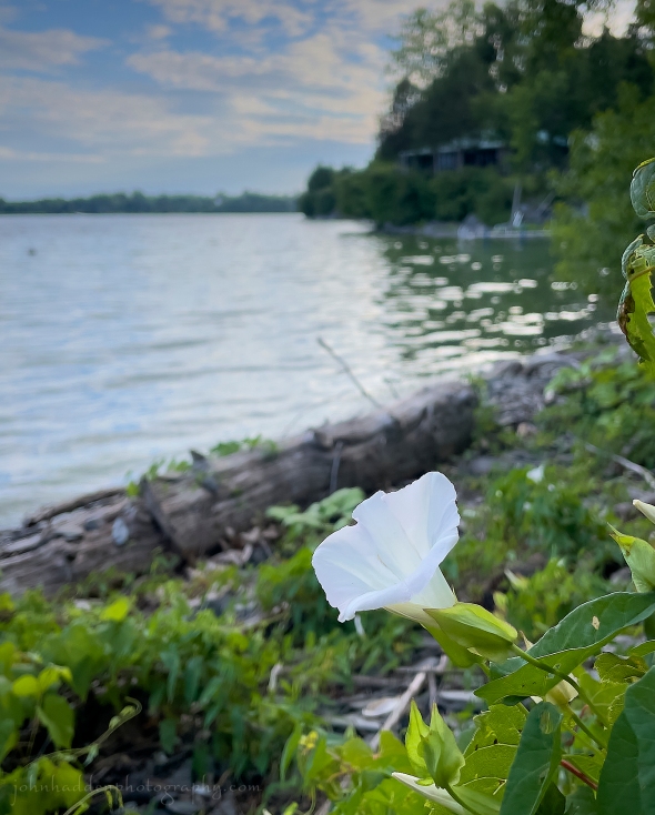 Morning glory blooming on the beach
Morning Observation:
This morning in North Hero at 7:20AM it’s currently 68 degrees and sprinkling lightly under overcast skies. Winds are out of the south at 7-9 mph. Relative humidity is 93%, dewpoint 66, barometric pressure 29.84”. Yesterday’s high was 77, and yesterday’s low was 65. The overnight low got down to 68.
This morning in Huntington it’s currently 65 degrees under overcast skies. Winds are calm. Relative humidity is 97%, dewpoint 64, barometric pressure 29.86”. We picked up 0.28” of rain yesterday and 0.18” so far today. Yesterday’s high was 76, and yesterday’s low was 57. The overnight low got down to 64.
Forecast Discussion:
Morning radar imagery shows a trough of low pressure over about Kingston, Ontario at this hour. The trough is expected to slowly slide northward during the day today bringing scattered showers to the region during the day. Highs today will be in the mid to upper 70s. Showers are expected to wind down this evening with mostly dry conditions expected for Thursday as a ridge of high pressure moves through. Low pressure passing well to our north will drag a potent cold front across the region late Thursday night into Friday bringing widespread rain and some potentially strong thunderstorms as the front swings through. Some widely scattered showers may linger into Saturday morning before dry and seasonable air makes its way into the region bringing dry and seasonably warm conditions for the remainder of the weekend and into early next week.
3-Day Forecast:
We’ll see mostly cloudy skies today with a 60% chance of showers and afternoon thunderstorms. Highs will be near 77 with south winds 5-8 mph. Rainfall amounts between 0.10″-0.25″ are possible with higher amounts possible in thunderstorms. Tonight should be mostly cloudy with a slight chance of showers before 9:00PM. Lows will be around 64 with southeast winds 5-8 mph.
Thursday should be partly sunny with a high near 80 and south winds 6-9 mph in Huntington and 13-17 mph in the Champlain Valley. Thursday night should be mostly cloudy with a 30% chance of showers. Lows will be around 66 with south winds around 11 mph in Huntington and 17-20 mph in the Champlain Valley. Rainfall amounts between 0.25″-0.50″ are possible.
Friday should be mostly cloudy with showers likely and afternoon thunderstorms. Highs will be near 74 with south winds 10-16 mph becoming southwesterly in the afternoon. Chance of precipitation is 70% with rainfall amounts between 0.50”-0.75” possible. Friday night should be mostly cloudy with a 30% chance of showers. Lows will be around 54 in Huntington and 60 in North Hero with west winds 6-12 mph. Rainfall amounts of less than 0.10″ are possible.
Almanac:
Last year on this date in Huntington we had a high of 82 and a low of 52.
Last year in North Hero we had a high of 84 and a low of 62.
Burlington averages for this date are a low of 61 and a high of 81.
The record low was 43 in 1972.
The record high was 96 in 1944.
The Lake Champlain lake level in Burlington is 98.44′.
The water temperature is 73˚.
Last year’s lake level was at 94.51′.
We had a significant Cyanobacteria bloom yesterday here in North Hero which turned much of our little cove in pea soup. This is the first “close the beach” outbreak that we’ve had here since we bought the place in 2020. Considering the flooding and persistent rainfall this summer, it’s really no surprise…
Sky Notes:
Sunrise: 5:56AM
Sunset: 7:55PM
Length of day: 13:59:32
Today will be 2:43 shorter than yesterday.
The Moon is new, 29 day old with 0% illumination.
Moonrise: 5:49AM
Moonset: 8:32PM
About Today’s Photo:
Morning glories are blooming profusely along the cobbles of the beach right now. This shot captures a bit of our camp in the background.
iPhone 12 Pro
Tuesday, August 15, 2023

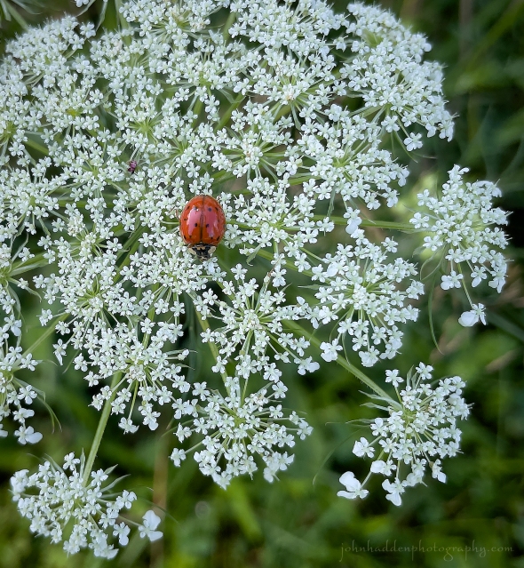 A ladybug on Queen Anne’s lace
Morning Observation:
This morning in North Hero at 6:55AM it’s currently 66 degrees under mostly cloudy skies. Winds are calm. Relative humidity is 95%, dewpoint 64, barometric pressure 29.82”. Yesterday’s high was 76, and yesterday’s low was 65. The overnight low got down to 65.
This morning in Huntington it’s currently 60 degrees under overcast skies. Winds are calm. Relative humidity is 98%, dewpoint 59, barometric pressure 29.84”. Looks like we had a passing sprinkle earlier this morning. Yesterday’s high was 78, and yesterday’s low was 59. The overnight low got down to 57.
Forecast Discussion:
Low pressure currently centered west of New York City has pushed an area of showers into southern New England this morning. Rain should become widespread over southern Vermont this morning, but, with dry air in place north, it’s looking like areas north of the Route 2 corridor should see a mostly dry day today. Showers are expected to taper off this evening, with another round of showers possible over northern sections as a trough lifts through the region overnight. Some lingering showers may persist into Wednesday morning before high pressure builds back in bringing dry and seasonable conditions for Wednesday afternoon through most of Thursday. A more potent storm system is expected to move through the region Thursday night into Friday bringing widespread showers along with seasonably cool temperatures on Friday. At this point, the weekend is looking dry and seasonable.
3-Day Forecast:
We’ll see mostly cloudy skies today with showers likely in Huntington, mainly between 9:00AM and 1:00PM. Highs will be near 74 with light and variable winds. Chance of precipitation is 70% in Huntington and 40% in North Hero with rainfall amounts of less than 0.10″ possible. Tonight should be mostly cloudy with a 30% chance of showers. Lows will be around 63 with southeast winds 5-7 mph.
Wednesday should be mostly cloudy with a 30% chance of morning showers. Highs will be near 75 with south winds 6-9 mph. Wednesday night ab mostly cloudy with a low around 64 and south winds 4-9 mph.
Thursday should be partly sunny with a high near 80 and south winds 8-14 mph. Thursday night should be mostly cloudy with a 50% chance of showers. Lows will be around 65 with southwest winds 7-13 mph. Rainfall amounts between 0.10″-0.25″ are possible.
Almanac:
Last year on this date in Huntington we had a high of 82 and a low of 47.
Last year in North Hero we had a high of 80 and a low of 60.
Burlington averages for this date are a low of 61 and a high of 81.
The record low was 46 in 1950.
The record high was 97 in 1944.
The Lake Champlain lake level in Burlington is 98.48′.
The water temperature is 71˚.
Last year’s lake level was at 94.54′.
Sky Notes:
Sunrise: 5:54AM
Sunset: 7:57PM
Length of day: 14:02:15
Today will be 2:41 shorter than yesterday.
The Moon is a waning crescent, 28.5 days old with 1% illumination.
Moonrise: 4:44AM
Moonset: 8:10PM
About Today’s Photo:
This ladybug beetle was quite conspicuous against the white of Queen Anne’s lace. These mostly carnivorous beetles feed on aphids and other pests and are considered a beneficial species. There are a wide variety of beetles in the Coccinellidae family, however, and some breed profusely and can invade houses, especially in winter. I think most of us have encountered that…
iPhone 12 Pro
Monday, August 14, 2023

 A bumble bee works Joe-Pye weed at Alburgh Dunes
Morning Observation:
This morning in North Hero at 7:15AM it’s currently 68 degrees under partly cloudy skies. Winds are out of the west at 2-4 mph. Relative humidity is 79%, dewpoint 62, barometric pressure 29.89”. Yesterday’s high was 80, and yesterday’s low was 68. The overnight low got down to 65.
This morning in Huntington it’s currently 61 degrees under partly cloudy skies. Winds are calm. Relative humidity is 98%, dewpoint 60, barometric pressure 29.91”. We picked up 0.48” of rain yesterday. Yesterday’s high was 81, and yesterday’s low was 61. The overnight low got down to 59.
Forecast Discussion:
We’ve got a lovely summer day on tap for today courtesy of high pressure cresting over the region. We’ll see highs in the mid to upper 70s with plenty of sunshine and light winds. Clouds will be on the increase overnight out ahead of the next low pressure system arriving from the Great Lakes. This low is expected to devolve as it slides to our south on Tuesday bringing fairly widespread showers on Tuesday, but, since the bulk of the precipitation is expected to remain south of the region, rainfall totals should be fairly light with no flooding concerns. High pressure will build in for Wednesday into Thursday bringing some nice weather through most of Thursday. Another quick-moving trough is expected to move through on Friday bringing some showers. At this point the weekend is looking dry and seasonable.
3-Day Forecast:
We’ll see mostly sunny skies today with a high near 75 and west winds 5-9 mph. Tonight should be mostly cloudy with showers likely towards daybreak. Lows will be around 59 with light and variable winds. Chance of precipitation is 60% with rainfall amounts of less than 0.10″ possible.
Tuesday should be cloudy with showers. Highs will be near 69 with northeast winds 5-7 mph. Chance of precipitation is 80% with rainfall amounts between 0.25″-0.50″ possible. Tuesday night should be mostly cloudy with a 50% chance of showers. Lows will be around 60 with light northeast winds. Rainfall amounts between 0.10″-0.25″ are possible.
Wednesday should be partly sunny with a high near 77 and light west winds. Wednesday night should be partly cloudy with a low around 58 and light south winds.
Almanac:
Last year on this date in Huntington we had a high of 80 and a low of 46.
Last year in North Hero we had a high of 76 and a low of 60.
Burlington averages for this date are a low of 61 and a high of 81.
The record low was 47 in 1041.
The record high was 92 in 2002 (we had a high of 91 in Huntington).
The Lake Champlain lake level in Burlington is 98.50′.
The water temperature is 72˚.
Last year’s lake level was at 94.58′.
Sky Notes:
Sunrise: 5:53AM
Sunset: 7:58PM
Length of day: 14:04:57
Today will be 2:40 shorter than yesterday.
The Moon is a waning crescent, 27.6 days old with 4% illumination.
Moonrise: 3:38AM
Moonset: 7:44PM
About Today’s Photo:
Joe-Pye weed is a native perennial that’s common here in Vermont during the mid to late summer in fields and open lands. According to Wikipedia, the name comes from a Mohican sachem named Schauquethqueat who lived in the mission town of Stockbridge, MA from 1740 to 1785 and who took as his Christian name, Joseph Pye. The plant was used to treat typhus outbreaks and for the treatment of kidney stones and other urinary tract ailments.
iPhone 12 Pro
Sunday, August 13, 2023

 A red eft in the woods in Huntington
Morning Observation:
This morning in North Hero at 7:30AM it’s currently 68 degrees under partly cloudy skies. Winds are out of the south at 10-15 mph. Relative humidity is 90%, dewpoint 66, barometric pressure 29.76”. We picked up 0.05” of rain yesterday. Yesterday’s high was 75, and yesterday’s low was 62.
This morning in Huntington it’s currently 66 degrees under partly cloudy skies. Winds are calm. Relative humidity is 98%, dewpoint 65, barometric pressure 29.80”. We picked up 0.95” of rain yesterday and 0.02” so far today. Yesterday’s high was 80, and yesterday’s low was 52. The overnight low got down to 61.
Forecast Discussion:
After a partly sunny start to the day, a weak shortwave trough is expected to cross the region today bringing chances for scattered showers and thunderstorms mainly this afternoon. Any storms are expected to be less intense than those that moved through yesterday evening and should wind down this evening as daytime heating wanes. High pressure will build in briefly for Monday bringing a dry and a seasonable day. A more organized low pressure system is expected to track eastward out of the Great Lakes on Tuesday bringing widespread showers and afternoon thunderstorms. At this point, Wednesday and Thursday are looking dry and seasonable with another round of showers and thunderstorms expected Friday.
3-Day Forecast:
We’ll see partly sunny skies today with a 40% chance of showers and thunderstorms this afternoon. Highs will be near 79 with south winds 8-14 mph becoming westerly in the afternoon. Rainfall amounts of less than 0.10″ are possible with higher amounts possible in thunderstorms. Tonight should be mostly cloudy with a low around 60 and southwest winds 5-9 mph.
Monday should be partly sunny with a high near 77 and west winds 6-10 mph. Monday might should be mostly cloudy with a 30% chance of showers after 11:00PM. Lows will be around 60 with with north winds 5-7 mph becoming light and variable after midnight. Rainfall amounts of less than 0.10″ are possible.
Tuesday should be cloudy with showers. Highs will be near 72 with southeast winds around 6 mph becoming northeasterly in the morning. Chance of precipitation is 80% with rainfall amounts between 0.10″-0.25″ possible. Tuesday night should be cloudy with showers. Lows will be around 60 with northeast winds 3-5 mph. Chance of precipitation is 80% with rainfall amounts of less than 0.10″ possible.
Almanac:
Last year on this date in Huntington we had a high of 75 and a low of 48.
Last year in North Hero we had a high of 77 and a low of 59.
Burlington averages for this date are a low of 61 and a high of 81.
The record low was 45 in 1992.
The record high was 97 in 1947.
The Lake Champlain lake level in Burlington is 98.52′.
The water temperature is 71˚.
Last year’s lake level was at 94.60′.
I tallied up our July rain totals. We received 12.02″ of rain in Huntington and 7.74″ in North Hero. Not sure if it’s a record for North Hero as we haven’t been here very long, but it’s easily twice as much rain as we’ve normally received in Huntington since I’ve been keeping records (since 1998!). You can check our the “Historical Data” page of my website for more numbers.
Sky Notes:
Sunrise: 5:52AM
Sunset: 8:00PM
Length of day: 14:07:38
Today will be 2:39 shorter than yesterday.
The Moon is a waning crescent, 26.7 days old with 8% illumination.
Moonrise: 2:36AM
Moonset: 7:10PM
About Today’s Photo:
It’s been a banner summer for amphibians this year (I’m beginning to feel a little amphibious myself…) and I came across several red efts on a morning woods run in Huntington the other day. Red efts are eastern newts in their “eft” stage, which is their juvenile stage when they’re wandering the woods in search of insects and worms. This stage last a good 2-3 years before they return to shallow ponds and streams to breed.
Saturday, August 12, 2023

 A pair of echinacea in our camp garden
Morning Observation:
This morning in North Hero at 7:35AM it’s currently 65 degrees under partly cloudy skies. Winds are out of the south at 3-5 mph. Relative humidity is 86%, dewpoint 61, barometric pressure 29.86”. Yesterday’s high was 73, and yesterday’s low was 59. The overnight low got down to 62.
This morning in Huntington it’s currently 58 degrees under partly cloudy skies. Winds are calm. Relative humidity is 98%, dewpoint 57, barometric pressure 29.91”. Yesterday’s high was 76, and yesterday’s low was 55. The overnight low got down to 52.
Forecast Discussion:
Morning sunshine will give way to increasing clouds through the day as a shortwave trough approaches the region from the Great Lakes. Showers and thunderstorms are expected to move into Vermont later this afternoon/evening and continue overnight. Rainfall totals are expected to be light with this system. Widely scattered showers and afternoon thunderstorms will be lurking on Sunday, but with partly sunny skies and seasonable temperatures expected, the day shouldn’t be a washout. High pressure will build in briefly for Monday with another round of showers expected later Monday night into Tuesday. It this point, Wednesday and Thursday are looking dry and seasonable with another round of showers expected Thursday night into Friday.
3-Day Forecast:
We’ll see increasing clouds today with showers likely, mainly after 5:00PM. Highs will be near 79 with south winds 5-10 mph. Chance of precipitation is 60% with rainfall amounts between 0.10″-0.25″ possible. Tonight should be mostly cloudy with showers likely and possibly a thunderstorm. Lows will be around 65 with south winds 10-15 mph. Chance of precipitation is 60% with rainfall amounts between 0.10″-0.25″ with higher amounts possible in thunderstorms.
Sunday should be partly sunny with a 40% chance of showers and thunderstorms. Highs will be near 79 with south winds 8-14 mph. Rainfall amounts of less than 0.10″ are expected with higher amounts possible in thunderstorms. Sunday night should be mostly cloudy with a low around 60 and southwest winds 5-10 mph.
Monday should be partly sunny with a high near 78 and west winds 3-6 mph. Monday night should be mostly cloudy with a 50% chance of showers. Lows will be around 62 with northwest winds 3-5 mph. Rainfall amounts of less than 0.10″ are possible.
Almanac:
Last year on this date in Huntington we had a high of 69 and a low of 48.
Last year in North Hero we had a high of 71 and a low of 58.
Burlington averages for this date are a low of 62 and a high of 81.
The record low was 47 in 2006 (We had a low of 46 in Huntington).
The record high was 93 in 2002 (we had a high of 88 in Huntington).
The Lake Champlain lake level in Burlington is 98.52′.
The water temperature is 71˚.
Last year’s lake level was at 94.62′.
Sky Notes:
Sunrise: 5:51AM
Sunset: 8:01PM
Length of day: 14:10:18
Today will be 2:38 shorter than yesterday.
The Moon is a waning crescent, 26 days old with 14% illumination.
Moonrise: 1:40AM
Moonset: 6:28PM
About Today’s Photo:
A pair of echinacea offer contrasting colors in our garden here in North Hero. I just love how long-lived these blossoms can be.
Sony A7II, Sony 90mm macro lens, ISO 1250, f/13, 1/60″ exposure
Friday, August 11, 2023

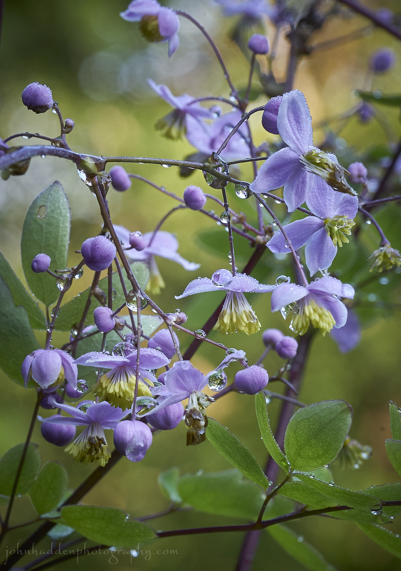 Rain-dappled rue by our front step in Huntington
Morning Observation:
This morning in Huntington at 7:10AM it’s currently 55 degrees under partly cloudy skies. Winds are calm. Relative humidity is 97%, dewpoint 54, barometric pressure 29.62”. We picked up 0.89” of rain yesterday. Yesterday’s high was 83, and yesterday’s low was 59. The overnight low got down to 55.
This morning in North Hero it’s currently 62 degrees under partly cloudy skies. Winds are out of the south at 3-5 mph. Relative humidity is 98%, dewpoint 61, barometric pressure 29.59”. We picked up 1.04” of rain yesterday. Yesterday’s high was 77, and yesterday’s low was 62. The overnight low got down to 59.
Forecast Discussion:
We’ve got a nice late summer day on tap courtesy of high pressure cresting over the region. Outside of a few lingering showers over the NEK this mornign, most of Vermont should remain dry with highs in the mid to upper 70s and plenty of sunshine. Dry conditions will continue into the first part of Saturday before low pressure tracking out of the Great Lakes brings another round of widespread rain Saturday late afternoon/evening into Sunday morning. This is a fairly fast-moving, progressive system, however, so flooding concerns should be minimal. Showers may linger into Sunday before another ridge of high pressure pushes in bringing dry and seasonable conditions later Sunday and into Monday. Thereafter, a forecast models are indicating a fast, progressive airflow regime for next week with showers expected Monday night into Tuesday, high pressure midweek bringing dry and seasonable conditions, and another round of showers at the end of next week.
3-Day Forecast:
We’ll see mostly sunny skies today. Highs will be near 74 with west winds 8-15 mph. Tonight should be partly cloudy with a low around 59 and west winds 5-10 mph.
Saturday should be partly sunny with a 30% chance of afternoon showers and thunderstorms. Highs will be near 78 with south winds 8-13 mph. Rainfall amounts between 0.10″-0.25″ are possible with higher amounts possible in thunderstorms. Saturday night should be mostly cloudy with showers and possibly a thunderstorm. Lows will be around 63 with south winds 7-9 mph in Huntington and 15-17 mph in the Champlain Valley. Chance of precipitation is 70% with rainfall amounts between 0.10″-0.25″ with higher amounts possible in thunderstorms.
Sunday should be partly sunny with a 30% chance of showers. Highs will be near 77 with south winds 9-11 mph becoming westerly in the afternoon. Rainfall amounts of less than 0.10″ are possible. Sunday night should be mostly cloudy with a low around 58 in Huntington and 66 in North Hero with southwest winds 6-8 mph.
Almanac:
Last year on this date in Huntington we had a high of 81 and a low of 56. We picked up 0.63″ of rain.
Last year in North Hero we had a high of 75 and a low of 65. We picked up 0.15″ of rain.
Burlington averages for this date are a low of 62 and a high of 81.
The record low was 46 in 1972.
The record high was 101 in 1944.
The Lake Champlain lake level in Burlington is 98.42′.
The water temperature is 71˚.
Last year’s lake level was at 94.66′.
Sky Notes:
Sunrise: 5:50AM
Sunset: 8:03PM
Length of day: 14:12:56
Today will be 2:36 shorter than yesterday.
The Moon is a waning crescent, 25 days old with 22% illumination.
Moonrise: 12:53AM
Moonset: 5:32PM
About Today’s Photo:
We have a tall, slender rue growing right next to our front step here in Huntington (for some reason, the deer aren’t interested…) It’s in full flower right now with clusters of small, delicate, light purple flowers. Yesterday’s rain and morning dew dapple…
Sony A7II, Sony 90mm macro lens, ISO 1250, f/13, 1/40″ exposure.
Thursday, August 10, 2023

 An eastern giant swallowtail visits the zinnias on our front deck
Morning Observation:
This morning in North Hero at 7:25AM it’s currently 69 degrees under mostly cloudy skies. Winds are out of the south at 8-10 mph. Relative humidity is 85%, dewpoint 64, barometric pressure 29.63”. Yesterday’s high was 80, and yesterday’s low was 63. The overnight low got down to 69.
This morning in Huntington it’s currently 61 degrees under mostly cloudy skies. Winds are calm. Relative humidity is 98%, dewpoint 61, barometric pressure 29.69”. Yesterday’s high was 80, and yesterday’s low was 61. The overnight low got down to 59.
Forecast Discussion:
Clouds will be on the increase this morning out ahead of a pair of shortwave troughs that will swing through later today. We’ll see showers and thunderstorms move into Vermont later this afternoon/evening with showers continuing overnight. This is a quick moving, progressive system so flood risks should be minimal. High pressure will build in for Friday and the first part of Saturday before the next round of showers (seems there’s always a next round this summer…) arrives Saturday night into Sunday as low pressure tracks through the region from the Great Lakes. At this point it’s looking like a fairly progressive upper airflow regime will set up over the continental US for next week bringing intermittent troughs and showers every 48 hours or so interspersed with dry conditions during the week.
3-Day Forecast:
We’ll see increasing clouds today with showers likely and possibly a thunderstorm after 5:00PM. Highs will be near 79 with south winds 6-12 mph. Chance of precipitation is 60% with rainfall amounts between 0.25″-0.50″ with higher amounts possible in thunderstorms. Tonight should be cloudy with showers and possibly a thunderstorm before midnight. Lows will be around 58 with southeast winds 6-8 mph becoming westerly after midnight. Chance of precipitation is 80% with rainfall amounts between 0.25″-0.50″ possible.
Friday should be partly sunny with a 30% chance of showers and thunderstorms. Highs will be near 73 with west winds 8-16 mph. Friday night should be partly cloudy with a low around 54 in Huntington and 62 in North Hero with southwest winds 5-10 mph.
Saturday should be partly sunny with a 30% chance of afternoon showers. Highs will be near 79 with south winds 5-10 mph. Rainfall amounts between 0.10″-0.25″ are possible. Saturday night should be mostly cloudy with showers likely. Lows will be around 61 with south winds 7-14 mph. Chance of precipitation is 70% with rainfall amounts between 0.25″-0.50″ possible.
Almanac:
Last year on this date in Huntington we had a high of 76 and a low of 60.
Last year in North Hero we had a high of 74 and a low of 62.
Burlington averages for this date are a low of 62 and a high of 82.
The record low was 47 in 1964.
The record high was 97 in 1949.
The Lake Champlain lake level in Burlington is 98.39′.
The water temperature is 71˚.
Last year’s lake level was at 94.70′
Sky Notes:
Sunrise: 5:49AM
Sunset: 8:04PM
Length of day: 14:15:32
Today will be 2:35 shorter than yesterday.
The Moon is a waning crescent, 24 days old with 31% illumination.
Moonrise: 12:13AM
Moonset: 4:35PM
About Today’s Photo:
This giant eastern swallowtail came fluttering by as I was reading on our front deck here in North Hero. It was a bit cagey and didn’t really want to sit quietly for its portrait…
Sony A7II, Sony 24-240mm lens @ 240mm, ISO 800, f/8, 1/1600″ exposure
NOTE: you may be getting 2 blog posts today as I discovered this morning when I opened up my laptop that yesterday’s post failed to post. Good ole WordPress…
Wednesday, August 9, 2023

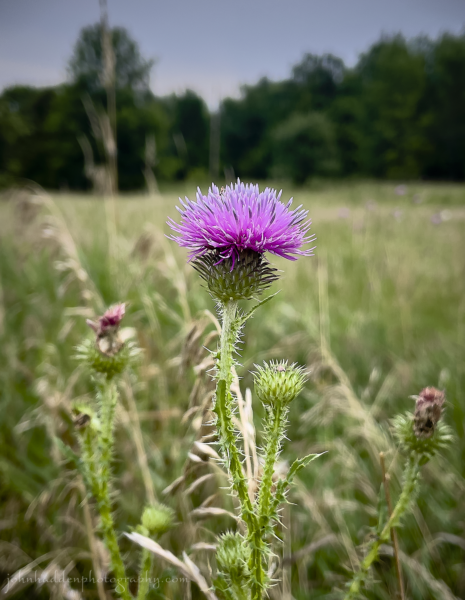 Broad-winged thistle blooming at Pelots Nature Area
Morning Observation:
This morning in North Hero at 7:20AM it’s currently 68 degrees under partly cloudy skies. Winds are calm. Relative humidity is 85%, dewpoint 64, barometric pressure 29.61”. We picked up 1.31” of rain yesterday. Yesterday’s high was 74, and yesterday’s low was 67. The overnight low got down to 63.
This morning in Huntington it’s currently 62 degrees under partly cloudy skies. Winds are calm. Relative humidity is 97%, dewpoint 61, barometric pressure 29.63”. We picked up 2.32” of rain yesterday(!!) Yesterday’s high was 78, and yesterday’s low was 67. The overnight low got down to 62.
Forecast Discussion:
The low pressure system that brought us another copious shot of rain over the past 36 hours is tracking into the Canadian Maritimes this morning. High pressure will build in today bringing partly cloudy skies, highs in the mid to upper 70s, and refreshing northwest winds. Thursday is looking mostly dry, however, two shortwave troughs—one tracking to our north and one to our south—will bring another round of showers and thunderstorms starting later Thursday afternoon/evening and overnight. This is a fast-moving system, however, so showers are expected to clear the region by Friday morning. An active but relatively dry weekend is expected with a slight chance of afternoon showers Saturday, increasing overnight, with some more showers possible on Sunday. Not a washout by any means though.
3-Day Forecast:
We’ll see partly sunny skies today with a high near 78 and northwest winds 10-15 mph. Tonight should be partly cloudy with a low around 59 in Huntington and 65 in North Hero with west winds 6-12 mph becoming southerly after midnight.
Thursday should bring increasing clouds with a 60% chance of showers and thunderstorms. Highs will be near 80 with south winds 7-11 mph in Huntington and 14-20 mph in the Champlain Valley. Chance of precipitation is 60% with rainfall amounts between 0.10″-0.25″ except higher amounts possible in thunderstorms. Thursday night should be mostly cloudy with showers. Lows will be around 60 and southeast wind around 6 mph. Chance of precipitation is 80% with rainfall amounts between 0.50”-0.75” possible.
Friday should be partly sunny with a 30% chance of morning showers. Highs will be near 74 with west winds 8-15 mph. Friday night should be partly cloudy with a low around 55 in Huntington and 63 in North Hero with west winds 5-10 mph becoming southerly overnight.
Almanac:
Last year on this date in Huntington we had a high of 74 and a low of 61. We picked up 0.22″ of rain.
Last year in North Hero we had a high of 69 and a low of 60. We picked up 0.16″ of rain.
Burlington averages for this date are a low of 62 and a high of 82.
The record low was 46 in 1960.
The record high was 99 in 2001 (we had a high of 91 in Huntington).
The Lake Champlain lake level in Burlington is 98.24′.
The water temperature is 71˚.
Last year’s lake level was at 94.72′.
Sky Notes:
Sunrise: 5:48AM
Sunset: 8:06PM
Length of day: 14:18:08
Today will be 2:33 shorter than yesterday.
The Moon is a waning crescent, 23 days old with 41% illumination.
No Moonrise
Moonset: 3:27PM
About Today’s Photo:
Another candidate in the “gets a bum rap” category, broad-winged thistle is often maligned as an invasive species. It’s native to France and was introduced into North America. In some parts of the US it is considered invasive, but here in Vermont, I find it rather pretty!
iPhone 12 Pro
Tuesday, August 8, 2023

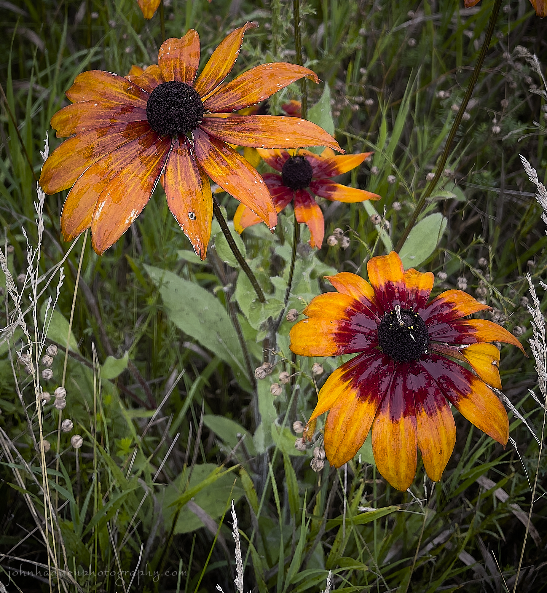
Deep orange-red black-eyed Susans at Pelots Nature Area
Morning Observation:
This morning in North Hero at 6:50AM it’s currently 71 degrees and raining under overcast skies. Winds are out of the south at 16-20 mph. Relative humidity is 93%, dewpoint 69, barometric pressure 29.53”. We picked up 0.55” of rain so far today. Yesterday’s high was 72, and yesterday’s low was 66. The overnight low got down to 68.
This morning in Huntington it’s currently 68 degrees under overcast skies. Winds are calm. Relative humidity is 96%, dewpoint 67, barometric pressure 29.59”. We picked up 0.10” of rain yesterday and 1.12” so far today. Yesterday’s high was 70, and yesterday’s low was 56. The overnight low got down to 67.
A Flood Watch remains in effect for most of Vermont (except the Champlain Islands) until noon Wednesday.
Forecast Discussion:
Morning radar imagery shows the center of low pressure over about Toronto at this hour with a deep plume of moisture lifting northward out of the St. Lawrence valley. Showers are expected to wind down later this morning across most of Vermont as a well-defined dry slot works its way into the region. Showers and thunderstorms are expected to redevelop this afternoon as daytime heating takes effect. Some storms may produce heavy rains but are expected to move through quickly without a lot of training occurring. Showers and thunderstorms should wind down overnight with mostly dry conditions expected Wednesday and most of Thursday as high pressure builds in briefly. Showers and thunderstorms are expected to return later Thursday afternoon and linger into Friday morning as low pressure tracks to our north dragging a shortwave trough across the region. Any storms are expected to be fairly mild “garden variety” storms with not a whole lot of rain expected. At this point Friday and Saturday are looking dry and seasonable with another chance of showers arriving Saturday night into Sunday.
3-Day Forecast:
We’ll see mostly cloudy skies today with showers likely, with thunderstorms possible this afternoon. Some of the storms could produce heavy rain. Highs will be near 76 with south winds 8-18 mph. Chance of precipitation is 60% with rainfall amounts between 0.25″-0.50″ possible. Tonight should be cloudy with showers likely and possibly a thunderstorm. Lows will be around 59 in Huntington ad 64 in North Hero with northwest winds 6-8 mph in Huntington and 14-17 mph in the Champlain Valley. Chance of precipitation is 60% with rainfall amounts between 0.10″-0.25″ with higher amounts possible in thunderstorms.
Wednesday should be partly sunny with a high near 78 and northwest winds 9-13 mph in Huntington and 15-17 mph in the Champlain Valley. Wednesday night should be partly cloudy with a low around 60 and northwest wind 5-10 mph.
Thursday should bring increasing clouds with showers likely in the afternoon. Highs will be near 78 with south winds 7-12 mph. Chance of precipitation is 60% with rainfall amounts between 0.10″-0.25″ possible. Thursday night should be cloudy with showers likely and possibly a thunderstorm before 8:00PM. Lows will be around 59 with south winds 5-7 becoming light and variable. Chance of precipitation is 60% with rainfall amounts between 0.10″-0.25″ with higher amounts possible in thunderstorms.
Almanac:
Last year on this date in Huntington we had a high of 90 and a low of 70. We picked up 0.28″ of rain.
Last year in North Hero we had a high of 75 and a low of 64. We picked up 0.17″ of rain. (That’s quite a difference in highs between Huntington and North Hero!)
Burlington averages for this date are a low of 63 and a high of 83.
My source for record highs/lows is temporarily (I hope…) down for the morning…
The Lake Champlain lake level in Burlington is 98.14′.
The water temperature is 71˚.
Last year’s lake level was at 94.71′.
Sky Notes:
Sunrise: 5:46AM
Sunset: 8:07PM
Length of day: 14:20:41
Today will be 2:32 shorter than yesterday.
The Moon is in its last quarter, 22 days old with 51% illumination.
Moonrise: 11:42PM
Moonset: 2:15PM
About Today’s Photo:
This small clump of deep orange-red black-eyed Susans caught my eye yesterday morning after a damp run at Pelots Nature Area here in North Hero. These native plants are lovely butterfly attractants, and the Ojibway peoples used the roots as a poultice for snake bites and to make an infusion for treating colds and worms in children.
iPhone 12 Pro
Monday, August 7, 2023


Brilliant “mare’s tails” over North Hero last evening
Morning Observation:
This morning in North Hero at 6:45AM it’s currently 68 degrees under overcast skies. Winds are out of the south at 4-5 mph. Relative humidity is 73%, dewpoint 59, barometric pressure 29.88”. Yesterday’s high was 79, and yesterday’s low was 65. The overnight low got down to 66.
This morning in Huntington it’s currently 56 degrees under overcast skies. Winds are calm. Relative humidity is 97%, dewpoint 57, barometric pressure 29.91”. Yesterday’s high was 80, and yesterday’s low was 51. The overnight low got down to 56.
Forecast Discussion:
We’ve got an active stretch of weather ahead of us for the next 36 hours as low pressure approaches from the Great Lakes. The low will lift a warm front through the region today bringing widespread showers and afternoon thunderstorms to the region. Showers and thunderstorms will intensify overnight and into Tuesday as the low is expected to move directly over the region during the day on Tuesday brining widespread, heavy rain and thunderstorms. Some storms my “train” once again dropping in excess of 1.5″-2″ of rain some areas. Flash flooding will be a concern overnight tonight and through the day on Tuesday, but at this point, the NWS hasn’t raised any watches. Showers and thunderstorms are expected to wind down later on Tuesday evening/night as the low pulls away from the region. Some showers may linger into Wednesday morning , but high pressure is expected to build in for midweek with pleasant and mostly dry conditions expected Wednesday and Thursday. The next chance of showers arrives Thursday night.
3-Day Forecast:
We’ll see cloudy skies today with showers likely and afternoon thunderstorms. Highs will be near 71 with southeast winds 6-11 mph. Chance of precipitation is 70% with rainfall amounts of less than 0.10″ with higher amounts possible in thunderstorms. Tonight should be cloudy with a 60% chance of showers and thunderstorms. Some of the storms could produce heavy rainfall. Lows will be around 64 with south winds 11-18 mph. Rainfall amounts between 0.50”-0.75” are possible.
Tuesday should be cloudy with showers and thunderstorms. Some of the storms could produce heavy rainfall. Highs will be near 75 with south winds 13-18 mph. Chance of precipitation is 70% with rainfall amounts between 0.50”-0.75” possible. Tuesday night should be cloudy with showers likely. The rain could be heavy at times. Lows will be around 60 with west winds 8-15 mph. Chance of precipitation is 80% with rainfall amounts between 0.25″-0.50″ possible.
Wednesday should start out cloudy with showers before 8:00AM. Skies should become partly sunny with a high near 77 and northwest winds 9-15 mph. Chance of precipitation is 50% with rainfall amounts of less than 0.10″ possible. Wednesday night should be partly cloudy with a low around 58 in Huntington and 65 in North Hero with southwest winds around 7 mph.
Almanac:
Last year on this date in Huntington we had a high of 91 and a low of 69.
Last year in North Hero we had a high of 88 and a low of 75.
Burlington averages for this date are a low of 62 and a high of 82.
The record low was 40 in 1964.
The record high was 95 in 2001 (we had a high of 89 in Huntington).
The Lake Champlain lake level in Burlington is 98.13′.
The water temperature is 71˚.
Last year’s lake level was at 94.73′.
Sky Notes:
Sunrise: 5:45AM
Sunset: 8:09PM
Length of day: 14:23:13
Today will be 2:30 shorter than yesterday.
The Moon is waning gibbous, 21 days old with 62% illumination.
Moonrise: 11:16PM
Moonset: 1:00PM
About Today’s Photo:
We went for an after-dinner paddle yesterday evening and caught some brilliant “mare’s tail” clouds stretching over North Hero. There really isn’t a wide-angle lens that could do the scene justice! As a teenager I did a lot of summer canoe tripping in northern Ontario and Québec, and learned that mare’s tails—high altitude cirrus clouds blown on jetstream winds—were an indication of changing weather in the next 12 hours or so. Sure enough, we’ll be in for a change today after a lovely weekend stretch of summer weather.
iPhone 12 Pro
