Sunday, March 31, 2019


Fun costumes at the Mardi Gras Procession in Burlington yesterday
Morning Observation:
This morning in Huntington at 7:05AM it’s currently a balmy 54 degrees under partly cloudy skies. Winds are calm. Relative humidity is 66%, dewpoint 43, barometric pressure 29.52” and falling slowly. We have 9” of snow at the stake though our front field is bare. Yesterday’s high was 59, and the overnight low was 51.
Forecast:
Low pressure moving out of the Great Lakes this morning will drag a slow moving cold front across the region today bringing periods of rain. Morning radar imagery shows a thick band of showers currently edging into the western ‘Dacks. Rainfall should reach the Champlain Valley by 1:00PM this afternoon. Temperatures will start out quite warm today with readings in the 50s to near 60 across Vermont and parts of Northern New York, but fall into the 30s and 40s by this afternoon as the cold front swings through. Rain showers will transition to snow showers across the ‘Dacks by midday and the Greens by later this afternoon. Elevations above 1000’ may see some minor accumulations by Monday morning in the range of 1″-3″ with the highest amounts over the summits. Cool high pressure will build in for Monday, and temperatures will moderate by midweek to seasonable levels.
This morning’s sunshine will give way to clouds by midday and rain by 2:00pm. Temperatures will top out in the mid 50s and fall to around 38 by 3:00pm. Winds will be out of the south at 8 to 16 mph becoming northwesterly in the afternoon. Chance of precipitation is 100% with rainfall amounts between 1/4″ to 1/2″ possible. Tonight should be cloudy with a 60% chance of rain and snow showers before 9:00pm, then snow showers late. Lows will be around 23 with northwest winds around 11 mph gusting to 21 mph. New snow accumulation of less than 1/2″ is expected locally.
Monday should be partly sunny with a 20% chance of snow showers before 9:00am. Highs will be near 35 with northwest winds 13 to 15 mph gusting to 25 mph. Monday night should be mostly clear with a low around 23 and west winds 5 to 7 mph becoming southerly after midnight.
Tuesday’s looking mostly sunny with a high near 49 and south winds 7 to 15 mph.
Tuesday night should be mostly cloudy with a low around 31 and south winds 7 to 11 mph.
Almanac:
Last year on this date we had a high of 50 and a low of 22. We picked up 0.19″ of rain and had 7″ of snow at the stake.
Burlington averages for this date are a low of 29 and high of 47.
The record low was 2 in 1954.
The record high was 84 in 1998.
Sky Notes:
Sunrise: 6:35AM
Sunset: 7:17PM
Length of day: 12:42:19
Today will be 3:03 longer than yesterday.
The Moon is a waning crescent, 24 days old with 22% illumination.
Moonrise: 4:45AM
Moonset: 2:40PM
About Today’s Photo:
We went into the big city yesterday to partake of the Magic Hat Mardi Gras festivities on Church Street. Though the parade of past years was significantly scaled down to just a “Procession”, there were fun costumes, a marching band, and plenty of good energy. Street performers and a marionette tent rounded out the activities during the day.
iPhone Xr
Saturday, March 30, 2019
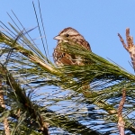
A song sparrow pauses in its singing
Morning Observation:
This morning in Huntington at 7:00AM it’s currently 33 degrees under overcast skies. Winds are calm. Relative humidity is 94%, dewpoint 31, barometric pressure 30.08” and falling. We picked up just a trace of rain in the past 24hrs and have 12” of snow at the stake. Yesterday’s high was 49, and the overnight low was 27.
Forecast:
The frontal system that’s been wobbling north and south over the region for the past couple of days will lift northward as a warm front today bringing rain and warm air into the region. Low pressure approaching from the Great Lakes will track to our north dumping the bulk of its rainfall over northern New York and west of the Saint Lawrence Valley today. The low will drag a cold front through the North Country Sunday bringing additional rainfall, transitioning to higher elevation snowfall Sunday evening into Monday morning. High pressure will build in Monday bringing dry and seasonably cool conditions for the beginning of the work week. Temperatures should moderate again by midweek.
We’ll see cloudy skies today with a 40% chance of rain, mainly before 1:00pm. Highs will be near 54 with southeast winds 6 to 16 mph. Rainfall amounts of of less than 1/10″ are expected. Tonight should be cloudy with a 30% chance of rain. Lows will be around 45 with south winds around 16 mph. Rainfall amounts of of less than 1/10″ are expected.
Sunday should be cloudy with rain likely, mainly before 3:00pm. Highs will be near 51 with south winds 8 to 11 mph becoming northwesterly in the afternoon. Chance of precipitation is 100% with rainfall amounts between 1/4″ and 1/2″ expected. Sunday night should be cloudy with a 50% chance of rain and snow showers before 9:00pm, then a chance of snow showers late. Lows will be around 23 with northwest winds around 10 mph gusting to 20 mph. New snow accumulations of less than 1/2″ are possible.
Monday’s looking mostly sunny with a high near 36 and northwest winds around 11 mph gusting to 26 mph. Monday night should be mostly clear with a low around 22 and light and variable winds.
Almanac:
Last year on this date we had a high of 43 and a low of 43. We picked up 0.61″ of rain and had 8″ of snow at the stake.
Burlington averages for this date are a low of 28 and a high of 46.
The record low was 8 in 1954.
The record high was 80 in 1998.
Sky Notes:
Sunrise: 6:37AM
Sunset: 7:16PM
Length of day: 12:39:15
Today will be 3:03 longer than yesterday.
The Moon is a waning crescent, 24 days old with 30% illumination.
Moonrise: 4:09AM
Moonset: 1:41PM
About Today’s Photo:
Song sparrows are a definite sign of spring in our region. This little fellow’s melodious song caught my ear the other day, so I grabbed my camera and tried to track him down. He was a bit cagey, flying from tree to tree along the edge of our front field, before I could get this relatively decent shot of him in a white pine.
Panasonic GX8, Lumix 100-300mm lens @ 300mm, ISO 800, f/8, 1/1000″ exposure.
Friday, March 29, 2019

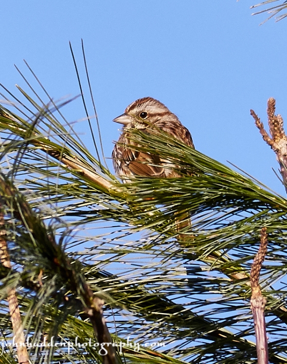
The view west from General Stark Mtn. yesterday midday
Morning Observation:
This morning in Huntington at 6:50AM it’s currently 36 degrees under cloudy skies. Winds are calm. Relative humidity is 88%, dewpoint 33, barometric pressure 29.99” and steady. We picked up 0.01” of rain in the past 24hrs and have 14” of rotting snow at the stake. Yesterday’s high was 49, and the overnight low was 36.
Forecast:
A stationary front is poised to push across the North Country today bringing some light scattered showers. Morning radar imagery shows a line of showers moving along the front over the St. Lawrence valley and heading our way. We should see showers beginning within the next hour. As the name implies, the front will hang out over the region for much of the weekend allowing low pressure lifting northeastward from the Ohio River valley to track along it and eventually across our region on Saturday night. Rounds of light rain showers will move through the region tonight through early Sunday with heaviest rainfall occurring Saturday night into Sunday morning with perhaps 0.50″-1″ in the ‘Dacks and 0.25″-0.50″ here in Vermont. If the front wiggles a bit farther south, we may see more rain here. Sunday night rain will change over to light snow showers as the stationary front finally moves eastward and a cold front moves through. Little or now snow accumulation is expected. After a cool start to the work week, mild conditions are expected by midweek.
We’ll see cloudy skies today with a 50% chance of showers, mainly before 1:00pm. Highs will be near 49 with south wind 5 to 7 mph becoming westerly in the afternoon. Rainfall amounts of less than 1/10″ are expected. Tonight should be cloudy wit a 40% chance of showers. Lows will be around 32 with north winds around 5 mph becoming light and variable.
Saturday should be cloudy with rain likely. Highs will be near 55 with south winds 7 to 14 mph. Chance of precipitation is 60%. Saturday night will be cloudy with showers likely. Lows will be around 38 with south winds 13 to 15 mph. Chance of precipitation is 80% with rainfall amounts between 1/10″ and 1/4″ expected.
Sunday should be cloudy with showers likely, mainly before 11:00am. Highs will be near 45 with southwest winds 9 to 11 mph becoming northwesterly in the morning. Chance of precipitation is 80% with rainfall amounts between 1/4″ and 12″ expected. Sunday night should be mostly cloudy with a low around 23 and northwest winds around 7 mph.
Almanac:
Last year on this date we had a high of 53 and a low of 34. We picked up 0.22″ of rain and had 11″ of snow at the stake.
Burlington averages for this date are a low of 28 and a high of 46.
The record low was 0 in 1974.
The record high was 84 in 1946.
Sky Notes:
Sunrise: 6:39AM
Sunset: 7:15PM
Length of day: 12:36:11
Today will be 3:04 longer than yesterday.
The Moon is a waning crescent, 23 days old with 39% illumination.
Moonrise: 3:27AM
Moonset: 12:45PM
About Today’s Photo:
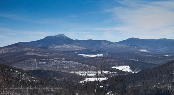
Yesterday morning started out nice and sunny and was a great morning to hit the slopes of Mad River Glen. As the day wore on, clouds began to move in from the west, and this westerly view from the summit of General Stark Mountain shows a brooding sky over the High Peaks of the ‘Dacks and the Champlain Valley.
Panasonic GX8, Lumix 14-140mm lens @ 19mm, ISO 800, f/16, 1/320″ exposure.
Thursday, March 28, 2019
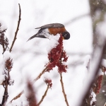

A robin munches on sumac during the recent snow
Morning Observation:
This morning in Huntington at 7:50AM it’s currently a balmy 36 degrees under mostly sunny skies. Winds are calm. Relative humidity is 49%, dewpoint 18, barometric pressure 30.28” and falling slowly. We have 17” of snow at the stake. Yesterday’s high was 46, and the overnight low was 28.
Forecast:
The high pressure that has been delivering our dry and sunny conditions is moving east of the region this morning. We’ll see temperatures bump into the 50s today with increasing clouds and a gusty south wind. There will be a chance for showers later in the day north as a weak cold front crosses the area overnight. The front will stall to our south and then wobble north and south allowing for several waves of low pressure to track along it bringing off and on periods of rain this weekend. Temperatures will remain warm through Sunday before a strong cold front moves through Sunday night allowing any lingering rain showers to transition to snow. High pressure is set to move in on Monday for a cool start to the work week.
We’ll see sunny skies this morning giving way to increasing clouds. Highs will be near 52 with breezy south winds at 16 to 22 mph. Tonight should be cloudy with a 50% chance of showers, mainly after 9:00pm. Lows will be around 39 with south winds 10 to 15 mph. Rainfall amounts of less than 1/10″ are expected.
Friday should be mostly cloudy with 20% chance of showers before noon. Highs will be near 49 with south winds 5 to 7 mph becoming light and variable in the morning. Friday night should be cloudy with a 60% chance of showers. Lows will be around 35 with north winds around 5 mph becoming calm. Rainfall amounts of less than 1/10″ are expected.
Saturday should be cloudy with rain likely. Highs will be near 54 with southeast winds around 11 mph. Chance of precipitation is 80% with rainfall amounts between 1/10″ and 1/4″ expected. Saturday night should be cloudy with rain likely. Lows will be around 40 with southwest winds 3 to 5 mph. Chance of precipitation is 90% with rainfall amounts between 1/10″ and 1/4″ expected.
Almanac:
Last year on this date we had a high of 49 and a low of 34. We picked up 0.05″ of rain and had 12.5″ of snow at the stake.
Burlington averages for this date are a low of 27 and a high of 45.
The record low was 4 in 1974.
The record high was 79 in 1945.
Sky Notes:
Sunrise: 6:40AM
Sunset: 7:14PM
Length of day: 12:33:07
Today will be 3:04 longer than yesterday.
The Moon is in its last quarter, 22 days old with 48% illumination.
Moonrise: 2:39AM
Moonset: 11:52AM
About Today’s Photo:
Most people associate robins with springtime. If you live down in the Champlain Valley, however, you may see groups of them throughout the winter foraging along the bare sides of roads. These are likely to be Canadian robins who have come south to overwinter in the relatively warmer valley. Our summertime resident robins do indeed head south in the fall and return this time of year. Once you start seeing them in upper elevations like Huntington, it’s a good bet that it’s a returning summer robin. This one is enjoying a nutrient rich meal of sumac at the edge of our woods.
Panasonic GX8, Lumix 100-300mm lens @ 300mm, ISO 1250, f/5.6, 1/1600″ exposure.
Wednesday, March 27, 2019

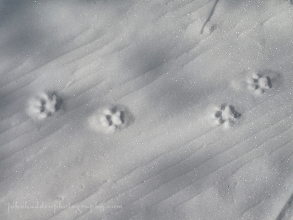
Crow tracks in our front field
Morning Observation:
This morning in Huntington at 7:35AM it’s currently a brisk 11 degrees under clear skies. Winds are calm. Relative humidity is 89%, dewpoint 8, barometric pressure 30.52 and rising slowly. We have 18.5” of snow at the stake. Yesterday’s high was 35, and the overnight low was 10.
Forecast:
High pressure will crest over the region early this morning and then push eastward during the day setting us up for a warming trend to wrap up the week. We’ll see warm and dry conditions today through early Thursday before a weak cold front sags southward bringing chances for light rain Thursday night. The front will stall to our south Friday allowing for weak high pressure to build in bringing partly sunny skies and highs in the 50s Friday. The front will lift northward Saturday as a trough approaches from the Great Lakes along the front bringing more showers into Sunday. The front will finally move to our east late Sunday bringing colder air behind it and a chance for light mountain snow flurries Sunday night. While it may be a dampish weekend, temperatures will bump into the 60s on Saturday and be in the 50s Sunday, so it’ll feel much more springlike.
We’ll see sunny skies today with a high near 44 and calm winds becoming southerly 5 to 7 mph in the afternoon. Tonight should be mostly clear with a low around 29 and south winds 6 to 10 mph.
Thursday should start out mostly sunny with increasing clouds and a 20% chance of showers after 3:00pm. Highs will be near 50 with south winds 11 to 15 mph. Thursday night should be cloudy with a 50% chance of showers. Lows will be around 38 with south winds 13 to 17 mph. Rainfall amounts of less than 1/10″ are expected.
Friday should be partly sunny with a high near 51 and southwest winds 5 to 8 mph becoming northwesterly in the afternoon. Friday night should be cloudy with rain likely after 2:00am. Lows will be around 36 with light and variable winds. Chance of precipitation is 60% with rainfall amounts of less than 1/10″ expected.
Almanac:
Last year on this date we had a high of 48 and a low of 18. We had 14″ of snow at the stake.
Burlington averages for this date are a low of 27 and a high of 45.
The record low was 6 in 2014 (we had a low of 1).
The record high was 71 in 1976.
Sky Notes:
Sunrise: 6:42AM
Sunset: 7:12PM
Length of day: 12:30:03
Today will be 3:04 longer than yesterday.
The Moon is waning gibbous, 21 days old with 58% illumination.
Moonrise: 1:44AM
Moonset: 11:03PM
If any of you happened to be awake this morning between 3:00AM and sunrise, you may have noticed that the moon was accompanied by another bright object. This is Jupiter. They made a very nice pair in the sky this morning.
About Today’s Photo:
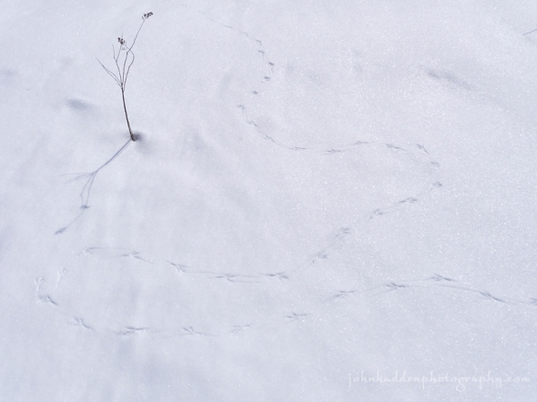
I’ve been noticing several crows hanging around our place over the past couple of days. They check out the compost pile occasionally, but, otherwise, just seem to be wandering around out in the front field. This set of tracks demonstrates a bit of the seemingly aimless meander that one of them took. I could follow the track from where the bird landed, then peregrinated (crowinated?) about for some 20 meters in total before taking wing again.
Panasonic GX8, Lumix 14-140mm lens @ 14mm, ISO 200, f/8, 1/2500″ exposure.
Tuesday, March 26, 2019

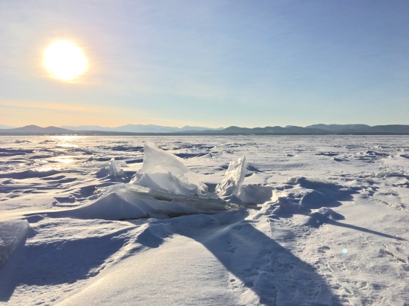
Ice buckles on Lake Champlain
Morning Observation:
This morning in Huntington at 7:05AM it’s currently a brisk 12 degrees under clear skies. Winds are calm. Relative humidity is 84%, dewpoint 8, barometric pressure 30.28” and rising rapidly. We have 19” of snow at the stake. Yesterday’s high was 37, and the overnight low was 11.
Forecast:
We’ve got another lovely, albeit seasonally chilly day on tap today as cold Canadian high pressure continues to build into the region. We’ll see clear skies and temperatures only in the mid 30s—a good 10 degrees below seasonal averages. The high will begin to push east of our region tomorrow setting up a southwesterly airflow that will allow temperatures to recover into the 40s during the day Wednesday. After another cool start Thursday morning, a cold front will sag southward through the our region Thursday afternoon and night bringing a period of light rain showers and allowing temperatures to surge into the mid 50s. The front will stall south of us Friday and then wobble north and south over the next few days allowing for a surface low to track along it Friday night into Saturday. We may see a fair amount of rain this weekend, but, on the plus side, temperatures will be heading towards the 60s by Saturday so we’ve got that to look forward to.
We’ll see sunny skies today with a high near 35 and light and variable winds becoming northerly 5 to 8 mph in the morning. Tonight should be clear with a low around 19 and northwest winds 5 to 7 mph becoming calm in the evening.
Wednesday should be sunny with a high near 44 and calm winds becoming southwesterly 5 to 7 mph in the afternoon. Wednesday night should be mostly clear with a low around 25 and south winds 8 to 11 mph.
Thursday should bring increasing clouds with a 40% chance of showers after 2:00pm. Highs will be near 55 with south winds 14 to 17 mph gusting to 30 mph. Thursday night showers are likely. It’ll be cloudy with a low around 37 and southwest winds 7 to 11 mph gusting to 23 mph. Chance of precipitation is 70% with rainfall amounts of less than 1/10″ expected.
Almanac:
Last year on this date we had a high of 47 and a low of 13. We had 15″ of snow at the stake.
Burlington averages for this date are a low of 26 and a high of 44.
The record low was -4 in 1960.
The record high was 71 in 1945.
Sky Notes:
Sunrise: 6:44AM
Sunset: 7:11PM
Length of day: 12:26:59
Today will be 3:04 longer than yesterday.
The Moon is waning gibbous, 20 days old with 69% illumination.
Moonrise: 12:43AM
Moonset: 10:20AM
About Today’s Photo:
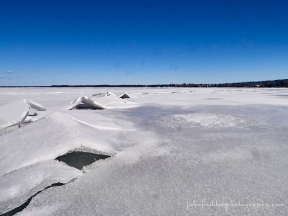
Here’s another shot taken last week when I had the opportunity to venture onto the ice off Oakledge Park in Burlington. These ice buckles were fairly small and thin—about the size of your hands tented together. Below the buckles lay thicker ice. As I walked the ice, I could hear the groaning of the plates and a persistent rumble from out on the broad lake.
Panasonic GX8, Olympus 9-18mm lens @ 9mm, ISO 800, f/16, 1/1000″ exposure.
Monday, March 25, 2019

A fine bluebird view of Camel’s Hump from Butternut cabin at Sleepy Hollow
Morning Observation:
This morning in Huntington at 6:50AM it’s currently 17 degrees under clear skies. Winds are calm. Relative humidity is 82%, dewpoint 12, barometric pressure 30.12” and rising slowly. We picked up 0.50” of new snow overnight and have 19” at the stake. Yesterday’s high was 47, and the overnight low was 17.
Forecast:
Chilly Canadian high pressure has parked itself over the region and will deliver clear skies and below average temperatures through the middle of the week. Daytime highs for the next couple of days will only be in the upper 20s and low 30s with overnight lows in the teens to single digits. As the high moves eastward, we’ll see a noticeable warming trend midweek and into the weekend as highs rise to the 40s on Wednesday and 50s by the end of the week. We can expect dry and quiet conditions for most of the week before rain arrives late Thursday and into the weekend. For those of you into snow sports, this very well may be the last good week to get it…
We’ll see sunny skies today with a high near 34 and west winds 7 to 10 mph. Tonight should be mostly clear with a low around 15 and west winds around 8 mph.
Tuesday should be sunny with a high near 33 and northwest winds around 8 mph. Tuesday night should be clear with a low around 16 and northwest winds around 5 mph becoming calm in the evening.
Wednesday’s looking sunny and milder with a high near 49 and southwest winds 3 to 7 mph. Wednesday night should be mostly clear with a low around 29 and south winds 3 to 6 mph
Almanac:
Last year on this date we had a high of 42 and a low of 14. We had 16.5″ of snow at the stake.
Burlington averages for this date are a low of 26 and a high of 44.
The record low was 0 in 1960.
The record high was 68 in 1996.
Sky Notes:
Sunrise: 6:46AM
Sunset: 7:10PM
Length of day: 12:23:54
Today will be 3:04 longer than yesterday.
The Moon is waning gibbous, 19 days old with 78%, illumination.
No Moonrise
Moonset: 9:41AM
About Today’s Photo:
Yesterday was a lovely bluebird day to be outside. The view eastward from the Butternut cabin at Sleepy Hollow gives a great perspective of the Green Mountain ridgeline from Camel’s Hump southward to Mt. Ira Allen. The three bumps of Bald Hill are clearly visible as is Crow Hill which rises above the Camel’s Hump Nordic trail system.
Panasonic GM5, Lumix 12-32mm lens @ 32mm, ISO 200, f/13, 1/640″ exposure.
Sunday, March 24, 2019
A fresh set of bobcat tracks up at Camel’s Hump Nordic
Morning Observation:
This morning in Huntington at 7:30AM, it’s currently 12 degrees under clear skies. Winds are calm. Relative humidity is 91%, dewpoint 10, barometric pressure 30.05” and steady. We have 21” of snow at the stake. Yesterday’s high was 32, and the overnight low was 11.
Forecast:
We’ve got a lovely day on tap with morning sunshine and temperatures bumping up into the mid 40s by this afternoon. We’ll see increasing clouds through the day, however, as a cold front crosses the region later today into this evening bringing scattered light rain and snow showers, mainly across northern counties. Behind the front, dry and cold conditions will return for Monday and Tuesday as Canadian high pressure builds into the Northeast. As the high slides eastward, southerly winds will usher in much milder air from Wednesday heading into the weekend.
We’ll see sunny skies this morning giving way to increasing clouds this afternoon. Highs will be near 45 with west winds 8 to 10 mph. Tonight should be cloudy with a 50% chance of rain and snow showers before 10:00pm, then a chance of snow showers. Lows will be around 17 with north winds around 6 mph.
Monday should be sunny with a high near 34 and west winds 5 to 8 mph. Monday night should be mostly clear with a low around 12 and northwest winds around 7 mph.
Tuesday’s looking sunny with a high near 32 and northwest winds 5 to 10 mph. Tuesday night should be mostly clear with a low around 14 and northwest winds around 5 mph becoming calm in the evening.
Almanac:
Last year on this date we had a high of 36 and a low of 17. We had 17″ of snow at the stake.
Burlington averages for this date are a low of 25 and a high of 43.
The record low was 1 in 2014 (we had a low of -6).
The record high was 66 in 1979.
Sky Notes:
Sunrise: 6:48AM
Sunset: 7:09PM
Length of day: 12:20:50
Today will be 3:04 longer than yesterday.
The Moon is waning gibbous, 18 days old with 86% illumination.
Moonrise: 11:37PM
Moonset: 9:06PM
About Today’s Photo:
It’s a busy time of year for our cousins who prowl the woods around us. Many species are seeking out mates, marking territory, and just plain prowling. I came across this fine set of bobcat tracks while bushwhacking up in the Camel’s Hump Nordic area the other day. This big kitty was on quite the walk-about as its tracks showed it coving a large amount of territory.
Panasonic GM5, Lumix 12-32mm lens @ 19mm, ISO 400, f/8, 1/2000″ exposure.
Saturday, March 23, 2019

The front yard this morning. 22″ at the stake.
Morning Observation:
Well now, welcome to spring indeed!
This morning in Huntington at 7:25AM it’s currently 23 degrees and snowing lightly under overcast skies. Winds are out of the west at 3-5 mph. Relative humidity is 92%, dewpoint 21. We picked up a whopping 15.4” of new snow in the past 24hrs and have 22” at the stake. Yesterday’s high was 40, and the overnight low was 23.
We were one of the “winners” snowfall-wise with only Caledonia County recording higher storm totals than us. You can read storm totals here.
The Winter Storm Warning remains in effect for our region until noon today.
Forecast:
The nor’easter responsible for our late season dump is pulling off into the Canadian Maritimes this morning. Snow will taper off across region this morning and we should see some breaks of sunshine later today. Mild weather will make a brief return on Sunday before a cold front arrives Sunday night bringing in cold Canadian air under high pressure for the first part of next week. Temperatures will begin to moderate Wednesday night and head towards the 60s by next weekend. Such is Vermont in March!
We’ll see scattered snow this morning before 11:00am diminishing to just a few lingering mountain snow flurries this afternoon. Skies will start out cloudy with sunshine breaking through this afternoon. Highs will be near 32 with northwest winds 14 to 21 mph gusting to 33 mph. Chance of precipitation is 90% with total daytime snow accumulations of 1″ to 2″ possible. Tonight should be clear with a low around 22 and northwest winds 6 to 10 mph becoming southwesterly after midnight.
Sunday should start out clear with increasing clouds. Highs will be near 46 with southwest winds around 8 mph becoming westerly in the afternoon. Sunday night should be cloudy with a 40% chance of rain showers before 9:00pm, then a chance of snow showers after 11:00pm. Lows will be around 23 with north winds 6 to 8 mph.
Monday’s looking mostly sunny with a high near 31 and northwest winds around 10 mph. Monday night should be mostly clear with a low around 12 and northwest winds around 6 mph becoming calm in the evening.
Almanac:
Last year on this date we had a high of 41 and a low of 14. We had 18.5″ of snow at the stake.
Burlington averages for this date are a low of 25 and a high of 43.
The record low was 3 in 2017 (we had a low of -2).
The record high was 68 in 1979.
Sky Notes:
Sunrise: 6:50AM
Sunset: 7:07PM
Length of day: 12:17:45
Today will be 3:04 longer than yesterday.
The Moon is waning gibbous, 17 days old with 93% illumination.
Moonrise: 10:27PM
Moonset: 8:34AM
About Today’s Photo:
I figured a shot of the front yard with snow stake was appropriate for today.
Friday, March 22, 2019

A pair of turkey tracks up at Sleepy Hollow
Morning Observation:
This morning in Huntington at 7:15AM it’s currently 33 degrees and just beginning to snow. Winds are calm. Relative humidity is 95%, dewpoint 32, barometric pressure 29.54” and falling rapidly. We picked up 0.12” of rain overnight and have 7” of snow at the stake. Yesterday’s high was 47, and the overnight low was 33.
There is a Winter Storm Warning in effect for our region until noon on Saturday.
Forecast:
A late season winter storm is on our doorstep this morning as deepening coastal low pressure lifts northeastward through the region today and moves into the Gulf of Maine overnight. Thermal profiles are a bit on the cusp, so snowfall ranges could vary quite a bit, we could see anywhere in the range of 6″-12″ locally with up to 10″-18″ in the northern ‘Dacks and along the spine of the Greens. The storm should taper off quickly Saturday, giving way to partly sunny skies by the afternoon. A mild and sunny day is on tap for Sunday under high pressure. A cold front will sweep through Sunday night bringing some light snow showers and ushering in some chilly Canadian air to start the work week. Temperatures will bounce back to more seasonable levels by midweek.
We’ll see cloudy skies today with rain transitioning to snow. Highs will be near 37 with east winds 6 to 13 mph becoming northerly in the afternoon. Chance of precipitation is 100% with total daytime snow accumulations of 1″-2″ possible. Tonight snow is likely. Lows will be around 24 with blustery northwest winds 14 to 20 mph and gusting to 31 mph. Chance of precipitation is 100% with new snow accumulations of 3″ to 7″ possible.
Saturday should bring snow before 11:00am tapering to lingering snow showers between 11:00am and 2:00pm. Highs will be near 32 with northwest winds around 15 mph. Chance of precipitation is 90% with new snow accumulations of 1″ to 3″ possible. Saturday night should be clear with a low around 22 and southwest winds 6 to 8 mph.
Sunday should start off partly sunny with increasing clouds. Highs will be near 46 with southwest winds around 10 mph. Sunday night should be cloudy with a 40% chance of rain showers before 10:00pm, then a chance of snow showers after midnight. It’ll be mostly cloudy with a low around 23 and northwest winds 3 to 8 mph.
Almanac:
Last year on this date we had a high of 40 and a low of 12. We had 19.5″ of snow at the stake.
Burlington averages for this date are a low of 24 and a high of 42.
The record low was 3 in 1941.
The record high was 81 in 2012 (we had a high of 80).
Sky Notes:
Sunrise: 6:51AM
Sunset: 7:06PM
Length of day: 12:14:40
Today will be 3:04 longer than yesterday.
The Moon is waning gibbous, 16 days old with 97% illumination.
Moonrise: 9:14PM
Moonset: 8:04AM
About Today’s Photo:
I came across this great pair of turkey tracks in fresh snow the other day while skiing at Sleepy Hollow . I can just visualize the pair of big birds strutting along in the snow, one after the other.
iPhone XR
Thursday, March 21, 2019

A view southwest across Lake Champlain from Oakledge Park
Morning Observation:
This morning in Huntington at 7:20AM it’s currently 39 degrees under overcast skies. Winds are out of the south at 0-3 mph. Relative humidity is 63%, dewpoint 28, barometric pressure 30.14” and steady. We have 9” of snow at the stake in our front yard, but our south-facing front field is largely bare. Yesterday’s high was 49, and the overnight low was 30.
There is a Winter Storm Watch in effect for our region from late tonight into Saturday morning.
Forecast:
We’ve got a mild and day on tap today in advance of a late season winter storm which will affect the region tonight into Saturday morning with some wild and wooly weather. Deepening low pressure will lift from the Delmarva Peninsula tonight northeastward along the coast and into the Gulf of Maine and far eastern New England by Saturday. We’ll should see rain arriving by this evening with a bit of snow overnight. Rain will continue into Friday morning before transitioning to wet snow in valleys, and heavy snow in higher elevations by Friday evening. Snowfall amounts are a bit tricky given the temperature profiles, but we may see as little as 3″-4″ in the Champlain Valley, to up to 2 feet of heavy wet snow over the summits of the Greens and ‘Dacks. High pressure will build in behind the departing storm bringing briefly milder weather for Sunday before a strong cold front brings a return to much colder air for next Monday into Wednesday. As the NWS forecaster wrote: welcome to spring in the North Country!
We’ll see cloudy skies today with a 305 chance of light rain this afernoon. High will be near 46 with south winds 7 to 11 mph. Tonight will be cloudy with rain likely before midnight mixing with snow late. Lows will be around 35 with south wind 3 to 7 mph. Chance of precipitation is 80% with little or no snow accumulation expected.
Friday should start out with rain and snow, becoming all rain by noon. Highs will be near 37 with calm winds becoming northwesterly 5 to 8 mph in the afternoon. Chance of precipitation is 100% with little or no snow accumulation expected. Friday night snow is likely. Lows will be around 25 with blustery northwest winds 10 to 20 mph gusting to 32 mph. Chance of precipitation is 100% with new snow accumulations of 2″ to 4″ inches possible.
Saturday should be cloudy with snow likely before 1:00pm, diminishing to snow showers in the afternoon. Highs will be near 32 with a northwest winds 16 to 20 mph and gusting to 33 mph. Chance of precipitation is 80% with new snow accumulations of 1″ to 3″ inches possible. Saturday night should be mostly clear with a low around 21 and northwest winds 5 to 9 mph becoming light after midnight.
Almanac:
Last year on this date we had a high of 34 and a low of 5. We had 20.5″ of snow at the stake.
Burlington averages for this date are a low of 24 and a high of 42.
The record low was -2 in 2007 (we had a low of -5).
The record high was 81 in 2012 (we had a high of 80).
Sky Notes:
Sunrise: 6:53AM
Sunset: 7:05PM
Length of day: 12:11:35
Today will be 3:05 longer than yesterday.
The Moon is waning gibbous, 15 days old with 99% illumination.
Moonrise: 8:00PM
Moonset: 7:35AM
About Today’s Photo:
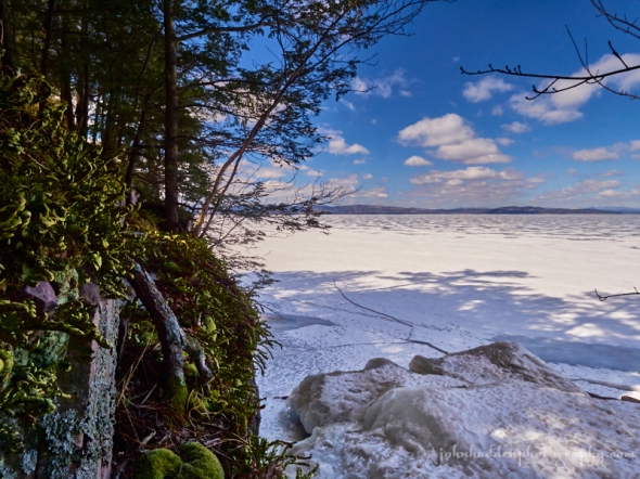
Dried and shriveled rock fern clings to the Monkton quartzite that make up the distinctive red rocks of Oakledge Park (and Red Rocks Park for that matter). The view across the frozen lake to the southwest takes in the High Peaks of the Adirondacks.
Panasonic GX8, Olympus 9-18mm lens @ 10mm, circular polarizing filter, ISO 800, f/16, 1/160″ exposure.
Wednesday, March 20, 2019: The Vernal Equinox

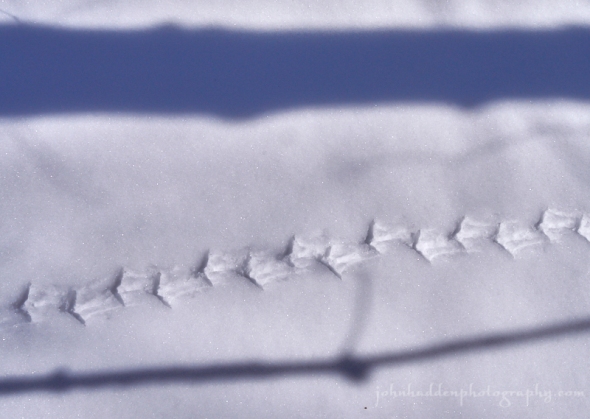
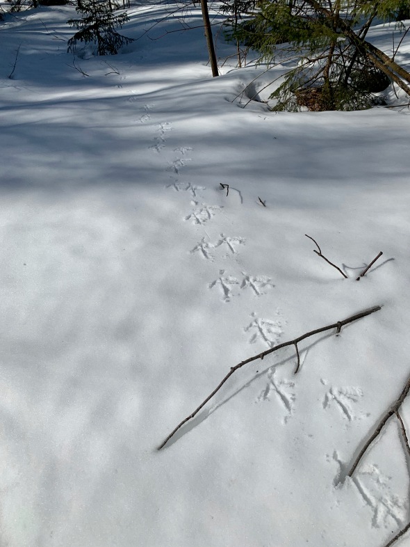
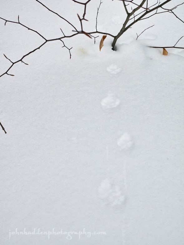
Ruffed grouse tracks in the snow
Happy Spring Equinox!
Morning Observation:
This morning in Huntington at 6:30AM it’s currently 17 degrees under clear skies. Winds are calm. Relative humidity is 91%, dewpoint 15, barometric pressure 30.36” and steady. We have 10” of snow at the stake. Yesterday’s high was 37, and the overnight low was 15.
Forecast:
We’ve got another lovely day on tap with sunny skies and temperatures finally bumping up above normal into the 40s. Our next chance for precipitation arrives on Thursday as an upper level trough approaches from the Great Lakes bringing rain to lower elevations and mountain snow. A strengthening low pressure system will move up the coast Friday bringing widespread valley rain and mountain snows Friday into Saturday. There’s some potential for some more significant wraparound snow Saturday as cold air moves in behind the departing low. Stay tuned…
We’ll see sunny skies today with a high near 47 and southwest winds 5 to 10 mph.
Tonight should bring increasing clouds with a low around 34 and south winds 7 to 13 mph.
Thursday should be cloudy with a 40% chance of rain showers in the afternoon. Highs will be near 46 with south winds 11 to 14 mph. Rainfall amounts of less than 1/10″ are expected. Thursday night should be cloudy with rain, mixing with snow late. Lows will be around 34 with east winds 5 to 9 mph. Chance of precipitation is 90% with new snow accumulations of less 1/2″ expected.
Friday should be cloudy with snow before 7:00am, transitioning to rain after 10:00am. Highs will be near 41 with calm winds becoming northwesterly 5 to 9 mph in the morning. Chance of precipitation is 100% with new snow accumulations of less than 1/2″ expected. Friday night should be cloudy with rain before 9:00pm, transitioning to snow after 11:00pm. Lows will be around 23 with northwest winds 10 to 13 mph gusting to 25 mph. Chance of precipitation is 100% with new precipitation amounts between 1/10″ to 1/4″ expected.
Almanac:
Last year on this date we had a high of 36 and a low of -2.
The record low was -2 in 1949.
The record high was 80 in 2012 (we had a high of 79).
Sky Notes:
Sunrise: 6:55AM
Sunset: 7:04PM
Length of day: 12:08:30
Today will be 3:05 longer than yesterday.
The Moon is the full “Worm” Moon (Northeast Native American).
13.8 days old with 100% illumination.
Moonrise: 6:43PM
Moonset: 7:03AM
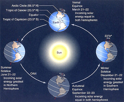
The Vernal Equinox occurs today at 5:58PM. This is the point in the earth’s orbit around the sun when the tilt of earth’s axis is perpendicular to the plane of the sun, allowing for equal amounts of day and night time at the equator. It also marks the astronomical beginning of spring. You can read more about equinoxes here.
Here’s a handy diagram:
About Today’s Photo:
I came across these ruffed grouse (a.k.a. partridge) tracks skiing up at Camel’s Hump Nordic yesterday. A firm crust with a thin layer of powder on top made for perfect tracking conditions. I also saw fox, coyote, and bobcat tracks. It’s a busy time of year!
Panasonic GX8, Lumix 14-140mm lens @ 24mm, ISO 400, f/8, 1/2000″ exposure.
Tuesday, March 19, 2019

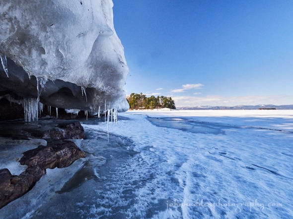
Ice, rock, and sunshine at Oakledge Park
Morning Observation:
This morning in Huntington at 8:30AM it’s currently 20 degrees under clear skies. Winds are calm. Relative humidity is 77%, eep 14, barometric pressure 30.38” and rising slowly. We have 10” of snow at the stake. Yesterday’s high was 36, and the overnight low was 13.
Forecast:
High pressure over the North Country will continue to deliver relatively dry conditions and temperatures slightly below seasonal averages through tonight. An
upper level disturbance moving into the region later today into this evening could bring a few snow showers to the Northern ‘Dacks. South to southwest winds will develop Wednesday bringing above normal temperatures with highs in the 40s. The next chance for precipitation arrives late Wednesday night into Thursday in the form of valley rains and mountain snow showers. Forecast models are struggling with a coastal low the will arrive Friday. Stay tuned…
We’ll see sunny today with a high near 36 and light and variable winds becoming westerly 5 to 8 mph in the morning. Tonight should be partly cloudy with a low around 20 and calm winds becoming southerly around 5 mph after midnight.
Wednesday should be mostly sunny with a high near 47 and southwest winds 7 to 13 mph. Wednesday night should be mostly cloudy with a low around 36 and south winds 8 to 11 mph.
Thursday showers are likely mainly after 1pm. It’ll be cloudy with a high near 47 and south winds 8 to 10 mph. Chance of precipitation is 70% with rainfall amounts between 1/10″-1/4″ expected. Thursday night should be cloudy with a 505 chance of rain showers before midnight, transitioning to snow showers after late. Lows will be around 32 with light south wind.
Almanac:
Last year on this date we had a high of 27 and a low of -6. We had 22.5″ of snow at the stake.
Burlington averages for this date are a low of 23 and a high of 41.
The record low was -10 in 1993.
The record high was 79 in 2012 (we had a high of 77).
Sky Notes:
Sunrise: 6:57AM
Sunset: 7:02PM
Length of day: 12:05:25
Today will be 3:05 longer than yesterday.
The Moon is waxing gibbous, 12.8 days old with 95% illumination.
Moonrise: 5:25PM
Moonset: 6:29AM
About Today’s Photo:
I explored Oakledge Park yesterday morning as I had to be in town for a car appointment. On the bluebird day, it was a treat to wander out onto the ice along the shore capturing images of ice, rock, and sky.
Panasonic GX8, Olympus 9-18mm lens @ 9mm, ISO 800, f/14, 1/80″ exposure.
Monday, March 18, 2019

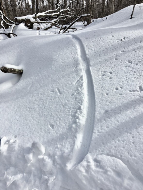
A long-tailed weasel slide up at Sleepy Hollow
Morning Observation:
This morning in Huntington at 7:10AM it’s currently a chilly 10 degrees under clear skies. Winds are calm. Relative humidity is 89%, dewpoint 8, barometric pressure 30.23” and rising slowly. We picked up a 0.1” dusting of snow overnight and have 10.5” at the stake. Yesterday’s high was 32, and the overnight low was 10.
Forecast:
High pressure continues to build down from Canada today bringing dry conditions along with a continuation of below average temperatures. A weak shortwave trough could bring a few snow showers across parts of northern New York this evening, but most of the area will remain dry. Temperatures should begin to moderate back to normal or slightly above normal levels on Wednesday as a shortwave trough moving out of the Great Lakes sets up a southwesterly airflow across the North Country. This system should deliver some precipitation Wednesday night into Thursday with a mixed bag in valley locations and snow in the mountains. There’s not much moisture to work with so accumulation should be limited. Precipitation may linger into Friday before high pressure build back in drying things out.
We’ll see mostly sunny skies today with a high near 32 and calm winds becoming northwesterly 5 to 9 mph in the morning. Tonight should be partly cloudy with a low around 14 and northwest winds around 5 mph becoming calm after midnight.
Tuesday should be mostly sunny with a high near 33 and northwest winds 3 to 8 mph. Tuesday night should be partly cloudy with a low around 21 and light and variable winds becoming southerly around 6 mph in the evening.
Wednesday’s looking partly sunny with a high near 44 and southwest winds 7 to 14 mph. Wednesday night should be mostly cloudy with a 40% chance of rain and snow showers. Lows will be around 34 with south winds 6 to 8 mph. New precipitation amounts of less than 1/10″ are expected.
Almanac:
Last year on this date we had a high of 25 and a low of -10 (brrr!) We had 24.5″ of snow at the stake.
Burlington averages for this date are a low of 23 and a high of 41.
The record low was -7 in 1961.
The record high was 76 in 2012 (…kicking off the 5-day stretch of record breaking heat. We had a high of 77).
Sky Notes:
Sunrise: 6:59AM
Sunset: 7:01PM
Length of day: 12:02:20
Today will be 3:05 longer than yesterday.
You may be curious why today’s length-of-day is more than 12 hours and it’s not the Equinox yet (which occurs on the 20th). For more information about that, click here.
About Today’s Photo:
I came across this distinctive track the other day (before the last thaw) up at Sleepy Hollow. A long-tailed weasel had bounded out of the woods to the edge of the trail and then belly slid down to the trail’s edge. It scampered across the trail and back into the trees. I can’t help but think that it was enjoying itself as it slid!
iPhone 6S
Sunday, March 17, 2019

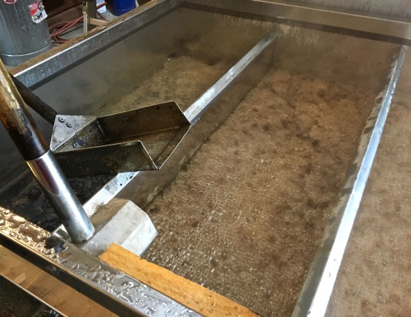
Sugaring down at Sleepy Hollow
Morning Observation:
This morning in Huntington at 7:25AM it’s currently 20 degrees under mostly cloudy skies. Winds are calm. Relative humidity is 65%, dewpoint 10, barometric pressure 30.11” and rising rapidly. We picked up 1.2” of new snow overnight and have 10.5” at the stake. Yesterday’s high was 42, and the overnight low was 19.
Forecast:
Another day, another season. High pressure building into the region will help deliver below average temperatures through Tuesday night. Some scattered snow showers are also possible through Monday morning before things dry out. An increasing
southerly air flow on Wednesday will moderate temperatures back to near or just above normal levels. A trough will move through Wednesday night into Thursday bringing upper elevation snow showers and valley rain. At this point it’s looking like another cool-down Friday.
We’ll see mostly sunny skies today with a high near 29 and west winds 9 to 11 mph. Tonight should be mostly cloudy with a 20% chance of snow showers after 11:00pm. Lows will be around 16 with west winds 6 to 8 mph.
Monday should be mostly sunny with a high near 31 and west winds 5 to 9 mph.
Monday night should be partly cloudy with a low around 12 and northwest winds 3 to 6 mph.
Tuesday’s looking sunny with a high near 32 and calm winds becoming northwesterly around 6 mph in the morning. Tuesday night should be mostly clear with a low around 17 and calm winds.
Almanac:
Last year on this date we had a high of 24 and a low of -5. We had 26″ of snow at the stake.
Burlington averages for this date are a low of 22 and a high of 40.
The record low was -8 in 2014 (we had a low of -11).
The record high was 69 in 1990.
Sky Notes:
Sunrise: 7:01AM
Sunset: 7:00PM
Length of day: 11:59:15
Today will be 3:05 longer than yesterday.
The Moon is waxing gibbous, 10.4 days old with 80% illumination.
Moonrise: 2:51PM
Moonset: 5:06AM
About Today’s Photo:
Sugar makers have been on the job around Huntington over the last couple of days. I stopped by the “Running Saps” operation at Sleepy Hollow to check in on their operations. Dave Enman was minding the arch as the sap boiled down in the pans. The aroma was lovely!
iPhone 6S
Saturday, March 16, 2019

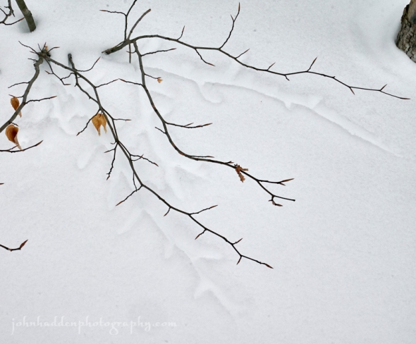
“Branch prints” in the snow
Morning Observation:
This morning in Huntington at 7:55AM it’s currently 37 degrees and snowing lightly under mostly cloudy skies. Winds are out of the west at 3-6 mph. Relative humidity is 83%, dewpoint 32, barometric pressure 29.69” and rising slowly. We picked up 0.02” of rain in the past 24hrs and have 9.5” of snow at the stake. Yesterday’s high was a balmy 60, and the overnight low was 36.
Forecast:
The balmy temperatures that we’ve been enjoying over the last few days are on their way out today as a cold front swings through ushering in another shot of chilly air. We’ll see cooling temperatures today with occasional lingering mountain snow showers, but these will diminish by Sunday, giving way to a dry but seasonably cold temperatures to end the weekend. Below-average temperatures will continue through Tuesday as high pressure delivers mainly dry conditions. Temperatures will start to rise mid-week, along with increasing chances for precipitation heading towards the end of the week.
We’ll see mostly cloudy skies today with a 20% chance of rain and snow showers. High will be near 38 with west winds 14 to 17 mph. Tonight should be cloudy with a 40% chance of snow showers. Lows will be around 18 with west winds around 10 mph. New snow accumulation of less than 1/2″ is expected.
Sunday should be mostly sunny with a high near 30 and west winds around 11 mph. Sunday night should be mostly cloudy with a low around 16 and west winds 3 to 8 mph.
Monday’s looking mostly sunny with a high near 31 and northwest winds 5 to 10 mph. Monday night should be partly cloudy with a low around 13 and northwest winds around 5 mph becoming calm in the evening.
Almanac:
Last year on this date we had a high of 27 and a low of 21. We picked up 4.5″ of new snow and and had 28″ at the stake.
Burlington averages for this date are a low of 22 and a high of 40.
The record low was -9 in 1963.
The record high was 78 in 1990.
Sky Notes:
Sunrise: 7:02AM
Sunset: 6:59PM
Length of day: 11:56:10
Today will be 3:05 longer than yesterday.
The Moon is waxing gibbous, 9.4 days old with 70% illumination.
Moonrise: 1:40PM
Moonset: 4:14AM
About Today’s Photo:
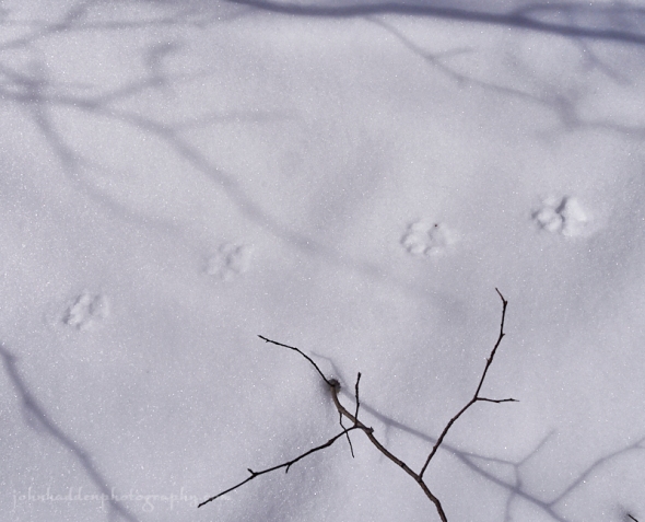
This is an example of one of my favorite early spring phenomena. Branches that had previously been buried beneath the snow are released by the combination of snowpack consolidation and the warm March sun. They leave behind bold “branch prints”, much like 3-D shadows in the snow.
Panasonic GM5, Lumix 12-32mm lens @ 29mm, ISO 400, f/13, 1/1300″ exposure.
Friday, March 15, 2019
Fox prints along the trail at Trapp’s
Morning Observation:
This morning in Huntington at 7:45AM it’s currently 53 degrees and raining lightly under overcast skies. Winds are out of the south at 5-8 mph. Relative humidity is 79%, dewpoint 47, barometric pressure 29.67” and falling slowly. We’ve picked up 0.01″ of rain. Snowpack is down to 13”. Yesterday’s high was 57, and the overnight low was 42.
There is a Flood Watch in effect for our region through Saturday evening.
Forecast:
We’re deep into the thaw this morning. Low pressure moving out of the Great Lakes this morning will continue to push a gusty south to southwesterly airflow through the North Country which will drive valley temperatures into the upper 50s to lower 60s region-wide today. A cold front will swing through this morning bringing light precipitation that will contribute to snowmelt. A Flood Watch is in effect for our region as potential ice breakups could bring ice jams to local streams today into Saturday. A secondary cold front will swing through overnight dropping temperatures and allowing precipitation to change over to snow above 1000′ tonight into Saturday morning, but temperatures should top out around 40 Saturday in valley locations keeping any lingering precipitation there as rain. Temperatures will return to more seasonable mid-March levels for early next week before another warmup heading into next weekend.
We’ll see cloudy skies today with a 50% chance of rain showers, mainly before 3:00pm. Highs will be near 62 with southwest winds 13 to 20 mph gusting to 30 mph. Rainfall amounts of less than 1/10″ are expected. Tonight should be mostly cloudy with a 20% chance of rain showers before 3:00am, then a slight chance of rain and higher elevation snow showers towards daybreak. Lows will be around 33 with west winds 5 to 9 mph.
Saturday should be mostly cloudy with a 30% chance of snow showers, mainly after 8:00am. Highs will be near 39 with west winds 15 to 18 mph gusting to 32 mph. New snow accumulation of less than 1/2″ is expected. Saturday night should be mostly cloudy with a 40% chance of snow showers before 1:00am. Lows will be around 19 with northwest winds 10 to 14 mph. New snow accumulation of less than 1/2″ is expected.
Sunday’s looking mostly sunny with a high near 31 and west winds around 14 mph.
Sunday night should be mostly cloudy with a low around 16 and northwest winds 5 to 7 mph becoming calm after midnight.
Almanac:
Last year on this date we had a high of 34 and a low of 27. We picked up 8″ of new snow and had 27″ at the stake.
Burlington averages for this date are a low of 21 and a high of 39.
The record low was -12 in 1993.
The record high was 72 in 1990.
Sky Notes:
Sunrise: 7:04AM
Sunset: 6:57PM
Length of day: 11:53:05
Today will be 3:04 longer than yesterday.
The Moon is a waxing crescent, 8.3 days old with 56% illumination.
Moonrise: 12:36PM
Moonset: 3:16AM
About Today’s Photo:
As I skied up Chris’s Run at Trapp’s the other day, I noticed a set of fox tracks along the side of the trail. The fox followed the trail for a good kilometer or so, and was light enough to keep from breaking through the thin crust. At one point, it crossed the trail, and I was able to get a nice shot of the tracks. Note the small bit of scent pee next to the beech sapling. Foxes are in breeding mode now, and scent markings are a common sight as males mark their territory and females advertise their fecundity.
Panasonic GM5, Lumix 12-32mm lens @ 23mm, ISO 400, f/8, 1/3200″ exposure.
Thursday, March 14, 2019

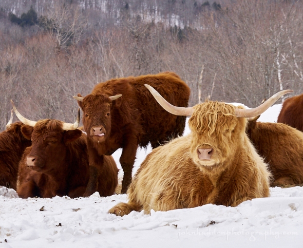
Scotch Highland cows up at Trapp’s
Morning Observation:
This morning in Huntington at 7:30AM it’s currently 33 degrees under overcast skies. Winds are calm. Relative humidity is 97%, dewpoint 32, barometric pressure 30.23” and rising slowly. We picked up 2.5” of fairly heavy snow overnight and have 18” at the stake. Yesterday’s high was 38, and the overnight low was 31.
There is a Flood Watch in effect for our region from Friday morning through Saturday evening.
Forecast:
Our warming trend continues and turns up the heat a few notches today as an increasing south to southwest airflow will bump temperatures into the upper 40s to lower 50s by this afternoon, and well into the 50s on Friday. Low pressure moving out of the Great Lakes will deliver light rains on Friday into Saturday along with gusty winds. Rising river levels and ice jams may result in localized flooding on Friday and Saturday, hence the Flood Watch. Colder air will move in Saturday allowing temperatures to return to more seasonable mid-March levels for early next week when another warmup is expected.
We’ll see mostly cloudy skies today with a high near 52 and southeast winds 7 to 9 mph. Tonight should be mostly cloudy with a 30% chance of showers, mainly after 3:00am. Lows will be around 44 with south winds 14 to 18 mph. Rainfall amounts of less than 1/10″ are expected.
Friday showers are likely. It’ll be mostly cloudy with a high near 58 and south winds 13 to 18 mph gusting to 29 mph. Chance of precipitation is 60% with rainfall amounts between 1/10″-1/4″ expected. Friday night should be cloudy with a 30% chance of showers. Lows will be around 34 with southwest winds 6 to 8 mph.
Saturday should be mostly cloudy with a 30% chance of showers after 5:00pm. Highs will be near 40 with west winds 14 to 17 mph. Saturday night should be mostly cloudy with a 30% chance of rain/snow showers. Lows will be around 19 with northwest winds 8 to 11 mph gusting to 21 mph.
Almanac:
Last year on this date we had a high of 33 and a low of 29. We picked up 11.5″ of new snow and had 21″ at the stake.
Burlington averages for this date are a low of 21 and a high of 39.
The record low was -7 in 1948.
The record high was 67 in 2012 (we had a high of 47?)
Sky Notes:
Sunrise: 7:06AM
Sunset: 6:56PM
Length of day: 11:50:00
Today will be 3:04 longer than yesterday.
The Moon is a waxing crescent, 7 days old with 48% illumination.
Moonrise: 11:42AM
Moonset: 2:12AM
About Today’s Photo:
If you take Trapp Hill Road off the Nebraska Notch Road heading towards Trapp’s in Stowe, you’re likely to see the Scotch Highland cows hanging out in the meadow. These picturesque cows I’m sure are quite used to being photographed by passing tourists, though the road is dirt as it runs by the meadow, so perhaps it keeps some of the flatlanders at bay. The calf here managed to stick its tongue out at me as I took the shot.
Panasonic GX8, Lumix 14-140mm lens @ 109mm, ISO 800, f/13, 1/320″ exposure.
Wednesday, March 13, 2019


Amaryllis blooming in our living room
Morning Observation:
This morning in Huntington at 7:45AM it’s currently 13 degrees under clear skies. Winds are calm. Relative humidity is 90%, dewpoint 11, barometric pressure 30.31” and steady. We have 15” of snow at the stake. Yesterday’s high was 35, and the overnight low was 12.
Forecast:
After a seasonably chilly start to the day, we’re on the cusp of quite a warmup heading our way. High pressure currently over region will shift eastward into the Gulf of Maine this afternoon, ushering in southerly winds that will bump temperatures into the low 40s across the region by this afternoon. A weak upper level trough will bring a brief period of snow tonight, with minor accumulations possible especially over higher terrain. Temperatures will continue to warm Thursday and Friday with persistent south to southwesterly winds. Valley highs will push into the low to mid 50s for Thursday, and the mid to upper 50s Friday. Low pressure moving out of the Great Lakes on Thursday will bring rain showers Thursday night into Friday morning. A trailing cold front will swing through Friday afternoon. Any lingering rain showers should change over to a bit of snow late Friday night into Saturday morning. High pressure is set to build in Saturday into the middle of next week as temperatures return to more seasonable levels.
We’ll see sunny skies this morning with increasing clouds heading towards the afternoon. High will be near 41 with south winds 3 to 8 mph. Tonight rain and snow showers are likely before 10:00pm with a chance of snow showers late. It’ll be cloudy with a low around 30 and south winds around 8 mph. Chance of precipitation is 60% with new snow accumulation of less 1/2″ expected.
Thursday should be mostly cloudy with a high near 52 and south winds 7 to 10 mph gusting 21 mph. Thursday night should be mostly cloudy with a 305 chance of showers after 1:00am. Lows will be around 41 with south winds 11 to 14 mph. Rainfall amounts of less than 1/10″ are expected.
Friday showers are likely, mainly before 3:00pm. It’ll be cloudy with a high near 58 and south winds 14 to 17 mph gusting to 28 mph. Chance of precipitation is 60% with rainfall amounts between 1/10″ and 1/4″ expected. Friday night should be cloudy with a 305 chance of showers. Lows will be around 35 with southwest winds around 5 mph. Rainfall amounts of less than 1/10″ are expected.
Almanac:
Last year on this date we had a high of 34 and a low of 28. We picked up 0.25″ of new snow and had 11″ at the stake.
Burlington averages for this date are a low of 21 and a high of 39.
The record low was -7 in 1948.
The record high was 67 in 2012 (we had a high of 65).
Sky Notes:
Sunrise: 7:08AM
Sunset: 6:55PM
Length of day: 11:46:55
Today will be 3:04 longer than yesterday.
The Moon is a waxing crescent, 6.2 days old with 38% illumination.
Moonrise: 10:57AM
Moonset: 1:07AM
About Today’s Photo:
Something a little different for today. The amaryllis that Robin has been taking care of bloomed the other day (on her birthday no less!) This the second time around for this beautiful plant and it’s put out several lovely white blossoms with more to come. I figured some of you might appreciate a taste of things to come (albeit a ways down the road–we still have mud season to enjoy…)
Panasonic GX8, Olympus 60mm macro lens, IOS 1600, f/13, 1/30″ exposure.
Tuesday, March 12, 2019

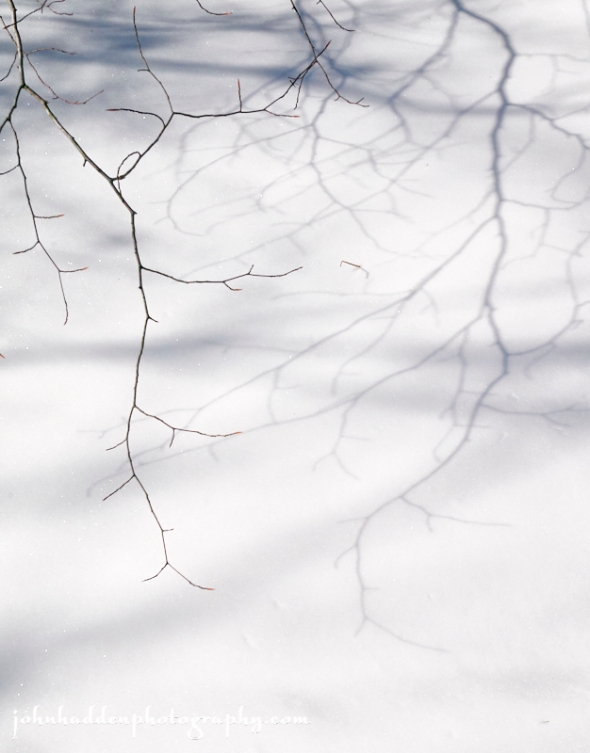
Branches mirrored in the snow
Morning Observation:
This morning in Huntington at 8:30AM it’s currently 25 degrees and snowing lightly under overcast skies. Winds are calm. Relative humidity is 94%, dewpoint 21, barometric pressure 30.10” and rising rapidly. We picked up 0.7” of new snow overnight and have 15.5” at the stake. Yesterday’s high was 39, and the overnight low was 25.
Forecast:
Surface high pressure building eastward from the the Great Lakes this morning will bring dry conditions to the North Country today through Thursday. Temperatures will be a tad below normal today and tonight, but as the high shifts to our east, a south to southwesterly air flow will usher in a considerable warming trend. We’ll see valley highs reach into the lower 40s on Wednesday, the upper 40s to lower 50s on Thursday, and the mid to upper 50s on Friday. An approaching frontal system will bring increasing chances for rain showers late Thursday night into Friday.
We’ll mostly cloudy skies this morning with a 205 chance of snow showers before 9AM. Skies will gradually become sunny with a high near 33 and northwest winds 10 to 13 mph. Tonight should be mostly clear with a low around 17 and northwest winds around 5 mph becoming light and variable in the evening.
Wednesday should bring increasing clouds with a high near 41 and south winds around 6 mph. Wednesday night should be mostly cloudy with a low around 29 and south winds around 7 mph.
Thursday’s looking partly sunny with a high near 51 and south winds 7 to 10 mph.
Thursday night should be mostly cloudy with a 50% chance of rain after 8:00pm. Lows will be around 41 with south winds around 10 mph gusting to 21 mph. Rainfall amounts of less 1/10″ are expected.
Almanac:
Last year on this date we had a high of 38 and a low of 19. We had 12″ of snow at the stake.
Burlington averages for this date are a low of 20 and a high of 38.
The record low was -14 in 1948.
The record high was 63 in 2012 (we had a high of 62).
Sky Notes:
Sunrise: 7:10AM
Sunset: 6:54PM
Length of day: 11:43:50
Today will be 3:04 longer than yesterday.
The Moon is a waxing crescent, 5.3 days old with 28% illumination.
Moonrise: 10:20AM
Moonset: 12:01AM
About Today’s Photo:
On bright, sunny snow-filled days, I find myself captivated by shadows cast across the snow. The snow seems to act almost like a mirror as branches and twigs cast stark shadows in high relief across the pallet of white.
Panasonic GM5, Lumix 12-32mm lens @ 27mm, ISO 400, f/8, 1/5000″ exposure.
Monday, March 11, 2019

Bobcat tracks on the trail at Sleepy Hollow
Morning Observation:
This morning in Huntington at 8:00AM it’s currently 36 degrees under overcast skies. Winds are out of the west at 3-6 mph. Relative humidity is 78%, dewpoint 30, barometric pressure 29.81” and steady. We picked up 0.40” of snow/sleet in the past 24hrs and a trace of rain. We have 15” of snow at the stake. Yesterday’s high was 37 and the overnight low was 35.
Forecast:
We’ll see above normal temperatures through this afternoon before a weak cold front sags southward this evening bringing more seasonable temperatures and a bit of snow to the ‘Dacks and western slopes of the Greens. Gusty southwesterly winds will continue through the day before winds weaken and shift to the northwest tonight. High pressure will build in Tuesday bringing temperatures back to more seasonal levels briefly along with dry conditions. After a seasonably chilly night Tuesday, a warming trend is expected through the rest of the week with temperatures bumping up into the mid 40s Wednesday and Thursday, and the 50s by Friday. Our next chance for precipitation looks to arrive Friday it the form of rain.
We’ll see cloudy skies today with a 30% chance of rain and snow showers. Highs will top out at around 40 with west winds 15 to 20 mph gusting to 32 mph. Little or no snow accumulation expected. Tonight should be cloudy with rain and snow showers likely, becoming all snow after 9:00pm. Lows will be around 22 with northwest winds 13 to 16 mph gusting to 29 mph. Chance of precipitation is 70% with new snow accumulations of 1″ to 2″ possible.
Tuesday should be partly sunny with a high near 31 and northwest winds around 14 mph gusting to 24 mph. Tuesday night should be partly cloudy with a low around 18 and northwest winds around 6 mph becoming light and variable after midnight.
Wednesday’s looking mostly sunny with a high near 42 and south winds 3 to 8 mph.
Wednesday night should be mostly cloudy with a low around 29 and light south winds.
Almanac:
Last year on this date we had a high of 34 and a low of 27. We picked up 3.5″ of new snow and had 13.5″ at the stake.
Burlington averages for this date are a low of 20 and a high of 38.
The record low was -8 in 1961.
The record high was 56 in 1977.
Sky Notes:
Sunrise: 7:12AM
Sunset: 6:52PM
Length of day: 11:40:45
Today will be 3:04 longer than yesterday.
The Moon is a waxing crescent, 4.3 days old with 19% illumination.
Moonrise: 9:48AM
No moonset
About Today’s Photo:
Robin & I were skiing up at Sleepy Hollow the other morning when we came across this set of bobcat tracks on a higher elevation trail. We came across its tracks several times as the cat was busily prowling the hilltop for prey. We saw many other types of tracks that day as well including mice, fox, coyote, and fisher. Hopefully the cat found itself a meal.
Panasonic GM5, Lumix 12-32mm lens @ 22mm, ISO 400, f/8, 1/5000″ exposure.
Sunday, March 10, 2019
Frozen Lake Champlain yesterday afternoon
Morning Observation:
This morning in Huntington at 8:45AM Eastern Daylight Savings Time, it’s currently 28 degrees and snowing under overcast skies. Winds are our of the east at 8-15mph and gusting to 39 mph. Relative humidity is 92%, dewpoint 23, barometric pressure 30.15” and falling rapidly. We’ve picked up maybe 0.2” of new snow (hard to tell with all the wind) and have 14.5” at the stake. Yesterday’s high was 37, and the overnight low was 27.
There is a Wind Advisory in effect for our region until 5:00PM this evening.
Forecast:
Low pressure moving out of the Great Lakes this morning will make for an exciting day weather-wise. Morning snow should begin to mix with sleet soon before transitioning to plain rain by midday. Snowfall totals will generally range from 1″-3″ with less than 1″ for much of Northern New York and the Champlain Valley. A strong low-level jet overhead is driving gusty winds down to the surface. Gusts in the range of 35 to 50 mph are expected across the western slopes of the Greens and ‘Dacks with 25 to 40 mph gusts elsewhere. Both winds and rain will taper off this evening. Some upslope snow showers is expected Monday with the passage of the upper level trough and accompanying cold front, but there’s not much moisture to work with so snowfall amounts should be limited. High pressure will build in Tuesday bringing dry conditions along with a warming trend. Highs are expected to bump into the low to mid 50s by Friday. The next chance for precipitation arrives Friday in the form of rain.
We’ll see snow this morning before noon, mixing with rain between noon and 3:00pm, then plain rain after 3:00pm. It’ll be cloudy with a high near 40 and southeast winds 26 to 29 mph gusting to 48 mph. Chance of precipitation is 70% with total daytime snow accumulations of around 1″ expected. Tonight will be cloudy with rain showers likely. Lows will be around 30 with southwest winds 11 to 15 mph gusting to 26 mph. Chance of precipitation is 60% with rainfall amounts of less than a 1/10″ expected.
Monday should be mostly cloudy with a 60% chance of rain showers between 11:00am and 5:00pm, mixing with snow in the evening. Highs will be near 39 with west winds 14 to 18 mph gusting to 34 mph. New snow accumulations of less than 1/2″ are expected. Monday night snow showers are likely. It’ll be mostly cloudy with a low around 20 and northwest winds 11 to 14 mph. Chance of precipitation is 60% with new snow accumulations of less than 1″ expected.
Tuesday’s looking partly sunny with a high near 32 and northwest winds around 14 mph. Tuesday night should be partly cloudy with a low around 14 and northwest winds 5 to 7 mph becoming calm after midnight.
Almanac:
Last year on this date we had a high of 33 and a low of 27. We had 10.25″ of snow at the stake.
Burlington averages for this date are a low of 19 and a high of 37.
The record low was -9 in 1984.
The record high was 62 in 2002 (we had a high of 67).
Sky Notes:
Sunrise: 7:13AM
Sunset: 6:51PM
Length of day: 11:37:41
Today will be 3:04 longer than yesterday.
The Moon is a waxing crescent, 3.4 days old with 12.4% illumination.
Moonrise: 9:20AM
Moonset: 10:56PM
About Today’s Photo:
We stopped by the Charlotte Town Beach yesterday afternoon to check out the ice. Lake Champlain was officially declared “frozen over” for the first time since 2015. We walked out onto the ice a few hundred yards. The surface was a jumble of chunks and pressure ridges creating a topography reflecting that of the Adirondacks on the horizon.
Saturday, March 9, 2019

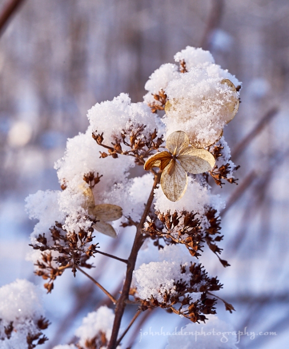
A dusting of snow on dried hydrangea
Morning Observation:
This morning in Huntington at 7:15AM it’s currently 8 degrees under clear skies. Winds are calm. Relative humidity is 87%, dewpoint 5, barometric pressure 30.31” and rising rapidly. We have 14.5” of snow at the stake. Yesterday’s high was a lovely 35, and the overnight low was 7.
Forecast:
We’ve got another lovely early spring day on tap today as building high pressure pushes daytime highs into the mid to upper 30s with plenty of sunshine. Weakening low pressure moving out of the Great Lakes will lift a warm front through the region tonight bringing snow to the region by Sunday morning. Snow will mix with sleet at times before transitioning to rainfall during the late morning/early afternoon hours. We could see a couple of inches of snowfall locally with 2″-4″ possible over portions of the northern ‘Dacks. We’ll also be seeing southeast winds gusting to from 25 to 40 mph along the western slopes of the Greens Sunday. Rain should transition back to snow Monday as a cold front sweeps through on the backside of the departing low. Temperatures will be on the rise through the week with afternoon highs warming into the 50s to near 60 on Thursday and Friday. It seems spring might actually be coming…
We’ll see sunny skies today with a high near 34 and north winds 3 to 6 mph. Tonight should bring increasing clouds with a 30% chance of snow, mainly after 4:00am. Lows will be around 18, increasing towards daybreak. It’ll be breezy with light east winds becoming southeasterly 17 to 22 mph in the evening and gusting to 36 mph. New snow accumulation of less than 1/2″ is expected.
Sunday should be cloudy with snow before noon, mixing with rain midday, then just plain rain in the afternoon. Highs will be near 39 with southeast winds 22 to 26 mph gusting to 46 mph. Chance of precipitation is 90% with new snow accumulation of 1″ to 2″ possible before the transition to rain. Sunday night will be cloudy with rain tapering to showers. Lows will be around 32 with south winds 9 to 14 mph becoming southwesterly after midnight. Chance of precipitation is 80% with new precipitation amounts of less than 1/10″ expected.
Monday should be mostly cloudy with a 30% chance of rain, mixing with snow after 5pm. High will be near 39 with west winds 13 to 16 mph and gusting to 31 mph. Little or no snow accumulation is expected. Monday night snow showers are likely. It’ll be cloudy with a low around 20 and northwest winds around 10 mph gusting to 22 mph. Chance of precipitation is 60% with little or no snow accumulation expected.
Almanac:
Last year on this date we had a high of 36 and a low if 25. We picked up 5″ of new snow and had 12″ at the stake.
Burlington averages for this date are a low of 19 and a high of 37.
The record low was -15 in 2007 (we had a low of -7).
The record high was 70 in 2016 (we had a high of 68).
Sky Notes:
Sunrise: 6:15AM
Sunset: 5:50PM
Length of day: 11:34:36
Today will be 3:04 longer than yesterday.
Daylight Savings Time (not a big fan of this artificial time change…) begins Sunday morning at 2:00AM (or is it 3:00AM? What happens to 2:27? I’m needlessly confused…) so remember to “spring” your clocks forward an hour before going to bed. (Or not. Your choice. Live in your own time man, it’s apparently arbitrary.)
The Moon is a waxing crescent, 2.4 days old with 6.5% illumination.
Moonrise: 7:55AM
Sunset: 8:52PM
About Today’s Photo:
The dried remains of last season’s hydrangea blooms on our back patio were dusted with a layer of fluffy snow the other day as the first rays of morning sunlight hit them.
Panasonic GX8, Olympus 60mm macro lens, ISO 400, f/8, 1/125″ exposure.
Friday, March 8, 2019

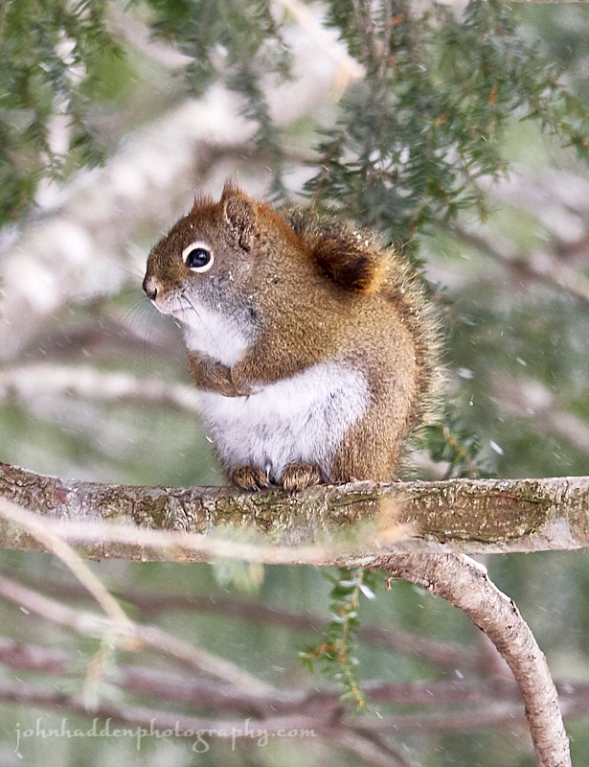
A red squirrel rests in our hemlock
Morning Observation:
This morning in Huntington at 6:40AM it’s currently -2 degrees under clear skies. Winds are calm. Relative humidity is 86%, dewpoint -5, barometric pressure 30.34” and steady. We picked up a 0.2” dusting of new snow in the past 24hrs and have 15” at the stake. Yesterday’s high was 18, and the overnight low was -2.
Forecast:
After a chilly start this morning, we’ll finally be seeing more seasonable conditions today as temperatures bump up into the upper 20s and lower 30s by this afternoon along with plenty of sunshine. Saturday should follow suit with high temperatures in the upper 20s to upper 30s. On Sunday, a surface low will track across the Great Lakes driving a frontal boundary through the North Country and bringing a mix of snow and rain. Precipitation should start at snow early Sunday morning, then mix with rain in the Champlain Valley, then wrap up with snow overnight Sunday into Monday as a cold front swings through on the backside of the low. We could see a few inches of accumulation here in Huntington. Along with the precipitation, gusty winds are expected along the western slopes of the Greens on Sunday. Monday and Tuesday will trend slightly cooler, though seasonable. A more significant warming trend is expected middle to late next week with more precipitation expected going into next weekend.
We’ll see sunny skies today with a high near 30 and south winds 7 to 11 mph gusting to 21 mph. Tonight should be mostly clear with a low around 14 and south winds 5 to 13 mph becoming westerly after midnight.
Saturday should be sunny with a high near 33 and light and variable winds becoming northerly around 5 mph in the afternoon. Saturday night should bring increasing clouds with snow likely, mainly after 4:00am. Lows will be around 19 with light east winds becoming southeasterly 10 to 15 mph in the evening and gusting to 30 mph. Chance of precipitation is 60% with new snow accumulations of less than 1/2″ expected.
Sunday should be cloudy with snow in the morning, mixing with rain midday. Highs will be near 36 with southeast winds 13 to 20 mph gusting to 40 mph. Chance of precipitation is 100% with new snow accumulations of around 1″ expected. Sunday night should be cloudy with a 50% chance of rain and snow showers early, wrapping up with snow. Lows will be around 34 with south winds around 8 mph becoming southwesterly after midnight.
Almanac:
Last year on this date we had a high of 32 and a low of 26. We picked up 2.75″ of new snow and had 8″ at the stake.
Burlington averages for this date are a low of 19 and a high of 37.
The record low was -90 in 2007 (we had a low of -5).
The record high was 61 in 2012 (we had a high of 61).
Sky Notes:
Sunrise: 6:17AM
Sunset: 5:48PM
Length of day: 11:31:32
Today will be 3:03 longer than yesterday.
The Moon is a waxing crescent, 1.5 days old with 2.5% illumination.
Moonrise: 7:31AM
Moonset: 7:50PM
About Today’s Photo:
It’s not often that you see a red squirrel sit still for any length of time. This little guy was resting in the hemlock in our side yard (interestingly, on the exact same branch as the mourning doves in yesterday’s post), and he hung out there for several minutes with his little paws tucked in and tail pressed against his back as the snow fell. Despite their sometimes annoying behavior (taking up residence in the floor of my studio, eating through power cables, etc…) I can’t help but love these busy little rodents.
Panasonic GX8, Lumix 100-300mm lens @ 300mm, ISO 800, f/8, 1/320″ exposure.
