Thursday, April 7, 2016
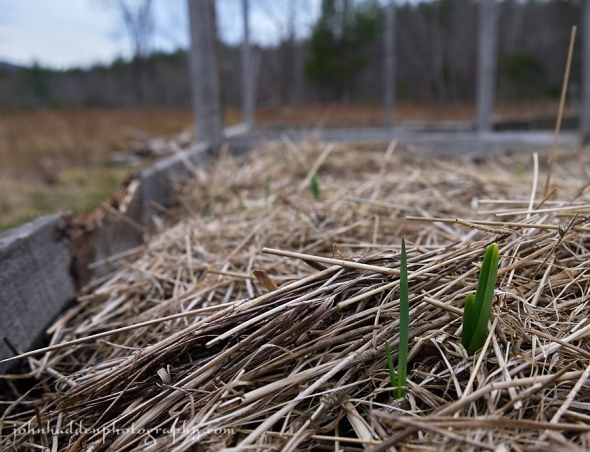
Shoots of garlic pop up from under their winter cover
Morning Observation:
This morning in Huntington at 7:00AM it’s currently 36 degrees under mostly cloudy skies. Winds are calm. Relative humidity is 81%, dewpoint 31, barometric pressure 29.69” and falling rapidly. We picked up 1.5” of new snow yesterday and have 1” on the ground this morning. Yesterday’s high was 39, and the overnight low was 35.
Forecast:
A complex area of low pressure will produce widespread rain across the region today and into tonight. Any morning snow showers will quickly change to rain and become heavy at times by mid afternoon with rainfall amounts between 0.50″ and 1.5″. Colder temperatures with scattered snow showers return by Friday into the weekend.
We’ll see a chance of rain showers this morning, then rain likely this afternoon. Highs will bump up into the mid 50s with south winds 15 to 20 mph gusting up to 30 mph. Chance of rain is near 100%. Rain will continue into tonight and may be heavy at times until midnight. Lows will be in the mid 30s with south winds 10 to 15 mph, becoming southwesterly after midnight. Chance of rain is near 100%.
Friday should be cloudy with a chance of mountain snow showers. Rain showers are likely, mainly in the morning, with snow accumulations of a dusting to 2″ possible over higher terrain. Temperature will remain near steady in the mid 30s with southwest winds 10 to 15 mph. Chance of precipitation is 60%. Friday night should be cloudy with a 50% chance of snow or rain showers. Lows will be in the lower 20s with west winds around 10 mph.
Saturday’s looking partly sunny with highs in the lower 30s and northwest winds around 10 mph. Saturday night should be partly cloudy and chilly with lows 15 to 20.
Almanac:
Last year on this date we had a high of 45 and a low of 23. We picked up 0.10″ of new snow and had 10″ at the stake.
Burlington averages for this date are highs of 50 and lows of 32.
The record high was 83°F in 1991.
The record low was 2°F in 1972.
Sky Notes:
Sunrise: 6:21 AM EDT
Sunset: 7:27 PM EDT
Length of Visible Light: 14h 05m
Length of Day: 13h 05m
Tomorrow will be 2m59s longer.
The Moon is new, 29d 9h old with 0% illumination.
Moonrise: 6:38 AM EDT
Moonset: 7:54 PM EDT
About Today’s Photo:
Our garlic is popping up!
Panasonic GX8, Lumix 14-140mm lens @ 14mm, ISO 800, f/4.2, 1/640″ exposure.
Wednesday, April 6, 2016
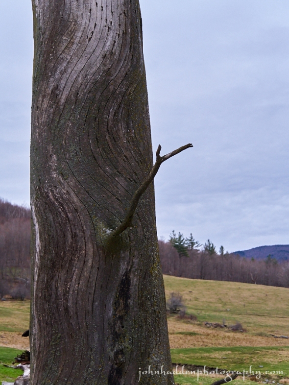
Twisted elm grain and greening fields near Taft Farm
Morning Observation:
This morning in Huntington at 7:20AM it’s currently 15 degrees under clear skies. Winds are calm. Relative humidity is 91%, dewpoint 13, barometric pressure 30.32” and falling slowly. Yesterday’s high was 32, and the overnight low was 13.
Forecast:
High pressure will shift southeast of New England by this afternoon. A southerly airflow will strengthen throughout the day between the departing high and low pressure developing across the southern Great Lakes region. A warm front will bring chances for rain or snow showers this afternoon through tonight as temperatures warm into the 30s. The main low tracking across southeastern Ontario and the St. Lawrence Valley will bring a widespread rain to the region during the day Thursday along with temperatures in the low to middle 50s. Another low will move in Friday bringing cooler air once again along with the chance of rain or snow showers.
We’ll see partly sunny skies this morning, becoming cloudy with a 50% chance of rain this afternoon. Highs will be in the upper 30s with south winds 10 to 15 mph. Tonight should be cloudy with a chance of rain or snow until midnight, then a chance of rain after midnight. Lows will be in the mid 30s with south winds 15 to 20 mph gusting up to 35 mph. Chance of precipitation is 50%.
Thursday rain showers are likely. Highs will be in the lower 50s with south winds 15 to 20 mph gusting up to 30 mph. Chance of rain is near 100%. Rain will continue into Thursday night. Lows will be in the mid 30s with light and variable winds. Chance of rain is near 100%.
Friday’s looking cloudy with a 50% chance of rain or snow showers. Highs will be in the lower 40s with southwest winds around 10 mph gusting up to 25 mph. Friday night should be cloudy with a 50% chance of snow or rain showers. Lows will be in the mid 20s.
Almanac:
Last year on this date we had a high of 37 and a low of 23. We had 9.5″ of snow at the stake.
Burlington averages for this date are highs of 50 and lows of 31.
The record high was 77°F in 1928.
The record low was 10°F in 1943.
Sky Notes:
Sunrise: 6:23 AM EDT
Sunset: 7:26 PM EDT
Length of Visible Light: 14h 02m
Length of Day: 13h 02m
Tomorrow will be 3m1s longer.
The Moon is a waning crescent, 28d 9h old with 1% illumination.
Moonrise: 6:01 AM EDT
Moonset: 6:38 PM EDT
About Today’s Photo:
The grain of this dead elm tree along Taft Road has always drawn my eye. Elm is notoriously hard to split. Beyond the tree, the fields are beginning to green.
Panasonic GX8, Lumix 14-140mm lens @ 30mm, ISO 800, f/4.4, 1/1000″ exposure.
Tuesday, April 5, 2016
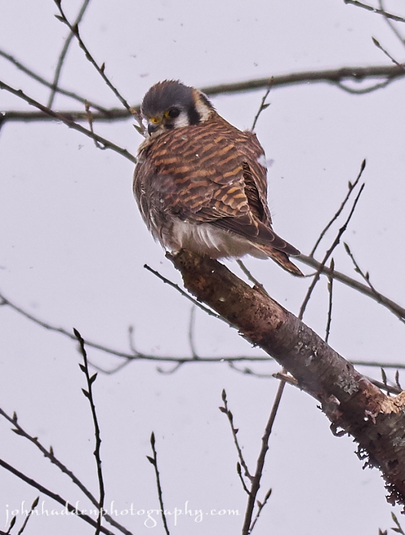
An American Kestel hunts along Shaker Mountain Road
Morning Observation:
This morning in Huntington at 7:35AM it’s currently a frosty 10 degrees under clear skies. Winds are calm. Relative humidity is 91%, dewpoint 8, barometric pressure 30.33” and rising rapidly. Though it snowed pretty consistently yesterday, we didn’t manage to pick up any accumulation. Yesterday’s high was 27, and the overnight low was 7.
Forecast:
High pressure will continue to bring unseasonably cold but dry weather today into early Wednesday. Low pressure and a leading warm front approaching from the Great Lakes will bring precipitation to the region starting the latter half of Wednesday through the end of the work week. Temperatures will moderate Wednesday and Thursday before a cold front on the backside of the low brings temperatures back into the 30s for the weekend.
We’ll see sunny skies today with highs in the upper 20s and northwest winds 10 to 15 mph. Tonight should be clear with lows around 14 and northwest winds around 10 mph until midnight, becoming light and variable.
Wednesday should start out partly sunny in the morning, then become cloudy with a 20% chance of rain or snow showers in the afternoon. Highs will be in the mid 30s with south winds 10 to 15 mph gusting to 30 mph in the afternoon. Wednesday night rain or snow showers likely with little or no snow accumulation. Lows will be in the mid 30s with south winds 10 to 15 mph gusting up to 35 mph. Chance of precipitation is 70%.
Thursday rain or snow showers are likely with little or no additional snow accumulation. Highs will be in the upper 40s with south winds 10 to 15 mph gusting up to 30 mph. Chance of precipitation is 90%. Thursday night rain or snow showers likely with little or no snow accumulation. Lows will be in the mid 30s. Chance of precipitation is 90%.
Almanac:
Last year on this date we had a high of 40 and a low of 21. We picked up 1.30″ of new snow and had 11″ at the stake.
Burlington averages for this date are highs of 49 and lows of 31.
The record high was 75°F in 1928.
The record low was 3°F in 1964.
Sky Notes:
Sunrise: 6:25 AM EDT
Sunset: 7:24 PM EDT
Length of Visible Light: 13h 58m
Length of Day: 12h 59m
Tomorrow will be 3m2s longer.
The Moon is a waning crescent, 27d 9h old with 6% illumination.
Moonrise: 5:26 AM EDT
Moonset: 5:22 PM EDT
About Today’s Photo:
I finally managed to get a good shot of an American Kestrel! This guy was hunting in the fields along Shaker Mountain Road yesterday at midday as the snow fell. Usaully these small raptors will fly away before I’ve even gotten my camera out, but this one was more patient with me, allowing me to snap off several shots before flying off.
Panasonic GX8, Lumix 100-300mm lens @ 300mm, ISO 400, f/7.1, 1/1000″ exposure.
Monday, April 4, 2016
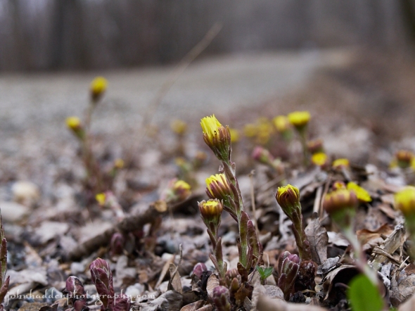
Coltsfoot in its natural habitat—along the roadside
Morning Observation:
This morning in Huntington at 8:20AM it’s currently 18 degrees under overcast skies. A few lazy snowflakes are drifting down. Winds are calm. Relative humidity is 70%, dewpoint 9, barometric pressure 30.06” and rising slowly. Yesterday’s high was 32, and the overnight low was 12.
Forecast:
A low pressure system will track from southern Michigan early this morning to Long Island by this evening bringing light snow across the southern portions of Essex County New York and areas south of Montpelier in Vermont. Any snow accumulations in these areas will be less than an inch. Below normal temperatures will continue across the region today and on into Tuesday with highs only in the middle 20s to lower 30s.
We’ll see cloudy skies today with a 20% chance of light snow this morning. Highs will be in the upper 20s with light and variable winds, becoming northerly around 10 mph this afternoon. Tonight should be partly cloudy until midnight, then clearing. Lows will be around 12 with north winds around 10 mph.
Tuesday should be sunny and continued chilly with highs in the mid 20s and northwest winds 10 to 15 mph. Tuesday night should be clear with lows around 15 and northwest winds around 10 mph.
Wednesday’s looking partly sunny with a 50% chance of rain in the afternoon as a warm front approaches from the west. Highs will be in the upper 30s with south winds 10 to 15 mph gusting up to 30 mph. Wednesday night rain is likely. Lows will be in the mid 30s. Chance of rain is 70%.
Almanac:
Last year on this date we had a high of 44 and a low of 23. We picked up 0.27″ of rain and 1.25″ of snow and had 9.50″ of snow at the stake.
Burlington averages for this date are highs of 49 and lows of 30.
The record high was 73°F in 1981.
The record low was 6°F in 1911.
Sky Notes:
Sunrise: 6:26 AM EDT
Sunset: 7:23 PM EDT
Length of Visible Light: 13h 55m
Length of Day: 12h 56m
Tomorrow will be 3m1s longer.
The Moon is a waning crescent, 26d 10h old with 12% illumination.
Moonrise: 4:50 AM EDT
Moonset: 4:08 PM EDT
About Today’s Photo:
Coltsfoot—one of the first blooms of the season—just seems to love the gravely shoulders of our dirt roadsides. The sides of Taft Road have quite a bit of it flowing now, though, with this morning’s chilly temperatures, I’m sure it’s all tucked up safely against the cold.
Panasonic GX8, Lumix 14-140mm lens @ 46mm, ISO 800, f/4.9, 1/2000″ exposure.
Sunday, April 3, 2016
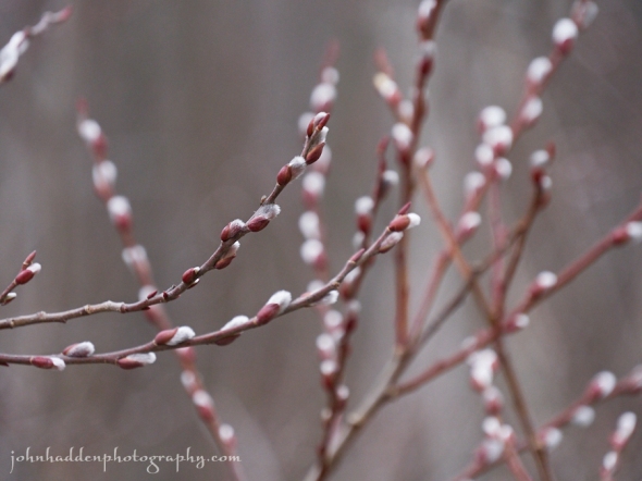
Budding willows along Taft Road
Morning Observation:
This morning in Huntington at 8:00AM it’s currently 23 degrees under mostly cloudy skies. Winds are out of the northwest at 5-10 mph. Relative humidity is 64%, dewpoint 13, barometric pressure 29.53” and rising rapidly. We picked up a 0.01” trace of rain in the past 24hrs. Yesterday’s high was 52, and the overnight low was 23.
Forecast:
The passage of yesterday’s cold front has ushered much colder air into the region, making for below average temperatures that will persist for the next several days. A trough of low pressure will pass to our south tonight bringing the chance of some snow to southern Vermont and a reinforcing shot of cold air region-wide. Surface high pressure will crest over the region Tuesday and Tuesday night keeping temperatures cold while clearing the skies.
We’ll see mostly cloudy skies this morning, then partly sunny skies later today. It’ll be blustery with highs only in the mid 20s and northwest winds 15 to 25 mph gusting up to 45 mph. Sunday night should be partly cloudy with lows around 14 and northwest winds 15 to 20 mph gusting up to 35 mph and diminishing to around 10 mph after midnight.
Monday should be mostly cloudy with highs in the upper 20s and light and variable winds, becoming northerly around 10 mph in the afternoon. Monday night should be partly cloudy with lows around 11 and north winds around 10 mph.
Tuesday’s looking mostly sunny with highs in the upper 20s and northwest winds 10 to 15 mph gusting up to 25 mph. Tuesday night should be clear with lows around 15.
Almanac:
Last year on this date we had a high of 64 and a low of 36. We picked up 0.01″ of rain and had 11.50″ of snow at the stake.
Burlington averages for this date are highs of 48 and lows of 30.
The record high was 82°F in 2010 (we had a high of 83).
The record low was 7°F in 1911.
Sky Notes:
Sunrise: 6:28 AM EDT
Sunset: 7:22 PM EDT
Length of Visible Light: 13h 52m
Length of Day: 12h 53m
Tomorrow will be 3m2s longer.
The Moon is a waning crescent, 25d 10h old with 21% illumination.
Moonrise: 4:11 AM EDT
Moonset: 2:57 PM EDT
About Today’s Photo:
The willows bordering the wetland along Taft Road were budding nicely yesterday morning.
Panasonic GX8, Lumix 14-140mm lens @ 140mm, ISO 800, f/5.6, 1/640″ exposure.
Saturday, April 2, 2016

Daffodils on the verge of flowing in our ornamental garden
Morning Observation:
This morning in Huntington at 9:00AM it’s currently 40 degrees under cloudy skies. Winds are calm. Relative humidity is 76%, dewpoint 33, barometric pressure 29.49” and falling. We picked up 0.52” of rain in the past 24hrs. Yesterday’s high was 66, and the overnight low was 35.
Forecast:
If yesterday was a bit of a trickster weather-wise, the next 24 hours will prove to be even trickier. An upper level trough of low pressure will bring a wide variety of weather to the area this weekend. First up will be scattered to numerous showers from late morning through early evening as a cold front associated with the trough moves across the region. Some of the showers may contain very small hail and gusty winds. Noticeably colder air is expected tonight and as the trough moves across the area. The potential for snow showers
will exist with some minor accumulations possible over southern Vermont by Sunday morning. Any snow showers will come to an end Sunday morning with temperatures expected to be well below normal. Highs will only be in the middle 20s to lower 30s with gusty northwest winds that will make it feel even colder.
We’ll see partly sunny skies this morning, then mostly cloudy skies with rain showers likely this afternoon. Highs will be in the lower 50s with southwest winds 10 to 15 mph. Chance of rain is 70%. Tonight should be partly cloudy with a chance of rain showers until midnight, then mostly cloudy with a chance of snow showers after midnight. Lows will be in the lower 20s with northwest winds around 10 mph and gusting up to 25 mph until midnight. Chance of precipitation is 40%.
Sunday should be cloudy with a 20% chance of snow showers in the morning, then partly sunny in the afternoon. It’ll be blustery with highs in the upper 20s and northwest winds 20 to 25 mph gusting up to 40 mph in the afternoon. Sunday night should be partly cloudy with lows around 12 and northwest winds 15 to 20 mph gusting up to 35 mph.
Monday’s looking mostly cloudy with highs only in the upper 20s and light and variable winds. Monday night should be partly cloudy with lows 10 to 15.
Almanac:
Last year on this date we had a high of 58 and a low of 18. We had 14.50″ of snow at the stake.
Burlington averages for this date are highs of 48 and lows of 29.
The record high was 79°F in 2010 (we had a high of 80).
The record low was 10°F in 1911.
Sky Notes:
Sunrise: 6:30 AM EDT
Sunset: 7:21 PM EDT
Length of Visible Light: 13h 49m
Length of Day: 12h 50m
Tomorrow will be 3m3s longer.
The Moon is a waning crescent, 24d 11h old with 30% illumination.
Moonrise: 3:30 AM EDT
Moonset: 1:49 PM EDT
About Today’s Photo:
Though there are flowers blooming down in the “banana belt” of the valley, ours have yet to flower. They’re getting there though!
Panasonic GX8, Lumix 14-140mm lens @ 14mm, ISO 800, f/4.2, 1/250″ exposure.
Friday, April 1, 2016
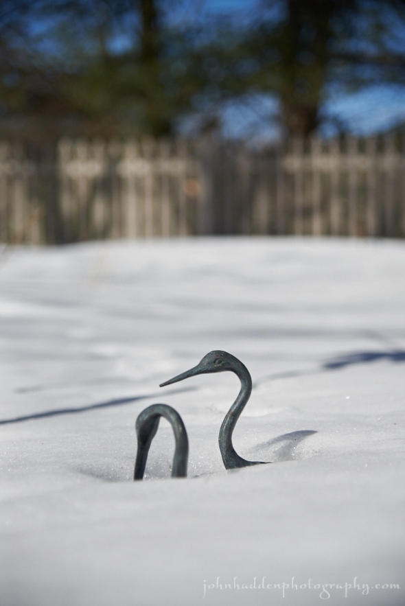
Overnight snows brought in these two cranes. Not sure on the species…
Rabbit-rabbit!
Morning Observation:
This morning in Huntington at 7:00AM it’s currently a balmy, and indeed foolish, 64 degrees. Winds are gusting out of the south at 5-15 mph. Relative humidity is 69%, dewpoint 54, barometric pressure 29.47”. Yesterday’s high was 65, and the overnight low was 63.
Forecast:
Big, foolish changes in our weather coming in the next 48 hours. Low pressure heading into central Québec early this morning will drag a cold front through the region today kicking off showers and possible rumbles of thunder this afternoon into Saturday. An Arctic cold front will swing down Saturday night bringing in much colder air that will remain with us into next week.
We’ll see showers today with a slight chance of thunderstorms this afternoon. It’ll be breezy with highs in the mid 60s and southwest winds 15 to 25 mph gusting up to 40 mph, then becoming westerly 10 to 15 mph with gusts up to 25 mph this afternoon. Chance of rain is 90%. Tonight should be mostly cloudy with a 40% chance of rain showers until midnight, then partly cloudy after midnight. Lows will be in the upper 30s with west winds 15 to 20 mph gusting up to 30 mph and diminishing to around 10 mph after midnight.
Saturday should be partly sunny in the morning, then become cloudy with a 50% chance of rain showers. Highs will be in the lower 50s with southwest winds 10 to 15 mph. Saturday night should be mostly cloudy with a 50% chance of rain or snow showers. Lows will drop into the lower 20s with northwest winds around 10 mph.
Sunday’s looking partly sunny with a 40% chance of snow showers. Highs will only be in the upper 20s with northwest winds 15 to 20 mph gusting up to 35 mph. Sunday night should be partly cloudy with lows 10 to 15.
Almanac:
Last year on this date we had a high of 37 and a low of 13. We had 14.50″ of snow at the stake.
Burlington averages for this date are highs of 47 and lows of 29.
The record high was 75°F in 1986.
The record low was 5°F in 1923.
Sky Notes:
Sunrise: 6:32 AM EDT
Sunset: 7:19 PM EDT
Length of Visible Light: 13h 46m
Length of Day: 12h 47m
Tomorrow will be 3m3s longer.
The Moon is a waning crescent, 23d 9h old with 42% illumination.
Moonrise: 2:46 AM EDT
Moonset: 12:45 PM EDT
About Today’s Photo:
April Fools!
