Thursday, May 31, 2018

Blueberries blossoms in Algonquin
Morning Observation:
This morning in Huntington at 7:05AM it’s currently a balmy 67 degrees under partly cloudy skies. Winds are out of the north at 0-4 mph. Relative humidity is 39%, dewpoint 41, barometric pressure 30.00” and steady. Yesterday’s high was 88, and the overnight low was 60.
Forecast:
The high pressure that’s been delivering clear and comfortable conditions is sliding to our east this morning. Humidity levels will build today and
tomorrow out ahead of an approaching low pressure system and associated cold front approaching from the Great Lakes. Clouds will be on the increase through the day today with scattered showers possible west this afternoon. Widespread showers and thunderstorms will be on tap from Friday as the cold front swings through. High pressure will build in on Saturday bringing cooler and drier conditions through the weekend.
We’ll see sunny to partly cloudy skies today with a stray shower or thunderstorm is possible west this afternoon. Highs will be around 84F with SSW winds at 10 to 15 mph. Tonight should be partly cloudy this evening giving way to cloudy skies and rain overnight. Lows will be around 68F with SSW at 10 to 15 mph. Chance of rain is 70%.
Friday should bring widespread showers and thunderstorms. Highs will be around 81F with SW winds at 5 to 10 mph. Chance of rain is 90%. Friday night should be overcast with a slight chance of showers and thunderstorms, mainly during the evening. Lows will be around 60F with NNW winds at 5 to 10 mph. Chance of rain is 30%.
Saturday’s looking partly to mostly cloudy with highs around 75F and north winds at 10 to 15 mph. Saturday night should be mostly clear with lows arond 51F and ENE winds at 5 to 10 mph.
Almanac:
Last year on this date we had a high of 74 and a low of 49. We picked up 0.33″ of rain.
Burlington averages for this date are a high of 72 and lows of 50.
The record high was 91°F in 2013 (we had a high of 89).
The record low was 25°F in 1961.
Sky Notes:
Sunrise: 5:12AM
Sunset: 8:29PM
Length of Visible Light: 16h 27m
Length of Day: 15h 16m
Tomorrow will be 1 minutes 23 seconds longer
The Moon is waning gibbous, 16.3 days old with 97% illumination.
Moonrise: 10:17PM
Moonset: 6:53AM
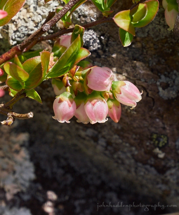
About Today’s Photo:
Algonquin Provincial Park in Ontario is almost at the same lattitude as Huntington—just a tad farther north at around 45 degrees north lattitude. We felt right at home there in the mixed hardwood forests, conifer forests, and numerous ponds and lakes. These blueberry blossoms caught my eye as we hiked. Future yummy bites for another hiker or critter.
Panasonic GX8, Lumix 14-140mm lens @ 140mm, ISO 800, f/8, 1/800″ exposure.
Wednesday, May 30, 2018


Trout lily blooming
Morning Observation:
This morning in Huntington at 7:15AM it’s currently 52 degrees under clear skies. Winds are calm. Relative humidity is 98%, dewpoint 52, barometric pressure 30.13” and rising slowly. Yesterday’s high was 78, and the overnight low was 44.
Forecast:
We’ve got a delightful day on tap courtesy of high pressure currently cresting over the region. We’ll see dry conditions and above normal temperatures today into Thursday. Humid and muggy conditions will build in on Thursday out ahead of low pressure—and the remnants of tropical storm Alberto—approaching from the Great Lakes. We’ll see widespread rain and some afternoon thunderstorms moving through on Friday and early Saturday. High pressure should build back in Saturday into Sunday bringing more seasonable and dry conditions.
We’ll see partly cloudy skies today with highs near 82F and SSE at 10 to 15 mph. Tonight should be partly cloudy and warm with lows near 60F and south winds at 5 to 10 mph.
Thursday should start out partly cloudy with a stray shower or thunderstorm possible in the afternoon. Highs will be around 81F with south winds at 10 to 15 mph. Thursday night should be partly cloudy early followed by increasing clouds and showers developing later at night. Lows will be around 66F with SSW winds at 10 to 15 mph. Chance of rain is 50%.
Friday showers and thunderstorms are likely. Highs will be around 78F with SW winds at 5 to 10 mph. Chance of rain is 90%. Friday night should bring scattered thunderstorms in the evening tapering to cloudy skies overnight. Lows will be around 56F with NNW winds at 5 to 10 mph. Chance of rain is 50%.
Almanac:
Last year on this date we had a high of 66 and a low of 54. We picked up 0.75″ of rain.
Burlington averages for this date are a high of 72 and lows of 50.
The record high was 92°F in 1929.
The record low was 28°F in 1961.
Sky Notes:
Sunrise: 5:13AM
Sunset: 8:28PM
Length of Visible Light: 16h 25m
Length of Day: 15h 14m
Tomorrow will be 1 minutes 27 seconds longer
The Moon is waning gibbous, 15.4 days old with 99% illumination.
Moonrise: 9:25PM
Moonset: 6:11AM
About Today’s Photo:
While trout lilies have long since bloomed and set fruit here in Vermont, up in Agonquin Provincial Park in Ontario—where we were last week—they were still in bloom. Of all the “spring ephemerals” I think trout lily is my favorite. It’s graceful pendant flowers are a particulary sensitive to temperature, staying tightly bundled in cooler conditions and unfurling and curling back its petals when the air is warm. They also come in a variety of different colors from orange to this yellow bloom.
Panasonic GM5, Lumix 12-32mm lens @ 32mm, ISO 800, f/8, 1/800″ exposure.
Tuesday, May 29, 2018


A red eft makes its way through the grass near our pond
We’re back after some extende Spring travel!
Morning Observation:
This morning in Huntington at 7:40AM it’s currently 62 degrees under overcast skies. Winds are calm. Relative humidity is 98%, dewpoint 62, barometric pressure 29.97” and rising slowly. We picked up 0.01” of rain overnight. Yesterday’s high was 75, and the overnight low was 57.
Forecast:
Warmer and dry conditions will move into the region today as high pressure builds in from the west. We can expect above normal temperatures with clear to partly cloudy skies until Thursday. Our next chance for rainfall returns later Thursday as low pressure and the remnants of tropical storm Alberto approaches from the Ohio River valley.
We’ll see mostly cloudy skies early with sunshine for the afternoon. Highs will be near 75F with NNW winds at 5 to 10 mph. Tonight should be clear to partly cloudy with lows around 54F and east winds at 5 to 10 mph.
Wednesday should be partly cloudy with highs near 80F and south winds at 5 to 10 mph. Wednesday night should be partly cloudy with lows around 59F and south winds at 5 to 10 mph.
Thursday should bring partly cloudy skies in the morning with more clouds for later in the day and a stray shower or thunderstorm is possible late. Highs will be around 79F with south winds at 10 to 15 mph. Thursday night
should be partly cloudy in the evening giving way to cloudy skies overnight. Lows will be around 64F with south winds at 5 to 10 mph.
Almanac:
Last year on this date we had a high of 60 and a low of 53. We picked up 0.27″ of rain.
Burlington averages for this date are a high of 71 and lows of 50.
The record high was 89°F in 1978.
The record low was 34°F in 1970.
Sky Notes:
Sunrise: 5:14AM
Sunset: 8:27PM
Length of Visible Light: 16h 23m
Length of Day: 15h 13m
Tomorrow will be 1 minutes 30 seconds longer
The Moon is the full “Flower” moon (Northeast Native American)
14.5 days old with 100% illumination.
Moonrise: 8:28PM
Moonset: 5:34AM
About Today’s Photo:
If you walk through the woods after a rain you’re sure to spot one of these bright orange salamanders. The red eft is the the juvenile stage of the common eastern newt. An eft will wonder the woods for two or three years before retuning to a pond, changing its coloration to the familiar olive green, and breeding. The orange color of the eft is an example of aposematism — or “warning coloration” — that lets predators know that its body contains toxins that are unpalatable.
Panasonic GX8, Olympus 60mm macro lens, ISO 800, f/8, 1/250″ exposure.
Saturday, May 12, 2018

Our resident tree swallow on his perch
Morning Observation:
This morning in Huntington at 6:50AM it’s currently 32 degrees under mostly clear skies. We have some light frost in our front field. Relative humidity is 93%, dewpoint 30, barometric pressure 30.19” and steady. Yesterday’s high was 61, and the overnight low was 30.
Forecast:
A warm front south of New England will allow low pressure to track well south of our region bringing a chance of showers to far southern Vermont today with just high clouds expected elsewhere. Temperatures should bump into the mid 60s locally today with another chance of frost tonight. Extensive high pressure will build in Sunday bringing sunshine and seasonal temperatures going well into next week.
We’ll see partly cloudy skies today with highs around 64F and WSW winds at 5 to 10 mph. Tonight should be partly cloudy with lows in the mid 30s and light and variable winds. Some frost may occure in cold pockets.
Sunday should be partly cloudy with highs near 70F and south winds at 5 to 10 mph. Sunday night should be partly cloudy with lows around 52F and SSW winds at 5 to 10 mph.
Monday’s looking partly cloudy with highs around 77F and SW winds at 10 to 15 mph. Monday night should be mostly clear with lows near 55F and light and variable winds.
Almanac:
Last year on this date we had a high of 71 and a low of 35.
Burlington averages for this date are a high of 66 and a low of 44.
The record high was 84°F in 2004 (we had a high of 83).
The record low was 28°F in 1963.
Sky Notes:
Sunrise: 5:29AM
Sunset: 8:09PM
Length of Visible Light: 15h 46m
Length of Day: 14h 39m
Tomorrow will be 2 minutes 18 seconds longer
The Moon is a waning crescent, 26 days old with 12.8% illumination.
Moonrise: 4:18AM
Moonset: 4:52PM
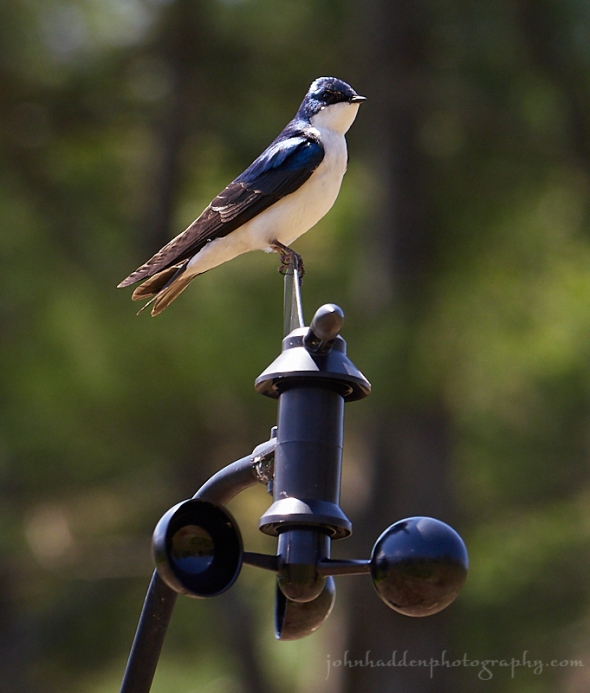
About Today’s Photo:
As I mentioned yesterday, we have a pair of tree swallows moving in to one of the nesting boxes in our front field. I just love to watch these aerial acrobats swoop and glide as they go after bugs. My weather station is just a couple dozen yards from the box, and the anemometer makes for a convenient perch for perusing the landscape. Mr. Swallow allowed me to take a nice portrait.
Panasonic GX8, Lumix 100-300mm lens @ 188mm, ISO 800, f/8, 1/320″ exposure.
Friday, May 11, 2018
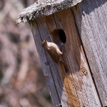
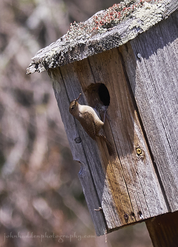
A house wren moving in to one of our boxes in the front field
Morning Observation:
This morning in Huntington at 7:50AM it’s currently 41 degrees under partly cloudy skies. Winds are out of the west at 2-5 mph. Relative humidity is 61%, dewpoint 28, barometric pressure 30.01” and rising rapidly. We didn’t get a drop of rain here in the past 24hrs. Yesterday’s high was 76, and the overnight low was 38.
The National Weather Service has posted an advisory concerning dry ground conditions and the potential for any fires to spread quickly. Please use caution if you’re going to burn today.
Forecast:
Cool and dry weather is expected today as high pressure builds down from Canada. A frontal boundary south of the region may spread some showers into central and southern Vermont and parts of the Northern ‘Dacks on Saturday, otherwise, we’ll remain dry to the north. Areas of frost are a potential Saturday night. Warmer and drier weather returns for Sunday going into next week.
We’ll see mostly sunny skies today. It’ll be on the cool side with highs only around 53F and NW winds at 10 to 20 mph. Tonight should be partly cloudy with lows around 36F and NNW winds at 5 to 10 mph.
Saturday should be cloudy early, followed by partial clearing. Highs will be near 55F with south winds at 5 to 10 mph. Saturday night should be lear to partly cloudy with lows around 38F and light and variable. Some frost is possible in the ‘Dacks and NEK.
Sunday’s looking partly cloudy with highs around 68F and NW winds at 5 to 10 mph. Sunday night should be partly cloudy with lows around 48F and south winds at 5 to 10 mph.
Almanac:
Last year on this date we had a high of 63 and a low of 38.
Burlington averages for this date are a high of 66 and lows of 44.
The record high was 90°F in 1911.
The record low was 27°F in 1962.
Sky Notes:
Sunrise: 5:30AM
Sunset: 8:08PM
Length of Visible Light: 15h 43m
Length of Day: 14h 37m
Tomorrow will be 2 minutes 20 seconds longer
The Moon is a waning crescent, 25 days old with 20% illumination.
Moonrise: 3:50AM
Moonset: 3:45PM
About Today’s Photo:
We have two bird boxes in our front field. While they were originally intended for bluebirds, we’ve often had tree swallows move in to one with bluebirds in the other. The past two summers we’ve hosted tree swallows in one and now it looks like house wrens again in the second. These chattery little birds are quite fun to watch as they forage for nesting materials. When I cleaned this box out in March, I found their well built nest of twigs lined with milk weed fluff, rootlets, and other soft materials.
Panasonic GX8, Lumix 100-300mm lens @ 300mm, ISO 800, f/8, 1/1000″ exposure.
Thursday, May 10, 2018

A magnolia blossom in our back garden
Morning Observation:
This morning in Huntington at 7:50AM it’s currently 67 degrees under clear skies. Winds are out of the east at 2-4 mph. Relative humidity is 43%, dewpoint 43, barometric pressure 29.84” and falling rapidly. Yesterday’s high was a sultry 81, and the overnight low was 49.
Forecast:
A upper shortwave trough and associated cold front approaching from the northern Great Lakes will bring increasing clouds this morning and scattered showers starting by midday. There is a slight chance of thunderstorms as well, mainly during the afternoon hours, with a threat for lightning and wind gusts of 30 to 40 mph with any stronger storm cores. Cooler and drier weather will return on Friday going into the weekend.
We’ll see sunny skies this morning giving way to increasing clouds with periods of showers by midday with thunder possible this afternoon. Highs will be around 72F with south winds at 10 to 20 mph. Chance of rain is 40%. Tonight showers early should taper to cloudy skies overnight. Lows will be around 42F with WNW winds at 10 to 15 mph. Chance of rain is 60%.
Friday should start off partly cloudy, then become mostly sunny. It’ll be on the cool side with highs only around 56F with NW winds at 10 to 15 mph. Friday night should be partly cloudy with lows around 38F and light and variable winds.
Saturday should start out cloudy early, followed by partial clearing. There’s a slight chance of a rain shower south. Highs will be around 60F with SSE winds at 5 to 10 mph. Saturday night should be partly cloudy with a slight chance of a rain shower. Lows will be around 39F with light and variable winds.
Almanac:
Last year on this date we had a high of 53 and a low of 36. We picked up 0.02″ of rain.
Burlington averages for this date are a high of 65 and lows of 43.
The record high was 89°F in 2007 (we had a high of 87).
The record low was 25°F in 1947.
Sky Notes:
Sunrise: 5:31AM
Sunset: 8:07PM
Length of Visible Light: 15h 41m
Length of Day: 14h 35m
Tomorrow will be 2 minutes 22 seconds longer
The Moon is a waning crescent, 24 days old with 29% illumination.
Moonrise: 3:23AM
Moonset: 2:40PM
About Today’s Photo:
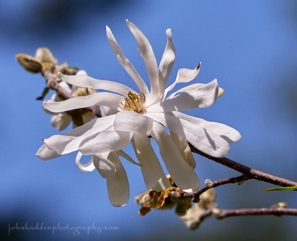
The magnolia tree in our back yard is in full bloom right now. It’s always a treat to watch the fat furry buds on this tree crack open and burst like slow motion fireworks. The blossoms are already starting to fall apart…
Panasonic GX8, Lumix 100-300mm lens @ 218mm, ISO 800, f/8, 1/5000″ exposure.
Wednesday, May 9, 2018

Wild oats blooming in the woods
Morning Observation:
This morning in Huntington at 7:55AM it’s currently 58 degrees under clear skies. Winds are calm. Relative humidity is 70%, dewpoint 48, barometric pressure 30.16” and steady. Yesterday’s high was 76, and the overnight low was 41.
Forecast:
High pressure continues to rule the roost with clear skies and fair conditions through tonight. Temperatures will be several degrees warmer
today, with afternoon valley highs in the upper 70s to lower 80s. A cold front will cross the region later Thursday bringing scattered showers and a slight chance of a thunderstorm Thursday afternoon and night. Cooler weather will return for Friday, with a renewed threat for rain showers on Saturday.
We’ll see sunny skies today with highs around 78F and SSW winds at 5 to 10 mph. Tonight should be clear with lows around 54F and SE winds at 5 to 10 mph.
Thursday should start out mostly sunny for the morning hours, then give way to clouds and occasional showers in the afternoon with a rumble of thunder possible. Highs will be around 71F with south winds at 10 to 20 mph. Chance of rain is 50%. Thursday night should be partly cloudy after some evening light rain. Lows will be around 40F with WNW winds at 10 to 20 mph. Chance of rain is 70%.
Friday’s looking mostly sunny with highs around 58F and NW winds at 10 to 15 mph. Friday night should be partly cloudy in the evening, becoming cloudy overnight with a slight chance of a rain shower. Lows will be around 42F with light and variable winds.
Almanac:
Last year on this date we had a high of 48 and a low of 33. We picked up 0.06″ of rain.
Burlington averages for this date are a high of 65 and lows of 43.
The record high was 92°F in 1979.
The record low was 28°F in 1950.
Sky Notes:
Sunrise: 5:33AM
Sunset: 8:06PM
Length of Visible Light: 15h 38m
Length of Day: 14h 32m
Tomorrow will be 2 minutes 24 seconds longer
The Moon is a waning crescent, 23 days old with 38% illumination.
Moonrise: 2:53AM
Moonset: 1:37PM
About Today’s Photo:
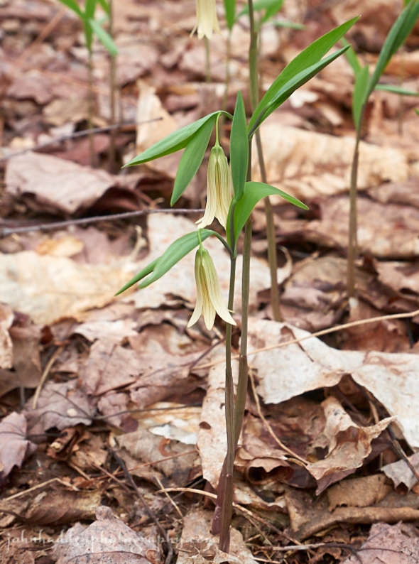
Sessile bellwort—a.k.a. wild oats—is blooming now in the shaded hardwood forests. These graceful yellow flowers spread asexually via extensive underground root systems to form large colonies that can carpet the forest floor. There are several such colonies up by a nearby beaver pond.
Panasonic GM5, Lumix 12-32mm lens @ 32mm, ISO 400, f/8, 1/400″ exposure.
Tuesday, May 8, 2018


Purple trillium in bloom along Taft Road
Morning Observation:
This morning in Huntington at 7:25AM it’s currently 44 degrees under clear skies. Winds are calm. Relative humidity is 88%, dewpoint 41, barometric pressure 30.24” and steady. Yesterday’s high was 64, and the overnight low got down to 33.
Forecast:
We’ve got another lovely and warmer day on tap courtesy of high pressure parked over the region. We’ll see fair skies and warming temperatures through Wednesday. A cold front will cross the region later Thursday bringing showers and possibly an isolated thunderstorm or two. Cooler conditions will return behind the departing front for the weekend with a renewed threat of showers Sunday.
We’ll see sunny skies today with highs around 73F and SW winds at 5 to 10 mph. Tonight should be clear with lows near 50F and light and variable winds.
Wednesday should be mostly sunny with highs around 77F and SSE winds at 5 to 10 mph. Wednesday night should be clear with lows around 55F and SE winds at 5 to 10 mph.
Thursday should start out sunny early then become mostly cloudy with showers developing later in the day. Some rumbles of thunder are possible. Highs will be around 72F with south winds at 10 to 20 mph. Chance of rain is 50%. Thursday night rain should end early giving way to partly cloudy skies late. Lows will be around 38F with WNW winds at 10 to 20 mph. Chance of rain is 80%.
Almanac:
Last year on this date we had a high of 45 and a low of 33. We picked up 0.15″ of rain.
Burlington averages for this date are a high of 65 and lows of 43.
The record high was 89°F in 1936.
The record low was 25°F in 1962.
Sky Notes:
Sunrise: 5:34AM
Sunset: 8:04PM
Length of Visible Light: 15h 35m
Length of Day: 14h 30m
Tomorrow will be 2 minutes 26 seconds longer
The Moon is a waning crescent, 22 days old with 48% illumination.
Moonrise: 2:21AM
Moonset: 12:36PM
About Today’s Photo:
Purple trillium—a.k.a. wake-robin—is blooming now in shady forest locations. It’s a favorite spring ephemeral with its regally colored petals and complex center.
Panasonic GM5, Olympus 60mm macro lens, ISO 400, f/8, 1/125″ exposure
Monday, May 7, 2018

A mourning cloak emerges from the leaf litter
Morning Observation:
This morning in Huntington at 7:50AM it’s currently 48 degrees under clear skies. Winds are out of the west at 4-6 mph. Relative humidity is 64%, dewpoint 36, barometric pressure 30.10” and rising rapidly. We picked up just a trace of rain overnight. Yesterday’s high was 68, and the overnight low was 42.
Forecast:
We’ve got a lovely few days ahead of us courtesy of high pressure which is currently building into the region. Sunny skies and seasonable temperatures will be the rule through Wednesday before the next low pressure system arrives on Thursday bringing showers. Some patchy frost is possible in the protected valleys of northern New York and parts of central and northern Vermont tonight. Temperatures will be on the cool side today and warm into the 70s by midweek.
We’ll see sunny skies today with highs around 61F and NNW winds at 5 to 10 mph. Tonight should be clear with lows around 41F and light and variable winds.
Tuesday should be mostly sunny with highs around 72F and SW winds at 5 to 10 mph. Tuesday night should be clear with lows around 51F and light and variable winds.
Wednesday’s looking sunny with a few afternoon clouds. Highs will be around 76F with light and variable winds. Wednesday night should be partly cloudy with lows around 54F and SE winds at 5 to 10 mph.
Almanac:
Last year on this date we had a high of 59 and a low of 39. We picked up 0.28″ of rain.
Burlington averages for this date are a high of 64 and lows of 42.
The record high was 89°F in 2000 (we had a high of 85).
The record low was 25°F in 1968.
Sky Notes:
Sunrise: 5:35AM
Sunset: 8:03PM
Length of Visible Light: 15h 33m
Length of Day: 14h 27m
Tomorrow will be 2 minutes 28 seconds longer
The Moon is in its last quarter, 21 days old with 57% illumination.
Moonrise: 1:47AM
Moonset: 11:38AM
About Today’s Photo:
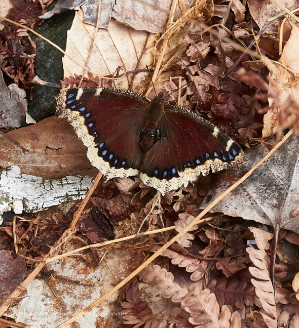
There are a few species of butterflies in our region that overwinter as adults. The mourning cloak is one of them. In order to tolerate freezing temperatures, the mourning cloak secrete glycogens—a natural anti-freeze—that allows them to tolerate temperatures down to -80 degrees! Since they’re already adults when the snow melts, they’re one of the first butterflies we see in spring.
Panasonic GM5, Lumix 12-32mm lens @ 32mm, ISO 400, f/8, 1/400″ exposure.
Sunday, May 6, 2018


Carolina spring beauties blooming in the woods
Morning Observation:
This morning in Huntington at 8:30AM it’s currently 63 degrees under partly cloudy skies. Winds are calm. Relative humidity is 57%, dewpoint 47, barometric pressure 29.99” and rising slowly. Yesterday’s high was 73, and the overnight low was 48.
Forecast:
A trough of low pressure over the Eastern Townships of Québec this morning and another trough approaching from the Great Lakes will drag a cold front across this region today bringing afternoon showers to much of the North Country along with cooler temperatures. The front will clear the region by tomorrow setting us up for some fine spring weather Tuesday into Wednesday. The next chance for showers arrives Thurdsday.
We’ll see partly cloudy skies this morning giving way to a few showers later in the day. Highs will be around 63F with WNW winds at 5 to 10 mph. Chance of rain is 30%. Tonight should bring showers early, then partly cloudy skies overnight. Lows will be around 41F with NNW winds at 5 to 10 mph. Chance of rain is 50%.
Monday should be mostly sunny with highs near 60F and NNW winds at 5 to 10 mph. Monday night should be mostly clear with lows near 40F and light and variable winds.
Tuesday’s looking mostly sunny with highs around 70F and light and variable winds. Tuesday night should be mostly clear with lows around 49F and light and variable winds.
Almanac:
Last year on this date we had a high of 69 and a low of 51. We picked up 0.46″ of rain.
Burlington averages for this date are a high of 64 and lows of 42.
The record high was 87°F in 1944.
The record low was 25°F in 1961.
Sky Notes:
Sunrise: 5:37AM
Sunset: 8:02PM
Length of Visible Light: 15h 30m
Length of Day: 14h 25m
Tomorrow will be 2 minutes 30 seconds longer
The Moon is waning gibbous, 20.6 days old with 66% illumination.
Moonrise: 1:07AM
Moonset: 10:41AM
About Today’s Photo:
Carolina spring beauties are in full bloom now. There’s a varitable carpet of these diminutive blossoms in certain places in the woods where I run in the mornings and they smell lovely!
Panasonic GM5, Lumix 12-32mm lens @ 32mm, ISO 400, f/8, 1/250″ exposure.
Saturday, May 5, 2018

Sharp lobed hepatica blooming in the woods
Morning Observation:
This morning in Huntington at 8:00AM it’s currently 49 degrees under partly cloudy skies. Winds are calm. Relative humidity is 72%, dewpoint 40, barometric pressure 29.95” and rising rapidly. We picked up 0.97” of rain yesterday evening when a real swashbuckler of a storm came through at around 8:00PM. We had a high wind gust of 32 mph. Quite a storm to watch develop! Yesterday’s high was 77, and the overnight low was 44.
Forecast:
We’ve got a lovely sunny spring day is on tap for today courtesy of high pressure building into the region this morning. A cold front moving through on Sunday will bring renewed showers in the afternoon along with cooler temperatures to start the upcoming week, but temperatures will rise throughout the week as high pressure builds back in.
Morning clouds will give way to generally sunny skies for this afternoon. Highs will be around 71F with west winds at 10 to 15 mph. Tonight should be partly cloudy this evening with more clouds building in overnight. Lows will be around 53F with SSW winds at 5 to 10 mph.
Sundasy should be cloudy with a few showers later in the day. Highs will be around 63F with west winds at 5 to 10 mph. Chance of rain is 30%. Sunday night should bring showers in the evening, then cloudy skies overnight. Lows will be around 39F with light and variable winds. Chance of rain is 40%.
Monday’s looking sunny and seasonably cool with highs around 56F and NNW winds at 5 to 10 mph. Monday night should be mostly clear with lows around 39F and light and variable winds.
Almanac:
Last year on this date we had a high of 51 and a low of 46. We picked up 0.01″ of rain.
Burlington averages for this date are a high of 64 and lows of 42.
The record high was 89°F in 1944.
The record low was 27°F in 1952.
Sky Notes:
Sunrise: 5:38AM
Sunset: 8:01PM
Length of Visible Light: 15h 27m
Length of Day: 14h 22m
Tomorrow will be 2 minutes 32 seconds longer
The Moon is waning gibbous, 19.7 days old with 75% illumination.
Moonrise: 12:22AM
Moonset: 9:48AM
About Today’s Photo:
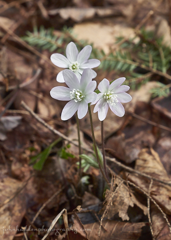
The spring ephemeral wildflowers are picking up steam in the woods finally. Sharp lobed hepatica is on of my favorites. These delicate white-with–a-pinkish-tinge flowers bloom in small groups in lime rich hardwood forests.
Panasonic GM5, Lumix 12-32mm lens @ 32mm, ISO 400, f/8, 1/200″ exposure.
Friday, May 4, 2018

A lovely set of willow buds
Morning Observation:
This morning in Huntington at 8:10AM it’s currently 58 degrees under mostly cloudy skies. Winds are calm. Relative humidity is 91%, dewpoint 56, barometric pressure 29.87” and steady. We picked up 0.14” of rain in the past 24hrs. Yesterday’s high was 74, and the overnight low was 56.
Forecast:
We’ve got an active weather day ahead of us. Low pressure moving out of the Great Lakes will lift a warm front through the region this morning and followed by a strong cold front this afternoon. Showers and thunderstorms will develop across the region this afternoon ahead and along the cold front. Some storms may be severe this afternoon, but any threat for severe weather will diminish after sunset. Following the front gusty winds will develop and may hit 40 to 55 mph across northern New York and southern Vermont. Winds will begin to taper off around sunrise on Saturday with a nice day on tap with clearing skies and seasonably warm temperatures. Another shot of rain is possible on Sunday but the upcoming week looks
to be dry.
We’ll see light rain developing this morning with thunderstorms by evening. Some storms may be severe. Highs will be around 72F with south winds at 10 to 20 mph. Chance of rain is 80%. Tonight thunderstorms are likely this evening with skies turning partly cloudy after midnight. Lows will be around 50F with WSW winds at 15 to 25 mph. Chance of rain is 80%. Winds could occasionally gust over 40 mph.
Saturday should bring a few clouds early then become mostly sunny. Highs will be around 69F with west winds at 10 to 20 mph. Saturday night should be partly cloudy with lows around 51F and SW winds at 5 to 10 mph.
Sunday’s looking mostly cloudy early with showers developing later in the day. Highs will be around 66F with SW winds at 5 to 10 mph. Chance of rain is 50%. Sunday night should be overcast with rain showers at times. It’ll be on the chilly side with lows around 38F and NNW winds at 5 to 10 mph. Chance of rain is 50%.
Almanac:
Last year on this date we had a high of 65 and a low of 30. We had a spot of frost.
Burlington averages for this date are a high of 63 and a low of 41.
The record high was 89°F in 1944.
The record low was 24°F in 1966.
Sky Notes:
Sunrise: 5:39AM
Sunset: 7:59PM
Length of Visible Light: 15h 24m
Length of Day: 14h 20m
Tomorrow will be 2 minutes 33 seconds longer.
The moon is waning gibbous, 18.8 days old with 82% illumination.
No Moonrise
Moonset: 8:59AM
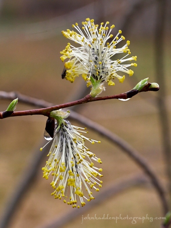
About Today’s Photo:
The willow buds that I photographed just peeking out a couple weeks ago are now in full “fireworks” mode. A touch of rain and a fly fill out the composition.
Panasonic GX8, Olympus 60mm macro lens, ISO 800, f/8, 1/500″ exposure.
Thursday, May 3, 2018

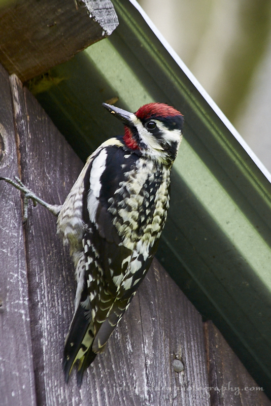
Our noisey friend, the yellow bellied sapsucker, is back
Morning Observation:
This morning in Huntington at 7:40AM it’s currently 59 degrees under overcast skies. Winds are calm. Relative humidity is 87%, dewpoint 55, barometric pressure 29.87” and steady. Yesterday’s high was 86, and the overnight low was 54.
Forecast:
We’ve got an active weather scene ahead of us for the next couple of days. Rainfall will move back into the North Country this morning as the first of several disturbances cross the region. Isolated to scattered thunderstorms will be possible today, especially across southern Vermont. More widespread
thunderstorm activity is expected Friday as a strong cold front crosses the region. There’s a chance that some of these storms may reach severe levels with accompanying gusty winds. Locally heavy rainfall will also be possible during these storms with most areas picking up between 0.50″-1″ through Friday. High pressure will build back in on Saturday bringing to return to drier conditions, although there’s a chance of rain on Sunday.
We’ll see rain showers early developing into a more steady rain for the afternoon. Highs will be near 70F with SW winds at 5 to 10 mph. Chance of rain is 70% with rainfall near 0.25″. Tonight should bring a steady rain this evening with showers continuing overnight. Lows will be around 58F with light and variable winds. Chance of rain is 90% with rainfall near 0.25″.
Friday should bring scattered thunderstorms in the morning, then mostly cloudy skies during the afternoon with thunderstorms likely. A few storms may be severe. Highs will be around 70F with SSW winds at 10 to 20 mph. Chance of rain is 80%. Friday night should bring showers in the evening, then partly cloudy skies overnight. Lows will be around 49F with WSW winds at 15 to 25 mph. Chance of rain is 50%.
Saturday’s looking partly cloudy with highs around 70F and west winds at 10 to 15 mph. Saturday night should be partly cloudy during the evening, giving way to cloudy skies overnight. Lows will be around 49F with light and variable winds.
Almanac:
Last year on this date we had a high of 49 and a low of 33. We picked up 0.23″ of rain.
Burlington averages for this date are a high of 63 and lows of 41.
The record high was 89°F in 2001 (we had a high of 86). Burlington set a new record high yesterday of 88, up from 86 in 2001).
The record low was 24°F in 1966.
Sky Notes:
5:41 AM 7:58 PM
Length of Visible Light: 15h 21m
Length of Day: 14h 17m
Tomorrow will be 2 minutes 35 seconds longer
The Moon is waning gibbous, 17.9 days old with 89% illumination.
Moonrise: 11:33PM
Moonset: 8:15AM
About Today’s Photo:
Who’s that tap-tap-tapping? Who’s that tap-tap-tapping on the metal roof of our woodshed at 5:30AM right outside our bedroom window? Why it’s Mr. Yellow Bellied Sapsucker, that’s who! We hope he finds a mate soon so he’ll stop his tap-tap-tapping…
Wednesday, May 2, 2018

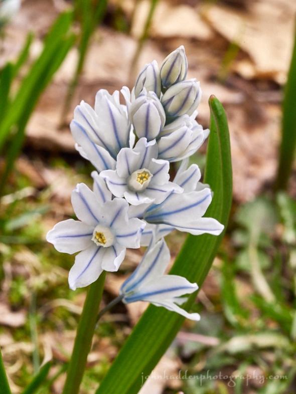
Another bloom of volunteer flowers in our back yard. Can anyone identify these?
Morning Observation:
This morning in Huntington at 7:30AM it’s a balmy 58 degrees under mostly clear skies. Winds are light out of the south at 0-3 mph. Relative humidity is 59%, dewpoint 44, barometric pressure 29.93” and steady. We picked up 0.02” of rain in the past 24hrs. Yesterday’s high was 68, and the overnight low was 44.
Forecast:
Break out the t-shirt, shorts, and flip-flops folks, ’cause it’s gunna be a lovely day today!
High pressure cresting over the region this morning will bring gusty winds and unseasonably warm temperatures today with a slight chance of a stray shower or thunderstorm across northern counties toward evening. The threat of showers and embedded thunderstorms will increase for Thursday into Friday as a series of disturbances move across the region. Locally heavy rainfall and gusty winds will be possible with a few of the storms, especially across southern Vermont on Friday. Dry conditions and seasonable temperatures look to be in store for us going into the weekend.
We’ll see partly cloudy skies today with a stray shower or thunderstorm possible this afternoon. Highs will top out near 81F with SW winds at 10 to 20 mph. Tonight should be cloudy with a stray shower or thunderstorm possible. Lows will be around 61F with SW winds at 10 to 15 mph.
Thursday should be cloudy with showers. Highs will be near 70F with WSW winds at 5 to 10 mph. Chance of rain is 50%. Thursday night should bring rain early with cloudy skies and scatterd showers late. Lows will be around 60F with WSW winds at 5 to 10 mph. Chance of rain is 80% with rainfall around 0.25″-0.50″.
Friday should bring howers early then thundershowers developing later in the day. Highs will be around 70F with SSW winds at 10 to 20 mph. Chance of rain is 90%. Friday night should bring thunderstorms in the evening giving way to cloudy skies overnight. Lows will be around 49F with WSW winds at 10 to 20 mph. Chance of rain is 90%.
Almanac:
Last year on this date we had a high of 62 and a low of 45.
Burlington averages for this date are a high of 63 and lows of 41.
The record high was 86°F in 2001 (we had a high of 86).
The record low was 27°F in 1966.
Sky Notes:
Sunrise: 5:42AM
Sunset: 7:57PM
Length of Visible Light: 15h 19m
Length of Day: 14h 15m
Tomorrow will be 2 minutes 37 seconds longer
The Moon is waning gibbous, 17 days old with 95% illumination.
Moonrise: 10:37PM
Moonset: 7:35AM
About Today’s Photo:
Along with the glory-of-the-snow blooms I posted yesterday, we have a few of these lovely flowers blooming in the backyard. Can anyone identify them for me?
Panasonic GX8, Olympus 60mm macro lens, ISO 1600, f/14, 1/125″ exposure.
Tuesday, May 1, 2018

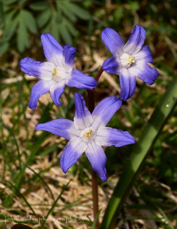
Glory of the snow blooming in our back yard.
Rabbit-rabbit!
Morning Observation:
This morning in Huntington at 7:40AM it’s currently 44 degrees under overcast skies. Winds are calm. Relative humidity is 98%, dewpoint 43, barometric pressure 30.02“ and steady. We picked up 0.18” of rain in the past 24hrs. Yesterday’s high was 46, and the overnight low was 43.
Forecast:
High pressure will build into the region today into tomorrow bringing fair weather and much warmer temperatures. We may bump into the low 80s tomorrow so break out the the shorts, t-shirts, and flip-flops! The dry weather will be short lived, however, as rounds of showers and a few thunderstorms will return for Thursday into Friday. At this point mainly fair conditions look to be on tap for the upcoming weekend.
We’ll see cloudy skies and a slight chance of a rain shower this morning giving way to partly sunny skies this afternoon. Highs will be around 66F with light and variable winds. Tonight should be partly cloudy with lows near 55F and SSW winds at 10 to 15 mph.
Wednesday should be partly cloudy early, becoming cloudy later in the day with a stray shower or thunderstorm possible. Highs will be near 80F with SW winds at 10 to 20 mph. Wednesday night should bring scattered thunderstorms overnight. Lows will be around 61F with SW winds at 10 to 15 mph. Chance of rain is 50%.
Thursday showers and thunderstorms are likely. Highs will be near 70F with SW winds at 10 to 15 mph. Chance of rain is 90%. Thursday night should be mostly cloudy with occasional rain mainly in the evening with thunder possible early. Lows will be around 54F with WNW winds at 5 to 10 mph. Chance of rain is 90%.
Almanac:
Last year on this date we had a high of 72 and a low of 50. We picked up 0.25″ of rain.
Burlington averages for this date are a high of 62 and a low of 41.
The record high was 86°F in 2001 (we had a high of 84).
The record low was 25°F in 1961.
Sky Notes:
Sunrise: 5:43AM
Sunset: 7:56PM
Length of Visible Light: 15h 16m
Length of Day: 14h 12m
Tomorrow will be 2 minutes 38 seconds longer
The Moon is waning gibbous, 16 days old with 98% illumination.
Moonrise: 9:39PM
Moonset: 6:59AM
About Today’s Photo:
The previous owners of our home planted glory-of-the-snow (chionodoxa) bulbs somewhere in the back yard some 34 years ago, and now they pop up every spring in all kinds of places. These pretty flowers seem to have naturalized here, and they’re some of the earliest cultivars that we see.
Panasonic GX8, Olympus 60mm macro lens, ISO 1600, f/14, 1/1300″ exposure.
