Tuesday, October 31, 2017


A peel of fallen white pines on Delfrate Road
Morning Observation:
This morning in Huntington at 7:30AM it’s currently 44 degrees and blustery under partly cloudy skies. Winds are out of the south at 5-10 mph. Relative humidity is 69%, dewpoint 34, barometric pressure 29.79” and rising rapidly. We picked up 0.05” of rain in the past 24hrs. Yesterday’s high was 65, and the overnight low was 43. Still no power here…
Forecast:
The deep low pressure system that brought damaging winds and rain over the last 36 hours is now centered over James Bay. It will rotate a weak trough through the region tonight kicking off a few scattered showers. High pressure will build in Wednesday before the next round of more organized showers arrive Wednesday night into Thursday. Temperatures will remain on the cool side of seasonable through Wedneday before a warming trend arrives Friday.
We’ll see a mix of clouds and sun this morning followed by mostly cloudy skies and a few showers this afternoon. Highs will be around 48F with SW winds at 10 to 20 mph. Chance of rain is 30%. Tonight should be partly cloudy with low around 32F and SW winds at 5 to 10 mph.
Wednesday should be cloudy with highs around 47F and south winds at 5 to 10 mph. Wednesday night should bring rain showers in the evening, becoming a steady light rain overnight. Lows will be around 41F with SSE winds at 5 to 10 mph. Chance of rain is 70%.
Thursday’s looking cloudy with periods of light rain. Highs will be around 61F with south winds at 10 to 20 mph. Chance of rain is 70%. Thursday night should be cloudy with occasional rain showers and some rumbles of thunder possible. Lows will be around 55F with SSW winds at 10 to 20 mph. Chance of rain is 80%.
Almanac:
Last year on this date we had a high of 39 and a low of 29. We picked up 0.06″ of rain.
Burlington averages for this date are highs of 52 and lows of 35.
The record high was 69°F in 1946.
The record low was 17°F in 1925.
Sky Notes:
Sunrise: 7:29AM
Sunset: 5:44PM
Length of Visible Light: 11h 15m
Length of Day: 10h 15m
Tomorrow will be 2 minutes 43 seconds shorter
The Moon is waxing gibbous, 10.6 days old with 81% illumination.
Moonrise: 4:13PM
Moonset: 2:58AM
About Today’s Photo:
As I’m sure most of you are aware, the strong winds caused extensive tree damage around the region. This “peel” of 80′ white pines at the bottom of Delfrate Road is a case in point. I’m always astounded how such tall trees can be anchored by almost nothing, with root systems that spread out laterally instead of sinking into the earth.
Panasonic GX8, Lumix 14-140mm lens @ 14mm, ISO 800, f/11, 1/100″ exposure
Monday, October 30, 2017


Can you figure out what this is?
Morning Observation:
Well that was a wild and wooly night!
This morning in Huntington at 8:00AM it’s currently 54 degrees under mostly cloudy skies. Winds are out of the south at 0-3 mph. Relative humidity is 91%, dewpoint 51, barometric pressure 28.95” and rising. We picked up 1.14” of rain in the past 24hrs, and had a max wind gust here of 45 mph (not quite our top gust of 52mph, but pretty strong for our protected hollow…) and our power is currently out. Yesterday’s high was 62, and the overnight low was 54.
Forecast:
The near-record low pressure that delivered last night’s damaging winds is slowing moving north of the region this morning. We’ll continue to see showers today and a renewed chance of gusty winds. Cool air will move in behind the departing low tonight into Tuesday bringing the chance of some snowfall on mountain summits overnight. Wednesday should be seasonably cool with more unsettled weather arriving towards the weekend.
We’ll see mostly cloudy skies today. It’ll be windy with periods of rain. Highs will be near 55F with SW winds at 25 to 35 mph. Chance of rain is 80%, and winds could occasionally gust over 40 mph. Tonight should be partly cloudy with gusty winds during the evening and a shower of rain or wet snow possible at high eleveations. Lows will be around 40F with SW winds at 20 to 30 mph.
Tuesday should be partly sunny with a shower of rain or wet snow possible early. Highs will be around 50F with SW winds at 15 to 25 mph. Tuesday night should be partly clouyd with lows around 35F and SW winds at 5 to 10 mph.
Wednesday’s looking cloudy with highs around 50F and south winds at 5 to 10 mph. Wednesday night should be cloudy in the evening with off and on rain showers after midnight. Lows will be around 40F with SSE winds at 5 to 10 mph. Chance of rain is 40%.
Almanac:
Last year on this date we had a high of 48 and a low of 37. We picked up 0.40″ of rain.
Burlington averages for this date are highs of 52 and lows of 35.
The record high was 70°F in 1935.
The record low was 20°F in 1925.
Sky Notes:
Sunrise: 7:27AM
Sunset: 5:45PM
Length of Visible Light: 11h 18m
Length of Day: 10h 17m
Tomorrow will be 2 minutes 45 seconds shorter
The Moon is waxing gibbous, 9.6 days old with 73% illumination.
Moonrise: 3:43PM
Moonset: 1:53AM
About Today’s Photo:
I came across this interesting object while helping to clear a new trail up at Camel’s Hump Nordic over the weekend. It was easy to figure out what it was standing in the woods, but a bit more of a challenge in a photo. A small birch log had basically “deflated” on the ground, rotting from the inside out and leaving behind only its curled and mottled bark.
Panasonic GX8, Lumix 14-140mm lens @ 24mm, ISO 800, f/8, 1/100″ exposure.
Sunday, October 29, 2017


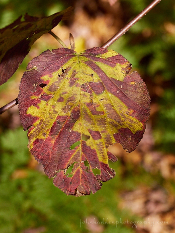
Red oak leaves “rusting” in our front yard
Morning Observation:
This morning in Huntington at 9:30AM (late night…) it’s currently 57 degrees and raining lightly under overcast skies. Winds are calm. Relative humidity is 93%, dewpoint 55, barometric pressure 29.80” and falling slowly. We picked up 0.05” of rain so far. Yesterday’s high was 66, and the overnight low was 54.
There is currently a High Wind Warning in effect for our region from 8:00PM this evening to 11:00AM Monday.
Forecast:
We’re on track for some soaking rain and high winds. A cold front and associated low pressure system have moved into the region overnight and will stall over the region allowing a second area of tropical-moisture-laden low pressure to move northward along the front. Combined, these will bring high winds and periods of rain through Monday. The greatest threat will be strong and potentially damaging wind gusts along the western slopes of the Greens and parts of the Northeast Kingdom on Sunday Night, followed by another round of gusty winds over northern New York and parts of Vermont on Monday afternoon on the backside of the departing low. Some power outages are possible. Rainfall will cause rises on streams and rivers with near 2″ expected in the Champlain Valley and up to 4″ in the ‘Dacks.
We’ll see cloudy skies today with periods of rain and windy conditions for the afternoon. Highs will be around 61F with SE winds at 20 to 30 mph. Chance of rain is 100% with rainfall amounts near a half an inch and locally heavier rainfall possible. Tonight will be windy with periods of rain. Lows will be around 58F with ESE winds at 25 to 35 mph. Chance of rain is 100% with rainfall amounts of 1″ and locally heavier rainfall possible.
Monday should be cloudy and windy with periods of rain. Morning highs will be around 61F with temperatures falling to near 50 during the day. Winds will be out of the SSW at 25 to 35 mph. Chance of rain is 90% with rainfall amounts near a half an inch. Winds could occasionally gust to over 40 mph. Monday night should be partly cloudy skies with gusty winds early and showers of rain or wet snow possible at across the mountains summits. Lows will be around 40F with SW wind at 20 to 30 mph.
Tuesday’s looking partly cloudy in the morning giving way to cloudy skies during the afternoon with a shower of rain or wet snow possible again along mountain summits. High will be near 50F with winds SW at 15 to 25 mph. Tuesday night should be partly cloudy with lows near 35F and SW winds at 5 to 10 mph.
Almanac:
Last year on this date we had a high of 48 an a low of 37. We picked up 0.19″ of rain.
Burlington averages for this date are highs of 52 and lows around 35.
The record high was 71°F in 1946.
The record low was 20°F in 1969.
Sky Notes:
Sunrise: 7:26AM
Sunset: 5:47PM
Length of Visible Light: 11h 20m
Length of Day: 10h 20m
Tomorrow will be 2 minutes 46 seconds shorter
The Moon is waxing gibbous, 8.7 days old with 64% illumination.
Moonrise: 3:11PM
Moonset: 12:51AM
About Today’s Photo:
Many years ago, Robin pulled a red oak sapling out of the woods and planted it at the edge of our front yard. It’s now about 25′ tall and one of the showcase trees on our property (despite being decapitated in 2014…) This time of year it’s leaves look like they’re rusting…
Panasonic GX8, Lumix 14-140mm lens @ 61mm, ISO 800, f/5.2, 1/2000″ exposure
Saturday, October 28, 2017


Bright yellow Amur cork leaves poised to drop
Morning Observation:
This morning in Huntington at 7:35AM it’s currently 42 degrees under clear skies. Winds are calm. Relative humidity is 89%, dewpoint 39, barometric pressure 29.97” and falling. Yesterday’s high was 57, and the overnight low was 41.
Forecast:
The calm before the storm… A dry and warm day is expected today with rainy and breezy conditions developing on Sunday into Monday. As discussed yesterday, strong low pressure moving east from the Great Lake this morning will join forces with a tropical moisture laden low moving up the Atlantic coast. This will deliver periods of moderate to heavy rainfall which will cause sharp rises on local streams and rivers with some rivers approaching flood stage by Monday. (Flood watches have been posted for the Adirondacks and areas in eastern Vermont, though the forecasters have dialed back on the “record rainfall” language…) Breezy southeast winds are possible ahead of the system on Sunday with gusty westerly winds on the backside anticipated for Monday. Drier and cooler weather will return by Tuesday of next week.
We’ll see sunny to partly cloudy skies today with highs around 67F and south wind at 10 to 20 mph. Tonight should be partly cloudy early followed by cloudy skies overnight. Lows will be around 54F with SSE at 5 to 10 mph.
Sunday will bring showers early, becoming a steady rain later in the day. Highs will be around 62F with SE at 10 to 20 mph. Chance of rain is 90% with rainfall around a half an inch with some locally heavy rainfall possible. Sunday night should be windy with rain early, then remaining cloudy with thundershowers late. Lows will be near 55F with ESE at 25 to 35 mph. Chance of rain is 100% with rainfall near 1″ and locally heavier rainfall possible.
Monday should be cloudy and windy with rain in the morning, then becoming partly cloudy later in the day. Highs will be around 58F with SW at 20 to 30 mph. Chance of rain is 90% with rainfall around a quarter of an inch. Winds could occasionally gust to over 40 mph. Monday night should be cloudy early, followed by partial clearing. Lows will be around 41F with SW winds at 10 to 20 mph.
Almanac:
Last year on this date we had a high of 42 and a low of 38. We picked up 0.61″ of rain.
Burlington averages for this date are highs of 53 and lows of 36.
The record high was 75°F in 1947.
The record low was 19°F in 1974.
Sky Notes:
Sunrise: 7:25AM
Sunset: 5:48PM
Length of Visible Light 11 h 23 m
Length of Day 10 h 23 m
Tomorrow will be 2 minutes 47 seconds shorter
The moon is waxing gibbous, 7.7 days od with 53% illumination.
Moonrise: 2:37PM
No moonset
About Today’s Photo:
Decades ago, I planted a small Amur cork tree next to our ornamental garden (then our vegetable garden…) Now, the tree stands 30′ tall and is one of the showiest of our trees this time of year. On years when the first hard freeze is late, the leaves turn a brilliant yellow as they have this season. When the freeze comes, however, the leaves “abandon ship” all at once to shower down in a thick carpet on the ground. With no hard freezes in the immediate forecast, we might have these leaves around for a bit more.
Panasonic GX8, Lumix 14-140mm lens @ 46mm, ISO 800, f/4.9, 1/4000″ exposure.
Friday, October 27, 2017

Hobble-bush takes on its fall colors
Morning Observation:
This morning in Huntington at 7:30AM it’s currently 40 degrees under partly cloudy skies. Winds are calm. Relative humidity is 96%, dewpoint 39, barometric pressure 29.93” and rising rapidly. We picked up 1.29” of rain in the past 24hrs (1.49” for the storm). Yesterday’s high was 51, and the overnight low was 40.
Forecast:
High pressure will build in today into Saturday bringing fair weather and moderating temperatures. Strong low pressure moving north out of the tropics will ride up a stalling cold front Saturday night and combine with another more powerful low moving out the the Great Lakes. This will set the stage for rounds of moderate to potentially torrential rainfall and gusty winds for Sunday into the first half of Monday. We might see some rainfall records set. Behind this system variably cloudy skies along with a few showers will be possible into early next week as temperatures average near late October norms.
We’ll see a mix of clouds and sun today with highs near 55F and SW winds at 5 to 10 mph. Tonight should be mainly clear with lows around 44F and south winds at 5 to 10 mph.
Saturday should be mostly sunny with highs around 67F and south winds at 10 to 20 mph. Saturday night should start out partly cloudy skies early,giving way to cloudy skies and rain during the night. Lows will be near 55F with SE winds at 5 to 10 mph. Chance of rain is 70%.
Sunday will bring widespread rain. Highs will be around 60F with SE winds at 10 to 20 mph. Chance of rain is 100% with 1″ to 2″ of rain expected. Rain will continue into Sunday night with the potential for heavy rainfall. Lows will be near 50F with NE winds at 10 to 20 mph. Chance of rain is 100% with 1″ to 2″ of rain expected—that’s 2″ to 4″ for this storm. A juicy one…
Almanac:
Last year on this date we had a high of 39 and a low of 26. We picked up 0.05″ of rain.
Burlington averages for this date are highs of 53 and lows of 36.
The record high was 74°F in 1947.
The record low was 22°F in 1974.
Sky Notes:
Sunrise: 7:23AM
Sunset: 5:50PM
Length of Visible Light: 11h 26m
Length of Day: 10h 26m
Tomorrow will be 2 minutes 48 seconds shorter
Moon is in its first quarter, 6.8 days old with 44% illumination.
Moonrise: 1:59PM
Moonset: 11:52PM
About Today’s Photo:
Hobble-buch (Viburnum lantanoides) up in the woods at Camel’s Hump Nordic is showing its mottled fall burst of color and intersting patterns.
Panasonic GX8, Lumix 14-140mm lens @ 55mm, ISO 800, f/5.1, 1/2000″ exposure.
Thursday, October 26, 2017
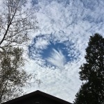
A fallstreak hole above our house
Morning Observation:
This morning in Huntington at 7:20AM it’s currently 46 degrees and raining lightly under overcast skies. Winds are calm. Relative humidity is 95%, dewpoint 44, barometric pressure 29.74” and steady. We picked up 0.20” of rain overnight. Yesterday’s high was 65, and the overnight low was 46.
Forecast:
A slow moving area of low pressure centered over Cape Cod this morning will track northward through eastern New England today and into this evening bringing widespread light to moderate rain from the eastern Adirondacks east into Vermont. High pressure and fair conditions return for Friday into Saturday as
temperatures moderate to seasonably mild levels. Strengthening low pressure over the Great Lakes will bring a renewed threat of rain to the region on Sunday into Monday, which could fall heavily at times.
We’ll see cloudy skies today with periods of rain. Highs will be around 48F with NNW winds at 5 to 10 mph. Chance of rain is 100% with rainfall amounts near a half an inch. Tonight should be cloudy with occasional rain mainly this evening. Lows will be near 40F with WNW winds at 10 to 15 mph. Chance of rain is 90%.
Friday should be partly cloudy with highs near 55F and WSW winds at 5 to 10 mph. Friday night should be partly cloudy with lows around 43F and light and variable winds.
Saturday’s looking partly cloudy with highs around 67F and SSE at 10 to 15 mph. Saturday night should be partly cloudy early giving way to a few showers after midnight. Lows will be around 54F with SSE winds at 5 to 10 mph. Chance of rain is 30%.
Almanac:
Last year on this date we had a high of 36 and a low of 33.
Burlington averages for this date are highs of 53 and lows of 36.
The record high was 75°F in 1963.
The record low was 19°F in 1941.
Sky Notes:
Sunrise: 7:22AM
Sunset: 5:51PM
Length of Visible Light: 11h 28m
Length of Day: 10h 29m
Tomorrow will be 2 minutes 49 seconds shorter
The Moon is a waxing crescent, 6 days old with 35% illumination.
Moonrise: 1:18PM
Moonset: 10:56PM
About Today’s Photo:
Last Sunday, a friend called the house and asked if we see the “hole” in the clouds. I was up in the woods so I missed it, but Robin managed to snap this shot of it. After a bit of research (and some direction from Steve Bower and confirmation from Eye-on-the-Sky guy, Steve Maleski) we learned that this is a “fallstreak hole”. To quote Steve Maleski:
“I’m almost certain that what happened is that as a jet either ascended or descended through that altocumulus layer, its exhaust seeded the supercooled water droplets composing the clouds. As rapid conversion to ice crystals occurred in the seeded area, they grew at the expense of surrounding supercooled droplets, so those droplets evaporated and a growing hole appeared in the cloud deck. The moisture then migrated to the growing ice crystals; the ice-crystals grew to snowflake size and started falling as snow. The snow shaft then evaporated in a sub-cloud dry layer, producing the virga, or fall-streak. Pretty cool!”
Pretty cool indeed!
iPhone SE, photo credit: Robin Hadden
Wednesday, October 25, 2017


The Korean mountain ash in our front yard in russet sunset light
Morning Observation:
This morning in Huntington at 8:30AM it’s currently 58 degrees under mostly cloudy skies. Winds are calm. Relative humidity is 98%, dewpoint 58, barometric pressure 29.66”. We picked up 0.46” of rain in the past 24hrs. Yesterday’s high was 74, and the overnight low was 56.
Forecast:
The front and associated trough that brought yesterday’s showers has moved to our east this morning. We’ll see generally dry and mild conditions today. The flow aloft will allow the trough to back into the region again tomorrow into Friday bringing renewed showers through that period. Temperatures will return to seasonal normals tomorrow and going into the weekend.
We’ll see mostly cloudy skies today with a slight chance of shower along the Connecticut River valley. Highs will be around 64F with SSW winds at 5 to 10 mph. Tonight should bring scattered showers early becoming a steady light rain overnight. Lows will be near 45F with light and variable winds. Chance of rain is 70%.
Thursdady rain is likely. Highs will be around 49F with NNW winds at 5 to 10 mph. Chance of rain is 100% with rainfall around a half an inch. Thursday night should see a steady rain into the evening with showers continuing late. Lows will be around 42F with WNW winds at 10 to 15 mph. Chance of rain is 80%. Rainfall around a quarter of an inch.
Friday should be generally sunny with highs around 54F and west winds at 10 to 15 mph. Friday night should be partly cloudy with lows around 41F and light and variable winds.
Almanac:
Last year on this date we had a high of 39 and a low of 34.
Burlington averages for this date are highs of 54 and lows of 36.
The record high was 80°F in 1963.
The record low was 22°F in 1949.
Sky Notes:
Sunrise: 7:21AM
Sunset: 5:53PM
Length of Visible Light: 11h 31m
Length of Day: 10h 31m
Tomorrow will be 2 minutes 50 seconds shorter
The Moon is a waxing crescent, 5 days old with 26% illumination.
Moonrise: 12:32PM
Moonset: 10:05PM
About Today’s Photo:
The Korean mountain ash in our front yard is one of the later trees to turn and drop its leaves. It’s set a bountiful crop of berries this time around—welcome food for a variety of birds through the fall and winter.
Panasonic GX8, Lumix 14-140mm lens @ 73mm, ISO 1600, f/5.6, 1/125″ exposure.
Tuesday, October 24, 2017

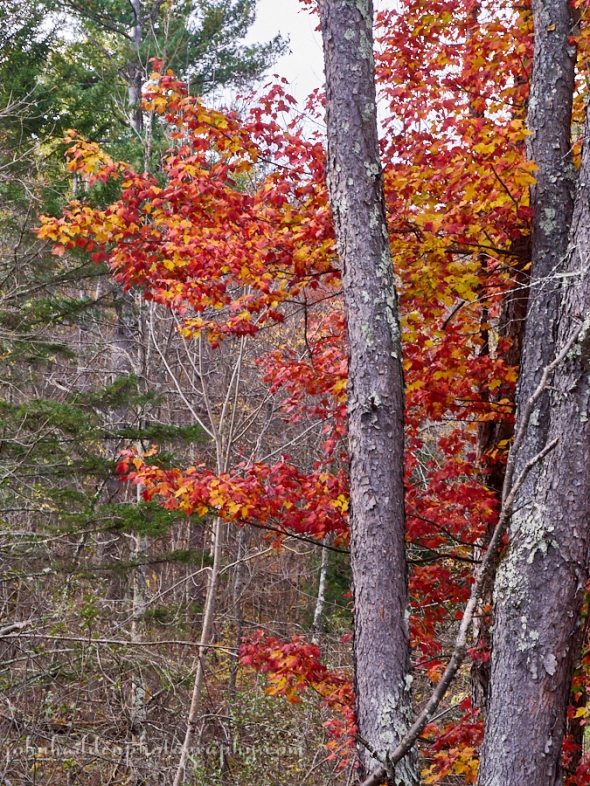
Our last bright maple
Morning Observation:
This morning in Huntington at 7:40AM it’s currently a blustery and balmy 67 degrees under mostly cloudy skies. Winds are out of the south at 5-10 mph, gusting to 24 mph. Relative humidity is 77%, dewpoint 60, barometric pressure 29.80” and falling slowly. Yesterday’s high was 72, and the overnight low was 64.
Forecast:
A change in the weather has finally arrived. Deep low pressure over the western Great Lakes this morning will pull moisture laden air through the region over the next 48 hours. We’ll see periods of moderate to heavy rain across northern New York this morning and afternoon and then late this afternoon and tonight across Vermont. Many locations across the area will see wind gusts in the 35 to 45 mph range with isolated gusts to 50 mph. Winds and rain will taper off later tonight but linger into Wednesday morning. Expect 1″-2″ of total rainfall. Above normal temperatures are expected today as well as Wednesday before more October-like conditions arrive later in the week.
We’ll see clouds and wind during the morning with rain becoming likely later this afternoon. A rumble or two of thunder is possible. Highs will be around 70F with SSE winds at 20 to 30 mph. Chance of rain is 90%. Tonight should bring some thunder along with showers overnight. Lows will be near 55F with south winds at 15 to 25 mph. Chance of rain is 100%.
Wednesday should be cloudy early, becoming partly cloudy later in the day with a slight chance of a rain showers. Highs will be around 63F with SSW winds at 5 to 10 mph. Wednesday night should be cloudy with occasional showers late at night. Lows will be around 43F with light and variable winds. Chance of rain is 50%.
Thursday should bring more showers. Highs will be around 51F with NNW at 5 to 10 mph. Chance of rain is 80%. Thursday night should bring rain showers early with mostly clear conditions later at night. Lows will be around 38F with west winds at 5 to 10 mph. Chance of rain is 60%.
Almanac:
Last year on this date we had a high of 49 and a low of 38. We picked up 0.02″ of rain.
Burlington averages for this date are highs of 54 and lows of 37.
The record high was 75°F in 1963.
The record low was 21°F in 1969.
Sky Notes:
Sunrise: 7:19AM
Sunset: 5:54PM
Length of Visible Light: 11h 34m
Length of Day: 10h 34m
Tomorrow will be 2 minutes 51 seconds shorter
The Moon is a waxing crescent, 4.2 days old with 18% illumination.
Moonrise: 11:42AM
Moonset: 9:18PM
About Today’s Photo:
There’s a particular maple tree in our back yard next to Fargo Brook that turns a brilliant red-orange every fall. It did not disappoint this season. It’s one of the last maples to hold its color, and even after last night’s winds, it’s still hanging in there. Methinks that today’s strong winds will move us rapidly into stick season…
Panasonic GX8, Lumix 14-140mm lens @ 55mm, ISO 800, f/14, 1/60″ exposure.
Monday, October 23, 2017


A fading wood fern along the trail at CHN
Morning Observation:
This morning in Huntington at 7:55AM it’s currently 47 degrees under partly cloudy skies. Winds are calm. Relative humidity is 84%, dewpoint 43, barometric pressure 30.24”. Yesterday’s high was 77, and the overnight low was 47.
Forecast:
We’ve got one more day of dry weather and above normal temperatures on tap for today. Low pressure sitting over the western Great Lakes will then begin to spin deep moisture from south to north across the area tonight with a few showers possible over northern New York and southern Vermont tonight. Eventually rain will become widespread over the region Tuesday and Tuesday night and will be heavy at times. The rain will end from west to east during the morning hours on Wednesday. We should see total rainfall in the 1″ to 2″ range over much of the area.
We’ll see partly cloudy skies today with highs around 71F and south winds at 10 to 20 mph. Tonight should be partly cloudy then become mostly cloudy after midnight with a slight chance of a shower. Lows will be around 63F with SE at 10 to 20 mph.
Tuesday should be cloudy in the morning hours followed by thunderstorms and widespread rain in the afternoon. Highs will be around 71F with SSE at 15 to 25 mph. Chance of rain is 80% with winds occasionally gusting over 40 mph. Rain will continue into Tuesday night with some rumbles of thunder possible. Lows will be around 57F with south winds at 10 to 20 mph. Chance of rain is near 100% with 1″ to 2″ of rain expected.
Wednesday will bring showers in the morning, then partly cloudy skies in the afternoon. Highs will be around 62F with south winds at 5 to 10 mph. Chance of rain is 40%. Wednesday night should be partly cloudy with lows around 44F and light and variable winds.
Almanac:
Last year on this date we had a high of 49 and s low of 33. We picked up 1.11″ of rain and 1.5″ of snow.
Burlington averages for this date are highs of 54 and lows of 37.
The record high was 78°F in 1979.
The record low was 20°F in 1961.
Sky Notes:
Sunrise: 7:18AM
Sunset: 5:56PM
Length of Visible Light: 11h 36m
Length of Day: 10h 37m
Tomorrow will be 2 minutes 52 seconds shorter
The Moon is a waxing crescent, 3.3 days old with 12% illumination.
Moonrise: 10:47AM
Moonset: 8:35PM
About Today’s Photo:
Along with the leaves on the trees, ferns are also changing color this time of year. Wood ferns—common in the, uh, woods—are beginning to drain of their color as the green chlorphyll breaks down. They will fade to yellow, then near paper white before the snow flies.
Panasonic GX8, Lumix 14-140mm lens @ 46mm, ISO 800, f/10, 1/400″ exposure.
Sunday, October 22, 2017


Beech leaves turning gold up in the high hills
Morning Observation:
This morning in Huntington at 7:15AM it’s currently 41 degrees under mostly clear skies. Winds are calm. Relative humidity is 97%, dewpoint 40, barometric pressure 30.36” and rising slowly. Yesterday’s high was 74, and the overnight low was 41.
Forecast:
Our extended Indian Summer will continue for a couple more days as high pressure remains over the region. Expect above normal temperatures and dry conditions today and Monday. A large upper level trough of low pressure will approach Monday night and move across the region Tuesday into Wednesday bringing clouds and a fairly widespread rain Tuesday into Wednesday
We’ll see partly cloudy skies today with highs around 76F and SSE at 5 to 10 mph. Tonight should be partly cloudy with areas of dense fog developing. Lows wil be around 53F with SSE at 5 to 10 mph.
Monday should be mostly sunny with highs around 71F and south winds at 10 to 15 mph. Monday night should be partly cloudy early, becoming overcast later during the night with a slight chance of showers. Lows will be around 63F with SSE winds at 10 to 20 mph.
Tuesday’s looking cloudy with occasional rain in the afternoon. Highs will be around 71F with SSE winds at 15 to 25 mph. Chance of rain is 80% with rainfall amounts near a quarter of an inch. Tuesday night will bring periods of rain with some rumbles of thunder possible. Lows will be around 56F with south winds at 10 to 15 mph. Chance of rain is 100%.
Almanac:
Last year on this date we had a high of 47 and a low of 33. We picked up 0.78″ of rain.
Burlington averages for this date are highs of 55 and lows of 37.
The record high was 81°F in 1979.
The record low was 23°F in 1959.
Sky Notes:
Sunrise: 7:17AM
Sunset: 5:57PM
Length of Visible Light: 11h 39m
Length of Day: 10h 40m
Tomorrow will be 2 minutes 53 seconds shorter
The Moon is a waxing crescent, 2.3 days old with 6% illumination.
Moonrise: 9:50AM
Moonset: 7:58PM
About Today’s Photo:
I was helping out on the Camel’s Hump Nordic trail crew yesterday morning. We were working on a new trail up at around 1500′ and many of the maples had already dropped their leaves. The beeches, however, were in fine fall form with their leaves shifting through lime green, to gold, to russet.
Panasonic GX8, Lumix 14-140mm lens @ 65mm, ISO 800, f/13, 1/500″ exposure.
Saturday, October 21, 2017

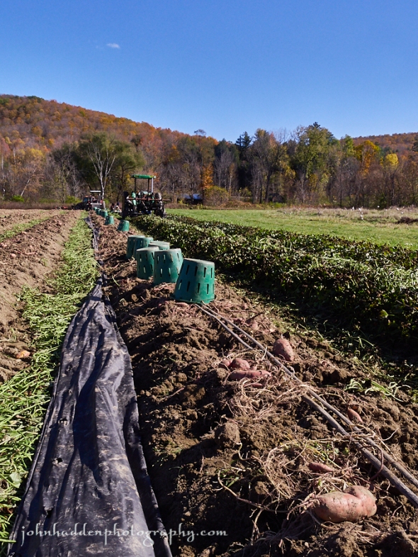
Harvesting sweet potatoes in the Hanson field in the Lower Village
Morning Observation:
This morning in Huntington at 7:35AM it’s currently 39 degrees under clear skies. Winds are calm. Relative humidity is 96%, dewpoint 38, barometric pressure 30.24” and rising. Yesterday’s high was 65, and the overnight low was 38.
Forecast:
Our extended Indian Summer continues courtesy of a large area of high pressure over much of the eastern US. Dry and above average temperatures will be the rule through the middle of next week when low pressure finally brings some much needed rain.
We’ll see mostly sunny skies today with a few afternoon clouds. Highs will be around 72F with light and variable winds. Tonight should be partly cloudy with lows around 51F and light and variable winds.
Sunday should be partly cloudy with highs near 75F and S at 5 to 10 mph. Sunday night should be partly cloudy with lows around 54F and south winds at 5 to 10 mph.
Monday’s loooking partly sunny with highs around 70F and south at 10 to 15 mph. Monday night should be partly to mostly cloudy with lows around 61F and south winds at 5 to 10 mph.
Almanac:
Last year on this date we had a high of 75 and a low of 47. We picked up 0.11″ of rain.
Burlington averages for this date are highs of 55 and lows of 37.
The record high was 76°F in 1995.
The record low was 20°F in 1972.
Sky Notes:
Sunrise: 7:15AM
Sunset: 5:59PM
Length of Visible Light: 11h 42m
Length of Day: 10h 43m
Tomorrow will be 2 minutes 53 seconds shorter
The Moon is a waxing crescent, 1.4 days old with 3% illumination.
Moonrise: 8:51AM
Moonset: 7:24PM
About Today’s Photo:
Our prolonged summer has allowed for a bountiful sweet potato crop for Justin Rich and the field hands of Burnt Rock Farm. They were out yesterday harvesting the last of the crop planted in the Hanson field in Huntington’s Lower Village.

Friday, October 20, 2017


Four Jersey heifers graze along Shaker Mountain Road
Morning Observation:
This morning in Huntington at 8:20AM it’s currently 39 degrees under clear skies. Winds are calm. Relative humidity is 96%, dewpoint 38, barometric pressure 30.08” and rising rapidly. Yesterday’s high was 70, and the overnight low was 37.
Forecast:
High pressure building in this morning will deliver continued dry conditions through the weekend with above normal temperatures across the region. The next chance for widespread rainfall will arrive Tuesday of next week as slow moving low pressure moves into the northeast.
We’ll see sunny skies today with highs around 62F and NW winds at 10 to 15 mph. Tonight should be clear with lows around 47F and light and variable winds.
Saturday should be mostly sunny with highs around 71F and light and variable winds. Saturday night should be partly cloudy with lows around 51F and light and variable winds.
Sunday’s looking mostly cloudy with highs around 73F and south winds at 5 to 10 mph. Sunday night should be partly cloudy with lows around 53F and south winds at 5 to 10 mph.
Almanac:
Last year on this date we had a high of 59 and a low of 38.
Burlington averages for this date are highs of 56 and lows of 38.
The record high was 78°F in 1963.
The record low was 15°F in 1972.
Sky Notes:
Sunrise: 7:14AM
Sunset: 6:01PM
Length of Visible Light: 11h 45m
Length of Day: 10h 46m
Tomorrow will be 2 minutes 54 seconds shorter
The Moon is barey a waxing crescent, 0.5 days old with 0.3% illumination.
Moonrise: 7:49AM
Moonset: 6:52PM
About Today’s Photo:
These four Taft heifers seem fairly oblivious of the fine fall foliage above them as they graze along Shaker Mountain Road.
Panasonic GX8, Lumix 14-140mm lens @ 46mm, ISO 800, f/13, 1/100″ exposure.
Wednesday, October 18, 2017

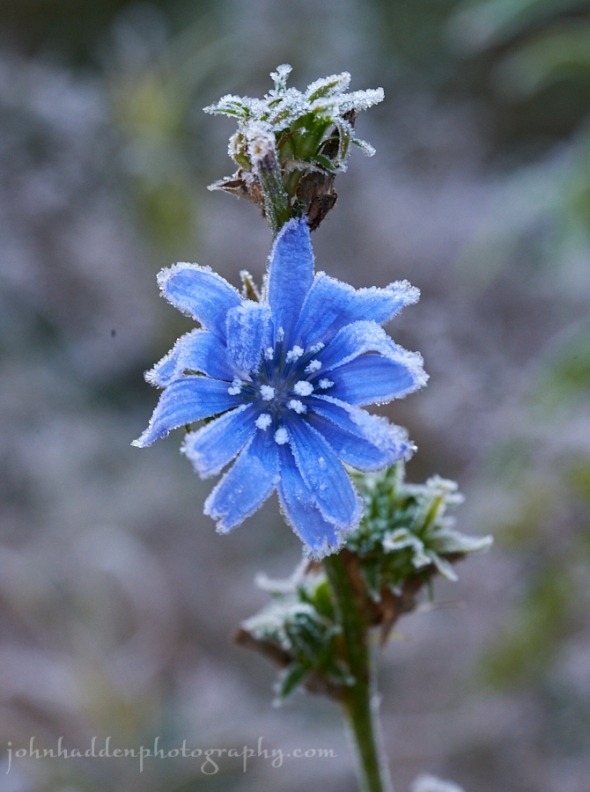
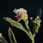
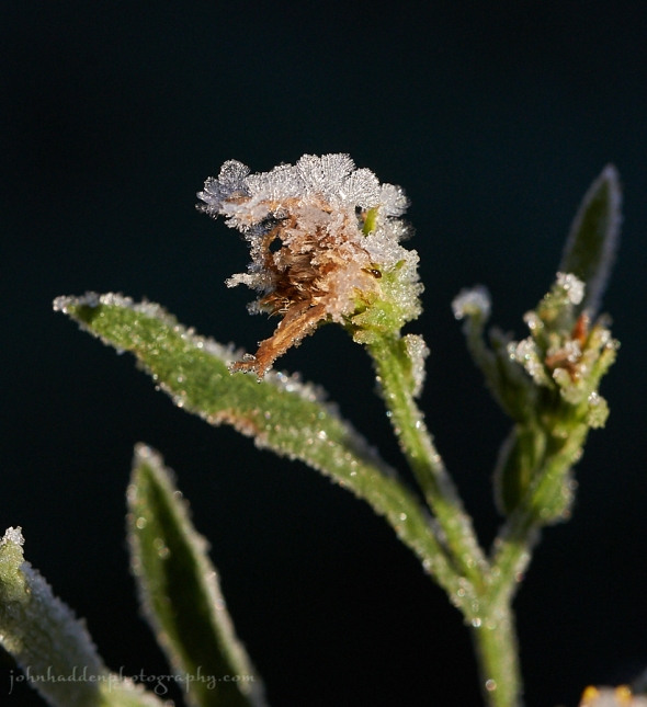
A frosted chicory blossom along our driveway
Morning Observation:
This morning in Huntington at 8:00AM it’s currently 39 degrees under mostly clear skies. Winds are calm. Relative humidity is 96%, dewpoint 39, barometric pressure 30.22” and rising rapidly. Yesterday’s high was 56, and the overnight low was 38.
Forecast:
A large area of high pressure along the US east coast will continue to deliver dry conditions across the region through Sunday. With south to southwest winds in place, temperatures will warm well above seasonal levels for mid to late October beginning today, and continue through the upcoming weekend.
We’ll see partly cloudy skies this morning giving way to generally sunny skies for the afternoon. It’ll be warmer with highs around 66F and light and variable winds. Tonight should be clear and mild with lows around 51F and SSW winds at 5 to 10 mph.
Thursday should be mostly sunny with highs around 68F and SSW winds at 10 to 20 mph. Thursday night should be partly cloudy with lows around 44F and west winds at 10 to 15 mph.
Friday’s looking sunny with highs near 60F and NW winds at 10 to 15 mph. Friday night should be mostly clear with lows around 41F and light and variable winds.
Almanac:
Last year on this date we had a high of 80 and a low of 55. We picked up 0.03″ of rain.
Burlington averages for this date are highs of 56 and lows of 38.
The record high was 84°F in 1947.
The record low was 23°F in 1922.
Sky Notes:
Sunrise: 7:12AM
Sunset: 6:04PM
Length of Visible Light: 11h 51m
Length of Day: 10h 52m
Tomorrow will be 2 minutes 56 seconds shorter
The Moon is a waning crescent, 28 days old with 2% illumination.
Moonrise: 5:43AM
Moonset: 5:55PM
About Today’s Photo:
Yesterday’s heavy frost coated pretty much everything here in the hollow. I spotted this late season chicory blossom as I was headed off for my morning run. Had to pop back in the house for my camera before the sunshine melted the crystals.
Nikon D600, Sigma 105mm macro lens, ISO 1250, f/13, 1/60″ exposure.
Tuesday, October 17, 2017

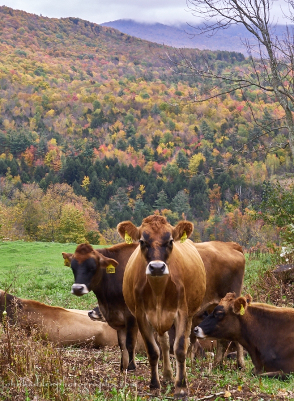
Some of the Taft’s heifers enjoying the fall colors
Morning Observation:
This morning in Huntington at 7:35AM it’s currently a brisk 28 degrees under clear skies. We have a widespread frost here in the hollow. Relative humidity is 96%, dewpoint 27, barometric pressure 30.29” and rising slowly. Yesterday’s high was 60 (at 1:24AM) but the daytime high was 43, and the overnight low was 27.
Forecast:
Strong high pressure currently building over the region will deliver dry weather through the remainder of the week. After a chilly start this morning, a warming trend will begin as winds switch into the south to southwest this afternoon. Highs will top out in the mid to upper 50s today and will moderate into the 60s to low 70s during the next 5 to 7 days—well above the average for mid-October. Our long Indian Summer lives on…
We’ll see sunny skies today with highs around 55F and SSW winds at 10 to 15 mph. Tonight should be partly cloudy skies with lows around 44F and SW winds at 10 to 20 mph.
Wednesday should be mostly sunny with highs near 65F and light and variable winds. Wednesday night should be mostly clear with lows around 51F and SSW winds at 5 to 10 mph.
Thursday’s looking mostly sunny with highs around 69F and SSW winds at 10 to 20 mph. Thursday night should be partly cloudy with lows around 45F and west winds at 10 to 15 mph.
Almanac:
Last year on this date we had a high of 68 and a low of 49. We picked up 0.12″ of rain.
Burlington averages for this date are highs of 57 and lows of 39.
The record high was 85°F in 1947.
The record low was 23°F in 1937.
Sky Notes:
Sunrise: 7:10AM
Sunset: 6:05PM
Length of Visible Light: 11h 53m
Length of Day: 10h 55m
Tomorrow will be 2 minutes 56 seconds shorter
The Moon is a waning crescent, 27 days old with 6% illumination.
Moonrise: 4:37AM
Moonset: 5:26PM
About Today’s Photo:
The fall colors are peaking here in Huntington. Driving over Taft Hill, I just had to stop and take a few shots of some of the Taft’s heifers hanging out in the hillside meadow. I think they might be enjoying the color as much as I do!
Panasonic GX8, Lumix 14-140mm lens @ 61mm, ISO 800, f/18, 1/25″ exposure.
Monday, October 16, 2017

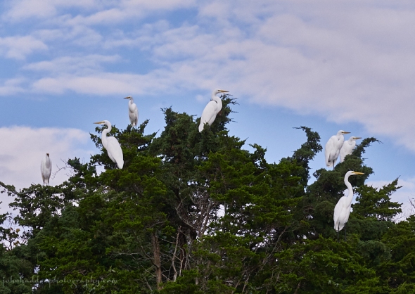
A gang of great egrets near Chatham on Cape Cod
Morning Observation:
This morning in Huntington at 7:15AM it’s currently 42 degrees and drizzling under overcast skies. Relative humidity is 87%, dewpoint 39, barometric pressure 29.93” and rising rapidly. We picked up 0.32” of rain in the past 24hrs. Yesterday’s high was 75, and the overnight low was 42.
Forecast:
The cold front that passed through overnight has ushering in more seasonable temperatures on gusty northwesterly winds. Highs today will be roughly 20 degrees cooler than Sunday, only reaching the low to mid 50s in most areas, and
remaining in the 40s across the northern Adirondacks. Clearing skies and light winds will bring in chilly temperatures tonight, with lows in the mid 20s to mid 30s. We’ll see areas of frost tonight, along with patchy dense fog in the favored river valleys, especially across central and eastern Vermont. Winds will switch into the south on Tuesday, allowing for a warming trend with dry conditions and temperatures bumping up into the 60s and low 70s throughout the week and into the weekend.
We’ll see overcast skies today with highs only around 46F with NW winds at 10 to 15 mph. Tonight should be partly cloudy early giving way to mainly clear skies overnight. Lows will be around 31F with NW winds at 5 to 10 mph.
Tuesday should be sunny with highs around 56F and SSW winds at 5 to 10 mph. Tuesday night should be partly cloudy with lows near 45F and SSW winds at 10 to 15 mph.
Wednesday should be mostly sunny with highs around 65F and SW winds at 5 to 10 mph. Wednesday night should be clear with lows around 50F and south winds at 5 to 10 mph.
Almanac:
Last year on this date we had a high of 68 and a low of 45.
Burlington averages for this date are highs of 57 and lows of 39.
The record high was 84°F in 1947.
The record low was 24°F in 1978.
Sky Notes:
Sunrise: 7:09AM
Sunset: 6:07PM
Length of Visible Light: 11h 56m
Length of Day: 10h 58m
Tomorrow will be 2 minutes 57 seconds shorter
The Moon is a waging crescent, 26 days old with 13% illumination.
Moonrise: 3:31AM
Moonset: 4:57PM
About Today’s Photo:
Great egrets are a familiar site along coastal waters. There were several gangs of them hanging out in trees along the water as we kayaked in Little Pleasant Bay near Chatham, MA on Cape Cod. These birds were hunted to near extinction for their plumes in the 19th century (ladies gotta decorate their hats…), but conservation efforts have made for a robust return.
Panasonic GX8, Lumix 14-140mm lens @ 140mm, ISO 800, f/8, 1/2000″ exposure.
Sunday, October 15, 2017

A horseshoe crab shell on the beach in Chatham
Morning Observation:
This morning in Huntington at 8:15AM it’s currently 62 degrees under overcast skies. Winds are out of the south at 0-3 mph. Relative humidity is 84%, dewpoint 57, barometric pressure 29.89” and falling rapidly. Yesterday’s high was 68, and the overnight low was 53.
Forecast:
Low pressure across the northern Great Lakes region early this morning will track across southeastern Ontario and southern Québec later today. An associated warm front will bring light rain to the St. Lawrence Valley early this morning, and then lift north of the international border resulting in breezy and very
warm conditions for the balance of the day. We can expect high temperatures in
the 70s this afternoon—15 to 20 degrees above normal for mid-October. Later this afternoon and into this evening, a trailing cold front will bring a line of showers with a few embedded thunderstorms possible, especially across northern New York. It’ll be breezy this evening with wind gusts in excess of 40 to 45 mph possible. Much cooler and drier weather is expected for Monday, with dry conditions with moderating temperatures expected for the mid-week period.
We’ll see cloudy skies early today, followed by partial clearing. Highs will be around 74F with SSW winds at 15 to 25 mph. Winds could occasionally gust over 40 mph later this afternoon. Tonight will bring rain and wind early with lingering showers overnight. Lows will be around 46F with WSW winds at 20 to 30 mph. Chance of rain is 90%. Winds could occasionally gust over 40 mph.
Monday should be cloudy and much cooler with highs only around 48F with NW winds at 10 to 15 mph. Monday night should bring clearing skies and some of lowest temperatures of the season with lows around 32F with some mid-20s in colder pokckets. Winds will be out of the NW at 5 to 10 mph.
Tuesday’s looking mainly sunny with highs around 55F and SSW winds at 10 to 15 mph. Tuesday night should be partly cloudy with lows around 45F and SSW winds at 10 to 15 mph.
Almanac:
Last year on this date we had a high of 64 and a low of 27. We had our first heavy frost.
Burlington averages for this date are highs of 57 and lows of 39.
The record high was 80°F in 2014 (we had a high of 81).
The record low was 24°F in 1980.
Sky Notes:
Sunrise: 7:08AM
Sunset: 6:09PM
Length of Visible Light: 11h 59m
Length of Day: 11h 1m
Tomorrow will be 2 minutes 57 seconds shorter
The Moon is a waning crescent, 25 days old with 20% illumination.
Moonrise: 2:23AM
Moonset: 4:24PM
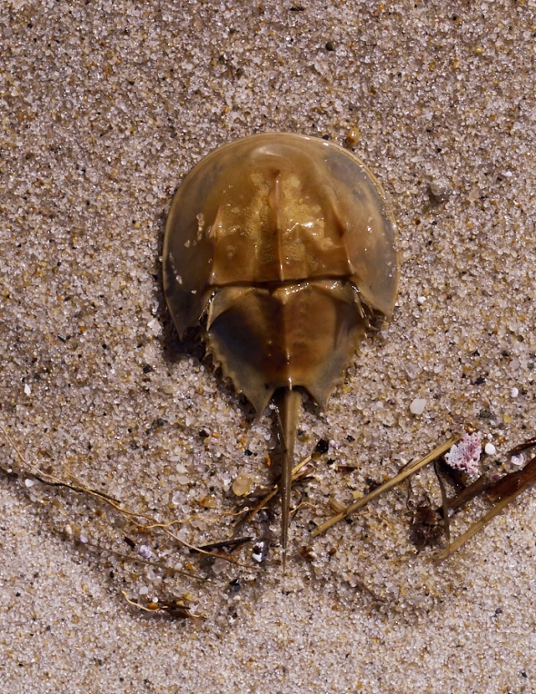
About Today’s Photo:
Horseshoe crabs were much in evidence along the beaches near Chatham on Cape Cod. These invertebrates have remained mostly unchanged for 450 million years making them “living fossils”. Their blood (which is blue) contains a compound (Amebocytes) which is used to make Limulus amebocyte lysate, which is used for the detection of bacterial toxins in medical applications. The blood is commercially harvested for this purpose, but the crabs, for the most part, survive the process.
Panasonic GX8, Lumix 14-140mm lens @ 92mm, ISO 800, f/8, 1/4000″ exposure.
Saturday, October 14, 2017

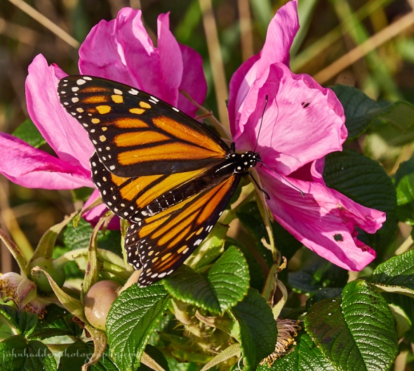
A monarch butterfly stops by a rugosa rose on the beach
Morning Observation:
This morning in Huntington at 8:00AM it’s currently 58 degrees under overcast skies. Winds are calm. Relative humidity is 84%, dewpoint 54, barometric pressure 30.22”. Yesterday’s high was 66, and the overnight low was 58.
Forecast:
A weak cold front will slowly move toward the region today bringing a few showers to northern New York and northern Vermont during the early morning hours. Shower activity will increase over northern half of the region Saturday night into Sunday morning. The front will quickly lift north Sunday morning and most of the region will see breezy and warm conditions with temperatures 15 to 20 degrees above normal for this time of year. Low pressure and another associated cold front will move out of the Great Lakes Sunday driving a line of showers and possible thunderstorms across northern New York Sunday afternoon
and into the evening hours across Vermont.
We’ll see overcast skies today with highs around 68F and SW winds at 5 to 10 mph. Tonight should be cloudy and mild with lows arounds 59F and SE winds at 5 to 10 mph.
Sunday should start partly cloudy in the morning and become overcast in the afternoon. Highs will be 76F with SSW winds at 15 to 25 mph. Sunday night should be cloudy with showers and a rumble of thunder possible early. Lows will be near 45F with west winds at 15 to 25 mph. Chance of rain is 90%.
Monday should be cloudy and cooler with highs around 48F and NW at 10 to 15 mph. Monday night should be partly cloudy early giving way to generally clear conditions overnight. Lows will be around 31F with light and variable winds.
Almanac:
Last year on this date we had a high of 53 and a low of 30. We picked up 0.18″ of rain.
Burlington averages for this date are highs of 58 and lows of 39.
The record high was 79°F in 2014 (we had a high of 77).
The record low was 22°F in 1937.
Sky Notes:
Sunrise: 7:06AM
Sunset: 6:11PM
Length of Visible Light: 12h 2m
Length of Day: 11h 4m
Tomorrow will be 2 minutes 58 seconds shorter
The Moon is a waning crescent, 24 days old with 30% illumination.
Moonrise: 1:16AM
Moonset: 3:49PM
About Today’s Photo:
We spent the past several days down on Cape Cod. While strolling on Harding Beach in Chatham, I spotted this monarch bobbing along the shore stopping by the few still blooming rugosa roses in the dunes. It was nice enough to stick around long enough to get a shot. This little guy’s got quite a long trip ahead of it if it makes it all the way down to Mexico to overwinter…
Panasonic GX8, Lumix 14-140mm lens @ 140mm, ISO 800, f/9, 1/800″ exposure.
Sunday, October 8, 2017

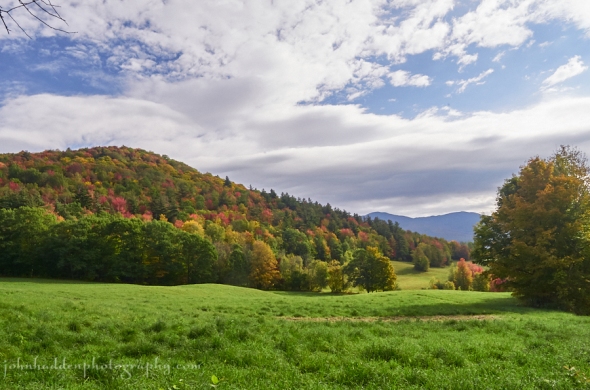
Fall foliage beginning to pop on Shaker Mountain
Morning Observation:
This morning in Huntington at 7:00AM it’s currently a balmy 69 degrees under overcast skies. Winds are out of the south at 0-4 mph. It’s just starting to rain a bit. Relative humidity is 87%, dewpoint 65, barometric pressure 29.74” and falling rapidly. We picked up 0.08” of rain in the past 24hrs. Yesterday’s high was 70, and the overnight low was 62.
Forecast:
A quick moving upper level disturbance along with a cold front will bring a period of widespread rainfall to the region this morning. We should see partial clearing and very warm temperatures for the afternoon once this system shifts east of Vermont. Additional moderate rainfall is expected Monday as tropical moisture from the Gulf of Mexico and the remnants of Nate affect New York and New England. We’ll see continued above normal temperatures for the next 5 to 7 days.
We’ll see showers, possible thunderstorms, and gusty winds this morning, giving way to partly cloudy skies during the afternoon with a lingering chance of showers. Highs will be around 76F with WSW at 20 to 30 mph. Chance of rain is 90%. Tonight should be partly cloudy and becoming overcast overnight with a slight chance of a rain showera. Lows will be around 58F with light and variable winds.
Monday rain is likely. Highs will be around 68F with SE winds at 5 to 10 mph. Chance of rain is near 100% with 1″ to 2″ of rain expected and locally heavy rainfall possible. Showers should continue into Monday night. Lows will be arounds 56F with light and variable winds. Chance of rain is 80%.
Tuesday should be partly cloudy with high around 72F and NW winds at 5 to 10 mph. Tuesday night should be clear with lows around 46F and light and variable winds.
Almanac:
Last year on this date we had a high of 67 and a low of 52.
Burlington averages for this date are highs of 60 and lows of 42.
The record high was 77°F in 1970 (another record poised to fall today if there’s enough sunshine this afernoon…)
The record low was 22°F in 1964.
Sky Notes:
Sunrise: 6:59AM
Sunset: 6:21PM
Length of Visible Light: 12h 20m
Length of Day: 11h 22m
Tomorrow will be 3 minutes
The Moon is waning gibbous, 17.5 days old with 92% illumination.
Moonrise: 8:33PM
Moonset: 10:03AM
About Today’s Photo:
The fall colors are really beginning to pop now. The views up along Shaker Mountain Road are wonderful.
Panasonic GX8, Olympus 9-18mm lens @ 13mm, circular polarizing filter, ISO 800, f/16, 1/160″ exposure.
Saturday, October 7, 2017

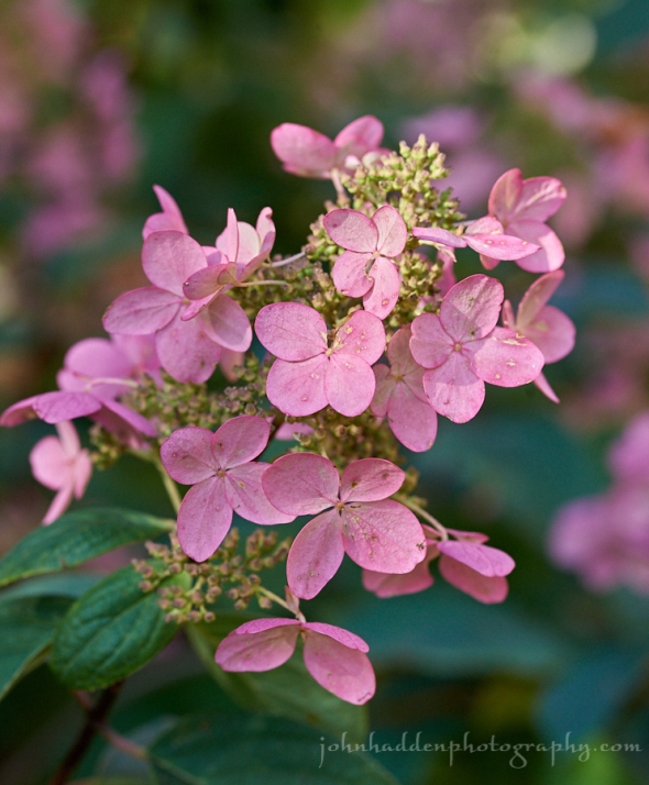
Our patio hydrangea in full fall blush
Morning Observation:
This morning in Huntington at 7:40AM it’s currently 54 degrees under partly cloudy skies. Winds are calm. Relative humidity is 99%, dewpoint 54, barometric pressure 30.08” and steady. We picked up 0.10” of rain in the past 24hrs. Yesterday’s high was 59, and the overnight low was 51.
Forecast:
An active weather pattern will continue as a warm front lifts north across the region today bringing some light rain showers across northern part of the region mid-day. Warm and breezy conditions are expected through tonight. More rain showers are expected Sunday as a cold front crosses the area. We’ll see the remnants of Hurricane Nate on Monday into Tuesday with more rain expected.
We’ll see cloudy skies today with occasional rain showers this afternoon, especially near the Canadian border. Highs will be around 75F with south winds at 10 to 15 mph. Chance of rain is 50%. Tonight should be cloudy early with some clearing expected late. Lows will be around 66F with SSW at 10 to 20 mph.
Sunday showers are likely with the chance of some thunder in the morning, then skies should become partly cloudy late. Highs will be around 74F with SW winds at 15 to 25 mph. Chance of rain is 80%. Sunday night should be partly cloudy early with increasing clouds overnight. Lows will be around 55F with light and variable winds.
Monday will bring rain. Highs will be around 66F with SE winds at 5 to 10 mph. Chance of rain is 100% with rainfall amounts near a half an inch. Showers will continue into Monday night becoming less numerous late. Some rumbles of thunder are possible. Lows will be around 58F with light and variable winds. Chance of rain is 70%.
Almanac:
Last year on this date we had a high of 76 and a low of 42.
Burlington averages for this date are highs of 61 and lows of 42.
The record high was 83°F in 1947.
The record low was 25°F in 1964.
Sky Notes:
Sunrise: 6:58AM
Sunset: 6:23PM
Length of Visible Light: 12h 23m
Length of Day: 11h 25m
Tomorrow will be 3 minutes 0 seconds shorter
The Moon is waning gibbous, 16.4 days old with 97% illumination.
Moonrise: 7:54PM
Moonset: 8:51AM
About Today’s Photo:
The hydrangea on our back patio—that was the nexus of much pollinator activity through the summer—is well into its last fall blush of the season.
Nikon D600, Sigma 105mm macro lens, ISO 1250, f/8, 1/250″ exposure.
Friday, October 6, 2017


A slow moving bumble bee gets last licks on a mum
Morning Observation:
This morning in Huntington at 7:2AM it’s currently 50 degrees under overcasts skies. A few random raindrops are falling. Relative humidity is 98%, dewpoint 50, barometric pressure 30.06” and rising. Yesterday’s high was 72, and the overnight low was 44.
Forecast:
The weather will remain active through the weekend. A weak disturbance will bring clouds and a few light showers mainly this morning before we see partial clearing from north to south this afternoon. A warm front will lift from the south Saturday bringing some more clouds and a chance of showers. A weak cold front will then bring showers late Saturday night and into Sunday. Temperatures will stay much above normal through the weekend possibly reaching record highs on Sunday.
We’ll see showers early today, then mostly cloudy skies in the afternoon. Highs will be around 62F with SW winds at 5 to 10 mph. Chance of rain is 50%. Tonight should be partly cloudy early giving way to cloudy skies late. Lows will be around 52F with light and variable winds.
Saturday should be cloudy with highs around 76F and south winds at 10 to 15 mph. Saturday night should be cloudy with occasional rain after midnight. Lows will be around 67F with south winds at 15 to 25 mph. Chance of rain is 60%.
Sunday should bring light rain early with a mix of sun and clouds in the afternoon. Highs will be around 77F with SW winds at 15 to 25 mph. Chance of rain is 80%. Sunday night should be clear with lows around 53F and light and variable winds.
Almanac:
Last year on this date we had a high of 73 and a low of 43.
Burlington averages for this date are highs of 61 and lows of 42.
The record high was 82°F in 1946.
The record low was 23°F in 1964.
Sky Notes:
Sunrise: 6:57AM
Sunset: 6:25PM
Length of Visible Light: 12h 26m
Length of Day: 11h 28m
Tomorrow will be 3 minutes 1 seconds shorter
The Moon is waning gibbous, 15.3 days old with 99% illumination.
Moonrise: 7:19PM
Moonset: 7:39AM
About Today’s Photo:
It’s getting late in the season for pollinators. Though we’ve had only light frost at our place thus far, the number of bees has greatly diminished as most flowers are past their peak. Some mums out in our back garden attracted a couple of bumble bees however. In the cool morning neither of them were moving very quickly.
Nikon D600, Sigma 105mm macro, ISO 1250, f/13, 1/80″ exposure.
Thursday, October 5, 2017


An inch worm investigates a tired black-eyed Susan in our back garden
Morning Observation:
This morning in Huntington at 7:20AM it’s currently 49 degrees under partly cloudy skies. Winds are calm. Relative humidity is 98%, dewpoint 48, barometric pressure 30.06” and rising. We picked up 0.81” of rain last night (ending a 24-day stretch with little or no rain. It was nice to hear the rain falling!) Yesterday’s high was 79, and the overnight low was 49.
Forecast:
The passage of last evening’s cold front brought much needed rain to the region. Weak high pressure is currently building into the region and will deliver partly sunny skies and warmer than average temperatures. An upper level disturbance will bring some clouds and a slight chance of a shower late tonight into Friday morning. A warm front will bring more clouds and a chance of showers on Saturday followed by a cold front and additional showers Saturday night into Sunday morning. It will continue warm through the weekend with near record warm temperatures in the upper 70s possible especially on Sunday.
We’ll see partly cloudy skies today with highs around 70F and WSW winds at 5 to 10 mph. Tonight should be partly cloudy with lows around 49F and light and variable winds.
Friday should start out mostly cloudy with some sunshine later in the day. Highs will be near 65F with west winds at 5 to 10 mph. Tomorrow night should be partly cloudy with lows around 46F and light and variable winds.
Saturday’s looking cloudy with occasional showers in the afternoon. Highs will be around 70F with SSE winds at 10 to 15 mph. Chance of rain is 40%. Saturday night should be cloudy early with partial clearing expected late. Lows will be around 65F with south winds at 10 to 20 mph.
Almanac:
Last year on this date we had a high of 72 and a low of 44.
Burlington averages for this date are highs of 62 and lows of 43.
The record high was 82°F in 1926.
The record low was 27°F in 1964.
Sky Notes:
Sunrise: 6:55AM
Sunset: 6:27PM
Length of Visible Light: 12h 29m
Length of Day: 11h 31m
Tomorrow will be 3 minutes 1 seconds shorter
The Moon is the full “Hunter’s” moon, 14.2 days old with 100% illumination.
Moonrise: 6:46PM
Moonset: 6:28AM
An interesting bit of moon lore (courtesy of Roger Hill and his Weathering Heights blog): the full moons before and after the autumnal equinox rise about 20 minutes later each night instead of the usualy 50 minutes the rest of the year. The result was more bright moonlight at dusk that gave Native American hunters more time to gather and prepare for winter.
About Today’s Photo:
I came across this slow moving inch worm investigating a battered black-eyed Susan in our back garden yesterday. It was still cool in the morning so it was pretty loggy. If you look really closely, you’ll see that a tiny fly was investigating the inch worm at the same time…
Nikon D600, Sigma 105mm macro, ISO 1250, f/8, 1/250″ exposure.
Wednesday, October 4, 2017


Yellow hawksweed blooming and tufting in our front field
Morning Observation:
This morning in Huntington at 7:35AM it’s currently 51 degrees under partly cloudy skies. Winds are calm. Relative humidity is 91%, dewpoint 48, barometric pressure 30.30” and falling slowly. Yesterday’s high was 73, and the overnight low was 50.
Forecast:
Seasonably warm and breezy conditions are expected today out ahead of an approaching cold front which will cross the region this evening bringing scattered showers and possibly a few rumbles of thunder. Behind the front dry weather and slightly cooler temperatures return for Thursday into Friday before another warming trend arrives for the weekend.
We’ll see sunny to partly cloudy skies today with a stray shower or thunderstorm possible this afternoon. Highs will be around 77F with SSW winds at 10 to 20 mph. Tonight evening showers and thunderstorms will give way to partly cloudy skies after midnight. Lows will be around 53F with WSW winds at 10 to 20 mph. Chance of rain is 90%.
Thursday should be partly cloudy with highs around 69F and west winds at 5 to 10 mph. Thursday night should be partly cloudy with lows around 48F and light and variable winds.
Friday should be partly cloudy with highs around 66F and WNW winds at 5 to 10 mph. Friday night should be partly cloudy with lows around 46F and light and variable winds.
Almanac:
Last year on this date we had a high of 68 and a low of 48. We picked up 0.05″ of rain.
Burlington averages for this date are highs of 62 and lows of 43.
The record high was 82°F in 1891.
The record low was 27°F in 1945.
Sky Notes:
Sunrise: 6:54AM
Sunset: 6:28PM
Length of Visible Light: 12h 32m
Length of Day: 11h 34m
Tomorrow will be 3 minutes 1 seconds shorter
The Moon is waxing gibbous, 13.2 days old with 97% illumination.
Moonrise: 6:15PM
Moonset: 5:19AM
About Today’s Photo:
Like most flowers at this time of year, yellow hawksweed is going to seed. This bright yellow flower disburses its seeds much in the same manner as its look-alike dandelion—via tufts that blow on the wind.
Panasonic GX8, Olympus 60mm macro lens, ISO 800, f/8, 1/2500″ exposure.
Monday, October 2, 2017


Dappled sunshine through oak leaves
Morning Observation:
This morning in Huntington at 7:40AM it’s currently 36 degree under mostly clear skies. Winds are calm. Relative humidity is 98%, dewpoint 35, barometric pressure 30.42” and rising slowly. Yesterday’s high was 65, and the overnight low was 35.
Forecast:
High pressure will remain over the region into Wednesday delivering fair and
seasonably mild temperatures with temperatures on the rise through mid week. A cold front will move through on Wednesday night bringing a chance of showers and possibly a few thunderstorms into Thursday. Unsettled conditions will prevail behind this front as the frontal boundary will begin lifting back north into the area going into the weekend.
We’ll see sunny skies today with highs around 67F and light and variable winds. Tonight should be clear with lows around 47F and light and variable winds.
Tuesday should be mostly sunny with highs around 71F and south winds at 5 to 10 mph. Wednesday night should be partly cloudy with lows around 52F and SSW winds at 5 to 10 mph.
Wednesday should be partly cloudsy and warm with highs around 79F and SSW winds at 10 to 15 mph. Wednesday night should bring rain with a few rumbles of thunder possible. Lows will be around 57F with SW winds at 10 to 15 mph. Chance of rain is 90%.
Almanac:
Last year on this date we had a high of 60 and a low of 53.
Burlington averages for this date are highs of 63 and lows of 44.
The record high was 82°F in 1950.
The record low was 29°F in 1960.
Sky Notes:
Sunrise: 6:52AM
Sunset: 6:32PM
Length of Visible Light: 12h 38m
Length of Day: 11h 40m
Tomorrow will be 3 minutes 2 seconds shorter
The Moon is waxing gibbous, 11.2 days old with 86% illumination.
Moorise: 5:13PM
Moonset: 3:08AM
About Today’s Photo:
Sometimes interesting things happen when you take your macro lens—which is usually pointed at things closes by on the ground—and point it up towards the tree canopy.
Panasonic GX8, Olympus 60mm macro lens, ISO 800, f/2.8, 1/1000″ exposure.
Sunday, October 1, 2017
Morning frost on a dried aster in our front field
Rabbit-rabbit!
Morning Observation:
This morning in Huntington at 7:40AM it’s currently 32 degrees under clear skies. Winds are calm. We have a moderate frost on the ground in the low spots of our front field. Relative humidity is 98%, dewpoint 32, barometric pressure 30.40” and rising. Yesterday’s high was 58, and the overnight low was 31.
Forecast:
High pressure will strengthen across the region today through Wednesday bringing warming temperatures and fair, dry weather. The next threat of rainfall will arrive Wednesday night and into early Friday as increasing moisture along an advancing cold front pushes into the region.
We’ll see partly cloudy skies today with highs around 64F and WNW winds at 5 to 10 mph. Tonight should be clear skies with lows around 42F and light and variable.
Monday should be sunny with highs around 68F and light and variable winds. Monday night should be mostly clear with lows around 46F and light and variable winds.
Tuesday looking mostly sunny with a few afternoon clouds. Highs will be around 71F with south winds at 5 to 10 mph. Tuesday night should be partly cloudy with lows around 51F and south winds at 5 to 10 mph.
Almanac:
Last year on this date we had a high of 59 and a low of 42. We picked up 0.02″ of rain.
Burlington averages for this date are highs of 63 and lows of 44.
The record high was 80°F in 1922.
The record low was 27°F in 1963.
Sky Notes:
Sunrise: 6:51AM
Sunset: 6:34PM
Length of Visible Light: 12h 41m
Length of Day: 11h 43m
Tomorrow will be 3 minutes 2 seconds shorter
The Moon is waxing gibbous, 10.3 days old with 79% illumination.
Moonrise: 4:39PM
Moonset: 2:06AM
About Today’s Photo:
This morning’s moderate frost coated the grasses and dried flowers in the low spot in our front field. As the sun popped up over the trees to the east, the crystals sparkled. Hard to believe we were under the onslaught of 90 degree temperatures just a few days ago!
Nikon D600, Sigma 105mm macro lens, ISO 1250, f/13, 1/800″ exposure.
