Monday, December 31, 2018

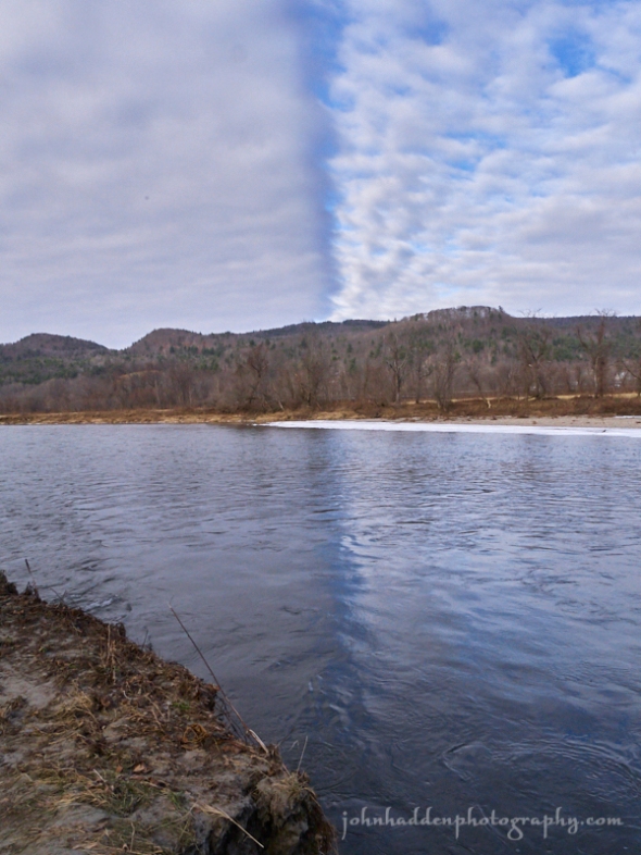
An interestingly bifurcated sky along the Winooski River yesterday
Morning Observation:
This morning in Huntington at 7:50AM it’s currently 32 degrees under mostly cloudy skies. Winds are calm. Relative humidity is 82%, dewpoint 27, barometric pressure 30.29”. We’re down to bare ground at the snow stake. Yesterday’s high was 29, and the overnight low was 28.
Forecast:
Low pressure system moving quickly out of the Ohio River valley this morning will track along the Saint Lawrence valley tonight bringing a mix of rain, freezing rain, sleet, and snow to the region. Precipitation should begin tonight in our area—starting off as a mix and changing over to rain overnight. 3″ to 5″ of snow are possible from the spine of the Greens eastward where colder temperatures will hold out the longest. Valley locations west will see mostly rain around a half an inch or less. Precipitation will wind down by midday on New Year’s Day with some lingering snow showers possible as high pressure and cooler air moves in behind the departing system. Wednesday and Thursday are looking dry and seasonable before another warm up arrives Friday into Saturday.
Today will start off partly sunny with a high near 38 with south winds 6 to 9 mph. Precipitation should arrive near sunset. Tonight rain and snow are likely, becoming all rain after midnight. Lows will be around 34 with south winds 7 to 16 mph. Chance of precipitation is 100% with little or no snow accumulation expected.
New Year’s Day rain showers are likely before 2:00PM, diminishing to a chance of rain and snow showers as the system moves east. It’ll be cloudy with temperatures topping out near 42 by 9:00am and then falling during the remainder of the day. It’ll be breezy with a south wind 13 to 22 mph and gusting to 33 mph. Chance of precipitation is 60% is with little or no snow accumulation expected. Tuesday night should be mostly cloudy and chilly with a low around 6 and northwest winds 9 to 14 mph.
Wednesday’s looking sunny with a high near 17 and northwest winds 3 to 7 mph.
Wednesday night should be cloudy with a low around 9 and calm winds becoming southerly around 5 mph after midnight.
Almanac:
Last year on this date we had a high of 1 and a low of -14. We picked up 0.30″ of new snow and had 8″ at the stake.
Burlington averages for this date are a low of 13 and a high of 29.
The record low was -19 in 1963.
The record high was 56 in 1965.
Sky Notes:
Sunrise: 7:27ASM
Sunset: 4:22PM
Length of day: 8:54:42
Today will be 0:43 longer than yesterday.
The Moon is a waning crescent, 24 days old with 29% illumination.
Moonrise: 1:54AM
Moonset: 1:06PM
About Today’s Photo:
We took a little walk through the Beeken Riverside Park in Richmond yesterday. As I came back towards the parking lot down by the river, I noticed this interesting phenomenon in the sky. Two differently textured areas of altocumulus clouds created a distinct line in the sky that was reflected in the flowing water of the Winooski River. I just had to get a shot.
Panasonic GX8, Lumix 14-140mm lens @ 14mm, ISO 800, f/14, 1/320″ exposure.
Sunday, December 30, 2018

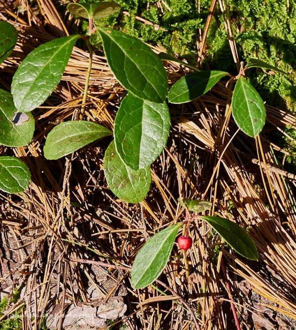
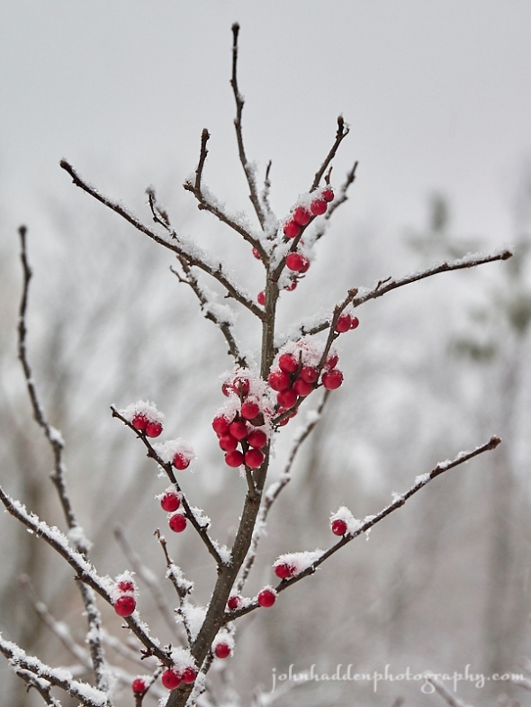
Glossy wintergreen leaves and a single red berry
Morning Observation:
This morning in Huntington at 8:15AM it’s currently 17 degrees under mostly cloudy skies. Winds are calm. Relative humidity is 83%, dewpoint 13m, barometric pressure 30.21” and steady. We picked up a dusting of snow in the past 24hr hours but are still down to bare ground at the stake. Yesterday’s high was 46 (at 4:15AM), and the overnight low was 11.
Forecast:
We’ve got a quiet and seasonable day on tap today courtesy of high pressure over the region. We’ll see dry conditions and colder temperatures tonight into the first half of Monday before low pressure moving out the Mississippi River valley lifts a warm front into the region New Years Eve night bringing another round of wintry mix to the region. We’ll see snow, sleet, and possible freezing rain late New Year’s Eve giving way to rain New Year’s Day and wrapping up in snow once again as cold front swings through on the backside of the system. We may end up with a few inches of snow after it’s all said and done. High pressure and seasonable temperature will pull in for Wednesday and Thursday before a possible coastal storm affects the region Friday. Stay tuned!
We’ll see mostly cloudy today giving way to sunny skies later in the day. Highs will be near 27 with calm winds becoming southerly around 5 mph. Tonight should be mostly cloudy with a low around 22 and south winds 3 to 6 mph.
Monday should be partly sunny with a high near 37 and south winds 3 to 7 mph. Monday night rain and snow likely before 11:00pm changing over to rain after 1:00am. Lows will be around 34 with south winds 7 to 10 mph gusting 20 mph. Chance of precipitation is 100% with snow and sleet accumulations of 1″ to 2″ possible.
New Year’s Day rain is likely before noon transitioning to snow showers after by sunset. It’ll be cloudy with a high near 38 and southwest winds 7 to 11 mph becoming northwesterly in the morning. Chance of precipitation is 60% with snow accumulations of less than 1/2″ expected. Tuesday night should be cloudy with a 40% chance of snow showers. Lows will be around 11 with northwest winds around 7 mph.
Almanac:
Last year on this date we had a high of 11 and a low of -14. We picked up 0.60″ of new snow and had 7.5″ at the stake.
Burlington averages for this date are a low of 13 and a high of 29.
The record low was -15 in 1963.
The record high was 51 in 1990.
Sky Notes:
Sunrise: 7:27AM
Sunset: 4:21PM
Length of day: 8:53:59
Today will be 0:38 longer than yesterday.
The Moon is a waning crescent, 23 days old with 39% illumination.
Moonrise: 12:46AM
Moonset: 12:38PM
About Today’s Photo:
Wintergreen is a common plant in New England (this shot is from Maine). The leaves and berries have been used for generations to alleviate rheumatic symptoms, headache, fever, sore throat, and various aches and pains. Wintergreen contains salicylic acid—the active ingredient in aspirin. When I’m hiking in the woods I’ll often crush a lead or two and suck on it while walking. The minty flavor with a hint of tannins make for a refreshing trail snack.
Panasonic GX8, Lumix 14-140mm lens @ 61mm, ISO 800, f/8, 1/160″ exposure.
Saturday, December 29, 2018

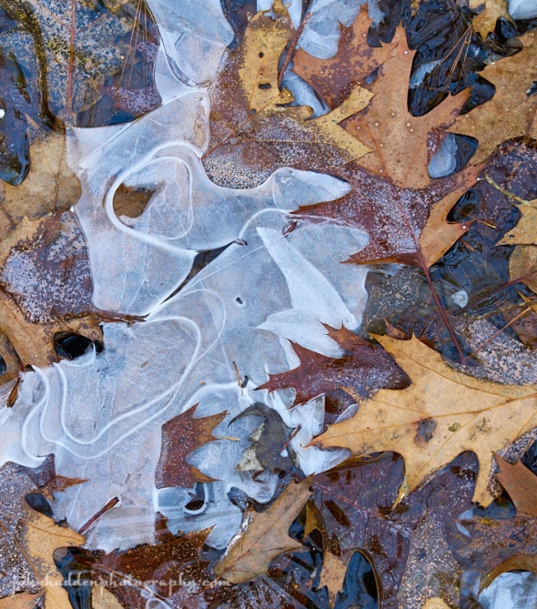
Oak leaves & ice on the forest floor
Morning Observation:
This morning in Huntington at 8:20AM it’s currently 41 degrees under overcast skies. Winds are out of the west at 2-6 mph. Relative humidity is 77%, dewpoint 35, barometric pressure 29.85” and rising rapidly. We picked up 0.55” of rain in the past 24hrs and are down to bare ground at the the snow stake. Yesterday’s high was 45 and the overnight low was 36 at 2:00AM (topping out at 46 at 4:15AM last night).
Forecast:
We’re on the tracks of a bit of a temperature roller-coaster over the next few days. A reinforcing cold front will cross the region today bringing some scattered light rain and snow showers which will end by this afternoon. Temperatures will top out this morning in the low 40s (indeed we had 46 degrees at 4:15AM this morning) dropping towards the single digits by tonight and mid 20s tomorrow. Another messy system will impact the area Monday night into Tuesday bringing another round mixed precipitation for New Years Eve. We should see snow, sleet, rain, then snow again Tuesday afternoon as temperatures drop back down to seasonable levels for the middle of next week.
We’ll see a slight chance of rain showers this morning before 11:00am, then a slight chance of snow showers this afternoon. It’ll be mostly cloudy with a temperature falling to around 24 by sunset. Winds will be westerly around 14 mph becoming northerly in the afternoon. Chance of precipitation is 20%. Tonight should be mostly cloudy with a low around 7 and north winds 8 to 13 mph becoming light and variable after midnight.
Sunday should be sunny with a high near 24 and calm winds becoming southwesterly around 6 mph in the afternoon. Sunday night should be mostly cloudy with a low around 20 and south winds around 6 mph.
Monday’s looking partly sunny with a high near 37 and south winds 5 to 7 mph.
Monday night should bring rain, snow, and sleet between 10:00pm and midnight, then rain after midnight. Lows will be around 32 with southeast winds around 8 mph. Chance of precipitation is 90% with new precipitation amounts between 1/4″ and 1/2″ possible.
Almanac:
Last year on this date we had a high of 1 and a low of -15 (brrrr!) We had 7″ of snow at the stake.
Burlington averages for this date are a low of 13 and a high of 29.
The record low was -13 in 1989.
The record high was 58 in 1984.
Sky Notes:
Sunrise: 7:27AM
Sunset: 4:20PM
Length of day: 8:53:21
Today will be 0:34 longer than yesterday.
The Moon is in its last quarter, 22 days old with 50% illumination.
No Moonrise
Moonset: 12:10PM
About Today’s Photo:
Oak leaves and ice form a layerd collage on the forest floor somewhere in southern Maine.
Panasonic GX8, Lumix 14-140mm lens @ 37mm, ISO 800, f/8, 1/40″ exposure.
Friday, December 28, 2018

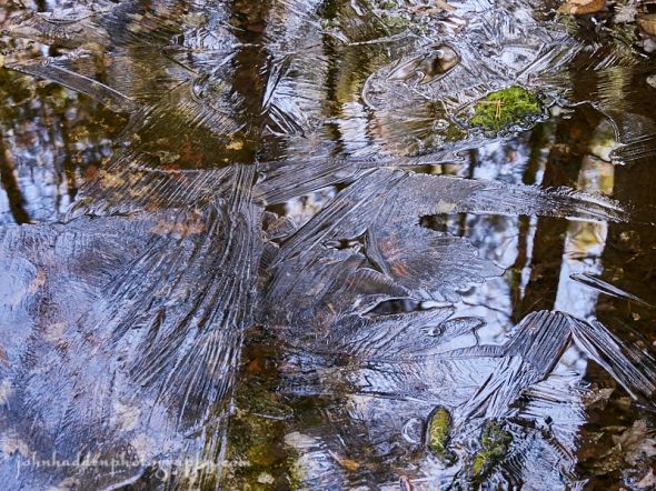
A thin skim of ice over a vernal pool
Morning Observation:
This morning in Huntington at 7:35AM it’s currently 37 degrees and raining lightly under overcast skies. Winds are out of the south at 4-7mph. Relative humidity is 89%, dewpoint 34, barometric pressure 30.12” and falling rapidly. We picked up 0.10” of sleet and 0.04” of melted precipitation overnight. Yesterday’s high was 30, and the overnight low was 29.
There is a Winter Weather Advisory in effect for our region until 3:00PM this afternoon.
Forecast:
Low pressure over the northern Great Lakes this morning will drag a warm front and then cold front to cross our region today bringing a mixed bag of precipitation types this morning before changing over to rain later this afternoon. Strong southerly winds are expected, gusting to 50 mph in the Champlain Valley. High pressure will move in behind the departing low on Saturday bringing colder and drier conditions going into the weekend.
We’ll see any mixed precipitation change over to plain rain later this morning. Highs will be near 45 with south winds 16 to 22 mph gusting to 34 mph. Chance of precipitation is 90%. Tonight rain is likely. It’ll be mostly cloudy with a low around 35 and south winds 13 to 16 mph. Chance of precipitation is 60%.
Saturday should bring a 40% chance of rain showers before 8:00AM tapering to snow showers by midday. It’ll be mostly cloudy with temperatures falling to around 21 by sunset. Winds will be westerly at 11 to 15 mph, becoming northwesterly in the afternoon. Saturday night should be partly cloudy with a low around 6 and northwest winds 6 to 11 mph becoming light after midnight.
Sunday’s looking mostly sunny with a high near 24 and calm winds becoming southwesterly around 5 mph in the afternoon. Sunday night should be partly cloudy with a low around 17 and south winds around 6 mph.
Almanac:
Last year on this date we had a high of 1 and a low of -13 (brrr!) We picked up 0.25″ of new snow and had 7″ at the stake.
Burlington averages for this date are a low of 13 and a high of 29.
The record low was -16 in 1960.
The record high was 57 in 1982.
Sky Notes:
Sunrise: 7:27AM
Sunset: 4:20PM (!!!)
Length of day: 8:52:47
Today will be 0:29 longer than yesterday.
The Moon is waning gibbous, 21 days old with 62% illumination.
Moonrise: 11:36PM
Moonset: 11:41AM
About Today’s Photo:
We visited my sister in Maine over the holiday. The woods behind her house have numerous vernal pools that were filled with water after the recent rains. Cold overnight temperatures had created thin skims of ice with lovely wing and feather textures.
Panasonic GX8, Lumix 14-140mm lens @ 37mm, ISO 800, f/4.6, 1/20″ exposure.
Saturday, December 22, 2018

Fargo Brook is noisy this morning
Morning Observation:
This morning in Huntington at 8:00AM it’s currently 45 degrees and raining under overcast skies. Winds are out of the south at 0-4 mph. Relative humidity is 91%, dewpoint 42, barometric pressure 29.19” and rising. We picked up a whopping 1.45” of rain in the past 24hrs, and we’re down to bare ground at the snow stake. Yesterday’s high was 58 (right around midnight last night), and the overnight low was 45.
A Flood Watch remains in effect for our region until 1:00PM this afternoon.
Forecast:
The low pressure system that’s been responsible for the rains is currently moving to our northeast. A surface cold front will sweep across the region around midday today bringing an transition from rain to light snow showers in the mountains. We should see a dusting in the valleys with up to 2″ to 4″ along in the higher terrain along the western slopes of the Greens. Quiet and seasonably cool conditions will return through much of the upcoming holiday week, with the chance of a bit of snow Sunday night into Monday.
We’ll see rain showers today transitioning to snow showers this afternoon. Temperature will fall through the day to around 29 by nightfall. Winds will be westerly 5 to 14 mph. Chance of precipitation is 80% with snow accumulation of less than 1/2″ expected. Tonight should be cloudy, gradually becoming partly cloudy, with a low around 21 and west winds 10 to 16 mph.
Sunday should be mostly sunny with a high near 27 and northwest winds 5 to 8 mph becoming calm in the afternoon. Sunday night should bring a 30% chance of snow showers. It’ll be mostly cloudy with a low around 19 and calm winds. Snow accumulations of less than 1/2″ are expected.
Monday should bring a 40% chance of snow showers. It’ll be cloudy with a high near 30 and calm winds becoming northwesterly around 6 mph in the afternoon. Snow accumulation of less than 1″ is expected. Monday night should be mostly cloudy with a low around 13 and north winds around 5 mph becoming calm.
Almanac:
Last year on this date we had a high of 25 and a low of 5. We picked up 8.5″ of new snow during the day and had 9″ at the stake.
Burlington averages for this date are a low of 16 and a high of 31.
The record low was -20 in 1955.
The record high was 57 in 1990.
Sky Notes:
Sunrise: 7:25AM
Sunset: 4:16PM
Length of day: 8:51:00
Today will be 0:01 longer than yesterday.
The Moon is the full “Cold” moon (Northeast Native American), 14 days old with 100% illumination.
Moonrise: 4:31PM
Moonset: 7:02AM
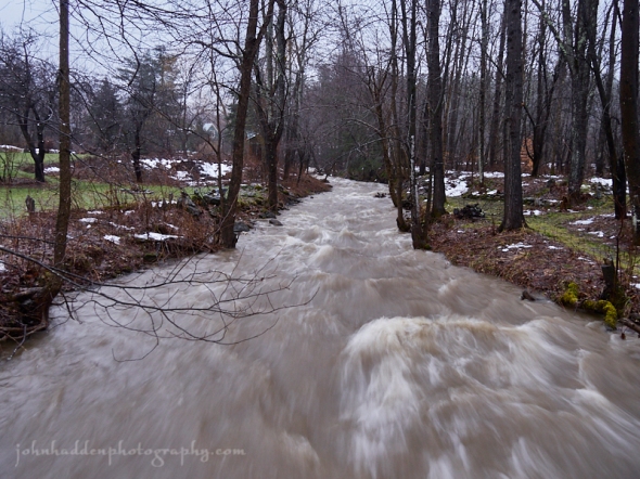
About Today’s Photo:
With close to 2″ of rain, warm temperatures, and copious snowmelt, many area streams are at or above flood stage this morning. Though not out of it banks, Fargo Brook is roaring loudly.
Panasonic GX8, Lumix 14-140mm lens @ 14mm, ISO 400, f/4, 1/20″ exposure.
Friday, December 21, 2018: The Winter Solstice

Flowing water, snow, and ice in Fargo Brook
Happy Winter Solstice!
Morning Observation:
This morning in Huntington at 7:40AM it’s currently 50 degrees and raining lightly under overcast skies. Winds are out of the south at 7-10 mph and gusting to 31 mph. Relative humidity is 83%, dewpoint 45, barometric pressure 29.50” and falling rapidly. We’ve picked up 0.38” of rain overnight and have 3” of snow at the stake. Yesterday’s high was 47, and the overnight low was 34.
There is a Wind Advisory in place for our region until 1:00PM this afternoon. There is also an Areal Flood Watch in effect until 1:00PM Saturday.
Forecast:
We’ve got wild and wooly weather underway here courtesy of a strong, moisture laden storm system that’s racing our way from the Ohio River valley. We’ll see widespread rain, strong gusty winds, very mild temperatures, and the threat of river flooding due to snow melt today and going into Saturday. An associated cold front will swing through Saturday afternoon bringing cooler temperatures and a trace of snow. Things will quiet down by Sunday into early next week as temperatures cool back toward more typical late December levels. A weak trough may bring some light snow Sunday night into Monday.
We’ll see rain today with a high near 54 and southeast winds 24 to 29 mph gusting to 47 mph, then decreasing to 11 to 16 mph in the afternoon. Chance of precipitation is 100% with precipitation amounts between 1/4″-1/2″ possible. Tonight showers are likely. It’ll be cloudy with a low around 41 and south winds 11 to 16 mph. Chance of precipitation is 70% with precipitation amounts of less than 1/10″ possible.
Saturday rain showers are likely before noon, then a chance of snow showers after 2:00pm. It’ll be cloudy with a temperature falling to around 31 by sunset. Winds will be out of the south at 10 to 16 mph and becoming westerly in the afternoon. Chance of precipitation is 60% with snow accumulation of less than 1/2″ possible. Saturday night should be mostly cloudy with a low around 22 and west winds 11 to 16 mph.
Sunday’s looking mostly sunny with a high near 30 and northwest winds 5 to 8 mph becoming light and variable in the afternoon. Sunday night should bring a 30% chance of snow showers. It’ll be mostly cloudy with a low around 20 and calm winds.
Almanac:
Last year on this date we had a high of 19 and a low of 4. We had 3″ of snow at the stake.
Burlington averages for this date are a low of 16 and a high of 31.
The record low was -22 in 1955.
The record high was 61 in 1957.
Sky Notes:
Sunrise: 7:24AM
Sunset: 4:15PM
Length of day: 8:50:59
Today will be 0:03 shorter than yesterday.
The Moon is waxing gibbous, 13.2 days old with 97% illumination.
Moonrise: 3:38PM
Moonset: 5:52AM
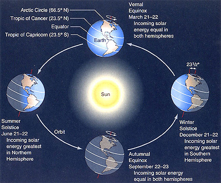
The Winter Solstice occurs today at 5:22PM. The Solstice marks the shortest day of the year for the Northern hemisphere (6 hours and 41 minutes shorter than at the Summer Solstice) and marks the astronomical start of winter for us. It is the point in the Earth’s yearlong orbit around the sun when the Earth’s axis is inclined fully (~23.5 degrees) to the sun. Southern latitudes are now in summer. From today until the Summer Solstice in June, our days will continue to get longer. You can read more about the Solstice here.
And here’s a handy graphic for you:
Thursday, December 20, 2018

Frost on the inside of our garage window
Morning Observation:
This morning in Huntington at 7:00AM it’s currently 18 degrees under clear skies. Winds are calm. Relative humidity is 93%, dewpoint 16, barometric pressure 30.08” and steady. We have 5” of snow at the stake. Yesterday’s high was 32, and the overnight low was 18.
Forecast:
With high pressure departing to the east this morning, we have a mostly sunny day on tap at least going into the afternoon. Thereafter, we’ll be under the gun of a strong, moisture laden storm system approaching from the southeast which will bring a wide variety of weather conditions to the region over the next 48 hours. We’ll see very mild temperatures, moderate rainfall, strong gusty winds, and considerable snow melt. Some areas of stream and river flooding are strong possibilities later Friday into Friday night. A areal flood watch is in effect from late tonight through Saturday afternoon, and a wind advisory has also been posted for our region from 5:00AM Friday to 1:00PM Friday. Behind this system generally quiet and seasonably cold weather will return to the region by early next week with the chance of a bit of snow for Christmas day.
We’ll see mostly sunny skies today before clouds move in this afternoon. Highs will be near 43 with south winds 5 to 7 mph. Tonight rain is likely mainly after 2:00am. Lows will be around 37 with southeast winds 6 to 11 mph increasing to 12 to 17 mph after midnight and gusting to 32 mph. Chance of precipitation is 80% with precipitation amounts between 1/10″-1/4″ possible.
Friday (the Winter Solstice) rain is likely. Highs will be near 54 with southeast winds 23 to 28 mph and gusting to 47 mph. Chance of precipitation is 100% with precipitation amounts between 1/4-1/2″ possible. Friday night rain is likely. Lows will be around 42 with south winds 9 to 14 mph gusting to 28 mph. Chance of precipitation is 90% with precipitation amounts between 1/10″-1/4″ possible.
Saturday rain is likely before 3:00pm with a chance snow showers after 4pm. It’ll be cloudy with a high near 44, dropping towards the 20s in the afternoon, and southwest winds 10 to 13 mph gusting to 25 mph. Chance of precipitation is 60% with snow accumulation of less 1/2″ possible. Saturday night should be mostly cloudy with a 30% chance of lingering snow showers. Lows will be around 22 with west winds 11 to 16 mph.
Almanac:
Last year on this date we had a high of 33 and a low of 16. We picked up 0.04″ of rain and 0.30″ of snow and had 3″ of snow at the stake.
Burlington averages for this date are a low of 17 and a high of 32.
The record low was -22 in 1942.
The record high was 62 in 1957.
Sky Notes:
Sunrise: 7:24AM
Sunset: 4:15PM
Length of day: 8:51:02
Today will be 0:08 shorter than yesterday.
The Moon is waxing gibbous, 12 days old with 92% illumination.
Moonrise: 2:55PM
Moonset: 4:40AM
If you’ve been up early enough, you may have noticed a particularly bright object in the southeastern sky before dawn. This is Venus and she’s a beauty!
About Today’s Photo:
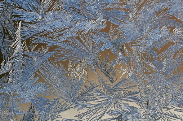
Cold morning temperatures allow for the blooming of lovely frost formations on the inside of our garage windows.
Nikon D600, Sigma 105mm macro lens, ISO 400m, f/10, 1/800″ exposure.
Wednesday, December 19, 2018

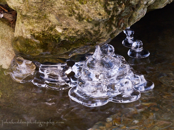
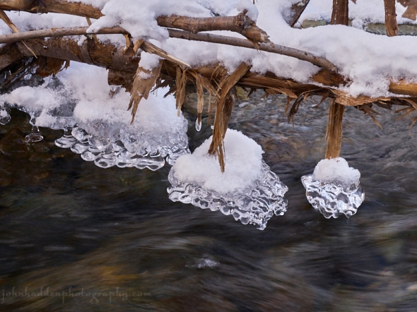
Ice bells forming in Fargo Brook
Morning Observation:
This morning in Huntington at 7:35AM it’s currently 9 degrees under mostly clear skies. Winds are calm. Relative humidity is 91%, dewpoint 7, barometric pressure 30.12” and steady. We have 5” of snow at the stake. Yesterday’s high was 21, and the overnight low was 8.
Forecast:
High pressure will crest over the region today into Thursday bringing partly sunny skies and moderating temperatures. A strong storm system moving out of the Ohio River valley Thursday will bring breezy and very mild conditions along with periods of rain to our region late Thursday night into Saturday. Temperatures could bump towards the low 50s in valley locations Friday. Snow melt and rain may cause river levels to rise by Saturday. Behind this system the weather looks to be quiet and seasonably colder for Christmas day and the early part of next week.
We’ll see sunny skies today with a high near 31 and southwest winds 6 to 8 mph.
Tonight should be mostly clear with a low around 20 and south winds around 6 mph.
Thursday should start out being mostly sunny with a high near 41 and south winds 3 to 7 mph. Clouds will arrive in the afternoon. Thursday night rain is likely late. Lows will be around 33 with southeast winds 7 to 10 mph. Chance of precipitation is 80% with precipitation amounts between 1/10″-1/4″ possible.
Friday rain is likely. Highs will be near 53 with southeast winds 14 to 17 mph gusting to 33 mph. Chance of precipitation is 80% with precipitation amounts between 1/4″-1/2″ possible. Friday night rain is likely mainly before 1:00am. It’ll be cloudy with a low around 41 and southeast winds 8 to 13 mph gusting to 24 mph. Chance of precipitation is 60% with precipitation amounts between a 1/10″-1/4″ possible.
Almanac:
Last year on this date we had a high of 41 and a low of 5. We had 4″ of snow at the stake.
Burlington averages for this date are a low of 17 and a high of 32.
The record low was -18 in 1942.
The record high was 48 in 1957.
Sky Notes:
Sunrise: 7:23AM
Sunset: 4:14PM
Length of day: 8:51:10
Today will be 0:12 shorter than yesterday.
The Moon is waxing gibbous, 11 days old with 85% illumination.
Moonrise: 2:19PM
Moonset: 3:30AM
About Today’s Photo:
Another interesting ice formation in Fargo Brook. These “ice bells” formed in a quiet eddy of Fargo Brook where the water gently lapped up against the rock. I like the way the ice hovers above the water.
Panasonic GX8, Lumix 14-140mm lens @ 88mm, ISO 1250, f/13, 1/25″ exposure.
Tuesday, December 18, 2018

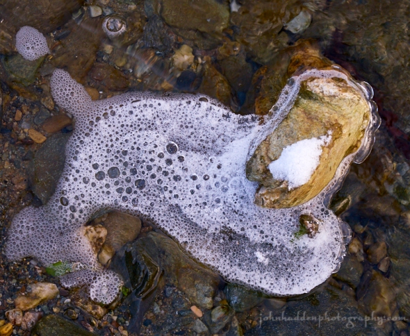
Frozen foam in Fargo Brook
Morning Observation:
This morning in Huntington at 7:40AM it’s currently 17 degrees under overcast skies. Winds are out of the west at 0-4 mph. Relative humidity is 77%, dewpoint 11, barometric pressure 29.97” and rising rapidly. We picked up 1” of new snow in the past 24hrs and have 5” at the stake. Yesterday’s high was 36, and the overnight low was 17.
Forecast:
After the passage of yesterday’s cold front and accompanying snow showers, high pressure is building into the region today and will deliver gusty northwest winds and chilly temperatures across the region. Temperatures will begin to moderate on Wednesday as winds turn southerly under partial sunshine. A strong storm system will bring widespread moderate rainfall, gusty winds, and mild temperatures to the region early Friday morning into Saturday.
We’ll see mostly cloudy skies today with a 30% chance of lingering snow showers this morning. Highs will be near 21 with northwest winds 13 to 18 mph gusting to 33 mph. Tonight should be partly cloudy with a low around 10 and northwest winds 5 to 10 mph becoming light and variable after midnight.
Wednesday should be mostly sunny with a high near 31 and light south winds increasing to 5 to 9 mph in the morning. Wednesday night should be partly cloudy with a low around 22 and south winds around 6 mph.
Thursday’s looking partly sunny with a high near 41 and south winds 3 to 5 mph.
Thursday night rain or freezing rain is likely in the early morning (Friday). Lows will be around 33 with southeast winds 5 to 11 mph. Chance of precipitation is 80% with precipitation amounts between 1/10″ and 1/4″ possible.
Almanac:
Last year on this date we had a high of 33 and a low of 5. We had 4″ of snow at the stake.
Burlington averages for this date are a low of 17 and a high of 32.
The record low was -5 in 1989.
The record high was 50 in 1996.
Sky Notes:
Sunrise: 7:23AM
Sunset: 4:14PM
Length of day: 8:51:10
Today will be 0:12 shorter than yesterday.
The Moon is waxing gibbous, 10 days old with 77% illumination.
Moonrise: 1:48PM
Moonset: 2:22AM
About Today’s Photo:
I hadn’t really taken notice of this phenomenon before—foam gathering around an obstacle and freezing in place. The bubbles look perfectly normal, but all but the very top left “fin” (if you see a whale like I do…) were encased in ice.
Panasonic GX8, Lumix 14-140mm lens @ 46mm, ISO 800, f/8, 1/100″ exposure.
Monday, December 17, 2018


Hoarfrost crystals on ice
Morning Observation:
This morning in Huntington at 7:25AM it’s currently 33 degrees under overcast skies. There’s a hint of precipitation falling. Winds are calm. Relative humidity is 88%, dewpoint 30, barometric pressure 29.70” and falling slowly. We have 4.75” of snow at the stake. Yesterday’s high was 40, and the overnight low was 32.
Forecast:
An upper trough approaching from the northwest will provide the region with scattered to numerous snow showers this afternoon and tonight. Snowfall amounts should range from a dusting to an inch in valley locations, to 1″-3″ around 1000′, and up to 6″ along the spine of the Greens. High pressure will build in Tuesday bringing dry and cool conditions through Thursday. The next chance for precipitation arrives Thursday night as a coastal low brings mixed precipitation Thursday night and rain Friday into Saturday, along with well above normal temperatures.
Today snow is likely after after 5:00PM. It’ll be cloudy with a high near 37 and light and variable winds becoming northwesterly 8 to 13 mph in the afternoon and gusting to 24 mph. Chance of precipitation is 60% with total daytime snow accumulation of less than 1/2″ possible. Tonight snow is likely. Lows will be around 17 with northwest winds around 17 mph gusting to 30 mph. Chance of precipitation is 90% with new snow accumulation of 1″-3″ possible.
Tuesday should bring a 40% chance of snow showers in the morning. It’ll be cloudy with a high near 21 and northwest winds 13 to 16 mph gusting to 28 mph. Tuesday night should be partly cloudy with a low around 10 and northwest winds 5 to 11 mph.
Wednesday’s looking sunny with a high near 33 and calm winds becoming southerly 5 to 7 mph in the afternoon. Wednesday night should be partly cloudy with a low around 22 and south winds 3 to 7 mph.
Almanac:
Last year on this date we had a high of 18 and a low of -4. We picked up 0.30″ of new snow and had 4″ at the stake.
Burlington averages for this date are a low of 18 and a high of 33.
The record low was -11 in 2013 (we had a low of -14).
The record high was 56 in 2000 (we had a high of 54).
Sky Notes:
Sunrise: 7:22AM
Sunset: 4:13PM
Length of day: 8:51:40
Today will be 0:22 shorter than yesterday.
The Moon is waxing gibbous, 9 days old with 68% illumination.
Moonrise: 1:21PM
Moonset: 1:17AM
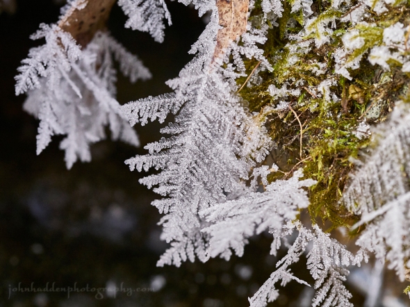
About Today’s Photo:
This shot is from a few days back when temperatures were cold. Long delicate hoarfrost crystals form on top of ice of Fargo Brook.
Panasonic GX8, Olympus 60mm macro lens, ISO 800m f/8, 1/80″ exposure.
Sunday, December 16, 2018

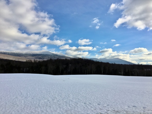
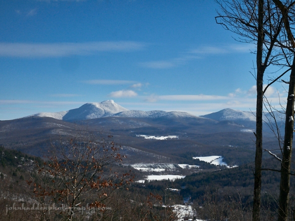
A fine view Mt. Ellen and Mt. Abe from Route 17 in Starksboro
Morning Observation:
This morning in Huntington at 7:50AM it’s currently 25 degrees under partly cloudy skies. Winds are calm. Relative humidity is 95%, dewpoint 23, barometric pressure 30.18” and falling slowly. We have 5” of snow at the stake. Yesterday’s high was 44, and the overnight low was 22.
Forecast:
Active weather is expected over the next two days as a series of disturbances bring periods of rain and snow to the region. First a coastal low will bring rain and snow to central and southern areas this evening. Precipitation will be limited. After a brief break in the action Monday morning, an upper trough approaching from the northwest will bring valley rain and mountain snow showers to the entire area Monday afternoon and Monday night. Valley locations should see maybe and inch or two of snow, but high elevations could see 4″-6″ by the time the precipitation shuts down. High pressure will build in Tuesday through Thursday bringing dry conditions, then chances increase for additional mixed precipitation Thursday night into the weekend.
We’ll see mostly sunny skies today giving way to clouds this afternoon with a 30% chance of rain and snow after sunset. Highs will be near 36 with southeast winds around 6 mph becoming calm. Tonight should be cloudy with a 50% chance of snow. Low will be around 30 with light southeast winds. New snow accumulation of less 1″ is expected.
Monday will bring a chance of snow showers early then rain and snow showers are likely in the afternoon. It’ll be cloudy with a high near 35 and light and variable winds becoming northwesterly 8 to 13 mph in the afternoon. Chance of precipitation is 60% with snow accumulation of less 1/2″ expected. Monday night snow showers are likely. Lows will be around 17 with northwest winds 14 to 17 mph. Chance of precipitation is 80% with snow accumulation of 1″ to 2″ possible.
Tuesday’s looking mostly cloudy with a high near 22 with northwest winds 11 to 14 mph. Tuesday night should be partly cloudy with a low around 11 and northwest winds 5 to 9 mph becoming light after midnight.
Almanac:
Last year on this date we had a high of 27 and a low of 3. We had 4″ of snow at the stake.
Burlington averages for this date are a low of 18 and a high of 33.
The record low was -14 in 1951.
The record high was 54 in 1982.
Sky Notes:
Sunrise: 7:21AM
Sunset: 4:13PM
Length of day: 8:52:03
Today will be 0:26 shorter than yesterday.
The Moon is waxing gibbous, 8.2 days old with 58% illumination.
Moonrise: 12:55PM
Moonset: 12:14AM
About Today’s Photo:
Driving up from Bristol along Route 17 yesterday midday, I just had to stop to grab a shot of the spine of the Greens stretching from General Stark Mt (not visible in this photo) to Mt. Abe to the south. I only had my phone with me, so this’ll have to do.
Saturday, December 15, 2018

Another fanciful ice structure in Fargo Brook
Morning Observation:
This morning in Huntington at 7:25AM it’s currently 32 degrees under partly cloudy skies. Winds are calm. Relative humidity is 95%, dewpoint 31, barometric pressure 30.17” and rising slowly. We picked up 0.05” of rain in the past 24hrs. We have 5” of snow at the stake. Yesterday’s high was 43, and the overnight low was 32.
Forecast:
The trough that delivered yesterday’s rain is moving to the east this morning as high pressure builds into the region tonight into Sunday. We’ll see clearing skies today with temperatures bumping up into the upper 30s today and tomorrow. A coastal system may bring some mixed precipitation to central and southern areas Sunday night, before an upper trough approaching from the northwest will bring widespread valley rains and mountain snow showers to the entire area Monday and Monday night.
We’ll see cloudy skies this morning giving way to mostly sunny skies his afternoon. Highs will be near 38 with west winds 6 to 8 mph becoming northerly in the afternoon. Tonight should be mostly clear with a low around 20 and light and variable winds.
Sunday should bring a slight chance of rain in the afternoon, then a 30% chance of rain, snow, and sleet by nightfall. Clouds will be on the increase with a high near 37 and calm winds becoming southerly around 5 mph in the afternoon. Little or no snow or sleet accumulation is expected. Sunday night should be mostly cloudy with a 40% chance of rain and snow before 7:00pm, then a chance of snow between later. Lows will be around 29 with calm winds.
Monday should be mostly cloudy with a 60% chance of snow showers early, then valley rain and upper elevation snow showers likely in the afternoon. It’ll be mostly cloudy with a high near 36 and calm winds becoming northwesterly 5 to 9 mph in the morning. New snow accumulation of less than a half inch is possible. Monday night snow showers are likely. It’ll be cloudy with a low around 17 and northwest wind 10 to 14 mph. Chance of precipitation is 70%. Little or no accumulation is expected in valley locations, with 1″-4″ possible over the mountains.
Almanac:
Last year on this date we had a high of 25 and a low of -5. We had 4.5″ of snow at the stake.
Burlington averages for this date are a low of 19 and highs of 33.
The record low was -12 in 1943.
The record high was 54 in 1975.
Sky Notes:
Sunrise: 7:20AM
Sunset: 4:13PM
Length of day: 8:52:29
Today will be 0:31 shorter than yesterday.
The Moon is in its first quarter, 7.3 days old with 48.6% illumination.
Moonrise: 12:31PM
No Moonset
About Today’s Photo:
This dangling ice bell is yet another example of the interesting and fanciful structures that moving water and cold temperatures can create in Fargo Brook.
Panasonic GX8, Lumix 14-140mm lens @ 115mm, ISO 800, f/5.5, 1/200″ exposure.
Friday, December 14, 2018


A bent steeplebush stem in the snow
Morning Observation:
This morning in Huntington at 7:25AM it’s currently a balmy 37 degrees under overcast skies. Winds are out of the south at 0-4 mph. Relative humidity is 87%, dewpoint 34, barometric pressure 30.42” and falling slowly. We have 8” of snow at the stake. Yesterday’s high was 30 (at midnight last night), and the overnight low was 30.
Forecast:
An upper trough passing north of the region today will bring a scattered
to numerous rain showers to northern portions of the region late this afternoon through midnight. A ridge of high pressure will build in behind the departing trough bringing dry conditions again for the remainder of the weekend. Temperatures will be above the freezing mark—in the mid 30s—during daylight hours though the weekend. Colder air will move back in Monday afternoon along with a chance for snow showers.
Today will be cloudy with a 40% chance of rain showers. Highs will be near 39 with south winds 9 to 11 mph gusting to 26 mph. Tonight showers are likely. It’ll be cloudy with a low around 34 and south winds 8 to 14 mph. Chance of precipitation is 60%.
Saturday should be mostly cloudy with a high near 37 and west winds 5 to 7 mph becoming northerly in the afternoon. Saturday night should be partly cloudy with a low around 21 and light north winds.
Sunday’s looking mostly sunny with a high near 37 and light southeast winds.
Sunday night should bring a 30% chance of snow showers late. It’ll be mostly cloudy with a low around 28 and light southeast winds.
Almanac:
Last year on this date we had a high of 15 and a low of -5. We had 5″ of snow at the stake.
Burlington averages for this date are a low of 19 and a high of 34.
The record low was -6 in 1943.
The record high was 58 in 2015 (we had a high of 58).
Sky Notes:
Sunrise: 7:20AM
Sunset: 4:13PM
Length of day: 8:53:01
Today will be 0:36 shorter than yesterday.
The Moon is a waxing crescent, 6.4 days old with 39% illumination.
Moonrise: 12:05PM
Moonset: 11:13PM
About Today’s Photo:
This bit of bent steeplebush stem in the snow caught my eye the other day. The leaves on the end remind me of dancers twisting together.
Panasonic GX8, Lumix 14-140mm lens @ 61mm, ISO 400, f/8, 1/640″ exposure.
Thursday, December 13, 2018

Delicate frost feather near open water
Morning Observation:
This morning in Huntington at 8:00AM it’s currently -2 degrees under partly cloudy skies. Winds are calm. Relative humidity is 87%, dewpoint -5, barometric pressure 30.46” and rising slowly. We have 9” of snow at the stake. Yesterday’s high was 24, and the overnight low was got down to -6.
Forecast:
A weak disturbance aloft passing to our south may provide a few snow showers or flurries to southern parts of the region today, but generally dry conditions are expected as surface high pressure off the New England coast dominates. An upper trough passing north of the region will bring a chance of rain and snow showers late Friday afternoon and early Friday night, before dry conditions return again for Saturday and Sunday. Temperatures will be below normal today, but warm into
the 30s and 40s for Friday and the weekend.
It’ll be partly sunny today with a slight chance of snow flurries south. Highs will be near 27 with southeast winds around 6 mph. Tonight should be mostly cloudy with a low around 24 and south winds 7 to 10 mph gusting to 21 mph.
Friday should be mostly cloudy with snow or rain developing in the morning, changing to light rain in the afternoon. Highs will be near 39 with south winds around 11 mph gusting 21 mph. Chance of precipitation is 30%. Little or no snow accumulation is expected. Friday night should be cloudy with a 30% chance of rain before midnight. Lows will be around 36 with southwest winds 6 to 8 mph.
Saturday’s looking partly sunny with a high near 40 and light and variable winds becoming northerly around 5 mph in the afternoon. Saturday night should be partly cloudy with a low around 24 and north winds around 5 mph becoming calm in the evening.
Almanac:
Last year on this date we had a high of 23 and a low of 1. We picked up 5.25″ of snow and had 6″ at the stake.
Burlington averages for this date are a low of 20 and a high of 34.
The record low was -9 in 1982.
The record high was 56 in 1946.
Sky Notes:
Sunrise: 7:19AM
Sunset: 4:12PM
Length of day: 8:53:37
Today will be 0:40 shorter than yesterday.
The Moon is a waxing crescent, 5.5 days old with 30% illumination.
Moonrise: 11:38AM
Moonset: 10:13PM
About Today’s Photo:
Our well head tends to overflow when the water table is high, and consequently, it provides flowing water through much of the winter. Where open water meets frigid air, wonderful things happen with frost and ice. These delicate frost “feathers”—the largest about and inch long—bloom on some of the moss that grows near the well head.
Panasonic GX8, Olympus 60mm macro lens, ISO 800, f/8, 1/60” exposure.
Wednesday, December 12, 2018

Tiny frost crystals on a twig by Fargo Brook
Morning Observation:
This morning in Huntington at 7:35AM it’s currently 18 degrees and snowing lightly under overcast skies. Winds are calm. Relative humidity is 90%, dewpoint 15, barometric pressure 30.08” and rising rapidly. We picked up 1.40” of new snow overnight and have 9.25” at the stake. Yesterday’s high was 29, and the overnight low was 18.
Forecast:
A shallow cold front moving across the region early this morning will bring periods of light snow with a dusting to 1″ in some areas. We’ll see colder temperatures today with daytime highs only in the upper teens to lower 20s. Skies will clear late in the day as high pressure builds in from southern Québec, and clearing skies will allow for cold temperatures tonight. As the high pressure shifts to our east tomorrow, we’ll see a gradual moderation in temperatures with highs into the mid to upper 20s on Thursday, and 35 to 40 degrees for Friday. At this point, forecast models suggest that we may see some rain Friday night into Saturday, but the bulk of any moisture should be generally south of our immediate region over southern Vermont on southern New England.
It’ll be cloudy this morning with a 30% chance of snow showers early. Skies will gradually clear this afternoon with a high near 20 and north winds 5 to 10 mph. Tonight should be mostly clear and cold with a low around -1 and calm winds becoming easterly around 5 mph in the evening.
Thursday should be sunny with a high near 27 and south winds 5 to 7 mph.
Thursday night should be partly cloudy with a low around 20 and south winds around 6 mph.
Friday’s looking partly sunny with a high near 37 and south winds 9 to 16 mph gusting to as 26 mph. Friday night should be mostly cloudy with a 50% chance of showers after 7:00pm. Lows will be around 36 with south winds 6 to 9 mph. Precipitation amounts of less than 1/10″ are expected.
Almanac:
Last year on this date we had a high of 35 and a low of 17. We were down to bare ground at the stake.
Burlington averages for this date are a low of 20 and a high of 34.
The record low was -13 in 1977.
The record high was 56 1979.
Sky Notes:
Sunrise: 7:18AM
Sunset: 4:12PM
Length of day: 8:54:18
Today will be 0:45 shorter than yesterday.
The Moon is a waxing crescent, 4.6 days old with 22% illumination.
Moonrise: 11:07AM
Moonset: 9:13PM
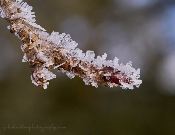
About Today’s Photo:
Yesterday morning, twigs and branches were festooned with glittering ice crystals that sparkled as the sun rose. If you’ve ever wondered what those glittering diamonds look like up close, this is it. When the super cooled moisture suspended in the air meets a catalyst (in this case an apple twig) it forms ice crystals on the catalyst’s surface and we get sparkles.
Panasonic GX8, Olympus 60mm macro lens, ISO 800, f/8, 1/320″ exposure.
Tuesday, December 11, 2018

A fine set of porcupine tracks up at Sleepy Hollow
Morning Observation:
This morning in Huntington at 7:10AM it’s currently a frosty 4 degrees under mostly clear skies. Winds are calm. Relative humidity is 89%, dewpoint 1, barometric pressure 30.18” and steady. We have 8” of snow at the stake. Yesterday’s high was 29, and the overnight low was 2.
Forecast:
Quiet conditions will continue through the end of the work week. We’ll see increasing clouds today as a weak clipper system over the northern Great Lakes shifts eastward. This system will bring periods of light snow tonight into Wednesday morning with just a dusting to an inch expected in most areas. A cold front and associated high pressure will bring more chilly air into the region Wednesday with high temperatures a good 10 to 15 degrees below normal Wednesday and Wednesday night. Temperatures will gradually moderate on Thursday and Friday with highs likely reaching 35 to 40 degrees on Friday. At this point it’s looking like we may see a bit of rain Saturday, but it’s not looking like it will be overly impactful as drier and cooler conditions are expected Sunday.
We’ll see sunny skies this morning giving way to mostly cloudy later in the day. Highs will be near 27 with south winds 3 to 6 mph. Tonight should be cloudy with a 30% chance of snow showers. Lows will be around 18 with calm winds becoming northwesterly around 5 mph after midnight. New snow accumulation of less than a half inch possible.
Wednesday should start out cloudy with a 20% chance of snow showers before early. We should see gradual clearing by the afternoon with a high near 21 and northwest winds 6 to 9 mph. Wednesday night should be clear and chilly with a low around -1 and light and variable winds.
Thursday’s looking sunny with a high near 27 ands south winds 5 to 8 mph.
Thursday night should be mostly cloudy with a low around 20 and south winds around 6 mph.
Almanac:
Last year on this date we had a high of 29 and a low of 13. We picked up 0.5″ of new snow and had 1″ at the stake.
Burlington averages for this date are a low of 21 and a high of 35.
The record low was -13 in 1958.
The record high was 61 in 1966.
Sky Notes:
Sunrise: 7:17AM
Sunset: 4:12PM
Length of day: 8:55:03
Today will be 0:49 shorter than yesterday.
The Moon is a waxing crescent, 3.7 days old with 14.6% illumination.
Moonrise: 10:33AM
Moonset: 8:14PM
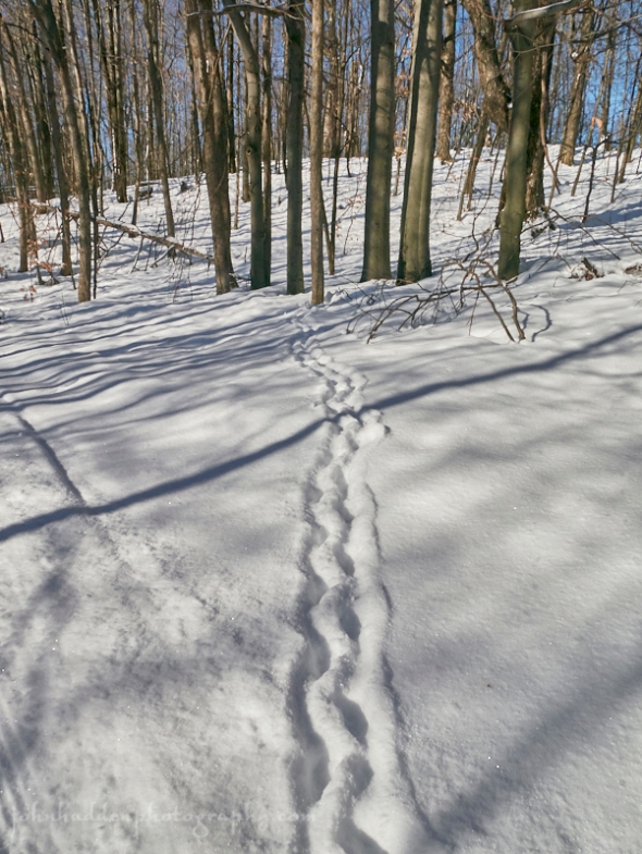
About Today’s Photo:
I came across this fine set of porcupine tracks will skiing up at Sleepy Hollow the other day. The distinctive wiggle to the track is indicative of the porcupine’s short legs and the way it waddles through deeper snow.
Panasonic GM5, Lumix 12-32mm lens @ 12mm, ISO 400, f/14, 1/800″ exposure.
Monday, December 10, 2018

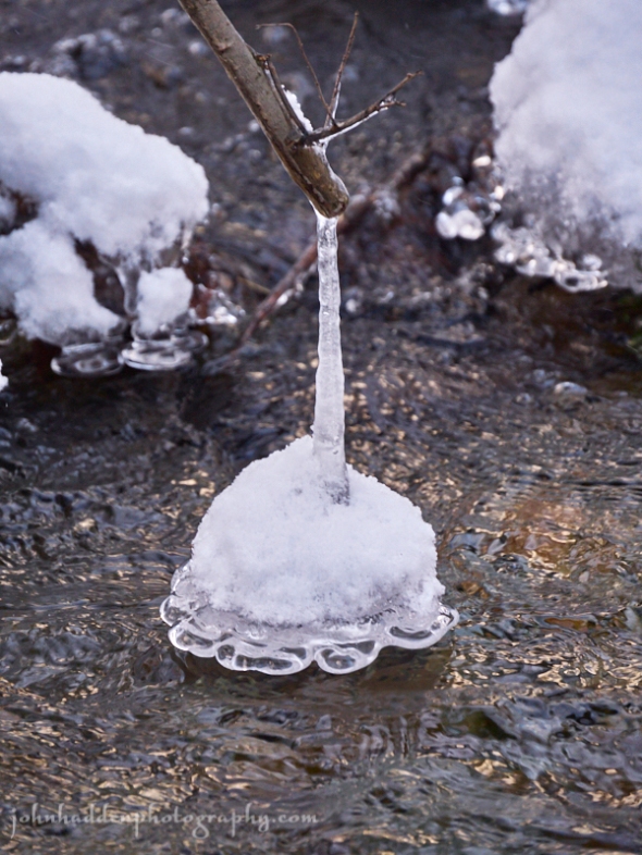
Water flows around a snowy ice-skirted rock in Fargo Brook
Morning Observation:
This morning in Huntington at 7:45AM it’s currently 21 degrees and snowing lightly under overcast skies. Winds are calm. Relative humidity is 84%, dewpoint 17, barometric pressure 30.16” and rising slowly. We’ve picked up just a dusting of new snow and have 8” at the stake. Yesterday’s high was 32, and the overnight low was 21.
Forecast:
We’ve got a mostly dry and quiet day on tap today as high pressure builds into the region. A couple of weak upper level troughs will continue to bring colder than normal temperatures and chances for light snow through mid week. A gradual
warming trend is expected towards the end of the week with temperatures bumping towards 40 on Friday, however the possibility of significant precipitation is looking less likely for the upcoming weekend. We may still see some rain and snow Friday night into Saturday.
We’ll see cloudy skies this morning with gradual clearing this afternoon. Highs will be near 23 with north winds 5 to 7 mph. Tonight should be partly cloudy with a low around 9 and light and variable winds.
Tuesday should be partly sunny with a high near 28 and light and variable winds.
Tuesday night should be mostly cloudy with a low around 14 and light and variable winds.
Wednesday’s looking partly sunny with a high near 18 and north winds 6 to 9 mph.
Wednesday night should be mostly clear with a low around 4 and north winds around 6 mph becoming calm in the evening.
Almanac:
Last year on this date we had a high of 32 and a low of 25. We picked up 0.50″ of snow and had 0.50″ at the stake.
Burlington averages for this date are a low of 21 and a high of 35.
The record low was -9 in 1958.
The record high was 61 in 1966.
Sky Notes:
Sunrise: 7:16AM
Sunset: 4:12PM
Length of day: 8:55:52
Today will be 0:53 shorter than yesterday.
The Moon is a waxing crescent, 2.8 days old with 8.6% illumination.
Moonrise: 9:53AM
Moonset: 7:18PM
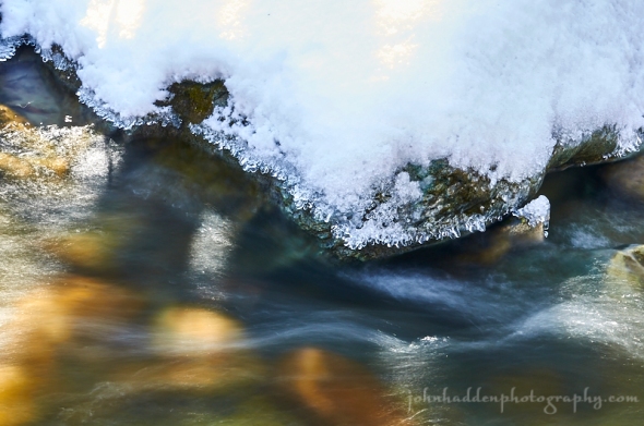
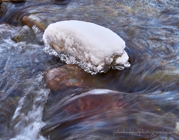
About Today’s Photo:
Frozen water and flowing water combine in this image of motion and stillness in Fargo Brook.
Panasonic GX8, Lumix 14-140mm lens @ 40mm, ISO 200, f/9, 1/15″ exposure.
Sunday, December 9, 2018

A fine view a Camel’s Hump from Sleepy Hollow yesterday
Morning Observation:
This morning in Huntington at 8:20AM it’s currently 18 degrees under mostly cloudy skies. Winds are calm. Relative humidity is 94%, dewpoint 17, barometric pressure 30.35” and falling rapidly. We picked up a dusting of snow overnight and have 8.5” at the stake. Yesterday’s high was 17, and the overnight low was 7.
Forecast:
We’re set for a quiet stretch of weather for the week ahead with relatively dry conditions expected. A couple of weak upper level troughs will move across the region through the middle of the week, but they will only bring light snow showers to the area. Temperatures will remain below normal through Wednesday, with a gradual warming trend anticipated by the end of the week with temperatures edging towards 40 by Friday. The next chance for significant precipitation should arrive Saturday, and at this point it’s looking like the “R” word might make an appearance. Stay tuned.
Today should be mostly sunny with a high near 31 and south winds 8 to 14 mph.
Tonight should bring a slight chance of snow showers. It’ll be mostly cloudy with a low around 19 and southwest winds 6 to 9 mph becoming northwesterly after midnight.
Monday should be partly sunny with a high near 23 and north winds 5 to 8 mph.
Monday night should be partly cloudy with a low around 10 and calm winds becoming southerly around 5 mph after midnight.
Tuesday’s looking mostly cloudy with a high near 24 and south winds around 5 mph becoming calm in the morning. Tuesday night should bring a 30% chance of light snow showers. It’ll be mostly cloudy with a low around 11 and light and variable winds.
Almanac:
Last year on this date we had a high of 33 and a low of 21.
Burlington averages for this date are a low of 22 and a high of 36.
The record low was -9 in 1989.
The record high was 61 in 1966.
Sky Notes:
Sunrise: 7:15AM
Sunset: 4:12PM
Length of day: 8:56:46
Today will be 0:58 shorter than yesterday.
The Moon is a waxing crescent, 2 days old with 4% illumination.
Moonrise: 9:07AM
Moonset: 6:24PM
About Today’s Photo:
With a bluebird day yesterday, the view of Camel’s Hump and the Huntington Valley was lovely from the Butternut Cabin at Sleepy Hollow. Purington’s Christmas tree farm is visible in the center of the image, and the three summits of the Bald Hill complex stretch just to the right of the Hump’s summit.
Panasonic GM5, Lumix 12-32mm lens @ 32mm, ISO 400, f/14, 1/640″ exposure.
Saturday, December 8, 2018

Dangling ice in Fargo Brook
Morning Observation:
This morning in Huntington at 7:45AM it’s currently -4 degrees under clear skies (still not as low as the -5 we dropped down to on November 23rd). Winds are calm. Relative humidity is 87%, dewpoint -7, barometric pressure 30.47” and steady. We picked up a dusting of new snow overnight and have 8.5” at the stake. Yesterday’s high was 30, and the overnight low was -4.
Forecast:
We’ve got a fairly quite forecast ahead for the next several days. High pressure over much of the eastern US will dominate, however, a few weak shortwave troughs will skirt the northern border bringing chances for light snow showers over the weekend and into early next week, as well as reinforcing shots of below normal temperatures. The weather becomes quiet for the middle of next week with a gradual warming trend expected. At this point it looks like and area of low pressure will bring the next chance of significant precipitation next weekend. Stay tuned for precipitation type!
Morning sunshine should give way to clouds later today with 30% chance of snow showers this afternoon. Highs will be near 19 with calm winds becoming westerly around 5 mph. Tonight should bring a 30% chance of snow showers. It’ll be mostly cloudy with a low around 13 and southwest winds 3 to 6 mph. New snow accumulation of less than 1/2″ is possible.
Sunday should be mostly sunny with a high near 30 and south winds 6 to 13 mph.
Sunday night should be mostly cloudy with a low around 20 and southwest winds 7 to 10 mph becoming northwesterly after midnight.
Monday’s looking partly sunny with a high near 23 and northwest winds 6 to 8 mph. Monday night should be partly cloudy with a low around 9 and light north winds.
Almanac:
Last year on this date we had a high of 34 and a low of 23.
Burlington averages for this date are a low of 22 and a high of 36.
The record low was -6 in 1989.
The record high was 58 i 1951.
Sky Notes:
Sunrise: 7:14AM
Sunset: 4:12PM
Length of day: 8:57:44
Today will be 1:02 shorter than yesterday.
The moon is a waxing crescent, 1 day old with 1% illumination.
Moonrise: 8:15AM
Moonset: 5:34PM
About Today’s Photo:
Cold temperatures and moving water make for interesting and fanciful ice formations. Bark peeling off of a fallen tree across Fargo Brook creates a dangling platform for ice to form. The bell shaped balls of ice and snow twisted from side to side above the flowing water.
Panasonic GX8, Lumix 14-140mm lens @ 73mm, ISO 800, f/16, 1/30″ exposure.
Friday, December 7, 2018

Snow dusted winterberry out by our pond
Morning Observation:
This morning in Huntington at 7:35AM it’s currently 22 degrees under partly cloudy skies. Winds are calm. Relative humidity is 82%, dewpoint 17, barometric pressure 30.22” and rising rapidly. We picked up 2.5” of new snow in the past 24hrs and have 9.5” at the stake. Yesterday’s high was 32, and the overnight low was 22.
Forecast:
Any lingering snow showers will come to an end this morning as a cold front
crosses the region and strong high pressure builds into the region. Another shot of colder air will move in behind the front with temperatures dipping into the single digits tonight. A weak trough crossing the region Saturday night may spark a few light mountain snow shower, otherwise conditions will be relatively quiet going into next week with only a slim chance of snow as a series of week clipper systems move through.
Any lingering morning snow will give way to partly sunny skies this afternoon with a temperature falling to around 17 nightfall. Winds will be out of he northwest at 9 to 11 mph. Tonight should be partly cloudy and chilly with lows around 3 and northwest winds 5 to 9 mph becoming light north after midnight.
Saturday should bring a slight chance of afternoon snow showers. It’ll be increasingly cloudy with a high near 19 and calm winds becoming westerly around 5 mph. Saturday night should bring a 40% chance of snow showers before 11:00pm. It’ll be mostly cloudy with a low around 12 and calm winds becoming westerly around 5 mph after midnight. New snow accumulation of less than 1/2″ is possible.
Sunday’s looking mostly sunny with a high near 28 and light southwest winds becoming southerly 5 to 10 mph in the morning. Sunday night should be mostly cloudy with a low around 21 and southwest winds around 6 mph becoming calm.
Almanac:
Last year on this date we had a high of 35 and a low of 32.
Burlington averages for this date are a low of 23 and a high of 36.
The record low was -3 in 1970.
The record high was 67 in 1998 (we had a high of 64).
Sky Notes:
Sunrise: 7:14AM
Sunset: 4:12PM
Length of day: 8:58:47
Today will be 1:06 shorter than yesterday.
The Moon is new, 0 days old with 0% illumination.
Moonrise: 7:17AM
Moonset: 4:49PM
About Today’s Photo:
The winterberry bush out by our pond is nearly stripped of its berries now. This native plant is a favorite of birds at this time of year, and I saw a group of robins feeding in it just the other day.
Thursday, December 6, 2018
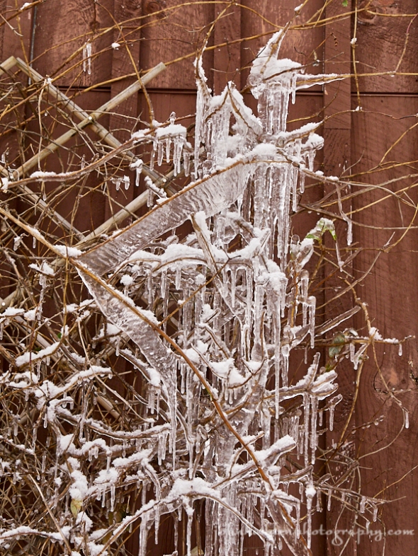
Ribbons of ice form on the bittersweet vine next to the garage door
Morning Observation:
This morning in Huntington at 7:30AM it’s currently 24 degrees under partly cloudy skies. Winds are calm. Relative humidity is 94%, dewpoint 22, barometric pressure 30.03” and steady. We picked up 1” of fluffy snow in the past 24hrs and have 7” at the stake. Yesterday’s high was 29, and the overnight low was 17.
Forecast:
Occasional lake (Ontario) effect snow showers are expected through tonight as a trough of low pressure and accompanying cold front swing through the region. We should see snow accumulations ranging from a dusting to an inch or two in the Champlain and Connecticut River valleys, to 2″ to 6″ with localized higher amounts over the ‘Dacks and portions of the central and northern Greens. High pressure will build in Friday bringing chilly air and dry conditions. A clipper system could deliver a light shot of snow showers Saturday night.
We’ll see snow showers today. Highs will be near 31 with southwest winds 6 to 9 mph. Chance of precipitation is 80% with daytime snow accumulation of less than 1″ likely. Tonight snow showers are likely mainly before 10pm. It’ll be mostly cloudy with a low around 22 and south winds 7 to 9 mph. Chance of precipitation is 60% with snow accumulation of 1″ to 2″ possible.
Friday should bring a 20% chance of snow showers early. It’ll be partly sunny with a high near 23 and northwest winds around 11 mph. Friday night should be partly cloudy and chilly with a low around 4 and northwest winds 5 to 9 mph.
Saturday’s looking mostly sunny with a high near 19 and light and variable winds becoming northwesterly around 5 mph. Saturday night should bring a 40% chance of snow showers before early. It’ll be mostly cloudy with a low around 12 and light and variable winds.
Almanac:
Last year on this date we had a high of 53 and a low of 32. We picked up 0.53″ of rain.
Burlington averages for this date are a low of 23 and a high of 37.
The record low was -3 in 1940.
The record high was 64 in 2001 (we had a high of 63).
Sky Notes:
Sunrise: 7:13AM
Sunset: 4:12P
Length of day: 8:59:53
Today will be 1:10 shorter than yesterday.
The Moon is a waning crescent, 28.6 days old with 1% illumination.
Moonrise: 6:15AM
Moonset: 4:09PM
About Today’s Photo:
Snowmelt dripping from our garage eves creates a fanciful display of icicles and ice ribbons on the bittersweet vine on its trellis against the wall.
Panasonic GX8, Lumix 14-140mm lens @ 40mm, ISO 800, f/8, 1/25″ exposure.
Wednesday, December 5, 2018
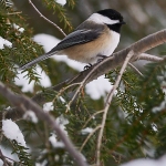
A chickadee in the hemlock by our feeder
Morning Observation:
This morning in Huntington at 7:55AM it’s currently 19 degrees under mostly cloudy skies. Winds are calm. Relative humidity is 93%, dewpoint 17, barometric pressure 30.09” and steady. We picked up just a dusting of snow in the past 24hrs and have 7” at the stake. Yesterday’s high was 29, and the overnight low was 15.
Forecast:
High pressure over the region this morning will slowly slide to the east over the next 12 hours and give way to a slow moving trough of low pressure sliding westward through Ontario and Québec. An accompanying cold front will bring the chance of lake effect snows to the ‘Dacks and northern Greens Thursday night into Friday. Locally we may see an inch or so of fluffy snow. Temperatures will remain on the chilly side going into the weekend with highs near 30 and lows in the low 20s. Friday night we could see temperatures in the single digits above zero.
We’ll see mostly sunny skies today with a high near 29 and light and variable winds. Tonight should bring a 30% chance of snow showers. It’ll be mostly cloudy with a low around 21 and calm winds becoming southerly around 5 mph after midnight.
Thursday should bring a 50% chance of snow showers. It’ll be mostly cloudy with a high near 31 and south winds 7 to 10 mph. New snow accumulation of less than 1/2″ is possible. Thursday night should bring a 40% chance of snow showers. It’ll be cloudy with a low around 19 and south winds 8 to 13 mph becoming westerly after midnight. New snow accumulation of less than 1/2″ is possible.
Friday’s looking partly sunny with a high near 21 and northwest winds 11 to 13 mph. Friday night should be partly cloudy and chilly with a low around 6 and northwest winds around 6 mph becoming calm in the evening.
Almanac:
Last year on this date we had a high of 52 and a low of 39.
Burlington averages for this date are a low of 24 and a high of 37.
The record low was -9 in 1989.
The record high was 65 in 1941.
Sky Notes:
Sunrise: 7:11AM
Sunset: 4:13PM
Length of day: 9:01:04
Today will be 1:14 shorter than yesterday.
The Moon is a waning crescent, 27.6 days old with 4% illumination.
Moonrise: 5:09AM
Moonset: 3:34PM
About Today’s Photo:
Time once again to share a photo of my favorite bird. Well, not this particular bird, but chickadees in general. I really enjoy their gregarious curiosity and general tameness. They are always the first to notice when the feeders are put out in the fall.
Tuesday, December 4, 2018


The effects of snow slump
Morning Observation:
This morning in Huntington at 7:45AM it’s currently 22 degrees and snowing lightly under overcast skies. Winds are out of the west at 0-4 mph. Relative humidity is 85%, dewpoint 18, barometric pressure 29.93” and rising rapidly. We picked up 0.20” of rain and 0.75” of new snow in the past 24hrs. We have 7” of snow at the stake. Yesterday’s high was 43, and the overnight low was 22.
Forecast:
With the passage of yesterday’s cold front, much cooler air has moved into the region, so we’ll see chilly temperatures and a breezy northwest wind today, along with some lingering scattered flurries and mountain snow showers in the morning. High pressure will crest over the region tonight with clearing skies and light terrain driven winds. Clouds will be on the increase Wednesday with additional snow showers arriving on Thursday into Friday ahead of the next cold
front. Temperatures will continue below normal for most of the week, with the coldest day occurring on Friday.
We’ll see a 40% chance of snow showers this morning. It’ll start our cloudy then gradually become mostly sunny with a high near 28 and northwest winds 8 to 11 mph gusting to 23 mph. Tonight should be partly cloudy with a low around 12 and northwest winds 5 to 7 mph becoming calm after midnight.
Wednesday should be mostly sunny with a high near 28 and light and variable winds. Wednesday night should be mostly cloudy with a low around 21 and south winds 3 to 5 mph.
Thursday should bring 30% chance of snow showers in the afternoon. It’ll be mostly cloudy with a high near 32 and south winds 6 to 11 mph. Thursday Night snow is likely. It’ll be cloudy with a low around 19 and southwest winds 5 to 9 mph becoming westerly after midnight. Chance of precipitation is 60%.
Almanac:
Last year on this date we had a high of 44 and a low of 22.
Burlington averages for this date are a low of 24 and a high of 38.
The record low was -20 in 1940.
The record high was 65 in 1982.
Sky Notes:
Sunrise: 7:10AM
Sunset: 4:13PM
Length of day: 9:02:19
Today will be 1:18 shorter than yesterday.
The Moon is a waning crescent, 26.6 days old with 9% illumination.
Moonrise: 4:02AM
Moonset: 3:02PM
About Today’s Photo:
I came across this interesting phenomenon while skiing up at Camel’s Hump Nordic the other day. As the snow settled, the sticky snow created rings that seemed to float above the surrounding snow. Three trees in a line (with a forth tucked in behind) made for an interesting composition I thought.
Panasonic GM5, Lumix 12-32mm lens @ 21mm, ISO 800, f/16, 1/100″ exposure.
Monday, December 3, 2018

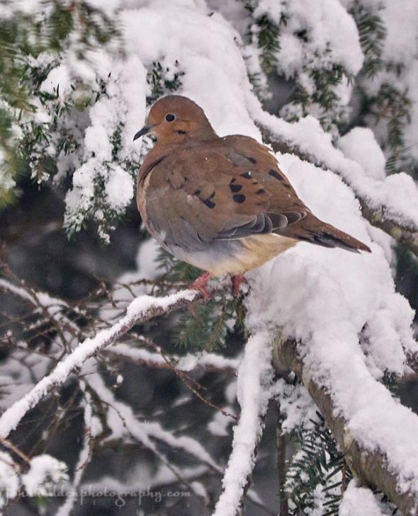
A mourning dove perches in the hemlock by our feeders
Morning Observation:
This morning in Huntington at 7:30AM it’s currently 35 degrees and spitting lightly under overcast skies. Winds are calm. Relative humidity is 97%, dewpoint 35, barometric pressure 29.46” and steady. We picked up 0.30” of rain in the past 24hrs. Snowpack is down to 8.5” at the stake. Yesterday’s high was 44, and the overnight low was 34.
Forecast:
Low pressure tracking northeastward from Lake Ontario through the Saint
Lawrence Valley today will bring some scattered rain showers today. A cold front will follow the passage of the low this afternoon and evening allowing rain showers to transition snow showers over higher terrain tonight with light snow accumulations possible. High pressure will build into the northeastern US Tuesday bringing generally fair though chilly conditions for mid-week.
We’ll see rain showers today with a bit of snow mixed in over higher elevations this afternoon. It’ll be cloudy with temperatures topping out near 42 this morning, then falling to around 34 in the afternoon. Winds will be out of the south at 11 to 15 mph and becoming northwesterly and gusting to 25 mph in the afternoon. Chance of precipitation is 70% with total daytime snow accumulation of less than 1/2″ possible. Tonight snow showers are likely early. It’ll be cloudy with a low around 22 and northwest winds 11 to 13 mph. Chance of precipitation is 60% with snow accumulation of less 1″ possible.
Tuesday should bring a 20% chance of snow showers before 3:00pm. It’ll be mostly cloudy with a high near 25 and northwest winds 9 to 11 mph. Tuesday night should be mostly cloudy with a low around 15 and northwest winds 5 to 7 mph becoming calm after midnight.
Wednesday’s looking mostly sunny with a high near 28 and calm winds. Wednesday night should be mostly cloudy with a low around 21 and calm winds becoming southerly around 5 mph after midnight.
Almanac:
Last year on this date we had a high of 40 and a low of 26.
Burlington averages for this date are a low of 25 and a high of 38.
The record low was -18 in 1940.
The record high was 59 in 2009 (we had a high of 57).
Sky Notes:
Sunrise: 7:09AM
Sunset: 4:13PM
Length of day: 9:03:38
Today will be 1:22 shorter than yesterday.
The Moon is a waning crescent, 25.6 days old with 16% illumination.
Moonrise: 2:54AM
Moonset: 2:33PM
About Today’s Photo:
Mourning doves are in attendance at our feeders again this season. These year-round residents have a somewhat coy disposition, and I’m alway amazed at how long they take to get out of the way when you see them on the roads while driving…
Panasonic GX8, Lumix 100-300mm lens @ 300mm, ISO 1600, f/5.6, 1/400″ exposure.
