Wednesday, February 28, 2018

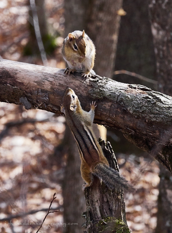
Two chipmunks cavort on “Chipmunk Hill”
Morning Observation:
This morning in Huntington at 8:05AM it’s currently 37 degrees under overcast skies. Winds are calm. Relative humidity is 86%, dewpoint 33, barometric pressure 29.98” and falling slowly. Yesterday’s high was 51, and the overnight low was 31.
Forecast:
Low pressure skirting to our north this morning may bring a few spotty light showers early this morning, along with increasing clouds. A weak frontal boundary will quickly cross the North Country this evening and overnight, bringing more showers. These showers will end by daybreak Thursday as the
front exits the region. The next chance of precipitation will be arrives Thursday night into Friday as a low pressure system from the Midwest moves toward the Mid-Atlantic Coast. At this point the track of this system are uncertain as are the temperature profiles. We may see some snow out of it, we may not… Stay tuned.
We’ll see partly cloudy this morning becoming cloudy during the afternoon with a slight chance of a rain shower. Highs will be around 54F with SSW winds at 10 to 15 mph. Tonight should be cloudy skies with off and on rain showers overnight. Lows will be around 33F with west winds at 5 to 10 mph. Chance of rain is 50%.
Thursday should be cloudy but dry with highs around 43F and north winds at 5 to 10 mph. Thursday night should bring rain showers early changing to mixed rain and snow later at night. Lows will be around 34F with ENE winds at 5 to 10 mph. Chance of precipitation is 70%.
Friday should be windy with periods of rain and snow in the morning changing to mainly rain in the afternoon. Temperatures will remain nearly steady in the mid to upper 30s with NNE winds at 20 to 30 mph. Chance of precipitation is 80% and winds could occasionally gust over 40 mph. Friday night should be cloudy with a few flurries or snow showers possible. Lows will be around 31F with north winds at 10 to 20 mph.
Almanac:
Last year on this date we had a high of 51 and a low of 27. We picked up 0.2″ of rain.
Burlington averages for this date are highs of 34 and lows of 16.
The record high was 55°F in 1903.
The record low was -17°F in 1920.
Sky Notes:
Sunrise: 6:32AM
Sunset: 5:39PM
Length of Visible Light: 12h 5m
Length of Day: 11h 7m
Tomorrow will be 3 minutes 1 seconds longer
The Moon is waxing gibbous, 13 days old with 96% illumination.
Moonrise: 4:10PM
Moonset: 5:46AM
About Today’s Photo:
We went for a bushwhack walk up on the hill above East Street and Delfrate Road yesterday. At the top of the hill we came across at least 7 chipmunks cavorting amongst the fallen trees, logs, and other playground equipment. Lots of chasing and hiding. They were not particularly shy of us either, coming within inches of our feet to investigate.
Chipmunks will spend most of the colder months in a tupor state (as opposed to true hibernation) in solitary burrows, but seeing as we’re not seeming to have any of that “colder” stuff, they’re emerging a bit early to kick off their spring breeding season that runs from late February to April. I’m guessing the concentration of so many of them in one place had to do with breeding and the availability of plenty of mast crops as the beech and oaks on the hill were prolific last fall. We’ve dubbed the hill “Chimpunk Hill”.
Panasonic GX8, Lumix 14-140mm lens @ 125mm, ISO 800, f/9, 1/400″ exposure.
Tuesday, February 27, 2018


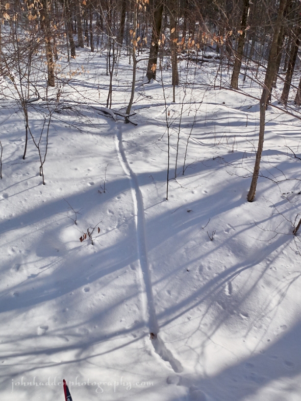
Coyote tracks across a field at Craftsbury
Morning Observation:
This morning in Huntington at 7:45AM it’s currently 24 degrees under clear skies. Winds are calm. Relative humidity is 94%, dewpoint 23, barometric pressure 30.31” and rising slowly. Yesterday’s high was 46, and the overnight low was 23.
Forecast:
High pressure building over the eastern US will keep the North Country dry today with above normal temperatures. A weak low over Canada will bring some clouds later this afternoon along with spotty light precipitation to the higher terrain of northern Vermont and New York tonight. Clouds will increase Wednesday as a weak frontal boundary to our north will spread bring light snow and rain across mainly the far north. The next chance for precipitation will be Thursday night into Friday as a low pressure system moves from the Midwest to the Mid Atlantic Coast. We may see a bit of snow out of this one…
We’ll see sunshine with a few afternoon clouds today. Highs will be around 47F with SW winds at 10 to 15 mph. Tonight should be partly cloudy early giving way to cloudy skies late with a slight chance of a shower late. Lows will be around 35F with SW winds at 10 to 20 mph.
Wednesday should be mostly cloudy with a slight chance of a rain shower. Highs will be around 49F with SSW winds at 5 to 10 mph. Wednesday night should be cloudy with lows around 32F and light and variable winds.
Thursday’s looking cloudy with high around 39F and NNW winds at 5 to 10 mph. Thursday night should bring intermittent light snow or snow showers becoming steadier late at night. Lows will be around 31F with NNE winds at 5 to 10 mph. Chance of snow is 70% with about 1″ of snow expected.
Almanac:
Last year on this date we had a high of 43 and a low of 28. We picked up 0.15″ of rain and were back down to bare ground at the stake.
Burlington averages for this date are highs of 34 and lows of 16.
The record high was 57°F in 2000 (we had a high of 61).
The record low was -21°F in 1963.
Sky Notes:
Sunrise: 6:34AM
Sunset: 5:38PM
Length of Visible Light: 12h 2m
Length of Day: 11h 4m
Tomorrow will be 3 minutes 1 seconds longer
The Moon is waxing gibbous, 11.8 days old with 90% illumination.
Moonrise: 2:57PM
Moonset: 4:59AM
About Today’s Photo:
It’s still winter up in Craftsbury where I was delighted to find plenty of snow to ski yesterday at the Craftsbury Outdoor Center. These tracks tell the story of a coyote cruising across the field in the early morning.
Panasonic GM5, Lumix 12-32mm lens @ 12mm, ISO 200, f/16, 1/1300″ exposure.
Monday, February 26, 2018


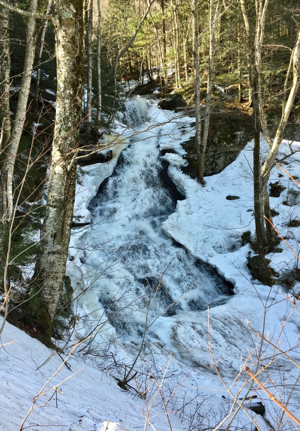
Ice and water flow in Fargo Brook
Morning Observation:
This morning in Huntington at 7:50AM it’s currently 29 degrees under partly cloudy skies. Winds are calm. Relative humidity is 96%, dewpoint 28, barometric pressure 30.04” and rising slowly. We picked up a dusting of snow and sleet and 0.06” of melted precipitation/rain. Yesterday’s high was 41, and we had a top wind gust of 34mph. The overnight low was 27.
Forecast:
High pressure will build across the region today into Tuesday bringing dry weather, more sunshine, and continued above normal temperatures. The next chance for precipitation arrives Wednesday with a weak frontal passage. A potentially more potent system might be in the cards for Friday, but it’s too soon to say what we might get from it.
We’ll see mostly sunny skis today with highs around 44F and west winds at 10 to 20 mph. Tonight should be mostly clear with lows around 27F and west winds at 5 to 10 mph.
Tuesday should be sunny with highs around 48F and SW winds at 10 to 15 mph. Tuesday night should be partly to mostly cloudy with lows around 36F and SW winds at 10 to 15 mph.
Wednesday’s looing mostly cloudy with a chance of a rain shower. Highs will be around 50F with WSW winds at 5 to 10 mph. Wednesday night should be mostly cloudy early followed by a mixture of light rain and snow overnight. Lows will be around 33F with light and variable winds. Chance of precipitation is 70%.
Almanac:
Last year on this date we had a high of 34 and a low of 20. We picked up 1″ of snow and had 1″ at the stake.
Burlington averages for this date are highs of 34 and a low of 15.
The record high was 60°F in 1957
The record low was -19°F in 1970.
Sky Notes:
Sunrise: 6:35AM
Sunset: 5:36PM
Length of Visible Light: 11h 59m
Length of Day: 11h 0m
Tomorrow will be 3 minutes 0 seconds longer
The Moon is waxing gibbous, 10.7 days old with 82% illumination.
Moonrise: 1:48PM
Moonset: 4:06AM
About Today’s Photo:
I never tire of playing with water and trying to capture different aspects of its flow using different shutter speeds. I’ve found that speeds of around 1/300″ seem to capture the liquidity of water nicely. The ice gives the eye something solid to hold on to.
Panasonic GX8, Olympus 60mm macro lens, ISO 400, f/8, 1/320″ exposure.
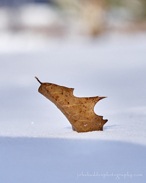
Saturday, February 24, 2018

A bent stem drops its snow load
Morning Observation:
This morning in Huntington at 7:50AM it’s currently 35 degrees under mostly
cloudy skies. Winds are calm. Relative humidity is 97%, dewpoint 34, barometric pressure 30.12” and rising slowly. We picked up 0.10” of rain in the past 24hrs. Bare ground at the stake. Yesterday’s high was 39, and the overnight low was 34.
Forecast:
High pressure building into the region this morning will deliver a quiet and dry day today with some clearing skies tonight. Low pressure moving out of the Great Lakes will lift a warm front through the region Sunday bringing another round of snow, mixed precipitation, and rain Sunday along with gusty southeasterly downslope winds especially along the western slopes of the Greens. High pressure builds back in Monday. The above normal temperature trend will continue through the next 7 days.
We’ll see mostly cloudy skies today with highs near 40F and NW winds at 5 to 10 mph. Tonight should be partly cloudy with lows around 29F and east winds at 10 to 15 mph.
Sunday should bring a wintry mix in the morning changing to rain showers in the afternoon. Highs will be around 38F with SE winds at 20 to 30 mph. Chance of precipitation is 100% with snow and ice accumulations of 1″ to 3″. Sunday night should be cloudy early followed by partial clearing. Lows will be around 32F with south winds at 10 to 20 mph.
Monday’s looking mostly sunny with highs near 45F and WSW winds at 10 to 15 mph. Monday night should be mostly clear with lows around 27F and west winds at 5 to 10 mph.
Almanac:
Last year on this date we had a high of 50 and a low fo 32. We picked up 0.20″ of rain and were down to bare ground at the stake.
Burlington averages for this date are highs of 33 and lows of 15.
The record high was 55°F in 1930.
The record low was -19°F in 2015 (we had a low of -20).
Sky Notes:
Sunrise: 6:39AM
Sunset: 5:34PM
Length of Visible Light: 11h 53m
Length of Day: 10h 54m
Tomorrow will be 2 minutes 59 seconds longer
The Moon is waxing gibbous, 8.5 days old with 61% illumination.
Moonrise: 11:49AM
Moonset: 2:00AM
About Today’s Photo:
Back when there was snow on the ground (remember that?) this bent stem caught my eye. I like the way the light snow load on it had fallen to create a complementary arch.
Panasonic GX8, Lumix 14-140mm lens @ 40mm, ISO 400, f/9, 1/1300″ exposure.
Friday, February 23, 2018

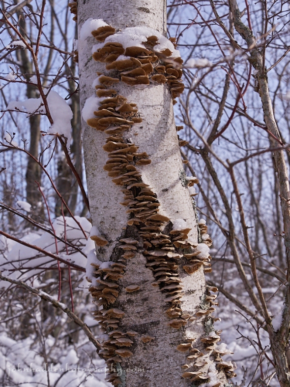
An interesting pattern of fungus on a birch
Morning Observation:
This morning in Huntington at 8:15AM it’s currently 24 degrees under mostly clear skies. Winds are calm. Relative humidity is 93%, dewpoint 22, barometric pressure 30.61” and falling rapidly. Yesterday’s high was 32, and the overnight low was 17.
Forecast:
We’ve got an active period of weather on tap starting today and lasting through the upcoming weekend as two shortwave troughs swing through delivering a mixed bag of precipitation. The first system impacts our region this afternoon with the second on Sunday as the above normal temperatures trend continues. Minor ice accumulation could be seen in eastern and central Vermont this afternoon and could produce a few slick spots during the evening commute. Gusty southeast downslope winds along the western slopes of the Greens are possible on Sunday.
We’ll see cloudy skies with rain developing this afternoon with some mixed precipitation possible before the changeover. Highs will be around 40F wiht SSE winds at 10 to 20 mph. Chance of rain is 90%. Tonight should be cloudy with occasional rain showers. Lows will be around 36F with SW winds at 15 to 25 mph. Chance of rain is 60%.
Saturday should be cloudy early with partial sunshine expected later in the day. Highs will be around 39F with NW winds at 10 to 15 mph. Saturday night should be partly cloudy with low around 29F and east winds at 10 to 15 mph.
Sunday’s looking windy with a wintry mix in the morning changing to rain showers in the afternoon. Highs will be around 38F with SE winds at 20 to 30 mph. Chance of precipitation is 100% with 1″ to 3″ of snow and ice expected before the changeover. Sunday night should be cloudy early becoming partly cloudy later at night. Lows will be around 33F with south winds at 10 to 15 mph.
Almanac:
Last year on this date we had a high of 64 and a low of 35. We were down to bare ground at the stake.
Burlington averages for this date are highs of 33 and lows of 14.
The record high was 63°F in 2017 (we had a high of 64).
The record low was -22°F in 1972.
Sky Notes:
Sunset: 6:40AM
Sunset: 5:32PM
Length of Visible Light: 11h 50m
Length of Day: 10h 52m
Tomorrow will be 2 minutes 59 seconds longer
The Moon is in its first quarter, 7.4 days old with 50% illumination.
Moonrise: 11:02AM
Moonset: 12:52AM
About Today’s Photo:
While exploring up in the Missisquoi National Wildlife Management Area the other day, we came across this interesting patterning of fungus on a birch.
Panasonic GX8, Lumix 14-140mm lens @ 26mm, ISO 640, f/7.1, 1/1300″ exposure.
Thursday, February 22, 2018

Snow melt pours down the mountain at Mad River Glen yesterday
Morning Observation:
This morning in Huntington at :40AM it’s currently 27 degrees under mostly cloudy skies. Winds are calm. Relative humidity is 72%, dewpoint 19, barometric pressure 30.64” and rising slowly. We picked up 0.05” of rain in the past 24hrs and are down to bare ground at the snow stake. Yesterday’s high made it up to 70, and the overnight low was 27.
Forecast:
Cloud cover will increase today as a weak shortwave trough brings a chance of snowfall to southern Vermont this afternoon. Clouds will then decrease through the overnight hours allowing temperatures to drop and return to near seasonal norms. Another shortwave trough will approach the region Friday and temperatures will quickly to near 40. Precipitation will build across the region late Friday morning with a transition from snow to sleet to rain expected. There’s not much moisture to work with so no real impacts are expected with this system as it quickly exits the region Friday night. High pressure builds in for Saturday. In general, temperatures are expected to be above seasonal averages for the foreseeable future…
We’ll see mostly cloudy skies today with highs around 30F and light and variable winds. Tonight should be clear with lows around 21F and light and variable winds.
Friday should start out partly cloudy in the morning then become cloudy with a mix of rain and snow later in the day. Some mixed winter precipitation is possible. Highs will be around around 40F with SSE winds at 10 to 20 mph. Chance of precipitation is 90%. Friday night should be cloudy with occasional rain showers. Lows will around 36F with SW winds at 10 to 20 mph. Chance of rain is 50%.
Saturday’s looking cloudy with highs around 39F and NW winds at 5 to 10 mph. Saturday night should be mostly cloudy with lows around 30F and east winds at 10 to 15 mph.
Almanac:
Last year on this date we had a high of 58 and a low of 33. We were out of town so I have unreliable precipitation data.
Burlington averages for this date are highs of 32 and lows of 14.
The record high was 61°F in 1981 (Burlington set a new high of 69 for yesterday’s date).
The record low was -20°F in 1963.
Sky Notes:
Sunrise: 6:42AM
Sunset: 5:31PM
Length of Visible Light: 11h 47m
Length of Day: 10h 49m
Tomorrow will be 2 minutes 58 seconds longer
The Moon is a waxing crescent, 6.3 days old with 38% illumination.
Moonrise: 10:22AM
No Moonset
About Today’s Photo:
Record high temperatures wreaked havoc the snowpack yesterday. Those of us skiing at Mad River Glen yesterday were commenting on how it was like April ski conditions in February. One of the waterfalls along the trails was gushing water and the sound of running water was ubiquitous.
iPhone 6S
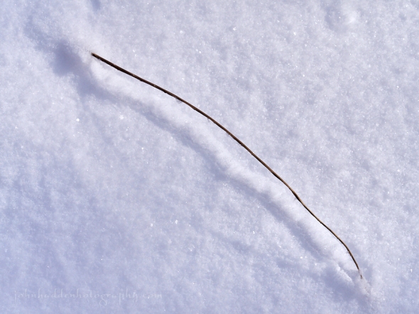
Wednesday, February 21, 2018

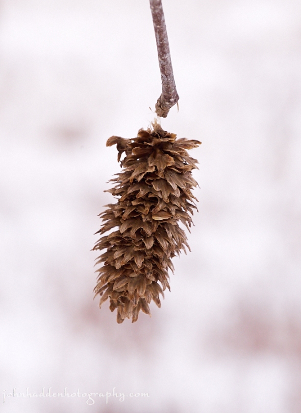
A birch cone dangles by a thread
Morning Observation:
This morning in Huntington at 7:05AM it’s currently 45 degrees under partly cloudy skies. Winds are calm. Relative humidity is 95%, dewpoint 44, barometric pressure 30.11” and falling slowly. We picked up 0.11” of rain in the past 24hrs and are down to about 1/5” of ice-ish cover at the stake. Yesterday’s high was 50, and the overnight low was 41, and the overnight high was 58 at 3:30AM!
Forecast:
Record breaking warm temperatures are expected today which will cause significant snow melt and sharp rises on local streams and rivers. Areas of ice jam flooding are possible through Wednesday night. An Areal Flood Watch remains in effect for our region. Scattered rain showers will pop up this afternoon as a cold front pushes through the region allowing temperatures to drop back into the 20s and 30s tonight with drier conditions expected on Thursday. Friday will bring a renewed chance for some like snow or mixed precipitation in the afternoon. Long term forecasts are calling for above normal temperatures well into next week. Wherefore art thou Winter?
Morning sunshine will give way to rain for the afternoon. Record high temperatures are expected with highs near 65F and WSW winds at 10 to 20 mph. Chance of rain is 80%. Tonight should be partly cloudy and cooler with lows around 23F and NNW winds at 10 to 15 mph.
Thursday should be cloudy with high near 30F and light and variable winds. Thursday night should be partly cloudy with low around 22F and light and variable winds.
Friday’s looking partly cloudy skies during the morning hours, giving way to cloudy skies with a mix of rain and snow developing in the afternoon. Highs will be around 38F with SSE winds at 10 to 15 mph. Chance of precipitation is 70%. Friday night rain showers early will mix with snow showers late. Lows will be around 32F with SW winds at 10 to 15 mph. Chance of precipitation is 60%.
Almanac:
Last year on this date we had a high of 47 and a low of 12. We picked up 2″ of new snow and had 9″ at the stake.
Burlington averages for this date are highs of 32 and lows of 14.
The record low was 59°F in 1981.
The record low was -19°F in 1950.
Sky Notes:
Sunrise: 6:44AM
Sunset: 5:30PM
Length of Visible Light: 11h 45m
Length of Day: 10h 46m
Tomorrow will be 2 minutes 57 seconds longer
The Moon is a waxing crescent, 5.3 days old with 28% illumination.
Moonrise: 9:48AM
Moonset: 11:44PM
About Today’s Photo:
A birch cone dangles by a thread from a branch on the tree at the edge of our front field.
Panasonic GX8, Olympus 60mm macro lens, ISO 800, f/8, 1/400″ exposure.
Tuesday, February 20, 2018

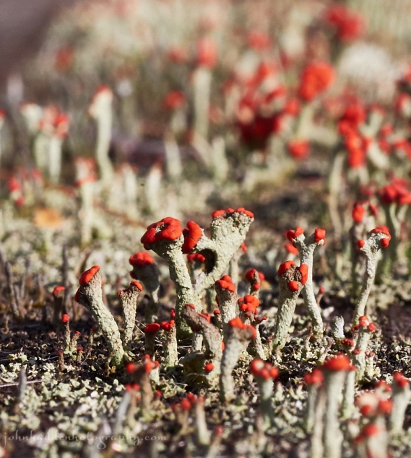
A phalanx of British Soldier lichen on our back deck
Morning Observation:
This morning in Huntington at 7:15AM it’s currently 40 degrees and drizzling under overcast skies. Winds are calm. Relative humidity is 97%, dewpoint 39, barometric pressure 30.16” and steady. We picked up 0.06” of rain overnight and have 4” of snow at the stake. Yesterday’s high was 46, and the overnight low was 37.
Forecast:
The thaw is underway… Low pressure over the Great Lakes this morning is conspiring with a large stationary ridge of high pressure off the Atlantic coast near Bermuda to funnel warm, moist Gulf Coast air into New England. We’ll see unseasonably warm, near record-setting temperatures across the area through Wednesday along with periods of showers or light rain. There’s an areal flood watch in effect for our region through Wednesday as rapid snowmelt is expected. A cold front will swing south through the area Wednesday evening with cooler temperatures and perhaps some lingering snow showers. An active weather pattern continues into the upcoming weekend with renewed chances for light rains and snows.
We’ll see rain early this morning with cloudy skies and showers in the afternoon. Highs will be around 54F with SSW winds at 10 to 15 mph. Chance of rain is 80%. Tonight should bring rain showers with overcast skies overnight. Lows will be around 54F with SSW winds at 10 to 20 mph. Chance of rain is 50%.
Wednesday should be partly cloudy during the morning hours giving way to cloudy skies and rain in the afternoon. Record high temperatures are expected with highs around 65F and SW winds at 10 to 20 mph. Temperatures will drop noticeably in the evening with the arrival of the aforementioned cold front. Chance of rain is 70%. Wednesday night should be clear to partly cloudy. Lows will be around 24F with NNW winds at 10 to 15 mph.
Thursday’s looking cloudy with highs around 31F and light and variable winds. Thursday night should be clear with lows around 23F and light and variable winds.
Almanac:
Last year on this date we had a high of 36 and a low of 15.
Burlington averages for this date are highs of 32 and lows of 14.
The record high was 58°F in 1981.
The record low was -13°F in 1950.
Sky Notes:
Sunrise: 6:45AM
Sunset: 5:28PM
Length of Visible Light: 11h 42m
Length of Day: 10h 43m
Tomorrow will be 2 minutes 56 seconds longer
The Moon is a waxing crescent, 4.3 days old with 19% illumination.
Moonrise: 9:17AM
Moonset: 10:36PM
About Today’s Photo:
One of the white cedar boards on our deck has been overun by bright British Soldier lichens (Cladonia cristatella). The vibrant crimson heads certainly catch the eye!
Panasonic GX8, Olympus 60mm macro lens, ISO 800, f/14, 1/250″ exposure.
Monday, February 19, 2018


Ice and flowing water in Fargo Brook
Morning Observation:
This morning in Huntington at 7:45AM it’s currently 35 degrees under partly cloudy skies. Winds are out of the the south at 2-4 mph. Relative humidity is 62%, dewpoint 23, barometric pressure 30.38” and falling. We have 6.5” of snow at the stake. Yesterday’s high was 36, and the overnight low was 18.
Forecast:
We’re on the cusp of a big warm up… Periods of showers and steadier rainfall will develop later today into Wednesday as a strong warm front lifts through the
region bringing near record-breaking warmth for Tuesday and especially on Wednesday. River ice breakup and potential flooding are strong possibilities so the National Weather Service has issued an Areal Flood Watch from late tonight through Wednesday evening. A cold front will move through Wednesday night into Thursday allowing temperatures trend cooler into next weekend, though remain well above late February norms. Additional precipitation will move into the
area by next weekend.
We’ll see partly cloudy skies early then becoming cloudy with periods of rain this afternoon. Highs will be around 43F with south winds at 15 to 25 mph. Chance of rain is 80%. Tonight should bring periods of rain. Lows will be around 41F with SSW winds at 10 to 15 mph. Chance of rain is 90% with rainfall near a quarter of an inch.
Tuesday should bring a steady rain in the morning with showers continuing in the afternoon. Highs will be around 54F with SSW winds at 10 to 20 mph. Chance of rain is 90% with rainfall around a quarter of an inch. Tuesday night rain showers in the evening should become more intermittent overnight. Lows will be around 53F with SSW winds at 10 to 20 mph. Chance of rain is 60%.
Wednesday should be partly cloudy in the morning with increasing clouds and periods of showers later in the day. Record high temperatures are expected with highs around 63F and SW winds at 10 to 20 mph. Chance of rain is 60%. Wednesday night evening clouds should give way to clearing. Lows will be around 24F with NNW winds at 10 to 15 mph.
Almanac:
Last year on this date we had a high of 51 and a low of 30. We had 12″ of snow at the stake.
Burlington averages for this date are highs of 32 and lows of 13.
The record high was 62°F in 1981.
The record low was -23°F in 1944.
Sky Notes:
Sunrise: 6:47AM
Sunset: 5:27PM
Length of Visible Light: 11h 39m
Length of Day: 10h 40m
Tomorrow will be 2 minutes 56 seconds longer
The Moon is a waxing crescent, 3.3 days old with 12% illumination.
Moonrise: 8:48AM
Moonset: 9:30PM
About Today’s Photo:
I never tire of studying the way water flows and the different ways you can capture it with a camera. Adjusting shutter speed is akin to choosing a different brush as it allows for a wide range of effects in moving water. Here a 1/10″ shutter speed allows the water to blur just a bit while shooting towards the sunlight allows reflection highlights to create “light squiggles” across the surface. A shutter speed of 1/300″ would create an entirely different scene.
Panasonic GX8, Olympus 60mm macro lens, ISO 125, f/18, 1/10″ exposure.
Sunday, February 18, 2018

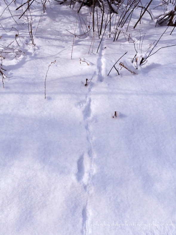
Evidence of a hunt…
Morning Observation:
This morning in Huntington at 7:25AM it’s currently 27 degrees under mostly cloudy skies. Winds are calm. Relative humidity is 92%, dewpoint 25, barometric pressure 30.11” and rising rapidly. We picked up 3” of new snow and 7.75” at the stake. Yesterday’s high was 33, and the overnight low was 27.
Forecast:
Light snow across portions of the region this morning will quickly end as low pressure off the southern New England coast pulls offshore and high pressure begins to build in. Drier conditions will develop for this afternoon and tonight before a significant warming trend is expected Monday through Wednesday of next week, along with periods of rain. Record high temperatures are possible Tuesday and Wednesday, with highs well into the 50s and possibly lower 60s.
We’ll see a mix of clouds and sun early followed by cloudy skies this afternoon. Highs will be around 36F with WNW winds at 10 to 15 mph. Tonight should be partly cloudy with lows around 25F and south winds at 10 to 15 mph.
Monday should be partly cloudy skies with a few rain showers developing later in the day. Highs will be around 45F with south winds at 15 to 25 mph. Chance of rain is 30%. Monday night should be cloudy with periods of rain. Lows will be around 42F with SSW winds at 10 to 15 mph. Chance of rain is 90% with rainfall near a quarter of an inch.
Tuesday rain is likely. Highs will be around 53F with south winds at 10 to 15 mph. Chance of rain is 90% with rainfall near a quarter of an inch. Tuesday night should bring rain showers early with overcast skies late. Lows will be around 53F with SSW winds at 10 to 15 mph. Chance of rain is 40%.
Almanac:
Last year on this date we had a high of 54 and a low of 11. We had 15.5″ of snow at the stake.
Burlington averages for this date are highs of 31 and lows of 13.
The record high was 58°F in 1981.
The record low was -25°F in 1979.
Sky Notes:
Sunrise: 6:48AM
Sunset: 5:25PM
Length of Visible Light: 11h 36m
Length of Day: 10h 37m
Tomorrow will be 2 minutes 55 seconds longer
The Moon is a waxing crescent, 2.3 days old with 6% illumination.
Moorise: 8:20AM
Moonset: 8:24PM
About Today’s Photo:
We took a little expedition up to East Swanton yesterday in hopes of spotting one of the snowy owls that had been sighted in the area over the past several weeks. No luck. However, we did take a nice walk near the Maquam Bog in the Missisquoi Wildlife Refuge and came across some interesting tracks. This set tells the story of a deer or white-footed mouse hopping across the trail with a long-tailed weasel or ermine close on its heels. Was the weasel successful?
Panasonic GX8, Lumix 14-140mm lens @ 19mm, ISO 400, f/9, 1/1000″ exposure.
Saturday, February 17, 2018

A sensitive fern seed frond emerging from the ice
Morning Observation:
This morning in Huntington at 8:00AM it’s currently 9 degrees under clear skies. Winds are calm. Relative humidity is 90%, dewpoint 7, barometric pressure 30.37” and rising. We picked up 0.02” of rain, a thin layer of glaze and 1.5” of snow, and have 5” at the stake. Yesterday’s high was 40, and the overnight low was 7.
Forecast:
High pressure building into the Northeast this morning will provide us with tranquil weather conditions for the first half of the weekend with plentiful sunshine and highs in the low to mid 30s. Tonight, an area of low pressure moving well southeast of New England will bring light snow to mainly eastern and southern portions of Vermont with light accumulations likely. A significant warming trend is expected Monday through Wednesday of next week, along with increasing chances for rain. Near record highs are possible Tuesday into Wednesday, with highs well into the 50s and possibly lower 60s.
We’ll see sunny skies this morning becoming cloudy during the afternoon. Highs will be around 33F with south winds at 5 to 10 mph. Tonight should bring snow showers early south and east of the Greens, with a steadier snow developing late. Lows will be near 25F with SSW winds at 10 to 15 mph. Chance of snow is 80% with snow accumulations of 1″ to 3″ mostly in Rutland and Windsor counties.
Sunday should start out mostly cloudy then become partly cloudy in the afternoon. Highs will be around 36F with WNW winds at 10 to 15 mph. Sunday night should be mostly clear with lows around 24F and south winds at 5 to 10 mph.
Monday’s should start out mostly sunny in the morning then becoming cloudy with periods of rain later in the day. Highs will be around 43F with south winds at 10 to 20 mph. Chance of rain is 70%. Monday night rain is likely. Lows will be around 40F with south winds at 10 to 15 mph. Chance of rain is 90% with rainfall near a half an inch.
Almanac:
Last year on this date we had a high of 33 and a low of 10. We picked up 4.5″ of new snow and had 20″ at the stake.
Burlington averages for this date are highs of 31 and lows of 13.
The record high was 53°F in 1981.
The record low was -21°F in 1963.
Sky Notes:
Sunrise: 6:50AM
Sunset: 5:24PM
Length of Visible Light: 11h 33m
Length of Day: 10h 34m
Tomorrow will be 2 minutes 54 seconds longer
The Moon is a waxing crescent, 1.4 days old with 2% illumination.
Moonrise: 7:52AM
Moonset: 7:20PM
About Today’s Photo:
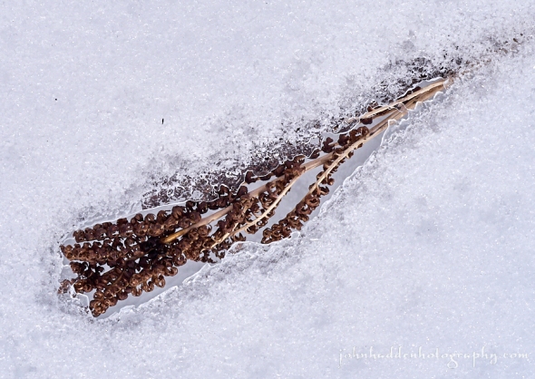
Freeze-thaw, freeze-thaw, freeze-thaw… Seems to be our lot this winter. This sensitive fern seed frond emerges from the ice.
Panasonic GX8, Olympus 60mm macro lens, ISO 800, f/13, 1/200″ exposure.
Friday, February 16, 2018

A quintet of birch seed “cones” in the snow
Morning Observation:
This morning in Huntington at 8:20AM it’s currently 36 degrees under overcast skies. Winds are calm. Relative humidity is 91%, dewpoint 33, barometric pressure 29.58” and steady. We picked up a 0.01” trace of rain in the past 24hrs and have 4” of snow at the stake. Yesterday’s high was 51, and the overnight low was 35.
Forecast:
A cold front is poised to move into the region later this morning allowing for some light snow to develop mainly over the mountains by midday. Any snow accumulations will range from a dusting in the Champlain Valley to 2″ in northern mountains. High pressure will build in tonight bringing clearing skies, dry conditions, and chilly overnight temperatures. Saturday should be mostly sunny and seasonable. A low pressure system will pass to our south Saturday night into Sunday bringing the chance of some light snow to the area especially over southern areas where maybe 2″-3″ of snow may fall with lesser amounts north. A warmer and wetter weather pattern is expected for the first half of next week. Alas…
We’ll see cloudy skies today with snow showers developing this afternoon. Morning high of 39F will fall to near 25 with the arrival of the aforementioned cold front. Winds will be NNW at 10 to 15 mph. Chance of snow is 60% with just a disting expected in valley locations and perhaps 2″ in northern mountains. Tonight should be partly cloudy with low near 10F and NW winds at 10 to 15 mph.
Saturday should be mostly sunny with highs around 32F and south winds at 5 to 10 mph. Saturday night should be cloudy with light snow likely after midnight. Lows will be around 26F with south winds at 10 to 15 mph. Chance of snow is 70% with snow accumulations of less than 1″.
Sunday’s looking mostly cloudy early, then partly cloudy in the afternoon. Highs will be around 38F with west winds at 10 to 15 mph. Sunday night should be mostly clear with lows around 27F and south winds at 5 to 10 mph.
Almanac:
Last year on this date we had a high of 26 and a low of 21. We picked up 6.75″ of new snow and had 13″ at the stake.
Burlington averages for this date are highs of 31 and lows of 13.
The record high was 55°F in 2016 (we had a high of 51).
The record low was -26°F in 1943.
Sky Notes:
Sunrise: 6:51AM
Sunset: 5:23PM
Length of Visible Light: 11h 31m
Length of Day: 10h 31m
Tomorrow will be 2 minutes 53 seconds longer
The Moon is a waxing crescent, 0.2 days old with 0.5% illumination.
Moonrise: 7:22AM
Moonset: 6:17PM
About Today’s Photo:
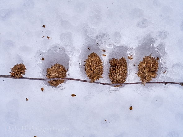
It was a prolific fall for many cone bearing trees including the birch at the edge of our front field. I’ve been seeing the trident shaped seeds on the snow everywhere in the wood this winter. The seeds are an important source of food for many species of birds and rodents.
Panasonic GX8, Olympus 60mm macro, ISO 800, f/8, 1/400″ exposure.
Thursday, February 15, 2018

Light, ice, and water in Fargo Brook
Morning Observation:
This morning in Huntington at 7:30AM it’s currently 32 degrees under mostly cloudy skies. Winds are calm. Relative humidity is 97%, dewpoint 32, barometric pressure 29.84” and falling slowly. We have 6” of snow hanging in there at the stake. Yesterday’s high was 41, and the overnight low was 25.
Forecast:
A southerly airflow will continue to deliver above normal temperatures across the region today and into Friday before a cold front swings through late Friday night into Saturday. Today should be relatively dry with just a few rain showers possible especially over northern New York. Better chances for rain showers will exist tonight over the southern half of Vermont. Not much moisture to work with here so snowpack impacts should be light. Colder air moving in across our northern areas on Friday night will bring some snow in the mountains with a couple of inches possible along with chilly temperatures. High pressure is set to move in over the weekend with another warming trend on the way Sunday into the middle of next week.
We’ll see mostly cloudy skies today with a slight chance of a rain shower. Highs will be around 47F with SSW winds at 10 to 20 mph. Tonight should be mostly cloudy with some fog developing late. Lows will be near 35F with WSW winds at 10 to 15 mph.
Friday any snow during the morning will transition to scattered snow showers during the afternoon. Morning highs of 37F will fall to near 25 with NW winds at 10 to 20 mph. Chance of snow is 70% with snowfall around 1″. Friday night should be partly cloudy and chilly with lows around 6F and NNW winds at 10 to 15 mph.
Saturday should bring some sun in the morning with increasing clouds during the afternoon. Highs will be around 28F with SSE winds at 5 to 10 mph. Saturday night should be overcast with lows around 23F and south winds at 10 to 15 mph.
Almanac:
Last year on this date we had a high of 39 and a low of 24. We had 12″ of snow at the stake.
Burlington averages for this date are highs of 31 and lows of 12.
The record high was 54°F in 2006 (we had a high of 54).
The record low was -26°F in 1943.
Sky Notes:
Sunrise: 6:53AM
Sunset: 5:21PM
Length of Visible Light: 11h 28m
Length of Day: 10h 28m
Tomorrow will be 2 minutes 52 seconds longer
The Moon is new, 29 days old with 0% illumination.
Moonrise: 6:50AM
Moonset: 5:15PM
About Today’s Photo:
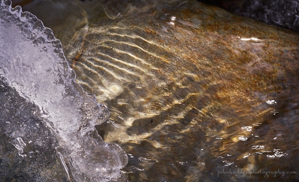
Sunlight spills through running water to paint evocative ripples on a stone in Fargo Brook. I like playing with shutter speeds and water. This image is kind of on the cusp of ripples and blur with strong bands of ripple to the left and a bit of “cellophane squiggle” on the lower right.
Panasonic GX8, Olympus 60mm macro lens, ISO 800, f/14, 1/125″ exposure.
Wednesday, February 14, 2018

Icicles along the edge of our chicken coop roof
Morning Observation:
This morning in Huntington at 7:25AM it’s currently 31 degrees under overcast skies. Winds are out of the south at 0-3 mph. Relative humidity is 62%, dewpoint 19, barometric pressure 30.25” and falling slowly. We have 6” of snow at the stake. Yesterday’s high was 29, and the overnight low was 28.
Forecast:
High pressure will depart to our east this morning and set us up for a warming
trend heading towards the weekend as a southwesterly air flow sets up ahead of an approaching cold front. By Thursday evening we should start to see some lightly scattered rain showers moving over the region as the aforementioned cold front swings through the region on Friday. There’s not a whole lot of moisture to work with so rainfall impacts should be slight with the bulk of the precipitation falling south. High pressure will build in briefly for Saturday bringing clearing skies and seasonable temperatures before a shortwave trough moves through Saturday night into Sunday bringing the chance of some snow.
We’ll see cloudy skies this morning becoming partly cloudy this afternoon. Highs will be around 40F with SSW winds at 10 to 20 mph. Tonight should be partly cloudy and mild with lows around 34F and SSW winds at 10 to 15 mph.
Thursday should be cloudy with a slight chance of a rain shower during the afternoong. Highs will be around 46F with SSW winds at 10 to 15 mph. Thursday night should be cloudy with periods of light rain changing over to snow later at night. Lows will be around 37F with SSW winds at 10 to 15 mph. Chance of precipitation is 70%.
Friday should bring rain and snow showers in the morning transitioning to snow showers for the afternoon. Highs will be around 39F with WNW winds at 10 to 20 mph. Chance of precipitation is 60%. Friday night should be partly cloudy and chilly with lows around 8F and NW winds at 10 to 20 mph.
Almanac:
Last year on this date we had a high of 33 and a low of 7. We picked up 1″ of new snow and had 14″ at the stake.
Burlington averages for this date are highs of 30 and lows of 12.
The record high was 55°F in 1946.
The record low was -19°F in 1979.
Sky Notes:
Sunrise: 6:54AM
Sunset: 5:20PM
Length of Visible Light: 11h 25m
Length of Day: 10h 25m
Tomorrow will be 2 minutes 51 seconds longer
The Moon is a waning crescent, 28 days old with 2% illumination.
Moonrise: 6:15AM
Moonset: 4:15PM
About Today’s Photo:
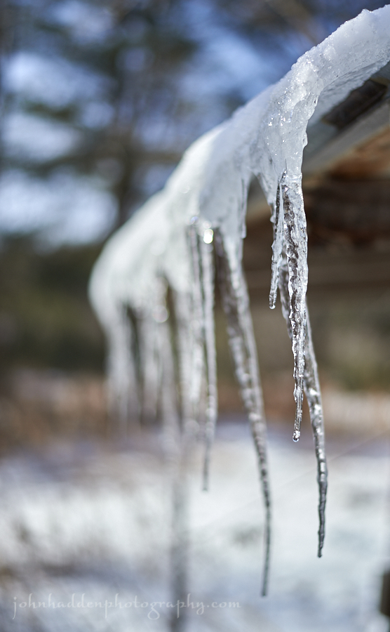
The sun is begining to get stronger as we move towards March. The roof of our chicken coop is south-facing allowing for some nice icicles to form on sunny days.
Nikon D600, Nikon 52mm prime lens, ISO 160, f/1.8, 1/4000″ exposure.
Tuesday, February 13, 2018


Fine power snow on bleaching beech leaves
Morning Observation:
This morning in Huntington at 7:50AM it’s currently 5 degrees under clear skies. Winds are calm. Relative humidity is 88%, dewpoint 2, barometric pressure 30.83” and rising slowly. We have 6” of hard snow at the stake. Yesterday’s high was 45 (at midnight), and the daytime high was 33. The overnight low was 4.
Forecast:
High pressure cresting over the Northeast this afternoon will deliver plentiful sunshine and seasonal to above normal temperatures through Wednesday. Temperatures Thursday will bump into the 40s along with the chance of some spotty rain showers. A cold front will bring more widespread precipitation Thursday night into Friday with rain showers likely south and a mix or snow north. We may eke out a couple of inches of snow locally if we’re lucky. The upcoming weekend is looking dry and seasonable.
We’ll see skies this morning with a few afternoon clouds. Highs will be around 25F with light and variable winds. Tonight should be partly cloudy with lows around 20F and SSW winds at 10 to 20 mph.
Wednesday should be partly cloudy and mild with highs around 42F and SSW winds at 10 to 20 mph. Wednesday night should be partly cloudy with lows around 36F and SSW winds at 10 to 15 mph.
Thursday’s looking cloudy with occasional showers for the afternoon. Highs will be around 44F with SSW winds at 10 to 15 mph. Chance of rain is 40%. Thursday night should be cloudy early followed by a mixture of light rain and snow overnight. Lows will be around 34F with SSW winds at 5 to 10 mph. Chance of precipitation is 70% with snow accumulations of less than one inch.
Almanac:
Last year on this date we had a high of 27 and a low of 18. We picked up 10.75″ of new snow and had 12″ at the stake.
Burlington averages for this date are highs of 30 and lows of 12.
The record high was 53°F in 1937.
The record low was -25°F in 1967.
Sky Notes:
Sunrise: 6:56AM
Sunset: 5:19PM
Length of Visible Light: 11h 22m
Length of Day: 10h 22m
Tomorrow will be 2 minutes 50 seconds longer
The Moon is a waning crescent, 27 days old with 6% illumination.
Moonrise: 5:36AM
Moonset: 3:18PM
About Today’s Photo:
Young beech trees will often hold their leaves clear through the winter into spring when new growth finally forces last year’s leaves to drop. I like watching the progression of color of the old leaves through the winter as they bleach out and fade to a ghostly white. These leaves are almost there.
Panasonic GX8, Lumix 14-140mm lens @ 102mm, ISO 400, f/5.4, 1/1000″ exposure.
Monday, February 12, 2018


A shelf fungus as a snow shelf
Morning Observation:
This morning in Huntington at 8:10AM it’s currently 26 degrees (and falling) under overcast skies. Winds are out of the west at 0-3 mph. Relative humidity is 79%, dewpoint 21, barometric pressure 30.28” and rising rapidly. We picked up 0.02” of rain in the past 24hrs and have 6” of snow at the stake. Yesterday’s high was 48 (at 11:00PM) and the temperature has been falling ever since, so no overnight low really…
Forecast:
We’ve got a quiet few days ahead of us weather-wise. A cold front moved through the region overnight bringing rapidly cooling temperatures to start the day off. High pressure will build in through the day today bringing clearing skies and seasonable conditions through much of the work week with warming temperatures by Wednesday and more mixed precipitation.
We’ll see partly cloudy skies today with highs around 29F and WNW winds at 10 to 20 mph. Tonight should be clear and chilly wth lows near 5F and NNW winds at 5 to 10 mph.
Tuesday should be mostly sunny with highs around 23F and light and variable winds. Tuesday night should be partly cloudy early with increasing clouds overnight. Lows will be around 18F with SSW winds at 10 to 15 mph.
Wednesday’s looking partly cloudy in the morning giving way to mostly sunny skies for the afternoon. Highs will be around 41F with SSW winds at 10 to 20 mph. Wednesday night should be partly cloudy with inncreasing clouds and periods of showers after midnight. Lows will be around 38F with south winds at 5 to 10 mph. Chance of rain is 50%.
Almanac:
Last year on this date we had a high of 28 and a low of 5. We had 7″ of snow at the stake.
Burlington averages for this date are highs of 30 and lows of 12.
The record high was 56°F in 1999 (we had a high of 61).
The record low was -30°F in 1979.
Sky Notes:
Sunrise: 6:57AM
Sunset: 5:17PM
Length of Visible Light: 11h 20m
Length of Day: 10h 20m
Tomorrow will be 2 minutes 49 seconds longer
The Moon is a waning crescent, 26 days old with 11% illumination.
Moonrise: 4:52AM
Moonset: 2:24PM
About Today’s Photo:
I came across this good sized shelf fungus on a maple while skiing up at Camel’s Hump Nordic. Looks like it was doing its job well of providing a shelf for the fresh snow.
Panasonic GX8, Lumix 14-140mm lens @ 37mm, ISO 400, f/7.1, 1/160″ exposure.
Sunday, February 11, 2018


Fine powder snow on hobblebush
Morning Observation:
This morning in Huntington at 8:15AM it’s currently 24 degrees under overcast skies. Winds are calm. Relative humidity is 93%, dewpoint 22, barometric pressure 30.14” and falling slowly. We picked up 0.6” of rain/melted precipitation and 1” of snow and have 8” at the stake. Yesterday’s high was 40, and the overnight low was 23.
Anyone else have fun on our dirt roads last evening around 7:00PM before the snow started falling?
Forecast:
High pressure across southern Quebec has pushed the surface frontal
boundary south of Vermont early this morning putting us on the cold side of thing albeit briefly. Developing low pressure across the Ohio Valley will track northeastward across the St. Lawrence Valley this evening allowing the boundary to lift northward as a warm front later today. This will bring periods of light mixed precipitation this afternoon, followed by a change to intermittent plain rain in most areas. A trailing cold front will bring a chance of rain or snow showers overnight. Drier and more seasonable weather are on tap for Monday and Tuesday. Another warm up is in the cards for Thursday…
We’ll ss cloudy skies with a few showers of rain this afternoon. Areas of freezing rain possible (like we saw last night..) Highs will be near 40F with SE winds at 10 to 15 mph. Chance of rain is 30%. Tonight should bring rain showers early tapering to cloudy skies overnight. Lows will be around 26F with SSW winds shifting to WNW at 10 to 20 mph. Chance of rain is 40%.
Monday should be partly cloudy with highs around 28F and WNW winds at 10 to 15 mph. Monday night should be partly cloudy with lows around 7F and NNW winds at 5 to 10 mph.
Tuesday’s looking mostly sunny with highs around 25F and light and variable winds. Tuesday night should be partly cloudy with lows near 20F and south wids at 5 to 10 mph.
Almanac:
Last year on this date we had a high of 24 and a low of 6. We picked up 1″ of new snow and had 7″ at the stake.
Burlington averages for this date are highs of 30 and lows of 12.
The record high was 58°F in 1981.
The record low was -27°F in 1979.
Sky Notes:
Sunrise: 6:58AM
Sunset: 5:16PM
Length of Visible Light: 11h 17m
Length of Day: 10h 17m
Tomorrow will be 2 minutes 48 seconds longer
The Moon is a waning crescent, 25.5 days old with 17% illumination.
Moonrise: 4:04AM
Moonset: 1:35PM
About Today’s Photo:
After the snowfall the other day and before the winds (and later rain) got to work, fine “Champlain” powder graced the branches of tree and understory shrubs like this hobblebush up in the high country above Camel’s Hump Nordic.
Panasonic GX8, Lumix 14-140mm lens @ 46mm, ISO 400, f8, 1/800″ exposure.
Saturday, February 10, 2018


Fisher tracks in a stream bed
Morning Observation:
This morning in Huntington at 8:10AM it’s currently a balmy 35 degrees and snowing lightly under overcast skies. Winds are out of the south at 3-6 mph. Relative humidity is 87%, dewpoint 32, barometric pressure 30.21’ and steady. We picked up 0.50” of new snow overnight and have 8.5” at the stake. Yesterday’s high was 25, and the overnight low was 25.
There is a Winter Weather Advisory in effect until 7:00AM Sunday.
Forecast:
A quasi-stationary frontal zone extending from central New York into southern Vermont will deliver cloudy skies with periods of snow across the region today. A wave of low pressure moving along the frontal boundary will bring warmer air aloft, with periods of sleet and freezing rain mixing in with the snow tonight into Sunday. The best chance for mixed precipitation will be across central and southern Vermont tonight. Snowfall amounts will range from 1″ to 3″ in the Champlain Valley and the valleys of south-central Vermont, to 3″ to 6″ across central and northeastern Vermont and the ‘Dacks. High pressure will bring drier air to the region Monday and Tuesday.
We’ll see scattered snow showers this morning giving way to a mixture of rain and snow for the afternoon. Highs will be around 36F with SW winds at 10 to 15 mph. Chance of precipitation is 100% with 1″ of snow expected. Tonight should bring snow this evening with some mixed winter precipitation possible south. Lows will be around 24F with light and variable wind. Chance of snow is 90% with snow accumulations of 1″ to 3″.
Sunday should bring a wintry mix in the morning transitioning to mainly rain showers in the afternoon. There’s not a whole lot of moisture in this system to work with, so snowpack impacts should be minimal. Highs will be around 37F with east winds at 5 to 10 mph. Chance of precipitation is 50%. Sunday night any rain showers should taper off to overcast skies late. Lows will be around 25F with SSW winds shifting to WNW at 10 to 15 mph. Chance of rain is 60%.
Monday’s looking partly cloudy with highs near 30F and NW winds at 10 to 15 mph. Monday night should be mostly clear and chilly with lows around 5F and light and variable winds.
Almanac:
Last year on this date we had a high of 12 and a low of -1. We had 6″ of snow at the stake.
Burlington averages for this date are highs of 29 and lows of 11.
The record high was 46°F in 1925.
The record low was -26°F in 1948.
Sky Notes:
Sunrise: 7:00AM
Sunset: 5:14PM
Length of Visible Light: 11h 14m
Length of Day: 10h 14m
Tomorrow will be 2 minutes 46 seconds longer
The Moon is a waning crescent, 24.6 days old with 25% illumination.
Moonrise: 3:12AM
Moonset: 12:50PM
About Today’s Photo:
I was out skiing with some friends at Camel’s Hump Nordic yesterday, and we came across this nice set of fisher tracks running along the stream bed under the bridge at the edge of the Windekind Farm meadow. The fisher left perfect 2×2 bounding prints as it moved downstream. Fishers will often use waterways to navigate their wide ranging territory.
Panasonic GM5, Lumix 12-32mm lens @ 12mm, ISO 800, f/16, 1/1300″ exposure.
Friday, February 9, 2018

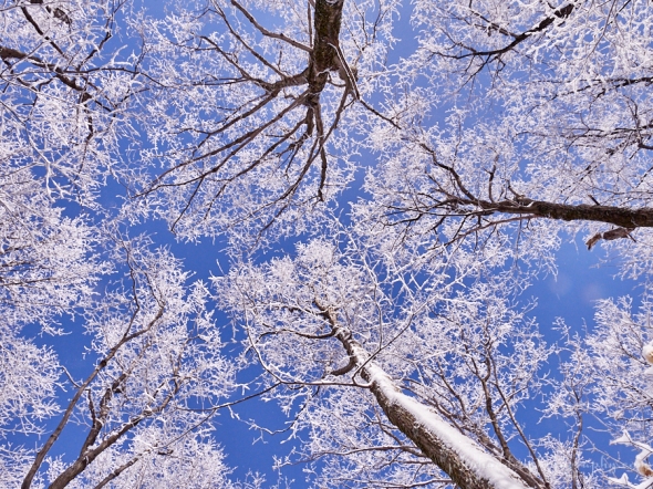
Snow-bedecked crowns of trees against the blue sky
Morning Observation:
This morning in Huntington at 8:05AM it’s currently 6 degrees under partly cloudy skies. Winds are calm. Relative humidity is 89%, dewpoint 4, barometric pressure 30.50” and rising slowly. We have 9” of snow at the stake. Yesterday’s high was 22, and the overnight low was 1.
Forecast:
Low pressure moving out of the Ohio River valley will lift a warm front into the region today and remain relatively stationary along the international border through Sunday. This will result in a fairly long duration precipitation event with light snow expected today and Saturday along with some wintry mix on Sunday. High pressure will build in Monday and Tuesday bringing colder and drier conditions. Chances of precipitation will return midweek through next weekend as numerous disturbances quickly move through the region.
We’ll see cloudy skies today with highs around 22F and SSW winds at 5 to 10 mph. Tonight should bring snow showers. Lows will be around 18F with south winds at 10 to 15 mph. Chance of snow is 60% with 1″ to 3″ inches of snow expected.
Saturday should bring periods of snow. Highs will be near 35F with SSW winds at 10 to 15 mph. Chance of snow is 90% with 1″ to 3″ inches of snow expected and perhaps some mixed precipitation in southern areas. Saturday night should be cloudy with snow showers and some mixed precipitation possible. Lows will be around 25F with light and variable winds. Chance of snow is 60% with snowfall around 1″.
Sunday should bring snow during the morning mixing with sleet or rain at times during the afternoon. Highs will be near 35F with light and variable winds. Chance of precipitation is 80% with snowfall around 1″. Sunday night should bring rain, sleet, and snow in the evening then remaining overcast late. Lows will be around 24F with WNW winds at 5 to 10 mph. Chance of snow is 80%.
Almanac:
Last year on this date we had a high of 23 and a low of -2. We picked up 0.05″ of rain and 2.25″ of snow and had 5.75″ at the stake.
Burlington averages for this date are highs of 29 and lows of 11.
The record high was 53°F in 1925.
The record low was -28°F in 1934.
Sky Notes:
Sunrise: 7:01AM
Sunset: 5:13PM
Length of Visible Light: 11h 12m
Length of Day: 10h 11m
Tomorrow will be 2 minutes 45 seconds longer
The Moon is a waning crescent, 23.7 days old with 34% illumination.
Moonrise: 2:16AM
Moonset: 12:10PM
About Today’s Photo:
The high country was lovely yesterday as the sun came out lighting up the snow bedecked trees. I was up in the Lion’s Ridge area of the Camel’s Hump Nordic Ski Center yesterday where the powder was plentiful and the forest was magical.
Panasonic GX8, Lumix 14-140mm lens @ 14mm, ISO 400, f/14, 1/250″ exposure.
Thursday, February 8, 2018


Corn stubble above thin snow near the Huntington River
Morning Observation:
This morning in Huntington at 7:40AM it’s currently 14 degrees and snowing lightly under overcast skies. Winds are calm. Relative humidity is 86%, dewpoint 10, barometric pressure 30.28” and rising rapidly. We picked up 4.75” of new snow (not as much as hoped for!) and have 10” at the stake. Yesterday’s high was 24, and the overnight low was 14.
Forecast:
Fairly quiet weather is on tap for today with some light snow showers possible in higher terrain. A weak warm front will move through Friday afternoon and evening, bringing more widespread light snow that will taper off Saturday afternoon. We may see a couple of inches out of that. By Saturday night however, another warm front will bring more precipitation, with a rain and snow mix possible—rain being most likely in southern and eastern Vermont while we remain in a cooler sector with mostly snow. Fingers crossed. The pattern will remain active for the next week as well with continued fast moving systems bringing quick bouts of precipitation to the region. Temperatures should remain seasonal, however, some of the precipitation may lean in the wet direction. Stay tuned.
We’ll see mostly cloudy skiew today with a few flurries possible. Highs will be around 21F with WNW winds at 5 to 10 mph. Tonight should be cloudy early followed by partial clearing. Lows will be around 8F with SW winds at 5 to 10 mph.
Friday should be overcast wit a few flurries or snow showers possible. Highs will be around 23F with SSW winds at 5 to 10 mph. Friday night should be cloudy with snow. Lows will be near 20F with south winds at 5 to 10 mph. Chance of snow is 70% with snow accumulations of 1″ to 3″.
Saturday should bring more snow showers. Highs will be around around 35F with WSW winds at 5 to 10 mph. Chance of snow is 60% with snowfall around 1″. Saturday night should be cloudy with snow showers with some mixed precipitation possible south and east. Lows will be around 27F with light and variable winds. Chance of snow is 70% with snowfall around 1″.
Almanac:
Last year on this date we had a high of 45 and a low of 23. We picked up 0.16″ of rain and 1.25″ of snow and had 6″ at the stake.
Burlington averages for this date are highs of 29 and lows of 11.
The record high was 51°F in 1925.
The record low was -25°F in 1934.
Sky Notes:
Sunrise: 7:02AM
Sunset: 5:12PM
Length of Visible Light: 11h 9m
Length of Day: 10h 9m
Tomorrow will be 2 minutes 44 seconds longer
The Moon is a waning crescent, 22.8 days old with 43% illumination.
Moonrise: 1:17AM
Moonset: 11:35AM
About Today’s Photo:
Corn stubble marches off into the distance in this view looking east from the Main Road across the old Brace Farm field.
Panasonic GX8, Lumix 14-140mm lens @ 14mm, ISO 200, f/14, 1/320″ exposure.
Wednesday, February 7, 2018

An ermine slide track at Sleepy Hollow
Morning Observation:
This morning in Huntington at 7:55AM it’s currently 15 degrees under overcast skies. Winds are calm. Relative humidity is 90%, dewpoint 13, barometric pressure 30.44” and falling rapidly. We picked up 0.25” of new snow in the past 24hrs and have 6” at the stake. Yesterday’s high was 27, and the overnight low was 4.
There is a Winter Storm Warning in effect for our region from 8:00AM this morning to 1:00AM Thursday.
Forecast:
Widespread accumulating snow will spread across the region today through tonight as a low pressure system moves from the Ohio River Valley to the New England Coast. The snow will be light in the morning, then become heavy at times during the afternoon into early evening hours. The snow will quickly end this evening into the early overnight hours. Weak high pressure will build in Thursday, followed by some light snow Friday into Friday night. After a brief break
Saturday, expect another round of precipitation—hopefully snow for us—Saturday night into early Sunday morning.
Snow should begin to move into the region by mid morning. Highs will be around 24F with SE winds at 5 to 10 mph. Chance of snow is 100% with 5″ to 8″ of snow expected. Snow showers will become more widely scattered overnight. Lows will be around 12F with NW winds at 10 to 15 mph. Chance of snow is 80% with additional snowfall around 1″. Snowfall totals for the event should be in the range of 6″-8″ locally with up to 12″ over the south central and central Greens.
Thursday should be mostly cloudy with a few flurries possible. Highs will be around around 20F with WNW winds at 5 to 10 mph. Thursday night should be partly cloudy with lows around 8F and SW winds at 5 to 10 mph.
Friday’s looking overcast with a few flurries or snow showers possible. Highs will be around 22F with SSW winds at 5 to 10 mph. Friday night should bring snow showers early, with a steadier snow developing late at night. Lows will be around 18F with SSE winds at 5 to 10 mph. Chance of snow is 70% with snow accumulations of 1″ to 3″.
Almanac:
Last year on this date we had a high of 36 and a low of 18. We picked up 1.5″ of new snow and had 6.25″ of snow at the stake.
Burlington averages for this date are highs of 29 and lows of 11.
The record high was 49°F in 2005 (we had a high of 45).
The record low was -27°F in 1993.
Sky Notes:
Sunrise: 7:04AM
Sunset: 5:10PM
Length of Visible Light: 11h 7m
Length of Day: 10h 6m
Tomorrow will be 2 minutes 42 seconds longer
The Moon is in its last quarter, 21.8 days old with 53% illumination.
Moonrise: 12:16AM
Moonset: 11:03AM
About Today’s Photo:
Molly at Sleepy Hollow alerted me to this ermine track along the trail. In deeper snow (about 3″-4″ in this case) ermine will bound through the snow leaving a trench in their wake. If you look closely at the top of the track here, you just might make out the deeper impressions of the feet. As the ermine got to the steeper drop, it slid down the snow leaving a smooth trench (we were wondering if it had a smile on its face…) This particular ermine was quite active sometime Monday as its tracks showed it wondering extensively around the area.
Panasonic GM5, Lumix 12-32mm lens @ 12mm, ISO 800, f/16, 1/500″ exposure.
Tuesday, February 6, 2018

A red oak leaf in the snow
Morning Observation:
This morning in Huntington at 7:35AM it’s currently 17 degrees and snowing lightly under overcast skies. Winds are calm. Relative humidity is 81%, dewpoint 12, barometric pressure 30.27” and rising slowly. We’ve picked up just a trace of new snow and have 6” at the stake. Yesterday’s high was 34, and the overnight low was 1.
There is a Winter Storm Warning in effect from 8:00AM Wednesday to 1:00AM Thursday.
Forecast:
Light snow will continue to spread over the region this morning as a clipper low passes over the area. Snow showers will taper off this afternoon/evening and a brief ridge of high pressure will build in overnight. Wednesday, a low pressure system will cross the central Appalachians and move to the southern New England Coast, bringing widespread snow to the region. Snow will be heavy at times between noon and 7:00PM Wednesday, making travel conditions messy during the
evening commute on Wednesday. The snow will wind down Wednesday night, but we’ll see a bit more snow Friday and perhaps some limited mixed precipitation on Sunday.
We’ll see cloudy skies today with a few flurries or snow showers possible. Highs will be around 27F with SW winds at 10 to 15 mph. Tonight should be partly cloudy early followed by cloudy skies overnight. Lows will be near 10F with light and variable winds.
Wednesday should be cloudy with snow developing by noon. Highs will be around 23F with ESE winds at 5 to 10 mph. Chance of snow is 100% with 5″ to 8″ of snow expected. Wednesday night snow in the evening will give way to lingering snow showers overnight. Lows will be around 12F with NNW winds at 5 to 10 mph. Chance of snow is 90% with snow accumulations of 1″ to 3″.
Thursday’s looking partly cloudy in the morning giving way to cloudy skies during the afternoon. Highs will be near 20F with WNW winds at 5 to 10 mph. Thursday night should partly cloudy with lows near 10F and SSW winds at 5 to 10 mph.
Almanac:
Last year on this date we had a high of 26 and a low of 12. We picked up 0.80″ of new snow and had 5.5″ at the stake.
Burlington averages for this date are highs of 29 and lows of 11.
The record high was 50°F in 2005 (we had a high of 55).
The record low was -24°F in 1993.
Sky Notes:
Sunrise: 7:05AM
Sunset: 5:09PM
Length of Visible Light: 11h 4m
Length of Day: 10h 3m
Tomorrow will be 2 minutes 41 seconds longer
The Moon is waning gibbous, 21 days old with 63% illumination.
No Moonrise
Moonset: 10:32AM
About Today’s Photo:
The red oak tree at the edge of our front yard holds most of its leaves through the winter. Winds will occasionally pull a few down and they’ll skitter across the snow leaving hopping tracks before coming to rest. They make for interesting little sculptures.
Panasonic GX8, Olympus 60mm macro lens, ISO 640, f/2.8, 1/8000″ exposure.
Monday, February 5, 2018

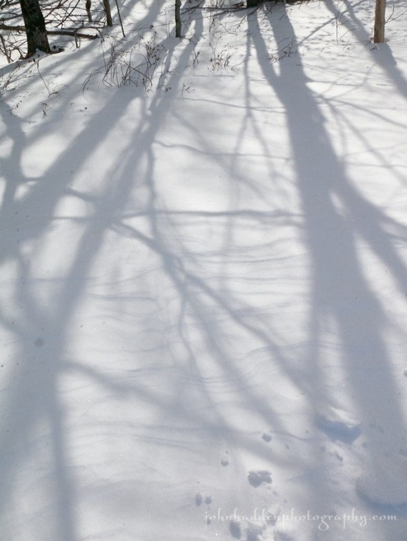
Shadows play across lightly drifted snow
Morning Observation:
This morning in Huntington at 8:00AM it’s currently 25 degrees and falling under cloudy skies. Winds are out of the west at 0-4 mph. Relative humidity is 88%, dewpoint 21, barometric pressure 29.78” and rising rapidly. We picked up a layered 3” of snow (2” of wet snow, a thin layer of crust, and another inch of fluffier snow on top) and have 6” at the stake. Yesterday’s high was 37, and the overnight low was 32 dropping like a stone at 6:30AM to 25 now.
Forecast:
We’ve got an active (and snowy!) weather picture ahead for the upcoming week. Morning snow showers over will taper off through by midday as a cold front slides through (hence this morning’s dropping temperatures. After a mostly sunny but chilly day today, a clipper low approaching from the Great Lakes will bring a return of snow showers later tonight and into tomorrow. Not a whole lot of snow from this one. We’ll see a brief break in snow Tuesday night before low pressure tracking northeastward from the Ohio River Valley brings widespread
plowable snow Wednesday and Wednesday night. We’re looking at 5″-10″ locally with higher amounts—up to a foot—in the southern and central Greens. After this system moves through, we’ll see another chance for snow towards the end of the week. Get your snow shovels ready!
Snow showers will be wrapping up this morning and skies will become sunny later today. Morning highs of 27F will fall to near 15 with WNW winds at 10 to 20 mph. Chance of snow is 80%. Tonight should be partly cloudy skies early giving way to cloudy skies late with a few flurries or snow showers possible. Lows will be around 9F with SSW winds at 5 to 10 mph.
Tuesday should be cloudy with a few flurries or snow showers possible. Highs will be around 28F with SW winds at 10 to 15 mph. Tuesday night should be partly cloudy in the evening becoming cloudy overnight. Lows will be around 9F with NNW winds at 5 to 10 mph.
Wednesday’s looking cloudy with snow. Highs will be around 24F with ESE winds at 5 to 10 mph. Chance of snow is 100% with 5″ to 8″ of snow expected. Wednesday night snow in the evening will give way to lingering snow showers overnight. Lows will be around 12F with NNW winds at 5 to 10 mph. Chance of snow is 90% with 1″ to 3″ of snow expected.
Almanac:
Last year on this date we had a high of 32 and low of 23. We had 5″ of snow at the stake.
Burlington averages for this date are highs of 28 and lows of 11.
The record high was 51°F in 1991.
The record low was -27°F in 1908.
Sky Notes:
Sunrise: 7:06AM
Sunset: 5:07PM
Length of Visible Light: 11h 2m
Length of Day: 10h 0m
Tomorrow will be 2 minutes 39 seconds longer
The Moon is waning gibbous, 20 days old with 72% illumination.
Moonrise: 11:14PM
Moonset: 10:04AM
About Today’s Photo:
These shadows caught my eye while skiing across the Windekind Farm meadow the other day.
Panasonic GM5, Lumix 12-32mm lens @ 18mm, ISO 400, f/16, 1/800″ exposure.
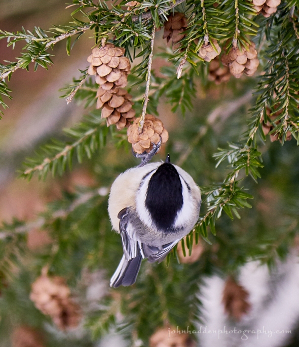
Sunday, February 4, 2018

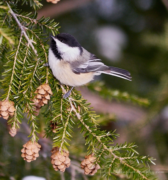
A chickadee feeding from hemlock cones
Morning Observation:
This morning in Huntington at 8:05AM it’s currently 30 degrees under overcast skies. Winds are out of the south at 3-6 mph. Relative humidity is 65%, dewpoint 20, barometric pressure 30.06” and steady. We have 3.5” of snow at the stake. Yesterday’s high was 23, and the overnight low was 23.
There is a Winter Weather Advisory in effect from 7:00AM this morning to
7:00AM Monday.
Forecast:
Snow showers will kick up during the day today as low pressure tracks north and west of the St. Lawrence Valley and a secondary low develops south of New England. A period of steady light to moderate snow is expected this afternoon into this evening. We could see 4″-6″ by Monday in the ‘Dacks, northern Greens and east of the spine of the Greens. The Champlain Valley and points south ad east should only see 1″-3″ with a bit of rain mixed in as warm air advection pops temperatures into the mid 30s. Another quick moving low pressure system is expected Tuesday night into Wednesday bringing the chance for additional snow.
We’ll see cloudy skies with snow showers this morning and steady snow likely this afternoon. Temperatures will be nearly steady in the low to mid 30s with south winds at 15 to 25 mph. Chance of snow is 90% with snow accumulations of 1″ to 3″. Tonight should bring periods of snow with some rain or sleet mixed in in valley locations. Temperatures will drop overnight as a cold front swings through with lows around 17F and SW winds at 5 to 10 mph. Chance of snow is 100% with snow accumulations of 1″ to 3″.
Monday should be partly cloudy with morning highs of 23F falling to near 15 midday and WNW winds at 10 to 20 mph. Monday night should be partly cloudy early followed by mostly cloudy skies and a few snow showers later at night. Lows will be around 8F with SW winds at 5 to 10 mph. Chance of snow is 40%.
Tuesday’s looking cloudy with highs around 27F and SSW winds at 10 to 15 mph. Tuesday night should be cloudy with lows around 12F and light and variable winds.
Almanac:
Last year on this date we had a high of 27 and a low of 7. We picked up 1.75″ of new snow and had 5.5″ at the stake.
Burlington averages for this date are highs of 28 and lows of 11.
The record high was 54°F in 2016 (we had a high of 57).
The record low was -26°F in 1963.
Sky Notes:
Sunrise: 7:08AM
Sunset: 5:06PM
Length of Visible Light: 10h 59m
Length of Day: 9h 58m
Tomorrow will be 2 minutes 37 seconds longer
The Moon is waning gibbous, 19 days old with 81% illumination.
Moonrise: 10:08PM
Moonset: 9:35AM
About Today’s Photo:
I was watching this chickadee as it hopped from branch to branch in the hemlock by my studio stairs. It would dangle upside down and pluck seeds from within the hemlock cones, then perch to munch on its quarry. It was hard to get a good shot of the action, but I’ve included one below. I like the one-footed hold on the cone.
Panasonic GX8, Lumix 100-300mm lens @ 300mm, ISO 1000, f/5.6, 1/500″ exposure.