Monday, April 30, 2018


A pair of eastern newts feed on wood frog eggs in our pond
Morning Observation:
This morning in Huntington at 7:45AM it’s currently 36 degrees under overcast skies. Winds are calm. Relative humidity is 98%, dewpoint 35, barometric pressure 29.90” and rising slowly. We picked up 0.88” of rain/melted precipitation and about 0.50” of wet snow in the past 24hrs. Yesterday’s high was 47, and the overnight low was 33.
Forecast:
The slow moving upper level low that’s treating us to cool and wet weather will finally begin to move eastward through the day today and be centered over the Gulf of Maine by this evening. High pressure will bring fair and dry conditions to the region Tuesday and Wednesday with temperatures hitting the mid to upper 70s by Wednesday afternoon. More unsettled weather will return Wednesday night through the end of the work week as another moisture laden low moves into the region.
We’ll see cloudy skies with periods of rain this afternoon and a few rumbles of thunder possible. Highs will be around 48F with NNW winds at 5 to 10 mph. Chance of rain is 70%. Tonight rain showers early will become a more steady rain overnight. Lows will be around 42F with light and variable winds. Chance of rain is 70%.
Tuesday should be cloudy early, then become partly cloudy in the afternoon. A stray shower or thunderstorm is possible. Highs will be around 67F with WSW winds at 5 to 10 mph. Tuesday night should be partly cloudy with a slight chance of a rain shower. Lows will be near 55F with SSW winds at 5 to 10 mph.
Wednesday should be partly cloudy early with scattered thunderstorms developing in the afternoon as a cold front swings through. Highs will be around 79F with SW winds at 10 to 20 mph. Chance of rain is 40%. Wednesday night should bring scattered thunderstorms during the evening followed by occasional showers overnight. Lows will be near 60F with SW winds at 5 to 10 mph. Chance of rain is 60%.
Almanac:
Last year on this date we had a high of 51 and a low of 30.
Burlington averages for this date are a high of 62 and a low of 40.
The record high was 84°F in 2004 (we had a high of 82).
The record low was 27°F in 1967.
Sky Notes:
Sunrise: 5:45AM
Sunset: 7:55PM
Length of Visible Light: 15h 13m
Length of Day: 14h 9m
Tomorrow will be 2 minutes 40 seconds longer
The Moon is waning gibbous, 15 days old with 99% illumination.
Moonrise: 8:36PM
Moonset: 6:27AM
About Today’s Photo:
Our pond is a hive of activity right now. Wood frogs and peepers are busy mating and laying eggs, and our bountiful crop of eastern newts are enjoying fresh eggs for breakfast, lunch, and dinner. These newts are in their adult stage. Their bright orange juvenile forms—red efts—live in the woods before returning to the water to breed.
Panasonic GX8, Lumix 14-140mm lens @ 84mm, ISO 1600, f/8, 1/125″ exposure.
Sunday, April 29, 2018

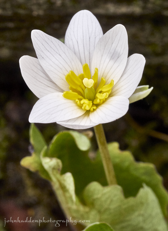
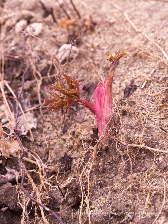
Blood root blossoming by Fargo Brook
Morning Observation:
This morning in Huntington at 7:50AM it’s currently 43 degrees and raining lightly under overcast skies. Winds are out of the south at 0-4 mph. Relative humidity is 97%, dewpoint 42, barometric pressure 29.84” and rising slowly. We picked up 0.13” of rain in the past 24hrs. Yesterday’s high was 64, and the overnight low was 43.
Forecast:
A slow moving, nearly stationary, upper level low currenlty parked over the region will deliver unsettled weather across the North Country into Tuesday. Occasional rain showers are expected through Monday with some snow mixing in at elevations above 2000′. High pressure will bring fair and dry conditions later Tuesday and Wednesday, with temperatures bumping into the 70s Wednesday. More unsettled weather is in the cards for later in the week, but temperatures should remain in the normal range.
We’ll see periods of rain today with high only around 45F and NW winds at 5 to 10 mph. Chance of rain is 100% with rainfall near 0.50″. Tonight rain is likely with snow mixing in above 2000′. Lows will be around 37F with WSW winds at 5 to 10 mph. Chance of rain is 100% with rainfall near 0.50″.
Monday rain showers in the morning should become a steady light rain in the afternoon with rumbles of thunder possible. Highs will be around 50F with NNW winds at 5 to 10 mph. Chance of rain is 70%. Monday night should be cloudy with a slight chance of a shower in the evening. Lows will be near 40F with light and variable winds.
Tuesday’s looking partly cloudy with highs near 63F and WSW winds at 5 to 10 mph. Tuesday night should be cloudy early with partial clearing expected late. Lows will be around 53F with SSW winds at 5 to 10 mph.
Almanac:
Last year on this date we had a high of 71 and a low of 43.
Burlington averages for this date are a high of 61 and lows of 40.
The record high was 85°F in 1986.
The record low was 24°F in 1934.
Sky Notes:
Sunrise: 5:46AM
Sunset: 7:53PM
Length of Visible Light: 15h 10m
Length of Day: 14h 7m
Tomorrow will be 2 minutes 41 seconds longer
The Moon is the full “Pink” moon (Northeast Native American), 14 days old with 100% illumination.
Moonrise: 7:32PM
Moonset: 5:57AM
About Today’s Photo:
One of my favorite spring ephemerals, blood root, is now blooming along Fargo Brook. This early blooming and hardy flower uses its leathery leaves to protect its blossom when the weather turns chilly, wrapping it up in a cozy shroud, and letting it open up in warmer weather like we had yesterday. I imagine it’s wrapped up tight this morning!
Panasonic GX8, Olympus 60mm macro lens, ISO 1600, f/14, 1/160″ exposure.
Saturday, April 28, 2018

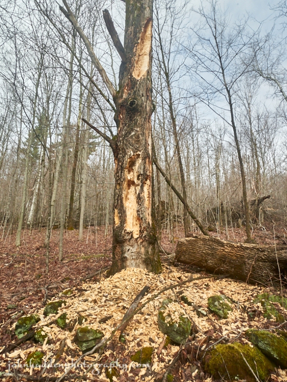
A well worked tree…
Morning Observation:
This morning in Huntington at 7:35AM it’s currently 48 degrees under mostly cloudy skies. Winds are out of the south at 1-4 mph. Relative humidity is 98%, dewpoint 47, barometric pressure 29.72” and rising slowly. We picked up 0.15” of rain in the past 24hrs. Yesterday’s high was 56, and the overnight low was 38.
Forecast:
A slow moving upper level trough of low pressure over the Great Lakes
region this morning will continue to track toward the North Country bringing rain showers through the weekend. A cold front will accompany the trough settling much cooler air across the region Sunday into Monday before it finally begins to exit the region. Temperatures will moderate significantly heading towards the middle of next week.
We’ll see cloudy skies with periods of rain this afternoon and a rumble of thunder possible. Highs will be around 63F with SSW winds at 5 to 10 mph. Chance of rain is 60%. Tonight will bring rain early with cloudy skies and showers overnight. Lows will be around 42F with light and variable winds. Chance of rain is 80% with rainfall around a 0.25″.
Sunday should bring occasional rain. Highs will only be around 46F with NW winds at 5 to 10 mph. Chance of rain is 80% with rainfall near 0.25″. Sunday night should be cloudy with periods of rain and some possible snow mixed in over mid to upper elevations. Lows will be around 37F with WSW winds at 5 to 10 mph. Chance of rain is 80% with rainfall around 0.25″.
Monday should bring rain showers early with overcast skies later in the day. Highs will be around 50F with WNW winds at 5 to 10 mph. Chance of rain is 60%. Monday night should be cloudy with occasional rain showers. Lows will be around 38F with light and variable winds. Chance of rain is 40%.
Almanac:
Last year on this date we had a high of 80 and a low of 55. We picked up 0.03″ of rain.
Burlington averages for this date are a high of 61 and lows of 40.
The record high was 90°F in 1990.
The record low was 24°F in 1947.
Sky Notes:
Sunrise: 5:48AM
Sunset: 7:52PM
Length of Visible Light: 15h 7m
Length of Day: 14h 4m
Tomorrow will be 2 minutes 42 seconds longer
The Moon is waxing gibbous, 13 days old with 96% illumination.
Moonrise: 6:26PM
Moonset: 5:29AM
About Today’s Photo:
I came across this well worked tree while running yesterday. It bares he unmistakable handiwork of a pileated woodpecker, who had excavated the large holes in search of hidden bugs. I’d run by this tree the week before (in the crusty snow…) and it hadn’t been touched then, so the pileated responsible really went to town during the intervening days.
Panasonic GM5, Lumix 12-32mm lens @ 12mm, ISO 400, f/13, 1/160″ exposure.
Friday, April 27, 2018

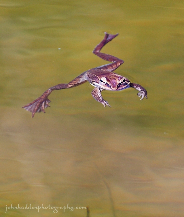
A wood frog floats in the pond
Morning Observation:
This morning in Huntington at 6:50AM it’s currently 38 degrees under partly cloudy skies. Winds are calm. Relative humidity is 98%, dewpoint 38, barometric pressure 29.85” and rising slowly. We picked up 0.77” of rain in the past 24hrs. Yesterday’s high was 53, and the overnight low was 38.
Forecast:
This morning’s sunshine will give way to clouds and showers this afternoon as a trough of low pressure moving up along the Atlantic coast moves into our region later today. Precipitation will taper off later tonight, but another trough of low pressure approaching from the Great Lakes will slowly work its way into the North Country later Saturday and linger over the region Sunday into Monday bringing fairly widespread precipitation Saturday afternoon through Sunday. Temperatures will be on the cool side of normal Sunday. Showers will linger into Monday with continued below normal temperatures before a warming trend develops by the middle of next week.
We’ll see clouds moving in this morning with periods of rain this afternoon. Highs will be around 59F with south winds at 5 to 10 mph. Chance of rain is 90%. Tonight should be cloudy with periods of rain early. Lows will be around 45F with light and variable winds. Chance of rain is 90%.
Saturday should be mostly cloudy early, then become partly cloudy in the afternoon with a slight chance of rain showers. Highs will be around 64F with SSW winds at 5 to 10 mph. Saturday night should bring steady rain in the evening with showers continuing late. Lows will be around 43F with light and variable winds. Chance of rain is 70%.
Sunday should bring a steady rain in the morning with showers continuing in the afternoon. Highs will be around 46F with NW winds at 5 to 10 mph. Chance of rain is 90% with rainfall near a quarter of an inch. Sunday night should bring rain showers early with perhaps a snowflake or two over high elevations late. Lows will be around 37F with light and variable winds. Chance of precipitation is 50%.
Almanac:
Last year on this date we had a high of 75 and a low of 47. We picked up 0.04″ of rain.
Burlington averages for this date are a high of 60 and lows of 39.
The record high was 90°F in 1990).
The record low was 22°F in 1972.
Sky Notes:
Sunrise: 5:49AM
Sunset: 7:51PM
Length of Visible Light: 15h 4m
Length of Day: 14h 1m
Tomorrow will be 2 minutes 44 seconds longer
The Moon is waxing gibbous, 12 days old with 91% illumination.
Moonrise: 5:20PM
Moonset: 5:00AM
About Today’s Photo:
The wood frogs and peepers are doing their thing in the pond right now, creating quite the cacophony at night. While I have yet to be able to get a picture of a peeper (they are small!), the wood frogs are a bit more obliging.
Thursday, April 26, 2018

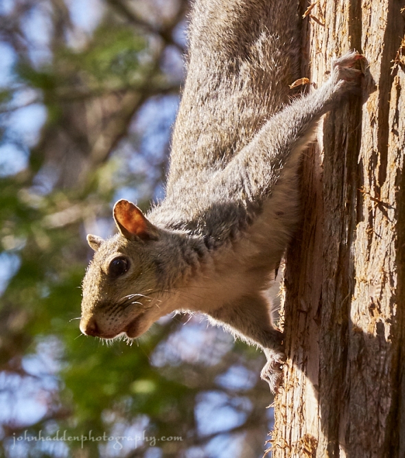
A grey squirrel considers the camera…
Morning Observation:
This morning in Huntington at 7:45AM it’s currently 48 degrees and raining steadily under overcast skies. Winds are calm. Relative humidity is 98%, dewpoint 48, barometric pressure 29.56”. We picked up 0.58” of rain in the past 24hrs. Yesterday’s high was 58, and the overnight low was 46.
Signs of Spring: We’ve got peepers and wood frogs going full bore in the pond!
Forecast:
An upper level low pressure system will move slowly east across
the region today brining more showers especially over northern New York and the northern half of Vermont. The low will move east of the region tonight allowing for a ridge of high pressure to move in along with dry weather. This will be short lived, however, as another low moves into the region from the southwest on Friday bringing showers back into the region. Unsettled weather and cooler temperatures are expected for the weekend.
We’ll see periods of rain roday with highs around 53F and west winds at 10 to 15 mph. Chance of rain is 100%. Tonight should be cloudy early with some clearing expected late. Lows will be around 42F with SW winds at 5 to 10 mph
Friday should be cloudy with periods of rain developing later in the day. Highs will be around 61F with south winds at 5 to 10 mph. Chance of rain is 80%. Friday night should be cloudy with occasional rain, mainly in the evening. Lows will be around 46F with light and variable winds. Chance of rain is 90%.
Saturday’s looking mostly cloudy early with showers developing later in the day. Highs will be around 64F with SW winds at 5 to 10 mph. Chance of rain is 40%. Saturday night should be cloudy with showers. Lows will be around 41F with light and variable winds. Chance of rain is 70%.
Almanac:
Last year on this date we had a high of 68 and a low of 48. We picked up 0.15″ of rain.
Burlington averages for this date are a high of 60 and lows of 39.
The record high was 84°F in 1913.
The record low was 20°F in 1919.
Sky Notes:
Sunrise: 5:51AM
Sunset: 7:50PM
Length of Visible Light: 15h 1m
Length of Day: 13h 58m
Tomorrow will be 2 minutes 45 seconds longer
The Moon is waxing gibbou, 11 days old with 84% illumination.
Moonrise: 4:11PM
Moonset: 4:30AM
About Today’s Photo:
We were down in New Jersey over the weekend visiting family. They had a feeder on their back patio that attracted all sorts of birds and a cadre of grey squirrels. This “Jersey squirrel” was patient enough for me to get a good shot of it. We rarely, if ever, see grey squirrels in our neck of the woods—we’re mostly red squirrel territory—so it was interesting watching them feed and interact. They seem a bit more social than red squirrels and able to tolerate others of their species better than their more diminutive cousins.
Panasonic GX8, Lumix 100-300mm lens @ 140mm, ISO 1600, f/10, 1/400″ exposure.
Saturday, April 21, 2018

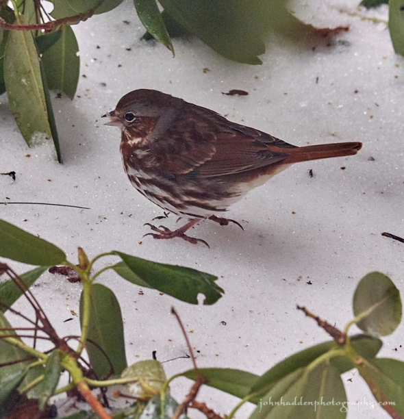
A fox sparrow stops by on its way north
Morning Observation:
This morning in Huntington at 7:40AM it’s currently 32 degrees under clear skies (!!!) Winds are calm. Relative humidity is 92%, dewpoint 30, barometric pressure 30.33” and steady. We still have 2” of snow at the stake. Yesterday’s high was 37, and the overnight low was 26.
Forecast:
It seems we might have turned the corner folks… High pressure and dry air are currently building into the region and and will deliver quiet weather into the middle of next week. Temperatures will remain below normal over the weekend but a warming trend will lead to near to slightly above normal
temperatures by mid week. We can expect plentiful sunshine through the middle of the workweek as well before rain returns to the region Wednesday.
We’ll see mostly sunny skies this morning giving way to some clouds this afternoon. Highs will be around 48F with NW winds at 10 to 15 mph. Tonight should be partly cloudy with lows near 30F and WNW winds at 5 to 10 mph.
Sunday should be mostly sunny with highs around 51F and NNW winds at 5 to 10 mph. Sunday night should be clear with lows around 34F and light and variable winds.
Monday’s looking sunny with highs around 61F and light and variable winds. Monday night should be partly cloudy with low around 43F and south winds at 5 to 10 mph.
Almanac:
Last year on this date we had a high of 50 and a low of 44. We picked up 0.35″ of rain.
Burlington averages for this date are a high of 58 and lows of 37.
The record high was 83°F in 1977.
The record low was 18°F in 1908.
Sky Notes:
Sunrise: 5:59AM
Sunset: 7:44PM
Length of Visible Light: 14h 46m
Length of Day: 13h 44m
Tomorrow will be 2 minutes 50 seconds longer
The Moon is a waxing crescent, 5.6 days old with 32% illumination.
Moonrise: 10:30AM
Moonset: 12:56AM
About Today’s Photo:
We were lucky again this year to have a red fox sparrow stop by on its way north. These large sparrows overwinter in central and eastern North America and breed in the taiga of Canada and Alaska. This fellow came through at about the same time that the white throated sparrows returned.
Panasonic GX8, Lumix 100-300mm lens @ 171mm, ISO 1600, f7.1, 1/400″ exposure.
Friday, April 20, 2018


“Um, where is this ‘spring’ you speak of…?”
Morning Observation:
This morning in Huntington at 8:00AM it’s currently 30 degrees and snowing lightly under overcast skies. Winds are out of the south at 0-3 mph. Relative humidity is 94%, dewpoint 29, barometric pressure 30.06” and rising rapidly. We picked up 0.02” of rain and 2.5” of snow and have 2.5” at the stake. Yesterday’s high was 40, and the overnight low was 30.
Forecast:
Mountain snow showers and valley rains will continue through the day today as an upper level trough slowly drifts east over the Canadian Maritimes. Lingering high elevation snow showers will lead to the potential for 3″ to 6″ of total snow accumulation at elevations above 1500′. Temperatures will remain below normal through the weekend as a warming trend begins on Sunday. Coming out of the weekend we should see near normal to slightly above nnormal temperatures along with dry conditions and plentiful sunshine. Really snow, this is the last time, right?
We’ll see snow this morning changing over to rain showers this afternoon. Highs will be near 40F with NW winds at 10 to 15 mph. Chance of rain is 90%. Tonight should be mostly cloudy with a few flurries or snow showers possible. Lows will be around 31F with NW winds at 5 to 10 mph.
Saturday should start out cloudy early, then become partly cloudy in the afternoon. Highs will be around 47F with NW winds at 10 to 15 mph. Saturday night should be partly cloudy with lows near 30F and NW winds at 5 to 10 mph.
Sunday’s looking mostly sunny with highs around 51F and NNW winds at 5 to 10 mph. Sunday night should be mostly clear with lows around 34F and light and variable winds.
Almanac:
Last year on this date we had a high of 50 and a low o 42. We picked up 0.62″ of rain.
Burlington averages for this date are a high of 57 and a low of 37.
The record high was 86°F in 1941.
The record low was 16°F in 1897.
Sky Notes:
Sunrise: 6:00AM
Sunset: 7:42PM
Length of Visible Light: 14h 43m
Length of Day: 13h 41m
Tomorrow will be 2 minutes 51 seconds longer
The Moon is a waxing crescent, 4.6 days old with 22% illumination.
Moonrise: 9:33AM
No Moonset
About Today’s Photo:
We had a good sized flock of robins come through yesterday evening as the snow began falling in earnest. They, like us, were no doubt wondering where spring is…
Panasonic GX8, Lumix 100-300mm lens @ 177mm, ISO 1600, f/5, 1/50″ exposure.
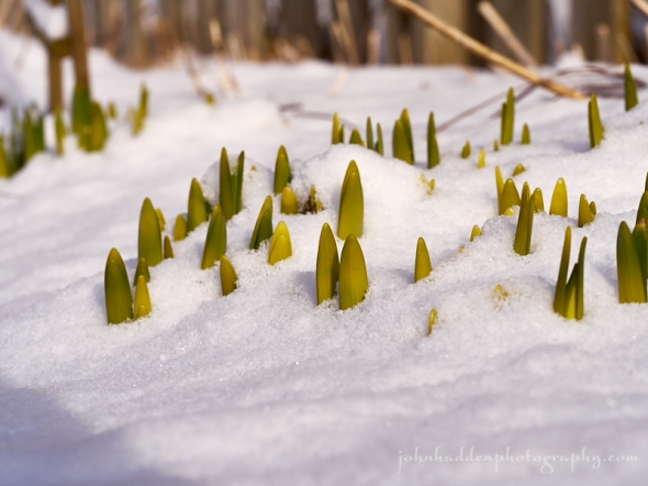
Thursday, April 19, 2018

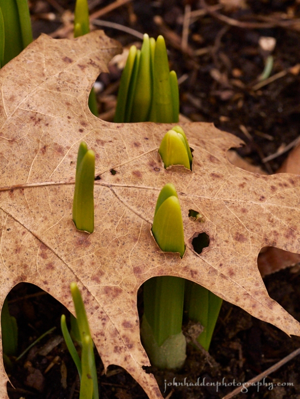
Daffodil shoots pierce an oak leaf in our garden
Morning Observation:
This morning in Huntington at 7:00AM it’s currently 35 degrees under mostly cloudy skies. Winds are calm. Relative humidity is 89%, dewpoint 32, barometric pressure 29.69” and steady. We picked up a 0.01” trace of rain yesterday and are back to bare ground at the snow stake. Yesterday’s high was 44, and the overnight low was 34.
Forecast:
Low pressure will track just south of the region today bringing widespread light rain and mountain snow today into Friday morning. Higher elevation
locations over 2000′ may see the potential for 3″ to 6″ of snow with a dusting to 1″ possible on valley floors by morning. Temperatures will remain below normal through the rest of the week before a warming trend begins over the weekend. Coming out of the weekend we should see near normal to slightly above normal temperatures along with dry conditions and plentiful sunshine. No promises (it is April after all…) but it’s looking like this may be the last snow of the season…
We’ll see rain and snow showers developing this afternoon. Highs will be near 40F with NW winds at 5 to 10 mph. Chance of precipitation is 40%. Tonight should be cloudy with snow showers becoming a steady accumulating snow over night. Lows will be around 31F with NW winds at 10 to 15 mph. Chance of snow is 80% with snow accumulations of 1″ to 3″ locally.
Friday snow showers early will give way to a mixture of rain and snow showers in the afternoon. Highs will be around 39F with NW winds at 10 to 15 mph. Chance of precipitation is 70% with snow accumulations of less than 1″. Friday night should be cloudy with rain and snow showers in the evening. Lows will be around 30F with NW winds at 5 to 10 mph. Chance of precipitation is 40%.
Saturday’s looking overcast with highs around 44F and NW winds at 10 to 15 mph. Saturday night should be partly cloudy early giving way to generally clear skies overnight. Lows will be around 29F with light and variable winds.
Almanac:
Last year on this date we had a high of 52 and a low of 41.
Burlington averages for this date are a high of 57 and lows of 36.
The record high was 91°F in 1976.
The record low was 22°F in 1918.
Sky Notes:
Sunrise: 6:02AM
Sunset: 7:41PM
Length of Visible Light: 14h 40m
Length of Day: 13h 39m
Tomorrow will be 2 minutes 52 seconds longer
The Moon is a waxing crescent, 3.4 days old with 12.7% illumination.
Moonrise: 8:42AM
Moonset: 11:53PM
About Today’s Photo:
Despite the snow, ice, sleet, and even old oak leaves, the daffodils know what they need to do!
Panasonic GX8, Olympus 60mm macro lens, ISO 1600, f/10, 1/320″ exposure.
Wednesday, April 18, 2018


Dried Queen Anne’s Lace holds a basket of seed
Morning Observation:
This morning in Huntington at 7:55AM it’s currently 32 degrees under mostly cloudy skies. Winds are calm. Relative humidity is 90%, dewpoint 30, barometric pressure 29.59” and steady. We picked up 0.19” of melted precipitation and a crusty dusting of snow (it pretty much snowed all day yesterday…) and have 0.50” of crusty snow at the stake. Yesterday’s high was 43, and the overnight low was 29.
Forecast:
The slow moving low that’s been overstaying its welcome a bit is finally headed towards the Canadian Maritimes. It will continue to spin light rain and snow showers over the mountains of northern New York and Vermont today while temperatures warm into the upper 30s to upper 40s north to south. A clipper low will approach the region on Thursday bringing widespread light rain and mountain snow showers with a plowable wet snow accumulation expected in the mountains Thursday into Friday. Highs Thursday will range from the lower to mid 30s in the mountains to lower 40s in the broader valleys. A slow warming and drying trend is expected by the weekend.
We’ll see rain and snow showers this morning with perhaps a shower or two in the afternoon. We may see some break of sun from time to time. Highs will be around 44F with west winds at 10 to 15 mph. Chance of rain is 70%. Tonight should be cloudy with snow showers developing late. Lows will be around 31F with SW winds at 5 to 10 mph. Chance of snow is 40%.
Thursday should bring rain and snow in the morning changing to rain showers late. Highs will be near 40F with NNW winds at 5 to 10 mph. Chance of precipitation is 50%. Thursday night should be cloudy with rain and snow in the evening, becoming all snow late. Lows will be around 31F with NW winds at 10 to 15 mph. Chance of precipitation is 80% with snow accumulations of 1″ to 3″ mainly above 1200′.
Friday should bring light snow during the morning giving way to rain showers during the afternoon. Highs will be around 39F with NW winds at 10 to 15 mph. Chance of precipitation is 80% with accumulations of less than 1″. Friday night should bring rain and snow in the evening transitioning to snow showers late. Lows will be near 30F with NW winds at 5 to 10 mph. Chance of precipitation is 60%.
Almanac:
Last year on this date we had a high of 53 and a low of 33.
Burlington averages for this date are a high of 56 and lows of 36.
The record high was 91°F in 1976.
The record low was 21°F in 1948.
Sky Notes:
Sunrise: 6:04AM
Sunset: 7:40PM
Length of Visible Light: 14h 37m
Length of Day: 13h 36m
Tomorrow will be 2 minutes 53 seconds longer
The Moon is a waxing crescent, 2.4 days old with 6% illumination.
Moonrise: 7:59AM
Moonset: 10:44PM
About Today’s Photo:
This dried Queen Anne’s Lace caught my eye the other day—I like the way it holds its seeds like a basket ready for the coming growing season (whenever that arrives!)
Panasonic GX8, Olympus 60mm macro lens, ISO 800, f/8, 1/320″ exposure.
Tuesday, April 17, 2018


A twist of grape vine
Morning Observation:
This morning in Huntington at 8:30AM it’s currently 33 degrees and snowing lightly under overcast skies. Winds are calm (finally!) Relative humidity is 96%, dewpoint 32, barometric pressure 29.50” and steady. We picked up 0.26” of rain and a dusting of snow in the pasta 24hrs and have about 0.50” of slushy stuff at the stake. Yesterday’s high was 44, and the overnight low was 33.
Forecast:
The deep trough of low pressure that’s been affecting our weather for the past several days is now draped across the North Country and will continue to produce occasional valley rain and mountain snow showers through tonight. Some light snow accumulation is likely in the higher elevations as
much below normal temperature continue to prevail. We’ll see a brief break in precipitation on Wednesday with temperatures in the 40s, before a clipper low moves in bringing more rain and snow. Some additional snow accumulation is likely in the mountains on Thursday into Friday. Warming temperatures look to be on tap for the weekend.
We’ll see cloudy skies with snow showers changing to rain showers as the day progresses. Highs will be near 40F with WSW winds at 5 to 10 mph. Chance of precipitation is 90% with snow accumulations of less than 1″. Tonight should be cloudy with snow showers developing late. Lows will be around 30F with SW winds at 5 to 10 mph. Chance of snow is 50%.
Wednesday should be cloudy with showers of rain and wet snow in the morning. Highs will be around 43F with WSW winds at 10 to 15 mph. Chance of rain is 50%. Wednesday night should be cloudy with snow showers developing after midnight. Lows will be around 32F with SW winds at 5 to 10 mph. Chance of snow is 50%.
Thursday should be cloudy with rain and snow in the morning changing to all rain in the afternoon. Highs will be around 41F with NNE winds at 5 to 10 mph. Chance of rain is 80%. Thursday night should be cloudy with rain and snow in the evening, becoming all snow late. Lows will be around 32F with NNW winds at 5 to 10 mph. Chance of precipitation is 90% with 1″ to 3″ of snow expected.
Almanac:
Last year on this date we had a high of 55 and a low of 39.
Burlington averages for this date are a high of 56 and lows of 36.
The record high was 90°F in 2002 (we had a high of 89).
The record low was 13°F in 1971.
Sky Notes:
Sunrise: 6:05AM
Sunset: 7:39PM
Length of Visible Light: 14h 34m
Length of Day: 13h 33m
Tomorrow will be 2 minutes 54 seconds longer
The Moon is a waxing crescent, 1.3 days old with 2% illumination.
Moonrise: 7:22AM
Moonset: 9:34PM
About Today’s Photo:
This twist of grape vine on an ash branch caught my eye the other day…
Panasonic GX8, Olympus 60mm macro lens, ISO 800, f/8, 1/320″ exposure.
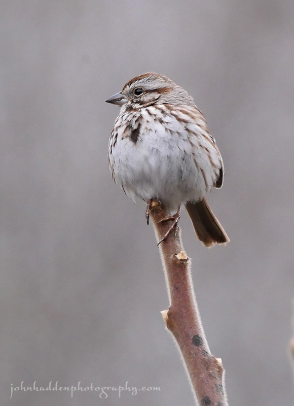
Monday, April 16, 2018


A song sparrow doing its thing
Morning Observation:
This morning in Huntington at 8:00AM it’s currently 35 degrees and windy under overcast skies. Winds are out of the west at 10-15 mph and gusting to 35 mph. Relative humidity is 77%, dewpoint 28m, barometric pressure 30.03” and falling rapidly. We picked up another 0.12” of frozen rain pellets in the rain gauge, a bit more icing, and have 1” hard frozen surface at the snow stake. Yesterday’s high was 32, and the overnight low was 29.
There is a High Wind Warning in effect for our region until 11:00PM tonight.
Forecast:
Deep low pressure slowly moving northeastward out of the Ohio River valley and Great Lakes are kicking up strong and damaging southeast winds across the western slopes of the Greens this morning. Gusts in excess of 60 mph are expected today especially across eastern Addison and Rutland Counties. Elsewhere, winds will generally be 15 to 30 mph with localized higher gusts, as temperatures slowly climb into the 30s and 40s by this afternoon. Periods of rain with pockets of freezing rain east of the Greens will continue today with minimal additional ice accumulation expected. Cooler air developing aloft overnight tonight into Tuesday will produce a mix of rain and snow showers, with some wet snow accumulation possible in the
mountains as the aforementioned low moves over the region. We’ll see a brief break in showery weather Wednesday before a clipper low moves through bringing more showers and mountain flurries Thursday. Unsettled and below average temperaturs will continue for most of the upcoming week.
Today will be windy with periods of rain and areas of freezing rain possible east of the Greens. Highs will be near 40F with ESE winds at 25 to 40 mph gusting to 50 mph locally. Chance of rain is 90%. Tonight should bring showers with winds diminishing overnight. Lows will be around 36F with SE winds at 20 to 30 mph, decreasing to 10 to 15 mph. Chance of rain is 80%.
Tuesday rain and snow in the morning should taper to light rain late. Highs will be around 41F with WSW at 5 to 10 mph. Chance of rain is 70%. Tuesday night rain and snow showers in the evening should transition to snow showers overnight. Lows will be around 30F with SW winds at 5 to 10 mph. Chance of precipitation is 50%.
Wednesday rain and snow in the morning should turn to light rain in the afternoon. Highs will be around 43F with west winds at 10 to 15 mph. Chance of rain is 70%. Wednesday night should be cloudy with lows around 33F and WSW winds at 5 to 10 mph.
Almanac:
Last year on this date we had a high of 81 and a low 49. I took my first pond dip of the season. Today we still have 6″+ of ice on the pond…
Burlington averages for this date are a high of 55 and lows of 35.
The record high was 86°F in 2002 (we had a high of 85).
The record low was 18°F in 1908.
Sky Notes:
Sunrise: 6:07AM
Sunset: 7:37PM
Length of Visible Light: 14h 31m
Length of Day: 13h 30m
Tomorrow will be 2 minutes 55 seconds longer
The Moon is a waxing crescent 0.3 days old with 1% illumination.
Moonrise: 6:49AM
Moonset: 8:22PM
About Today’s Photo:
The song sparrows are out singing once again despite spring’s slow progress. This fine fellow was in good voice in one of the spruce trees by our pond.
Panasonic GX8, Lumix 100-300mm lens @ 300mm, ISO 400, f/8, 1/400″ exposure.
Sunday, April 15, 2018


Willow buds popping in our front field
Morning Observation:
Well, this is an interesting morning… This morning in Huntington at 8:05AM it’s currently 26 degrees under overcast skies. We have frozen rain pellets falling. Relative humidity is 93%, dewpoint 24, barometric pressure 30.47” and rising slowly. We picked up an interesting mix of precipitation: 0.32” of frozen rain pellets in the rain gauge that popped out as a friable plug when I inverted the tube, and there’s about a 0.50” layer of a mix of these pellets and ice at the snow stake. Some flat surfaces have a light glazing of ice on them. I’ve never really seen precipitation like this before. Interesting stuff! Yesterday’s high was 42 (at 3:00AM) and the overnight low was 24.
The Winter Weather Advisory remains in effect for our region until 8:00AM Monday.
There is a High Wind Warning in effect for our region from 4:00AM to 11:00PM Monday.
Forecast:
Challenging weather conditions continue… A slow moving, moisture laden low pressure system approaching from the Ohio River valley will try and nose warmer air into the region today, but high pressure over northern Ontario continues to hold cold air at the surface. This will result in precipitation falling as sleet and freezing rain. Temperatures today will struggle to make it to 32 degrees by day’s end in the broader valleys. We’ll probably see another 0.1″ to 0.2″ of this mix today before the aforementioned low strengthens into tonight finally changing the precipitation to rain late tonight and through Tuesday. Along with the rain, strong gusty winds are expected to impacte the western slopes of the Greens especially in eastern Addison and Rutand counties. Power outages are a strong possibility. By Monday morning we should be seeing all rain with some mountain snow showers. Rain will persist into Wednesday as the aforementioned low passes through the region and finally exits to the east. High pressure should build in briefly for Wednesday night before the next clipper low moves in Thursday into Friday bringing plain old rain and more normal temperatures. Phew!
We’ll see a mix of wintry precipitation throughout the day today. Highs will be around 31F with ESE winds at 10 to 20 mph. Chance of precipitation is 100% with 0.25″-0.50″ of accumulation possible. Precipitation will continue tonight and it will become windy. Lows will be around 28F with ESE at 20 to 30 mph. Chance of precipitation is 70%.
Monday should bring showers in the morning, becoming a steady rain in the afternoon. It will be windy with highs around 38F and ESE at 25 to 35 mph gusting to 60 or 70 mph in the wind warning areas of eastern Chittenden and Rutand counties, and 40 to 50 mph here and farther north. Chance of rain is 80%. Monday night should bring evening rain and wind followed by a mix of rain and snow late over higher elevations. Lows will be around 36F with SE at 20 to 30 mph. Chance of precipitation is 80%.
Tuesday’s looking cloudy with rain and mountain snow showers early changing to mainly rain showers in the afternoon. Highs will be around 42F with SW winds at 5 to 10 mph. Chance of rain is 70%. Tuesday night should bring rain showers with mountain snow showers late. Lows will be near 30F with light and variable winds. Chance of precipitation is 40%.
Almanac:
Last year on this date we had a high of 68 and a low of 28.
Burlington averages for this date are a high of 55 and lows of 35.
The record high was 82°F in 2003 (we had a high of 80).
The record low was 18°F in 1926.
Sky Notes:
Sunrise: 6:09AM
Sunset: 7:36PM
Length of Visible Light: 14h 27m
Length of Day: 13h 27m
Tomorrow will be 2 minutes 55 seconds longer
The Moon is new 28 days old with 0% illumination.
Moonrise: 6:19AM
Moonset: 7:12PM
About Today’s Photo:
Willow buds are starting to pop! Despite a the reprise of wintery conditions, the willows in our front field are forging ahead to spring!
Panasonic GX8, Olympus 60mm macro lens, ISO 1600, f/5.6, 1/800″ exposure.
Saturday, April 14, 2018


Blood root emerging by Fargo Brook
Morning Observation:
This morning in Huntington at 7:40AM it’s currently 33 degrees under overcast skies. Winds are out of the east at 0-5 mph. Relative humidity is 83%, dewpoint 29, barometric pressure 30.13” and rising rapidly. We picked up 0.63” of rain overnight and there are a few ice pellets on the back deck. Yesterday’s high was 49, and the overnight temperature topped out at 40 at 3:00AM and has been dropping since.
A Winter Weather Advisory remains in effect for our region from 8:00AM this morning until 8:00PM Sunday.
Forecast:
An active and complicated weather pattern will be in place across the
region through Monday night. High pressure to our north will push an intensifying cold front southward across the region today, changing rain
early this morning to a mix of snow, sleet, and freezing rain from north to south by early afternoon. The front will stall to our south through early Sunday, keeping wintry mixed precipitation in place across the region. The front will then lift back north as a warm front Sunday afternoon as deep, moisture laden low pressure approaches from the Ohio River valley. This will allow the mixed precipitation to change back over to all rain from the Champlain Valley west by Sunday afternoon with pockets of mixed precipation and icing continuing east. By Sunday morning, we could see 2″-5″ of accumulating snow/sleet from Route 2 north with a trace to 2″ in the Champlain Valley. Icing is also a concern with the potential for power outages from downed trees. Briefly warmer temperatures arrive on Monday with gusty southeast winds, more rain, and the threat for minor flooding on rivers and streams due to the combination of rain and snowmelt.
We’ll see light freezing rain this morning changing over to a wintry mix. Highs will be around 32F with north winds at 10 to 15 mph. Chance of precipitation is 80%. with a trace to 2″ of snow and ice expected. Tonight should be cloudy with snow. Lows will be around 23F with NE winds at 5 to 10 mph. Chance of snow is 100% with 2″ to 4″ of snow expected.
Sunday morning snow should transition to a wintery mix and rain during the afternoon with some icing possible east over higher elevations. Highs will be around around 30F with east winds at 10 to 15 mph. Chance of precipitation is 100% with a trace to 2″ of snow and ice expected. Sunday night should be cloudy with light freezing rain expected. Some icing possible. Lows will be around 27F with ESE winds at 15 to 25 mph. Chance of precipitation is 60%.
Monday should bring freezing rain early transitioning to rain in the afternoon. It will be windy with highs around 39F and ESE winds at 25 to 35 mph. Chance of precipitation is 90%. Monday night should bring occasional rain with some snow mixing in late. Lows will be around 33F with ESE winds at 15 to 25 mph, becoming NNW and decreasing to less than 5 mph. Chance of precipitation is 80%.
Almanac:
Last year on this date we had a high of 60 and a low of 27.
Burlington averages for this date are a high of 54 and lows of 34.
The record high was 84°F in 1968.
The record low was 17°F in 1923.
Sky Notes:
Sunrise: 6:10AM
Sunset: 7:35PM
Length of Visible Light: 14h 24m
Length of Day: 13h 24m
Tomorrow will be 2 minutes 56 seconds longer
The Moon is 27 days old with 3.7% illumination.
Moonrise: 5:50AM
Moonset: 6:04PM
About Today’s Photo:
The patch of blood root along Fargo Brook is starting to emerge, pushing its way up through the soil and moss. This little sprout was about half-an-inch high.
Panasonic GX8, Olympus 60mm macro lens, ISO 1600, f/8, 1/125″ exposure.
Friday, April 13, 2018


Coltsfoot blooming at the top of our driveway
Morning Observation:
This morning in Huntington at 6:45AM it’s currently 43 degrees under overcast skies. Winds are calm. Relative humidity is 91%, dewpoint 41, barometric pressure 29.85” and rising rapidly. We picked up 0.35” of rain in the past 24hrs, and we’re down to bare ground at the stake. Yesterday’s high was 49, and the overnight low was 40.
SOS: Coltsfoot blooming at the top of our driveway!
Herp Alert! With warmer temperatures and damp, rainy nights, amphibians (frogs and salamanders) will be on the move to their breeding grounds in wetlands. Please take extra care when driving at night near wetlands. If you see an amphibian, give it a chance to cross the road (or better yet, help it along). Areas to be careful here in Huntington include: Gillette Pond Road, Hinesburg Hollow Road, upper Delfrate Road, Taft Road.
Forecast:
There is a Winter Weather Advisory (yup…) in effect for our region from 8:00AM Saturday until 8:00PM Sunday.
We’ve got a complicated and pretty messy weather situation ahead of us for the next few days. After a brief break of dry weather this morning, a waffling frontal zone draped along the international border will be the focus of a battle between cold Canadian high pressure to the north and warm, moisture laden low pressure moving in from the southwest. This sets the stage for an extended period of precipitation from this evening into early next week. Rain tonight will transition to mixed precipitation in the form of snow, sleet and freezing rain from north to south on Saturday and continue through Sunday before changing back to rain Sunday night. We could see a bit of accumulation of snow, sleet, freezing rain, and ice through Sunday morning. It’s hard to peg actual amounts as just a bit of extra wiggle to the frontal boundary will make for big differences in precipitation types and amounts. Warmer air should win out by Sunday night into Monday as deep low pressure approaching from the Ohio River valley brings locally heavy rain Monday. A cold front will transition precipitation back to a rain/snow mix Monday night through Tuesday. Like I said, complex and messy. It should be in interesting ride. Buckle up!
We’ll see cloudy skies today with occasional rain showers this afternoon. Highs will be near 50F with WNW winds at 10 to 15 mph. Chance of rain is 60%. Tonight should bring periods of rain. Lows will be around 32F with NNE winds at 5 to 10 mph. Chance of rain is 100% with rainfall around 0.50″.
Saturday should bring periods of mixed winter precipitation. Highs will be around 35F with north winds at 5 to 10 mph. Chance of precip is 90% with 1″ to 3″ of snow, sleet, and ice expected. Saturday night should bring snow in the evening with lingering snow showers overnight. Lows will be around 25F with NE winds at 5 to 10 mph. Chance of snow is 90% with snow accumulations of 3″ to 5″.
Sunday should bring periods of mixed winter precipitation. Highs will be around 30F with east winds at 10 to 15 mph. Chance of precipitation is 90% with snow and ice accumulations of 1″ to 3″. Sunday night should bring plain rain with pockets of freezing rain in the cold pockets. Lows will be around 28F with ESE winds at 10 to 20 mph. Chance of precipitation is 90%.
Almanac:
Last year on this date we had a high of 56 and a low of 32.
Burlington averages for this date are a high of 54 and lows of 34.
The record high was 84°F in 1945.
The record low was 16°F in 1914.
Sky Notes:
Sunrise: 6:12AM
Sunset: 7:34PM
Length of Visible Light: 14h 21m
Length of Day: 13h 21m
Tomorrow will be 2 minutes 57 seconds longer
The Moon is a waning crescent, 26.7 days old with 9% illumination.
Moonrise: 5:22AM
Moonset: 4:57PM
About Today’s Photo:
Coltsfoot is one of the very first wildflowers to bloom here in the spring. This hardy relative of dandelions prefers disturbed soils, and you’ll often find it along roadways and stream banks. It’s a welcome harbinger of spring!
iPhone 6S
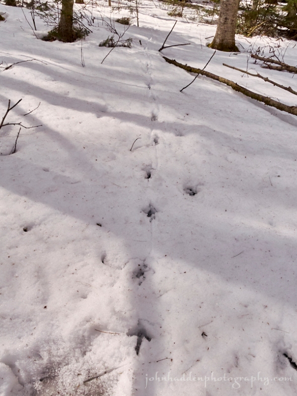
Thursday, April 12, 2018


Grouse tracks and wing prints in fresh snow
Morning Observation:
This morning in Huntington at 7:10AM it’s currently 31 degrees under partly cloudy skies. Winds are calm. Relative humidity is 94%, dewpoint 29, barometric pressure 30.05” and rising slowly. We’re down to our last inch of snow at the stake, but the yard it pretty much bare. Yesterday’s high was 45, and the overnight low was 30.
Signs of Spring: our woodcock returned last evening. He’s a bit tardy but it’s nice to have him back. Spring can really start now…
Forecast:
We’ve got an active and potenially messy weather scene ahead of us going into the weekend. After a brief break of dry weather this morning, low pressure moving into the Great Lakes this morning will track northeast through the Ottawa and St. Lawrence valleys dragging a warm front into the region this afternoon. Light rain will develop across northern New York this morning and eastward across Vermont during the mid to late afternoon hours. Another brief period of drier conditions will follow for tonight into early Friday before an the next moisture laden low pressure system pulls in Friday night. There will be a bit of a battle between the warm air of this low and cold Canadian high pressure to the north that will set up a sharp temperature gradient right over our region. Temperatures could diverge as much as 15 to 20 degrees either side of this gradient making for a challenging forecast situation. We’re expected to be right on the cusp here in Huntington. We should see periods of rain Friday afternoon and night, followed by rain and mixed wintry precipitation Saturday through Sunday night, and heavy rain and windy conditions on Monday. It could get messy. Stay tuned!
We’ll see partly cloudy skies this morning giving way to cloudy skies and light rain late. Highs will be near 50F with south winds at 10 to 15 mph. Chance of rain is 90%. Tonight should bring rain early with clouds and scattered showers overnight. Lows will be around 38F with SW winds at 10 to 20 mph. Chance of rain is 100% with rainfall around 0.25″.
Friday should bring cloudy skies with a slight chance of a rain shower. Highs will be around around 50F with west winds at 5 to 10 mph. Friday night should be cloudy with periods of rain. Lows will be around 33F with NNE winds at 5 to 10 mph. Chance of rain is 90% with rainfall around 0.25″.
Saturday should bring periods of rain and freezing rain. Highs will be around 36F with north winds at 5 to 10 mph. Chance of precipitation is 90%. Saturday night should bring a mix of rain with periods of freezing rain and some icing possible. Lows will be around 27F with NE winds at 5 to 10 mph. Chance of precipitation is 90%.
Almanac:
Last year on this date we had a high of 58 and a low of 44. We picked up 0.12″ of rain.
Burlington averages for this date are a high of 53 and lows of 34.
The record high was 82°F in 1945.
The record low was 16°F in 1926.
Sky Notes:
Sunrise: 6:14AM
Sunset: 7:32PM
Length of Visible Light: 14h 18m
Length of Day: 13h 18m
Tomorrow will be 2 minutes 57 seconds longer
The Moon is a waning crescent, 25.7 days old with 15% illumination.
Moonrise: 4:53AM
Moonset: 3:53PM
About Today’s Photo:
I went for what might be one last ski up on Lion’s Ridge at Camel’s Hump Nordic yesterday. With spring coming on, there was all kinds of activity recorded in the snow. I saw tracks from turkeys, weasels, mice, bear—all going about their early spring businesses. I followed this ruffed grouse track to where the bird took flight leaving the impression of its wings in the soft snow.
Panasonic GM5, Lumix 12-32mm lens @ 26mm, ISO 400, f/9, 1/1000″ exposure.
Wednesday, April 11, 2018

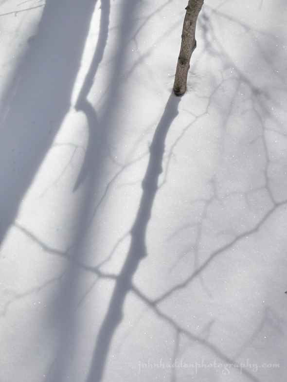
Bright sunlight casts interesting shadows across tthe snow
Morning Observation:
This morning in Huntington at 7:45AM it’s currently 27 degrees under clear skies. Winds are calm. Relative humidity is 95%, dewpoint 26, barometric pressure 30.15” and steady. We have 2” of hard snow at the stake. Yesterday’s high was 42, and the overnight low was 21.
Forecast:
This morning’s clear skies will give way to increasing clouds out ahead of approaching upper level shortwave trough which will bring light rain and snow showers to the region today. A clipper low will then bring widespread rain on Thursday mixing with a few higher elevation snow flurries. Temperatures will continue to moderate with highs today edging towards 50. There is more active weather in store through the weekend and into early next week when a potent low pressure system heads in our direction out of the central Plains. This will be a fairly complicated affair as the moisture laden low competes with chilly Canadian high pressure to bring a potential mixed bag of precipitation types during the weekend. Stay tuned!
We’ll see sunny skies this moring giving way to cloudy skies this afternoon with a slight chance of some light rain later in the day—mostly in the ‘Dacks. Highs will be around 46F with SSW winds at 10 to 15 mph. Tonight should be cloudy with a slight chance of showers. Lows will be around 32F with SSW winds at 5 to 10 mph.
Thursday should start out partly cloudy during the morning hours giving way to cloudy skies and rain in the afternoon. Highs will be near 50F with south at 10 to 15 mph. Chance of rain is 90%. Thursday night should be cloudy with periods of rain early. Lows will be around 39F with south winds shifting to WNW at 10 to 20 mph. Chance of rain is 90%.
Friday’s looking cloudy with showers. Highs will be around 46F with NW winds at 5 to 10 mph. Chance of rain is 60%. Friday night should bring a steady rain in the evening with showers continuing late. Lows will be around 34F with NNE winds at 5 to 10 mph. Chance of rain is 90% with rainfall around 0.25″.
Almanac:
Last year on this date we had a high of 80(!) and a low of 45.
Burlington averages for this date are a high of 53 and lows of 33.
The record high was 84°F in 1945.
The record low was 12°F in 1974.
Sky Notes:
Sunrise: 6:16AM
Sunset: 7:31PM
Length of Visible Light: 14h 15m
Length of Day: 13h 15m
Tomorrow will be 2 minutes 58 seconds longer
The Moon is a waning crescent, 24.8 days old with 23% illumination.
Moonrise: 4:22AM
Moonset: 2:50PM
About Today’s Photo:
There’s still quite a bit of snow up in the high country with a good foot or more of base up at the 1800′ level. While skiing the other day up at Camel’s Hump Nordic, I was stuck by the intensity of the sunshine and the strong shadows it cast across the snow.
Panasonic GM5, Lumix 12-32mm lens @ 32mm, ISO 400, f/10, 1/1000″ exposure
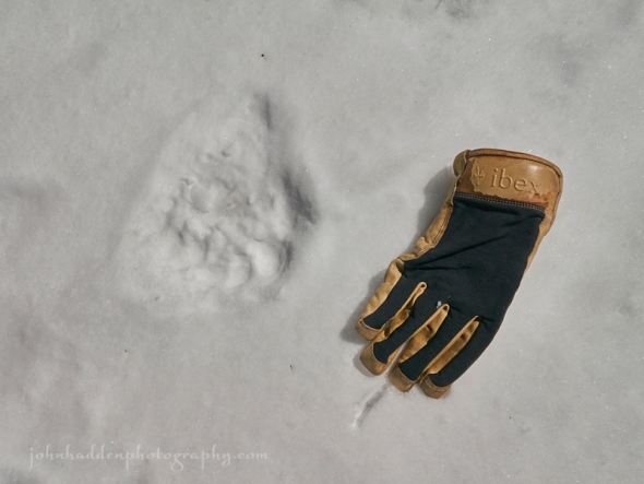
Tuesday, April 10, 2018


Bear tracks in the snow up at Camel’s Hump Nordic
Morning Observation:
This morning in Huntington at 7:40AM it’s currently 24 degrees under partly cloudy skies. Winds are calm. Relative humidity is 86%, dewpoint 21, barometric pressure 30.19” and steady. We’ve got 2” of firm snow still at the stake. Yesterday’s high was 37, and the overnight low was 20.
Forecast:
A series of upper level shortwaves troughs will track just south of our region today bringing some scattered light rain or mainly snow showers. High pressure will build in briefly Wednesday bringing dry conditions. A clipper low will track out of the Great Lakes on Thursday and slide just north of the border bringing another round of rain ans snow showers. Temperatures, while still below seasonal averages, will begin to moderate by the end of the week.
We’ll see mostly cloudy skies today with a few flurries or snow showers possible this afternoon. Highs will be around 42F with west winds at 5 to 10 mph. Tonight should be partly cloudy with lows around 28F and light and variable winds.
Wednesday should be partly cloudy early, then becoming cloudy later in the day. Highs will be near 45F with SSW winds at 10 to 15 mph. Wednesday night should be cloudy early with partial clearing late. Lows will be around 31F with SSW winds at 5 to 10 mph.
Thursday should start off partly cloudy during the morning hours, giving way to cloudy skies and rain in the afternoon. Highs will be around 47F with south winds at 10 to 15 mph. Chance of rain is 90%. Thursday night should bring steady light rain in the evening with showers continuing late. Lows will be around 37F with SW winds at 10 to 15 mph. Chance of rain is 90%.
Almanac:
Last year on this date we had a high of 78 and a low of 41.
Burlington averages for this date are a high of 52 and lows of 33.
The record high was 81°F in 1945.
The record low was 16°F in 1975.
Sky Notes:
Sunrise: 6:17AM
Sunset: 7:30PM
Length of Visible Light: 14h 12m
Length of Day: 13h 12m
Tomorrow will be 2 minutes 59 seconds longer
The Moon is a waning crescent, 24 days old with 31% illumination.
Moonrise: 3:48AM
Moonset: 1:50PM
About Today’s Photo:
I came across this set of bear tracks skiing yesterday morning up at Camel’s Hump Nordic (where there is still quite a lot of snow!) With bears awake now, it’s important to bring your bird feeders in for the season as you don’t want to attract them. As the saying goes, “a fed bear is a dead bear”, as any bear that become habituated to easy human provided food will quickly be deemed a “nuisance” and have to be put down by Fish & Game officers…
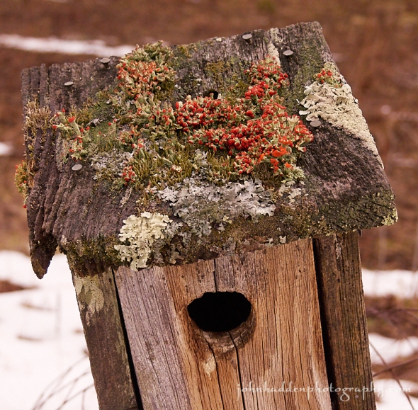
Here’s a close up of one of the tracks with my glove for scale:
Monday, April 9, 2018

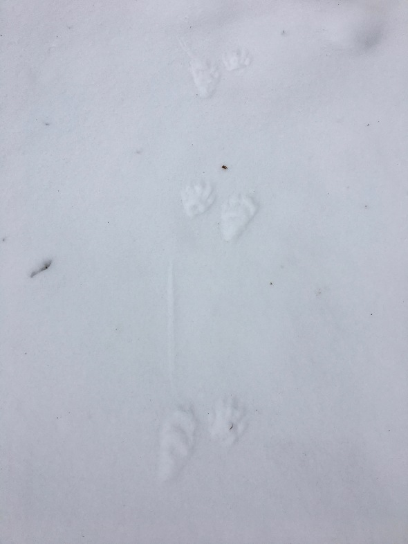
A nice set of racoon tracks in fresh snow
Morning Observation:
This morning in Huntington at 7:30AM it’s currently 15 degrees under clear skies. Winds are calm. Relative humidity is 83%, dewpoint 11, barometric pressure 30.14” and rising rapidly. We picked up 0.50” of new snow yesterday evening and have 2.5” at the stake. Yesterday’s high was 34, and the overnight low was 14.
Forecast:
High pressure building into the region today will deliver continued cold temperatures today along with clear skies this morning. Clouds will begin to build in this afternoon out ahead of a weak shortwave trough that will bring scattered rain and snow showers Tuesday, particularly over the mountains. Surface high pressure will build in Wednesday. The next best chance for widespread precipitation will arrive on Thursday as a clipper low tracks eastward out of the Great Lakes. Temperatures will remain on the cool side through the first half of the week before moderating to more seasonable levels by the weekend.
We’ll see clear skies giving way to partly cloudy skies this afternoon. Highs will only be around 38F with NW winds at 5 to 10 mph. Tonight should be mostly cloudy with lows near 25F and light and variable winds.
Tuesday should be overcast with a few mountain flurries or snow showers possible. Highs will be around 42F with light and variable winds. Tuesday night should be partly cloudy early, giving way to generally clear skies overnight. Lows will be around 26F with light and variable winds.
Wednesday’s looking partly cloudy in the morning followed by cloudy skies in the afternoon. Highs will be around 47F with SW winds at 5 to 10 mph. Wednesday night should be mostly cloudy with lows around 32F and SSW winds at 5 to 10 mph.
Almanac:
Last year on this date we had a high of 63 and a low of 24. We picked up 0.01″ of rain and were down to bare ground at the stake finally ending the snow season.
Burlington averages for this date are a high of 51 and lows of 32.
The record high was 76°F in 1945.
The record low was 14°F in 1997.
Sky Notes:
Sunrise: 6:19AM
Sunset: 7:29PM
Length of Visible Light: 14h 9m
Length of Day: 13h 9m
Tomorrow will be 2 minutes 59 seconds longer
The Moon is a waning crescent, 23 days old with 40% illumination.
Moonrise: 3:10AM
Moonset: 12:52PM
About Today’s Photo:
Racoons are on the prowl. We came across this nice set of tracks walking the path between our neighbor’s house and ours yesterday afternoon. You can clearly make out the hand-like front paws next to the longer rear paws as this racoon ambled along in a slow 2×2 walk.
iPhone 6S
Sunday, April 8, 2018

A song sparrow perches on a sumac branch in our front field
Morning Observation:
This morning in Huntington at 7:20AM it’s currently a frosty 18 degrees under clear skies. Winds are calm. Relative humidity is 91%, dewpoint 16, barometric pressure 29.91” and steady. We’re back to 2” of frozen snow at the stake. Yesterday’s high was 41, and the overnight low was 18.
Forecast:
Morning sunshine will give way to clouds and a spotty sprinkle or flurry this afternoon as a weak cold front swings through the region this afternoon. High pressure will then dominate the weather through the middle of next week though chilly temperatures will continue today into Monday before a slow moderation is expected from Tuesday onward towards the end of the week. The next chance of precipition will arrive Thursday into Friday as low pressure moves in from the Great Lakes.
We’ll see a mix of clouds and sun during the morning giving way to cloudy skies this afternoon. A few flurries or snow showers possible across northern mountains. Highs will top out around 36F with NW winds at 10 to 15 mph. Tonight should be partly cloudy with lows near 20F and NW winds at 5 to 10 mph.
Monday should be mostly sunny with highs near 40F and NW winds at 5 to 10 mph. Monday night should be cloudy with lows around 27F and light and variable winds.
Tuesday’s looking cloudy with highs around 44F and WSW winds at 5 to 10 mph. Tuesday night should be mostly clear with lows around 26F and light and variable winds.
Almanac:
Last year on this date we had a high of 38 and a low of 28. We picked up 0.25″ of rain and 3″ of snow and had 3″ at the stake.
Burlington averages for this date are a high of 51 and lows of 32.
The record high was 73°F in 1991.
The record low was 11°F in 1972.
Sky Notes:
Sunrise: 6:21AM
Sunset: 7:28PM
Length of Visible Light: 14h 6m
Length of Day: 13h 6m
Tomorrow will be 3 minutes 0 seconds longer
The Moon is in its last quarter, 22 days old with 50% illumination.
Moonrise: 2:27AM
Moonset: 11:58AM
About Today’s Photo:
The song sparrows returned a few days ago. I haven’t been able to get a decent shot of one so far this time around, so I’ve taken the liberty to dip into the archives to grab this one taken last season.
Panasonic GX8, Lumix 100-300mm lens @ 300mm, ISO 1600, f/7.1, 1/400″ exposure.
Saturday, April 7, 2018

Despite the snow, our daffodils are pushing through!
Morning Observation:
This morning in Huntington at 8:50AM it’s currently 30 degrees under partly cloudy skies. Winds are out of the west at 3-7 mph. Relative humidity is 64%, dewpoint 19, barometric pressure 29.75” and rising slowly. We picked up 1.25” of snow in the past 24hrs and have 3.5” at the stake. Yesterday’s high was 37, and the overnight low was 28.
Forecast:
High pressure will build into the region today with some gusty morning winds and partly sunny skies. Sunday should be seasonably cold with perhaps a few mountain flurries or light snow showers as weak trough passes through. Additional chances for a few rain or snow showers return to the area for Tuesday and again by late next week. We should, however, begin to see a welcomed moderation in temperatures to more seasonable levels from mid-week onward.
We’ll see partly cloudy skies today with a few flurries or snow showers possible. Highs will be around 37F with WNW winds at 10 to 20 mph. Tonight should be partly cloudy with lows around 22F and west winds at 5 to 10 mph.
Sunday should be partly cloudy in the morning and become cloudy later in the day. Highs will be near 35F with NW winds at 10 to 15 mph. Sunday night should be partly cloudy with lows around 20F and NW winds at 10 to 15 mph.
Monday’s looking partly cloudy with highs around 40F and NW winds at 10 to 15 mph. Monday night should be cloudy with lows around 27F and light and variable winds.
Almanac:
Last year on this date we had a high of 43 and a low of 33. We picked up 0.93″ of rain and were down to bare ground at the stake.
Burlington averages for this date are a high of 50 and lows of 32.
The record high was 83°F in 1991.
The record low was 2°F in 1972.
Sky Notes:
Sunrise: 6:23AM
Sunset: 7:26PM
Length of Visible Light: 14h 2m
Length of Day: 13h 3m
Tomorrow will be 3 minutes 0 seconds longer
The Moon is waning gibbous, 21 days old with 59% illumination.
Moonrise: 1:40AM
Moonset: 11:07AM
About Today’s Photo:
What’s a little April snow to what should soon be our “flock of golden daffodils”? Come on spring!
Panasonic GX8, Olympus 60mm macro lens, ISO 100, f/8, 1/320″ exposure.
Friday, April 6, 2018

A fine set of turkey tracks in the Audubon woods
Morning Observation:
This morning in Huntington at 7:20AM it’s currently 18 degrees under partly cloudy skies. Winds are calm. Relative humidity is 87%, dewpoint 15, barometric pressure 30.03” and falling slowly. We have 2.5” of hard snow at the stake. Yesterday’s high was 34, and the overnight low was 16.
Forecast:
Low pressure moving out out of the northern Great Lakes this morning will track just north of the St. Lawrence lifting a warm from through the region today. We’ll see clouds building this morning and a snow/rain mix arrive midday into the ealy evening. Snow accumulation should be light to nil in the Champlain Valley where “warmer” temperatures should make for a moslty rain event. 1″-4″ of wet snow are likely over higher elevations of the ‘Dacks and northern Greens. Precipitation will quickly drop off this evening as a cold front swings through ushering in gusty winds and drier air. Surface high pressure will build in for Saturday afternoon into Sunday.
We’ll see partly cloudy skies early then becoming cloudy with periods of snow or valley rain this afternoon. Highs will be around 37F with south winds at 10 to 20 mph. Chance of snow is 80% with 1″ to 3″ of snow expected—higher amounts in the northern mountains. Rain and snow will tapering off this evening along with decreasing cloudiness overnight as the aforementioned cold front swings through. Lows will be around 28F with SW winds at 10 to 20 mph. Chance of precipitation is 50%.
Saturday should bring a mix of clouds and sun in the morning followed by cloudy skies during the afternoon with a few flurries or snow showers possible. Highs will be around 38F with west winds at 10 to 20 mph. Saturday night should be partly cloudy with lows around 22F and WNW winds at 5 to 10 mph.
Sunday’s looking partly cloudy early, then becoming cloudy later in the day. Highs will be around 34F with NW winds at 10 to 15 mph. Sunday night should be partly cloudy with lows around 21F and NW winds at 5 to 10 mph.
Almanac:
Last year on this date we had a high of 43 and a low of 39. We had 1″ of snow at the stake.
Burlington averages for this date are a high of 50 and lows of 31.
The record high was 77°F in 1928.
The record low was 10°F in 1943.
Sky Notes:
Sunrise: 6:25AM
Sunset: 7:25PM
Length of Visible Light: 13h 59m
Length of Day: 13h 0m
Tomorrow will be 3 minutes 1 seconds longer
The Moon is waning gibbous, 20 days old with 68% illumination.
Moonrise: 12:47AM
Moonset: 10:21 AM
About Today’s Photo:
We came across this nice set of turkey tracks in Audubon Nature Center woods the other day. They were making a beeline for somewhere—perhaps a tom on the prowl as it’s mating season for these large birds.
Panasonic GX8, Lumix 14-140mm lens @ 14mm, ISO 800, f/18, 1/400″ exposure.
Thursday, April 5, 2018

Sprouting life (knotweed?) along the Huntington River
Morning Observation:
This morning in Huntington at 7:25AM it’s currently a brisk and breezy 19 degrees under clear skies. Winds are out of the west at 5-8 mph. Relative humidity is 57%, dewpoint 6, barometric pressure 29.89” and rising rapidly. We picked up 0.52” of rain in the past 24hrs and have 2.5” of snow at our stake (lots of bare ground around though…) Yesterday’s high was 47, and the overnight low was 18.
Forecast:
The low pressure system that delivered yesterday’s gusty winds is moving into the Canadian Maritimes this morning. High pressure will build in briefly today bringing dry conditions, sunshine, and gusty northwest winds albeit not as strong as yesterday. Fast moving low pressure approaching fron the Great Lakes on Friday will deliver another round of precipitation. Depending on temperature profiles, we may see a dusting to an inch of snow in the Champlain Valley with 2″-4″ in the mountains. If temperatures are just a wee bit warmer, valley locations will see mostly rain along with mountain snow showers. Partly cloudy skies are on tap for Saturday as a weak ridge of high pressure begins to build in for Sunday into the beginning of next week. Temperatures look to be below seasonal averages into next week.
We’ll see generally sunny skies today with highs struggling to make it to 32F along with WNW winds at 15 to 25 mph. Tonight should be czlear to partly cloudy with lows near 20F and WSW winds at 10 to 20 mph.
Friday should be cloudy with periods of snow or rain during the afternoon. Highs will be around 36F with south winds at 10 to 15 mph. Chance of precipitation is 80% with about 1″ of snow expected in the Champlain Valley with perhaps 2″-4″ in northern mountains. Friday night should be cloudy early, followed by partial clearing. A few lingering flurries or snow showers are possible. Lows will be around 27F with WSW winds at 10 to 15 mph.
Saturday’s looking overcast with highs around 38F and WNW winds at 10 to 15 mph. Saturday night should be partly cloudy with lows near 20F and NW winds at 5 to 10 mph.
Almanac:
Last year on this date we had a high of 48 and a low of 36. We had 2″ of snow at the stake.
Burlington averages for this date are a high of 49 and lows of 31.
The record high was 75°F in 1928.
The record low was 3°F in 1964.
Sky Notes:
Sunrise: 6:26AM
Sunset: 7:24PM
Length of Visible Light: 13h 56m
Length of Day: 12h 57m
Tomorrow will be 3 minutes 1 seconds longer
The Moon is waning gibbous, 19.5 days old with 77% illumination.
No Moonrise
Moonset: 9:40AM
About Today’s Photo:
Walking along the Huntington River at the Audubon Nature Center the other day, we came across this one bit of life poking its head through the silt near the river bank. Unfortunately, I’m pretty sure it’s Japanese knotweed. Leave it to an invasive species to be first out of the gate…
Panasonic GX8, Lumix 14-140mm lens @ 125mm, ISO 800, f/8, 1/100″ exposure.
Wednesday, April 4, 2018

British Soldier fungi in formation atop one of our bluebird house
Morning Observation:
This morning in Huntington at 8:15AM it’s currently 40 degrees and raining steadily under overcast skies. Winds are calm. Relative humidity is 95%, dewpoint 39, barometric pressure 29.39” and falling rapidly. We picked up 0.09” of rain overnight and have 3” of snow at the stake. Yesterday’s high was 49, and the overnight low was 38.
There is a a Wind Advisory in effect from 5:00PM today until 5:00AM Thursday.
Forecast:
Low pressure moving out of the Great Lakes this morning will deliver rain and possibly some rumbles of thunder across much of the region this morning with precipitation ending from west to east this afternoon as a cold front sweeps through. The front will usher in strong southwest winds across the area late this afternoon and through the first half of tonight. Wind gusts of 40 to 50 mph will be common but as high as 60 mph out across the Saint Lawrence Valley of New York. Be prepared for the possibility of power outages. Colder and drier air moves in tonight and Thursday with daytime high temperatures expected to be only in the 30s. The next storm system will approach the region late Thursday night into Friday. Below average temperatures will support snow over the entire area with accumulations expected to be around 1″ to 2″ in the Champlain Valley and to 2″ to 4″ over the mountains. Drier and more settled conditions should arrive for the weekend.
We’ll see periods of rain rain today with windy conditions in the afternoon. Highs will be around 49F with SW winds at 20 to 30 mph. Chance of rain is 90% with rainfall near 0.25″. Tonight should be mostly cloudy and windy with a few flurries or snow showers possible. Lows will drop to around 17F with west winds at 25 to 35 mph.
Thursday should be partly cloudy with high only near 30F and WNW winds at 15 to 25 mph. Thursday night should be partly cloudy with a few flurries or snow showers possible. Lows will be around 21F with WSW winds at 10 to 20 mph.
Friday snow is likely. Highs will be around 38F with south winds at 10 to 15 mph. Chance of snow is 90% with 1″ to 2″ expected in the Champlain Valley and to 2″ to 4″ over the mountains. Friday night should be mostly cloudy with lingering snow showers around in the evening. Lows will be around 27F with SW winds at 5 to 10 mph. Chance of snow is 40%.
Almanac:
Last year on this date we had a high of 50 and a low of 38. We had 4″ of snow at the stake.
Burlington averages for this date are a high of 49 and lows of 30.
The record high was 73°F in 1974.
The record low was 6°F in 1911.
Sky Notes:
Sunrise: 6:28AM
Sunset: 7:23 PM
Length of Visible Light: 13h 53m
Length of Day: 12h 54m
Tomorrow will be 3 minutes 1 seconds longer
The Moon is waning gibbous, 18.5 days old with 84% illumination.
Moonrise: 11:51PM
Moonset: 9:03AM
About Today’s Photo:
While cleaning out our bluebird houses the other day, I came across this phalanx of British Soldier fungi encamped atop one of them. Is suppose even bluebirds (or potentially tree swallows) like a bit of color on their abodes…
Panasonic GX8, Lumix 14-140mm lens @ 28mm, ISO 640, f/4.3, 1/600″ exposure.
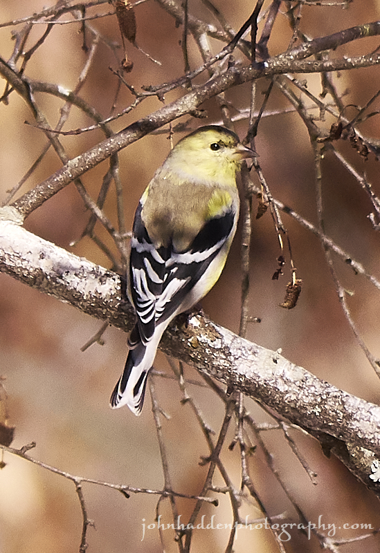
Tuesday, April 3, 2018

Brightening plumage on a male goldfinch
Morning Observation:
This morning in Huntington at 7:15AM it’s currently 32 degrees under partly cloudy skies. Winds are calm. Relative humidity is 80%, dewpoint 26, barometric pressure 30.12” and steady. We still have 5” of solid snow at the stake. Yesterday’s high was 44, and the overnight low was 27.
Forecast:
We’ve got an active weather pattern setting up for the remainder of the week. Low pressure approaching from the Great Lakes will lift a warm front into the region later today bringing widespread rain and some mountain snow to the area. A strong cold front will then sweep across the region on Wednesday bringing another round of widespread showers to the area with the possibility of a few thunderstorms. Behind the front Wednesday afternoon and evening strong west to southwest winds are expected to develop across the region. Many locations will see wind gusts in the 35 to 45 mph range with gusts of 50 to 60 mph possible across northern New York and southern Vermont. Colder and drier air moves in for Thursday with below normal
temperatures expected. Another storm system moves back into the region late Thursday night and Friday for more rain and snow.
We’ll see cloudy skies with periods of light rain this afternoon. Highs will be around 46F with south winds at 5 to 10 mph. Chance of rain is 80%. Tonight should bring periods of rain. Lows will be around 36F with SE winds at 10 to 20 mph. Chance of rain is 90% with rainfall around 0.25″-0.50″.
Wednesday will bring persistent rain and it will become windy in the afternoon. Highs will top out in the mid 50s with SSW winds at 20 to 30 mph. Chance of rain is 100% with rainfall amounts around 0.50″-0.75″. Winds could occasionally gust over 40 mph. Wednesday night should be cloudy with gusty winds and a few flurries or snow showers possible. Lows will be around 17F with west winds at 20 to 30 mph.
Thursday should be partly cloudy with high only around 31F and WNW winds at 10 to 20 mph. Thursday night should start out partly cloudy giving way to cloudy skies overnight with a few flurries or snow showers possible. Lows will be around 22F with SW winds at 10 to 15 mph.
Almanac:
Last year on this date we had a high of 54 and a low of 24. We had 6″ of snowe at the stake.
Burlington averages for this date are a high of 48 and lows of 30.
The record high was 82°F in 2010 (we had a high of 83).
The record low was 7°F in 1911.
Sky Notes:
Sunrise: 6:30AM
Sunset: 7:21PM
Length of Visible Light: 13h 50m
Length of Day: 12h 51m
Tomorrow will be 3 minutes 2 seconds longer
The Moon is waning gibbous, 17.5 days old with 91% illumination.
Moonrise: 10:50PM
Moonset: 8:29AM
About Today’s Photo:
We’ve had quite a herd of goldfinches with us all winter long. Now that breeding season is approaching, the plumage of the male finches is starting to brighten up as they molt their drab winter colors. In a few weeks this little fellow will be bright yellow!
Panasonic GX8, Lumix 100-300mm lens @ 300mm, ISO 800, f/9, 1/1000″ exposure.
