Friday, November 30, 2018


A red squirrel pauses briefly in the hemlock near our bird feeders
Morning Observation:
This morning in Huntington at 7:25AM it’s currently 30 degrees under overcast skies. Winds are calm. Relative humidity is 97%, dewpoint 29, barometric pressure 30.03” and rising slowly. We have 14.5” of snow at the stake. Yesterday’s high was 34, and the overnight low was 29.
Forecast:
High pressure tracking across the region today will deliver dry conditions through the day on Saturday. A weak upper level disturbance could bring an isolated snow shower or two to southern Vermont this afternoon but will
quickly exit to our west before midnight. Things will start getting messy Saturday night as a strengthening low pressure system tracks out of the Ohio River valley and into New England. We’ll see snow and sleet to kick things off, transitioning to freezing rain and finally rain late Saturday night into Sunday as a potent warm front moves in. Showery weather will likely continue into next week as the low remains entrenched across the region.
We’ll see cloudy skies today with a high near 33 and calm winds. Tonight should be cloudy with a low around 26 and light and variable winds.
Saturday should start out partly sunny with a high near 34 and light and variable winds. Saturday night sleet and snow are likely before 3:00am, transitioning to rain after 4:00am. It’ll be mostly cloudy with a low around 29 and southeast winds 6 to 9 mph. Chance of precipitation is 70%. with snow and sleet accumulations of less than 1/2″ possible.
Sunday rain is likely. Highs will be near 42 with southeast winds 9 to 16 mph. Chance of precipitation is 80%. Sunday night should bring a 50% chance of showers. It’ll be mostly cloudy with a low around 37 and south winds around 7 mph.
Almanac:
Last year on this date we had a high of 46 and a low of 16. We picked up 0.17″ of rain and 0.05″ of snow.
Burlington averages for this date are a low of 26 and a high of 39.
The record low was -2 in 1958.
The record high was 63 in 2006 (we had a high of 64).
Sky Notes:
Sunrise: 7:06AM
Sunset: 4:14PM
Length of day: 9:07:58
Today will be 1:33 shorter than yesterday.
About Today’s Photo:
There was a bit of a line in squirrel-land the other morning as this little guy waited his turn for a chance at one of our feeders.
Panasonic GX8, Lumix 100-300mm lens @ 246mm, ISO 800, f/8, 1/200″ exposure.
Thursday, November 29, 2018

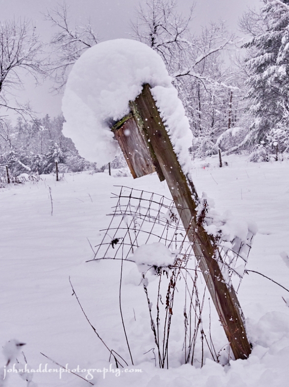
A snow laden bluebird house in our front field
Morning Observation:
This morning in Huntington at 7:40AM it’s currently 32 degrees under overcast skies. Winds are calm, and it’s actually stopped snowing! Relative humidity is 95%, dewpoint 31, barometric pressure 29.79” and rising rapidly. We picked up an additional 5” of new snow in the past 24hrs and have 17” at the stake. Our storm total is 20.5”. Not bad for November! Yesterday’s high was 34, and the overnight low was 32.
Forecast:
High pressure building into the region this morning will deliver dry conditions with slightly below normal temperatures can be expected today into Friday. A warming trend is expected this weekend with the next chance for widespread precipitation arriving Saturday night as low pressure over the midwest pushes a warm front into the northeast. Most areas will see some wet snow at the onset, which will quickly transition to mixed precipitation through Saturday night and then become mainly rain through Sunday morning. Temperatures Sunday should bump into the mid 40s regionwide.
We may see a few lingering snow showers this morning. It’ll be mostly cloudy with a high near 34 and northwest winds 9 to 11 mph. Tonight should be mostly cloudy with a low around 27 and northwest winds 3 to 8 mph.
Friday should be mostly cloudy with a high near 33 and calm winds. Friday night should be mostly cloudy with a low around 24 and calm winds.
Saturday’s looking mostly sunny to start the day with a high near 35 and light and variable wind. Saturday night rain and snow showers should spread over the region, transitioning to rain by daybreak. Lows will be around 29 with southeast winds 5 to 9 mph. Chance of precipitation is 80% with precipitation amounts between 1/10″ and 1/4″ possible.
Almanac:
Last year on this date we had a high of 49 and a low of 22. We were down to bare ground at the stake.
Burlington averages for this date are a low of 26 and a high of 40.
The record low was 7 in 1978.
The record high was 65 in 2005 (we had a high of 60).
Sky Notes:
Sunrise: 7:05AM
Sunset: 4:14PM
Length of day: 9:09:32
Today will be 1:37 shorter than yesterday.
The Moon is waning gibbous, 21 days old with 57% illumination.
Moonrise: 11:24PM
Moonset: 12:25PM
About Today’s Photo:
Snow on snow on snow! This uncanny November snowfall makes it feel like we’re in the middle of January (on a good year…) One of the bluebird houses in our front field sports a thick mantle of dense snow.
Panasonic GX8, Lumix 14-140mm lens @ 28mm, ISO 1600, f/5.6, 1/4000″ exposure.
Wednesday, November 28, 2018


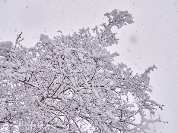
Sticky snow coats birch twigs in our front yard
Morning Observation:
This morning in Huntington at 7:45AM it’s currently 32 degrees and snowing lightly under overcast skies. Winds are calm. Relative humidity is 97%, dewpoint 31, barometric pressure 29.28” and rising slowly. We picked up a whopping 12.5” of heavy dense snow in the past 24hrs and have 15” at the stake—a hands-down record for this time of year. Yesterday’s high was 37, and the overnight low was 31.
A Winter Weather Advisory remains in effect for our region until 7:00PM tonight.
Forecast:
Low pressure near the Maine and New Hampshire border this morning will continue to rotate Light accumulating snows across northern counties today as it drifts slowly east by Thursday. High pressure will build in briefly Thursday night bringing dry and seasonable weather for Thursday night into Saturday before the next chance for rain or mixed precipitation returns Saturday night into Sunday along with a shot of warmer air.
We’ll see continued snow today with highs near 34 and northwest winds 8 to 10 mph. Chance of precipitation is 100% with total daytime snow accumulations of 2″ to 4″ possible. Tonight snow is likely. Lows will be around 30 with northwest winds around 10 mph. Chance of precipitation is 100% with new snow accumulation of 1″ to 3″ possible.
Thursday should bring a 40% chance of lingering snow showers. It’ll be cloudy with a high near 33 and northwest winds 10 to 13 mph. Thursday night should be mostly cloudy with a low around 26 and northwest winds 5 to 9 mph.
Friday’s looking partly sunny with a high near 34 and light northwest winds.
Friday night should be mostly cloudy with a low around 24 and calm winds.
Almanac:
Last year on this date we had a high of 47 a low of 7. We picked up 1.25″ of snow and had 3″ at the stake.
Burlington averages for this date are a low of 27 and a high of 40.
The record low was 3 in 1951.
The record high was 68 in 1990.
Sky Notes:
Sunrise: 7:04AM
Sunset: 4:15PM
Length of day: 9:11:09
Today will be 1:41 shorter than yesterday.
The Moon is waning gibbous, 20.3 days old with 68% illumination.
Moonrise: 10:12PM
Moonset: 11:58PM
About Today’s Photo:
As anyone who’s wielded a snow shovel over the past couple of day knows, this stuff is heavy and sticky. It easily clings to the branches and twigs of the birch in our front yard. Many limbs are bent low—especially conifers—and we’ve seen frequent brief power outages here since the snow started falling. This storm will certainly be going down in the record books!
Panasonic GX8, Lumix 14-140mm lens @ 34mm, ISO 1600, f/5, 1/200″ exposure.
Tuesday, November 27, 2018

Heavy wet snow sticks to branches and twigs
Morning Observation:
This morning in Huntington at 8:00AM it’s currently 33 degrees and snowing steadily under overcast skies. Winds are calm. Relative humidity is 96%, dewpoint 32, barometric pressure 29.40” and falling slowly. We’ve picked up 0.33” of rain/melted precipitation and 3.75” of dense, wet snow in the past 24hrs. We have 5.5” of snow at the stake. Yesterday’s high was 40, and the overnight low was 33.
A Winter Storm Warning remains in effect for our region until 7:00PM this evening.
Forecast:
Steady valley rain/snow and mountains snows will continue today across the region as a coastal low takes shape and deepens near the eastern tip of Long Island this morning. We’ll see significant snow at higher elevations across the region through Wednesday with the mountains seeing up to 2′ while valley locations receive 4″-6″. Given that temperatures will be bobbling around and just above the freezing mark, snowfall will be strongly elevationally dependent. High pressure and dry weather will build in briefly by Friday into Saturday before the next round of rain and snow arrive by next Sunday.
We’ll see snow today. Highs will be near 34 with northeast winds 7 to 10 mph becoming northwesterly in the afternoon and gusting to 21 mph. Chance of precipitation is 100% with total daytime snow accumulations of 3″ to 5″ possible. Tonight snow is likely. Lows will be around 29 with northwest winds around 7 mph. Chance of precipitation is 90% with new snow accumulations of 1″ to 3″ possible.
Wednesday snow is likely before 1:00pm, then rain and snow in the afternoon tapering to snow after by evening. Highs will be near 35 with northwest winds 9 to 11 mph. Chance of precipitation is 90% with new snow accumulation of 1″ to 3″ possible. Wednesday night snow is likely. Lows will be around 29 with northwest winds 8 to 10 mph. Chance of precipitation is 80% with new snow accumulation of less 1″ possible.
Thursday should bring a 40% chance of lingering snow showers before ealy. It’ll be cloudy with a high near 34 and northwest winds 8 to 13 mph gusting to 23 mph. New snow accumulation of less 1/2″ is possible. Thursday night should be mostly cloudy with a low around 26 and northwest winds around 6 mph becoming calm after midnight.
Almanac:
Last year on this date we had a high of 31 and a low of 14.
Burlington averages for this date are a low of 27 and a high of 41.
The record low was -1 in 1957.
The record high was 61 in 2015 (we had a high of 60).
Sky Notes:
Sunrise: 7:03AM
Sunset: 4:15PM
Length of day: 9:12:50
Today will be 1:44 shorter than yesterday.
The Moon is waning gibbous, 19 days old with 79% illumination.
Moonrise: 9:00PM
Moonset: 11:14AM
About Today’s Photo:
This morning’s heavy, wet snow is doing a good job of sticking to branches and twigs of the trees around the house. It’s quite lovely and reminds me a bit of velveted antlers on deer.
Panasonic GX8, Lumix 14-140mm lens @ 21mm, ISO 1600, f/5, 1/320″ exposure.
Monday, November 26, 2018

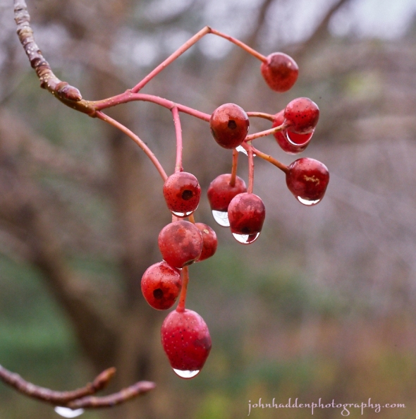
Raindripped ash berries in our front yard
Morning Observation:
This morning in Huntington at 7:40AM it’s currently 34 degrees under mostly cloudy skies. Winds are calm. Relative humidity is 98%, dewpoint 34, barometric pressure 29.90” and falling slowly. We picked up 0.08” of rain in the past 24hrs. We have 3” of snow at the stake. Yesterday’s high was 39, and the overnight low was 33.
There is a Winter Storm Warning in effect for our region from 7:00PM tonight until 7:00PM Tuesday.
Forecast:
We’ve got an active and messy weather pattern heading our way for the first part of the week. Double barrel low pressure—one approaching from the lower Great Lakes and the another tracking inland up the eastern seaboard—will deliver a juicy and sustained shot of mixed precipitation and snow to the region through Thursday. Widespread rain will develop tonight in valley locations with elevations above 1000′ seeing significant snowfall. By the time the lows pull out late Wednesday, we could see 2″-4″ in valley locations and as much as 18″ to 2′ across the summits of the ‘Dacks and Greens. Strong winds will accompany the storm along the western slopes of the Greens as well.
Today rain is likely mainly after 4:00pm. It’ll be cloudy with a high near 39 and light and variable winds becoming southeasterly 9 to 14 mph in the morning and gusting to 26 mph. Chance of precipitation is 70%. Tonight rain is likely before 11:00pm changing to snow late. Lows will be around 32 with a southeast winds 16 to 21 mph becoming northeasterly 10 to 15 mph after midnight and gusting to 38 mph. Chance of precipitation is 100% with snow accumulations of 1″ to 3″ possible.
Tuesday snow is likely early diminishing to snow showers in the afternoon. Highs will be near 37 with north winds 6 to 11 mph becoming westerly in the afternoon and gusting to 23 mph. Chance of precipitation is 100% with new snow accumulations of 2″ to 4″ possible. Tuesday night snow showers are likely. It’ll be cloudy with a low around 27 and west winds 3 to 5 mph. Chance of precipitation is 60% with new snow accumulation of 1″ to 2″ possible.
Wednesday snow showers are likely. It’ll be cloudy with a high near 37 with southwest winds 5 to 8 mph becoming northwesterly in the afternoon. Chance of precipitation is 70% with new snow accumulation of 1″ to 2″ possible. Wednesday night snow showers are likely. It’ll be cloudy with a low around 29 and northwest winds around 7 mph. Chance of precipitation is 70% with only minor additional snow accumulation expected.
Almanac:
Last year on this date we had a high of 43 and a low of 23. We picked up 0.7″ of rain and 1″ of snow and had 1″ at the stake.
Burlington averages for this date are a low of 28 and a high of 41.
The record low was 2 in 1957.
The record high was 64 in 1979.
Sky Notes:
Sunrise: 7:01AM
Sunset: 4:16PM
Length of day: 9:14:35
Today will be 1:47 shorter than yesterday.
The Moon is waning gibbous, 18 days old with 87% illumination.
Moonrise: 7:50PM
Moonset: 10:22AM
About Today’s Photo:
The Korean Mountain Ash in our front yard has a good crop of berries on it again this season. I’ve seen a few robins feasting. I like the way the raindrops (raindrips?) hang from them.
Panasonic GX8, Olympus 60mm macro lens, ISO 800, f/4.5, 1/800″ exposure.
Tuesday, November 20, 2018

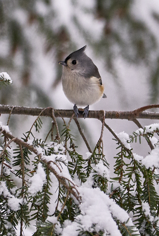
A tufted titmouse feeds in the hemlock by our feeders
Morning Observation:
This morning in Huntington at 7:10AM it’s currently 28 degrees under overcast skies. Winds are calm. Relative humidity is 97%, dewpoint 27, barometric pressure 29.94” and steady. We have 4” of crusty snow at the stake. Yesterday’s high was 41, and the overnight low was 27.
Forecast:
Low pressure moving up the New England coast this morning will deliver light snow across the region today. Most of the area will see less than 2″, but up to 4″ may fall across south central and southern Vermont. Snow will come to an end tonight. A sharp cold front and associated low will move across the region Wednesday bringing snow and snow squalls from about midday into the afternoon as it swings through. Sharply reduced visibilities and bursts of heavy snow will be possible with the snow squalls. Snowfall will end Wednesday night and very cold air will move in for Thanksgiving as high pressure builds into the region. High temperatures should be about 25 degrees below normal for this time of year. A warming trend will arrive going into the weekend with scattered rain showers expected Saturday night into Sunday.
We’ll see snow today mainly after 9:00am. Highs will be near 33 with calm winds becoming northwesterly around 5 mph in the afternoon. Chance of precipitation is 80% with snow accumulation of 1″ to 2″ possible. Tonight should bring a 30% chance of snow showers mainly before 9:00pm. It’ll be cloudy, gradually becoming partly cloudy, with a low around 19 and northwest winds 5 to 7 mph.
Wednesday snow showers are likely, mainly after 2:00pm. The snow could be heavy at times. Highs will be near 28 with southwest winds 6 to 13 mph becoming northwesterly in the afternoon. Chance of precipitation is 80% with snow accumulation of 1″ to 2″ possible. Wednesday night snow showers are likely, mainly before 7:00pm. It’ll be mostly cloudy with a low around 5 and northwest winds around 14 mph gusting to 24 mph. Chance of precipitation is 60%.
Thanksgiving Day should be partly sunny and cold with a high near 14 and northwest winds 14 to 18 mph. Thursday night should be partly cloudy with a low around 4 and northwest winds around 6 mph becoming calm after midnight.
Almanac:
Last year on this date we had a high of 29 and a low of 23. We picked up 4.25″ of snow and 0.11″ of rain.
Burlington averages for this date are a low of 30 and a high of 44.
The record low was 9 in 1959.
The record high was 71 in 1991.
Sky Notes:
Sunrise: 6:54AM
Sunset: 4:20PM
Length of day: 9:26:08
Today will be 2:05 shorter than yesterday.
The Moon is waxing gibbous, 11.7 days old with 90% illumination.
Moonrise: 3:21PM
Moonset: 3:36AM
About Today’s Photo:
Tufted titmice are common visitors to our feeders this time of year. Like their allies, the chickadees, titmice live here year round and often flock with chickadees. On cold winter nights, up to a dozen titmice may share a tree cavity to stay warm. Note the sunflower seed between this bird’s feet.
Panasonic GX8, Lumix 100-300mm lens @ 300mm, ISO 1600, f/5.6, 1/320″ exposure.
Monday, November 19, 2018


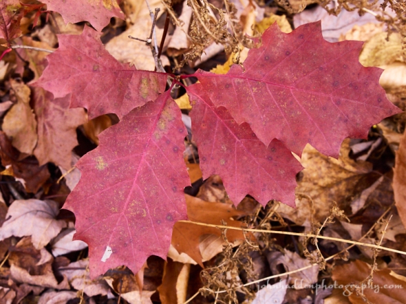
A pair of red oak leaves on snow
Morning Observation:
This morning in Huntington at 7:25AM it’s currently 34 degrees under overcast skies. Winds are calm. Relative humidity is 88%, dewpoint 31, barometric pressure 30.12” and falling slowly. We have 6” of snow at the stake. Yesterday’s high was 31, and the overnight low was 31.
Forecast:
We’ll see below normal temperatures and chances for light snow Tuesday as a weak coastal low moves to our east. A strong upper disturbance moving in from the Great Lakes Wednesday should bring some snow squalls followed by a sharp cold front and strong Arctic airmass. Temperatures on Thanksgiving will be well a good 20 to 25 degrees below normal with highs struggling to reach 20. Conditions should be mostly dry for Thanksgiving. A ridge of high pressure will initiate a warming trend later in the week heading into the weekend.
We’ll see mostly cloudy skies today, with a high near 38 and south winds 5 to 7 mph becoming northwesterly in the afternoon. Tonight should bring a 30% chance of snow showers. It’ll be cloudy with a low around 27 and calm winds.
Tuesday snow showers are likely mainly before noon. It’ll be cloudy with a high near 31 and calm winds becoming northerly around 5 mph. Chance of precipitation is 60% with snow accumulation of 1″ to 2″ possible. Tuesday night should bring a 40% chance of snow showers before 10pm. It’ll be mostly cloudy with a low around 18 and west winds around 6 mph.
Wednesday snow showers are likely in the afternoon. It’ll be mostly cloudy with a high near 28 and southwest winds 5 to 9 mph. Chance of precipitation is 60% with snow accumulations of less 1″ possible. Wednesday night snow showers are likely, mainly before 8:00pm. It’ll be mostly cloudy and cold with a low around 7 and northwest winds around 10 mph. Chance of precipitation is 60%.
Almanac:
Last year on this date we had a high of 52 and a low of 29. We picked up 0.35″ of rain and had no snow at the stake.
Burlington averages for this date are a low of 30 and a high of 44.
The record low was 10 in 1962.
The record high was 67 in 1941.
Sky Notes:
Sunrise: 6:53ASM
Sunset: 4:21PM
Length of day: 9:28:14
Today will be 2:08 shorter than yesterday.
The Moon is waxing gibbous, 10.8 days old with 83% illumination.
Moonrise: 2:55PM
Moonset: 2:31AM
About Today’s Photo:
When seasons bump up against each other, lovely photo opportunities exist. The snowpack in the woods up at Sleepy Hollow Ski Center are strewn with red oak leaves as the last of these late droppers continue to shed their coppery foliage. I was particularly drawn to the drops of water—melted snow—on the surface of the leaves.
Panasonic GM5, Lumix 12-32mm lens @ 32mm, ISO 800, f/8, 1/640″ exposure.
Sunday, November 18, 2018


Snow, open water, and oak leaves up at Sleep Hollow
Morning Observation:
This morning in Huntington at 7:30AM it’s currently a brisk 10 degrees under mostly clear skies. Winds are calm. Relative humidity is 91%, dewpoint 8, barometric pressure 30.39”and rising slowly. We picked up 1.75” of new snow in the past 24hrs and have 7” at the stake. Yesterday’s high was 39, and the overnight low was 9.
Forecast:
Chilly temperatures expected today as high pressure builds in to the region bringing a couple of days of dry conditions. Our next chance for widespread showers will be on Monday night into Tuesday as an arctic cold front sweeps through the region bringing scattered snow showers. Behind that cold front we’ll see well below normal temperatures as we look forward to a rather chilly Thanksgiving holiday. At this point the upcoming weekend looks to be dry with moderating temperatures.
Clouds will be on the increase today with a high near 29 and calm winds becoming southerly around 6 mph in the afternoon. Tonight should bring a 20% chance of snow showers between. It’ll be mostly cloudy with a low around 25 and south winds around 8 mph.
Monday should be mostly cloudy with a high near 37 and south winds 5 to 7 mph becoming calm in the afternoon. Monday night should bring a 40% chance of snow showers after 11:00pm. It’ll be cloudy with a low around 25 and light and variable wind. Little or no snow accumulation expected.
Tuesday should bring a 50% chance of snow showers. It’ll be cloudy with a high near 33 and light and variable winds becoming northwesterly around 6 mph in the afternoon. New snow accumulation of less 1″ possible. Tuesday night should be mostly cloudy with a low around 17 and light west winds.
Almanac:
Last year on this date we had a high of 42 and a low of 15. We had 1″ of snow at the stake.
Burlington averages for this date are a low of 31 and a high of 45.
The record low was 14 in 1956.
The record high was 65 in 1953.
Sky Notes:
Sunrise: 6:51AM
Sunset: 4:22PM
Length of day: 9:30:23
Today will be 2:11 shorter than yesterday.
The Moon is waxing gibbous, 9.8 days old with 75% illumination.
Moonrise: 2:29PM
Moonset: 1:28AAM
About Today’s Photo:
Early snow has brought a boon to skiers (like me!) this season as a wonderful base covers much of the region. Fall doesn’t seem to be completely finished however, as late dropping red oaks are still unloading their leaves. The contrast of snow, open water, and coppery oak leaves is quite lovely up at Sleepy Hollow Ski Center.
Panasonic GM5, Lumix 12-32mm lens @ 21mm, ISO 800, f/13, 1/125″ exposure.
Saturday, November 17, 2018

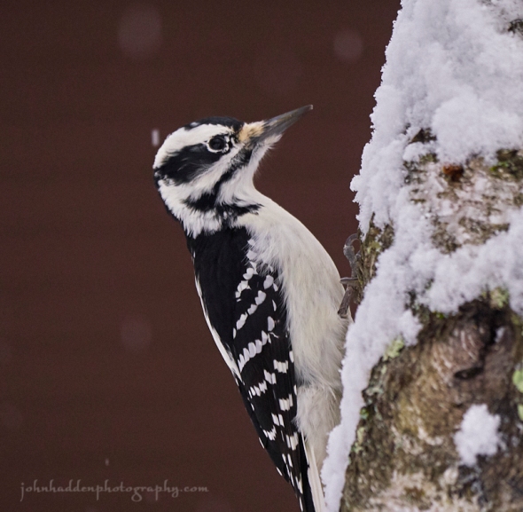
A downy woodpecker on the birch in our side yard
Morning Observation:
This morning in Huntington at 7:50AM it’s currently 32 degrees under overcast skies. Winds are calm.we have a bit of graupel snizzle coming down with a hint of drizzle as well. We picked up 2” of new snow in the past 24hrs and have 6” at the stake. Yesterday’s high was 32, and the overnight low was 31.
Forecast:
An upper level shortwave trough will track across the region today bringing isolated to scattered light mountain snow showers. A sharp cold front will sags south out of Canada bringing chilly air Sunday going into the upcoming week. Quiet weather is expected along with below normal temperatures through the
Thanksgiving holiday.
We’ll see scattered snow showers possibly mixing with rain today before 4:00pm, then scattered snow showers going into the evening. It’ll be partly sunny with a high near 38 and west winds 9 to 11 mph. Chance of precipitation is 30%. Tonight should bring scattered snow showers. It’ll be mostly cloudy with a low around 18 and northwest winds 5 to 9 mph becoming light after midnight. Chance of precipitation is 40%.
Sunday should be mostly sunny with a high near 29 and light and variable winds becoming southwesterly around 5 mph in the afternoon. Sunday night should be mostly cloudy with a low around 23 and south winds around 8 mph.
Monday’s looking mostly cloudy with a high near 35 and southwest winds 3 to 7 mph. Monday night should bring a 30% chance of snow showers late. It’ll be mostly cloudy with a low around 20 and light and variable winds.
Almanac:
Last year on this date we had a high of 33 and a low of 15. We picked up 1″ of snow and had 1″ at the stake.
Burlington averages for this date are a low of 31 and a high of 45.
The record low was 8 in 1972.
The record high was 70 in 2006 (we had a high of 68).
Sky Notes:
Sunrise: 6:50AM
Sunset: 4:23PM
Length of day: 9:32:34
Today will be 2:13 shorter than yesterday.
The Moon is waxing gibbous, 9 days old with 66% illumination.
Moonrise: 2:03PM
Moonset: 12:26AM
About Today’s Photo:
We put up our bird feeders the other day, and almost instantaneously, the chickadees found them and started chattering excitedly. Now the usual suspects are in attendance: chickadees, titmice, bluejays, and this downy woodpecker who’s mostly attracted to our suet feeder. It’s wonderful having them back!
Panasonic GX8, Lumix 100-300mm lens @ 201mm, ISO 1600, f/5, 1/400″ exposure.
Friday, November 16, 2018

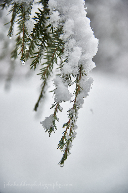
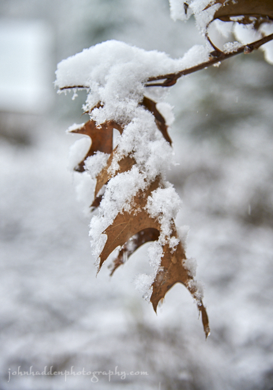
Snow clings to hemlock twigs in our
Morning Observation:
This morning in Huntington at 7:05AM it’s currently 24 degrees and snowing lightly under overcast skies. Winds are calm. Relative humidity is 92%, dewpoint 22, barometric pressure 29.79” and falling rapidly. We picked up 2.5” of sugary snow overnight and have 4” at the stake. Yesterday’s high was 29, and the overnight low was 24.
A Winter Storm Warning remains in effect for our region until 3:00PM this afternoon.
Forecast:
The nor’easter centered over NYC this morning will track up the New England Coast today and continue to produce periods of moderate to heavy snow this morning with widespread 5″ to 10″ expected across our region. The snow should begin to taper off by mid afternoon with another 1″ to 3″ of lingering snow possible through Saturday. High pressure will build in from the Great Lakes Saturday night into Sunday bringing quiet conditions along with well below normal temperatures through Thanksgiving.
We’ll see moderate to heavy snow today before 1:00pm, tapering to snow showers this afternoon. Highs will be near 33 with north winds 5 to 7 mph becoming southerly in the afternoon. Chance of snow is 100% with snow accumulations of 2″ to 4″ possible. Tonight snow showers are likely before 11:00pm then a chance of rain and snow showers between late as warmer air noses in. It’ll be mostly cloudy with a low around 30 and southwest winds 5 to 10 mph. Chance of precipitation is 60% with snow accumulations of less than 1/2″ possible.
Saturday should bring a slight chance of snow showers before 7:00am, then a chance of rain showers after 1:00pm. It’ll be partly sunny with a high near 39 and west winds 8 to 10 mph. Chance of precipitation is 30%. Saturday night should bring a 40% chance of rain and snow showers. It’ll be cloudy, becoming partly cloudy with a low around 22 and west winds around 6 mph becoming light and variable after midnight.
Sunday’s looking mostly sunny with a high near 28 and light and variable winds.
Sunday night should bring 50% chance of light snow. It’ll be mostly cloudy with a low around 21 and calm winds becoming southerly around 5 mph after midnight.
Almanac:
Last year on this date we had a high of 49 and a low of 33.
Burlington averages for this date are a low of 31 and a high of 45.
The record low was 6 in 1967.
The record high was 73 in 1989.
Sky Notes:
Sunrise: 6:49AM
Sunset: 4:23PM
Length of day: 9:34:48
Today will be 2:16 shorter than yesterday.
The Moon is waxing gibbous, 8 days old with 57% illumination.
Moonrise: 1:36PM
No Moonset.
About Today’s Photo:
This shot of snow on hemlocks is from the other day when the snow was wet and heavy. Colder temperatures today have made for a much finer, sugary snow consistency which sticks less to trees. But it makes for great skiing!
Nikon D600, Nikon 14-120mm lens @ 86mm, ISO 800, f/4, 1/640″ exposure.
Thursday, November 15, 2018

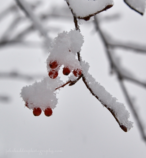
Korean Mountain ash berries in the snow
Morning Observation:
This morning in Huntington at 7:30AM it’s currently a chilly 11 degrees under overcast skies. Winds are calm. Relative humidity is 90%, dewpoint 9, barometric pressure 30.62” and steady. We have 2” of crusty snow on the ground. Yesterday’s high was 22, and the overnight low was 9.
There is a Winter Weather Advisory in effect for our region from 7:00PM tonight until 3:00PM Friday.
Forecast:
High pressure today will give way as an advancing winter storm as another November Nor’easter rolls up the coast. We’ll see widespread moderate and, at times, heavy snow across the region tonight into Friday morning, with snow totals ranging from 4″ to 9″ through midday on Friday with another round of light snow Friday night. Lingering snow is possible Saturday as well. Cool high pressure will bring quiet conditions coming out of the weekend and into the middle of next week.
We’ll see partly sunny skies today with a high near 28 and calm winds becoming southeasterly around 6 mph in the afternoon. Tonight snow is likely, mainly after 11:00pm. Snow could be heavy at times. Lows will be around 22 with southeast winds 5 to 10 mph. Chance of precipitation is 90% with snow accumulation of 3″ to 5″ possible.
Friday snow is likely before noon with a chance of rain and snow between noon and 3:00pm, then snow likely heading towards evening. Highs will be near 35 with light and variable winds becoming northerly around 5 mph. Chance of precipitation is 80% with snow accumulation of 1″ to 3″ possible. Friday night snow is likely. It’ll be mostly cloudy with a low around 30 and west winds 5 to 9 mph. Chance of precipitation is 60% with snow accumulations of less than 1/2″ possible.
Saturday’s looking mostly cloudy with a high near 37 and west winds 8 to 11 mph.
Saturday night should bring a 30% chance of snow showers after midnight. It’ll be mostly cloudy with a low around 21 and northwest winds 3 to 5 mph.
Almanac:
Last year on this date we had a high of 43 and a low of 27.
Burlington averages for this date are a low of 31 and a high of 46.
The record low was 11 in 1996.
The record high was 67 in 1956.
Sky Notes:
Sunrise: 6:47AM
Sunset: 4:24PM
Length of day: 9:37:04
Today will be 2:18 shorter than yesterday.
The Moon is in its first quarter, 7 days old with 47% illumination.
Moonrise: 1:07PM
Moonset: 11:26PM
About Today’s Photo:
The Korean mountain ash in our front yard still sports a few berries that the birds have yet to munch. The bright red contrasts nicely with the crusty snow.
Nikon D600, Nikon 14-120mm lens @ 120mm, ISO 800, f/8, 1/200″ exposure.
Wednesday, November 14, 2018

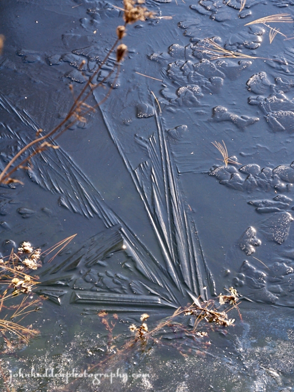
First of the season pond ice
Morning Observation:
This morning in Huntington at 7:25AM it’s currently a brisk 17 degrees under overcast skies. Winds are calm. Relative humidity is 80%, dewpoint 12, barometric pressure 30.25” and rising rapidly. We picked up an additional 0.5” of snow and 0.17” of melted precipitation, and have 1.5” of crusty snow on the ground. Yesterday’s high was 38, and the overnight low was 17.
Forecast:
High pressure will build into the region today bringing clearing skies and slowly decreasing winds. Temperatures will be on the chilly side with highs mainly in the teens to mid 20s. Tonight should be clear with light winds which, combined with some snow pack in the higher terrain, will help to produces lows ranging from near zero to the mid-teens near Lake Champlain. Thursday’s looking dry and chilly, and then another November Nor’easter is set to bring widespread plowable snow to the region Thursday night into Friday.
Morning clouds should give way to mostly sunny skies today with a high near 24 and northwest winds 13 to 15 mph gusting to 28 mph. Tonight should be mostly clear and cold with a low around 6 and northwest winds 5 to 9 mph becoming calm after midnight.
Thursday should be partly sunny with a high near 28 and calm winds becoming southerly around 6 mph in the afternoon. Thursday night snow is likely. Lows will be around 23 with southeast winds 8 to 10 mph. Chance of precipitation is 90% with snow accumulation of 1″ to 3″ possible.
Friday snow is likely before 1:00pm with rain and snow likely in the afternoon, transitioning back to snow in the evening. Highs will be near 35 with calm winds becoming westerly around 5 mph in the afternoon. Chance of precipitation is 90% with snow accumulations of 1″ to 3″ possible. Friday night should bring a 30% chance of snow. It’ll be cloudy with a low around 30 and southwest winds 3 to 5 mph.
Almanac:
Last year on this date we had a high of 35 and a low of 31.
Burlington averages for this date are a low of 32 and a high of 46.
The record low was 10 in 1996.
The record high was 67 in 1959.
Sky Notes:
Sunrise: 6:46AM
Sunset: 4:25PM
Length of day: 9:39:22
Today will be 2:20 shorter than yesterday.
The Moon is a waxing crescent, 6.2 days old with 38% illumination.
Moonrise: 12:34PM
Moonset: 10:27PM
About Today’s Photo:
With consistent cold temperatures, our pond has frozen over. Before yesterday’s snowfall, the ice set up on calm water creating wide variety of crystalline shapes and sizes. The “fan” pictured here is a good 20″ long. You can get a sense of its size by the white pine needles and asters imbedded in the ice alongside.
Panasonic GX8, Lumix 14-140mm lens @ 81mm, ISO 640, f/8, 1/160″ exposure.
Tuesday, November 13, 2018

Fresh snow falling on an oak leaf
Morning Observation:
This morning in Huntington at 7:40AM it’s currently 33 degrees and snowing under overcast skies. Winds are calm. Relative humidity is 96%, dewpoint 32, barometric pressure 30.12” and falling slowly. We’ve picked up 1” of dense snow overnight. Yesterday’s high was 43, and the overnight low was 33.
Forecast:
Low pressure moving along the East Coast will bring a mix of rain and wet snow to the region today. We’ll see snow accumulations of an inch or two in the Champlain Valley to 3″ to 6″ in the northern ‘Dacks and NEK of Vermont. A cold front will usher in blustery and colder conditions tonight into Wednesday, with highs mainly in the upper teens to upper 20s. Another coastal system will impact our region on Friday into Saturday with a mix of rain and snow likely.
Morning snow should give way to rain by midday today, then transition back to snow in the late afternoon. Highs will be near 38 with light and variable winds becoming northwesterly 5 to 10 mph in the afternoon and gusting to 20 mph. Chance of precipitation is 100% with total daytime snow accumulations of 1″ to 2″ possible. Tonight should bring a 30% chance of rain and snow showers, tapering off late. It’ll be cloudy with a low around 19 and west winds 13 to 16 mph gusting to 29 mph.
Wednesday should be mostly cloudy then gradually becoming sunny with a high near 25 and blustery northwest winds 11 to 16 mph increasing to 17 to 22 mph. Wednesday night should be mostly clear and chilly with a low around 12 and northwest winds 8 to 13 mph becoming light north after midnight.
Thursday’s looking mostly sunny and chilly with a high near 29 and calm winds becoming southerly 5 to 7 mph in the morning. Thursday night snow is likely late. Lows will be around 23 with south winds 3 to 5 mph. Chance of precipitation is 80%.
Almanac:
Last year on this date we had a high of 36 and a low of 21.
Burlington averages for this date are a low of 32 and a high of 47.
The record low was 14 in 1941.
The record high was 65 in 2012 (we had a high of 65).
Sky Notes:
Sunrise: 6:45AM
Sunset: 4:26PM
Length of day: 9:41:43
Today will be 2:23 shorter than yesterday.
The Moon is a waxing crescent, 5.4 days old with 29% illumination.
Moonrise: 11:57AM
Moonset: 9:29PM
About Today’s Photo:
Things are white this morning! The leaves of the red oak in our front yard sport a lovely mantle of fresh wet snow.
Nikon D600, Nikon 234-120mm lens @ 85mm, ISO 800, f/4, 1/25″ exposure.
Monday, November 12, 2018

Red oak leaves on the forest floor
Morning Observation:
This morning in Huntington at 7:30AM it’s currently 26 degrees under partly cloudy skies. Winds are calm. Relative humidity is 92%, dewpoint 24, barometric pressure 30.37” and steady. Yesterday’s high was 35, and the overnight low got down to 19.
There is a Winter Weather Advisory in effect for our region from 1:00AM Tuesday morning until 6:00PM Tuesday.
Forecast:
We’ve got a dry albeit seasonably chilly day on tap today as high pressure
slides off to our east. Unsettled weather will return however early Tuesday morning courtesy of a coastal low pressure system which will bring another round of widespread precipitation through Tuesday evening. Precipitation should begin as snow, then transition to mainly rain across most of Vermont during the mid-day hours, then wrap up as all snow Tuesday evening with drier conditions
developing Tuesday night. Forecasts are calling for 3″ to 6″ of snow in the ‘Dacks and NEK, with a dusting to 2″ in the Champlain Valley. A cold front will deliver a reinforcing shot of cold air behind the departing low, with temperatures well below average on Wednesday along with gusty northwesterly winds.
We’ll see mostly sunny skies today with a high near 40 and south winds around 7 mph. Tonight rain and snow are likely. Lows will be around 33 with south winds around 6 mph. Chance of precipitation is 90% with snow accumulation of less than 1/2″ possible.
Tuesday rain and snow are likely. Highs will be near 38 with southeast winds 5 to 8 mph becoming northwesterly in the afternoon. Chance of precipitation is 100% with snow accumulation of around 1″ possible. Tuesday night should bring a 30% chance of snow showers before 8:00pm. It’ll be mostly cloudy with a low around 20 and west winds 10 to 14 mph gusting to 25 mph.
Wednesday’s looking mostly sunny and chilly with a high near 26 and northwest winds 10 to 15 mph gusting to 29 mph. Wednesday night should be mostly clear with a low around 12 and northwest winds 5 to 7 mph becoming calm in the evening.
Almanac:
Last year on this date we had a high of 39 and a low of 21.
Burlington averages for this date are a low of 32 and a high of 47.
The record low was 17 in 1941.
The record high was 70 in 2012 (we had a high of 70).
Sky Notes:
Sunrise: 6:43AM
Sunset: 4:27PM
Length of day: 9:44:06
Today will be 2:25 shorter than yesterday.
The Moon is a waxing crescent, 4.5 days old with 21% illumination.
Moonrise: 11:14AM
Moonset: 8:34PM
About Today’s Photo:
With fall colors mostly gone by now, there are a few holdouts to be found. Some mature red oaks still cling to their coppery leaves on hillsides, while young oak saplings (groundlings?) often sport bright red leaves close to the ground.
Panasonic GX8, Lumix 14-140mm lens @ 30mm, ISO 800, f/8, 1/50″ exposure.
Sunday, November 11, 2018


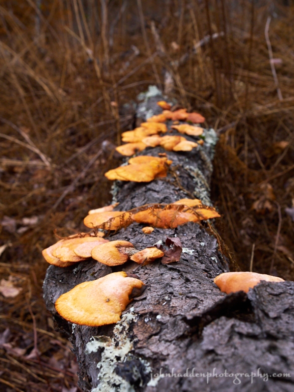
Cinnabar polypore fungus on a dead cherry tree
Morning Observation:
This morning in Huntington at 8:25AM it’s currently 27 degrees under partly cloudy skies. Winds are out of the west at 3-5 mph. Relative humidity is 67%, dewpoint 17, barometric pressure 30.27” and rising slowly. We picked up 0.12” of rain and a dusting of snow in the past 24hrs. Yesterday’s high was 40, and the overnight low was 27.
Forecast:
Surface high pressure building into the region today into Monday will deliver generally dry conditions. A coastal low pressure system will bring another
round of widespread precipitation to the region Tuesday morning and night, beginning as snow, then transitioning to mainly rain below 1000′ with a mix of rain and snow from 1000′ to 2000′, and all snow at the highest elevations. A cold front will bring a reinforcing shot of cold air behind the departing low, with temperatures well below average on Wednesday with gusty northwesterly winds.
We’ll see mostly cloudy skies today with gradual clearing. Highs will be near 31 with west winds 9 to 11 mph. Tonight should be partly cloudy with a low around 20 and west winds 5 to 7 mph becoming southerly after midnight.
Monday should be mostly cloudy with a high near 40 and south winds 5 to 7 mph. Monday night snow is likely after midnight, mixing with rain towards daybreak. I’ll be cloudy with a low around 32 and south winds 3 to 5 mph. Chance of precipitation is 70% with snow accumulation of less than one inch possible.
Tuesday rain and snow are likely before 11:00am, changing to all rain between midday. Highs will be near 38 with calm winds becoming westerly around 6 mph in the afternoon. Chance of precipitation is 100% with snow accumulation of 1″ to 3″ possible. Tuesday night snow showers are likely, possibly mixing with rain before midnight. Lows will be around 19 with west winds 5 to 11 mph. Chance of precipitation is 80%.
Almanac:
Last year on this date we had a high of 28 and a low of 16. Our pond had a layer of ice on it.
Burlington averages for this date are a low of 33 and a high of 48.
The record low was 17 in 1957.
The record high was 71 in 2002 (we had a high of 70).
Sky Notes:
Sunrise: 6:42AM
Sunset: 4:29PM
Length of day: 9:46:31
Today will be 2:27 shorter than yesterday.
The Moon is a waxing crescent, 3.6 days old with 13.8% illumination.
Moonrise: 10:25AM
Moonset: 7:42PM
About Today’s Photo:
We came across this eye-popping cinnabar polypore fungus in a logged clearing above Dugway road. The bright orange fungus was hard to miss. This particular species is found on cherry and oak. The underside of the fungus reminded us of red velvet cake.
Panasonic GX8, Lumix 14-140mm lens @ 40mm ISO 800, f/8, 1/125″ exposure.
Saturday, November 10, 2018


A late fall carpet of leaves
Morning Observation:
This morning in Huntington at 7:45AM it’s currently 40 degrees and raining lightly under overcast skies. Winds are out of the south at 3-5 mph. Relative humidity is 96%, dewpoint 39, barometric pressure 29.71” and falling slowly. We picked up 0.70” of rain in the past 24hrs. Yesterday’s high was 42, and the overnight low was 37.
Webcams from around the region are showing snow on the ground east of the Greens this morning.
Forecast:
Low pressure moving through southern Québec will bring widespread rain and snow this morning transitioning to lake effect and mountain snow showers this afternoon as a cold front sweeps through the region behind the departing low. Behind the front, strong westerly winds will develop by this afternoon with localized gusts up to 50 mph possible across the ‘Dacks and southern Vermont. Quieter weather is expected for Sunday and Monday as high pressure crests over the region. The next chance for precipitation will arrive Monday night into Tuesday as a coastal low brings a period of widespread rain and snow to the region.
Today rain showers are likely before 2:00pm tapering to a slight chance of rain and snow showers later. It’ll be cloudy with a high near 38 and southwest winds 6 to 11 mph increasing to 18 to 23 mph in the afternoon and gusting to 33 mph. Chance of precipitation is 60% with little or no snow accumulation expected. Tonight should be cloudy then gradually becoming partly cloudy with a low around 25 and west winds 16 to 25 mph.
Sunday should be sunny and chilly with a high near 32 and west winds 11 to 15 mph. Sunday night should be partly cloudy with a low around 23 and west winds 5 to 8 mph becoming calm in the evening.
Monday’s looking partly sunny with a high near 40 and calm winds becoming southerly around 6 mph in the afternoon. Monday night should bring snow mainly after 10:00pm. Lows will be around 31 with south winds 3 to 5 mph. Chance of precipitation is 80%.
Almanac:
Last year on this date we had a high of 46 and a low of 19. We picked up 0.11″ of rain and a dusting of snow with a bit of icing.
Burlington averages for this date are a low of 33 and a high of 48.
The record low was 15 in 2004 (we had a low of 11).
The record high was 74 in 1948.
Sky Notes:
Sunrise: 6:41AM
Sunset: 4:30PM
Length of day: 9:48:59
Today will be 2:29 shorter than yesterday.
The Moon is a waxing crescent, 2.6 days old with 7.6% illumination.
Moonrise: 9:29AM
Moonset: 6:55PM
About Today’s Photo:
This late fall carpet of leaves was underfoot while hiking up above Dugway Road the other day. Quite the variety of species are representing here including red oak, poplar, maple, and beech.
Panasonic GX8, Lumix 14-140mm lens @ 37mm, ISO 800, f/9, 1/100″ exposure.
Friday, November 9, 2018

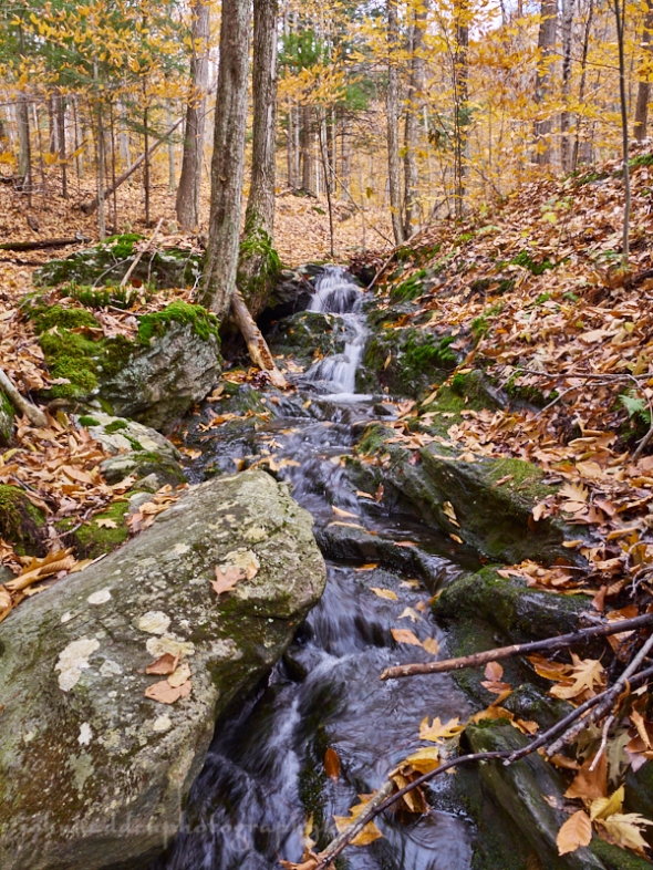
I nice little cascade in the woods north of Dugway Road
Morning Observation:
This morning in Huntington at 7:45AM it’s currently 30 degrees under mostly cloudy skies. Winds are calm. Relative humidity is 97%, dewpoint 29, barometric pressure 30.35” and falling slowly. Yesterday’s high was 46, and the overnight low was 28.
Forecast:
Low pressure heading our way from the Great Lakes will deliver some messy winter weather this afternoon with snowfall moving into northern New York and eastern Vermont during the early to mid afternoon hours. The Champlain Valley may briefly see a mix of rain and snow but will likely see just rain throughout the afternoon and evening hours. Snow amounts of 3″ to 6″ are likely across northern New York with 1″ to 3″ east of the Greens. Snowfall will taper off after midnight tonight. Gusty southwesterly winds will develop during the day Saturday on the backside of the departing low. Sunday and Monday look to be chilly but drier as high pressure builds in.
We’ll see a mix of snow and rain today kicking off this afternoon. Highs will be near 41 with light easterly winds becoming southeast 8 to 13 mph in the morning. Chance of precipitation is 80%. Tonight rain and snow are likely, tapering to drizzle late. Lows will be around 36. It’ll be breezy with a southeast winds 17 to 22 mph and gusting to 33 mph. Chance of precipitation is 100% with precipitation amounts between 1/2″ and 3/4″ possible.
Saturday rain and snow showers are likely. It’ll be mostly cloudy with a high near 37 and breezy west winds 9 to 14 mph increasing to 15 to 20 mph in the afternoon and gusting to 33 mph. Chance of precipitation is 50% with snow accumulations of less than 1/2″ possible. Saturday night should bring a 30% chance of snow showers before 8pm. It’ll be mostly cloudy with a low around 24 and west winds 13 to 15 mph gusting 29 mph.
Sunday’s looking sunny with a high near 32 and west winds 11 to 14 mph.
Sunday night should be mostly clear with a low around 21 and west winds around 5 mph becoming calm in the evening.
Almanac:
Last year on this date we had a high of 46 and a low of 22.
Burlington averages for this date are a low of 33 and a high of 48.
The record low was 12 in 1971.
The record high was 68 in 2011 (we had a high of 70).
Sky Notes:
Sunrise: 6:39AM
Sunset: 4:31PM
Length of day: 9:51:28
Today will be 2:30 shorter that yesterday.
The moon is a waxing crescent, 1.7 days old with 3% illumination.
Moonrise: 8:28AM
Moonset: 6:13PM
About Today’s Photo:
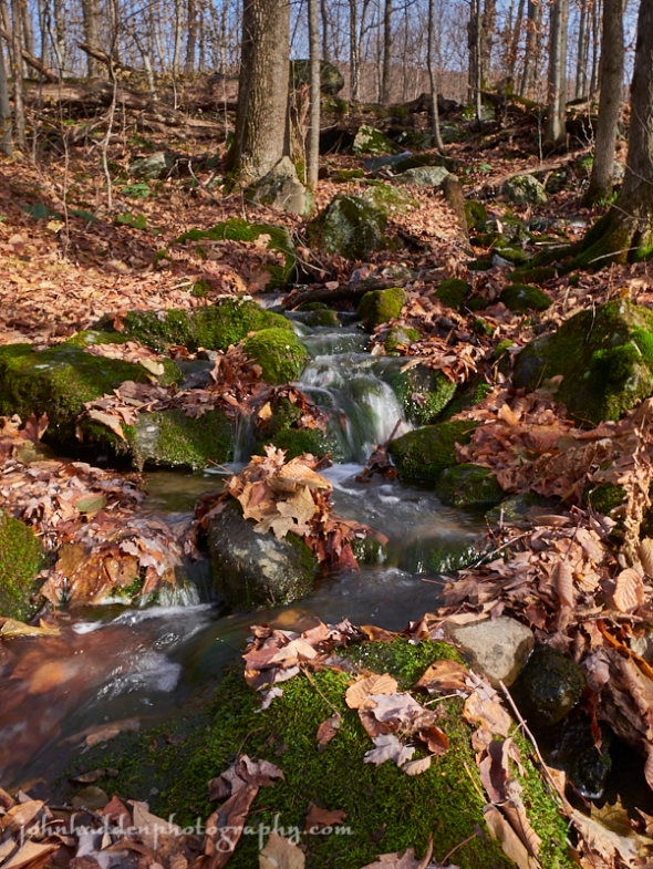
We took a little hike along the single-track trails above Dugway Road yesterday morning. This is an area I hadn’t explored before. One of the trails followed a small brook as it climbed, and there were several little cascades pouring down through the rocks. Lovely!
Panasonic GX8, Lumix 14-140mm lens @ 14mm, ISO 250, f/10, 1/10″ exposure.
Thursday, November 8, 2018


A striped maple leaf backlit by the sun
Morning Observation:
This morning in Huntington at 7:50AM it’s currently 38 degrees under mostly cloudy skies. Winds are calm. Relative humidity is 90%, dewpoint 35, barometric pressure 30.15” and rising rapidly. Yesterday’s high was 55, and the overnight low was 36.
Forecast:
We’ve got another quiet day on tap today as shortwave high pressure builds into the region. An upper level low to our west and a secondary coastal low will combine to bring widespread rain and snow to the region Friday into Saturday. Most valley locations will likely remain rain. Higher elevations above 1500′ will see snow gradually shift over to sleet and ultimately freezing rain before returning to snow late Friday night into Saturday morning. The weekend will see temperatures a bit below normal with snow showers possible in the ‘Dacks.
We’ll see partly sunny skies today with a high near 45 and west winds 9 to 11 mph. Tonight should be partly cloudy with a low around 32 and west winds 5 to 10 mph becoming light and northerly after midnight.
Friday rain is likely kicking off in the afternoon. Highs will be near 42 with light and variable winds becoming southeasterly 9 to 14 mph in the morning. Chance of precipitation is 90% with precipitation amounts between 1/10″ and 1/4″ possible. Friday night rain is likely. Lows will be around 36 with southeast winds 8 to 18 mph gusting to 30 mph. Chance of precipitation is 100% with precipitation amounts between 1/2″ and 3/4″ possible.
Saturday rain and snow showers are likely in the morning, tapering to a chance of rain showers in the afternoon. It’ll be mostly cloudy with a high near 40 and southwest winds 9 to 18 mph gusting to 30 mph. Chance of precipitation is 60%.
Saturday night should bring a 30% chance of snow showers before 7pm. It’ll be mostly cloudy with a low around 25 and west winds 9 to 13 mph gusting to 29 mph.
Almanac:
Last year on this date we had a high of 44 and a low of 19.
Burlington averages for this date are a low of 33 and a high of 49.
The record low was 17 in 2003 (we had a low of 11).
The record high was 74 in 1996.
Sky Notes:
Sunrise: 6:38AM
Sunset: 4:32PM
Length of day: 9:53:59
Today will be 2:32 shorter than yesterday.
The Moon is a waxing crescent, 0.07 days old with 0.5% illumination.
Moonrise: 7:23AM
Moonset: 5:35PM
About Today’s Photo:
This striped maple leaf (A.K.A. moosewood) caught my eye while walking the Camel’s Hump Nordic trails the other day. Its leathery, veined texture is interesting.
Panasonic GM5, Lumix 12-32mm lens @ 32mm, ISO 800, f/5.6, 1/1600″ exposure.
Wednesday, November 7, 2018

Looking west from Stagecoach Road
Morning Observation:
This morning in Huntington at 6:50AM it’s currently 49 degrees under mostly cloudy skies. A few random drops of rain are falling. Winds are out of the southwest at 4-6 mph. Relative humidity is 74%, dewpoint 41, barometric pressure 29.76” and rising rapidly. We picked up 0.46” of rain in the past 24hrs. Yesterday’s high was 54, and the overnight low was 49.
Forecast:
We’ve got another day of gusty winds and mild temperatures on tap across the region today. Winds will diminish heading into the evening with calmer weather expected on Thursday. A low pressure system will approach from the Ohio River valley on Friday bringing widespread rainfall in the valleys and a mix of rain, sleet, freezing rain, and snow to elevations above 2500 ‘. Precipitation will wind down heading into Saturday but continued showers are possible throughout the weekend along with gradually cooling temperatures.
Today will bring a 20% chance of showers. It’ll be partly sunny with a high near 52 and gusting southwest winds 14 to 20 mph. Tonight should bring a 20% chance of showers. It’ll be mostly cloudy with a low around 37 and southwest winds 10 to 13 mph.
Thursday should be partly sunny with a high near 44 and west winds 10 to 14 mph.
Thursday night should be mostly cloudy with a low around 32 and west winds 5 to 8 mph becoming northerly after midnight.
Friday rain is likely. Highs will be near 41 with light and variable winds becoming southeasterly 5 to 10 mph in the morning. Chance of precipitation is 100% with precipitation amounts between 1/10″ and 1/4″ possible. Friday night rain is likely. Lows will be around 36 with southeast winds 8 to 11 mph gusting to 29 mph. Chance of precipitation is 100% with precipitation amounts between 1/2″ and 3/4″ possible. Elevations over 2000′ should see accumulating snow along with some icing possible.
Almanac:
Last year on this date we had a high of 37 and a low of 23. We picked up 0.16″ of rain.
Burlington averages for this date are a low of 34 and a high of 49.
The record low was 14 in 1962.
The record high was 68 in 1975.
Sky Notes:
Sunrise: 6:37AM
Sunset: 4:33PM
Length of day: 9:56:31
Today will be 2:34 shorter than yesterday.
The Moon is new, 29 days old with 0.2% illumination.
Moonrise: 6:16AM
Moonset: 5:01PM
About Today’s Photo:
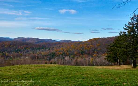
The view west from Stagecoach Road off Bert White Road on Sunday was lovely. The tawny leaves of oaks can still be seen on the hillside above East Street, and peaks of the ‘Dacks are peeking above the horizon.
Panasonic GM5, Lumix 12-32mm lens @ 21mm, ISO 800, f/13, 1/640″ exposure.
Tuesday, November 6, 2018

Water babbles over moss covered rocks up at Camel’s Hump Nordic
Please get out and VOTE today!
Morning Observation:
This morning in Huntington at 7:05AM it’s currently a balmy 49 degrees under mostly cloudy skies. Winds are out of the south at 3-5 mph. Relative humidity is 84%, dewpoint 44, barometric pressure 29.96” and falling rapidly. We picked up 0.04” of rain in the past 24hrs. Yesterday’s high was 45, and the overnight low was 43.
Forecast:
After a break in rain showers this morning, rainfall will return to the region as an occluded front tracks toward the region. Gusty winds will develop during the afternoon with winds gusting in the 15 to 30 mph range. Rainfall will taper off this evening as moisture shifts eastward. The middle of the week looks to be mostly dry with seasonable temperatures, but a series of troughs and cold fronts pushing through the region will continue the pattern of unsettled conditions with the potential for some light showers Wednesday. More rain will arrive Friday into Saturday.
Today showers are likely. High will be near 53 with southeast winds 9 to 16 mph gusting to 32 mph. Chance of precipitation is 80% with precipitation amounts between 1/10′ to 1/4″ possible. Tonight should bring a 30% chance of showers. It’ll be mostly cloudy with a low around 47 and southwest winds 15 to 17 mph gusting to 30 mph.
Wednesday should bring a 20% chance of showers between midday. It’ll be partly sunny with a high near 52 and southwest winds 14 to 16 mph. Wednesday night should be mostly cloudy with a low around 39 and southwest winds around 10 mph and gusting to 20 mph.
Thursday’s looking mostly cloudy with a high near 45 and west winds 9 to 13 mph.
Thursday night should mostly cloudy with a low around 32 and west winds around 5 mph becoming calm in the evening.
Almanac:
Last year on this date we had a high of 53 and a low of 36. We picked up 0.13″ of rain.
Burlington averages for this date are a low of 34 and a high of 49.
The record low was 13 in 1951.
The record high was 75 in 1948.
Sky Notes:
Sunrise: 6:35AM
Sunset: 4:34PM
Length of day: 9:59:06
Today will be 2:36 shorter than yesterday.
The Moon is a waning crescent, 28 days old with 2% illumination.
Moonrise: 5:05AM
Moonset: 4:40PM
About Today’s Photo:
The recent frequent rains have done a lot to recharge the water table after the moderate drought conditions we “enjoyed” this past summer. It’s nice to see (and hear!) the intermittent streams running again in the upcountry.
Panasonic GM5, Lumix 12-32mm lens @ 14mm, ISO 200, f/20, 1/8″ exposure.
Monday, November 5, 2018


Snow capped club mosses at 2300′
Morning Observation:
This morning in Huntington at 7:00AM it’s currently 38 degrees under partly cloudy skies. Winds are out of the south at 3-5 mph. Relative humidity is 77%, dewpoint 31, barometric pressure 30.46” and falling slowly. Yesterday’s high was 41, and the overnight low was 27.
Forecast:
A warm front will lift through the region today and tonight as high pressure moves off to the northeast. The front will bring warmer air north along with increased clouds and chances for showers on Monday into early Tuesday. Another system will bring more widespread rain Tuesday and Tuesday evening. Precipitation should wind down Wednesday through the rest of the week.
We’ll see a 40% chance of showers this afternoon. It’ll become cloudy with a high near 44 and southeast wind 13 to 15 mph gusting 28 mph. Tonight showers are likely. It’ll be cloudy with a low around 40 and south winds 7 to 10 mph gusting to 20 mph. Chance of precipitation is 70%.
Tuesday showers are likely. Highs will be around 53 with southeast winds 8 to 15 mph. Chance of precipitation is 90% with rainfall amounts of 1/2″ to 3/4″ possible. Tuesday night showers are likely. It’ll be cloudy with a low around 43 and southwest winds 15 to 17 mph gusting 28 mph. Chance of precipitation is 70% with precipitation amounts between 1/0″ and 1/4″ possible.
Wednesday’s looking mostly cloudy with a high near 49 and southwest winds 15 to 17 mph gusting to 33 mph. Wednesday night should be mostly cloudy with a low around 36 and west wind around 11 mph.
Almanac:
Last year on this date we had a high of 59 and a low of 34. We picked up 0.01″ of rain.
Burlington averages for this date are a low of 34 and a high of 50.
The record low was 18 in 1965.
The record high was 70 in 2015 (we had a high of 72).
Sky Notes:
Sunrise: 6:34AM
Sunset: 4:36PM
Length of day: 10:01:42
Today will be 2:37 shorter than yesterday.
The Moon is a waining crescent, 27 days old with 6% illumination.
Moonrise: 3:56AM
Moonset: 4:01PM
About Today’s Photo:
I was up helping to clear trails at Camel’s Hump Nordic yesterday morning. We climbed to the saddle between Bald Hill and Crow Hill at 2300′. There was a good 1.5″ of snow on the ground up there. The carpets of club mosses sported a lovely layer with little hats on top!
Panasonic GM5, Lumix 12-32mm lens @ 32mm, ISO 800, f/8, 1/5000″ exposure.
Sunday, November 4, 2018

Wild grapes along East Street
Morning Observation:
This morning in Huntington at 7:05AM Eastern Standard Time, it’s currently 35 degrees under mostly cloudy skies. Winds are out of the south at 0-4 mph. Relative humidity is 79%, dewpoint 29, barometric pressure 30.46” and rising rapidly. We picked up 0.98” of rain in the past 24hrs. Yesterday’s high was 48, and the overnight low was 35.
Forecast:
We’ve got a dry and partly sunny day on tap today courtesy of high pressure currently building into the region. A warming trend will begin Monday out ahead of a pair of low pressure systems that will bring periods of rain towards the middle and end of the week.
We’ll see sunny skies today with a high near 40 and west winds 5 to 8 mph becoming light and variable in the afternoon. Tonight should be partly cloudy with a low around 30 and southeast winds 3 to 8 mph.
Monday should bring a 50% chance of showers in the afternoon. It’ll be partly sunny with a high near 45 and southeast winds 10 to 13 mph. Monday night showers are likely. It’ll be cloudy with a low around 39 and southeast winds 6 to 11 mph. Chance of precipitation is 70%.
Tuesday showers are likely. Highs will be near 54 with southeast winds 6 to 15 mph gusting to 33 mph. Chance of precipitation is 80% with precipitation amounts between 1/4″ to 1/2″ possible. Tuesday night showers are likely. It’ll be mostly cloudy with a low around 45 and southwest winds 13 to 16 mph gusting to 30 mph. Chance of precipitation is 70% with precipitation amounts between 1/10″ 1/4″ possible.
Almanac:
Last year on this date we had a high of 45 and a low of 34. We picked up 0.26″ of rain.
Burlington averages for this date are a low of 34 and a high of 50.
The record low was 20 in 2013 (we had a low of 15).
The record high was 73 in 1982.
Sky Notes:
Sunrise: 6:33AM EST
Sunset: 4:37PM EST
Length of day: 10:04:20
Today will be 2:39 shorter than yesterday.
The Moon is a waning crescent, 26 days old with 13% illumination.
Moonrise: 2:45AM
Moonset: 3:33PM
About Today’s Photo:
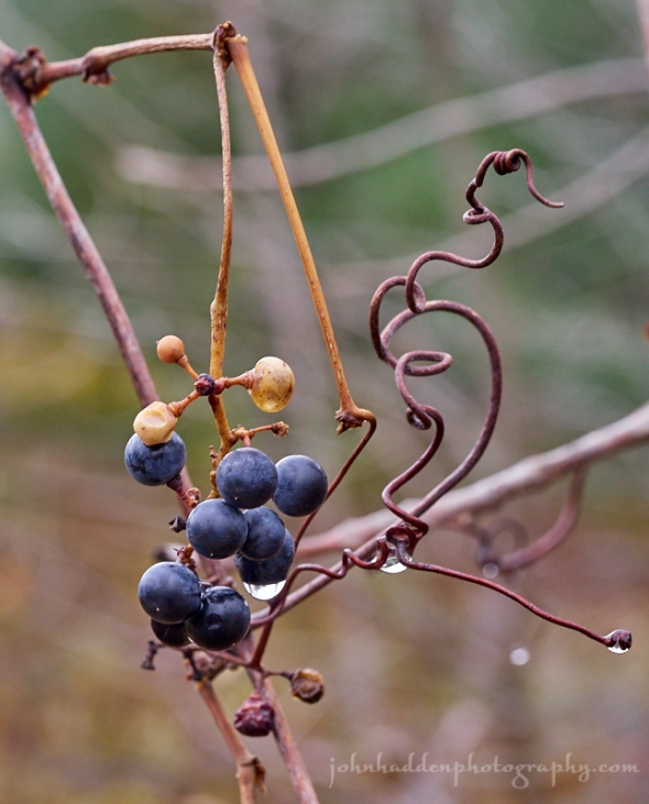
This bunch of rain soaked wild grapes caught my eye at the top of our driveway the other day. There’s something sculptural about the arrangement that I like.
Panasonic GX8, Olympus 60mm macro lens, ISO 800, f/7.1m 1/80″ exposure.
Saturday, November 3, 2018

Brilliant yellow tamarack in our front field
Morning Observation:
This morning in Huntington at 6:25AM it’s currently 44 degrees under overcast skies. Winds are calm. Relative humidity is 98%, dewpoint 44, barometric pressure 29.59” and steady. We picked up 0.65” of rain in the past 24hrs. Yesterday’s high was 55, and the overnight low was 44.
Forecast:
Deepening low pressure will move through New England today and into eastern Canada tonight bringing periods of rain and strong westerly winds. Brief high pressure will build into the region Sunday bringing quieter weather into early Monday. Another low pressure system lifting through the Great Lakes Monday will bring the next chance of rainfall by the Monday night into middle of next week along with gusty south winds.
Today rain is likely. Highs will be near 46 with north winds 5 to 15 mph becoming westerly in the afternoon and gusting to 26 mph. Chance of precipitation is 100% with rainfall amounts between 1/4″ to 1/2″ possible. Tonight rain is likely, possibly mixed with snow showers in the mountains. It’ll be cloudy with a low around 30 and west winds 15 to 20 mph gusting to 34 mph. Chance of precipitation is 60%.
Sunday should be sunny with a high near 42 and west winds 5 to 10 mph becoming light and northerly in the afternoon. Sunday night should be partly cloudy with a low around 31 and southeast winds 3 to 8 mph.
Monday should bring a 40% chance of showers in the afternoon. It’ll be increasingly cloudy with a high near 45 and south winds 11 to 15 mph. Monday night showers are likely. It’ll be cloudy with a low around 40 and southeast winds 6 to 8 mph. Chance of precipitation is 60%.
Almanac:
Last year on this date we had a high of 66 and a low of 35. We picked up 0.32″ of rain.
Burlington averages for this date are a low of 34 and a high of 51.
The record low was 15 in 2002 (we had a low of 9!)
The record high was 74 in 1982.
Sky Notes:
Sunrise: 7:31AM
Sunset: 5:38PM
Length of day: 10:06:59
Today will be 2:40 shorter than yesterday.
Daylight Saving Time ends tonight at 2:00AM so remember to set your clocks back an hour.
The Moon is a waning crescent, 25 days old with 22.5% illumination.
Moonrise: 2:33AM
Moonset: 4:03PM
About Today’s Photo:
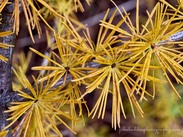
The two tamarack (A.K.A. larch) that we planted in our front field several years ago have turned brilliantly yellow. Tamaracks are one of the only conifer trees that are deciduous, dropping their “leaves” each fall. The bright yellow of the needles is a fall bonus!
Panasonic GX8, Olympus 60mm macro lens, ISO 800, f/8, 1/80″ exposure.
Thursday, November 1, 2018

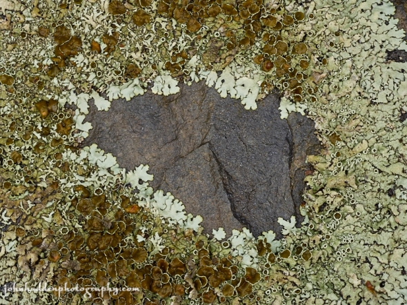
A ring of lichens on the rock wall of our back patio
Rabbit-rabbit!
Morning Observation:
This morning in Huntington at 7:30AM it’s currently a balmy 42 degrees under mostly cloudy skies. Winds are calm. Relative humidity is 96%, dewpoint 41, barometric pressure 29.90” and steady. We picked up 0.10” of rain in the past 24hrs. Yesterday’s high was 54, and the overnight low was 42.
Forecast:
We’ve got an active weather pattern on tap going into the weekend with several waves of moderate rain expected over the region. A stalled frontal boundary stretching from the Mississippi River valley northeastward into New England will allow for several low pressure systems to move across the region. The first wave of rain will move through this afternoon and evening, and the second wave will be on Saturday morning. We can expect a brief period of pleasant weather on Sunday and Monday as high pressure builds in before the next round of unsettled weather returns by mid week.
We’ll see rain today, mainly this afternoon. It’ll be cloudy with a high near 46 and light north winds. Chance of precipitation is 70%. Tonight rain is likely. Lows will be around 40 with calm winds becoming easterly around 5 mph after midnight. Chance of precipitation is 100%. We may see up to 3/4″ overnight.
Friday rain is likely. It’ll be cloudy with a high near 52 and calm winds. Chance of precipitation is 70% with precipitation amounts between 1/4″ and 1/2″ possible. Friday night rain is likely. Lows will be around 42 with north winds around 5 mph becoming calm in the evening. Chance of precipitation is 80% with precipitation amounts between 1/4″ and 1/2″ possible.
Saturday rain is likely. Highs will be near 47 with northwest winds 5 to 8 mph. Chance of precipitation is 90% with precipitation amounts between 1/10″ and 1/4″ possible. Saturday night should bring a 30% chance of showers. It’ll be cloudy with gradual clearing. Lows will be around 32 with west winds around 10 mph.
Almanac:
Last year on this date we had a high of 48 and a low of 33. We picked up 0.10″ of rain.
Burlington averages for this date are a low of 35 and a high of 51.
The record low was 19 in 1951.
The record high was 71 in 2013 (we had a high of 66).
Average rainfall for this date is 0.12″
Sky Notes:
Sunrise: 7:29AM
Sunset: 5:41PM
Length of day: 10:12:22
Today will be 2:43 shorter than yesterday.
The Moon is a waning crescent, 22.8 days old with 43% illumination.
Moonrise: 12:10AM
Moonset: 2:56PM
About Today’s Photo:
The rocks comprising our back patio wall have had plenty of time to form lovely layers of lichens. These ancient life forms are composed of algae and fungi in a symbiotic relationship. The algae allows for photosynthesis while the fungi works to break down nutrients from the rock on which it sits.
Panasonic GX8, Olympus 60mm macro lens, ISO 649, f/8, 1/160″ exposure.
