Saturday, September 30, 2023

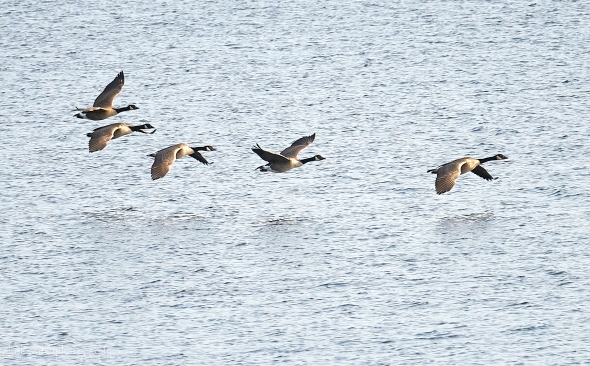 Canada geese over the water
Morning Observation:
This morning in North Hero at 7:10AM it’s currently 58 degrees under mostly cloudy skies. Winds are calm. Relative humidity is 92%, dewpoint 56, barometric pressure 30.22”. Yesterday’s high was 66, and yesterday’s low was 59. The overnight low got down to 57.
This morning in Huntington it’s currently 48 degrees under mostly cloudy skies. Winds are calm. Relative humidity is 97%, dewpoint 47, barometric pressure 30.24”. Yesterday’s high was 65, and yesterday’s low was 44. The overnight low got down to 47.
Forecast Discussion:
We’re all set for a continued prolonged stretch of dry and seasonable days ahead courtesy of high pressure over the eastern US. Temperatures are expected to be above seasonal norms by midweek next week with highs in the upper 70s to low 80s Tuesday and mid 80s by Wednesday. The next chance of showers looks to be maybe Friday into Saturday, but even that is looking iffy at this point…
3-Day Forecast:
We’ll see clearing skies today with a high near 73 and calm winds becoming northerly around 5 mph in the afternoon. Tonight should be mostly clear with a low around 51 and calm winds.
Sunday should be mostly sunny with a high near 75 with calm winds becoming northwesterly 5-7 mph in the afternoon. Sunday night should be partly cloudy with a low around 52 and north winds around 5 mph becoming calm in the evening.
Monday should be sunny with a high near 75 and light and variable winds. Monday night should be mostly clear with a low around 53 and calm winds becoming southerly 5-10 mph after midnight.
Almanac:
Last year on this date in Huntington we had a high of 64 and a low of 31. We had our first light frost.
Last year in North Hero we had a high of 60 and a low of 45.
Burlington averages for this date are a low of 47 and a high of 66.
The record low was 26 in 1941.
The record high was 81 in 1948.
The Lake Champlain lake level in Burlington is 96.58′.
The water temperature is 66˚.
Last year’s lake level was at 94.84′.
Sky Notes:
Sunrise: 6:48AM
Sunset: 6:34PM
Length of day: 11:46:35
Today will be 3:02 shorter than yesterday.
The Moon is waning gibbous, 15.7 days old with 98% illumination.
Moonrise: 7:17PM
Moonset: 8:11AM
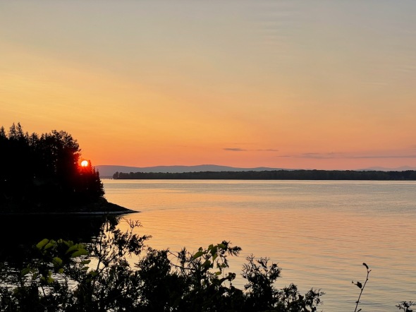
About Today’s Photo:
One of the many pleasures of living on the lake is watching the Canada geese throughout the summer season. We watch individual family units nesting nearby in the spring, the daily “goose commute” between Hen Island and North Hero Village during midsummer, flight training in late summer, and now the gathering of the flocks in preparation for migration. Soon they’ll be on their way south!
Sony A7II, Sigma 100-400mm lens @ 400mm, ISO 1250, f/6.5, 1/1200″ exposure
Friday, September 29, 2023

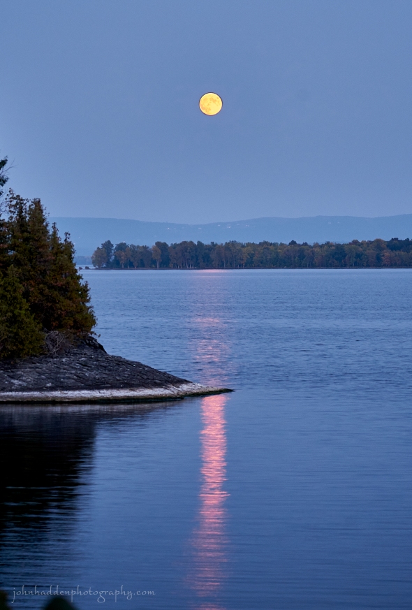 Last evening’s moonrise. Read below for some interesting info about tonight’s Harvest Moon…
Morning Observation:
This morning in North Hero at 7:25AM it’s currently 59 degrees under mostly cloudy skies. Winds are out of the south at 4-6 mph. Relative humidity is 82%, dewpoint 54, barometric pressure 30.23”. Yesterday’s high was 69, and yesterday’s low was 53. The overnight low got down to 59.
This morning in Huntington it’s currently 46 degrees under cloudy skies. Winds are calm. Relative humidity is 97%, dewpoint 45, barometric pressure 30.28”. Yesterday’s high was 74, and yesterday’s low was 41. The overnight low got down to 44.
Forecast Discussion:
Deep low pressure passing through southern New England will bring clouds to most of the north country today with a chance of some light showers to far southern Vermont today. After today, we’ll continue to be under the influence of deep high pressure over the northeast which will continue our stretch of dry and seasonable weather clear through most of next week. We may even see some record highs by the middle of next week as temperatures push the upper 70s to near 80 on Tuesday and Wednesday. The next chance of rain looks to be next Friday sometime.
3-Day Forecast:
We’ll see mostly cloudy skies today with a high near 70 with south winds 6-8 mph. Tonight should be mostly cloudy with a low around 50 and south winds 3-8 mph.
Saturday should be mostly sunny with a high near 73 and light and variable winds becoming northerly around 5 mph in the afternoon. Saturday night should be mostly clear with a low around 49 in Huntington and 57 in North Hero with light and variable winds.
Sunday should be sunny with a high near 76 with calm winds becoming northwesterly 5-7 mph in the afternoon. Sunday night should be partly cloudy with a low around 55 with north winds 3-5 mph.
Almanac:
Last year on this date in Huntington we had a high of 55 and a low of 34.
Last year in North Hero we had a high of 57 and a low of 46.
Burlington averages for this date are a low of 67 and a low of 48.
The record low was 28 in 2000 (We had a low of 25 in Huntington).
The record high was 82 in 1948.
The Lake Champlain lake level in Burlington is 96.65′.
The water temperature is 66˚.
Last year’s lake level was at 94.82′.
Sky Notes:
Sunrise: 6:47AM
Sunset: 6:36PM
Length of day: 11:49:37
Today will be 3:02 shorter than yesterday.
The Moon is the full “Harvest” moon, 14.6 days old with 100% illumination.
Moonrise: 6:55PM
Moonset: 6:50AM
You may have noticed that the timing of moonrises over the past several weeks has gotten closer and closer. In June, for example, the moon rises about 50 minutes later each day, but tonight the moon will rise only about 21 minutes later than last night. I was curious about this so I did a bit of digging. Turns out that this phenomenon occurs around each fall equinox due to the angle of the moon relative to the axial tilt of the earth. For a good explanation of this read here. I also learned that the main reason this moon is called the Harvest moon is that, since it rises close to the sunset every evening near its full phase, the moon provided extra light to farmers bringing in their fall crops! Pretty cool!
About Today’s Photo:
Yesterday’s near full moon lights up the water by our neighbor’s point.
Sony A7II, Sigma 100-400mm lens @ 100mm, ISO 1250, f/5, 1/4″ exposure
Thursday, September 28, 2023

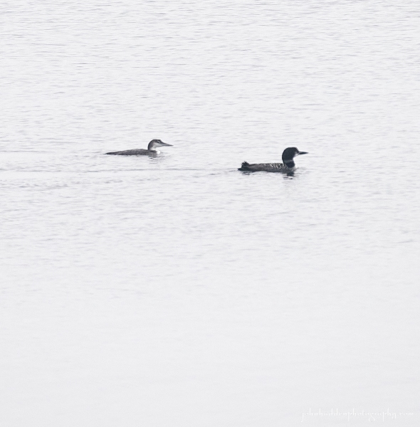 A juvenile and adult loon off our point
Morning Observation:
This morning in North Hero at 7:20AM it’s currently 54 degrees under dense fog (visibility about 75 yards…) Winds are light out of the south. Relative humidity is 96%, dewpoint 53 barometric pressure 30.30”. Yesterday’s high was 66, and yesterday’s low was 48. The overnight low got down to 53.
This morning in Huntington it’s currently 41 degrees under mostly clear skies. Winds are calm. Relative humidity is 97%, dewpoint 40, barometric pressure 30.35”. Yesterday’s high was 70, and yesterday’s low was 37. The overnight low got down to 41.
Forecast Discussion:
High pressure? Check. Dry and seasonable conditions? Check. Rinse and repeat clear through next week? Roger-that. A low pressure system will is expected to swing through southern New England Friday into Saturday bringing some clouds and a very slight chance of some showers to far southern Vermont late Friday into early Saturday. Otherwise we’ve got clear sailing with seasonably warm temperatures clear through next week. The long range crystal ball shows our next chance of any rain arriving the weekend of October 7.
3-Day Forecast:
We’ll see mostly sunny skies today with a high near 72 and light southeast winds. Tonight should be partly cloudy with a low around 50 and south winds 5-8 mph.
Friday should bring increasing clouds with a high near 70 with south winds around 7 mph. Friday night should be mostly cloudy with a low around 51 and light south winds.
Saturday should be sunny with a high near 74 and light and variable winds. Saturday night should be mostly clear with a low around 53 and calm winds.
Almanac:
Last year on this date in Huntington we had a high of 60 and a low of 51. We picked up 0.16″ of rain.
Last year in North Hero we had a high of 66 and a low of 54. We picked up 0.09″ of rain.
Burlington averages for this date are a low of 48 and high of 67.
The record low was 26 in 1947.
The record high was 83 in 2014 (we had a high of 80 in Huntington).
The Lake Champlain lake level in Burlington is 96.73′.
The water temperature is 66˚.
Last year’s lake level was at 94.80′.
Sky Notes:
Sunrise: 6:45AM
Sunset: 6:38PM
Length of day: 11:52:39
Today will be 3:02 shorter than yesterday.
The Moon is waxing gibbous, 13.5 days old with 98% illumination.
Moonrise: 6:32PM
Moonset: 5:27AM
About Today’s Photo:
We’ve been seeing quite a few loons recently as they begin their travels southward and towards coastal waters for the winter. Lake Champlain’s highly variable water levels make it difficult for loons to nest as they need to build their nests right at the water line for easy water access. Consequently, we don’t see them much during the summer. This juvenile and its accompanying adult were fishing in our cove.
Sony A7II, Sony 24-240mm lens @ 400mm, ISO 1250, f/8, 1/1000″ exposure
Wednesday, September 27, 2023

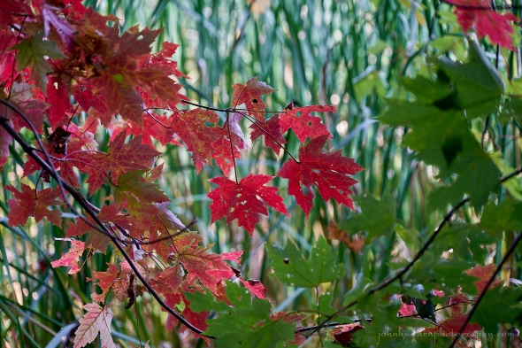 Silver maples reddening in Pelots Bay
Morning Observation:
This morning in Huntington at 6:55AM it’s currently a cool 47 degrees under mostly clear skies. Winds are calm. Relative humidity is 96%, dewpoint 96, barometric pressure 30.42”. Yesterday’s high was 68, and yesterday’s low was 40. The overnight low got down to 37.
This morning in North Hero it’s currently 49 degrees under partly cloudy skies. Winds are calm. Relative humidity is 94%, dewpoint 47, barometric pressure 40.40”. Yesterday’s high was 69, and yesterday’s low was 52. The overnight low got down to 49.
Forecast Discussion:
High pressure centered over eastern Canada will continue our stretch of lovely fall weather through the upcoming weekend and into the middle of next week. Highs today will be similar to yesterday’s—in the mid to upper 60s—with lows tonight dipping into the upper 30s in colder spots and around 50 near Lake Champlain. A bit of a warming trend is expected heading into the weekend with highs pushing into the mid 70s. It’s gunna be lovely!
3-Day Forecast:
We’ll see mostly sunny skies today with a high near 70 and light north winds. Tonight should be mostly clear with a low around 43 in Huntington and 52 in North Hero with light north winds.
Thursday should be sunny with a high near 73 and light and variable winds. Thursday night should be mostly clear with a low around 49 and southeast winds 5-10 mph.
Friday should be partly sunny with a high near 71 and south winds 5-10 mph. Friday night should be mostly clear with a low around 48 and light south winds.
Almanac:
Last year on this date in Huntington we had a high of 59 and a low of 45. We picked up 0.02″ of rain.
Last year in North Hero we had a high of 61 and a low of 57. We picked up 0.05″ of rain.
Burlington averages for this date are a low of 49 and a high of 68.
The record low was 27 in 1947.
The record high was 90 in 2017 (we had a high of 88 in Huntington).
The Lake Champlain lake level in Burlington is 96.81′.
The water temperature is 66˚.
Last year’s lake level was at 94.74′.
Sky Notes:
Sunrise: 6:44AM
Sunset: 6:40PM
Length of day: 11:55:41
Today will be 3:02 shorter than yesterday.
The Moon is waxing gibbous, 12 days old with 93% illumination.
Moonrise: 6:10PM
Moonset: 4:05AM
About Today’s Photo:
Silver maples in nearby swamps along Lake Champlain have been showing their fall color for a couple of weeks now. It’s interesting to see distinct patches of red along the shoreline indicating a wetland or swamp nestled in between the still-green foliage of other species.
Sony A7II, Sony 24-240mm lens @ 191mm, ISO 1250, f/6.2, 1/100″ exposure
Tuesday, September 26, 2023

 The sun rises over our neighbor’s point
Morning Observation:
This morning in North Hero at 7:05AM it’s currently 52 degrees under partly cloudy skies. Winds are light out of the northwest. Relative humidity is 92%, dewpoint 50, barometric pressure 30.41”. Yesterday’s high was 74, and yesterday’s low was 53. The overnight low got down to 52.
This morning in Huntington it’s currently 40 degrees under partly cloudy skies. Winds are calm. Relative humidity is 96%, dewpoint 39, barometric pressure 40.43”. Yesterday’s high was 71, and yesterday’s low was 42. The overnight low got down to 40.
Forecast Discussion:
I think I’ll write this now and just repeat it for the next week or so… A broad area of high pressure will set up over the northeastern US and eastern Canada and rule our weather for the next week. We’ll see seasonably dry, sunny days and cool nights with morning valley fog. Some frost may occur by tomorrow morning in the usual cold spots in the ‘Dacks and NEK. Pretty much perfect conditions to kick off the fall!
3-Day Forecast:
We’ll see sunny skies today with a high near 67 and northeast winds 5-9 mph. Tonight should be mostly clear with a low around 41 in Huntington and 47 in North Hero with light north winds.
Wednesday should be sunny with a high near 69 and calm winds becoming easterly around 5 mph in the afternoon. Wednesday night should be partly cloudy with a low around 43 in Huntington and 51 in North Hero with light north winds.
Thursday should be sunny with a high near 72 and light southeast winds. Thursday night should be partly cloudy with a low around 46 in Huntington and 54 in North Hero with south winds 3-5 mph.
Almanac:
Last year on this date in Huntington we had a high of 67 and a low of 48. We picked up 0.06″ of rain.
Last year in North Hero we had a high of 66 and a low of 55. We picked up 0.10″ of rain.
Burlington averages for this date are a low of 49 and a high of 68.
The record low was 27 in 1947.
The record high was 91 in 2017 (we had a high of 90 in Huntington).
The Lake Champlain lake level in Burlington is 96.91′.
The water temperature is 66˚.
Last year’s lake level was at 94.81′.
Sky Notes:
Sunrise: 6:43AM
Sunset: 6:42PM
Length of day: 11:58:43
Today will be 3:02 shorter than yesterday.
The Moon is waxing gibbous, 11 days old with 86% illumination.
Moonrise: 5:47PM
Moonset: 2:41AM
About Today’s Photo:
This date is kind of an astronomical marker for us here on the point as the sun finally makes its way far enough southward to clear our neighbor’s point so that we can actually see it rise above the spine of the Greens. Happy Point Day!
iPhone 12 Pro
Monday, September 25, 2023

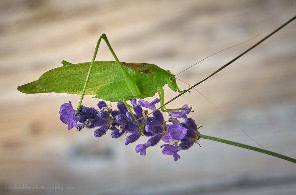 A katydid on lavender
Morning Observation:
This morning in North Hero at 7:35AM it’s currently 55 degrees under partly cloudy skies. Winds are light out of the west. Relative humidity is 88%, dewpoint 51, barometric pressure 30.15”. Yesterday’s high was 70, and yesterday’s low was 58. The overnight low got down to 53.
This morning in Huntington it’s currently 43 degrees under partly cloudy skies. Winds are calm. Relative humidity is 97%, dewpoint 42, barometric pressure 30.16”. Yesterday’s high was 68, and yesterday’s low was 45. The overnight low got down to 42.
Forecast Discussion:
The remnants of tropical storm Ophelia are still lingering over southern New England this morning and will bring clouds to southern portion of Vermont this morning. High pressure building into the region will bring clearing skies to the north with a bit of good ol’ Canadian wildfires mixing in a bit in the upper atmosphere. High pressure looks set to dominate our weather bringing dry and seasonable conditions through next weekend and even possibly into early next week. Daytime highs will be in the upper 60s to low 70s each day with chilly nights. Tuesday night is looking to be the chilliest of the period as clear skies and light winds may allow for some frost formation in the usual cold pockets by Wednesday morning.
3-Day Forecast:
We’ll see mostly sunny skies today with a high near 70 and north winds 5-12 mph. Tonight should be mostly clear with a low around 46 in Huntington and 53 in North Hero with northeast winds 6-12 mph.
Tuesday should be sunny with a high near 65 and northeast winds around 8 mph. Tuesday night should be mostly clear with a low around 45 light northeast wind.
Wednesday should be sunny with a high near 71 with light night winds. Wednesday night should be partly cloudy with a low around 45 in Huntington and 52 in North Hero with calm winds.
Almanac:
Last year on this date in Huntington we had a high of 59 and a low of 41. We picked up 0.32″ of rain.
Last year in North Hero we had a high of 59 and a low of 54. We picked up 0.16″ of rain.
Burlington averages for this date are a low of 49 and a high of 69.
The record low was 28 in 1963.
The record high was 92 in 2017 (we had a high of 91 in Huntington).
The Lake Champlain lake level in Burlington is 96.94′.
The water temperature is 66˚.
Last year’s lake level was at 94.76′.
Sky Notes:
Sunrise: 6:42AM
Sunset: 6:44PM
Length of day: 12:01:45
Today will be 3:02 shorter than yesterday.
The Moon is waxing gibbous, 10 days old with 77% illumination.
Moonrise: 5:18PM
Moonset: 1:18AM
About Today’s Photo:
Robin was harvesting our basil crop the other day and this katydid leapt out onto one of the yellow butterfly chairs on our camp deck. I figured I’d put it in a more conducive place for both the bug and for the photographer, so a nearby bit of lavender looked like a good spot. So, yah, guilty of a bit of staging for this shot… You’ll usually find these critters in the green, grassy fields where their coloration helps to camouflage them quite well.
Sony A7II, Sony 90mm macro lens, ISO 1250, f/13, 1/200″ exposure
Sunday, September 24, 2023

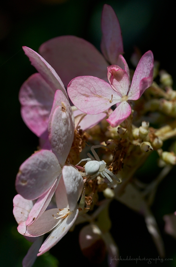 A crab spider lurks in a blushing hydrangea
Morning Observation:
This morning in North Hero at 7:25AM it’s currently 59 degrees under low overcast/foggy skies. Winds are calm. Relative humidity is 96%, dewpoint 58, barometric pressure 30.17”. Yesterday’s high was 71, and yesterday’s low was 60. The overnight low got down to 58.
This morning in Huntington it’s currently 52 degrees under overcast skies. Winds are calm. Relative humidity is 97%, dewpoint 51, barometric pressure 30.20”. Yesterday’s high was 69, and yesterday’s low was 44. The overnight low got down to 52.
Forecast Discussion:
The remnants of Tropical Storm Ophelia are currently breaking apart over Virginia this morning and, outside of a clouds and a very slight chance of some sprinkles in far southern Vermont today, the forecast area should remain dry today with highs in the low 70s north and upper 60s south where cloud cover will be thickest. Lows tonight will be similar to last night with clouds in place over much of the region. High pressure will begin to build into the region starting Monday and dominate our weather clear through next week and into next weekend with seasonable temperatures and mostly sunny skies. Sounds like a great way to kick off the fall!
3-Day Forecast:
We’ll see mostly cloudy skies today with a high near 71 and calm winds becoming northeasterly 5-8 mph in the afternoon. Tonight should start out mostly cloudy then gradually become mostly clear with a low around 54 and north winds 11-16 mph over Lake Champlain.
Monday should be sunny with a high near 71 and northeast winds 5-8 mph in Huntington and 14-16 mph over Lake Champlain. Monday night should be mostly clear with a low around 45 in Huntington and 51 in North Hero with northeast winds 5-12 mph.
Tuesday should be sunny with a high near 68 and north winds 3-8 mph. Tuesday night should be mostly clear with a low around 42 in Huntington and 50 in North Hero with calm winds.
Almanac:
Last year on this date in Huntington we had a high of 64 and a low of 35.
Last year in North Hero we had a high of 67 and a low of 46.
Burlington averages for this date are a low of 50 and a high of 69.
The record low was 25 in 1963.
The record high was 91 in 2017 (we had a high of 89 in Huntington).
The Lake Champlain lake level in Burlington is 97.00′.
The water temperature is 68˚
Last year’s lake level was at 94.73′.
Sky Notes:
Sunrise: 6:41AM
Sunset: 6:46PM
Length of day: 12:04:48
Today will be 3:02 shorter than yesterday.
About Today’s Photo:
I came across this white crab spider lurking amongst the petals of the hydrangea on our back patio in Huntington. Crab spiders do not spin webs but are rather “ambush predators” who lie in wait for pollinators to visit flowers. They will then jump out to grab them. They are often quite well camouflaged to blend in with the plants on which they hide.
Sony A7II, Sony 90mm macro lens, ISO 800, f/10, 1/640″ exposure
Saturday, September 23, 2023; The Autumnal Equinox

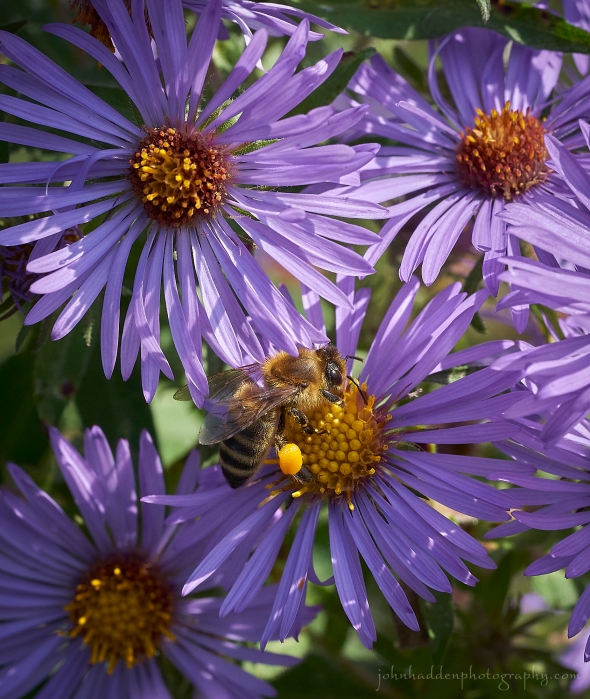 A honey bee works some New England asters
Happy Equinox!
Morning Observation:
This morning in North Hero at 6:50AM it’s currently 60 degree under mostly cloudy skies. Winds are out of the south at 7-10 mph. Relative humidity is 85%, dewpoint 56, barometric pressure 30.29”. Yesterday’s high was 70, and yesterday’s low was 55. The overnight low got down to 60.
This morning in Huntington it’s currently 45 degrees under mostly cloudy skies. Winds are calm. Relative humidity is 97%, dewpoint 44, barometric pressure 30.33”. Yesterday’s high was 75, and yesterday’s low was 40. The overnight low got down to 44.
Forecast Discussion:
High clouds will be on the increase today as what is now Tropical Storm Ophelia slowly moves northward up the Atlantic coast and then hooks eastward into the Mid Atlantic on Sunday. This system is expected to remain well to our south through the weekend with the only expected impacts in Vermont being high clouds and a slight chance for some showers or sprinkles in far southern Vermont later tonight into Sunday. High pressure will build onto the eastern US Monday and dominate our weather clear through to next weekend with dry and seasonable conditions expected.
3-Day Forecast:
We’ll see partly sunny skies today with a high near 70 with south winds 6-11 mph becoming light and variable in the afternoon. Tonight should be mostly cloudy with a low around 54 and light north winds.
Sunday should be mostly cloudy with a high near 69 and northwest winds around 5 mph. Sunday night should be mostly cloudy with a low around 52 and north winds 5-10 mph.
Monday should be mostly sunny with a high near 71 and north winds 5-10 mph. Monday night should be mostly clear with a low around 45 in Huntington and 52 in North Hero with northeast winds 6-13 mph.
Almanac:
Last year on this date in Huntington we had a high of 49 and a low of 36. We picked up 0.02″ of rain.
Last year in North Hero we had a high of 54 and a low of 45.
Burlington averages for this date are a low of 50 and a high of 69.
The record low was 29 in 1963.
The record high was 86 in 2021 (we had a high of 81 in Huntington and 78 in North Hero).
The Lake Champlain lake level in Burlington is 97.06′.
The water temperature is 68˚.
Last year’s lake level was at 94.63′.
Sky Notes:
Sunrise: 6:40AM
Sunset: 6:47PM
Length of day: 12:07:50
Today will be 3:02 shorter than yesterday.
The Autumnal Equinox occurred early this morning at 2:50AM. This marks the point in the earth’s orbit around the sun when earth’s axial tilt is perpendicular to the sun and day and night are just about equal in length (but not quite. Click here for more on this…) It marks the first day of astronomical fall for the northern hemisphere (spring for the south). Here’s a handy graphic showing the axial tilt of the earth’s pole and its relationship to the sun.
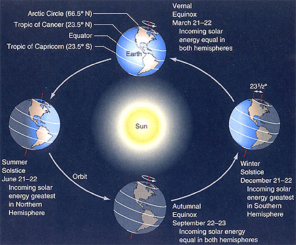
NASA has also released a neat satellite compilation showing the equinoxes and solstices. You can see it here.
The Moon is waxing gibbous, 8 days old with 55% illumination.
Moonrise: 3:53PM
Moonset: 11:59PM
About Today’s Photo:
New England asters are cranking out the blossoms now, and you’ll find these native perennials in fields and along roadsides providing a burst of color. Asters and other late season flowers provide an important source of food for pollinators before winter arrives. Note the pollen-laden “jodhpurs” or corbicula on the bee’s hind legs.
Sony A7II, Sony 90mm macro lens, ISO 1250, f/13, 1/500″ exposure
Friday, September 22, 2023
 A shaggy rock on our shore
Morning Observation:
This morning in Huntington at 7:05AM it’s currently 41 degrees under clear skies. Winds are calm. Relative humidity is 97%, dewpoint 40, barometric pressure 30.42”. Yesterday’s high was 70, and yesterday’s low was 40. The overnight low got down to 40.
This morning in North Hero it’s currently 57 degrees under mostly clear skies. Winds are out of the south at 6-8 mph. Relative humidity is 93%, dewpoint 55, barometric pressure 30.37”. Yesterday’s high was 68, and yesterday’s low was 52. The overnight low got down to 55.
Forecast Discussion:
We’ve got another day of lovely fall weather ahead of us courtesy of high pressure cresting over the region. Clouds will be on the increase tonight as the high slides to our east and our next weather system approaches along the Atlantic seaboard. Was may potentially be dubbed Tropic Cyclone 16 (now there’s a name for ya…) is expected to move up the coast on Saturday. As with previous forecast model runs, there’s still some disagreement over how far north the storm will push with the North American (NAM) and Global (GFS) models keeping the precipitation shunted to our south while the European (ECMWF) and Canadian (CAN) models both bring some precipitation into parts of southern and central Vermont. At this point the NWS has gone with a blend of these solutions with a chance of showers over southern Vermont later in the day Saturday into Sunday. The storm is expected to move to our south and east by Monday with another stretch of dry and seasonable weather expected through next week!
3-Day Forecast:
We’ll see sunny skies today with a high near 70 and south winds 6-8 mph. Tonight should be partly cloudy with a low around 49 in Huntington and 55 in North Hero with south winds 6-12 mph.
Saturday should be mostly sunny with a high near 68 and south winds 6-11 becoming light in the afternoon. Saturday night should be mostly cloudy with a low around 54 and northeast winds 3-6 mph.
Sunday should be mostly cloudy with a high near 67 and north winds around 5-7 mph. Sunday night should be mostly cloudy with a 30% chance of showers in Huntington. Lows will be around 50 with north winds 6-8 mph.
Almanac:
Last year on this date in Huntington we had a high of 66 and a low of 47. We picked up 0.69″ of rain.
Last year in North Hero we had a high of 68 and a low of 50. We picked up 0.81″ of rain.
Burlington averages for this date are a low of 51 and a high of 70.
The record low was 31 in 1962.
The record high was 88 in 1965.
The Lake Champlain lake level in Burlington is 97.12′.
The water temperature is 67˚.
Last year’s lake level was at 94.52′.
Sky Notes:
Sunrise: 6:38AM
Sunset: 6:49PM
Length of day: 12:10:52
Today will be 3:02 shorter than yesterday.
This is the last day of astronomical summer as the Autumnal Equinox will occur tomorrow morning at 2:50AM.
The Moon is in its first quarter, 7 days old with 44% illumination.
Moonrise: 2:50PM
Moonset: 10:54PM
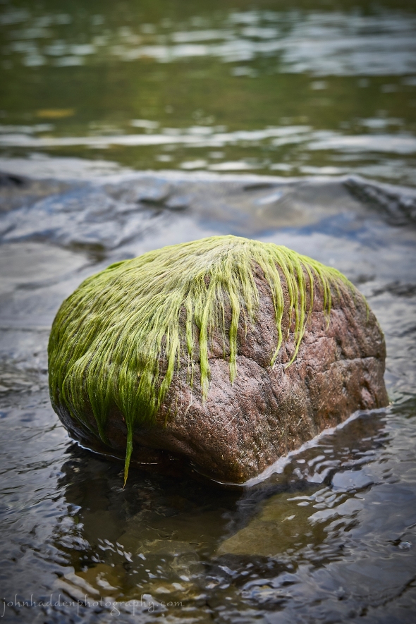
About Today’s Photo:
Lake algae coats a shoreline stone as the lake level slowly drops. I can’t help seeing a person’s head with a shaggy haircut…
Sony A7II, Sony 24-240mm lens @ 63mm, ISO 800, f/8, 1/80″ exposure
Thursday, September 21, 2023

 A honey bee works sedum blossoms in one of our camp gardens
Morning Observation:
This morning in North Hero at 6:50AM it’s currently 53 degrees under clear skies. Winds are light out of the south. Relative humidity is 88%, dewpoint 49, barometric pressure 30.25”. Yesterday’s high was 70, and yesterday’s low was 55. The overnight low got down to 52.
This morning in Huntington it’s currently 40 degrees under clear skies. Winds are calm. Relative humidity is 97%, dewpoint 39, barometric pressure 30.25”. Yesterday’s high was 68, and yesterday’s low was 44. The overnight low got down to 40.
Forecast Discussion:
We’ve got some delightful fall weather ahead of us courtesy of a large area of high pressure building in over the northeast. We’ll see seasonably warm and dry conditions with chilly nights. Highs today are expected to top out in the low 70s with overnight temperatures dropping into the upper 40s over Lake Champlain and into the lower 30s in mountain valleys. The usual cold spots may even pick up a spot of frost. Friday is looking similar with the addition of high clouds building into the region Friday night which will limit radiational cooling so overnight lows shouldn’t be as chilly. As we head into the weekend, we continue to keep an eye on a potent coastal low pressure system expected to move up the mid-Atlantic coast. Forecast models are still in disagreement over the track of the storm with the Global model keeping it well to our south while the European and especially the Canadian models show the storm moving into New England. At this time the NWS is forecasting mostly just clouds with the possibility of showers over southern areas of Vermont for Saturday and early Sunday while northern areas remain dry. We’ll have to see how that plays out. Whatever the case, the storm is expected to move off to the south and east later on Sunday with dry and seasonable conditions expected heading into early next week.
3-Day Forecast:
We’ll see sunny skies today with a high near 68 and northwest winds 5-7 mph. Tonight should be clear with a low around 44 in Huntington and 51 in North Hero with light north winds.
Friday should be sunny with a high near 71 with south winds around 6 mph. Friday night should be partly cloudy with a low around 54 and south winds 6-12 mph.
Saturday should be partly sunny with a high near 69 and south winds 5-9 mph. Saturday night should be mostly cloudy with a low around 53 and light and variable winds.
Almanac:
Last year on this date in Huntington we had a high of 71 and a low of 53. We picked up 0.04″ of rain.
Last year in North Hero we had a high of 68 and a low of 55. We picked up 0.01″ of rain.
Burlington averages for this date are a low of 51 and a high of 70.
The record low was 30 in 1962.
The record high was 85 in 1965.
The Lake Champlain lake level in Burlington is 97.18′.
The water temperature is 66˚.
Last year’s lake level was at 94.47′.
Sky Notes:
Sunrise: 6:37AM
Sunset: 6:51PM
Length of day: 12:13:55
Today will be 3:02 shorter than yesterday.
The Moon is a waxing crescent, 6 days old with 34% illumination.
Moonrise: 1:46PM
Moonset: 9:59PM
About Today’s Photo:
The sedum that Robin planted in one of our camp flower beds is bursting with blossoms now, and the honey bees and other pollinators are taking full advantage of its late season bounty!
Sony A7II, Sony 90mm macro lens, ISO 1250, f/5, 1/100″ exposure
Wednesday, September 20, 2023

 Nature’s mandala
Morning Observation:
This morning in North Hero at 7:35AM it’s currently 60 degrees under clear skies. Winds are light out of the west. Relative humidity is 77%, dewpoint 53, barometric pressure 30.06”. We picked up 0.04” of rain yesterday. Yesterday’s high was 62, and yesterday’s low was 59. The overnight low got down to 55.
This morning in Huntington it’s currently 47 degrees under clear skies. Winds are calm. Relative humidity is 97%, dewpoint 46, barometric pressure 30.10”. We picked up 0.30” of rain yesterday. Yesterday’s high was 61, and yesterday’s low was 56. The overnight low got down to 46.
Forecast Discussion:
High pressure building into the region will bring us an extended period of dry and seasonable weather through the remainder of the week and into the weekend. Highs today will range through the 60s, into the low 70s on Thursday, and mid 70s by Friday as a bit of a warming trend occurs. Forecast models are in a bit of disagreement about the track of a storm system expected to move up the mid-Atlantic coast this weekend with both the European and Global models keeping the storm to our south, while the Canadian models shows the storm moving into New England. At this point the NWS is calling for dry conditions Saturday with increasing clouds Saturday night into Sunday. We’ll have to wait to see what sugars out…
3-Day Forecast:
We’ll see sunny skies today with a high near 66 and west winds 5-9 mph. Tonight should be mostly clear with a low around 45 in Huntington and 54 in North Hero with west winds 7-9 mph.
Thursday should be sunny with a high near 69 and northwest winds around 6 mph. Thursday night should be mostly clear with a low around 45 in Huntington and 50 in North Hero with light southeast winds.
Friday should be sunny with a high near 72 and south winds 5-9 mph. Friday night should be mostly clear with a low around 48 and south winds 6-10 mph.
Almanac:
Last year on this date in Huntington we had a high of 64 and a low of 58. We picked up 0.16″ of rain.
Last year in North Hero we had a high of 58 and a low of 56. We picked up 0.22″ of rain.
Burlington averages for this date are a low of 51 and a high of 71.
The record low was 30 in 1979.
The record high was 89 in 1946.
The Lake Champlain lake level in Burlington is 97.21′
The water temperature is 66˚.
Last year’s lake level was at 94.33′.
Sky Notes:
Sunrise: 6:36AM
Sunset: 6:53PM
Length of day: 12:16:57
Today will be 3:02 shorter than yesterday.
The Moon is a waxing crescent, 5 days old with 24% illumination.
Moonrise: 12:34PM
Moonset: 9:19PM
About Today’s Photo:
Hens and chicks (hen-widdies in the southern US!) are a popular succulent in gardens. Native to southern Europe and northern Africa, these low growing perennials launch tall flowering stalks. The plants have been used in ways similar to aloe for skin irritation and burns.
Sony A7II, Sony 24-240mm lens @ 139mm, ISO 1250, f/8, 1/40″ exposure
Tuesday, September 19, 2023

 Still life with fishbone and shale
Morning Observation:
This morning in North Hero at 7:50AM it’s currently 60 degrees under overcast skies. Winds are light out of the west. Relative humidity is 94%, dewpoint 58, barometric pressure 29.71”. We picked up 0.01” of rain yesterday and 0.02” so far today. Yesterday’s high was 67, and yesterday’s low was 61. The overnight low got down to 59.
This morning in Huntington it’s currently 58 degree under overcast skies. Winds are calm. Relative humidity is 97%, dewpoint 57, barometric pressure 29.74”. We picked up 0.20” of rain yesterday and 0.13” so far today. Yesterday’s high was 60, and yesterday’s low was 54. The overnight low got down to 57.
Forecast Discussion:
We’ve got a grey, cool, and damp fall day on tap for today courtesy of two weather systems. A trough moving through southern Ontario and a second coastal low will both contribute to showery conditions through the day today, especially over northern sections. Highs today will range through the 60s. High pressure is expected to build in on Wednesday bringing an extended period of dry and seasonable conditions through the rest of the week and most of the weekend. Forecast models are in a bit of disagreement over the track of a system expected to pass to our south in the Saturday night/Sunday timeframe, so we may or may not see some rain from that one. Stay tuned…
3-Day Forecast:
We’ll see cloudy skies today with showers likely. Highs will be near 61 with west winds 8-15 mph. Chance of precipitation is 70% with rainfall amounts between 0.10″-0.25″ possible. Tonight should be cloudy with a 30% chance of showers before 8:00PM. Skies should gradually become partly cloudy with a low around 50 and northwest winds 5-11 mph. Rainfall amounts of less than 0.10″ are possible.
Wednesday should be sunny with a high near 67 and west winds 5-10 mph. Wednesday night should be mostly clear with a low around 50 and north winds 6-10 mph becoming southwesterly after midnight.
Thursday should be sunny with a high near 70 and northwest winds around 6 mph. Thursday night should be mostly clear with a low around 50 and light south winds.
Almanac:
Last year on this date in Huntington we had a high of 67 and a low of 58. We picked up 2.26″ of rain.
Last year in North Hero we had a high of 63 and a low of 55. We picked up 0.67″ of rain.
Burlington averages for this date are a low of 52 and a high of 71.
The record low was 32 in 2014 (We had a low of 28 in Huntington).
The record high was 85 in 2015 (we had a high of 81 in Huntington).
The Lake Champlain lake level in Burlington is 97.23′.
The water temperature is 68˚.
Last year’s lake level was at 94.16′.
Sky Notes:
Sunrise: 6:35AM
Sunset: 6:55PM
Length of day: 12:19:59
Today will be 3:02 shorter than yesterday.
The Moon is a waxing crescent, 4 days old with 16% illumination.
Moonrise: 11:21AM
Moonset: 8:48PM
About Today’s Photo:
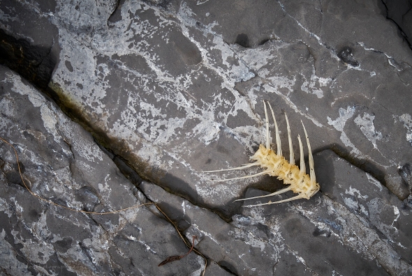
I came across this bit of fishbone the other day along with a few others scattered about the shale beach. I’d seen a flash of eagle taking off from near this location below our porch earlier in the morning, and I suspect that the eagle was responsible for the bones…
Sony A7II, ISO 1250, f/8, 1/125″ exposure
Sunday, September 17, 2023

 A darner dragonfly alights on a cedar in our front yard at camp
Morning Observation:
This morning in North Hero at 7:10AM it’s currently 59 under partly cloudy skies. Winds light out of the south. Relative humidity is 88%, dewpoint 55, barometric pressure 29.85”. Yesterday’s high was 72, and yesterday’s low was 57. The overnight low got down to 57.
This morning in Huntington it’s currently 46 degrees under partly cloudy skies. Winds are calm. Relative humidity is 97%, dewpoint 45, barometric pressure 29.90”. Yesterday’s high was 69, and yesterday’s low was 49. The overnight low got down to 45.
Forecast Discussion:
We’ve got another lovely early fall day on tap courtesy of high pressure which is sliding to our east. Clouds will be on the increase during the day today out ahead of an area of low pressure approaching from the Great Lakes. Showers will push into the region overnight and into Monday. Meanwhile, a coastal low is expected to move up the coast on Monday and perhaps bring a few showers mostly to eastern areas during the day on Monday and into early Tuesday. A broad area of Canadian high pressure will build in starting Tuesday bringing an extended period of dry and seasonably mild weather during into next weekend.
3-Day Forecast:
We’ll see partly sunny skies today with a high near 73 and south winds 5-7 mph. Tonight should be mostly cloudy with showers likely late. Lows will be around 55 with south winds 7-10 mph. Chance of precipitation is 60% with rainfall amounts of less than 0.10″ possible.
Monday should be mostly cloudy with showers likely, mainly before 11:00AM. Highs will be near 68 with southeast winds around 6 mph becoming northwest around 5 mph in the afternoon. Chance of precipitation is 60% with rainfall amounts between 0.10″-0.25″ possible. Monday night should be cloudy with showers likely. Lows will be around 53 with north winds 7-9 mph. Chance of precipitation is 60% with rainfall amounts between 0.25″-0.50″ possible.
Tuesday should be cloudy through midmorning with a 40% chance of showers before 1:00PM. Skies should gradually with a high near 63 and northwest winds 7-10 mph in Huntington and 11-15 mph over Lake Champlain gusting to 21 mph. Rainfall amounts between 0.10″-0.25″ are possible. Tuesday night should be partly cloudy with a low around 50 and west winds 5-9 mph.
Almanac:
Last year on this date in Huntington we had a high of 64 and a low of 39.
Last year in North Hero we had a high of 67 and a low of 50.
Burlington averages for this date are a low of 53 and a low of 72.
The record low was 34 in 1961.
The record high was 87 in 2018 (we had a high of 84).
The Lake Champlain lake level in Burlington is 97.43′.
The water temperature is 67˚.
Last year’s lake level was at 94.23′.
Sky Notes:
Sunrise: 6:33AM
Sunset: 6:59PM
Length of day: 12:26:03
Today will be 3:01 shorter than yesterday.
The Moon is a waxing crescent, 2 days old with 5% illumination.
Moonrise: 9:33AM
Moonset: 8:42PM
About Today’s Photo:
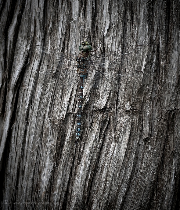
I’ve been watching a pair of darner dragonflies (perhaps black-tipped? WJ?) engaged in their mating flights for the past few days at camp. They’ll fly through the air coupled tail to tail and then break apart. This one of the pair took a rest break on one of the cedars in our waterside yard.
iPhone 12 Pro
Saturday, September 16, 2023

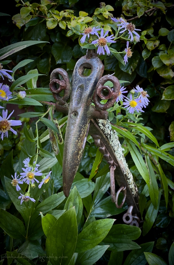 A cagey bird hiding amongst the asters
Morning Observation:
This morning in North Hero at 7:25AM it’s currently 58 degrees under partly cloudy skies. Winds are calm. Relative humidity is 88%, dewpoint 54, barometric pressure 29.93”. Yesterday’s high was 71, and yesterday’s low was 52. The overnight low got down to 57.
This morning in Huntington it’s currently 50 degrees under mostly cloudy skies. Winds are calm. Relative humidity is 97%, dewpoint 49, barometric pressure 29.93”. Yesterday’s high was 65, and yesterday’s low was 45. The overnight low got down to 49.
There is a Lake Wind Advisory in effect today through midnight tonight.
Forecast Discussion:
The remnants of Hurricane Lee, now an extra-tropical depression, are currently spinning off the coast of Maine south of Nova Scotia and the Bay of Fundy where it is expected to make landfall later today. Impacts across Vermont from the storm should be minimal today with perhaps a few showers or sprinkles over far eastern areas and some gusty north winds. Winds are expected to gust up to 30-40 mph east of the Greens, 25-35 mph in the Champlain Valley, and 50-60 mph over mountain summits. There is a Lake Wind Advisory in effect today through midnight tonight. Winds should wind down quickly after sunset tonight as the storm lifts into the Gulf of St. Lawrence. Dry and seasonable conditions are expected for Sunday. Low pressure tracking up The Atlantic seaboard Monday will bring some showers to the region Monday into Tuesday. Expansive high pressure is expected to build in thereafter bringing dry and seasonable condition through the end of next week.
3-Day Forecast:
We’ll see cloudy skies today with a high near 69 and gusty north winds 6-16 mph in Huntington and 18-20 mph over Lake Champlain. Tonight should start out mostly cloudy, then gradually become clear, with a low around 49 and northwest winds 10-15 mph diminishing overnight.
Sunday should be sunny with a high near 72 and west winds 5-8 mph becoming light and variable. Sunday night should be mostly cloudy with a 30% chance of showers late. Lows will be around 57 with light south winds.
Monday should be mostly cloudy with a 40% chance of showers. Highs will be near 67 ad south winds 5-7 becoming light and variable. Rainfall amounts of less than 0.10″ are possible. Monday night should be mostly cloudy with a 50% chance of showers. Lows will be around 55 and north winds 3-5 mph. Rainfall amounts of less than 0.10″ are possible.
Almanac:
Last year on this date in Huntington we had a high of 64 and a low of 39.
Last year in North Hero we had a high of 69 and a low of 53.
Burlington averages for this date are a low of 53 and a high of 73.
The record low was 30 in 1964.
The record high was 87 in 2018 (we had a high of 86 in Huntington).
The Lake Champlain lake level in Burlington is 97.48′.
The water temperature is 69˚.
Last year’s lake level was at 94.26′.
Sky Notes:
Sunrise: 6:31AM
Sunset: 7:01PM
Length of day: 12:29:05
Today will be 3:01 shorter than yesterday.
The Moon is a waxing crescent, 1 day old with 1% illumination.
Moonrise: 8:31AM
Moonset: 8:22PM
About Today’s Photo:
I just had to take a pic of one of our Abbot Lovett birds sculptures peeking out from behind a bunch of asters by our garage. Peek-a-boo!
iPhone 12 Pro
Thursday, September 14, 2023

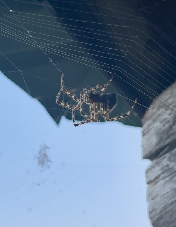 A large orb-weaver off our camp porch
Morning Observation:
This morning in Huntington at 6:55AM it’s currently 48 degrees under partly cloudy skies. Winds are calm. Relative humidity is 97%, dewpoint 47, barometric pressure 30.02”. We picked up 0.51” of rain yesterday. Yesterday’s high was 70, and yesterday’s low was 58. The overnight low got down to 48.
This morning in North Hero it’s currently 58 degrees under mostly clear skies. Winds are out of the south at 2-4 mph. Relative humidity is 90%, dewpoint 55, barometric pressure 29.99”. We picked up 0.75” of rain yesterday. Yesterday’s high was 70, and yesterday’s low was 60. The overnight low got down to 56.
Forecast Discussion:
High pressure to our west will build into the region bringing dry and seasonably cool conditions today and Friday. Highs today will be in the mid 60s with a cool night expected with good radiational cooling. Hurricane Lee continues its track northward and expected to make landfall as an extra-tropical depression on Saturday near the Bay of Fundy. Impacts on Vermont are expected to be minimal with perhaps some light showers in far eastern Vermont Saturday along with some gusty north winds. Winds should generally be 15-25 mph gusting to 35-45 mph in the Connecticut River valley and 15-20 mph gusting to 20-25 mph in the Champlain Valley. The storm is expected to move into the Gulf of St. Lawrence by Sunday allowing high pressure to build in briefly for Sunday into Monday. Low pressure approaching from the Great Lake on Monday will bring another round of showers before high pressure builds back in for the middle of next week with dry and seasonable conditions expected.
3-Day Forecast:
We’ll see mostly sunny skies today with a high near 64 and west winds 5-9 mph. Tonight should be partly cloudy with a low around 45 in Huntington and 51 in North Hero with northwest winds 5-7 mph becoming calm in the evening.
Friday should be mostly sunny with a high near 67 and northwest winds 8-13 mph. Friday night should be mostly cloudy with a low around 51 and north winds 8-10 mph.
Saturday should be mostly cloudy with a high near 66 and north winds 10-17 mph gusting to 28 mph in Huntington. Saturday night should be mostly cloudy with a low around 50 and northwest winds 10-18 mph gusting to 29 mph in Huntington.
Almanac:
Last year on this date in Huntington we had a high of 75 and a low of 58. We picked up 0.04″ of rain.
Last year in North Hero we had a high of 75 and a low of 57. We picked up 0.05″ of rain.
Burlington averages for this date are a low of 54 and a high of 74.
The record low was 32 in 1963.
The record high was 87 in 2005 (we had a high of 76 in Huntington).
The Lake Champlain lake level in Burlington is 97.54′.
The water temperature is 70˚.
Last year’s lake level was at 94.22′.
Sky Notes:
Sunrise: 6:29AM
Sunset: 7:04PM
Length of day: 12:35:08
Today will be 3:01 shorter than yesterday.
The Moon is new, 0 days old with 0% illumination.
Moonrise: 5:49AM
Moonset: 7:13PM
About Today’s Photo:
I came across this large orb-weaver spider in residency in the eves of our camp porch the other day. It had staked out a prime location on the windward side of the porch where many a tasty insect would stumble into its large web.
iPhone 12 Pro
Wednesday, September 13, 2023

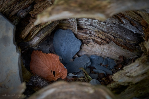 A leaf and some stones tucked in a hollow log along the beach
Morning Observation:
This morning in North Hero at 7:00AM it’s currently 67 degrees under clear skies. Winds are out of the south at 2-3 mph. Relative humidity is 91%, dewpoint 64, barometric pressure 29.88”. Yesterday’s high was 73, and yesterday’s low was 60. The overnight low got down to 67.
This morning in Huntington it’s currently 62 degrees under clear skies. Winds are calm. Relative humidity is 98%, dewpoint 61, barometric pressure 29.91”. Yesterday’s high was 79, and yesterday’s low was 59. The overnight low got down to 59.
Forecast Discussion:
Morning radar imagery shows low pressure just south of James Bay with a band of showers stretched along an approaching cold front situated just about over Ottawa. Showers have already started to push into southwestern Vermont at this hour and are expected to overspread the region during the day today. Showers should be on the lighter side, but some thunderstorms may develop this afternoon bringing some brief heavier downpours. The front is expected to clear the region this evening while the parent low continues to circulate a bit more moisture into the region overnight. High pressure is expected to build in on Thursday into Friday bringing dry and seasonably cool conditions. Hurricane Lee—currently east of the Bahamas—will continue its northward track off The Atlantic Coast arriving into New England waters on Saturday as an extratropical depression. At this point, forecasts are fairly confident that the storm will make landfall in Downeast Maine. Impacts in Vermont should be minimal with some rain likely in the Connecticut Valley eastward along with some breezing conditions. Winds in the Connecticut Valley corridor may gust into the 25-35 mph range on Saturday, with perhaps 20-25 mph in the Champlain Valley, and 25-40 mph over the spine of the Greens. The storm is expected to make a fast exit into the Gulf of St. Lawrence by Sunday with dry conditions expected Sunday. The next chance of showers arrives Monday as low pressure approaches from the Great Lakes.
3-Day Forecast:
We’ll see cloudy skies today with showers likely before noon with thunderstorm possible this afternoon. Highs will be near 69 with south winds 5-8 mph. Chance of precipitation is 70% with rainfall amounts between 0.25″-0.50″ possible. Tonight should be mostly cloudy with a 40% chance of showers, mainly before 10:00PM. Lows will be around 54 with east winds 5-10 mph becoming northwesterly after midnight. Rainfall amounts of less than 0.10″ are possible.
Thursday should be partly sunny with a high near 66 and southwest winds 5-9 mph. Thursday night should be mostly cloudy with a low around 48 and northwest winds 6-10 mph.
Friday should be partly sunny with a high near 68 and north winds 6-10 mph. Friday night should be mostly cloudy with a low around 51 and north winds 7-12 mph.
Almanac:
Last year on this date in Huntington we had a high of 75 and a low of 61. We picked up 3.75″ of rain (!!!)
Last year in North Hero we had a high of 73 and a low of 62. We picked up 1.23″ of rain.
Burlington averages for this date are a low of 54 and a high of 74.
The record low was 31 in 1941.
The record high was 92 in 1948.
The Lake Champlain lake level in Burlington is 97.53′.
The water temperature is 72˚.
Last year’s lake level was at 94.17′.
Sky Notes:
Sunrise: 6:28AM
Sunset: 7:06PM
Length of day: 12:38:09
Today will be 3:00 shorter than yesterday.
The Moon is a waning crescent, 28 days old with 3% illumination.
Moonrise: 4:46AM
Moonset: 6:57PM
About Today’s Photo:
While exploring the beach the other day, I came across a hollowed-out cottonwood logs lying on its side along the shore. A small cavity invited snooping, and I found this one basswood leaf along with a few bits of slate hiding inside.
Sony A7II, Sony 24-240mm lens @ 181mm, ISO 1250, f/6.3, 1/80″ exposure
Tuesday, September 12, 2023

 Basswood leaves, stone, and shale
Morning Observation:
This morning in North Hero at 7:05AM it’s currently 61 degrees under overcast skies. There’s plenty of low clouds/fog to our south and east this morning. Winds are calm. Relative humidity is 98%, dewpoint 60, barometric pressure 29.97”. Yesterday’s high was 68, and yesterday’s low was 60. The overnight low got down to 60.
This morning in Huntington it’s currently 60 degrees under low overcast skies. Winds are calm. Relative humidity is 98%, dewpoint 60, barometric pressure 30.01”. We picked up 0.05” of rain yesterday. Yesterday’s high was 65, and yesterday’s low was 61. The overnight low got down to 60.
Forecast Discussion:
A quasi-stationary front is currently draped to the east and south of the Vermont this morning and is helping to created low clouds and areas of dense fog in valley locations. Clouds and some sprinkles will persist over parts of southern Vermont through the day today with northern areas staying mostly dry until later this afternoon. Low pressure approaching from the northern Great Lakes will drag a sharp cold front through the region on Wednesday. Showers are expected to push into Vermont later this afternoon/evening with a more widespread, steady rain expected for most of the day on Wednesday as the front crosses the region. The cold front is expected to push eastward by Wednesday night with showers tapering off by midnight. The aforementioned parent low will lift to our northeast Thursday keeping some clouds and widely scattered showers hanging around though midday on Thursday. Strong high pressure is expected to build in later Thursday into Friday bringing seasonably cool and dry conditions. Heading into the weekend, the focus continues to be on Hurricane Lee which should have diminished to an extra tropical cyclone by then. Current model predictions see the storm moving into the waters off the New England coast by Saturday, but staying well enough to the east to have minimal impacts on Vermont. Little or no rain expected at this time, but we may see some breezy conditions. Again, it’s worth keeping an eye on this storm as subtle changes in the steering surface winds could make a difference in the track of the storm. High pressure is expected to return by Sunday with another round of showers expected later on Monday.
3-Day Forecast:
We’ll see mostly cloudy skies today with a 30% chance of showers this afternoon. Highs will be near 74 with calm winds becoming southerly 5-7 mph in the afternoon. Tonight should be mostly cloudy with a 40% chance of showers. Lows will be around 62 with south winds around 7 mph in Huntington and 9-13 mph over Lake Champlain. Rainfall amounts of less than 0.10″ are possible.
Wednesday should be cloudy with showers and possibly an afternoon thunderstorm. Highs will be near 70 with south winds 5-9 mph. Chance of precipitation is 80% with rainfall amounts between 0.25″-0.50″ possible. Wednesday night should be mostly cloudy with showers likely, mainly before 8:00PM. Lows will be around 55 with northwest winds 4-9 mph. Chance of precipitation is 60% with rainfall amounts between 0.10″-0.25″ possible.
Thursday should be partly sunny with a high near 66 and northwest winds 5-8 mph. Thursday night should be partly cloudy with a low around 52 and northwest winds 6-9 mph.
Almanac:
Last year on this date in Huntington we had a high of 81 and a low of 60.
Last year in North Hero we had a high of 79 and a low of 67.
Burlington averages for this date are a low of 54 and a high of 74.
The record low was 37 in 1967.
The record high was 90 in 1947.
The Lake Champlain lake level in Burlington is 97.59′
The water temperature is 67˚.
Last year’s lake level was at 94.17′.
Sky Notes:
Sunrise: 6:27AM
Sunset: 7:08PM
Length of day: 12:41:10
Today will be 3:00 shorter than yesterday.
The Moon is a waning crescent, 27 days old with 7% illumination.
Moonrise: 3:40AM
Moonset: 6:38PM
About Today’s Photo:
This cluster of basswood leaves were caught between larger stones on the beach. I like the strong color and tonal contrasts of the various surfaces.
Sony A7II, Sony 24-240mm lens @ 77mm, ISO 1250, f/13, 1/50″ exposure
Monday, September 11, 2023

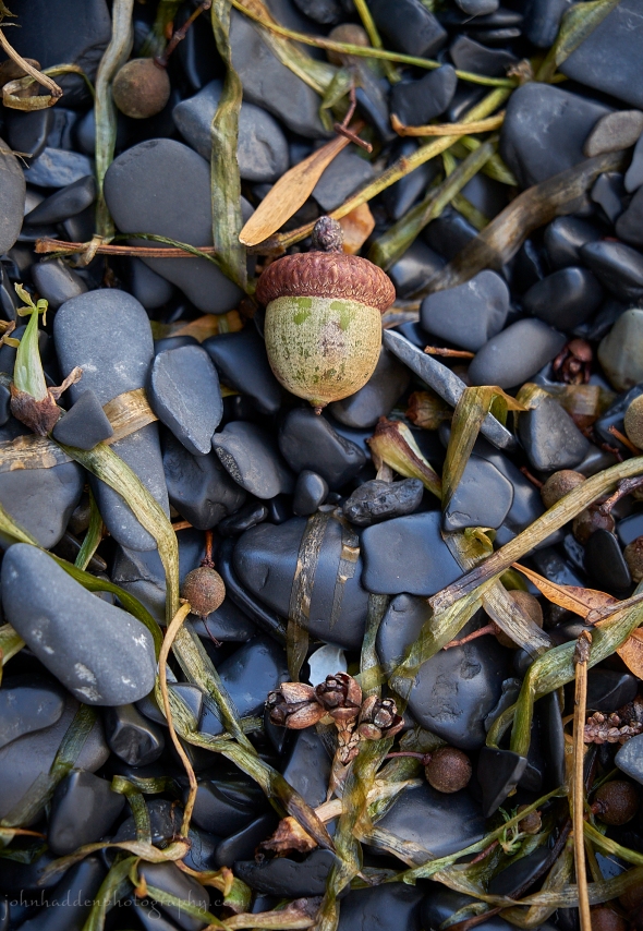 Beach still life with grass and seeds
Morning Observation:
This morning in North Hero at 7:30AM it’s currently 60 degree under overcast skies. Winds are calm. Relative humidity is 97%, dewpoint 60, barometric pressure 30.05”. We picked up 0.85” of rain yesterday. Yesterday’s high was 67, and yesterday’s low was 61. The overnight low got down to 60.
This morning in Huntington it’s currently 61 degrees under low overcast skies. Winds are calm. Relative humidity is 97%, dewpoint 60, barometric pressure 30.07”. We picked up 0.61” of rain yesterday and 0.02” so far today. Yesterday’s high was 74, and yesterday’s low was 59. The overnight low got down to 61.
Forecast Discussion:
A quasi-stationary front is draped across Vermont at this hour and will act as rails for some light rain showers, mostly over southwestern to northeastern sections this morning. Precipitation should wind down by midday with dry conditions expected for most of Vermont tonight into Tuesday morning. Low pressure tracking out of the Great Lakes will bring renewed chances for showers later in the day on Tuesday with widespread rain expected for much of Wednesday. High pressure will begin to push into the region by Thursday bringing dry conditions into the upcoming weekend. Forecasters continue to monitor the track of Hurricane Lee as it makes its way northward along The Atlantic seaboard. At this point, it’s looking like the storm will be making a glancing blow at eastern New England along Down East Maine. It’s still too early to be sure—we may see just some extra high elevation winds from the storm, or we may get some rain as well. Stay tuned…
3-Day Forecast:
We’ll see cloudy skies today with a 30% chance of morning showers. Highs will be near 70 with northwest 5-9 mph. Tonight should be mostly cloudy with patchy dense fog. Lows will be around 60 with north winds 3-7 mph.
Tuesday should be mostly cloudy with a 20% chance of afternoon showers. Highs will be near 75 with south winds around 5 mph. Tuesday night should be mostly cloudy with a 40% chance of showers. Lows will be around 63 with south winds 5-8 mph in Huntington and 8-17 mph over Lake Champlain. Rainfall amounts between 0.10″-0.25″ are possible.
Wednesday should be cloudy with showers likely. Highs will be near 68 with south winds 6-12 mph. Chance of precipitation is 80% with rainfall amounts between 0.50”-0.75” possible. Wednesday night should be cloudy with showers, mainly before 8:00PM. Lows will be around 55 with south winds 6-10 mph becoming westerly after midnight. Chance of precipitation is 80% with rainfall amounts between 0.25″-0.50″ possible.
Almanac:
Last year on this date in Huntington we had a high of 82 and a low of 56.
Last year in North Hero we had a high of 77 and a low of 66.
Burlington averages for this date are a low of 55 and a high of 75.
The record low was 34 in 1967.
The record high was 91 in 2013 (we had a high of of 88 in Huntington).
The Lake Champlain lake level in Burlington is 97.59′.
The water temperature is 70˚.
Last year’s lake level was at 94.20′.
Sky Notes:
Sunrise: 6:26AM
Sunset: 7:10PM
Length of day: 12:44:10
Today will be 3:00 shorter than yesterday.
The Moon is a waning crescent, 26 days old with 12% illumination.
Moonrise: 2:34AM
Moonset: 6:15PM
About Today’s Photo:
The neutral grey palette of the shale beach pebble offers a lovely background for a variety of nuts and seeds scattered on the shore with a smattering of lake grasses included.
Sony A7II, Sony 24-240mm lens @ 240mm, ISO 1250, f/8, 1/60″ exposure.
Sunday, September 10, 2023

 A rain-bedecked fuchsia
Morning Observation:
This morning in North Hero at 7:40AM it’s currently 63 degrees and raining lightly under overcast skies. Winds are calm. Relative humidity is 96%, dewpoint 62, barometric pressure 30.06”. We picked up 0.57” of rain so far today. Yesterday’s high was 72, and yesterday’s low was 61. The overnight low got down to 62.
This morning in Huntington it’s currently 62 degrees under overcast skies. Winds are calm. Relative humidity is 97%, dewpoint 61, barometric pressure 30.10”. We picked up 0.03” of rain yesterday and 0.42” so far today. Yesterday’s high was 75, and yesterday’s low was 59. The overnight low got down to 59.
Forecast Discussion:
We’ve got an active weather day ahead of us as a trough lifts through the region bringing widespread showers and some afternoon thunderstorms to the region. An associated weak warm from will lift through the region this afternoon increasing chances for thunderstorms and some potential flash flooding. A weak ridge is expected to build in on Monday bringing a relatively dry day with seasonable temperatures. Dry conditions will linger through most of Tuesday before the next round of heavy rains is expected to arrive Tuesday night. Low pressure tracking through southern Ontario & Québec will bring a widespread soaking rains Wednesday and into Thursday morning. At this point, the weekend is looking dry and seasonable. We continue to keep an eye on Hurricane Lee: models are beginning to show a bit more consensus that the storm should stay off shore as it moves by over the weekend. Fingers crossed…
3-Day Forecast:
We’ll see cloudy skies today with showers and afternoon thunderstorms. Highs will be near 70 with north winds 6-14 mph over Lake Champlain. Chance of precipitation is 80% with rainfall amounts between 0.25″-0.50″ possible. Tonight should be cloudy with showers and possibly a thunderstorm. Lows will be around 60 with north winds 8-10 mph. Chance of precipitation is 80% with rainfall amounts between 0.25″-0.50″ possible.
Monday should be mostly cloudy with a 40% chance of showers, mainly before 1:00PM. Highs will be near 70 with northwest winds 6-10 mph. Rainfall amounts of less than 0.10″ are possible. Monday night should be mostly cloudy with a low around 57 and north winds 5-7 mph.
Tuesday should be mostly cloudy with a high near 75 and north winds 5-8 mph becoming southerly in the afternoon. Tuesday night should be cloudy with showers likely late. Lows will be around 60 with south winds 9-11 mph. Chance of precipitation is 70% with rainfall amounts between 0.10″-0.25″ possible.
Almanac:
Last year on this date in Huntington we had a high of 84 and a low of 54.
Last year in North Hero we had a high of 81 and a low of 66.
Burlington averages for this date are a low of 55 and a high of 75.
The record low was 35 in 1978.
The record high was 93 in 2002 (we had a high of 88 in Huntington).
The Lake Champlain lake level in Burlington is 97.58′.
The water temperature is 72˚.
Last year’s lake level was at 94.21′.
Sky Notes:
Sunrise: 6:24AM
Sunset: 7:12PM
Length of day: 12:47:11
Today will be 3:00 shorter than yesterday.
The Moon is a waning crescent, 25 days old with 19% illumination.
Moonrise: 1:29AM
Moonset: 5:47PM
About Today’s Photo:
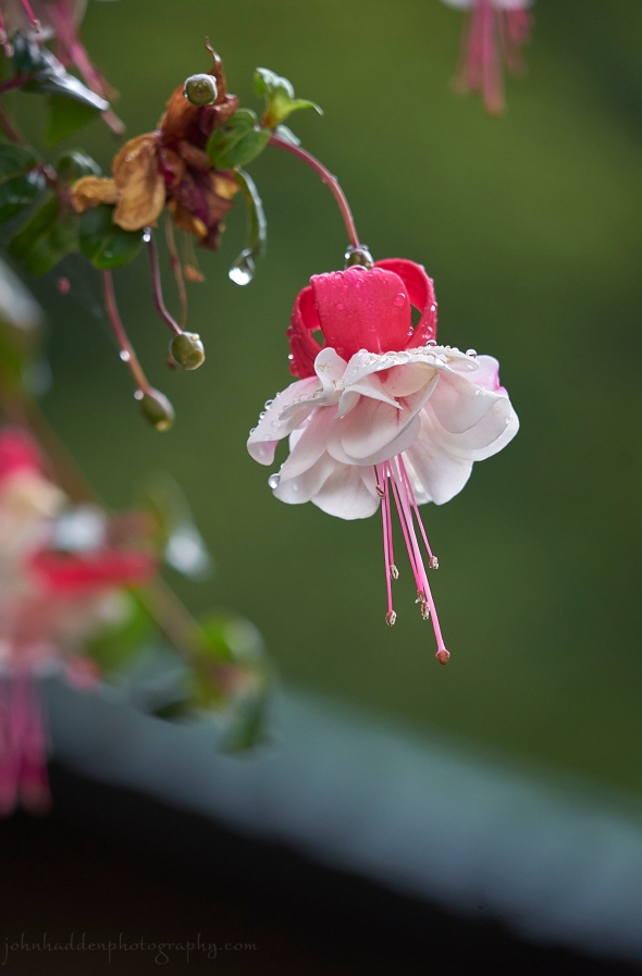
Fuchsias occur in the wild as small shrubs native to Central America. As most known, they’ve become a go-to favorite for decorative hanging baskets here in the North Country as there are almost 110 different species in a wide range of colors. The plant gets its name from one Leonhart Fuchs (1501-1566), a noted German physician and botanist.
Sony A7II, Sony 24-240mm lens @ 240mm, ISO 1250, f/6.3, 1/125″ exposure
Saturday, September 9, 2023

 Shoreline algae along the shale beach
Morning Observation:
This morning in North Hero at 7:05AM it’s currently 62 degrees under mostly cloudy skies. Winds are out of the north at 2-4 mph. Relative humidity is 87%, dewpoint 58, barometric pressure 30.09”. We picked up 0.10” of rain yesterday. Yesterday’s high was 78, and yesterday’s low was 70. The overnight low got down to 62.
This morning in Huntington it’s currently 61 degrees under mostly cloudy skies. Winds are calm. Relative humidity is 95%, dewpoint 60, barometric pressure 30.09”. We picked up 0.01” of rain yesterday and 0.03” so far today. Yesterday’s high was 84, and yesterday’s low was 65. The overnight low got down to 61.
Forecast Discussion:
After the passage of a weak cold front overnight, we can expect to see a mostly dry and seasonable day today with highs in the low to mid 70s and comfortable humidity levels under mostly cloudy skies. A more active weather pattern is expected heading into Sunday and Monday. Low pressure lifting out the Ohio River valley tonight will bring showers back to to the region. Northern sections should see some initial showers moving in overnight tonight and into Sunday morning with shower activity becoming more widespread over all of Vermont throughout the day. Showers and afternoon thunderstorms will persist into most of Monday. After a brief lull in the action Monday night into Tuesday, more heavy rainfall is expected to move into the region Wednesday into Thursday with mostly dry conditions expected by the end of the week.
Forecasters are beginning to keep an eye on Hurricane Lee which is currently east of Puerto Rico. Some models are showing the storm passing well to our east out to sea off the New England coast by next weekend, but a few are showing a more westward track. At this point, odds are that we won’t see much if any influence from the storm, but if a more westerly course comes to be, we may see some rain from it. Stay tuned…
3-Day Forecast:
We’ll see mostly cloudy skies today with a high near 74 and northwest winds 3-7 mph. Tonight should be mostly cloudy with a 30% chance of showers, mainly after 11:00PM. Lows will be around 60 with northeast winds around 6 mph.
Sunday should be cloudy with a 60% chance of showers before noon, with showers and thunderstorms likely after 5:00PM. Highs will be near 74 with north winds 3-7 mph. Rainfall amounts between 0.10″-0.25″ are possible with higher amounts possible in thunderstorms. Sunday night should be cloudy with showers likely and possibly a thunderstorm. Lows will be around 60 with northeast winds 3-7 mph. Chance of precipitation is 80% with rainfall amounts between 0.25″-0.50″ possible.
Monday should be cloudy with showers likely. Highs will be near 73 with north winds around 7 mph. Chance of precipitation is 60% with rainfall amounts between 0.25″-0.50″ possible. Monday night should be mostly cloudy with a low around 60 and calm winds.
Almanac:
Last year on this date in Huntington we had a high of 81 and a low of 51.
Last year in North Hero we had a high of 77 and a low of 63.
Burlington averages for this date are a low of 55 and a high of 76.
The record low was 38 in 1956.
The record high was 98 in 2002 (we had a high of 90 in Huntington).
The Lake Champlain lake level in Burlington is 97.55′.
The water temperature is 74˚.
Last year’s lake level was at 94.22′.
Sky Notes:
Sunrise: 6:23AM
Sunset: 7:14PM
Length of day: 12:50:11
Today will be 2:59 shorter than yesterday.
The Moon is a waning crescent, 24.3 days old with 27% illumination.
Moonrise: 12:29AM
Moonset: 5:11PM
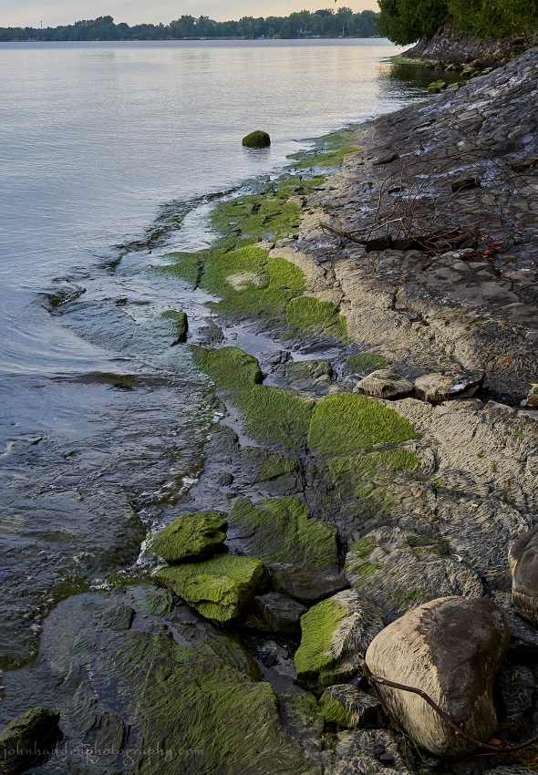
About Today’s Photo:
With the lake water levels receding, the line of bright green algae is emerging from the water. I don’t have an ID on what species of algae this is (if you know, please educate me!), but it seems to be a pretty normal phenomena here along the shoreline. In past summers I’ve noted that it turns brownish tan (as it’s beginning to do in the photo) and seems to enter a dormancy period. Once it’s submerged again, it comes back to life sporting its bright green coloration. It’s pretty darn slippery!
Sony A7II, Sony 24-240mm lens @ 37mm, ISO 1250, f/13, 1/80″ exposure.
Friday, September 8, 2023

 The leading edge of last evening’s storms approaches…
Morning Observation:
This morning in North Hero at 7:30AM it’s currently 70 degrees under mostly cloudy skies. Winds are out of the south at 5-8 mph. Relative humidity is 92%, dewpoint 69, barometric pressure 29.83”. We picked up 0.74” of rain yesterday. Yesterday’s high was 82, and yesterday’s low was 70. The overnight low got down to 70.
This morning in Huntington it’s currently 67 degrees under mostly cloudy skies. Winds are calm. Relative humidity is 95%, dewpoint 65, barometric pressure 29.88”. We picked up 0.80” of rain yesterday. Yesterday’s high was 89, and yesterday’s low was 65. The overnight low got down to 65.
Forecast Discussion:
Unsettled conditions will generally be the rule for today and through the upcoming weekend. Low pressure centered over northern Québec this morning will swing a weak trough across the region today setting off some afternoon showers and thunderstorms. These storms are not expected to be as severe as yesterday’s, with the most likely locations for stronger storms being over southern Vermont this afternoon. A cold front will move through later this afternoon into the evening and is expected to stall over the region on Saturday in roughly a northeast to southwest orientation. Shortwave energy is expected to track along this frontal boundary during the day on Saturday kicking off some more showers and afternoon thunderstorms, mostly over southern Vermont. After a quiet Saturday night, showers and thunderstorms are expected to redevelop on Sunday as another wave of shortwave energy moves through. Showers will persist into Monday before we get some dry conditions moving in for Tuesday.
3-Day Forecast:
We’ll see mostly cloudy skies today with a 40% chance of showers and thunderstorms, mainly this afternoon. Highs will be near 82 with south winds 8-13 mph. Rainfall amounts of less than 0.10″ are possible with higher amounts possible in thunderstorms. Tonight should be mostly cloudy with a 30% chance of showers. Lows will be around 61 with northwest winds 5-8 mph. Rainfall amounts between 0.25″-0.50″ are possible.
Saturday should be mostly cloudy with a 40% chance of showers in the afternoon. Highs will be near 75 with northwest winds 5-7 mph. Rainfall amounts of less than 0.10″ are possible. Saturday night should be mostly cloudy with a 30% chance of showers before midnight. Lows will be around 62 with light north winds. Rainfall amounts of less than 0.10″ are possible.
Sunday should be mostly cloudy with showers likely, mainly after 2:00PM. Highs will be near 74 with north winds 3-5 mph. Chance of precipitation is 60% with rainfall amounts between 0.10″-0.25″ possible. Sunday night should be mostly cloudy with showers. Lows will be around 62 with north winds 3-5 mph. Chance of precipitation is 80% with rainfall amounts between 0.25″-0.50″ possible.
Almanac:
Last year on this date in Huntington we had a high of 78 and a low of 53.
Last year in North Hero we had a high of 75 and a low of 61.
Burlington averages for this date are a low of 56 and a high of 76.
The record low was 37 in 1978.
The record high was 94 in 1945.
The Lake Champlain lake level in Burlington is 97.60′.
The water temperature is 76˚.
Last year’s lake level was at 94.23′.
Sky Notes:
Sunrise: 6:22AM
Sunset: 7:15PM
Length of day: 12:53:11
Today will be 2:59 shorter than yesterday.
The Moon is a waning crescent, 23.4 days old with 36% illumination.
No Moonrise
Moonset: 4:26PM
About Today’s Photo:
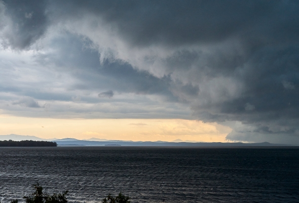
We watched spellbound yesterday afternoon as a massive storm system made its way across the lake from the west. You can clearly see Mt. Mansfield on the left side of the image with Camel’s Hump near the center—both still in the clear. We were treated to a continuing pyrotechnic display most of the night last night with bolts of lightning spidering across the sky over the spine of the Green Mountains and beyond to the east and south. Quite the show!
Sony A7II, Sony 24-240mm lens @ 45mm, ISO 800, f/13, 1/125″ exposure.
Thursday, September 7, 2023

 A cormorant tree in Carry Bay
Morning Observation:
This morning in North Hero at 7:10AM it’s currently 74 degrees under partly cloudy skies. Winds are out of the south at 7-9 mph. Relative humidity is 94%, dewpoint 72, barometric pressure 29.71”. Yesterday’s high was 85, and yesterday’s low was 73. The overnight low got down to 74.
This morning in Huntington it’s currently 66 degrees under partly cloudy skies. Winds are calm. Relative humidity is 98%, dewpoint 65, barometric pressure 29.76”. Yesterday’s high was 90, and yesterday’s low was 63. The overnight low got down to 65.
The Heat Advisory remains in effect for our region until 7:00PM tonight.
Forecast Discussion:
After a dry and once again hot’n’muggy start to the day today, clouds will be on the increase as a slow moving disorganized trough and attendant frontal boundary approach from the Great Lakes this afternoon. Showers and thunderstorms are expected to push into the region by this afternoon with some storms capable of strong winds and heavy downpours. Storms should wind down by evening as diurnal heating shuts down, but showers are expected continue overnight on gusty south winds. Unsettled conditions will continue into Saturday as the aforementioned frontal boundary becomes quasi-stationary over the region with showers and thunderstorms expected to redevelop in the afternoon. Some storms may produce gusty winds and brief downpours. Showers will persist into Saturday night with a renewed chance of showers on Sunday into Monday as a trough lifts northward out of the Tennessee River valley into the Northeast. Unsettled but seasonable conditions are expected heading into the middle of next week.
3-Day Forecast:
We’ll see increasing clouds today with showers and thunderstorms likely, mainly after 3:00PM. Some of the storms could produce gusty winds and heavy rain. Highs will be near 90 with south winds 5-8 mph in Huntington and 10-13 mph over Lake Champlain. Chance of precipitation is 60% with rainfall amounts between 0.25″-0.50″ possible. Tonight should be mostly cloudy with showers and thunderstorms. Lows will be around 67 with south winds 7-14 mph. Chance of precipitation is 60% with rainfall amounts between 0.25″-0.50″ possible.
Friday should be mostly cloudy with a 40% chance of showers, with thunderstorms possible in the afternoon. Highs will be near 81 with south winds 6-10 mph. New rainfall amounts of less than 0.10″ are possible with higher amounts possible in thunderstorms. Friday night should be mostly cloudy with a 50% chance of showers. Lows will be around 67 with southwest winds 5-7 mph. Rainfall amounts between 0.10″-0.25″ are possible.
Saturday should be mostly cloudy with a 50% chance of showers. Highs will be near 78 with north winds 3-6 mph. Rainfall amounts between 0.10″-0.25″ are possible. Saturday night should be mostly cloudy with showers likely. Lows will be around 62 with north winds 3-6 mph. Chance of precipitation is 60% with rainfall amounts of less than 0.10″ possible.
Almanac:
Last year on this date in Huntington we had a high of 77 and a low of 53.
Last year in North Hero we had a high of 78 and a low of 63.
Burlington averages for this date are a low of 56 and a high of 76.
The record low was 36 in 1962.
The record high was 94 in 2015 (we had a high of 89 in Huntington). Burlington set a new record high yesterday of 92˚.
The Lake Champlain lake level in Burlington is 97.56′.
The water temperature is 72˚.
Last year’s lake level was at 94.25′.
Sky Notes:
Sunrise: 6:21AM
Sunset: 7:17PM
Length of day: 12:56:10
Today will be 2:59 shorter than yesterday.
The Moon is a waning crescent, 22.5 days old with 46% illumination.
Moonrise: 11:35PM
Moonset: 3:30PM
About Today’s Photo:
We spent a good part of yesterday’s hot’n’muggy day out on our boat with friends. Part of our journey took us through the cut in the old Island Railway line between the Broad Lake and Carry Bay here in North Hero. It seems that the cormorants have taken a liking to several of the trees along the old rail bed. There were several in this particular tree that had been coated with cormorant poop through the season. We noted that the birds were all panting in the branches with their bills open and their throats pulsating. Unlike most aquatic birds, cormorants lack the water repellant oil coating of their duck cousins, so they need to periodically dry out in the sun. You’ll often see them perched with their winds extended to dry.
iPhone 12 Pro
Wednesday, September 6, 2023

 Virginia creeper creeping up a cherry tree
Morning Observation:
This morning in North Hero at 7:15AM it’s currently 73 degrees under mostly clear skies. Winds are out of the south at 2-4 mph. Relative humidity is 95%, dewpoint 71, barometric pressure 29.86”. Yesterday’s high was 86, and yesterday’s low was 71. The overnight low got down to 73.
This morning in Huntington it’s currently 64 degrees under mostly clear skies. Winds are calm. Relative humidity is 98%, dewpoint 64, barometric pressure 29.90”. Yesterday’s high was 89, and yesterday’s low was 62. The overnight low got down to 63.
There is a Heat Advisory in effect for our region until 7:00PM Thursday.
Forecast Discussion:
We’ve got another hot’n’humid day on tap for today courtesy of a high pressure heat ridge cresting over the region. Highs today should be just about on par with yesterday—in the upper 80s to low 90s—with dewpoints in the upper 60s to mid 70s. The heat ridge is expected to move to our east overnight tonight as a slow moving trough of low pressure approaches from the Great Lakes. After a hot’n’humid start to the day on Thursday, showers and thunderstorms are expected to move into the region by Thursday afternoon with the chance of some severe storms developing over northern regions in the afternoon. Showers and thunderstorms will redevelop during the day on Friday. Some storms may contain heavy downpours. Unsettled conditions are expected heading into the weekend as temperatures moderate back to more seasonable levels. At this point it looks like we’ll see some pleasant early fall conditions through much of next week.
3-Day Forecast:
We’ll see sunny skies today with a high near 87 and south winds around 5 mph. Tonight should be mostly clear with a low around 70 and south winds 5-8 mph.
Thursday should bring increasing clouds with scattered showers and thunderstorms in the afternoon. Some of the storms could produce gusty winds and heavy rain. Highs will be near 87 with south winds 8-10 mph. Chance of precipitation is 50% with rainfall amounts between 0.25″-0.50″ with higher amounts possible in thunderstorms. Thursday night should be mostly cloudy with scattered showers and thunderstorms. Lows will be around 68 with south winds 7-13 mph. Chance of precipitation is 50% with rainfall amounts between 0.10″-0.25″ with higher amounts possible in thunderstorms.
Friday should be mostly cloudy with showers and afternoon thunderstorm. Highs will be near 85 with south winds 7-11 mph. Chance of precipitation is 70% with rainfall amounts between 0.10″-0.25″ with higher amounts possible in thunderstorms. Friday night should be mostly cloudy with a50% chance of showers and thunderstorms. Lows will be around 67 with south winds 5-7 mph becoming light and variable in the evening. Rainfall amounts between 0.10″-0.25″ are possible with higher amounts possible in thunderstorms.
Almanac:
Last year on this date in Huntington we had a high of 65 and a low of 59. We picked up 0.42″ of rain.
Last year in North Hero we had a high of 69 and a low of 59.
Burlington averages for this date are a low of 56 and a high of 77.
The record low was 36 in 1942.
The record high was 90 in 2015 (we had a high of 87 in Huntington).
The Lake Champlain lake level in Burlington is 97.65′.
The water temperature is 72˚.
Last year’s lake level was at 94.29′.
Sky Notes:
Sunrise: 6:20AM
Sunset: 7:19PM
Length of day: 12:59:09
Today will be 2:58 shorter than yesterday.
The Moon is in its last quarter, 21.5 days old with 56% illumination.
Moonrise: 10:49PM
Moonset: 2:25PM
About Today’s Photo:
Virginia creeper is a member of the grape family and is native to North America. This close-up look shows the adhesive climbing roots attached to the bark a of a cherry tree. The plant produces small black berries that are toxic to humans, but offer a valuable winter food source for many bird species.
iPhone 12 Pro
Tuesday, September 5, 2023

 Turkey tail fungi at the Tracy Wood nature area
Morning Observation:
This morning in North Hero at 7:10AM it’s currently 71 degrees under mostly clear skies. There’s quite a bit of fog to our south and east. Winds are calm. Relative humidity is 96%, dewpoint 70, barometric pressure 29.92”. Yesterday’s high was 81, and yesterday’s low was 69. The overnight low got down to 71.
This morning in Huntington it’s currently 62 degrees under partly cloudy skies. Winds are calm. Relative humidity is 97%, dewpoint 62, barometric pressure 29.96”. Yesterday’s high was 89, and yesterday’s low was 58. The overnight low got down to 62.
Heat Advisories are in effect for our region from 1:00PM today until 7:00PM Thursday.
Forecast Discussion:
Hot’n’muggy. Them’s the words of the day, or next several days actually. A heat ridge is currently building into the region and will bump temperatures into the upper 80s and low 90s today, Wednesday, and Thursday. Dewpoints are expected to push into the upper 60s and low 70s, and with little wind to speak of and plenty of sunshine, heat index values are expected to reach into the mid to upper 90s. So, we go from complaining about the rain to complaining about the heat (well I do anyway…) There’s an outside chance of some convective showers Wednesday afternoon over northern mountains. Better relief looks to come sometime Thursday as south winds pick up and the disorganized pieces of a weak trough move through the region bringing shower and thunderstorms Thursday afternoon/evening. With a blocking low developing offshore to our east, unsettled conditions are expected to remain through much of the upcoming weekend as conditions get stuck over the northeast. So the weekend at this point is looking showery but cooler. Dry and more seasonable conditions are expected to return by early next week.
3-Day Forecast:
We’ll see sunny skies today with a high near 89 and calm wind becoming northerly around 5 mph in the afternoon. Tonight should bring increasing clouds with a low around 70 and light and variable winds.
Wednesday should be mostly sunny with a high near 88 and light and variable winds. Wednesday night should be partly cloudy with a low around 70 and south winds 3-7 mph.
Thursday should be partly sunny with a 30% chance of afternoon showers. Highs will be near 88 with south winds 5-9 mph. Rainfall amounts of less than 0.10″ are possible. Thursday night should be mostly cloudy with a 40% chance of showers. Lows will be around 70 with southeast winds 3-8 mph. Rainfall amounts of less than 0.10″ are possible.
Almanac:
Last year on this date in Huntington we had a high of 62 and low of 56. We picked up 0.46″ of rain.
Last year in North Hero we had a high of 62 and a low of 55. We picked up 0.01″ of rain.
Burlington averages for this date are a low of 57 and a high of 77.
The record low was 37 in 1963.
The record high was 93 in 2018 (we had a high of 91 in Huntington).
The Lake Champlain lake level in Burlington is 97.73′.
The water temperature is 71˚.
Last year’s lake level was at 94.28′.
Sky Notes:
Sunrise: 6:19AM
Sunset: 7:21PM
Length of day: 13:02:07
Today will be 2:58 shorter than yesterday.
The Moon is waning gibbous, 20.5 days old with 66% illumination.
Moonrise: 10:12PM
Moonset: 1:14PM
About Today’s Photo:
Robin snapped this lovely photo of some turkey tail fungi on a log in the Tracy Woods nature area in South Hero. The latin name of this fungi—Polyporus versicolor—speaks to the variety of colors that it often display, similar to the tail of a turkey!
iPhone SE
