Sunday, December 31, 2017

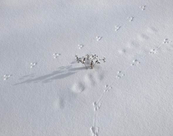
A pair of mouse tracks bracket a dried aster
Morning Observation:
This morning in Huntington at 8:40AM it’s currently -5 degrees and snizzling lightly under partly cloudy skies. Winds are calm. Relative humidity is 80%, dewpoint -10, barometric pressure 30.24” and rising. We picked up 0.30” of snow in the past 24hrs and have 8” at that stake. Yesterday’s high was was a blistering 11, and the overnight low was -6.
Forecast:
After a brief respite yesterday we’ll be treated to another reinforcing shot of Arctic air today which will keep daytime highs in the single digits around zero today and into the middle of next week. Windchills will also be a concern as a breezy northwest wind picks up later today. Be sure to bundle up for your New Years activities tonight! The next chance for a moderation in temperatures will come Tuesday into Wednesday as a clipper system moves through the region bringing temperatures in the teens and a bit of snow. Cold will return, however, on Friday and into next weekend.
We’ll see mostly cloudy skies today with highs near 0F and NW winds at 10 to 15 mph. Tonight should be mostly cloudy with lows around -10F and NW winds at 5 to 10 mph.
Monday—New Years Day—should be partly to mostly cloudy with highs around 0F and NW winds at 5 to 10 mph. Monday night should be partly cloudy with lows around -11F and light and variable winds.
Tuesday’s looking mostly cloudy and a bit “milder” with highs around 10F and SW winds at 5 to 10 mph. Tuesday night should be overcast with lows around 9F and SSW winds at 5 to 10 mph.
Almanac:
Last year on this date we had a high of 35 and a low of 9. We had 2″ of snow at the stake.
Burlington averages for this date are highs of 29 and lows of 13.
The record high was 56°F in 1965.
The record low was -19°F in 1963.
Sky Notes:
Sunrise: 7:29AM
Sunset: 4:23PM
Length of Visible Light: 10h 0m
Length of Day: 8h 54m
Tomorrow will be 0 minutes 47 seconds longer
The Moon is waxing gibbous, 12.7 days old with 95% illumination.
Moonrise: 3:20PM
Moonset: 5:29AM
About Today’s Photo:
Fresh snow offers up all kinds of stories to those keeping their eyes open. I came across this set up mouse tracks while skiing at Camels Hump Nordic yesterday. I’m pretty sure it was just one individual coming and going. You can see the tail impression clearly on the lower set of tracks. There’s also an older set of tracks beneath the fresh snow between the fresh set. Despsite the cold, it’s busy up there in the woods!
iPhone 6S
Saturday, December 30, 2017


A chilly looking Camel’s Hump summit emerges from light clouds
Morning Observation:
This morning in Huntington at 8:00AM it’s currently -7 degrees under mostly cloudy skies. Winds are calm. Relative humidity is 84%, dewpoint -11, barometric pressure 30.13” and falling slowly. We picked up 0.60” of new snow in the past 24hrs and have 7.5” at the stake. Yesterday’s high was 1, and the overnight low was -14.
Forecast:
An upper level trough of low pressure will move into the region today bringing clouds and light snow this morning in the ‘Dacks and this afternoon in the Greens before gradually tapering off tonight. We’ll also enjoy a brief respite from the single digits as temperatures rise into the low teens today. Heat wave! Another surge of Arctic air moves into the region on northwest winds tonight and Sunday bringing very cold wind chill temperatures later tonight through Sunday afternoon. Winds will taper off Sunday night but very cold temperatures will
persist to start the New Year with another brief “warm up” on Wednesday and Thursday. Longer term forecasts call for a return of Arctic cold going into next weekend.
We’ll see generally cloudy skies today with a few flurries or snow showers possible. Highs will be around 11F with light and variable winds. Tonight should be cloudy with snow showers mainly during the evening. Lows will be around -6F with light and variable winds. Chance of snow is 50% with snow accumulations of a dusting to 2″.
Sunday should be cloudy with highs around -1F and NW winds at 5 to 10 mph. Sunday night should be cloudy with lows around -12F and NW winds at 5 to 10 mph.
New Years Day should be mostly cloudy with highs near 0F and NNW winds at 5 to 10 mph. Monday night should be partly cloudy with lows around -13F and light and variable winds.
Almanac:
Last year on this date we had a high of 32 and a low of 18. We picked up 0.50″ of new snow and had 3″ at the stake.
Burlington averages for this date are highs of 29 and lows of 13.
The record high was 51°F in 1990.
The record low was -29°F in 1933.
Sky Notes:
Sunrise: 7:28AM
Sunset: 4:22PM
Length of Visible Light: 10h 0m
Length of Day: 8h 53m
Tomorrow will be 0 minutes 43 seconds longer
The Moon is waxing gibbous, 11.6 days old with 89% illumination.
Moonrise: 2:30PM
Moonset: 4:15AM
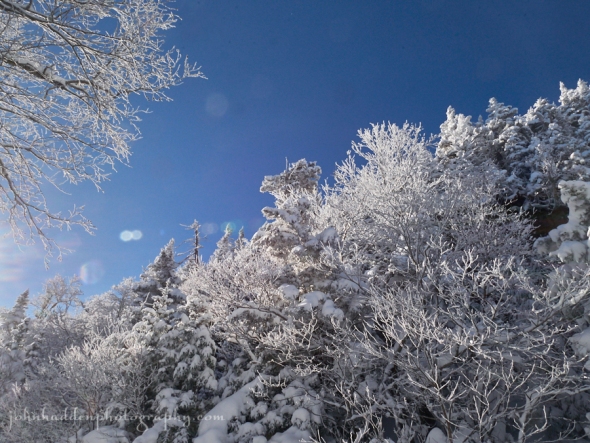
About Today’s Photo:
Light clouds skirt the summit of Camel’s Hump in late afternoon light. Must be cold up there!
Panasonic GX8, Lumix 100-300mm lens @ 177mm, ISO 400, f/16, 1/640″ exposure.
Friday, December 29, 2017

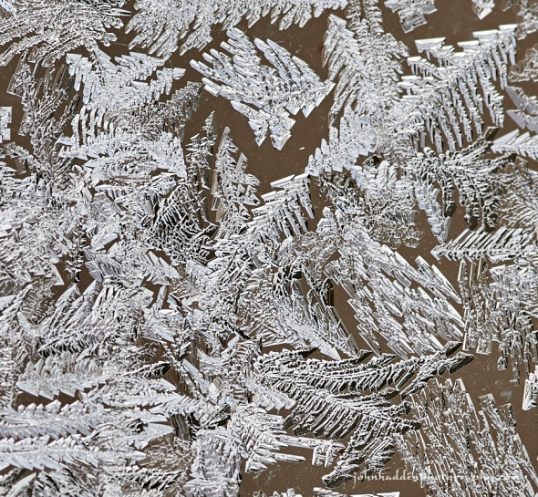
A close look at frost crystals forming on the inside of our garage windows
Morning Observation:
This morning in Huntington at 8:15AM it’s currently -5 degrees under cloudy skies. Winds are calm. Relative humidity is 84%, dewpoint -8, barometric pressure 30.32” and dropping slowly. We have 7” of snow at the stake. Yesterday’s high was 1, and the overnight low got down to -15. Brrrr!
Forecast:
Arctic high pressure will deliver another in a long string of fridgid days today. Temperatures should be a a degree or two warmer today—in the mid single digits—but winds should be light so wind chill will be less of a concern. Saturday should see temperatures moderate into the low teens before a reinforcing blast of Arctic air returns Sunday dropping the mercury back to around zero for daytime highs on Sunday and Monday. Temperatures should begin to moderate a bit by the middle of next week. Stay warm!
We’ll see cloudy skies with a few snow showers this afternoon. Highs will be around 2F with light and variable winds. Chance of snow is 30%. Tonight should be cloudy with lows around -6F and light and variable winds.
Saturday should be mostly cloudy with highs around 11F and light and variable winds. Saturday night should be cloudy with lows around -6F and light and variable winds.
Sunday’s looking overcast with highs around -1F and NW winds at 10 to 15 mph. Sunday night should be cloudy with lows around -11F and NW winds at 5 to 10 mph.
Almanac:
Last year on this date we had a high of 32 and a low of 24. We picked up 2.75″ of new snow and had 3″ at the stake.
Burlington averages for this date are highs of 29 and lows of 13.
The record high was 58°F in 1984.
The record low was -29°F in 1933.
Sky Notes:
Sunrise: 7:28AM
Sunset: 4:21PM
Length of Visible Light: 9h 59m
Length of Day: 8h 53m
Tomorrow will be 0 minutes 38 seconds longer
The Moon is waxing gibbous, 10.5 days old with 80% illumination.
Moonrise: 1:49PM
Moonset: 3:02AM
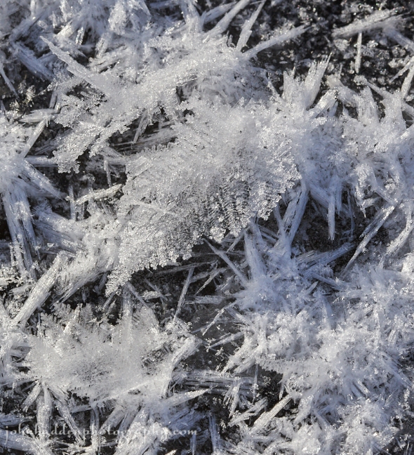
About Today’s Photo:
Cold temperatures have some advantages not the least of which is the formation of wonderful ice crystals on the inside of our garage windows. This shot shows maybe a square inch of frost, and you can really get a sense of the amazing structure of the crystals.
Nikon D600, Sigma 105mm macro lens, ISO 320, f/9, 1/640″ exposure.
Thursday, December 28, 2017

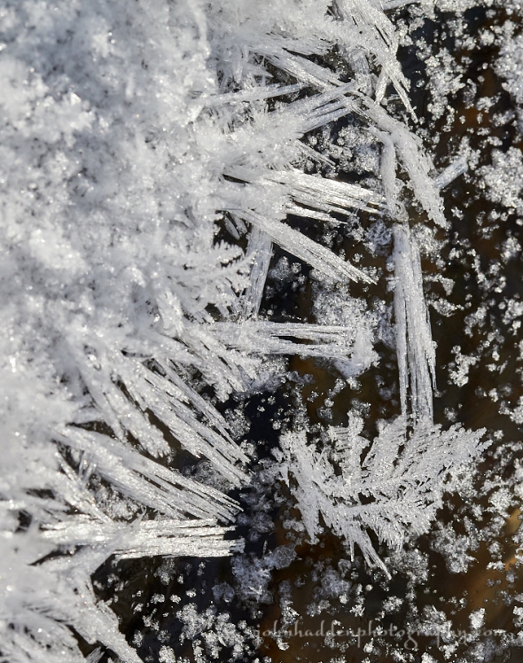
Hoar frost crystals on Fargo Brook
Morning Observation:
This morning in Huntington at 8:20AM it’s currently -9 degrees under clear skies. Winds are calm. Relative humidity is 81%, dewpoint -14, barometric pressure 30.51” and steady. We picked up 0.25” of new snow in the past 24hrs and have 7” at the stake. Yesterday’s high was 9, and the overnight low got down to -12.
A Wind chill warning remains in effect until 7:00AM EST Friday.
Forecast:
Arctic high pressure over much of Canada and the US will keep us in the deep freeze straight through to early next week. Wind chill will reach dangerous levels today—25 below to 40 below—courtesy of continued northwest winds. Be sure to cover up exposed skin if you need to be outside for any extended length of time!
We’ll see partly cloudy skies today with bitter cold temperatures with highs only around -2F and NW winds at 10 to 15 mph. Tonight should be mostly cloudy with lows around -9F locally and -20 in colder pocket of the ‘Dacks and NEK. Winds will be out of the NNW at 5 to 10 mph.
Friday should be overcast and cold with highs around 3F and light and variable winds. Friday night should be mostly cloudy with lows around -8F and light and variable winds.
Saturday’s looking cloudy with highs around 7F and light and variable winds. Saturday night should be cloudy with lows around -8F and light and variable winds.
Almanac:
Last year on this date we had a high of 32 and a low of 21. We had 1.5″ of snow at the stake.
Burlington averages for this date are highs of 29 and lows of 13.
The record high was 57°F in 1982.
The record low was -16°F in 1933.
Sky Notes:
Sunrise: 7:28AM
Sunset: 4:21PM
Length of Visible Light: 9h 59m
Length of Day: 8h 52m
Tomorrow will be 0 minutes 33 seconds longer
The Moon is waxing gibbous, 9.4 days old with 71% illumination.
Moonrise: 1:13PM
Moonset: 1:50AM
About Today’s Photo:
A chilly photo for a chilly morning. Hoar frost crystals form near open water on Fargo Brook.
Nikon D600, Sigma 105mm macro lens, IOS 800, f/14, 1/400″ exposure.
Wednesday, December 27, 2017

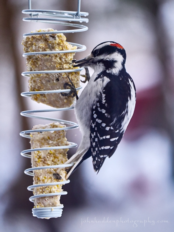
A hairy woodpecker feasts on suet
Morning Observation:
This morning in Huntington at 8:00AM it’s currently -7 degrees under partly cloudy skies. Winds are calm. Relative humidity is 85%, dewpoint -10, barometric pressure 30.45” and steady. We picked up 0.30” of new snow in a brief flurry around 7:30PM last night. We have 7” at the stake. Yesterday’s high was 20, and the overnight low got down to -10.
There’s a Wind chill warning in effect from 7:00PM this evening to 7:00AM EST Friday.
Forecast:
Arctic high pressure will continue to pour fridgid air into the region from Canada today, with highs only in the single digits north to low teens in the southern valleys. Wind chill values will dip to -15 to -25 this morning, and will reach more dangerous levels of -25 to -40 tonight through Thursday night on continued northwesterly winds. Both daytime highs and overnight lows will be 20 degrees below normal through Monday of next week. While a few flurries are possible at times over this perious, no major precipitation systems are forecast over the next 5 to 7 days. Stay warm!
We’ll see partly cloudy skies today with highs only around 7F and WNW at 10 to 15 mph. Tonight should be partly cloudy with lows near -10F and WNW winds at 5 to 10 mph.
Thursday will be bitterly cold and cloudy with daytime highs of only -2F and NW winds at 10 to 15 mph. Thursday night should be cloudy with lows around -8F and to -20 in cold pockets in the ‘Dacks and NEK. Winds should be light and variable.
Friday’s looking overcast with highs around 4F and light and variable winds. Friday night should be cloudy with lows around -8F and light and variable winds.
Almanac:
Last year on this date we had a high of 48 and a low of 32. We had 1.5″ of snow at the stake.
Burlington averages for this date are highs of 30 and lows of 14.
The record high was 55°F in 1949.
The record low was -23°F in 1968.
Sky Notes:
Sunrise: 7:28AM
Sunset: 4:20PM
Length of Visible Light: 9h 58m
Length of Day: 8h 51m
Tomorrow will be 0 minutes 29 seconds longer
The Moon is waxing gibbous, 8.4 days old with 60% illumination.
Moonrise: 12:41PM
Moonset: 12:41AM
About Today’s Photo:
We have two species of woodpecker that overwinter in our region and that you might see at your bird feeders—the downy, and the hairy. This is a male hairy woodpecker. The hairy looks a lot like the downy with the males sporting a red spot on their head. Hairys are about 20% larger, however, and their bills are noticeably longer. My mnemonic device for remembering the difference is: “hairys are huge and downys are dinky.” The much larger pileated woodpecker also overwinters in the region, but you won’t find them at your feeders as they’re off in the woods drilling large square holes in dead trees searching for insects. You might here their distinctive call though!
Panasonic GX8, Lumix 100-300mm lens @ 240mm, ISO 800, f/5.6, 1/800″ exposure.
Tuesday, December 26, 2017


A curiously tawny red squirrel
Morning Observation:
This morning in Huntington at 8:00AM it’s currently 14 degrees under partly cloudy skies. Winds are out of the west at 4-7 mph. Relative humidity is 64%, dewpoint 3, barometric pressure 30.16” and rising. We have 7” of snow at the stake. Yesterday’s high was 32, and the overnight low was 12.
Forecast:
A cold front across the Ottawa Valley this morning will provide a shot of arctic air to the region later today into tonight while bringing scattered snow showers this afternoon, especially across the northern Adirondacks and central Vermont. Wind chill values will dip to -15 to -25 below by daybreak on Wednesday, and will reach more dangerous levels Wednesday night and Thursday on continued northwesterly winds. Both high and low temperatures will be 20 degrees below normal by mid week. The next chance of snow arrives next weekend.
We’ll see partly cloudy skies today with a few flurries or snow showers possible this afternoon. Highs will be around 16F with WNW winds at 10 to 15 mph. Tonight should be partly to mostly cloudy. Lows will be around -4F with light and variable winds.
Wednesday should be partly cloudy and cold with highs only around 7F and WNW winds at 10 to 15 mph. Wednesday night should be partly cloudy and cold with lows around -11F and WNW winds at 5 to 10 mph.
Thursday’s looking bitterly cold and loudy with daytime highs around -2F and NW winds at 10 to 15 mph. Thursday night should be overcast with lows around -8F and light and variable winds.
Almanac:
Last year on this date we had a high of 44 and low of 8. We had 4″ of snow at the stake.
Burlington averages for this date are highs of 30 and lows of 14.
The record high was 58°F in 1982.
The record low was -26°F in 1980.
Sky Notes:
Sunrise: 7:28AM
Sunset: 4:19PM
Length of Visible Light: 9h 58m
Length of Day: 8h 51m
Tomorrow will be 0 minutes 24 seconds longer
The moon is in its first quarter, 7.4 days old with 50% illumination.
Moonrise: 12:12PM
No Moonset
About Today’s Photo:
This curiously tawny red squirrel has been hanging around our bird feeders this season. There might actually be two… Red squirrels go through a fall molt when their coats become the familiar reddish brown, however, this little critter seemed to miss that appointment. My best guess is that it’s a juvinile that was born late in the summer (red squirrels can have two litters if food sources are good which this year they are…) and hasn’t quite caught up to things color-wise.
Panasonic GX8, Lumix 100-300mm lens @ 300mm, ISO 800, f/5.6, 1/1300″ exposure.
Monday, December 25, 2017: Christmas Day

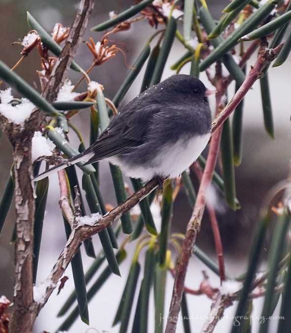
A male junco pauses briefly in the rhododendrons near our feeders
Merry Christmas!
Morning Observation:
This morning in Huntington at 8:30AM it’s currently 23 degrees and snow lightly under overcast skies. Winds are calm. Relative humidity is 93%, dewpoint 21, barometric pressure 29.63” and falling rapidly. We’ve picked up 2” of new snow and have 8” at the stake. Yesterday’s high was 28, and the overnight low was 18.
A Winter Storm Warning remains in effect until 4:00PM EST this afternoon.
Forecast:
Low pressure across western New York state early this morning will redevelop across Cape Cod and the Gulf of Maine later this morning. This system will bring 4″ to 8″ of snowfall to the region with the lesser amounts west of the Greens and higher amounts east. Areas of blowing snow will develop this afternoon as winds become gusty from the west. Arctic air will filter into the region on Tuesday with northwesterly winds and well below normal temperatures through the end of the week. Wednesday night into Thursday should bring the coldest air of the season so far with temperatures dropping into the teens below zero along with significant windchills.
Snow will taper off and end this morning but skies will remain cloudy this afternoon as a westerly wind kicks in. Highs will be around 28F with south winds shifting to west at 10 to 20 mph this afternoon. Chance of snow is 90% with snow accumulations of 2″ to 4″. Tonight should be partly cloudy with occasional snow showers overnight. Lows will be around 11F with WSW winds at 10 to 20 mph. Chance of snow is 40%.
Tuesday should bring a mix of clouds and sun early, then becoming cloudy later in the day with a few flurries or snow showers possible. Highs will be around 14F with west winds at 10 to 15 mph. Tuesday night should be mostly clear with lows around -6F and WNW winds at 5 to 10 mph.
Wednesday should be generally sunny with highs only around 5F and WNW winds at 10 to 15 mph. Wednesday night should be clear and cold with lows around -12F and NW winds at 5 to 10 mph.
Almanac:
Last year on this date we had a high of 37 and a low of 8. We picked up 0.08″ of rain and had 4″ of snow at the stake.
Burlington averages for this date are highs of 30 and lows of 15.
The record high was 62°F in 1964.
The record low was -25°F in 1980.
Sky Notes:
Sunrise: 7:27AM
Sunset: 4:19PM
Length of Visible Light: 9h 57m
Length of Day: 8h 51m
Tomorrow will be 0 minutes 19 seconds longer
The Moon is a waxing crescent, 6.4 days old with 40% illumination.
Moonrise: 11:44AM
Moonset: 11:36PM
About Today’s Photo:
We have quite the bumper crop of juncos this season. I’d count a good two dozen bopping around in the shrubs near the house by the feeders. Though these little birds might appear drab, they have a certain “restrained elegance” I think. Like their sporting little tuxedos…
Panasonic GX8, Lumix 100-300mm lens @ 280mm, ISO 400, f/7.1, 1/1300″ exposure.
Sunday, December 24, 2017

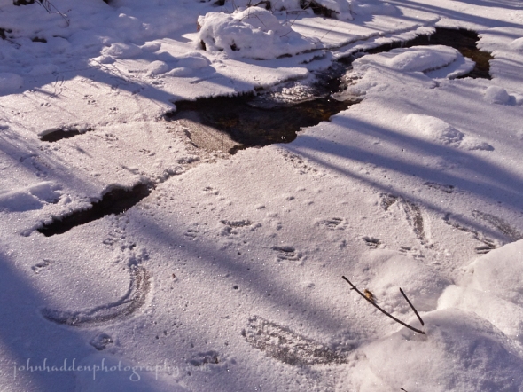
Fresh snow on the ice of Fargo Brook tells as story…
Morning Observation:
This morning in Huntington at 7:55AM it’s currently 23 degrees under cloudy skies. Winds are calm. Relative humidity is 94%, dewpoint 22, barometric pressure 30.21” and rising rapidly. We picked up 0.52” of rain and 0.50” of new snow, and have 6” of lumpy snow at the stake. Yesterday’s high was 38, and the overnight low was 23.
A Winter Storm Warning in effect from midnight tonight to 4:00PM EST Monday.
Forecast:
High pressure across the Great Lakes region will shift eastward and crest over the region today bringing cold and dry conditions today with light north to northwest winds. A developing area of low pressure across the upper Ohio River
Valley tonight will move northeastward and redevelop across the Gulf of Maine on Christmas Day. This system will bring widespread snow to the region during the pre-dawn hours, with the steadiest snowfall expected during Christmas morning. By afternoon, we should see 5″ to 8″ of snowfall across the region! Nice Christmas present for us skiers! An extended period of arctic air is then expected for the remainder of the week.
We’ll see cloudy skies today with a few flurries possible. Highs will be around 26F with north winds at 5 to 10 mph. Tonight should be cloudy with snow developing after midnight. Lows will be around 18F with ESE winds at 10 to 15 mph. Chance of snow is 90% with snow accumulations of 1″ to 3″ overnight.
Christmas Day will bring snow during the morning, giving way to lingering snow showers during the afternoon. Highs will be around 24F with SE winds shifting to the west at 10 to 20 mph. Chance of snow is 100% with snow accumulations of 3″ to 5″. Monday night should be cloudy with a few lingering flurries or snow showers possible. Lows will be around 12F with WSW winds at 10 to 15 mph.
Tuesday’s looking mostly cloudy with a few flurries or snow showers possible. Highs will be around 18F with west winds at 10 to 15 mph. Tuesday night should be partly cloudy with lows around -4F and light and variable winds.
Almanac:
Last year on this date we had a high of 42 and a low of 33. We had 5.5″ of snow at the stake.
Burlington averages for this date are highs of 30 and lows of 15.
The record high was 68°F in 2015 (we had a high of 66).
The record low was -18°F in 1989.
Sky Notes:
Sunrise: 7:27AM
Sunset: 4:18PM
Length of Visible Light: 9h 57m
Length of Day: 8h 50m
Tomorrow will be 0 minutes 15 seconds longer
The Moon is a waxing crescent, 5.5 days old with 30% illumination.
Moonrise: 11:16AM
Moonset: 10:32PM
About Today’s Photo:
A little fresh snow on the ice of Fargo Brook tells the story of several creatures passing by. Red squirrel tracks are evident here and there, but the most interesting tracks are those of the white tailed deer that came to drink at the open water and found the ice a tad slippery. Their skidding hoof marks are clear to see!
Panasonic GX8, Lumix 14-140mm lens @ 17mm, ISO 800, f/16, 1/1000″ exposure.
Saturday, December 23, 2017

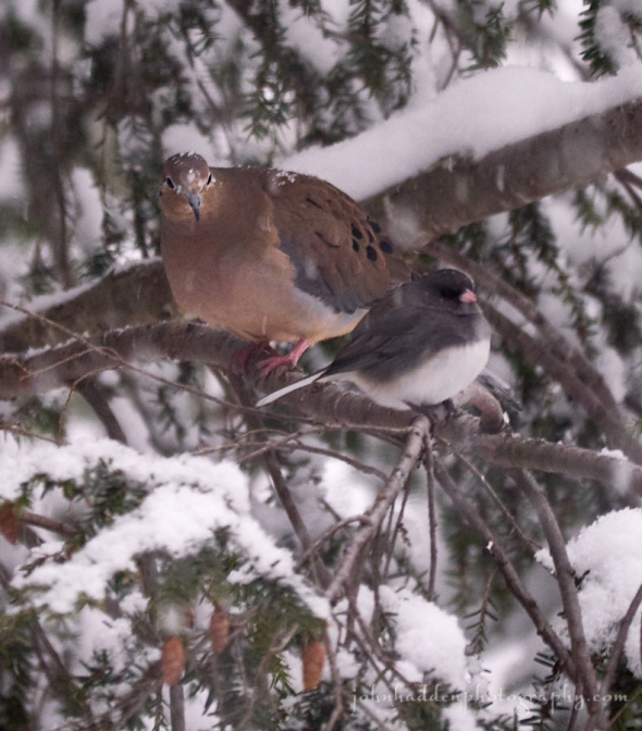
A mourning dove an junco share a branch in our hemlock tree
Morning Observation:
This morning in Huntington at 7:40AM it’s currently 29 degrees under overcast skies. Winds are calm. Relative humidity is 95%, dewpoint 28. We picked up 8.25” of snow in the past 24hrs and 0.25” of frozen rain/snow mix on top of that early this morning. Yesterday’s high was 25, and the overnight low was 22.
A Winter Weather Advisory in effect until 10:00PM EST this evening (the Winter Weather Warning has been cancelled).
Forecast:
Active weather will continue through Christmas Day across the region. Mixed precipitation will lift northward this morning and transition to mostly rain by midday with freezing rain mixing in across southern and eastern Vermont. Rain will transition back to snow around nighfall with accumulations of a dusting to a couple inches. Sunday will be fairly quiet before another low pressure moving out the Ohio River valley combinds with a coastal low to bring widespread snow for the Christmas holiday. We may see several inches of snow out of that storm. Colder arctic air and drier conditions are expected for the remainder of the week.
We’ll see freezing rain this morning changing to a wintry mix and rain in the afternoon. Highs will be around 35F with winds SE at 10 to 15 mph. Chance of precipitation is 100% with snow and ice accumulations of less than one inch. Tonight evening snow will give way to partly cloudy conditions later. Lows will be around 22F with NW winds at 5 to 10 mph. Chance of snow is 80% with snow accumulations of a dusting to 1″.
Sunday shoud be mainly cloudy with highs around 25F and north winds at 5 to 10 mph. Sunday night should be cloudy with snow developing after midnight. Lows will be around 17F with east winds at 5 to 10 mph. Chance of snow is 100% with 1″ to 3″ inches of snow expected overnight.
Monday (Christmas Day) snow during the morning will transition to more scatterd snow showers during the afternoon. Highs will be around 24F with ESE winds shifting to WNW at 10 to 15 mph. Chance of snow is 100% with 1″ to 3″ inches of snow expected. Monday night should be cloudy with late-night snow showers. Lows will be around 11F with WSW winds at 5 to 10 mph. Chance of snow is 40%.
Almanac:
Last year on this date we had a high of 40 and a low of 22. We picked up 1.25″ of snow and had 6″ at the stake.
Burlington averages for this date are highs of 31 and lows of 15.
The record high was 58°F in 1990.
The record low was -18°F in 1955.
Sky Notes:
Sunrise: 7:27AM
Sunset: 4:17PM
Length of Visible Light: 9h 57m
Length of Day: 8h 50m
Tomorrow will be 10 seconds longer
The Moon is a waxing crescent, 4.5 days old with 21% illumination.
Moonrise: 10:46AM
Moonset: 9:30PM
About Today’s Photo:
I saw this unlikely pairing from the kitchen window yesterday afternoon as the snow fell. A junco and mourning dove happened to be sharing the same branch on the hemlock tree. As I rattled off a couple of shots, the dove sidled closer to the junco who eventually spooked and both flew off.
Panasonic GX8, Lumix 100-300mm lens @ 300mm, ISO 1250, f/5.6, 1/160″ exposure.
Friday, December 22, 2017

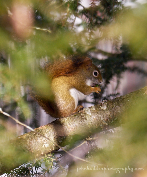
A red squirrel munches happily on hemlock cones in our front yard
Morning Observation:
This morning in Huntington at 8:35AM it’s currently 13 degrees and snowing moderately under overcast skies. Winds are calm. Relative humidity is 88%, dewpoint 10, barometric pressure 30.37” and steady. We’ve picked up just a dusting of snow so far and have 3” at stake.
There is a Winter Storm Warning in effect from 7:00AM this morning to 10:00PM
EST Saturday.
Forecast:
We’ve got a period of very active weather ahead of us through Christmas Day. A warm front lifting though the region today will bring widespread light to moderate snowfall during the day today. After a brief break overnight, precipitation will transition to a wintry mix of snow, sleet, freezing rain, and rain on Saturday, before ending as a period of accumulating snow again Saturday night. It this point, it’s looking like we’ll see mostly snow here in Huntington with the “R” stuff being confined more to our east and south. Total snowfall from the storm should range from 6″ to 12″ across northern New York into central and northern Vermont. Some ice accumulation is likely over eastern and southern Vermont Saturday. Temperatures will be in the teens and 20s today and warm into the 20s and 30s on Saturday before cooler air arrives for Sunday. More snow may be on the way for Christmas Day. Stay tuned…
Today snow is likely. Highs will be around 21F with ESE winds at 5 to 10 mph. Chance of snow is 90% with 3″ to 5″ of snow expected. Tonight snow this evening will taper off and give way to cloudy skies late. Some sleet may mix in late. Lows will be around 20F with SE winds at 5 to 10 mph. Chance of snow is 80% with snowfall around 1″.
Saturday sleet and freezing rain in the morning will change to a mix of rain and snow in the afternoon. Highs will be around 36F with ESE winds at 5 to 10 mph. Chance of precipitation is 100% with snow and ice accumulations of less than one inch. Saturday night snow in the evening will taper off and give way to cloudy skies overnight. Lows will be around 22F with NNW winds at 5 to 10 mph. Chance of snow is 90% with additional snowfall amounts between 2″ to 6″.
Sunday should be overcast with highs around 27F and north winds at 5 to 10 mph. Sunday night should be cloudy with snow likely after midnight. Lows will be around 16F with light and variable winds. Chance of snow is 80% with snow accumulations of 1″ to 3″.
Almanac:
Last year on this date we had a high of 34 and a low fo 29. We picked up 1.5″ and had 5″ at the stake.
Burlington averages for this date are highs of 31 and lows of 16.
The record high was 57°F in 1990.
The record low was -20°F in 1955.
Sky Notes:
Sunrise: 7:26AM
Sunset: 4:17PM
Length of Visible Light: 9h 57m
Length of Day: 8h 50m
Tomorrow will be 0 minutes 5 seconds longer
The Moon is a waxing crescent, 3.7 days old with 14% illumination.
Moonrise: 10:13AM
Moonset: 8:29PM
About Today’s Photo:
The eastern hemlock by the Studio stairs has a bumper crop of cones this season. We have several red squirrels that are happy to feast during the daylight hours.
Panasonic GX8, Lumix 100-300mm lens @ 280mm, ISO 400, f/7.1, 1/400″ exposure.
Thursday, December 21, 2017: The Winter Solstice

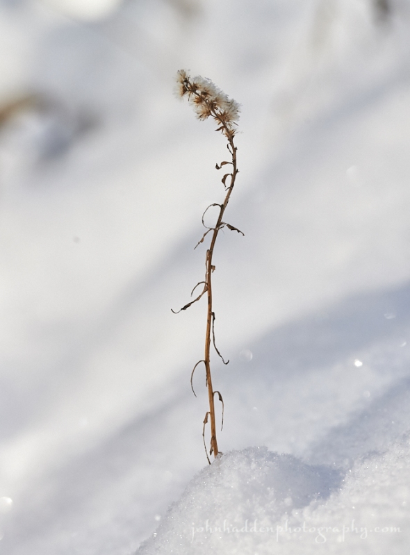
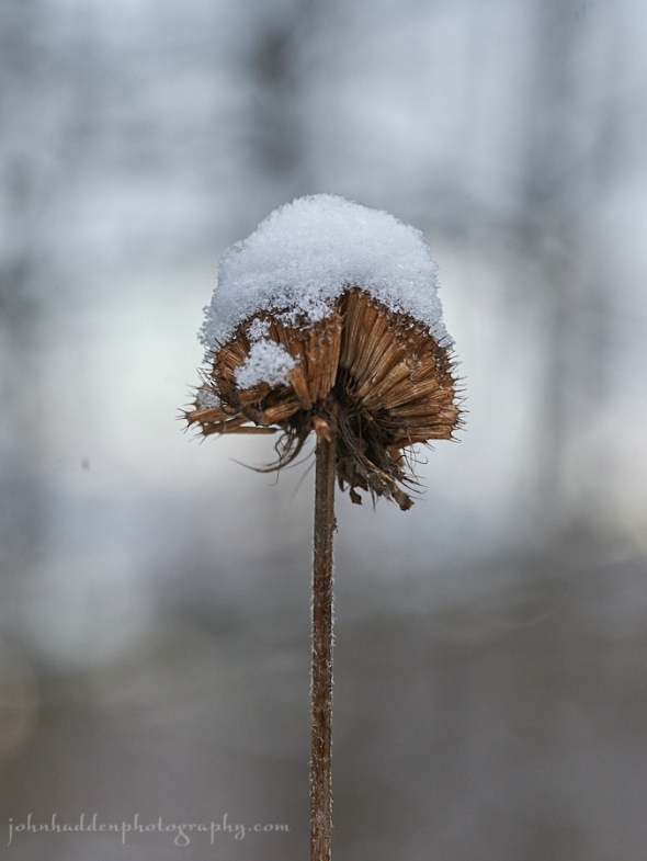
A tiny dried aster in fresh snow along Fargo Brook
Happy Solstice!
Morning Observation:
This morning in Huntington at 7:35AM it’s currently 11 degrees and “snizzling” lightly under overcast skies. Winds are calm. Relative humidity is 82%, dewpoint 6, barometric pressure 30.19” and rising slowly. We picked up a dusting of snow in the past 24hrs and have 3” at the stake. Yesterday’s high was 33, and the overnight low was 11.
There is a Winter Weather Advisory in effect from 7:00AM Friday to 4:00AM EST
Saturday
Forecast:
High pressure will briefly build over the region today bringing quiet weather through tonight. A developing area of low pressure over the eastern Great Lakes will push a warm front through the region Friday bringing snow throughout the day and into Friday night. We may see 3″-6″ of snow from this event. Precipitation will briefly taper off early Saturday morning before redeveloping as freezing rain by Saturday mid-morning then to all rain later in the day as temperatures warm. Precipitation will change back to snow showers Saturday night after a cold front moves through. A brief ridge will move in Sunday before the chance for more snow returns Monday.
We’ll see partly cloudy skies today with highs around 16F and light and variable winds. Tonight should be cloudy skies with lows around 7F and light and variable winds.
Friday snow is likely. Highs will be around 22F with ESE winds at 5 to 10 mph. Chance of snow is 90%. 3″ to 6″ of snow expected. Friday night evening snow will give way to light freezing rain overnight. Lows will be around 21F with SE winds at 10 to 15 mph. Chance of precip is 80% with snow and ice accumulations around 1″.
Saturday should bring freezing rain in the morning changing to rain in the afternoon. Highs will be around 39F with SE winds at 5 to 10 mph. Chance of precipitation is 100%. Saturday night rain will transition back to snow with mostly cloudy skies overnight. Lows will be around 23F with light and variable winds. Chance of snow is 90% with snow accumulations of less than one inch.
Almanac:
Last year on this date we had a high of 37 and a low of 24. We had 3.5″ of snow at the stake.
Burlington averages for this date are highs of 31 and lows of 16.
The record high was 61°F in 1957.
The record low was -22°F in 1955.
Sky Notes:
Sunrise: 7:26AM
Sunset: 4:16PM
Length of Visible Light: 9h 57m
Length of Day: 8h 50m
Tomorrow will be 0 minutes 1 second longer
The Moon is a waxing crescent, 2.7 days old with 8% illumination.
Moonrise: 9:38AM
Moonset: 7:31PM
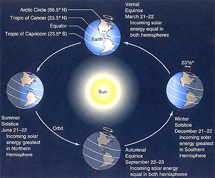
The Winter Solstice occurs today at 11:28AM. This is the shortest day of the year for the Northern hemisphere and marks the astronomical start of winter for us. It is the point in the Earth’s orbit around the sun when the Earth’s axis is inclined fully (~23.5 degrees) to the sun. Southern lattitudes are now in summer. From today until the Summer Solstice in June, our days will continue to get longer. You can read more about the Solstice here.
And here’s a handy graphic for you:
Wednesday, December 20, 2017

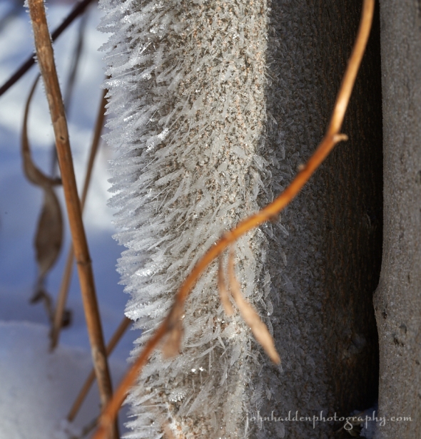
Fine hoar frost crystals form on a tree trunk out in our front field
Morning Observation:
This morning in Huntington at 7:40AM it’s currently 31 degrees under cloudy skies. Winds are out of the southwest at 0-4 mph. Relative humidity is 81%, dewpoint 26, barometric pressure 29.72” and rising rapidly. We picked up 0.04” of rain and 0.30” of snow in the past 24hrs, and have 3” of snow at the stake. Yesterday’s high was 41, and the overnight low was 25.
Forecast:
A secondary cold front will cross the region today bringing cooler temperatures in the upper 20s to lower 30s and scattered morning snow showers. The next chance for significant precipitation will arrive Friday into Saturday when a complex low pressure system tracks northeastward along the St. Lawrence Valley, or to our west across southeastern Ontario. This will bring snow to start on Friday, followed by a wintry mix Friday night, and then transitioning to plain rain on Saturday. At this point, we may be in for some more snow Monday. Stay tuned…
We’ll see cloudy skies with a few snow showers possible this morning becoming partly cloudy this afternoon. Morning highs of 32F will fall to near 20 with NW winds at 10 to 15 mph. Tonight should be mostly cloudy with lows around 9F and NW winds at 5 to 10 mph.
Thursday should be partly cloudy with highs around 15F and light and variable winds. Thursday night should be cloudy with snow showers developing after midnight. Lows will be around 7F with light and variable winds. Chance of snow is 40%.
Friday should be cloudy with snow likely. Highs will be around 23F with ESE winds at 5 to 10 mph. Chance of snow is 80% with snow accumulations of 1″ to 3″. Friday night should bring light snow in the evening, becoming a wintery mix overnight. Lows will be around 20F with ESE winds at 5 to 10 mph. Chance of precipitation is 60% with about 1″ of snow and ice expected. Roadways may be dicey Friday night…
Almanac:
Last year on this date we had a high of 28 and a low of 6. We had 3.5″ of snow at the stake.
Burlington averages for this date are highs of 32 and lows of 17.
The record high was 62°F in 1957.
The record low was -23°F in 1942.
Sky Notes:
Sunrise: 7:25AM
Sunset: 4:16PM
Length of Visible Light: 9h 57m
Length of Day: 8h 50m
Tomorrow will be 0 minutes 3 seconds shorter
The Moon is a waxing crescent, 2 days old with 4% illumination.
Moonrise: 8:58AM
Moonset: 6:35PM
Today is the last day of astronomical fall as tomorrow is the Winter Solstice. The Solstice will arrive at 11:28AM tomorrow!
About Today’s Photo:
These fine hoar frost crystals caught my eye as I was wondering about our front field the other chilly morning. The tree trunk has a diameter of perhaps 3″. There were several gaps in the snow against the bark and the crystals had formed above the gaps. My guess is that there’s a critter (perhaps a meadow vole or mouse) living down beneath the snow, and the crystals formed from the warm rising out of the hole.
Nikon D600, Sigma 105mm macro lens, IOS 320, f/18, 1/160″ exposure.
Tuesday, December 19, 2017

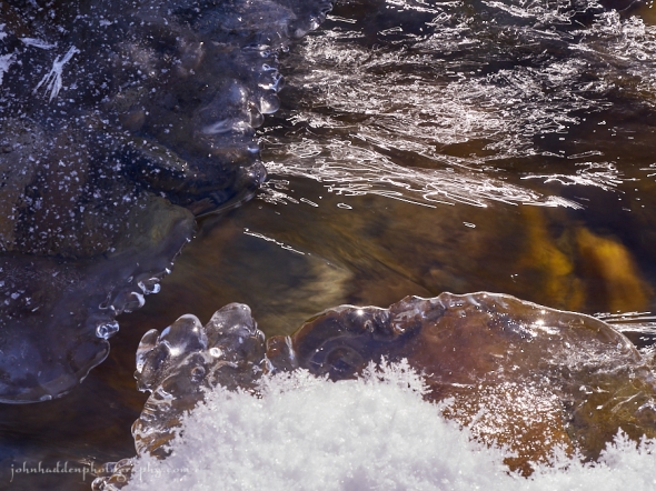
Water, ice, and light squiggles in Fargo Brook
Morning Observation:
This morning in Huntington at 7:30AM it’s currently 36 degrees and drizzling lightly under overcast skies. Winds are out of the south at 0-4 mph. Relative humidity is 98%, dewpoint 35, barometric pressure 29.71” and falling rapidly. We picked up 1.25” of snow in the past 24hrs and have 5” at the stake. Yesterday’s high was 33, and the overnight low was 32.
Forecast:
A warm front will lift through the region this morning bringing breezy south to southwest winds and allowing temperatures to warm into the upper 30s to lower 40s in most locations. Additional rain and snow showers are possible later today into tonight with the passage of a cold front. The next chance for significant precipitation will arrive Friday afternoon into Saturday when a low pressure system is expected to track northeastward along the St. Lawrence Valley bringing a moderate wintry mixed through Friday evening. This mixed precipitation will likely transitioning to plain rain sometime on Saturday before a cold front swings through late Saturday night.
We’ll see cloudy skies today with occasional rain showers. Highs will be near 40F with SW winds at 10 to 20 mph. Chance of rain is 90%. Tonight should be partly cloudy with a few flurries or snow showers possible. Lows will be around 27F with west winds at 10 to 20 mph.
Wednesday should be mostly cloudy early with some breaks in the clouds later in the day. Highs will be around 28F with WNW winds at 10 to 20 mph. Wednesday night should be overcast with a low of 8F and NNW winds at 5 to 10 mph.
Thursday—the Winter Solstice—is looking cloudy early, followed by partial clearing. Highs will be around 14F with light and variable winds. Thursday night should be mostly cloudy with snow showers developing after midnight. Lows will be around 6F with light and variable winds. Chance of snow is 50%.
Almanac:
Last year on this date we had a high of 18 and a low of -3. We picked up 0.13″ of rain and 0.20″ of snow. We had 3.5″ at the stake.
Burlington averages for this date are highs of 32 and lows of 17.
The record high was 49°F in 1895.
The record low was -16°F in 1942.
Sky Notes:
Sunrise: 7:25AM
Sunset: 4:15PM
Length of Visible Light: 9h 57m
Length of Day: 8h 50m
Tomorrow will be 0 minutes 8 seconds shorter
The Moon is a waxing crescent, 1 day old with 1% illumination.
Moonrise: 8:13AM
Moonset: 5:43PM
About Today’s Photo:
I stumbled across the “light squiggle” phenomenon a few years back while shooting moving water. With the camera’s shutter speed set relatively slow—1/20″—and shooting towards the sun, the bouncing sunlight traces crazy scribbles across the surface of the water. I love the look and find myself trying to capture it all the time.
Panasonic GX8, Lumix 14-140mm lens @ 61mm, ISO 200, f/18, 1/20″ exposure.
Monday, December 18, 2017

Delicate hoar frost “feathers” on the ice of Fargo Brook
Morning Observation:
This morning in Huntington at 8:00AM it’s currently 16 degrees under overcast skies. Winds are calm. Relative humidity is 91%, dewpoint 14, barometric pressure 30.08”. We picked up just a dusting of new snow in the past 24hrs and have 4” at the stake. Yesterday’s high was 18, and the overnight low was 5.
Forecast:
A warm front approaching from the southwest will bring increasing clouds and widespread light snow this morning into the afternoon. We could see between 1″ and 3″ with localized totals around 4″ in the southern Greens. A brief warm up is expected on Tuesday, with gusty south to southwest winds. Another warm front Tuesday evening will bring a few rain or snow showers before a return to colder
temperatures Wednesday. The next chance for significant precipitation will arrive Friday night into Saturday when a low pressure system passing to our west is expected to bring mixed wintry precipitation, transitioning to plain rain as warmer air moves in on south winds Saturday. Stay tuned…
We’ll see occasional snow showers today with highs around 33F and south winds at 5 to 10 mph. Chance of snow is 60% with snow accumulations maybe an inch. Tonight should be cloudy with snow showers mainly during the evening. Lows will be around 31F with SSW winds at 5 to 10 mph. Chance of snow is 60 with total snow accumulations of 1″-3″.
Tuesday should be cloudy with occasional rain showers in the afternoon. Highs will be near 40F with SSW winds at 10 to 20 mph. Chance of rain is 40%. Tuesday night should be mostly cloudy with snow showers developing after midnight. Lows will be around 28F with west winds at 10 to 20 mph. Chance of snow is 40%.
Wednesday’s looking cloudy with highs near 30F and NW winds at 10 to 20 mph. Wednesday night should be cloudy with lows around 9F and NW winds at 5 to 10 mph.
Almanac:
Last year on this date we had a high of 48 and a low of 10. We picked up 0.46″ of rain and had 4″ of snow at the stake.
Burlington averages for this date are highs of 32 and lows of 17.
The record high was 57°F in 1921.
The record low was -13°F in 1919.
Sky Notes:
Sunrise: 7:24AM
Sunset: 4:15PM
Length of Visible Light: 9h 57m
Length of Day: 8h 51m
Tomorrow will be 0 minutes 13 seconds shorter
The Moon is new, 0.1 days old with 0% illumination.
Moonrise: 7:23AM
Moonset: 4:55PM
About Today’s Photo:
When the temperatures drop below zero, the moisture from the still-open water on Fargo Brook spur creation of fine feather hoar frost crystals. If you look closely, you can see the fine branchin dendredic crystal formations of the “feather” at the center of the image.
Nikon D600, Sigma 105mm macro lens, ISO 800, f/18, 1/320″ exposure.
Sunday, December 17, 2017

Rime ice and snow atop Mad River Glen
Morning Observation:
This morning in Huntington at 8:30AM it’s currently -2 degrees under partly cloudy skies. Winds are calm. Relative humidity is 97%, dewpoint -5, barometric pressure 30.33” and rising slowly. We picked up 0.30” of new snow in the past 24hrs and have 4” at the stake. Yesterday’s high was 27, and the overnight low was -4.
Forecast:
High pressure over the region will deliver quiet and seasonably chilly conditions today with widespread morning below-zero readings bumping up into the mid-teens by midday. A warm front will bring light snow across the region tonight into tomorrow with 1″ in valley locations and up to 4″ above 1500′. A second warm front will lift through the region on Tuesday bringing initial snow showers mixing with or transitioning to the “R” word as temperatures rise into the mid-30s to low 40s. A cold front will move in behind the warm front late Tuesday night into Wednesday and any “R” should transitions back to snow. The longterm forecast is seeing another warmup Friday into Saturday. Stay tuned…
We’ll see partly cloudy skies today with highs around 15F and light and variable winds. Tonight should be partly cloudy early, giving way to cloudy skies late. Lows will be around 6F with light and variable winds.
Monday should be mostly cloudy with snow showers. Highs will be around 31F with south winds at 5 to 10 mph. Chance of snow is 60% with snow accumulations of 1″ to 3″. Monday night should be mostly cloudy with snow showers before midnight. Lows will be around 29F with SSW winds at 5 to 10 mph. Chance of snow is 40%.
Tuesday should be cloudy in the morning with off and on rain showers during the afternoon hours. Highs will be near 40F with SSW winds at 10 to 20 mph. Chance of rain is 50%. Tuesday night should be cloudy early with breaks late. A few flurries or snow showers are possible. Lows will be around 28F with west winds at 10 to 15 mph.
Almanac:
Last year on this date we had a high of 36 and a low of 15. We picked up 0.20″ of new snow and had 5″ at the stake.
Burlington averages for this date are highs of 33 and lows of 18.
The record high was 56°F in 2000 (we had a high of 54).
The record low was -11°F in 2013 (we had a low of -14).
Sky Notes:
Sunrise: 7:23AM
Sunset: 4:15PM
Length of Visible Light: 9h 58m
Length of Day: 8h 51m
Tomorrow will be 0 minutes 17 seconds shorter
The Moon is a waning crescent, 28 days old with 0.7% illumination.
Moonrise: 6:29AM
Moonset: 4:11PM
About Today’s Photo:
Opening day at Mad River Glen on Friday was a bluebird of a day. Rime ice and fresh snow bedecked the trees surrounding the top of the Double Chair.
Panasonic GM5, Lumix 12-32mm lens @ 12mm, ISO 400, f/18, 1/320″ exposure.
Saturday, December 16, 2017

Mountain ash berries along the trail at Mad River Glen
Morning Observation:
This morning in Huntington at 8:30AM it’s currently 20 degrees under overcast skies. A few lazy snowflakes are drifting down. Relative humidity is 85%, dewpoint 17, barometric pressure 29.84” and rising. We’ve picked up just a dusting of new snow in the past 24hrs and have 4” at the stake. Yesterday’s high was 25, and the overnight low was 14.
Forecast:
A weak upper trough and surface low passing to our northwest this morning will bring scattered snow showers to the region through the rest of the morning with little accumulation. A brief ridge of high pressure will bring a quiet end to the weekend on Sunday, before the pattern becomes active again next week with a warming trend and several chances for precipitation, especially on Tuesday.
We’ll see overcast skies today with a few flurries or snow showers possible this morning. Highs will be near 25F with WNW winds at 5 to 10 mph. Tonight should be partly cloudy with lows around 8F and light and variable winds.
Sunday should be mostly cloudy early then become partly cloudy later in the day. Highs will be around 17F with light and variable winds. Sunday night should be mostly cloudy with lows around 9F and light and variable winds.
Monday should bring intermittent snow showers, especially early. Highs will be around 32F with light and variable winds. Chance of snow is 60% with snowfall around 1″. Monday night should be cloudy with lows around 29F and south winds at 5 to 10 mph.
Almanac:
Last year on this date we had a high of 15 and a low of -6. We picked up 0.75″ of new snow and had 5.5″ at th stake.
Burlington averages for this date are highs of 33 and lows of 18.
The record high was 54°F in 1982.
The record low was -18°F in 1917.
Sky Notes:
Sunrise: 7:23AM
Sunset: 4:14PM
Length of Visible Light: 9h 58m
Length of Day: 8h 51m
Tomorrow will be 0 minutes 22 seconds shorter
The Moon is a waning crescent, 27.8 days old with 3% illumination.
Moonrise: 5:33AM
Moonset: 3:33PM
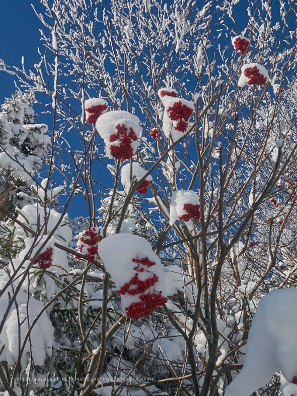
About Today’s Photo:
Yesterday was opening day for Mad River Glen, and a lovely bluebird one it was! I noticed that there was a prodigious crop of mountain ash berries on most of the ash trees up at elevation. This bodes well for birds as it’s a favored food source. I recall several years back when there was another bumper crop, and I was seeing flocks of robins feeding in the middle of winter at elevations over 3600′.
Panasonic GM5, Lumix 12-32mm lens @ 20mm, ISO 400, f/10, 1/640″ exposure.
Friday, December 15, 2017

Junco tracks in fresh snow
Morning Observation:
This morning in Huntington at 7:30AM it’s currently -2 degrees under clear skies. Winds are calm. Relative humidity is 86%, dewpoint -5, barometric pressure 30.05” and steady. We have 4.5” of snow at the stake. Yesterday’s high was 15, and the overnight low was -5.
Forecast:
High pressure over the region this morning will continue to provide clear skies and slightly warmer temperatures today. A weak upper trough and surface low passing northwest of the region tonight will bring a chance for snow showers tonight through early Saturday—we may see an inch or two—with the weekend ending cool and dry on Sunday.
We’ll see sunshine early followed by cloudy skies this afternoon. Highs will be around 24F with light and variable winds. Tonight should be cloudy with snow showers developing after midnight. Lows will be around 18F with light and variable winds. Chance of snow is 60% with maybe 3″ falling over mountain summits and 1″ or less on valley floors.
Saturday should be cloudy early with partial sunshine expected late. There may be a few lingering flurries or snow showers possible in the morning. Highs will be near 25F with west winds at 5 to 10 mph. Saturday night should be partly cloudy with lows around 9F and light and variable winds.
Sunday’s looking mostly cloudy with highs around 16F and light and variable winds. Sunday night should be cloudy with snow showers developing after midnight. Lows will be around 10F with light and variable winds. Chance of snow is 40% with little or no accumulation.
Almanac:
Last year on this date we had a high of 23 and a low of -2. We picked up 2.25″ of new snow and had 6.5″ at the stake.
Burlington averages for this date are highs of 33 and lows of 19.
The record high was 62°F in 1901.
The record low was -12°F in 1943.
Sky Notes:
Sunrise: 7:22AM
Sunset: 4:14PM
Length of Visible Light: 9h 58m
Length of Day: 8h 52m
Tomorrow will be 0 minutes 27 seconds shorter
The Moon is a waning crescent, 27 days old with 7% illumination.
Moonrise: 4:34AM
Moonset: 2:58PM
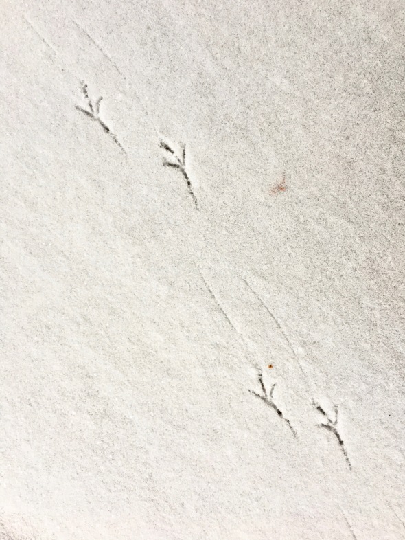
About Today’s Photo:
Slate-colored Juncos are in abundance this year at our feeder. It seems like we’ve got a herd of a couple dozen at times hopping about under the feeders and in the rhododendrons next to the house. Their tiny footprints are everywhere!
iPhone 6S
Thursday, December 14, 2017

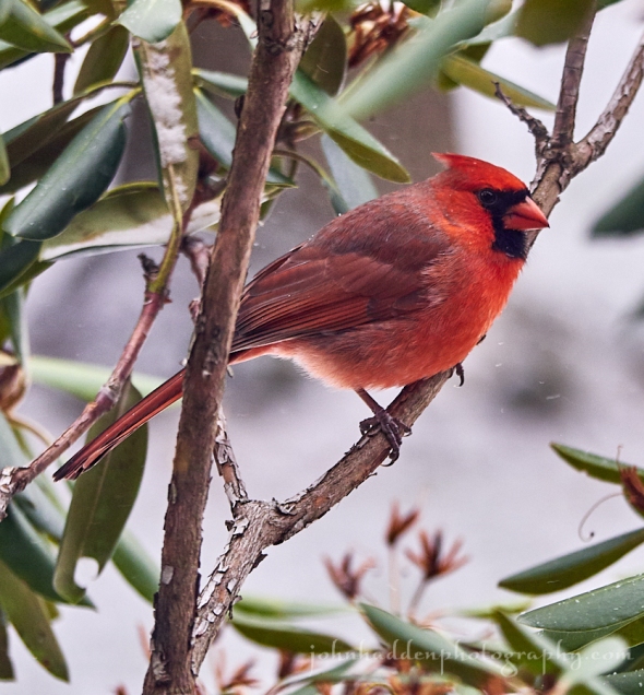
A bright male cardinal pauses briefly in the rhododendron near one of our feeders
Morning Observation:
This morning in Huntington at 7:45AM it’s currently 8 degrees under partly cloudy skies. Wind are calm. Relative humidity is 83%, dewpoint 4, barometric pressure 29.64” and rising rapidly. We picked up just a dusting of new snow in the past 24hrs and have 5” and the stake. Yesterday’s high was 23 and the overnight low got down to -1.
Forecast:
Dry and cold weather will be the rule for today through Friday with surface high pressure ridge the region. The coldest airmass of this meteorological winter season so far is sitting atop us, and maximum temperatures will top out in the
single digits and teens today which is about 15 to 20 degrees below seasonal normals. A weak clipper will bring a chance for some light snow showers Friday night into Saturday, and temperatures will moderate heading towards next week.
We’ll see partly cloudy skies today with highs around 14F and WNW at 10 to 15 mph. Tonight should be clear with lows near 5F and WSW winds at 5 to 10 mph.
Friday should be mostly sunny during the morning hours and becoming overcast in the afternoon. Highs will be around 21F with light and variable winds. Friday night should be cloudy with snow showers. Lows will be around 18F with south winds at 5 to 10 mph. Chance of snow is 50%. We shouldn’t see much accumulation from this clipper system.
Saturday should bring some snow showers before noon then become partly cloudy later. Highs will be around 23F with west winds at 5 to 10 mph. Chance of snow is 40%. Saturday night should be partly cloudy with lows around 8F and light and variable winds.
Almanac:
Last year on this date we had a high of 33 and a low of 20. We picked up a trace of new snow and had 4.5″ at the stake.
Burlington averages for this date are highs of 34 and lows of 19.
The record high was 63°F in 1901.
The record low was -11°F in 1933.
Sky Notes:
Sunrise: 7:21AM
Sunset: 4:14PM
Length of Visible Light: 9h 59m
Length of Day: 8h 52m
Tomorrow will be 0 minutes 31 seconds shorter
The Moon is a waning crescent, 26 days old with 13% illumination.
Moonrise: 3:34AM
Moonset: 2:27PM
About Today’s Photo:
Our bird feeders are busy this time of year especially with the cold temperatures. We have a pair of cardinals in residence for the season, and the male perched briefly in the rhododendron near the kitchen window allowing me to get a shot of him.
Panasonic GX8, Lumix 100-300mm lens @ 127mm, ISO 800, f/4.5, 1/160″ exposure.
Wednesday, December 13, 2017

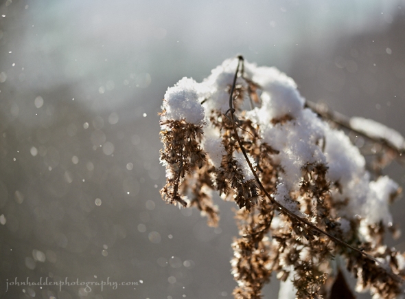
Snow falls on dried goldenrod near the pond
Morning Observation:
This morning in Huntington at 7:35AM it’s currently 17 degrees under overcast skies. A few lazy snowflakes are drifting down. Relative humidity is 85%, dewpoint 13, barometric pressure 29.30” and falling slowly. We picked up 5.25” of new snow in the past 24hrs and have 6” at the stake. Yesterday’s high was 35, and the overnight low was 17.
The Winter Storm Warning remains in effect until 7:00 PM EST this evening.
Forecast:
Deep low pressure will pull away into eastern Canada and the Maritimes today into tonight. The Winter Storm Warning is still in effect for the northern Greens were a few more inches of snow could fall before tapering off by midday. Cold and blustery weather is expected into Thursday behind the departing low. Temperatures are expected to moderate going into next weekend with a few snow showers expected.
We’ll see cloudy skies today with snow showers mainly during the morning. Highs will top our around 17F with WNW at 10 to 20 mph. Chance of snow is 90% with snow accumulations of an inch or so. Tonight should be partly cloudy and chilly with lows around 6F and west winds at 10 to 20 mph.
Thursday should be sunny and chilly with highs around 15F and WNW winds at 10 to 15 mph. Thursday night should be mostly clear with lows around 6F and WSW winds at 5 to 10 mph.
Friday looking mostly sunny with highs around 22F and south winds at 5 to 10 mph. Friday night should be cloudy with late-night snow showers as a weak clipper system moves through. Lows will be around 17F with light and variable winds. Chance of snow is 40%.
Almanac:
Last year on this date we had a high of 37 and a low of 17. We picked up 1.75″ of new snow and had 5″ at the stake.
Burlington averages for this date are highs of 34 and lows of 20.
The record high was 56°F in 1946.
The record low was -9°F in 1982.
Sky Notes:
Sunrise: 7:20AM
Sunset: 4:14PM
Length of Visible Light: 9h 59m
Length of Day: 8h 53m
Tomorrow will be 0 minutes 36 seconds shorter
The Moon is a waning crescent, 25 days old with 21% illumination.
Moonrise: 2:33AM
Moonset: 1:59PM
About Today’s Photo:
Snow falls through filtered sunlight onto dried goldenrod by our pond.
Nikon D600, Sigma 105mm macro lens, ISO 800, f/3.5, 1/4000″ exposure.
Tuesday, December 12, 2017

A tuft of new snow on bee balm
Morning Observation:
This morning in Huntington at 8:20AM it’s currently 29 degrees and blowing and snowing under overcast skies. Winds are out of the south at 6-8 mph. Relative humidity is 83%, dewpoint 24, barometric pressure 29.64” and falling rapidly. We picked up 0.50” of new snow in the past 24hrs and have 1” at the stake. Yesterday’s high was 29, and the overnight low was 13.
A Winter Storm Warning remains in effect until 7:00 PM EST Wednesday.
Forecast:
Phase one of our two-part snow storm is underway with blowing snow falling throughout the day today. Snow should taper off a bit in the early evening hours before the next phase moves in overnight into Wednesday bringing a more concentrated shot of snow to the entire region. The deepening low pressure system responsible will cross the region today and then back into the region Wednesday. We could see up to 10″ from the storm in the northern Greens with lesser amounts south. Behind this system chilly temperatures are expected through the end of the week with periodic chances of flurries and light snow, with the best chances occurring later in the weekend. Long term forecasts suggest that this shot of snow should stick around to Christmas… Fingers crossed…
Snow this morning will transition to snow showers this afternoon. Highs will be around 31F with gusty SE winds at 10 to 20 mph. Chance of snow is 90% with snow accumulations of 1″ to 3″ during the daylight hours with higher amounts south. Tonight snow should taper off briefly before reblossoming late. Lows will be near 15F with NW winds at 5 to 10 mph. Chance of snow is 80% with 3″ to 6″ of snow expected overnight.
Wednesday should be cloudy with snow showers mainly during the morning. Highs will be around 19F with WNW winds at 10 to 20 mph. Chance of snow is 60% with snowfall around one inch. Wednesday night should be cloudy early with partial clearing expected late. It’ll be chilly with lows near 5F with west winds at 10 to 20 mph.
Thursday’s looking mostly sunny and cold with highs only around 12F with WNW winds at 5 to 10 mph. Thursday night should be clear to partly cloudy with lows around 2F and WSW winds at 5 to 10 mph.
Almanac:
Last year on this date we had a high of 35 and a low of 25. We picked up 2″ of new snow and had 2.75″ at the stake.
Burlington averages for this date are highs of 34 and lows of 20.
The record high was 59°F in 1899
The record low was -13°F in 1977.
Sky Notes:
Sunrise: 7:20AM
Sunset: 4:14PM
Length of Visible Light: 10h 0m
Length of Day: 8h 54m
Tomorrow will be 0 minutes 40 seconds shorter
The Moon is a waning crescent, 24 days old with 29% illumination.
Moonrise: 1:31AM
Moonset: 1:31PM
About Today’s Photo:
Fresh snow sets a little cap atop a dried bee balm head by the pond.
Nikon D600, Sigma 105mm macro lens, ISO 800, f/8, 1/640″ exposure.
Monday, December 11, 2017

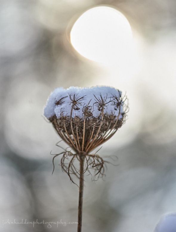
Dried Queen Anne’s lace becomes a basket of snow
Morning Observation:
This morning in Huntington at 7:30AM it’s currently 22 degrees and snowing lightly under overcast skies. Winds are calm. Relative humidity is 88%, dewpoint 19, barometric pressure 29.92” and rising rapidly. We picked up 0.50” of snow overnight and have 1” at the stake. Yesterday’s high was 32, and the overnight low was 22.
There is a Winter Storm Warning in effect (!!!) from 1 am Tuesday to 7 PM EST
Wednesday. Get your snow shovels ready!
Forecast:
Weak high pressure will crest over the region today with any morning light snow showers ending and seasonably cold temperatures expected. A two phase low pressure system will track across the region on Tuesday bringing modest snowfall, then backing and intensify to our northeast on Wednesday and bringing
a more widespread moderate to locally heavy snowfall Wednesday. We could see a two day total of 6″-10″ in our area. Behind this system, a cold airmass settles into the region keeping temperatures below seasonal norms into Friday before temperatures moderate just a bit by next weekend.
Any snow this morning will give way to partly cloudy skies this afternoon. Highs will be near 25F with north winds at 5 to 10 mph. Chance of snow is 100% the snow accumulations of less than one inch. Tonight should be cloudy with snow showers developing after midnight. Lows will be around 16F with ESE at 10 to 15 mph. Chance of snow is 50% with snow accumulations of less than one inch.
Tuesday should be cloudy and snowy. Highs will be around 35F with SE winds at 10 to 20 mph. Chance of snow is 100% with snow accumulations of 3″ to 5″. Snow showers will continue into Tuesday night and become steadier overnight. Lows will be around 18F with west winds at 5 to 10 mph. Chance of snow is 70% with snow accumulations of 1″ to 3″.
Wednesday, heavier snow during the morning will taper to snow showers during the afternoon. Highs will be around 21F with WNW winds at 10 to 20 mph. Chance of snow is 70% with 1″ to 3″ of snow expected. Wednesday night should bring scattered lingering snow showers during the evening, then become partly to mostly cloudy overnight. Lows will drop to around 6F with west winds at 10 to 20 mph. Chance of snow is 40%.
Almanac:
Last year on this date we had a high of 28 and a low of 7. We picked up 0.50″ of new snow and had 1.75″ at the stake.
Burlington averages for this date are highs of 35 and lows of 21.
The record high was 61°F in 1966.
The record low was -13°F in 1958.
Sky Notes:
Sunrise: 7:19AM
Sunset: 4:14PM
Length of Visible Light: 10h 1m
Length of Day: 8h 54m
Tomorrow will be 0 minutes 45 seconds shorter
The Moon is a waning crescent, 23 days old with 39% illumination.
Moonrise: 12:26AM
Moonset: 1:04PM
About Today’s Photo:
A light morning snowfall turns a dried Queen Anne’s lace seed head into a basket of snow. The morning sun behind lights the scene.
Nikon D600, Sigma 105mm macro lens, ISO 800, f/3.3, 1/4000″ exposure.
Sunday, December 10, 2017

Convoluted forms in puddle ice
Morning Observation:
This morning in Huntington at 8:05AM it’s currently 27 degrees under mostly cloudy skies. Winds are calm. Relative humidity is 93%, dewpoint 25, barometric pressure 29.69” and steady. We picked up 0.50” of snow overnight and have 0.50” at the stake. Yesterday’s high was 33, and the overnight low was 25.
Forecast:
A weak trough of low pressure moving from the Great Lakes will bring snow showers to much of the region today. Tonight lake effect snow from Lake Ontario will move across parts of the region with minor snow accumulations possible mainly over portions of northern New York. Relatively dry weather is expected on Monday before the next northern clipper low moves across the region Tuesday into Wednesday bringing more widespread light to moderate snowfall. We could see a few inches out of that one. Stay tuned!
We’ll see mostly cloudy skies today with a few flurries or snow showers possible. Highs will be around 32F with west winds at 10 to 20 mph. Tonight should be cloudy late-night snow showers. Lows will be around 21F with SW winds at 5 to 10 mph. Chance of snow is 50% with perhaps an inch of accumulation.
Monday should bring a few flurries early. It’ll be mostly cloudy early with partial sunshine expected later in the day. Highs will be around 24F with NNW winds at 5 to 10 mph. Monday night should be cloudy with snow showers developing after midnight. Lows will be around 16F with ESE winds at 5 to 10 mph. Chance of snow is 50% with snow accumulations of less than one inch.
Tuesday snow is likely. Highs will be around 30F with ESE winds at 10 to 15 mph. Chance of snow is 90% with snow accumulations of 1″ to 3″. Tuesday night should be mostly cloudy with snow showers lingering before midnight. Lows will be around 16F with west winds at at 5 to 10 mph. Chance of snow is 60%.
Almanac:
Last year on this date we had a high of 21 and a low of 15. We had 1.5″ of snow at the stake.
Burlington averages for this date are highs of 35 and lows of 21.
The record high was 61°F in 1966.
The record low was -9°F in 1958.
Sky Notes:
Sunrise: 7:18AM
Sunset: 4:14PM
Length of Visible Light: 10h 1m
Length of Day 8h 55m
Tomorrow will be 0 minutes 49 seconds shorter.
The moon is in its last quarter, 22 days old with 49% illumination.
No moonrise
Moonset: 12:35PM
About Today’s Photo:
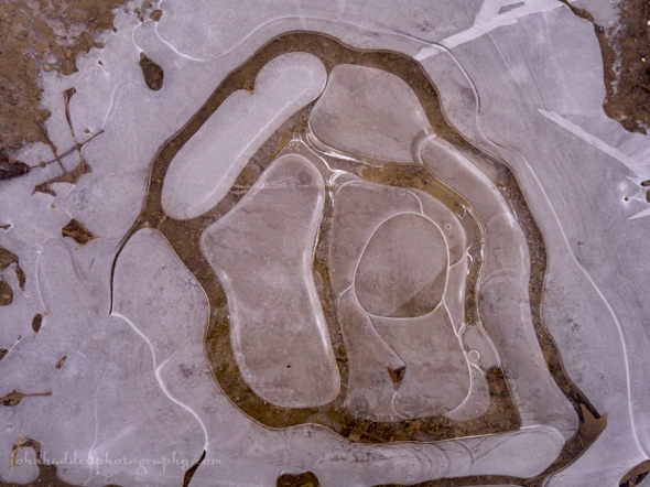
A thin skim of ice forms on a driveway puddle. What do you see?
Panasonic GX8, Lumix 14-140mm lens @ 32mm, ISO 1600, f/4.9, 1/4000″ exposure.
Saturday, December 9, 2017

A well warn beaver path though the grasses by one of the Taft Road beaver ponds
Morning Observation:
This morning in Huntington at 8:30AM it’s currently 25 degrees under partly cloudy skies. Winds are calm. Relative humidity is 87%, dewpoint 22, barometric pressure 29.96”. Yesterday’s high was 34, and the overnight low was 21.
Forecast:
We’re sitting between two weather systems today with a trough of low pressure to our west over the Great Lakes and a nor’easter type low of deeper moisture off the East Coast. The deeper moisture will eventually move westward and bring light snow to Vermont this afternoon and tonight. Areas east of the Greens may see 1-3″ while we’ll see just a trace in the Champlain Valley. The low to our west will move in later tonight and Sunday and bring snow showers to our immediate region with maybe a couple inches. A more widespread snow event is expected Monday night into Wednesday morning as a low pressure system moves down from Canada. Stay tuned!
Morning sunshine will become overcast later today. Highs will be around 34F with light and variable winds. Tonight should be cloudy with a few flurries or snow showers possible. Lows will be around 26F with light and variable winds.
Sunday should be cloudy with a few flurries or snow showers possible. Highs will be around 33F with west winds at 10 to 15 mph. Sunday night should be mostly cloudy with a few flurries or snow showers possible. Lows will be around 17F with west winds at 10 to 15 mph.
Monday’s looking cloudy skies with partial clearing later. Highs will be around 23F with light and variable winds. Monday night should be cloudy with showers developing after midnight. Lows will be around 18F with ESE winds at 5 to 10 mph. Chance of snow is 60% with snow accumulations around one inch.
Almanac:
Last year on this date we had a high of 31 and a low of 19. We had 1.5″ of snow at the stake.
Burlington averages for this date are highs of 36 and lows of 22.
The record high was 61°F in 1966.
The record low was -10°F in 1902.
Sky Notes:
Sunrise: 7:17AM
Sunset: 4:14PM
Length of Visible Light: 10h 2m
Length of Day: 8h 56m
Tomorrow will be 0 minutes 54 seconds shorter
The Moon is waning gibbous, 21 days old with 60% illumination
Moonrise: 11:21PM
Mooset: 12:05PM
About Today’s Photo:
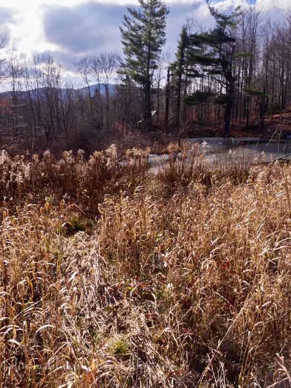
The brief warm snap and rain reopened many of the beaver ponds locally, so the beavers got an opportunity to get out of their lodges. Their path is cleary visible through the grasses near the Taft Road pond complex. There’s a stand of young birch at the other end of this path—a preferred source of food for the large rodents.
Panasonic GX8, Lumix 14-140mm @ 14mm, ISO 800, f/18, 1/200″ exposure.
Friday, December 8, 2017

Fern and moss still life
Morning Observation:
This morning in Huntington at 7:30AM it’s currently 28 degrees and snowing lightly under overcast skies. Winds are calm. Relative humidity is 87%, dewpoint 24, barometric pressure 29.94” and steady. We’ve picked up just a dusting of snow. Yesterday’s high was 35, and the overnight low was 23.
Forecast:
Lake effect snow over northern New York and portions of western Vermont will wind on down today as a southerly airflow sets up. A brief ridge of high pressure will build in this evening through Saturday afternoon bringing some breaks in the clouds to start the weekend. Low pressure moving up the coast will spread some light snowfall over Vermont Saturday night into Sunday with highest amounts east of the Greens where a couple of inches may fall. Another low moving in from the Great Lakes will add the potential of a bit more snow west of the Greens Sunday. The next chance for snow arrives Tuesday into Wednesday and we may see a few inches out of that one. Fingers crossed…
We’ll see snow showers this morning with glimpses of sunshine later today. Highs will be around 33F with SW winds at 10 to 15 mph. Chance of snow is 40%. Tonight should be partly cloudy with lows around 23F and SSW winds at 5 to 10 mph.
Saturday should be cloudy with snow showers developing in the afternoon. Highs will be around 34F with light and variable winds. Chance of snow is 40%. Tomorrow night should be cloudy with snow showers. Lows will be near 25F with light and variable winds. Chance of snow is 50% with snow accumulations of less than one inch west of the Greens.
Sunday’s looking cloudy with a few flurries or snow showers possible. Highs will be around 32F with west winds at 10 to 20 mph. Sunday night should be partly cloudy early, with some snow showers arriving later at night. Lows will be around 21F with SW winds at 10 to 15 mph. Chance of snow is 60% with snowfall amounts under an inch.
Almanac:
Last year on this date we had a high of 37 and a low fo 29. We had 1.5″ of snow at the stake.
Burlington averages for this date are highs of 36 and lows of 22.
The record high was 58°F in 1927.
The record low was -10°F in 1906.
Sky Notes:
Sunrise: 7:16AM
Sunset: 4:14PM
Length of Visible Light: 10h 3m
Length of Day: 8h 57m
Tomorrow will be 0 minutes 58 seconds shorter
The Moon is waning gibbous, 20 days old with 71% illumination.
Moonrise: 10:12PM
Moonset: 11:30AM
About Today’s Photo:
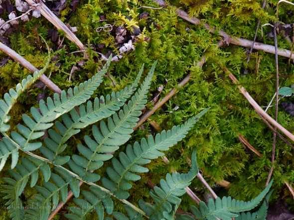
It’s hard to find color out in the woods these days, but there’s still a bit o’ green. Ferns and mosses will keep their color as the snow piles deep (hopefully!) soon.
Panasonic GX8, Lumix 14-140mm lens @ 46mm, ISO 900, f/9, 1/500″ exposure
