Wednesday, February 28, 2024

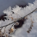
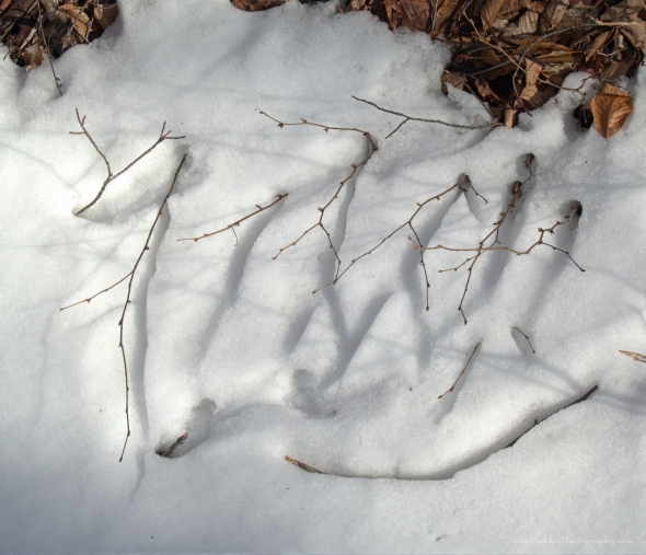 Twigs emerging from the snowpack
Morning Observation:
This morning in Huntington at 7:10AM it’s currently a balmy 52 degrees under cloudy skies. Winds are out out of the south at 5-8 mph. Relative humidity is 86%, dewpoint 48, barometric pressure 29.58”. We’re down to a spotty 1” of snow at the stake. Yesterday’s high was 61, and yesterday’s low was 24. The overnight low got down to 46.
This morning in North Hero it’s currently 47 degrees under cloudy skies. Winds are out of the south at 18-20 mph. Relative humidity is 92%, dewpoint 45, barometric pressure 29.57”. Yesterday’s high was 55, and yesterday’s low was 30. The overnight low got down to 43.
There is a Wind Advisory and a Flood Watch in effect for our region from 1:00PM today until 7:00AM Thursday.
Forecast Discussion:
We’ve got some wooly weather ahead of us for the next 24 hours or so. Morning radar imagery shows low pressure over the northern Great Lakes at this hour and a warm front extending southeastward with an accompanying line of showers. These showers will be pushing into the Vermont by midmorning bringing a round of showers to the region as highs bump up into the upper 50s to low 60s once again. Southerly winds will be on the increase through the day gusting to 45 mph over the Champlain Valley by this afternoon. A sharp cold front will swing through later this afternoon/evening renewing chances for rain, which may be heavy at times, and include a few rumbles of thunder as well. Much colder air will move in behind the front as winds shift into the west and any remaining precipitation changes over to snow. We may see a dusting to half an inch here in Huntington before it winds down quickly tonight. Dry and unseasonably chilly air will make a brief visit Thursday as high pressure crests over the region with daytime highs only around 20 and gusty west wind under mostly sunny skies. The cool-down will be brief, however, as the ridge of high pressure slides to our east allowing for a southerly return flow to bring more warm air back into the region for the weekend. Highs on Friday are expected to warm into the low 40s, with low 50s on Saturday, and mid to upper 50s by Sunday. The next chance for precipitation looks to hold off until Monday night, but unseasonably warm conditions look to persist at least through the end of next week.
3-Day Forecast:
We’ll see cloudy skies today with showers, mainly after 10:00AM. Highs will be near 62 with south winds 8-13 mph increasing to 18-23 mph in the afternoon in Huntington and 26-31 mph in the Champlain Valley. Winds could gust as high as 46 mph. Chance of precipitation is 80% with rainfall amounts between 0.10″-0.25″ possible. Tonight should be cloudy with rain and snow showers before 11:00PM, then a chance of snow showers between 11:00PM and 1:00AM. Some thunder is also possible with the passage of the cold front. Lows will drop to around 14 with south winds 20-24 mph becoming westerly 18-25 after midnight. Winds could gust as high as 47 mph. Chance of precipitation is 100% with snow accumulations of less than 0.50″ possible.
Thursday should be mostly sunny with a high near 20 and west winds 18-25 mph gusting to 40 mph. Thursday night should be partly cloudy with a low around 14 and west winds 13-18 mph decreasing to 6-11 mph after midnight.
Friday should start out mostly cloudy, then gradually become sunny, with a high near 43 and south winds 8-15 mph. Friday night should be partly cloudy with a low around 33 and south winds 10-13 mph.
Almanac:
Last year on this date in Huntington we had a high of 35 and a low of 25. We had 8″ of snow at the stake.
Last year in North Hero we had a high of 35 and a low of 21. We had 5″ of snow at the stake.
Burlington averages for this date are a low of 18 and a high of 35.
The record low was -13 in 1950.
The record high was 59 in 2018 (we had a high of 53 in Huntington). Burlington set a new record high of 65 yesterday and is likely to break the record again today.
The Lake Champlain lake level in Burlington is 96.16′.
The water temperature is 37˚.
Last year’s lake level was at 96.26′.
The Mt. Mansfield snow stake depth is 58″ (measured on the 26th).
The average depth for this date is 64″.
Mt. Washington Summit Conditions
Current Temperature: 32˚
Winds are out of the south at 45 gusting to 56 mph
24 hr Precipitation: 0.5″ snow, 0.19″ melted precipitation
Visibility: less than 1/16 mile in fog and drizzle
Sky Notes:
Sunrise: 6:31AM
Sunset: 5:38PM
Length of day: 11:06:30
Today will be 3:00 longer than yesterday.
The Moon is waning gibbous, 18 days old with 87% illumination.
Moonrise: 9:58PM
Moonset: 8:06AM
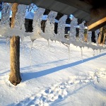
About Today’s Photo:
Twigs that have been buried in the snowpack spring back up as strong sunshine melts the snow. You can clearly see the imprint where the twigs were nestled into the snow. The one twig to the lower right is slowly sinking into the snow as sunshine heats it.
Panasonic Lumix DS-SZ200, ISO 125, f/7.1, 1/1000″ exposure
Blog Note: The blog will be on hiatus from now through the weekend as we join some friends for a multi-day hut-to-hut ski trip in Maine. Have a good weekend!
Tuesday, February 27, 2024
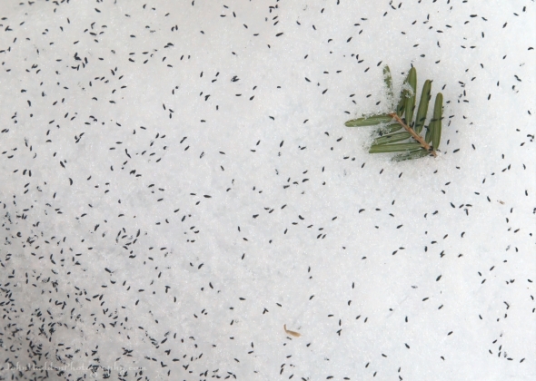 Snow fleas!
Morning Observation:
This morning in Huntington at 6:45AM it’s currently 35 degrees under clear skies. Winds are calm. Relative humidity is 87%, dewpoint 32, barometric pressure 29.97”. We have 4.5” of snow at the stake. Yesterday’s high was 48, and yesterday’s low was 24. The overnight low got down to 24.
This morning in North Hero it’s currently 37 degrees under clear skies. Winds are out of the south at 10-25 mph. Relative humidity is 75%, dewpoint 29, barometric pressure 29.94”. Yesterday’s high was 45, and yesterday’s low was 30. The overnight low got down to 30.
Forecast Discussion:
We’ve got us a bit of a roller-coaster ride ahead for the next 48 hours. High pressure cresting to our east today will continue our stretch of unseasonably warm weather as highs top out in the mid 50s today under clear skies and gusty south winds. Clouds will be on the increase later this afternoon out ahead of a potent storm system which will impact the region overnight tonight through Wednesday. Deep low pressure moving out of the Great Lakes tonight will track to our north and west during the day Wednesday. The low will lift a warm front into the region overnight tonight bringing scattered showers to the region overnight and into Wednesday morning. Temperatures are expected to surge to record-setting levels Wednesday with highs in the upper 50s to low 60s in broader valleys on gusty south winds. After a midday lull in precipitation, a sharp trailing cold front will cross the region Wednesday evening/night bringing renewed rain which may be heavy at times. With warm temperatures, heavy rains, high dewpoints, and gusty winds, snowmelt is expected to be significant leading to some river flooding. The NWS indicates areas of concern to be the Mad River in Moretown, and Otter Creek in Rutland on Thursday. Much colder air will move into the region overnight Wednesday into Thursday morning with overnight lows dropping into the teens. Some snow may accompany this transition, and flash freezing will be a concern as any pooling water quickly freezes. Dry and unseasonably chilly air will be in place for Thursday with highs only in the low 20s with gusty west winds. Once again, this cold air will be short-lived as a warming trend is expected heading into the weekend with highs in the low 40s Friday, upper 40s Saturday, and low 50s Sunday. Like I said, another roller-coaster…
3-Day Forecast:
We’ll see sunny skies today with a high near 55 and south winds 6-15 mph in Huntington and 23-26 mph in the Champlain Valley. Tonight should bring increasing clouds with scattered showers, mainly after 7:00APM. Lows will be around 46 with south winds 15-17 mph in Huntington and 22-26 mph over Lake Champlain. Chance of precipitation is 50% with rainfall amounts of less than 0.10″ possible.
Wednesday should be cloudy with showers likely, mainly after 4:00PM. Highs will be near 58 with south winds 14-23 mph in Huntington and 26-31 mph in the Champlain Valley gusting to 45 mph. Chance of precipitation is 70% with rainfall amounts between 0.10″-0.25″ possible. Wednesday night should be cloudy with rain showers before 11:00PM, then a chance of snow showers between 11:00PM and 1:00AM. Lows will be around 16 with southwest winds 25-30 mph becoming westerly after midnight. Winds could gust as high as 45 mph. Chance of precipitation is 80% with new snow accumulations of less than 0.50″ possible.
Thursday should be mostly sunny and chilly with a high near 21 and west winds 22-26 mph gusting to 41 mph. Thursday night should be partly cloudy with a low around 14 and northwest winds 16-21 mph decreasing to 7 to 12 mph after midnight.
Almanac:
Last year on this date in Huntington we had a high of 29 and a low of 17. We picked up 3.3″ of new snow and had 11″ at the stake.
Last year in North Hero we had a high of 24 and a low of 5. We had 5″ of snow at the stake.
Burlington averages for this date are a low of 18 and a high of 35.
The record low was -21 in 1963.
The record high was 57 in 2000 (we had a high of 61 in Huntington).
The Lake Champlain lake level in Burlington is 96.25′.
The water temperature is 35˚.
Last year’s lake level was at 96.26′.
The Mt. Mansfield snow stake depth is 58″.
The average depth for this date is 64″.
Mt. Washington Summit Conditions
Current Temperature: 24˚
Winds are out of the SW at 34 gusting to 45 mph
24 hr Precipitation: 0.6″ snow, 0.07″ melted precipitation
Visibility: around 80 miles under clear skies
Sky Notes:
Sunrise: 6:31AM
Sunset: 5:38PM
Length of day: 11:06:30
Today will be 3:00 longer than yesterday.
The Moon is waning gibbous, 17.2 days old with 93% illumination.
Moonrise: 8:54PM
Moonset: 7:49AM
About Today’s Photo:
We came across an outburst of snow fleas the other day while walking in the Jericho Town Forest. Snow fleas are not actually fleas, but rather a species of tiny springtail insects—Hypogastrura nivicola—that live and feed in the forest floor litter below the snow. When their populations reach a certain level, they’ll often erupt from under the snow near trees to crawl and jump on the snow. Snow fleas favor coniferous forests and we found these in stands of tall pine and hemlock.
Panasonic Lumix DS-SZ200, ISO 125, f/7.1, 1/1600″ exposure
Monday, February 26, 2024

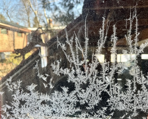 Window frost and reflections
Morning Observation:
This morning in Huntington at 7:20AM it’s currently 34 degrees under partly cloudy skies. Winds are calm. Relative humidity is 75%, dewpoint 27, barometric pressure 29.90”. We have 4.5” of snow at the stake. Yesterday’s high was 37, and yesterday’s low was 5. The overnight low got down to 32.
This morning in North Hero it’s currently 35 degrees under mostly cloudy skies. Winds are out of the south at 18-24 mph. Relative humidity is 77%, dewpoint 28, barometric pressure 29.88”. Yesterday’s high was 35, and yesterday’s low was 11. The overnight low got down to 32.
Forecast Discussion:
High pressure building into the region today will bring warming temperatures on a gusty southerly airflow with highs expected to bump into the mid 40s under partly sunny skies. After a seasonably mild night tonight, we’ll see highs on Tuesday in the mid 50 with increasing clouds out ahead of our next storm system. Low pressure tracking out of the Great Lakes later Tuesday night and to our north on Wednesday will lift a warm front through the region overnight and into Wednesday pushing temperatures into the mid to upper 50s and bringing widespread rain showers starting late Tuesday night and into Wednesday. After a midday lull in precipitation, a trailing cold front will swing through later Wednesday afternoon reinvigorating the rains which may become heavy at times. With warm temperatures, high dewpoints, and gusty winds, upper elevation snowmelt will become a concern as area rivers and streams begin to rise. A few snow showers may trail the cold front, but drier and sharply colder air is expected to move in behind the front dropping overnight lows Wednesday into the teens with highs on Thursday only in the mid 20s. High pressure will build in later Thursday and into the weekend with dry and unseasonably warm conditions expected for next weekend.
3-Day Forecast:
We’ll see partly sunny skies today with a high near 42 and south winds 8-16 mph becoming northwesterly in the afternoon. Tonight should be partly cloudy with a low around 28 and south winds 5-9 mph.
Tuesday should be mostly sunny with a high near 54 and south winds 10-15 mph in Huntington and 23-26 mph in the Champlain Valley. Tuesday night should be mostly cloudy with showers likely, mainly after 5:00AM. Lows will be quite mild—around 42—with south winds 14-17 mph in Huntington and 24-31 mph in the Champlain Valley. Chance of precipitation is 60% with rainfall amounts of less than 0.10″ possible.
Wednesday should be cloudy with showers. Highs will be near 56 with south winds 16-22 mph in Huntington and 24-29 mph gusting to 37 mph in the Champlain Valley. Chance of precipitation is 90% with rainfall amounts between 0.10″-0.25″ possible. Wednesday night should be cloudy with rain showers before 1:00AM, then a chance of snow showers. Lows will drop to around 18 with south winds 22-29 mph becoming westerly after midnight. Chance of precipitation is 100% with rainfall amounts between 0.25″-0.50″ possible.
Almanac:
Last year on this date in Huntington we had a high of 30 and a low of -4. We picked up 0.6″ of new snow and had 8″ at the stake.
Last year in North Hero we had a high of 30 and a low of 2. We picked up 1″ of new snow and had 4.5″ at the stake.
Burlington averages for this date are a low of 17 and a high of 35.
The record low was -19 in 1970.
The record high was 60 in 2002 (we had a high of 60 in Huntington).
The Lake Champlain lake level in Burlington is 96.24′.
The water temperature is 34˚.
Last year’s lake level was at 96.32″.
The Mt. Mansfield snow stake depth is 59″.
The average depth for this date is 64″.
Mt. Washington Summit Conditions
Current Temperature: 16˚
Winds are out of the NW at 54-60 mph
24 hr Precipitation: 1″ snow, 0.09″ melted precipitation
Visibility: less than 1/16 mile in freezing fog and blowing snow
Sky Notes:
Sunrise: 6:34AM
Sunset: 5:35PM
Length of day: 11:00:29
Today will be 2:59 longer than yesterday.
The Moon is waning gibbous, 16.4 days old with 97% illumination.
Moonrise: 7:51PM
Moonset: 7:34AM
About Today’s Photo:
I came across these nice window frost crystals on the way up my studio stairs yesterday morning. Bright reflections create multiple layers for the eye to linger upon.
iPhone 15 Pro
Sunday, February 25, 2024
 Mt. Mansfield from Underhill
Morning Observation:
This morning in Huntington at 7:05AM it’s currently 6 degrees under clear skies. Winds are calm. Relative humidity is 89%, dewpoint 3, barometric pressure 30.12”. We have a hard 5” of snow at the stake. Yesterday’s high was 30 (at midnight the previous night), and yesterday’s low was 5. The overnight low got down to 5.
This morning in North Hero it’s currently 17 under clear skies. Winds are out of the south at 14-16 mph. Relative humidity is 75%, dewpoint 10, barometric pressure 30.20”. Yesterday’s high was 26 ( (again at midnight the previous night), and yesterday’s low was 10. The overnight low got down to 11.
Forecast Discussion:
After a frigid start to the day, an increasingly southerly airflow will allow for temperatures to moderate back to more seasonable levels by this afternoon as high pressure over the region continues to pull away to the east. A weak trough is expected to swing through overnight tonight bringing a quick shot of precipitation tonight and into Monday with perhaps an inch or two of snow possible over northern mountains with some rain showers in broader valleys during the day Monday. A warming trend will continue through midweek with highs on Monday expected to be in the low 40s, low 50s Tuesday, and upper 50s on Wednesday. A more potent storm system will approach the region Tuesday night as low pressure tracks out of the Great Lakes and to our north lifting a warm front through the region Wednesday. Heavy rains are expected on Wednesday, and combined with strong winds and high dewpoints, mountain snowmelt will contribute to river rises later Wednesday into Thursday morning. A sharp cold front will swing through later Wednesday night allowing temperature to plummet back down into the low teens by Thursday morning. Some wraparound snow showers are possible by Thursday morning before drier air moves in on building high pressure, and temperatures warm once again above seasonal levels for next weekend.
3-Day Forecast:
We’ll see mostly sunny skies today with a high near 34 and south winds 5-10 mph in Huntington and 11-20 mph in the Champlain Valley. Tonight should be mostly cloudy with a 40% chance of snow showers, mainly after 11:00PM. Lows will be around 27 with south winds 11-14 mph in Huntington and 18-24 mph in the Champlain Valley. New snow accumulations of less than 0.50″ are possible.
Monday should start out cloudy with a chance of rain and snow showers. Skies should gradually become mostly sunny with a high near 41 and south winds 8-14 mph becoming northwesterly in the afternoon. Monday night should be mostly clear and mild with a low around 30 and light and variable winds becoming southeasterly 5-10 mph after midnight.
Tuesday should be partly sunny with a high near 52 and southeast winds 10-15 mph in Huntington and 24-26 mph in the Champlain Valley. Tuesday night should be mostly cloudy with a 50% chance of rain showers after 7:00PM. Lows will be around 42 with southeast winds 11-13 mph in Huntington and 17-21 mph in the Champlain Valley. Rainfall amounts of less than 0.10″ are possible.
Almanac:
Last year on this date in Huntington we had a high of 14 and a low of -11. We picked up 0.9″ of new snow and had 8″ at the stake.
Last year in North Hero we had a high of 12 and a low of -5. We had 4″ of snow at the stake.
Burlington averages for this date are a low of 17 and high of 34.
The record low was -17 in 1962.
The record high was 72 in 2017 (we had a high of 66 in Huntington).
The Lake Champlain lake level in Burlington is 96.35′.
The water temperature is 35˚.
Last year’s lake level was at 96.38′.
The Mt. Mansfield snow stake depth is 59′.
The average depth for this date is 62″.
Mt. Washington Summit Conditions
Current Temperature: 9˚
Winds are out of the NW at 32 mph
24 hr Precipitation: 0
Visibility: over 130 miles under clear skies.
Sky Notes:
Sunrise: 6:36AM
Sunset: 5:34PM
Length of day: 10:57:30
Today will be 2:59 longer than yesterday.
The Moon is waning gibbous, 15.5 days old with 99% illumination.
Moonrise: 6:49PM
Moonset: 7:17AM
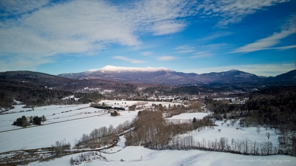
About Today’s Photo:
Here’s an aerial view of Mt. Mansfield taken from above Mill River Park in Underhill. A quintessential Vermont winter landscape.
DJI Mini 3 drone, ISO 100, f/1.7, 1/2000″ exposure
Saturday, February 24, 2024
 Frost “feathers” grow along Fargo Brook
Morning Observation:
This morning in Huntington at 7:25AM it’s currently 9 degrees under mostly clear skies. Winds are out of the northwest at 4-6 mph. Relative humidity is 74%, dewpoint 3, barometric pressure 29.78”. We have 5” of snow at the stake. Yesterday’s high was 48, and yesterday’s low was 30. The overnight low got down to 9.
This morning in North Hero it’s currently 13 degrees under mostly clear skies. Winds are out of the northwest at 6-8 mph. Relative humidity is 66%, dewpoint 3, barometric pressure 29.96”. Yesterday’s high was 45, and yesterday’s low was 26. The overnight low got down to 10.
Forecast Discussion:
We’ve got a chilly day on tap courtesy of a ridge of high pressure cresting over the region today. We’ll see highs today only in the low to mid teens with gusty northwest winds, and a cold night tonight as lows drop to either size of zero. The cold snap will be short-lived, however, as the ridge will move to our east overnight allowing for a southerly return flow to bring in warmer air for Sunday with highs expected to be back in the mid 30s with increasing afternoon clouds. A weak upper level shortwave will swing through the region overnight Sunday into Monday bringing some light snow/rain showers with highs on Monday expected to be in the mid 30s to mid 40s north to south. The warming trend will continue through much of next week with highs around 50 on Tuesday and nearing 60 on Wednesday. Unfortunately for snow lovers, this warmth will be accompanied by a potent storm system which will bring widespread potentially heavy rainfall to the region Tuesday night through Wednesday. We’ll have to keep our eye on rivers and streams later Wednesday as snowmelt will likely be high. Stay tuned…
3-Day Forecast:
We’ll see mostly sunny skies today with a high near 17 and north winds around 13 mph. Tonight should be mostly clear and cold with a low around 3 and north winds 5-10 mph becoming light and variable after midnight.
Sunday should bring increasing clouds with a high near 33 and south winds 5-11 mph. Sunday night should be cloudy with a 40% chance of snow showers after 10:00PM. Lows will be around 27 with south winds 11-14 mph in Huntington and 18-14 in the Champlain Valley. New snow accumulations of less than 0.50″ are possible.
Monday should start off cloudy with a 30% chance of morning snow showers. Skies should gradually become mostly sunny with a high near 42 and south winds 8-114 mph becoming westerly in the afternoon. Monday night should be partly cloudy with a low around 25 and north winds 5-10 mph becoming southeasterly after midnight.
Almanac:
Last year on this date in Huntington we had a high of 20 and a low of -6. We picked up 1.6″ of new snow and had 8.5″ at the stake.
Last year in North Hero we had a high of 19 and a low of 4. We picked up 1″ of new snow and had 5″ at the stake.
Burlington averages for this date are a low of 17 and a high of 34.
The record low was -19 in 2015 (we had a low of -20 in Huntington).
The record high was 53 in 1984.
The Lake Champlain lake level in Burlington is 96.45′.
The water temperature is 36˚.
Last year’s lake level was at 96.43′.
The Mt. Mansfield snow stake depth is 59″.
The average depth for this date is 62″.
Mt. Washington Summit Conditions
Current Temperature: 2˚
Winds are out of the north at 52-57 mph
24 hr Precipitation: 0.4″ snow, 0.04″ melted precipitation
Visibility: less than 1/16 mile in freezing fog and blowing snow
Sky Notes:
Sunrise: 6:38AM
Sunset: 5:32PM
Length of day: 10:54:30
Today will be 2:58 longer than yesterday.
The Moon is the full “Snow” moon (Northeast Native American), 14.6 days old with 100% illumination.
Moonrise: 5:46PM
Moonset: 7:00AM
About Today’s Photo:
Here’s another icy crystal shot for you. The open water of Fargo Brook offers ample super-cooled moisture that bumps into objects to forms these delicate hoarfrost “feathers”. They can range anywhere from 0.5″ to 2″ in length, and the slightest breeze or bump sends them crashing.
Sony A7II, Sony 90mm macro lens, ISO 400, f/13, 1/320″ exposure
Friday, February 23, 2024

 Frost crystals form flowers on dried seed head
Morning Observation:
This morning in Huntington at 7:30AM it’s currently 36 degrees under cloudy skies. Winds are calm. Relative humidity is 94%, dewpoint 34, barometric pressure 29.92”. We picked up 0.05” of rain yesterday and 0.08” so far today. We have 6” of snow at the stake. Yesterday’s high was 44, and yesterday’s low was 32. The overnight low got down to 34.
This morning in North Hero it’s currently 35 degrees under cloudy skies. Winds are out of the south at 10-15 mph. Relative humidity is 95%, dewpoint 34, barometric pressure 29.55”. We picked up 0.01” of rain yesterday and are down to bare ground at the stake. Yesterday’s high was 37, and yesterday’s low was 32. The overnight low got down to 35.
Forecast Discussion:
Morning radar imagery shows a line of rain and snow showers extending along a stalled occluded front stretching from about NYC, up through central Vermont, and into Maine. This frontal boundary is expected to creep southeastward today bringing any remaining showers to an end during the day. Highs today will top out in the low to mid 40s. A sharp cold front is expected to cross the region overnight tonight causing temperatures to plummet from their afternoon highs into the single digits and low teens by daybreak on Saturday. Some snow showers way accompany the frontal passage overnight. Some of the coldest air of the season will move in behind the front for Saturday on a ridge of high pressure with daytime highs only expected to be in the low to mid teens and overnight lows dropping into the single digits Saturday night with gusty northwest winds. The cold air won’t be with us long, however, as the ridge moves to our east allowing for a southerly return flow to set up Sunday bringing in milder air with highs in the mid 30 expected for Sunday. A weak trough will swing through Sunday night into Monday bringing a chance of some light snow showers, but the warming trend will continue with highs expected to be in around 40 on Monday, 50 and Tuesday, and approaching 60 by Wednesday. A more significant storm system is expected to develop in the Wednesday/Thursday timeframe as a “full latitude” trough (one that stretches all the way from southern latitudes to northern latitudes) crosses the region bringing widespread rain. Stay tuned…
3-Day Forecast:
We’ll see mostly cloudy skies today with a slight chance of morning snow showers, then a slight chance of evening rain showers. Highs will be near 45 with south winds 5-12 mph. Tonight should be mostly cloudy with a 50 percent% chance of snow showers. Lows will be around 9 with north winds 8-16 mph. New snow accumulations of less than 0.50″ are possible.
Saturday should be mostly sunny and chilly with a high near 16 and northwest winds 14-17 mph. Saturday night should be mostly clear with a low around 6 and northwest winds 6-11 mph becoming light and variable after midnight.
Sunday should be mostly sunny with a high near 33 and south winds 5-10 mph. Sunday night should be cloudy with a 50% chance of snow showers. Lows will be around 28 with south winds around 11 mph.
Almanac:
Last year on this date in Huntington we had a high of 25 and a low of 19. We picked up 4.7″ of new snow and had 7.5″ at the stake.
Last year in North Hero we had a high of 20 and a low of 14. We picked up 4″ of new snow and had 4″ at the stake.
Burlington averages for this date are a low of 16 and a high of 34.
The record low was -22 in 1972.
The record high was 63 in 2017 (we had a high of 64 in Huntington).
The Lake Champlain lake level in Burlington is 96.46′.
The water temperature is 35˚.
Last year’s lake level was at 96.44′.
The Mt. Mansfield snow stake depth is 60″.
The average depth for this date is 61″.
Mt. Washington Summit Conditions
Current Temperature: 25˚
Winds are out of the NE at 11-13 mph
24 hr Precipitation: 1.2″ snow, 0.13″ melted precipitation
Visibility: less than 1/16 mile in freezing fog
Sky Notes:
Sunrise: 6:39AM
Sunset: 5:31PM
Length of day: 10:51:32
Today will be 2:57 longer than yesterday.
The Moon is waxing gibbous, 13.7 days old with 98% illumination.
Moonrise: 4:42PM
Moonset: 6:40AM
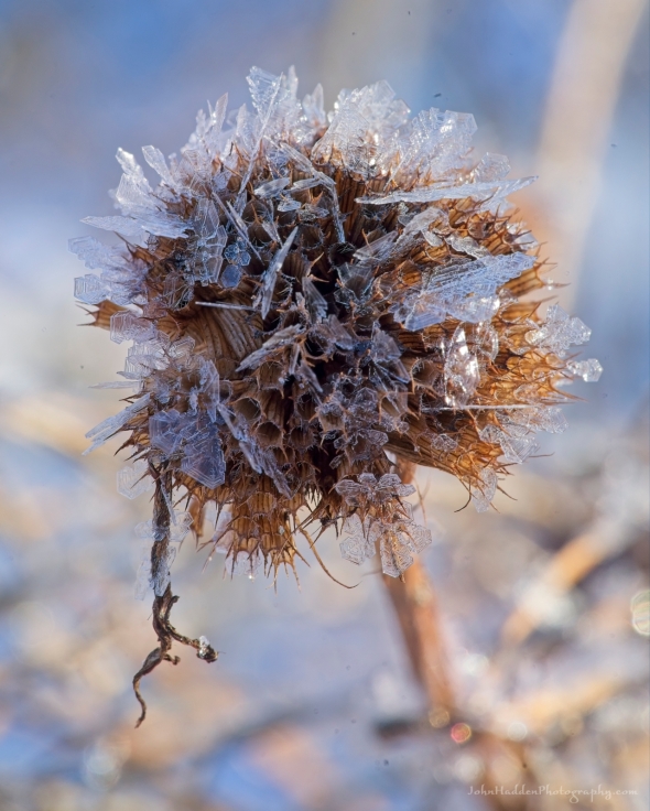
About Today’s Photo:
Here’s another shot from our glittery chilly morning the other day. Frost crystals have formed almost flower-like shapes on the dried seed head of a shrub by our pond. I meant to mention yesterday that we coincidentally visited the Snowflake Bentley Museum in Jericho the other day. I’d never been before and it was wonderful to learn a bit about this pioneering photographer and see some of is amazing prints of snowflakes.
Sony A7II, Sony 90mm macro lens, ISO 400, f/5.6, 1/250″ exposure
Thursday, February 22, 2024

 Delicate frost crystal decorate a dried bee balm seed head
Morning Observation:
This morning in Huntington at 6:55AM it’s currently 34 degrees under partly cloudy skies. Winds are calm. Relative humidity is 72%, dewpoint 26, barometric pressure 29.96”. We have 7.5” of snow at the stake. Yesterday’s high was 43, and yesterday’s low was 8. The overnight low got down to 32.
This morning in North Hero it’s currently 33 degrees under partly cloudy skies. Winds are out of the south at 22-26 mph. Relative humidity is 78%, dewpoint 26, barometric pressure 29.95”. We’re pretty much down to bare ground at the snow stake. Yesterday’s high was 39, and yesterday’s low was 19. The overnight low got down to 32.
Forecast Discussion:
We’ve got a bit of a roller-coaster ride ahead of us for the next 48-72 hours. Warm air continues to move into the region this morning out ahead of weak low pressure to our west. We’ll see increasing clouds today with highs once again in the upper 30s to low 40s with gusty south winds. Precipitation is expected to move into the region later this afternoon, starting as scattered rain showers, then transitioning to mixed precipitation and snow overnight as temperatures drop to around freezing. We may see a dusting to a couple of inches of snow over the higher terrain/summits of the Greens and ‘Dacks by Friday morning before precipitation changes back to rain through day on Friday as highs top out in the low 40s. A sharp cold front will then cross the region later Friday evening and overnight allowing temperatures to plummet into the single digits either side of zero overnight as a quick blast of Arctic air moves in. Saturday’s lining up to be a frigid day with highs only in the teens with gusty northwest winds. But wait! Just a quickly as the cold air moved in Friday night, warmer air will rush back into the region on Sunday as winds shift back into the south and highs rise into the mid 30s under partly sunny skies. A weak frontal boundary is expected to cross the region on Monday bringing light valley rain and upper elevation snow showers. A warming trend is expected to build into the middle of the week with highs approaching 50 degrees by Wednesday. A more significant storm system appears to be on the horizon for next Wednesday/Thursday with a near full latitude trough crossing the central US bringing the potential for widespread heavy rain to the region. Stay tuned…
3-Day Forecast:
We’ll see mostly cloudy skies today with a high near 42 and south winds 10-13 mph in Huntington and 22-26 mph in the Champlain Valley. Tonight should be cloudy with rain and snow likely. Lows will be around 34 with south winds around 10-20 mph. Chance of precipitation is 70% with little or no snow accumulation expected.
Friday should be cloudy with a chance of rain and snow showers in the morning, then a chance of rain showers. Highs will be near 41 with south winds 5-12 mph. Chance of precipitation is 50% with little or no snow accumulation expected. Friday night should be mostly cloudy with a 40% chance of snow showers before 2:00AM. Lows will be around 8 with northwest winds 8-13 mph. New snow accumulations of less than 0.50″ are possible.
Saturday should become gradually sunny, with a high near 15 and northwest winds 11-13 mph. Saturday night should be mostly clear with a low around 5 and northwest winds 6-10 mph.
Almanac:
Last year on this date in Huntington we had a high of 34 and a low of 17. We picked up 0.25″ of new snow and had 3″ at the stake.
Last year in North Hero we had a high of 36 and a low of 19.
Burlington averages for this date are a low of 16 and a high of 33.
The record low was -20 in 1963.
The record high was 61 in 1981.
The Lake Champlain lake level in Burlington is 96.44′.
The water temperature is 35˚.
Last year’s lake level was at 96.42′.
The Mt. Mansfield snow stake depth is 61″.
The average depth for this date is 61″.
Mt. Washington Summit Conditions
Current Temperature: 18˚
Winds are out of the west at 34-37 mph
24 hr Precipitation: 0
Visibility: around 70 miles under partly cloudy skies.
Sky Notes:
Sunrise: 6:41AM
Sunset: 5:30PM
Length of day: 10:48:34
Today will be 2:57 longer than yesterday.
The Moon is waxing gibbous, 12.8 days old with 95% illumination.
Moonrise: 3:36PM
Moonset: 6:16AM
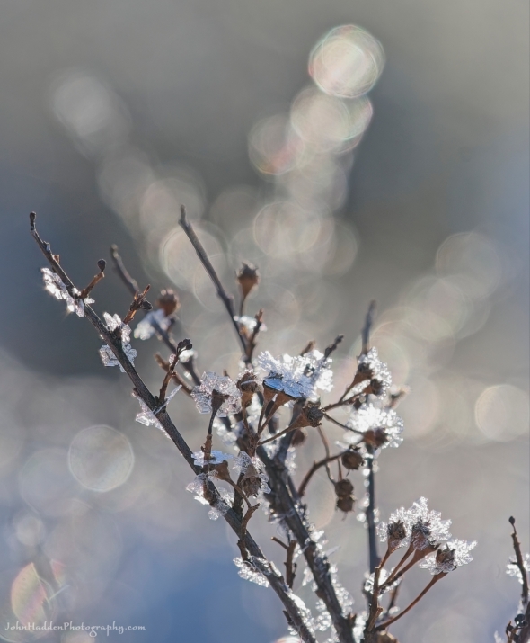
About Today’s Photo:
Yesterday morning’s chilly temperatures made perfect conditions for the development of delicate ice crystal frost. Many of the trees and shrubs along Fargo Brook were glittering with a shiny coating as the sun rose. This bee balm seed head held some gorgeous crystals.
bSony A7II, Sony 90mm macro lens, ISO 800, f/13, 1/40″ exposure
Wednesday, February 21, 2024
 Many forms of ice on a tall cliff up at CHNSA
Morning Observation:
This morning in Huntington at 6:55AM it’s currently 11 degrees under clear skies. Winds are calm. Relative humidity is 90%, dewpoint 9, barometric pressure 30.46”. We have 8.5” of snow at the stake. Yesterday’s high was 31, and yesterday’s low was -2. The overnight low got down to 8.
This morning in North Hero it’s currently 22 degrees under clear skies. Winds are out of the south at 5-8 mph. Relative humidity is 80%, dewpoint 17, barometric pressure 30.49”. We have 1” of snow at the stake. Yesterday’s high was 22, and yesterday’s low was 10. The overnight low got down to 19.
Forecast Discussion:
High pressure sliding to our east will bring an increasing southerly airflow today allowing temperatures to rise into the upper 30s to low 40s with gusty south winds and clear skies today. After a seasonably mild night tonight, a warm front will push through the region on Thursday bringing some scattered rain/snow showers later in the day with more widespread precipitation expected overnight and into Friday as temperatures remain near or above freezing overnight. We’ll have two fronts to deal with on Friday, the first being a warm front that will bring increasing chances for rainfall during the day, followed by a sharp cold front which will cross the region Friday night dropping temperatures quickly overnight. Some flash freezing is possible overnight. Much colder air will be in place for Saturday and Saturday night before more seasonable conditions arrive Sunday with a warming trend expected heading into next week.
3-Day Forecast:
We’ll see sunny skies today with a high near 39 and south winds 8-11 mph in Huntington and 17-24 mph in the Champlain Valley. Tonight should be partly cloudy with a low around 25 and south winds around 10 mph in Huntington and 23-26 mph in the Champlain Valley.
Thursday should be partly sunny with a high near 43 and south winds around 9 mph. Thursday night should be cloudy with rain and snow showers likely, becoming all snow after 3:00AM. Lows will be around 33 with south winds 8-16 mph. Chance of precipitation is 60% with little or no snow accumulation expected.
Friday should be cloudy with snow showers likely before 8:00AM, then rain showers likely after 9:00AM. Highs will be near 40 with south winds 6-10 mph becoming southwesterly in the afternoon. Chance of precipitation is 70%. Friday night should be cloudy with snow showers likely, mainly before 7:00PM. Lows will be around 7 with northwest winds 10-15 mph. Chance of precipitation is 60%.
Almanac:
Last year on this date in Huntington we had a high of 42 and a low of 17. We had 3″ of snow at the stake.
Last year in North Hero we had a high of 39 and a low of 14. Bare ground at the stake.
Burlington averages for this date are a low of 16 and a high of 33.
The record low was -19 in 1950.
The record high was 69 in 2018 (we had a high of 70 in Huntington!)
The Lake Champlain lake level in Burlington is 96.60′.
The water temperature is 35˚.
Last year’s lake level was at 96.42′.
The Mt. Mansfield snow stake depth is 63″.
The average depth for this date is 61″.
Mt. Washington Summit Conditions
Current Temperature: 12˚
Winds are out of the west at 13-16 mph
24 hr Precipitation: 1.6″ snow, 0.17″ melted precipitation
Visibility: around 80 miles under clear skies
Sky Notes:
Sunrise: 6:43AM
Sunset: 5:28PM
Length of day: 10:45:37
Today will be 2:56 longer than yesterday.
The Moon is waxing gibbous, 12 days old with 91% illumination.
Moonrise: 2:29PM
Moonset: 5:45AM
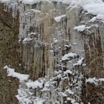
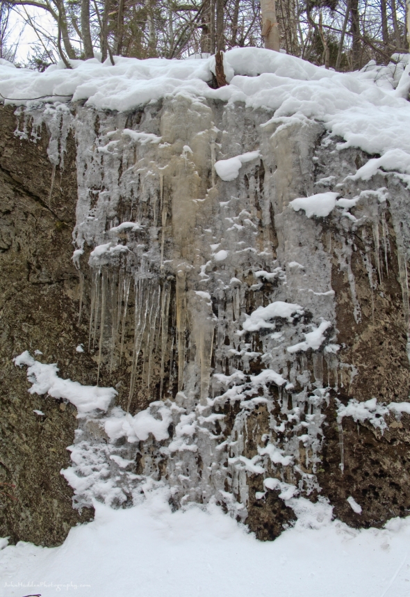
About Today’s Photo:
I did some exploring off piste at Camel’s Hump Nordic yesterday. There’s a spot that’s tucked in to a circle of tall cliffs where ice has formed along some of the faces. I found the variety of ice forms to be quite interesting.
Panasonic Lumix DS-SZ200, ISO 125, f/8, 1/80″ exposure
Tuesday, February 20, 2024

 A morning visitor on one of our camp cameras
Morning Observation:
This morning in Huntington at 7:05AM it’s currently 7 degrees under cloudy skies. Winds are calm. Relative humidity is 89%, dewpoint 5, barometric pressure 30.47”. We have 9” of snow at the stake. Yesterday’s high was 26, and yesterday’s low was 0. The overnight low got down to -2.
This morning in North Hero it’s currently 16 degrees under cloudy skies. Winds are calm. Relative humidity is 82%, dewpoint 11, barometric pressure 30.56”. We have 1” of snow at the stake. Yesterday’s high was 27, and yesterday’s low was 11. The overnight low got down to 10.
Forecast Discussion:
After a chilly start to the day, morning clouds are expected to give way to partly or mostly sunny skies today as high pressure continues its hold over the region. We’ll see highs today bump up into the upper 20s with light winds. The ridge of high pressure will shift to our east overnight tonight setting up a southerly airflow allowing for temperatures to bump up into the upper 30s under sunny skies Wednesday and low 40s on Thursday with gusty south winds. Clouds will be on the increase Thursday out ahead of our next storm system. Disorganized low pressure will bring widespread rain to the region during the day on Friday. A sharp cold front is expected to cross the region later Friday evening/night bringing a rapid drop in temperatures along with a bit of wrap up snow. Stay tuned…
3-Day Forecast:
We’ll see partly sunny skies today with a high near 29 and light and variable winds. Tonight should be mostly clear with a low around 15 and south winds 5-10 mph.
Wednesday should be sunny and unseasonably warm with a high near 39 and south winds 8-11 mph in Huntington and 21-25 mph over Lake Champlain. Wednesday night should be partly cloudy with a low around 25 and south winds 8-10 mph in Huntington and 20-23 mph over Lake Champlain.
Thursday should be mostly cloudy with a high near 42 and south winds 10-20 mph. Thursday night should be cloudy with a 50% chance of rain and snow showers. Lows will be around 33 with south winds 9-15 mph. Rainfall amounts of less than 0.10″ are possible.
Almanac:
Last year on this date in Huntington we had a high of 44 and a low of 28. We had 4″ of snow at the stake.
Last year in North Hero we had a high of 42 and a low of 24. We were down to bare ground at the stake.
Burlington averages for this date are a low of 15 and a high of 33.
The record low was -13 in 1968.
The record high was 59 in 2018 (we had a high of 50 in Huntington).
The Lake Champlain lake level in Burlington is 96.68′.
The water temperature is 35˚.
Last year’s lake level was at 96.39′.
The Mt. Mansfield snow stake depth is 64″.
The average depth for this date is 61″.
Mt. Washington Summit Conditions
Current Temperature: -5˚
Winds are out of the north at 70 gusting to 82 mph.
24 hr Precipitation: 0.2″ snow, 0.03″ melted precipitation
Visibility: around 1/16 mile with freezing fog and blowing snow
Sky Notes:
Sunrise: 6:44AM
Sunset: 5:27PM
Length of day: 10:42:41
Today will be 2:55 longer than yesterday.
The Moon is waxing gibbous, 11 days old with 84% illumination.
Moonrise: 1:23PM
Moonset: 5:07AM
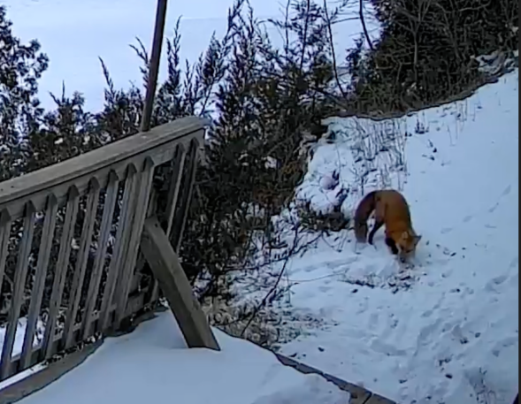
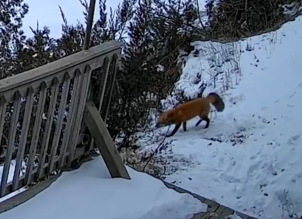
About Today’s Photo:
I just happened to check out our lake camera this morning when this playful fox was cavorting in the snow by the lake. I managed to get a short video of the fox. The photo is a screenshot of a blown-up video, so the quality it’s up to my usual snuff, but I wanted to share it anyway as it’s quite a lovely beast! I pointed out fox tracks in yesterday’s post right in the same location, so here’s the likely critter responsible! Check out the tail in the snippet below:
Monday, February 19, 2024
 Fanciful ice along our camp cabin eve
Morning Observation:
This morning in Huntington at 7:30AM it’s currently 13 degrees under partly cloudy skies. Winds are calm. Relative humidity is 73%, dewpoint 6, barometric pressure 30.10”. We picked up 1” of snow fluff overnight and have 10” at the stake. Yesterday’s high was 28, and yesterday’s low was 4. The overnight low got down to 13.
This morning in North Hero it’s currently 15 degrees under partly cloudy skies. Winds are calm. Relative humidity is 70%, dewpoint 7, barometric pressure 30.20”. We picked up about 0.5” of new snow and have 2” at the stake. Yesterday’s high was 30, and yesterday’s low was 12. The overnight low got down to 15.
Forecast Discussion:
A cold front dropped through the region overnight last night bringing some quick snow flurries and squalls to the region. Much colder air has moved in behind the front on building high pressure which will dominate our weather through much of this week. We’ll see clearing skies today through midweek. Highs today will only be in the low 20s with gusty northwest winds, and overnight lows tonight will be the coldest of the period with lows dropping into the single digits either side of zero for much of the region outside of the Champlain Valley. A warming trend is expected midweek as winds turn into the south pushing highs up to around 40 Wednesday through Friday. Our next storm system arrives late Thursday night into Friday. Forecast models aren’t showing much agreement at this time regarding the evolution of this system, but the general idea is that we’ll see periods of valley rain and mountain snow Thursday night with precipitation changing over to all rain by Friday. This looks to be a fairly progressive system—moving through the region quickly—and colder air is expected to move in behind the departing system Friday night bringing some wrap-up snow showers.
3-Day Forecast:
We’ll see mostly sunny skies today with a high near 21 and northwest winds 10-15 mph. Tonight should be partly cloudy with a low around 6 and northwest winds 5-10 mph.
Tuesday should be sunny with a high near 27 and light and variable winds. Tuesday night should be mostly clear with a low around 14 and southeast winds 5-7 mph.
Wednesday should be sunny with a high near 39 and south winds 8-10 mph in Huntington and 17-20 over Lake Champlain. Wednesday night should be partly cloudy with a low around 25 and south winds 9-18 mph.
Almanac:
Last year on this date in Huntington we had a high of 44 and a low of 28. We had 4″ of snow at the stake.
Last year in North Hero we had a high of 42 and a low of 32. We had 1″ of snow at the stake.
Burlington averages for this date are a low of 15 and a high of 33.
The record low was -23 in 1944.
The record high was 62 in 1981.
The Lake Champlain lake level in Burlington is 96.72′.
The water temperature is 34˚.
Last year’s lake level was at 96.44′
The Mt. Mansfield snow stake depth is 61″.
The average depth for this date is 61″.
Mt. Washington Summit Conditions
Current Temperature: -7˚
Winds are out of the north at 62 gusting to 73 mph
24 hr Precipitation: 2.8″ snow, 0.25″ melted precipitation
Visibility: less than 1/16 mile in freezing fog and blowing snow
Sky Notes:
Sunrise: 6:46AM
Sunset: 5:26PM
Length of day: 10:39:45
Today will be 2:54 longer than yesterday.
The Moon is waxing gibbous, 10 days old with 76% illumination.
Moonrise: 12:22PM
Moonset: 4:17AM
About Today’s Photo:
Checking our camp cameras this morning revealed an interesting phenomena. The interiors of our uninsulated cabins is quickly warmed by any sunshine allowing for the snow on the metal roofs to melt and refreeze along the eves. A repeated freeze/thaw cycle led to these interesting hanging ice teeth. Note the fox tracks along the left of the photo as someone prowled the shoreline early this morning.
Wyze Cam photo
Sunday, February 18, 2024

 Clearing skies and snow covered ice in North Hero
Morning Observation:
This morning in Huntington at 7:25AM it’s currently 15 degrees under cloudy skies. Winds are calm. Relative humidity is 84%, dewpoint 11, barometric pressure 29.73”. We picked up 3.5” of new snow during the day yesterday and have 10” at the stake. Yesterday’s high was 26, and yesterday’s low was 11. The overnight low got down to 4.
This morning in North Hero it’s currently 19 degrees under cloudy skies. Winds are out of the south at 15-16 mph. Relative humidity is 84%, dewpoint 15, barometric pressure 29.79”. We have 3” of snow at the stake. Yesterday’s high was 32, and yesterday’s low was 13. The overnight low got down to 12.
Forecast Discussion:
An Arctic boundary will drop into the region later this evening/overnight bringing a quick round of snow showers with some embedded snow squalls overnight. We may pick up an inch or two here in Huntington. Cool and dry air will move in behind the front bringing a stretch of seasonable, dry, and mostly sunny weather for the first part of the week under building high pressure. A warming trend is expected to develop by midweek with highs on Wednesday and Thursday pushing into the mid 40s. Our next storm system will arrive sometime later Thursday into Friday bringing another round of mixed precipitation to the region. It’s still too far out to get an exact bead on precipitation types and amounts, but at this point it’s not looking like a washout. Colder air is expected to move in behind the system. Stay tuned…
3-Day Forecast:
We’ll see mostly cloudy skies today with a 20% chance of snow showers. Highs will be near 29 with southwest winds 10-16 mph. Tonight should be mostly cloudy with a 50% chance of snow showers. Lows will be around 14 with southwest winds 11-16 mph becoming northwesterly after midnight. New snow accumulations of less than 1″ are possible.
Monday should be sunny with a high near 23 and northwest winds 9-11 mph. Monday night should be mostly clear and chilly with a low around 8 and northwest winds 5-7 mph becoming calm after midnight.
Tuesday should be sunny with a high near 31 and light and variable winds. Tuesday night should be partly cloudy with a low around 16 and southeast winds around 6 mph in the evening.
Almanac:
Last year on this date in Huntington we had a high of 31 and a low of 6. We picked up 1.5″ of new snow and had 4.5″ at the stake.
Last year in North Hero we had a high of 34 and a low of 12. We picked up 1″ of new snow and had 1″ at the stake.
Burlington averages for this date are highs of 15 and a high of 32.
The record low was -25 in 1979.
The record high was 58 in 1981.
The Lake Champlain lake level in Burlington is 96.80′.
The water temperature is 35˚.
Last year’s lake level was at 96.42′.
The Mt. Mansfield snow stake depth is 61″.
The average depth for this date is 61″.
Mt. Washington Summit Conditions
Current Temperature: -8˚
Winds are out of the north at 58-61 mph
24 hr Precipitation: 2.9″ snow, 0.25″ melted precipitation
Visibility: around 1/16 mile in freezing fog and blowing snow
Sky Notes:
Sunrise: 6:47AM
Sunset: 5:24PM
Length of day: 10:36:50
Today will be 2:53 longer than yesterday.
The Moon is waxing gibbous, 9 days old with 67% illumination.
Moonrise: 11:28AM
Moonset: 3:17AM
About Today’s Photo:
The weather in North Hero was very different yesterday than it was here in Huntington. While Huntington experienced some persistent snow showers during the day, North Hero enjoyed a mostly sunny day with gusty west winds—perfect for Great Ice festivities! We could see the snow falling over the mountains during the day. Such is the weather in Vermont.
iPhone 15 Pro
Saturday, February 17, 2024

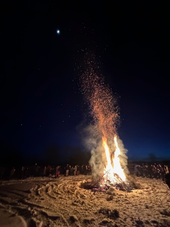 Sparks fly to the moon at the North Hero Great Ice bonfire
Morning Observation:
This morning in North Hero at 7:50AM it’s currently 20 degrees and snowing lightly under overcast skies. Winds are calm. Relative humidity is 93%, dewpoint 18, barometric pressure 29.85”. We picked up 0.75” of new snow so far today and have 4.5” at the stake (we picked up 4” overnight Thursday into Friday). Yesterday’s high was 30, and yesterday’s low was 20. The overnight low got down to 19.
This morning in Huntington it’s currently 20 degrees under cloudy skies. Winds are calm. Relative humidity is 94%, dewpoint 19, barometric pressure 29.76”. We picked up 3.5” of new snow during the day yesterday and have 10.5” of snow at the stake. Yesterday’s high was 29, and yesterday’s low was 17. The overnight low got down to 17.
Forecast Discussion:
A shortwave trough swinging through the region is bringing scattered snow showers to the Vermont this morning which will continue on-and-off through the day, eventually winding down from west to east. We should pick up an inch or two of fresh snow from this system. Some showers could linger into tonight. Another shortwave trough is expected to drop into the region later on Sunday bringing another round of snow showers and possible squall-like conditions at times in heavier snow bands. Mountain locations could pick up another 3″ of fresh snow overnight Sunday while valley locations see maybe 0.50″-1″. A cold front will drop through the region by Monday morning bringing dry conditions and some sunshine by Monday afternoon. Quiet and mostly sunny conditions are expected for the first half of next week before a warmup arrives by Wednesday when highs could bump into the mid 40s. Our next chance of precipitation arrives sometime Thursday into Friday, and at this point it’s looking like another mixed bag system.
3-Day Forecast:
We’ll see mostly cloudy skies today with snow showers likely, mainly before noon. Highs will be near 24 with northwest winds 5-9 mph. Chance of precipitation is 70% with snow accumulations of 1″-2″ possible. Tonight should be mostly cloudy with a 30% chance of snow showers, mainly before 11:00PM. Lows will be around 9 with northwest winds 6-8 mph becoming southerly after midnight.
Sunday should be mostly cloudy with a 40% chance of afternoon snow showers. Highs will be near 30 with south winds 11-18 mph. New snow accumulations of less than 0.50″ are possible. Sunday night should be mostly cloudy with snow showers likely. Lows will be around 15 with southwest winds 11-15 mph becoming westerly after midnight. Chance of precipitation is 60% with new snow accumulations of less than 1″ possible.
Monday should be mostly sunny with a high near 25 and northwest winds 8-10 mph. Monday night should be partly cloudy with a low around 8 and northwest winds around 6 mph becoming calm in the evening.
Almanac:
Last year on this date in Huntington we had a high of 36 and a low of 15. We picked up 0.06″ of rain and had 3″ of snow at the stake.
Last year in North Hero we had a high of 34 and a low of 18. No snow.
Burlington averages for this date are a low of 15 and a high of 32.
The record low was -21 in 1963.
The record high was 53 in 1981.
The Lake Champlain lake level in Burlington is 96.89′.
The water temperature is 35˚.
Last year’s lake level was at 96.36′.
The Mt. Mansfield snow stake depth is 58″.
The average depth for this date is 61″.
Mt. Washington Summit Conditions
Current Temperature: 0˚
Winds are out of the west at 25 mph
24 hr Precipitation: 3″ snow, 0.26″ melted precipitation
Visibility: around 1/16 mile in freezing fog.
Sky Notes:
Sunrise: 6:49AM
Sunset: 5:23PM
Length of day: 10:33:56
Today will be 2:52 longer than yesterday.
The Moon is waxing gibbous, 8 days old with 58% illumination.
Moonrise: 10:43AM
Moonset: 2:12AM
About Today’s Photo:
We spent last night up here in North Hero attending the annual North Hero Great Ice Festival. This is our first time spending the night for the event, and we enjoyed the huge Christmas Tree bonfire and then some really great fireworks. Luckily there was just enough ice for the Festival to set its skating oval and rink, and many people were enjoying the ice. In years past, we’ve helped out with the walk-across-the-ice to Knight Island, but, unfortunately, the ice isn’t safe for it this year.
 The lighted skating oval and rink
Friday, February 16, 2024

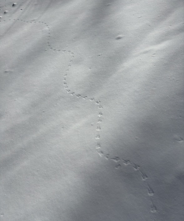 Meandering mouse tracks in the snow
Morning Observation:
This morning in Huntington at 7:10AM it’s currently 19 degrees and snowing lightly under overcast skies. Winds are calm. Relative humidity is 90%, dewpoint 17, barometric pressure 29.72”. We picked up 3.3” of fluffy new snow and have 8” at the stake. Yesterday’s high was 29, and yesterday’s low was 5. The overnight low got down to 19.
This morning in North Hero it’s currently 21 degrees and snowing lightly under overcast skies. Winds are calm. Relative humidity is 96%, dewpoint 20, barometric pressure 29.81”. I don’t know how much snow fell as my cameras are currently down. Yesterday’s high was 29, and yesterday’s low was 15. The overnight low got down to 20.
A Winter Weather Advisory remains in effect for our region until 1:00PM this afternoon.
Forecast Discussion:
Snow showers are expected to wind down this morning with some lingering snow showers becoming terrain driven over the northern Greens and ‘Dacks where an inch or two more snow may fall. Seasonable but blustery conditions are expected for the rest of the day today with highs in the upper 20s and gusty northwest winds. A clippers system will pass to our south on Saturday bringing the chance of some light snow to the region during the day Saturday. A second weak shortwave will pass to our north on Sunday bringing the chance of some snow Sunday as well. Dry and seasonable conditions are expected to begin next week with a warming trend expected midweek into the end of the week. The next chance of precipitation arrives sometime Thursday and at this point it’s looking like another wintery mix of precipitation. Stay tuned…
3-Day Forecast:
We’ll see cloudy skies today with snow showers mainly before 10:00AM. Highs will be near 28 with northwest winds 10-15 mph gusting to 25 mph. Chance of precipitation is 80% with new daytime snow accumulations of less than 1″ possible. Tonight should be mostly cloudy with a slight chance of snow showers before 9:00PM. Lows will be around 18 with west winds 5-9 mph becoming calm after midnight.
Saturday should be partly sunny with a 30% chance of snow showers. Highs will be near 26 with northwest winds 5-10 mph. Saturday night should be mostly cloudy with a 30% chance of snow showers before midnight. Lows will be around 11 with northwest winds 5-7 mph becoming southwesterly after midnight.
Sunday should be mostly cloudy with a 50% chance of afternoon snow showers. Highs will be near 28 with south winds 7-10 mph in Huntington and 16-20 mph over Lake Champlain. New snow accumulations of less than 0.50″ are possible. Sunday night should be mostly cloudy with a 40% chance of snow showers. Lows will be around 18 with southwest winds 10-16 mph becoming westerly after midnight.
Almanac:
Last year on this date in Huntington we had a high of 51 and a low of 32. We had 4″ of snow at the stake.
Last year in North Hero we had a high of 52 and a low of 34. We were down to bare ground at the stake.
Burlington averages for this date are a low of 14 and a high of 32.
The record low was -29 in 1943.
The record high was 56 in 2023 (see above).
The Lake Champlain lake level in Burlington is 96.98′.
The water temperature is 36˚.
Last year’s lake level was at 96.31′.
The Mt. Mansfield snow stake depth is 50″.
The average depth for this date is 60″.
Mt. Washington Summit Conditions
Current Temperature: 3˚
Winds are out of the north at 66 gusting to 78 mph
24 hr Precipitation: 2.5″ snow, 0.18″ melted precipitation
Visibility: less than 1/16 mile in blowing snow and freezing fog.
Sky Notes:
Sunrise: 6:50AM
Sunset: 5:21PM
Length of day: 10:31:03
Today will be 2:51 longer than yesterday.
The Moon is in its first quarter, 7 days old with 47% illumination.
Moonrise: 10:09AM
Moonset: 12:54AM
About Today’s Photo:
I went for a long ski up at Camel’s Hump Nordic yesterday morning and noted that there was a lot of rodent activity evident in the fresh snow. This meandering mouse track caught my eye as the mouse didn’t seem to have a straight course in mind! Note the tail-drag as the mouse moves towards the camera.
iPhone 15 Pro
Thursday, February 15, 2024
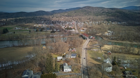 Portrait of a Richmond village
Morning Observation:
This morning in Huntington at 8:00AM it’s currently a chilly 7 degrees under clear skies. Winds are calm. Relative humidity is 90%, dewpoint 4, barometric pressure 30.19”. We have 5” of snow at the stake. Yesterday’s high was 29, and yesterday’s low was 13. The overnight low got down to 5.
This morning in North Hero it’s currently 26 degrees under clear skies (the morning sun is going work…) Winds are calm. Relative humidity is 55%, dewpoint 12, barometric pressure 30.2”. We have 0.5” of snow at the stake. Yesterday’s high was 26, and yesterday’s low was 15. The overnight low got down to 15.
There is a Winter Weather Advisory in effect for our region from 4:00PM this afternoon until 1:00PM Friday.
Forecast Discussion:
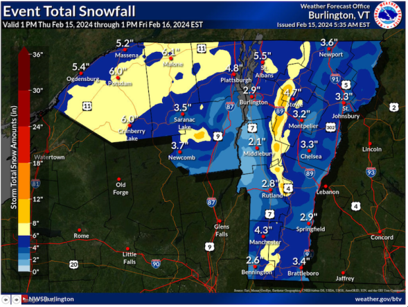
After a sunny start to the day, clouds will be on the increase out ahead of our next storm system. A clipper-type low tracking through the Great Lakes today will pass over the North Country overnight tonight bringing widespread snow to the region. NWS estimates are calling for 2″-3″ in the Champlain Valley with 4″-8″ here in Huntington with up to 10″-12″ over the spine of the Greens. The snow is expected to be pretty fluffy in nature and make for difficult travel conditions tonight and Friday morning. Snow is expected to taper off Friday morning with some lingering mountain snow showers possible. Unsettled but seasonable conditions are expected through the upcoming weekend with chances for snow showers both Saturday and Sunday as a series of shortwave troughs traverse the region. High pressure is expected to build in to start next week bringing some sunshine and a warming trend midweek as highs approach 40 degrees by Wednesday.
3-Day Forecast:
We’ll see increasing clouds today with a high near 28 and northwest winds around 5 mph becoming light and variable. Tonight should be cloudy with snow. Lows will be around 20 with southeast winds 8-13 mph becoming westerly after midnight. Chance of precipitation is 90% with new snow accumulations of 3″-5″ possible.
Friday should be mostly cloudy with snow likely before 7:00AM, diminishing to snow showers. Highs will be near 28 with northwest winds 10-16 mph. Chance of precipitation is 60% with new snow accumulations of around 1″ possible. Friday night should be mostly cloudy with a 30% chance of snow showers. Lows will be around 18 with west winds 3-6 mph. New snow accumulations of less than 0.50″ are possible.
Saturday should be mostly cloudy with a 40% chance of snow showers. Highs will be near 27 with west winds 5-9 mph. New snow accumulations of around 1″ are possible. Saturday night should be mostly cloudy with a 30% chance of snow showers. Lows will be around 8 with northwest winds 3-8 mph.
Almanac:
Last year on this date in Huntington we had a high of 57 and a low 26. We had 5″ of snow at the stake.
Last year in North Hero we had a high of 52 and a low of 31. We had 1″ of snow at the stake.
Burlington averages for this date are a low of 14 and a high of 31.
The record low was -26 in 1943.
The record high was 57 in 2023 (see above…)
The Lake Champlain lake level in Burlington is 96.97′.
The water temperature is 36˚.
Last year’s lake level was at 96.27′.
The Mt. Mansfield snow stake depth is 52″.
The average depth for this date is 60″.
Mt. Washington Summit Conditions
Current Temperature: 0˚
Winds are out of the north at 61 gusting to 81 mph
24 hr Precipitation: 2.4″ snow, 0.4″ melted precipitation
Visibility: over 100 miles under bluebird skies
Sky Notes:
Sunrise: 6:52AM
Sunset: 5:20PM
Length of day: 10:28:11
Today will be 2:50 longer than yesterday.
The Moon is a waxing crescent, 6 days old with 36% illumination.
Moonrise: 9:40AM
No Moonset
About Today’s Photo:
Richmond village sits pretty during the warm weather days we had recently. It’s nice to see an aerial shot of the town when it’s not flooded!
DJI Mini 3 drone, ISO 100, f/1.7, 1/16000″ exposure
Wednesday, February 14, 2024

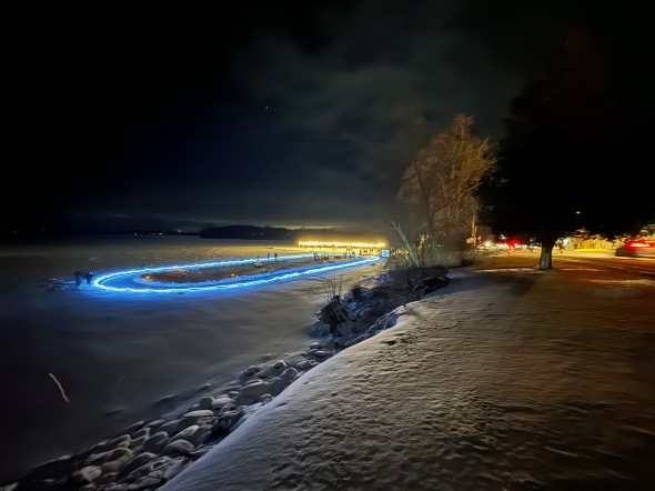
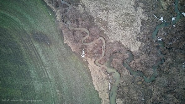 Aerial abstract with field and stream meander
Morning Observation:
This morning in Huntington at 7:05AM it’s currently 13 degrees and snowing lightly under cloudy skies. Winds are calm. Relative humidity is 84%, dewpoint 9, barometric pressure 29.93”. We picked up a surprise 4” of powder overnight and have 7” at the stake. Yesterday’s high was 35, and yesterday’s low was 26. The overnight low got down to 13.
This morning in North Hero it’s currently 16 degrees under cloudy skies. A few snowflakes are falling. Winds are out of the north at 3-5 mph. Relative humidity is 76%, dewpoint 9, barometric pressure 30.04”. We picked up 1” of new snow and have 1” at the stake. Yesterday’s high was 40, and yesterday’s low was 26. The overnight low got down to 15.
Forecast Discussion:
Well that’s was a surprise. To use the NWS lingo, the snow that we were expecting overnight “over-performed” and we picked up a nice 4″ of decent powder! Any lingering snow showers should taper off this morning giving way to a seasonably chilly day with blustery north winds and some breaks of sunshine this afternoon as high pressure builds in. Thursday will bring increasing clouds and our next chance of snow. Low pressure will track out of the Great Lakes and pretty much right through Vermont overnight Thursday bringing widespread accumulation snow into Friday morning. NWS estimates at this time are calling for 2″-3″ in the Champlain Valley, 3″-6″ of snow over the summits of Greens and ‘Dacks, and 1″-2″ in the NEK. We’ll see how this storm “performs”… Unsettled conditions are expected heading into the week with a series of weak shortwave troughs moving through the region bringing chances for light snow both Saturday and Sunday.
3-Day Forecast:
We’ll see cloudy skies and with snow showers this morning, giving way to partly sunny skies this afternoon. Highs will be near 25 with northwest winds 16-22 mph. Tonight should be partly cloudy with a low around 11 and northwest winds 10-17 mph.
Thursday should bring increasing clouds with a high near 29 and northwest winds 5-7 mph becoming southerly in the afternoon. Thursday night should be cloudy with snow likely. Lows will be around 22 with southeast winds around 7 mph becoming northwesterly after midnight. Chance of precipitation is 90% with new snow accumulation of 2″-4″ possible.
Friday should be mostly cloudy with snow likely before 8:00AM, diminishing to snow showers by 9:00AM. Highs will be near 29 with northwest winds 11-14 mph. Chance of precipitation is 70% with new snow accumulations of around 1″ possible. Friday night should be mostly cloudy with a low around 18 and northwest winds 5-10 mph becoming light and variable.
Saturday should be mostly cloudy with a 40% chance of snow showers. Highs will be near 27 with south winds 5-11 mph becoming westerly in the afternoon. Saturday night should be mostly cloudy with a 40% chance of snow showers before 8:00PM. Lows will be around 10 with northwest winds 8-13 mph becoming southwesterly after midnight.
Almanac:
Last year on this date in Huntington we had a high of 44 and a low of 26. We picked up 0.8″ of new snow and had 6″ at the stake.
Last year in North Hero we had a high of 49 and a low of 31. We had 1″ of snow at the stake.
Burlington averages for this date are a low of 14 and a high of 31.
The record low was -19 in 1987.
The record high was 55 in 1946.
The Lake Champlain lake level in Burlington is 97.04′.
The water temperature is 37˚.
Last year’s lake level was at 96.27′.
The Mt. Mansfield snow stake depth is 46″ (measured yesterday).
The average depth for this date is 58″.
Mt. Washington Summit Conditions
Current Temperature: -11˚
Winds are out of the north at 71 gusting to 85 mph
24 hr Precipitation: 3.2″ snow, 0.23″ melted precipitation
Visibility: less than 1/16 mile in blowing snow and freezing fog
Sky Notes:
Sunrise: 6:53AM
Sunset: 5:19PM
Length of day: 10:25:20
Today will be 2:49 longer than yesterday.
The Moon is a waxing crescent, 5 days old with 25% illumination.
Moonrise: 9:16AM
Moonset: 11:37PM
About Today’s Photo:
Meandering streams along the edge of a fallow farm field create an interesting aerial abstract.
DJI Mini 3 drone, ISO 100, f/1.7, 1/1600″ exposure
Tuesday, February 13, 2024

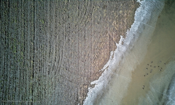 Aerial abstract with ducks
Morning Observation:
This morning in Huntington at 7:20AM it’s currently 30 degrees under cloudy skies. Winds are calm. Relative humidity s 80%, dewpoint 25, barometric pressure 29.69”. We have 3.5” of snow at the stake. Yesterday’s high was 35, and yesterday’s low was 30. The overnight low got down to 30.
This morning in North Hero it’s currently 26 degrees under cloudy skies. Winds are calm. Relative humidity is 96%, dewpoint 25, barometric pressure 29.78”. No snow. Yesterday’s high was 36, and yesterday’s low was 31. The overnight low got down to 26.
Forecast Discussion:
Morning radar imagery shows a deep low pressure system just off the coast of Richmond, Virginia at this hour. The low is expected to track eastward through the day today with only a glancing blow of precipitation falling over far southern Vermont. The rest of us will see dry and seasonably mild conditions today with highs in the mid to upper 30s. Weak shortwave energy will drop into the region overnight tonight bringing the chance of some light snow showers, and we might pick up an inch or so of fluff. Dry, blustery, and seasonably chilly conditions are expected for Wednesday as high pressure builds in briefly. Low pressure tracking out of the Great Lakes on Thursday will bring the chance of some accumulating snow Thursday night into Friday. The NWS is calling for as much as 3″-6″ of fluffy, light snow by Friday morning. Fingers crossed, but I’ll believe it when I’m shoveling it! Unsettled conditions are expected heading into the weekend with seasonably cool temperatures and scattered snow showers expected Saturday. Sunday’s looking dry and partly sunny.
3-Day Forecast:
We’ll see mostly cloudy skies today with a high near 38 and north winds 5-10 mph. Tonight should be mostly cloudy with a 50% chance of snow showers late. Lows will be around 17 with northwest winds 8-13 mph after midnight. New snow accumulations of around 1″ are possible.
Wednesday should be partly sunny with a 30% chance of snow showers. Highs will be near 24 with northwest winds 14-18 mph. New snow accumulations of less than 0.50″ are possible. Wednesday night should be partly cloudy with a low around 15 and northwest winds 10-17 mph.
Thursday should bring increasing clouds with a 30% chance of snow after 5:00PM. Highs will be near 29 with northwest winds 5-7 mph becoming southerly in the afternoon. Little or no snow accumulation is expected. Thursday night should be cloudy with snow. Lows will be around 22 with southeast winds 5-11 mph becoming westerly after midnight. Chance of precipitation is 90% with 2″-4″ of new snow possible.
Almanac:
Last year on this date in Huntington we had a high of 47 and a low of 21. We had 5″ of snow at the stake.
Last year in North Hero we had a high of 41 and a low of 21. We had 2″ of snow at the stake.
Burlington averages for this date are a low of 14 and a high of 31.
The record low was -25 in 1967.
The record high was 53 in 1984.
The Lake Champlain lake level in Burlington is 97.09′.
The water temperature is 37˚.
Last year’s lake level was at 96.27′.
The Mt. Mansfield snow stake depth is 46″.
The average depth for this date is 57″.
Mt. Washington Summit Conditions
Current Temperature: 8˚
Winds are out of the west at 8-12 mph
24 hr Precipitation: 0.2″ snow, 0.02″ melted precipitation
Visibility: less than 1/16 mile in freezing fog
Sky Notes:
Sunrise: 6:55AM
Sunset: 5:17PM
Length of day: 10:22:31
Today will be 2:48 longer than yesterday.
The Moon is a waxing crescent, 4 days old with 16% illumination.
Moonrise: 8:54AM
Moonset: 10:19PM
About Today’s Photo:
Fallow corn fields along the River Road between Richmond and Essex Jct offer an opportunity to explore composition and texture from above. A wet swale provided a nice pool for a group of ducks to cavort in.
DJI Mini 3 drone, ISO 100, f/1.7, 1/1600″ exposure
Monday, February 12, 2024
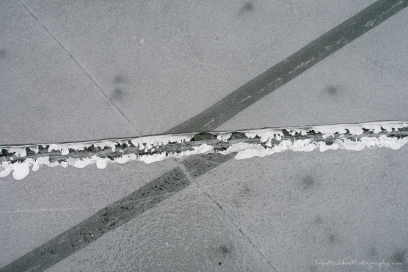 A history of cracks in sheet ice
Morning Observation:
This morning in Huntington at 7:35AM it’s currently 32 degrees under cloudy skies. Winds are calm. Relative humidity is 89%, dewpoint 29, barometric pressure 29.92”. We have 3.5” of snow at the stake. Yesterday’s high was 42, and yesterday’s low was 33.
This morning in North Hero it’s currently 34 degrees under cloudy skies. Winds are calm. Relative humidity is 82%, dewpoint 29, barometric pressure 29.95”. No snow. Yesterday’s high was 41, and yesterday’s low was 35. The overnight low got down to 33.
Forecast Discussion:
Dry and seasonably mild conditions will be with us again today as highs top out in the mid 30s and morning clouds give way to some glimpses of sun this afternoon. Current forecast models show the coastal storm I’ve been talking about over the past couple of days tracking south and east of the Cape Cod benchmark on Tuesday. This means there will be even less snow in Vermont with current estimates of 1″-3″ of snow over southern Vermont instead of the 3″-6″ previously forecast. Nuthin’ up here in Huntington from this system. However, a weak shortwave is expected to swing through Tuesday night bringing some light snow. Dry and seasonable conditions are expected through the middle of the week. The next chance of precipitation arrives overnight Thursday as low pressure swings out of the Great Lakes and through the North Country. There’s not a whole lot of moisture to work with in this system so snowfall is expected to be minimal. Seasonable conditions are expected heading into the weekend with the chance of some light snow showers Saturday and Sunday.
3-Day Forecast:
We’ll see mostly cloudy skies today with a high near 36 and west winds 5-7 mph in the morning. Tonight should be mostly cloudy with a low around 26 and northeast winds around 5 mph.
Tuesday should be cloudy with a slight chance of light snow. Highs will be near 33 with north winds 7-15 mph. Tuesday night should be mostly cloudy with a 40% chance of snow showers. Lows will be around 18 with northwest winds 8-10 mph. New snow accumulations of less than 1″ are possible.
Wednesday should be partly sunny with a high near 24 and northwest winds 14-17 mph. Wednesday night should be partly cloudy with a low around 15 and northwest winds 11-18 mph.
Almanac:
Last year on this date in Huntington we had a high of 43 and a low of 20. We had 5″ of snow at the stake.
Last year in North Hero we had a high of 38 and a low of 26. We had 2″ of snow at the stake.
Burlington averages for this date are a low of 13 and a high of 31.
The record low was -30 in 1979.
The record high was 56 in 1999.
The Lake Champlain lake level in Burlington is 97.10′.
The water temperature is 37˚.
Last year’s lake level was at 96.20′.
The Mt. Mansfield snow stake depth is 46″.
The average depth for this date is 57″.
Mt. Washington Summit Conditions
Current Temperature: 16˚
Winds are out of the NW at 40 mph
24 hr Precipitation: 0
Visibility: over 100 miles under clear skies
Sky Notes:
Sunrise: 6:56AM
Sunset: 5:16PM
Length of day: 10:19:42
Today will be 2:47 longer than yesterday.
The Moon is a waxing crescent, 2.7 days old with 8% illumination.
Moonrise: 8:33AM
Moonset: 9:00PM
About Today’s Photo:
Sheet ice offers an ever-changing canvas of shapes and forms. The ice is a living thing, flexing under the force of wind and sun to crack, pull apart, draw back together, melt and refreeze. This shot offers a glimpse of this cryogenic geology where several cracks have formed, shifted, and refrozen. If you look carefully, you can see tiny frost feather along the broad horizontal crack indicative of moisture leaching up from below.
Sony A7II, Sony 24-240mm lens @ 35mm, ISO 800, f/16, 1/50″ exposure
Sunday, February 11, 2024
 A pressure ridge off our neighbor’s point
Morning Observation:
This morning in Huntington at 7:30AM it’s currently 35 degrees under cloudy skies. Winds are calm. Relative humidity is 84%, dewpoint 31, barometric pressure 29.86”. We have 3.5” of snow at the stake. Yesterday’s high was 56, and yesterday’s low was 35. The overnight low got down to 35.
This morning in North Hero it’s currently 38 degrees under cloudy skies. Winds are calm. Relative humidity is 78%, dewpoint 31, barometric pressure 29.88”. No snow. We picked up 0.14” of rain in the past 24hrs. Yesterday’s high was 45, and yesterday’s low was 38. The overnight low got down to 37.
Forecast Discussion:
Mostly dry and mild conditions are expected today and Monday as a weak ridge of high pressure moves over the region. Low pressure tracking out the Ohio River valley Monday night will track through New England on Tuesday and just inside the Cape Cod benchmark. This will bring a period of accumulating snow to southern Vermont during the day on Tuesday. The forecast calls for 2″-6″ over far southern Vermont with little or no snow making it as far north as Huntington. Dry and seasonably chilly conditions will arrive for midweek before a quick clipper-type low moves through Thursday night into Friday bringing the chance of some light snow.
3-Day Forecast:
We’ll see cloudy skies today with a high near 40 and northwest winds 7-9 mph. Tonight should be cloudy with a low around 26 and northwest winds around 6 mph becoming calm after midnight.
Monday should be mostly cloudy with a high near 38 and west winds 5-9 mph. Monday night should be mostly cloudy with a low around 25 and west winds 5-8 mph becoming light and variable.
Tuesday should start out cloudy with a 40% chance of morning snow. Skies should gradually becoming mostly sunny with a high near 30 and north winds 5-11 mph. New snow accumulations of less than 0.50″ are possible. Tuesday night should be mostly cloudy with a low around 15 and northwest winds around 14 mph.
Almanac:
Last year on this date in Huntington we had a high of 35 and a low of 25. We picked up 0.5″ of new snow and had 5″ at the stake.
Last year in North Hero we had a high of 35 and a low of 22. We picked up 0.75″ of new snow and had 2″ at the stake.
Burlington averages for this date are a low of 13 and a high of 30.
The record low was -27 in 1979.
The record high was 40 in 2009. (Burlington set a new record high of 56 yesterday.)
The Lake Champlain lake level in Burlington is 97.07′.
The water temperature is 38˚.
Last year’s lake level was at 96.19′.
The Mt. Mansfield snow stake depth is 47″.
The average depth for this date is 57″.
Mt. Washington Summit Conditions
Current Temperature: 15˚
Winds are out of the NW at 47 gusting to 56 mph
24 hr Precipitation: 0.6″ snow, 0.07″ melted precipitation
Visibility: less than 1/16 mile in freezing fog
Sky Notes:
Sunrise: 6:58AM
Sunset: 5:14PM
Length of day: 10:16:54
Today will be 2:46 longer than yesterday.
The Moon is a waxing crescent, 1.6 days old with 3% illumination.
Moonrise: 8:11AM
Moonset: 7:39PM
About Today’s Photo:
Pressure ridges in ice form when plates of ice crack and then push against each other to form ridges. Often these ridges will produce uplifted plates that can form very fanciful sculptures. Skaters approach pressure ridges with caution as there is often open water in the cracks between the plates. The photo below shows a closer look at a large flower-like ridge which you can see near the top of the ridge in the first photo.
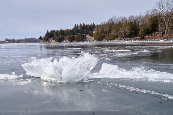
Saturday, February 10, 2024

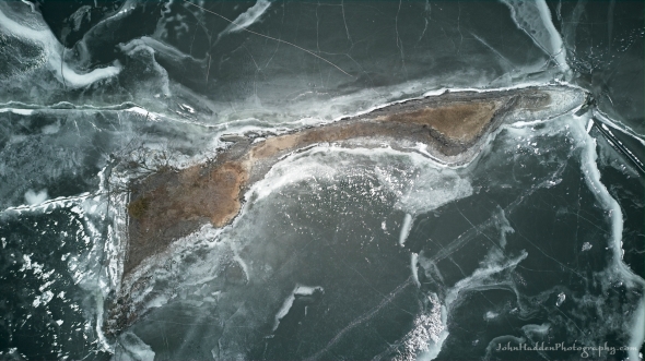 An aerial view of Hen Island off North Hero
Morning Observation:
This morning in Huntington at 7:45AM it’s currently 39 degrees under mostly cloudy skies. Winds are calm. Relative humidity is 94%, dewpoint 36, barometric pressure 29.76”. We have 4” of snow at the stake. Yesterday’s high was 53, and yesterday’s low was 31. The overnight low got down to 36.
This morning in North Hero it’s currently 41 degrees under mostly cloudy skies. Winds are out of the south at 15-18 mph. Relative humidity is 83%, dewpoint 36 barometric pressure 29.75”. No snow. Yesterday’s high was 46, and yesterday’s low was 37. The overnight low got down to 41.
Forecast Discussion:
A warm front is currently lifting through the region and will bring another day of warm, potentially record breaking temperatures with highs topping out in the low to mid 50s. Scattered light rain showers are expected over much of the region later this afternoon out ahead of a weak cold front that will swing through this evening. We might even hear a rumble of thunder or two tonight. Behind the front we should see some more showers and mountain snow showers. Temperatures tonight should drop to near freezing. Drier air is expected to move in for Sunday bringing some glimpses of sun along with highs in the mid 30s to low 40s. High pressure will build in for Monday bringing dry and continued mild conditions with highs in the mid 30s to low 40s. Low pressure will track from the Ohio River valley eastward and off the Delmarva Monday night, and then swing up somewhere pretty close to the Cape Cod benchmark and out to sea Tuesday night. Light snow shold spread northward into our region early Tuesday morning and exit by the evening. The best chance for accumulating snow will likely be in Rutland and Windsor counties with only a couple of inches of snow are anticipated there. Snowfall amounts should drop off significantly as you head north so we’re not likely to see any here in Huntington.
3-Day Forecast:
We’ll see mostly cloudy skies today with scattered showers, mainly after 10:00AM. Highs will be near 52 with south winds 9-11 mph. Chance of precipitation is 50% with rainfall amounts of less than 0.10″ possible. Tonight should be mostly cloudy with a slight chance of rain showers before 2:00AM, with a slight chance of snow showers after 4:00AM. Lows will be around 34 with west winds 6-8 mph.
Sunday should be mostly cloudy with a high near 40 and west winds around 9 mph. Sunday night should be mostly cloudy with a low around 28 and west winds 5-7 mph.
Monday should be partly sunny with a high near 40 and west winds 6-13 mph. Monday night should be partly cloudy with a low around 24 and north winds around 6 mph.
Almanac:
Last year on this date in Huntington we had a high of 50 and a low of 33. We picked up 0.02″ of rain and had 5.5″ of snow at the stake.
Last year in North Hero we had a high of 46 and a low of 33. We picked up 0.05″ of rain and had 2″ of snow at the stake.
Burlington averages for this date are a low of 13 and a high of 30.
The record low was -26 in 1948.
The record high was 46 in 2001. (Burlington set a new record high yesterday of 53˚.)
The Lake Champlain lake level in Burlington is 97.08′.
The water temperature is 37˚.
Last year’s lake level was at 96.14′.
The Mt. Mansfield snow stake depth is 47″.
The average depth for this date is 57″.
Mt. Washington Summit Conditions
Current Temperature: 30˚
Winds are out of the west at 46-51 mph
24 hr Precipitation: 0
Visibility: less than 1/16 mile in freezing fog
Sky Notes:
Sunrise: 6:59AM
Sunset: 5:13PM
Length of day: 10:14:08
Today will be 2:44 longer than yesterday.
The Moon is a waxing crescent, 0.4″ old with 0.2% illumination.
Moonrise: 7:46AM
Moonset: 6:16PM
About Today’s Photo:
Hen island is a tiny stony island just north of our camp on North Hero. The island is owned by the Nature Conservancy and is valued as a tern nesting cite in the summer months. I find the patterns of ice with its cracks and fissures to be fascinating.
DJI Mini 3 drone, ISO 100, f/1.7, 1/1600″ exposure
Friday, February 9, 2024

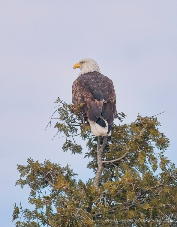 A bald eagle along Pelots Point Road
Morning Observation:
This morning in Huntington at 7:55AM it’s currently a balmy 45 degrees under cloudy skies. Winds are out of the south at 5-8 mph. Relative humidity is 55%, dewpoint 30. Barometric pressure 30.03”. We have 4.75” of snow at the stake. Yesterday’s high was 48, and yesterday’s low was 22. The overnight low got down to 31.
This morning in North Hero it’s currently 41 degrees under cloudy skies. Winds are out of the south at 16-20 gusting to 26 mph. Relative humidity is 67%, dewpoint 31, barometric pressure 30.02”. No snow. Yesterday’s high was 42, and yesterday’s low was 28.
Forecast Discussion:
Our stretch of unseasonably warm temperatures will continue into the weekend as low pressure well to our west lifts a warm front through the region today. We’ll see highs in the upper 40s to low 50s today and mid to upper 50s tomorrow—record breaking territory. After a cloudy start to the day, we should be seeing some breaks of sun as a dry slot moves in overhead. The aforementioned low will lob off bits of moisture which will drift eastward bringing occasional rain showers and sprinkles overnight tonight, through Saturday and into Saturday night. There’s not a lot of moisture to work with in the diffuse system so rain impacts will be minimal, however gusty south winds and warmth will impact our snowpack such as it is. Dry and somewhat cooler conditions are expected to moving in for Sunday with highs around 40. A quick moving low pressure system is expected to track to our south later Monday night through Tuesday bringing an outside chance of some snow to far southern Vermont, otherwise, dry conditions are expected heading into next week with a return to more seasonable temperatures.
3-Day Forecast:
We’ll see cloudy skies through mid-morning, then gradual clearing, with a high near 50 and south winds 10-15 mph gusting to 24 mph. Tonight should be partly cloudy with a slight chance of showers. Lows will be around 38 with south winds 10-15 mph.
Saturday should be cloudy with showers likely, mainly after 4:00PM. Highs will be near 54 with south winds 8-15 mph. Chance of precipitation is 60% with rainfall amounts of less than 0.10″ possible. Saturday night should be cloudy with showers likely, mainly before 7:00PM. Lows will be around 34 with southwest winds around 7 mph becoming northwesterly after midnight. Chance of precipitation is 60% with rainfall amounts of less than 0.10″ possible.
Sunday should be mostly cloudy with a high near 40 and west winds around 8 mph. Sunday night should be mostly cloudy with a low around 29 and northwest winds 3-7 mph.
Almanac:
Last year on this date in Huntington we had a high of 49 and a low of 19. We picked up 0.36″ of rain and had 7.5″ of snow at the stake.
Last year in North Hero we had a high of 41 and a low of 26. We picked up 0.48″ of rain and had 3″ of snow at the stake.
Burlington averages for this date are a low of 13 and a high of 30.
The record low was -20 in 1963.
The record high was 48 in 1990 (likely to fall today…)
The Lake Champlain lake level in Burlington is 97.12′.
The water temperature is 36˚.
Last year’s lake level was at 96.12′.
The Mt. Mansfield snow stake depth is 47″.
The average depth for this date is 56″.
Mt. Washington Summit Conditions
Current Temperature: 29˚
Winds are out of the SW at 32-36 mph
24 hr Precipitation: 0
Visibility: around 90 miles under overcast skies.
Sky Notes:
Sunrise: 7:00AM
Sunset: 5:12PM
Length of day: 10:11:23
Today will be 2:43 longer than yesterday.
The Moon is new, 28.8 days old with 0% illumination.
Moonrise: 7:16AM
Moonset: 4:52PM
About Today’s Photo:
Ice wasn’t the only thing we saw up on North Hero the other day. Robin spied this bald eagle calmly sitting in a cedar above the cliffs along Pelots Point Road. It was nice enough to stick around while I got a nice portrait.
Sony A7II, Sigma 100-400mm lens @ 400mm, ISO 800, f/7.1, 1/1000″ exposure
Thursday, February 8, 2024

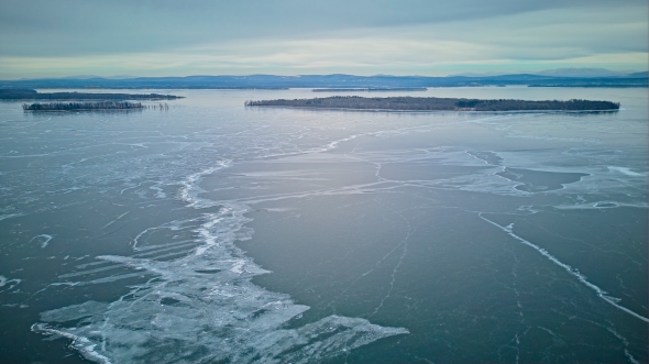 Looking northeast towards Knight and Dameas Islands
Morning Observation:
This morning in Huntington at 7:10AM it’s currently 23 degrees under partly cloudy skies. Winds are calm. Relative humidity is 92%, dewpoint 21, barometric pressure 30.34”. We have 5” of snow at the stake. Yesterday’s high was 37, and yesterday’s low was 13. The overnight low got down to 23.
This morning in North Hero it’s currently 29 degrees under partly cloudy skies. Winds are out of the south at 3-5 mph. Relative humidity is 92%, dewpoint 27, barometric pressure 30.37”. Yesterday’s high was 32, and yesterday’s low was 18. The overnight low got down to 28.
Forecast Discussion:
Unseasonably warm weather will be the rule from today clear through the weekend as high pressure and a developing southerly airflow bump highs into the mid 40s today, upper 40s on Friday, and low 50s on Saturday. Disorganized low pressure passing well to our west Saturday will bring periods of light rain showers Saturday afternoon into Saturday night, but precipitation amounts are expected to be light. Cooler air will begin to filter back in on Sunday with highs expected to be in the mid to upper 30s. A southern stream low pressure system is expected to track through southern New England Monday night into Tuesday bringing the chance of some snow showers to the region as temperatures finally become more seasonable by Tuesday.
3-Day Forecast:
We’ll see mostly sunny skies today with a high near 44 and southwest winds around 5 mph. Tonight should be mostly cloudy with a slight chance of sprinkles. Lows will be around 35 with south winds 6-10 mph increasing to 15-20 over Lake Champlain after midnight.
Friday should be mostly sunny and mild with a high near 49 with south winds 10-14 mph in Huntington and 16-20 over Lake Champlain. Friday night should be mostly cloudy and very mild with a low around 39 and south winds 9-15 mph.
Saturday should be mostly cloudy with a 50% chance of afternoon rain showers. Highs will be near 51 with south winds 6-13 mph. Rainfall amounts of less than 0.10″ are possible. Saturday night should be cloudy with a 50% chance of rain showers. Lows will be around 35 with southwest winds 6-9 mph becoming westerly after midnight. Rainfall amounts between 0.10″-0.25″ are possible.
Almanac:
Last year on this date in Huntington we had a high of 42 and a low of 24. We picked up 0.09″ of rain and 0.40″ of new snow and had 7.5″ at the stake.
Last year in North Hero we had a high of 44 and a low of 29. We had 5″ of snow at the stake.
Burlington averages for this date are a low of 13 and a high of 30.
The record low was -20 in 1967.
The record high was 48 in 1965.
The Lake Champlain lake level in Burlington is 97.23′.
The water temperature is 37˚.
Last year’s lake level was at 96.18′.
The Mt. Mansfield snow stake depth is 47″.
The average depth for this date is 55″.
Mt. Washington Summit Conditions
Current Temperature: 22˚
Winds are out of the north at 16 gusting to 20 mph
24 hr Precipitation: 0
Visibility: less than 1/16″ mile in freezing fog
Sky Notes:
Sunrise: 7:02AM
Sunset: 5:10PM
Length of day: 10:08:40
Today will be 2:42 longer than yesterday.
The Moon is a waning crescent, 27.6 days old with 4% illumination.
Moonrise: 6:38AM
Moonset: 3:25PM
About Today’s Photo:
We went and visited our camp yesterday and had a magical walk out on the ice. It was some of the best skating ice that I’ve ever seen with 4″-6″ of smooth ice extending for miles in all directions. We met with a group of 4 “nordic skaters” who had been out all day and covered 60 miles and had another 20 to go. Makes me want to get into that sport!
Today’s photo looks northeastward over Knight and Dameas Islands with Woods and Burton Island beyond. Mt. Mansfield is on the horizon to the right.
DJI Mini 3 drone, ISO 100, f/1.7, 1/1600″ exposure
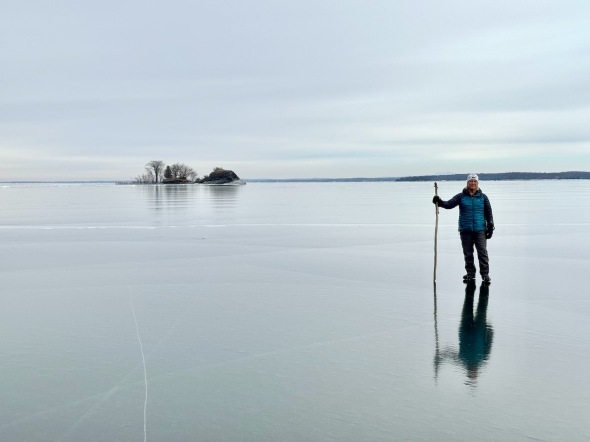 Bonus Pic: Robin on the ice with Hen Island in the background
Wednesday, February 7, 2024

 Orion above the trees
Morning Observation:
This morning in Huntington at 7:05AM it’s currently 13 degrees under clear skies. Winds are calm. Relative humidity is 92%, dewpoint 11, barometric pressure 30.36”. We have 5” of snow at the stake. Yesterday’s high was 34, and yesterday’s low was 10. The overnight low got down to 13.
This morning in North Hero it’s currently 18 degrees under clear skies. Winds are calm. Relative humidity is 97%, dewpoint 17, barometric pressure 30.43”. No snow. Yesterday’s high was 35, and yesterday’s low was 19.
Forecast Discussion:
High pressure will continue to deliver dry and increasingly warm conditions heading into the weekend. Clouds will be on the increase during the day today as highs reach into the mid to upper 30s. A southerly airflow is expected to set up on Thursday as a warm front lifts through the region bringing more clouds and increasing warmth. We’ll see highs pushing into the mid 40s both Thursday and Friday, and into the upper 40s to low 50s by Saturday. Low pressure passing well to our west will bring the chance of precipitation overnight Friday into Saturday. The disorganized and fragmented nature of the low should mean we only see some widely scattered showers or sprinkles Saturday, so not a washout by any means. Cooler temperatures will begin to filter in by Sunday with highs around 40, with some lingering snow showers possible Sunday night as temperatures drop below freezing. Mild conditions will continue into next week with temperatures expected to return to more seasonable levels by midweek.
3-Day Forecast:
We’ll see increasing clouds today with a high near 35 and calm winds. Tonight should be mostly cloudy with a low around 22 and calm winds.
Thursday should start out mostly cloudy then gradually becoming sunny, with a high near 44 and south winds around 5 mph. Thursday night should be mostly cloudy with a low around 33 and south winds 6-12 mph.
Friday should be partly sunny with a high near 46 and south winds 10-15 mph. Friday night should be mostly cloudy with a 30% chance of showers. Lows will be around 38 with south winds 11-16 mph.
Almanac:
Last year on this date in Huntington we had a high of 44 and a low of 3. We had 7.5″ of snow at the stake.
Last year in North Hero we had a high of 37 and a low of 11. We had 5″ of snow at the stake.
Burlington averages for this date are a low of 13 and a high of 30 (both up 1˚).
The record low was -27 in 1993.
The record high was 49 in 2005 (we had a high of 45 in Huntington).
The Lake Champlain lake level in Burlington is 97.32′.
The water temperature is 37˚.
Last year’s lake level was at 96.29′.
The Mt. Mansfield snow stake depth is 48″.
The average depth for this date is 55″.
Mt. Washington Summit Conditions
Current Temperature: 21˚
Winds are out of the NE at 13 mph
24 hr Precipitation: 0
Visibility: around 80 miles under clear skies.
Sky Notes:
Sunrise: 7:03AM
Sunset: 5:09PM
Length of day: 10:05:58
Today will be 2:40 longer than yesterday.
The Moon is a waning crescent, 26.5 days old with 9% illumination.
Moonrise: 5:50AM
Moonset: 2:04PM
About Today’s Photo:
I read an article about the iPhone 15 Pro’s “Night Mode”, and thought I’d give it a spin. Color me impressed. This shot to the south last evening shows the constellation Orion with its 3-star belt and dangling sword clearly visible. What’s even more impressive is that the camera managed to tease out the light from M42—the great Orion Nebula—which encompasses the middle star of the sword. It shows as a slightly blurry spot. Not bad for something I can carry in my shirt pocket…
Tuesday, February 6, 2024

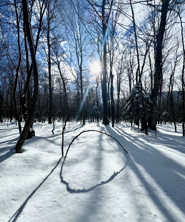 Dramatic shadows in a snowy woods
Morning Observation:
This morning in Huntington at 7:30AM it’s currently 10 degrees under clear skies. Winds are calm. Relative humidity is 92%, dewpoint 8, barometric pressure 30.28”. We have 5” of snow at the stake. Yesterday’s high was 31, and yesterday’s low was 10. The overnight low got down to 10.
This morning in North Hero it’s currently 24 degrees under clear skies. Winds are calm. Relative humidity is 76%, dewpoint 17, barometric pressure 30.37”. No snow. Yesterday’s high was 33, and yesterday’s low was 18. The overnight low got down to 19.
Forecast Discussion:
High pressure continues to control our weather bringing dry and mostly sunny conditions today with highs in the low to mid 30s. A series of weak warm fronts will begin to lift into the region starting Wednesday bringing in some clouds and increasingly warm temperatures with highs Wednesday in the mid to upper 30s, low 40s on Thursday & Friday, and upper 40s on Saturday. Low pressure will track to our west out of the Great Lakes later Friday bringing our next round of precipitation. We’ll likely see light rain starting Friday night into Saturday, but there’s not a whole lot of moisture associated with this rather disorganized system so it shouldn’t be a washout. Temperatures are expected to drop to around 40 on Sunday and low to mid 30s on Monday with a slight chance of rain or snow shower possible.
3-Day Forecast:
We’ll see sunny skies today with a high near 34 and north winds 5-7 mph. Tonight should start out clear, then become mostly cloudy, with a low around 14 and calm winds.
Wednesday should be partly sunny with a high near 36 and light and variable winds. Wednesday night should be mostly cloudy with a low around 24 and calm winds.
Thursday should be partly sunny with a high near 42 and calm winds becoming southerly around 6 mph in the afternoon. Thursday night should be mostly cloudy with a low around 31 and south winds 5-10 mph.
Friday should be mostly cloudy with a high near 44 and south winds 7-10 mph. Friday night should be mostly cloudy with a 40% chance of showers. Lows will be around 37 with south winds 9-18 mph.
Almanac:
Last year on this date in Huntington we had a high of 35 and a low of 7. We had 7.5″ of snow at the stake.
Last year in North Hero we had a high of 36 and a low of 15. We had 5″ of snow at the stake.
Burlington averages for this date are a low of 12 and a high of 29.
The record low was -24 in 1993.
The record high was 50 in 2012 (we had a high of 47 in Huntington).
The Lake Champlain lake level in Burlington is 97.41′.
The water temperature is 37˚.
Last year’s lake level was at 96.30′.
The Mt. Mansfield snow stake depth is 48″.
The average depth for this date is 54″.
Mt. Washington Summit Conditions
Current Temperature: 13˚
Winds are out of the NE at 32-34 mph
24 hr Precipitation: 0
Visibility: around 80 miles under clear skies.
Sky Notes:
Sunrise: 7:04AM
Sunset: 5:07PM
Length of day: 10:03:17
today will be 2:38 longer than yesterday.
The Moon is a waning crescent, 25.5 days old with 17% illumination.
Moonrise: 4:50AM
Moonset: 12:54PM
About Today’s Photo:
Sunshine and snow make for some dramatic shadows in the snowy woods at Seyon Lodge in Groton, Vermont.
iPhone 15 Pro
Monday, February 5, 2024

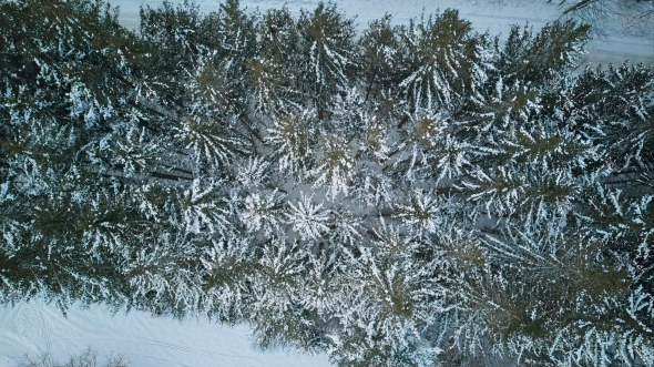 Snow-laden spruce trees from above
Morning Observation:
This morning in Huntington at 7:50AM it’s currently 10 degrees under clear skies. Winds are calm. Relative humidity is 91%, dewpoint 8, barometric pressure 30.07”. We have 5” of snow at the stake. Yesterday’s high was 33, and yesterday’s low was 10. The overnight low got down to 10.
This morning in North Hero it’s currently 25 under clear skies. Winds are calm. Relative humidity is 78%, dewpoint 19, ,barometric pressure 30.17”. No snow. Yesterday’s high was 32, and yesterday’s low was 18. The overnight low got down to 18.
Forecast Discussion:
High pressure over much of the northeast will continue to deliver a stretch of dry and sunny weather through much of this week. We’ll see some clouds overnight tonight as a weak trough skirts through. Temperature will be seasonable for the first half of the week with a warming trend expected midweek and into the weekend as highs top out in the low 40s Thursday and mid 40s Friday through Sunday. Our next chance of precipitation arrives later Friday night as low pressure tracks to our north. There are some hints in the forecast models that we might see a bit of wet snow at the outset of the this system, but with daytime highs approaching record levels over the weekend, rain will be the likely precipitation type for most locations. A second low pressure system is expected to skirt to our south later on Sunday as cooler air moves back into the region bringing a chance of some light snow to wrap things up. Stay tuned…
3-Day Forecast:
We’ll see sunny skies today with a high near 30 and north winds 6-9 mph. Tonight should be partly cloudy with a low around 11 and north winds 3-8 mph.
Tuesday should be mostly sunny with a high near 31 and north winds 3-6 mph. Tuesday night should be partly cloudy with a low around 13 and light north winds.
Wednesday should be mostly sunny with a high near 36 and light northwest winds. Wednesday night should be mostly cloudy with a low around 16 and calm winds.
Almanac:
Last year on this date in Huntington we had a high of 40 and a low of 13. We had 8″ of snow at the stake.
Last year in North Hero we had a high of 38 and a low of 12. We had 6″ of snow at the stake.
Burlington averages for this date are a low of 12 and a high of 29.
The record low was -17 in 1978.
The record high was 53 in 2019 (we had a high of 53 in Huntington).
The Lake Champlain lake level in Burlington is 97.45′.
The water temperature is 37˚.
Last year’s lake level was at 96.27′.
The Mt. Mansfield snow stake depth is 48″.
The average depth for this date is 54″.
Mt. Washington Summit Conditions
Current Temperature: 4˚
Winds are out of the NE at 30 gusting to 49 mph
24 hr Precipitation: 0
Visibility: over 100 miles under clear skies.
Sky Notes:
Sunrise: 7:05AM
Sunset: 5:06PM
Length of day: 10:00:38
Today will be 2:37 longer than yesterday.
The Moon is a waning crescent, 24.5 days old with 26% illumination.
Moonrise: 3:38AM
Moonset: 11:56AM
About Today’s Photo:
I’ve been thinking about a shot like this for most of the winter, but the opportunity hasn’t presented itself (because, like, not too much snow here…) until we were at Seyon Lodge. At the southern end of the Northeast Kingdom, the Groton area begins to show the characteristics of the northern boreal forests with spruce becoming the dominant conifer species. The bank of spruce right near the Lodge finally offered an opportunity to create the shot!
DJI Mini 3 drone, ISO 100, f/1.7, 1/1600″ exposure
