Thursday, July 31, 2014

A popular thistle in our ornamental garden
Morning Observation:
This morning in Huntington at 8:30AM it’s currently 64 degrees under mostly cloudy skies. Winds are calm. Relative humidity is 91%, dewpoint 61, barometric pressure 30.02″. Yesterday’s high was 75, and the overnight low was 53.
Forecast:
A potent upper level disturbance will mover into the region today. We’ll see mostly cloudy skies with numerous showers and thunderstorms this afternoon. Some thunderstorms may produce gusty winds and small hail this afternoon. Highs will be in the lower 70s with south winds around 10 mph. Chance of rain is 70%. Tonight should be partly cloudy with isolated showers until midnight. Lows will be in the mid 50s with light and variable winds. Chance of rain is 20%.
Friday should be partly sunny with a slight chance of convection-based showers and thunderstorms in the afternoon. Highs will be in the upper 70s with south winds around 10 mph. Chance of rain is 20%. Friday night should be partly cloudy with lows around 60 and south winds around 10 mph.
Saturday’s looking mostly cloudy with a chance of afternoon convective showers and thunderstorms. Highs will be in the mid 70s with light and variable winds. Chance of rain is 50%. Saturday night should be mostly cloudy with lows in the upper 50s.
Almanac:
Last year on this date we had a high of 79 and a low of 52.
Burlington norms for this date are highs of 81 and lows of 60
The record high was 96°F in 1999 (we had a high of 92).
The record low was 42°F in 1964.
Sky Notes:
Sunrise: 5:38 AM EDT
Sunset: 8:18 PM EDT
Length of Visible Light: 15h 47m
Length of Day: 14h 40m
The Moon is a waxing crescent (quite lovely yesterday evening!) 4d 13h old with 18% illumination.
Moonrise: 10:15 AM EDT
Moonset: 10:16 PM EDT
About Today’s Photo:
The ornamental thistles in our flower garden are quite popular with the local pollinators right now. Each of the dozens of flower head hosts a busy collection of bees and other insects.
Nikon D600, Sigma 105mm lens, ISO 1250, f/13, 1/60″ exposure.
Wednesday, July 30, 2014

A freshly minted grasshopper in the front field
Morning Observation:
This morning in Huntington at 7:00AM it’s currently 49 degrees under mostly cloudy skies. Winds are calm. Relative humidity is 99%, dewpoint 49, barometric pressure 30.00″ and rising. Yesterday’s high was 70, and the overnight low was 46.
Forecast:
A low pressure system parked over northern Ontario will pivot cool air along with a series of upper level disturbance through our region for the next several days. We’ll see partly sunny skies today with a slight chance of showers and thunderstorms this afternoon. Highs will be in the lower 70s with light and variable winds. Chance of rain is 20%. Tonight should be partly cloudy with a slight chance of showers until midnight. Lows will be in the mid 50s with light and variable winds. Chance of rain is 20%.
A more powerful disturbance will roll through Thursday bringing shows and thunderstorms mainly in the afternoon. Highs will be in the lower 70s with south winds around 10 mph. Chance of rain is 70%. Thursday night should be partly cloudy with a chance of showers and thunderstorms. Lows will be in the mid 50s with south winds around 10 mph. Chance of rain is 50%.
Friday’s looking partly sunny with a chance of showers. Highs will be in the upper 70s with south winds around 10 mph. Chance of rain is 30%. Friday night should be partly cloudy with lows in the lower 60s.
Almanac:
Last year on this date we had a high of 74 and a low of 52. We picked up 0.02″ of rain.
Burlington norms for this date are highs of 81 and lows of 60.
The record high was 96°F in 1959.
The record low was 45°F in 1952.
Sky Notes:
Sunrise: 5:37 AM EDT
Sunset: 8:20 PM EDT
Length of Visible Light: 15h 49m
Length of Day: 14h 42m
The Moon is a waxing crescent, 3d 12h old with 11% illumination.
Moonrise: 9:16 AM EDT
Moonset: 9:49 PM EDT
About Today’s Photo:
This young grasshopper was trying to hide from me in the grasses of our front field. He was only about an inch long, so had probably recently emerged.
Nikon D600, Sigma 105mm lens, ISO 1250, f/16, 1/400″ exposure.
Tuesday, July 29, 2014

Another small jumping spider out in the front field.
Morning Observation:
This morning in Huntington at 6:20AM it’s currently 54 degrees under mostly cloudy skies. Winds are calm. Relative humidity is 97%, dewpoint 53, barometric pressure 29.72” and rising. We picked up a good soaking 1.36” of rain in the past 24hrs. Yesterday’s high was 68, and the overnight low was 53.
Forecast:
With the low that brought us yesterday’s soaking rains departing to our east this morning, we’ll see partly sunny skies today with highs in the lower 70s and northwest winds around 10 mph. Tonight should be mostly clear with patchy dense fog after midnight. Lows will be in the lower 50s with light and variable winds.
Wednesday should be partly sunny with patchy dense fog in the morning. Diurnal heating may bring the slight chance of a shower thunderstorms in the afternoon. Highs will be in the mid 70s with light and variable winds. Chance of rain is 30%. Wednesday night should be partly cloudy with a chance of showers. Lows will be in the mid 50s with light and variable winds. Chance of rain is 40%.
A cold front will swing through on Thursday bringing the likelihood of showers with a chance of thunderstorms. Highs will be in the lower 70s with south winds around 10 mph. Chance of rain is 70%. Thursday night should be partly cloudy with a chance of showers and thunderstorms. Lows will be in the mid 50s. Chance of rain is 50%.
Almanac:
Last year on this date we had a high of 78 and a low of 60. We picked up 1.77″ of rain.
Burlington norms for this date are highs of 81 and lows of 60.
The record high was was 98°F in 1949.
The record low was 45°F in 1987.
Sky Notes:
Sunrise: 5:36 AM EDT
Sunset: 8:21 PM EDT
Length of Visible Light: 15h 52m
Length of Day: 14h 45m
The Moon is a waxing crescent, 2d 12h old with 6% illumination.
Moonrise: 8:18 AM EDT
Moonset: 9:23 PM EDT
About Today’s Photo:
This cagey little jumping spider was playing hide-and-seek with me in the front field.
Nikon D600, Sigma 105mm lens, ISO 1250, f/16, 1/500″ exposure.
Monday, July 28, 2014
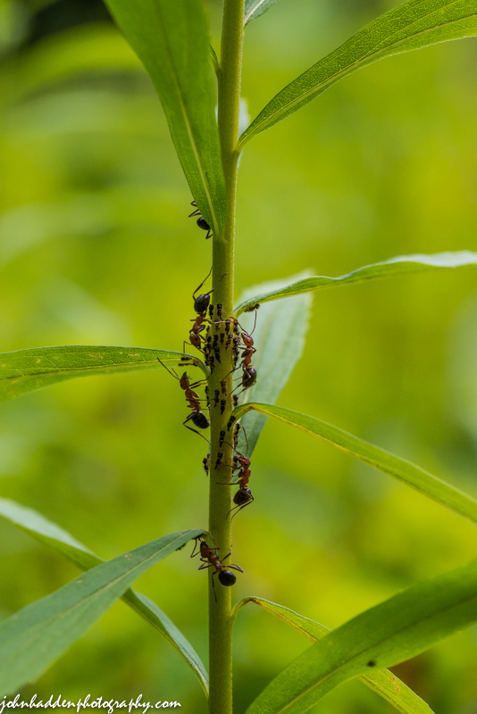
Ant aphid farming in the front field.
Morning Observation:
This morning in Huntington at 6:55AM it’s currently 60 degrees and raining moderately under overcast skies. Winds are calm. Relative humidity is 99%, dewpoint 59, barometric pressure 29.63” and rising. We picked up 0.59” of rain in the past 24hrs but none of the hail that was reported to our north and south. Yesterday’s high was 80, and the overnight low was 57.
Forecast:
A strong low pressure system and upper disturbance will bring a welcome soaking rain with embedded thunderstorms to the region today. We’ll see rain with a chance of thunderstorms throughout the day. Some thunderstorms may produce gusty winds and heavy rainfall this afternoon. Highs will be in the upper 60s with light and variable winds. Chance of rain is near 100%. Rain will continue into tonight. Lows will be in the lower 50s with northwest winds around 10 mph. Chance of rain is 90%. We should see rainfall totals in the 1″-1.5″ range before things wind down.
Tuesday should be partly sunny with a 20 chance of lingering showers. Highs will be around 70 with west winds around 10 mph. Tuesday night should be partly cloudy with lows in the lower 50s and light and variable winds.
Wednesday’s looking partly sunny with highs in the lower 70s and south winds around 10 mph. Wednesday night should be partly cloudy with lows in the mid 50s.
Almanac:
Last year on this date we had a high of 77 and lows of 57.
Burlington norms for this date are highs of 81 and lows of 60.
The record high was 96°F in 1964.
The record low was 45°F in 2001 (we had a low of 49).
Sky Notes:
Sunrise: 5:35 AM EDT
Sunset: 8:22 PM EDT
Length of Visible Light: 15h 54m
Length of Day: 14h 47m
The Moon is a waxing crescent, 1d 12h old with 2% illumination.
Moonrise: 7:20 AM EDT
Moonset: 8:55 PM EDT
About Today’s Photo:
“Aphid farming” is a well known phenomenon. Ants will “corral” groups of aphids and feed off or the sweet secretions that they produce. Studies suggest that the ants use a tranquilizer in their feet to subdue their charges and keep them gathered together. I saw three different varieties of ants out in the front field the other day farming.
Nikon D600, Sigma 105mm lens, ISO 1250, f/13, 1/500″ exposure.
Sunday, July 27, 2014

A jumping spider stalks its prey in the front field.
Morning Observation:
This morning in Huntington at 7:05AM it’s currently 63 degree under overcast skies. Winds are calm. Relative humidity is 99%, dewpoint 62, barometric pressure 29.69” and falling rapidly. We picked up 0.09” of rain overnight. Yesterday’s high was 77, and the overnight low was 56.
Forecast:
We’re into an active weather pattern for the next 46 hours courtesy of an advancing low pressure system and attendant warm and cold fronts. A line of showers and thunderstorms is currently moving across the St. Lawrence Valley of and western New York and will cross into Vermont in the next hour or two. Another batch of showers and storms will kick off later this afternoon. Highs today in the mid 70s with south winds around 10 mph. Chance of rain is 80%. Tonight should be partly cloudy until midnight, then becoming cloudy with a chance of showers and thunderstorms mainly until midnight. Lows will be in the lower 60s with south winds around 10 mph until midnight, then becoming light and variable. Chance of rain is 50%.
Monday will bring rain with a slight chance of thunderstorms throughout the day. Highs will be in the lower 70s with light and variable winds becoming northwesterly around 10 mph in the afternoon. Chance of rain is 90%. Monday night showers are likely. Lows will be in the mid 50s with west winds around 10 mph. Chance of rain is 70%.
Tuesday’s looking partly sunny with a 50% chance of lingering showers. Highs will be around 70 with west winds around 10 mph. Tuesday night should be partly cloudy with lows in the mid 50s.
Almanac:
Last year on this date we had a high of 80 and a low of 48.
Burlington norms for this date are highs of 81 and lows of 60.
The record high was 98°F in 1949.
The record low was 46°F in 2001 (we had a low of 42).
Sky Notes:
Sunrise: 5:33 AM EDT
Sunset: 8:23 PM EDT
Length of Visible Light: 15h 57m
Length of Day: 14h 49m
The Moon is a waxing crescent, 12 hours old with 0% illumination.
Moonrise: 6:22 AM EDT
Moonset: 8:26 PM EDT
About Today’s Photo:
Out hunting bugs yesterday in the front field, I came across this jumping spider making its way from leaf to leaf. It stopped only briefly enough for me to get this shot before it hopped on top of the unidentified bug right in front of it. Curiously, it hopped right off the bug immediately afterword having found, I suppose, the insect not to its liking.
Nikon D600, Sigma 105mm lens, ISO 1250, f/11, 1/640″ exposure.
Saturday, July 26, 2014

Chicory and Queen Anne’s lace up along Bert White Road
Morning Observation:
This morning in Huntington at 8:15AM it’s currently 62 degrees under hazy, partly cloudy skies. Winds are calm. Relative humidity is 98%, dewpoint 61, barometric pressure 29.90″. Yesterday’s high was 78, and the overnight low was 52.
You may have noted the hazy skies yesterday. Forest fires way out in Canada’s Northwest Territories were responsible—spreading smokey particulate across much up Canada and the norther tier of the US.
Forecast:
We’ll start the day out with partly sunny skies with highs reaching in the upper 70s and southwest winds around 10 mph. Tonight should be partly cloudy with a slight chance of showers and thunderstorms until midnight, then cloudy with showers and a chance of thunderstorms likely after midnight as a warm front crosses the region. Lows will be in the lower 60s with south winds around 10 mph. Chance of rain is 70%.
Showers will continue into Sunday as a with highs in the mid 70s and south winds around 10 mph. Chance of rain is 70%. Sunday night should be partly cloudy with a chance of showers and thunderstorms. Lows will be in the lower 60s with south winds around 10 mph. Chance of rain is 50%.
A more concentrated low pressure system and a pair of cold fronts will traverse the region Monday brining more steady rain. Highs will be in the lower 70s with north winds around 10 mph. Chance of rain is 80%. Monday night should be cloudy with a 50% chance of rain. Lows will be in the mid 50s.
Almanac:
Last year on this date we had a high of 71 and a low of 49.
Burlington norms for this date are highs of 81 and lows of 61.
The record high was 94°F in 1939.
The record low was 45°F in 1976.
Sky Notes:
Sunrise: 5:32 AM EDT
Sunset: 8:24 PM EDT
Length of Visible Light: 15h 59m
Length of Day: 14h 51m
The Moon is new, 29d 4h old with 0% illumination.
Moonrise: 5:25 AM EDT
Moonset: 7:54 PM EDT
About Today’s Photo:
It’s high summer and the chicory and Queen Anne’s lace are blooming. This shot was taken along the roadside on Bert White Road yesterday.
Sony RX100 III, ISO 125, f/2.8, 1/1600″ exposure.
Friday, July 25, 2014
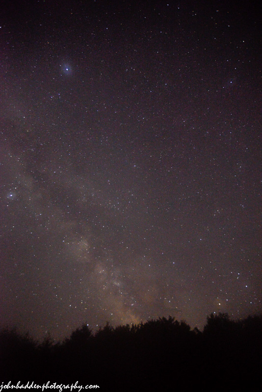
The Milky Way above our front field last night
Morning Observation:
This morning in Huntington at 6:50AM it’s currently a cool and dewy 51 degrees under clear skies. Winds are calm. Relative humidity is 99%, dewpoint 50, barometric pressure 29.96”. Yesterday’s high was comfortable 71, and the overnight low got down to 48.
Forecast:
We’ve got another primo mid-summer day on tap courtesy of broad high pressure stretching from the upper mid-West into northern New England. We’ll see mostly sunny skies today with highs in the upper 70s and light and variable winds, becoming westerly around 10 mph this afternoon. Tonight should be clear with lows in the mid 50s and light and variable winds.
Saturday should start out partly sunny with a slight chance of showers in the afternoon as an upper level disturbance approaches from the west out ahead of larger low pressure system. Highs will be in the upper 70s with southwest winds around 10 mph. Chance of rain is 20%. Saturday night showers and thunderstorms likely as the disturbance moves through. Lows will be in the lower 60s with south winds around 10 mph. Chance of rain is 70%.
Sunday showers and thunderstorms likely as the more complex low and associated fronts move through. Highs will be in the mid 70s with southwest winds around 10 mph. Chance of rain is 70%. Sunday night should be partly cloudy with a chance of showers. Lows will be around 60. Chance of rain is 50%.
Almanac:
Last year on this date we had a high of 71 and a low of 40. We picked up a trace of rain.
Burlington norms for this date are highs of 81 and lows of 61.
The record high was 97°F in 1963.
The record low was 45°F in 1912.
Sky Notes:
Sunrise: 5:31 AM EDT
Sunset: 8:25 PM EDT
Length of Visible Light: 16h 02m
Length of Day: 14h 53m
The Moon is a waning crescent 28d 2h old with 2% illumination.
Moonrise: 4:30 AM EDT
Moonset: 7:18 PM EDT
About Today’s Photo:
Last night’s clear skies offered a great view of the Milky Way. I was testing some new camera equipment for this shot looking south from next to our solar panel in the front field. I learned a lot and got some decent shots, but there’s certainly the opportunity for improvement especially by wiping the dew off the lens every now and then (which I totally forgot about, hence the fuzzy brightness of Vega in the upper left of the frame.)
Nikon D600, Nikon 18-3mmm lens @ 18mm, ISO 3200, f/3.5, 20″ exposure.
Thursday, July 24, 2014

Day lilies and bee balm at the peak in our ornamental garden
Morning Observation:
This morning in Huntington at 6:35AM it’s currently a cool 55 degrees under partly cloudy skies. Winds are calm. Relative humidity is 98%, dewpoint 54, barometric pressure 29.89” and rising rapidly. We picked up 1.09” of rain yesterday afternoon and evening—mostly in one heavy downpour between 3:00PM and 4:00PM. Yesterday’s high was 86, and the overnight low was 54.
Forecast:
High pressure is currently building into the region and will deliver another round of delightful summer days into the weekend. We’ll see partly sunny skies today with highs in the mid 70s and northwest winds 10 to 15 mph. Tonight should be clear with lows in the lower 50s and northwest winds around 10 mph until midnight, becoming light and variable.
Friday should be mostly sunny with highs in the upper 70s and southwest winds around 10 mph.Friday night should be mostly clear with lows in the lower 50s and southwest winds around 10 mph.
Saturday’s looking partly sunny and warmer as the high moves to the east once again putting us on the warm side of a southerly airflow. Highs will be around 80 with southwest winds around 10 mph. Saturday night should be partly cloudy with lows in the lower 60s. Another round of unsettled weather should move in for Sunday.
Almanac:
Last year on this date we had a high of 66 and low of 51. We picked up 0.44″ of rain.
Burlington norms for this date are highs of 81 and lows of 61.
The record high was was 95°F in 1987.
The record low was 45°F in 1912.
Sky Notes:
Sunrise: 5:30 AM EDT
Sunset: 8:26 PM EDT
Length of Visible Light: 16h 04m
Length of Day: 14h 55m
The Moon is a waning crescent, 27d 2h old with 6% illumination.
Moonrise: 3:37 AM EDT
Moonset: 6:38 PM EDT
About Today’s Photo:
Day lilies and bee balm are at their peak this time of year and our ornamental garden by the volleyball court is popping with color!
Sony RX100 III, ISO 125, f/1.8, 1/250″ exposure.
Wednesday, July 23, 2014

Indian Pipes blooming up in the woods
Morning Observation:
This morning in Huntington at 6:05AM it’s currently 66 degrees under partly cloudy skies. Winds are calm. Relative humidity is 98%, dewpoint 65, barometric pressure 29.81” and falling. Yesterday’s high was 85, and the overnight low was 65.
Forecast:
A cold front — currently out over the Great Lakes — will cross the region today and into this evening bringing scattered to numerous showers and thunderstorms. Morning radar imagery shows showers stretching from Indianapolis up to Buffalo with some scattered showers up to Ottawa. We’ll see mostly sunny skies with scattered thunderstorms and a chance of showers this morning, then mostly cloudy skies with numerous showers and thunderstorms this afternoon. Some thunderstorms may produce gusty winds and heavy rainfall this afternoon. Highs will be in the lower 80s with south winds around 10 mph, becoming westerly this afternoon. Chance of rain is 70%. Tonight should be mostly cloudy with scattered showers and isolated thunderstorms until midnight, then becoming partly cloudy after midnight. It’ll be cooler overnight with lows in the mid 50s and light and variable winds. Chance of rain is 50%.
High pressure will bring cooler and drier conditions to the region Thursday with partly sunny skies and highs in the mid 70s with north winds around 10 mph. Thursday night should be clear with lows in the lower 50s and west winds around 10 mph.
Friday’s looking mostly sunny with highs in the upper 70s and southwest winds around 10 mph. Friday night should be mostly clear with lows in the mid 50s. The next chance of rain looks to be late Sunday at this point.
Almanac:
Last year on this date we had a high of 80 and a low of 63. We picked up 0.25″ of rain.
Burlington norms for this date are highs of 81 and lows of 61.
The record high was 93°F in 1952.
The record low was 46°F in 1923.
Sky Notes:
Sunrise: 5:29 AM EDT
Sunset: 8:27 PM EDT
Length of Visible Light: 16h 06m
Length of Day: 14h 58m
The Moon is a waning crescent, 26d 2h old with 11% illumination.
Moonrise: 2:47 AM EDT
Moonset: 5:53 PM EDT
About Today’s Photo:
Indian pipes (Monotropa uniflora) are common in our area but not all that common as flowers go in that they’re one of the few that have no chlorophyl and thus don’t photosynthesize. Instead they have a complex parasitic relationship with certain fungi that grow on the shady forest floor and get their nutrients directly from the humus. You can read more about Indian pipes here.
Sony RX100 III, ISO 200, f/2, 1/30″ exposure.
Tuesday, July 22, 2014

A lovely rose by the studio stairs
Morning Observation:
This morning in Huntington at 6:35AM it’s currently 61 degrees under a hazy clear sky. Winds are calm. Relative humidity is 98%, dewpoint 60, barometric pressure 30.08”. Yesterday’s high was 84, and the overnight low was 60.
Forecast:
With high pressure sliding to our east and a cold front approaching from the west, we’ll be squarely in the path of a warm and humid southerly airflow today. We’ll see mostly sunny skies with highs in the mid 80s to 90 in broader valleys. Winds will be light and variable, becoming southwesterly around 10 mph this afternoon. Tonight should be clear and muggy with lows in the upper 60s and dewpoints not much lower. Winds will be light and variable winds, becoming southerly around 10 mph after midnight.
Wednesday should start off mostly sunny with a chance of showers and thunderstorms in the morning, then become mostly cloudy with showers and thunderstorms likely in the afternoon as the cold front moves into the region. Some thunderstorms may produce gusty winds and heavy rainfall in the afternoon. It’ll be humid with highs in the lower 80s and southwest winds 10 to 15 mph gusting up to 25 mph. Chance of rain is 70%. Wednesday night should be partly cloudy with a chance of showers and thunderstorms. Lows will be in the mid 50s with northwest winds around 10 mph. Chance of rain is 50%.
Cooler and drier air will move in behind the departing cold front on Thursday brining mostly sunny skies with highs in the lower 70s and northwest winds around 10 mph. Thursday night should be mostly clear with lows in the lower 50s.
Almanac:
Last year on this date we had a high of 82 and a low of 51.
Burlington norms for this date are highs of 81 and lows of 61.
The record high was 97°F in 1955.
The record low was 44°F in 1914.
Sky Notes:
Sunrise: 5:28 AM EDT
Sunset: 8:27 PM EDT
Length of Visible Light: 16h 07m
Length of Day: 14h 58m
Tomorrow will be 1m 58s shorter.
The Moon is a waning crescent, 25d 2h old with 18% illumination.
Moonrise: 2:01 AM EDT
Moonset: 5:01 PM EDT
About Today’s Photo:
Roses love the warm weather and the bush by the studio stairs is certainly showing it. It’s blooming prolifically this year.
Nikon D600, Sigma 105mm lens, ISO 800, f/11, 1/250″ exposure.
Monday, July 21, 2014

Red astilbe pops in our back garden.
Morning Observation:
This morning in Huntington at 6:40AM it’s currently 55 degrees under clear skies. Winds are calm. Relative humidity is 98%, dewpoint 55, barometric pressure 30.15” and rising. Yesterday’s high was 79, and the overnight low was 54.
Forecast:
Surface high pressure will slide east of our region today putting us on the warm side of a southerly airflow. Consequently we’ll see increasing temperatures and humidity over the next couple of days. We’ll see partly sunny skies today with a slight chance of showers and thunderstorms this afternoon over the ‘Dacks and northern Vermont. Highs will be in the lower 80s with light and variable winds, becoming southerly around 10 mph this afternoon. Chance of rain is 20%. Tonight should be partly cloudy with lows in the lower 60s and light and variable winds.
Tuesday should be mostly sunny and warmer with highs in the mid 80s and light and variable winds, becoming southwesterly around 10 mph in the afternoon. Tuesday night should be mostly clear and muggy with lows in the mid 60s and south winds around 10 mph.
A cold front will move into the region on Wednesday kicking off occasional showers and thunderstorms in the afternoon. It’ll be humid with highs in the mid 80s and southwest winds 10 to 15 mph. Chance of rain is 80%. Wednesday night showers and thunderstorms are likely. Lows will be in the upper 50s. Chance of rain is 70%.
Almanac:
Last year on this date we had a high of 76 and a low of 53. We picked up 0.22″ of rain.
Burlington norms for this date are highs of 81 and lows of 61.
The record high was was 97°F in 2011 (we had a high of 93).
The record low was 45°F in 1966.
Sky Notes:
Sunrise: 5:27 AM EDT
Sunset: 8:28 PM EDT
Length of Visible Light: 16h 09m
Length of Day: 15h 00m
Tomorrow will be 1m 55s shorter.
The Moon a waning crescent, 24d 2h old with 26% illumination.
Moonrise: 1:19 AM EDT
Moonset: 4:06 PM EDT
About Today’s Photo:
It’s a good year for astilbe this summer, at least around our house! We have several varieties planted in our various gardens and they’re all very lush this year.
Nikon D600, Sigma 105mm lens, ISO 1250, f/11, 1/160″ exposure.
Sunday, July 20, 2014

Fireweed blooming along Taft Road.
Morning Observation:
This morning in Huntington at 7:15AM it’s currently 57 degrees under partly cloudy skies. Winds are calm. Relative humidity is 99%, dewpoint 57, barometric pressure 30.17″. Yesterday’s high was 78, and the overnight low was 54.
Forecast:
High pressure continues to dominate the region. We’ll enjoy another nice summer day today of partly sunny skies with highs in the upper 70s and light and variable winds, becoming southerly around 10 mph this afternoon. Tonight should be partly cloudy with lows in the mid 50s and light and variable winds.
The temperature and humidity will begin climbing through the middle of the upcoming work week courtesy of a southerly airflow. We’ll see partly sunny skies Monday with highs in the lower 80s and light and variable winds. Monday night should be partly cloudy with lows in the lower 60s and light and variable winds.
Tuesday’s looking partly sunny with highs in the mid 80s and light and variable winds. Tuesday night should be mostly clear with lows in the mid 60s.
Almanac:
Last year on this date we had a high of 81 and a low of 62. We picked up 0.24″ of rain.
Burlington norms for this date are highs of 81 and lows of 61.
The record high was 99°F in 1977.
The record low was 43°F in 1929.
Sky Notes:
Sunrise: 5:26 AM EDT
Sunset: 8:29 PM EDT
Length of Visible Light: 16h 12m
Length of Day: 15h 02m
Tomorrow will be 1m 53s shorter.
The Moon is a waning crescent, 23d 3h old with 35% illumination.
Moonrise: 12:41 AM EDT
Moonset: 3:06 PM EDT
About Today’s Photo:
Fireweed is a tall and prolific plant that blooms along roadways and disturbed areas. This was one of many stems up along Taft Road.
Nikon D600, Sigma 105mm lens, ISO 400, f/3, 1/4000″ exposure.
Saturday, July 19, 2014

Wood sorrel blooming along the Long Trail near Camel’s Hump
Morning Observation:
This morning in Huntington at 7:15AM it’s currently 54 degrees under a milky sky. Winds are calm. Relative humidity is 98%, dewpoint 53, barometric pressure 30.26″. Yesterday’s high was 78, and the overnight low was 51.
Forecast:
Dry and seasonably warm conditions continue courtesy of high pressure parked over the region. We’ll see partly sunny skies today with highs in the upper 70s and light and variable winds. Tonight should be partly cloudy with lows in the mid 50s and light and variable winds.
Sunday should be partly sunny with highs in the upper 70s and light and variable winds, becoming southerly around 10 mph in the afternoon. Sunday night should be partly cloudy with lows in the upper 50s and light and variable winds.
Monday’s looking partly sunny with highs in the lower 80s and light and variable winds. Monday night should be mostly clear with lows in the mid 60s.
Almanac:
Last year on this date we had a high of 90 and a low of 67. We picked up 0.10″ of rain.
Burlington norms for this date are highs of 81 and lows of 61.
The record high was 98°F in 2013 (we had a high of 90).
The record low was 48°F in 1929.
Sky Notes:
Sunrise: 5:25 AM EDT
Sunset: 8:30 PM EDT
Length of Visible Light: 16h 14m
Length of Day: 15h 04m
Tomorrow will be 1m 50s shorter.
The Moon is a waning crescent, 22d 3h old with 46% illumination.
Moonrise: 12:06 AM EDT
Moonset: 2:03 PM EDT
About Today’s Photo:
The wood sorrel is in bloom along higher elevation trails this time of year. This flower was along the Long Trail just south of the summit of Camel’s Hump. The clover-like leaves and stems of the sorrel make for a tangy and refreshing snack as your hiking, and I’ve called it “trail lettuce” for years.
Sony RX100 II, ISO 800, f/8, 1/30″ exposure.
Friday, July 18, 2014

A peachy day lily in our front yard
Morning Observation:
This morning in Huntington at 6:55AM it’s currently 52 degrees under partly cloudy skies. Winds are calm. Relative humidity is 98%, dewpoint 51, barometric pressure 30.17″ and rising slowly. Yesterday’s high was 73, and the overnight low was 49.
Forecast:
We’ve got another great summer weekend on tap courtesy of high pressure that is currently building into the region. We’ll see sunny skies today with highs in the upper 70s and light and variable winds. Tonight should be clear with lows in the lower 50s and light and variable winds.
Saturday should be partly sunny with highs in the lower 80s and light and variable winds. Saturday night should be partly cloudy with lows in the mid 50s and light and variable winds.
Sunday’s looking partly sunny with highs around 80 and light and variable winds. Sunday night should be partly cloudy as a weak upper level disturbance approaches from the southwest. Lows will be in the upper 50s.
Almanac:
Last year on this date we had a high of 87 and a low of 46.
Burlington norms for this date are highs of 81 and lows of 61.
The record high was 99°F in 1953.
The record low was 47°F in 1956.
Sky Notes:
Sunrise: 5:24 AM EDT
Sunset: 8:31 PM EDT
Length of Visible Light: 16h 16m
Length of Day: 15h 06m
Tomorrow will be 1m 47s shorter.
The Moon is in its last quarter, 21d 2h old with 57% illumination.
No Moon Rise
Moonset: 12:56 PM EDT
About Today’s Photo:
Lovely day lilies are in bloom this time of year. This peachy variety grows around the Korean mountain ash in our front yard.
Nikon D600, Sigma 105mm lens, ISO 800, f/16, 1/320″ exposure.
Thursday, July 17, 2014

A loon takes a morning bath in Green River Reservoir
Morning Observation:
This morning in Huntington at 5:55AM it’s currently a cool 49 degrees under clear skies. Winds are calm. Relative humidity is 98%, dewpoint 49, barometric pressure 29.91” and rising. Yesterday’s high was 78, and the overnight low was 49.
Forecast:
An upper level trough of low pressure will gradually move across the region today bringing a chance of a few showers this afternoon and evening. We’ll see mostly sunny skies with a slight chance of showers this afternoon. Highs will be in the mid 70 with light and variable winds, becoming northwesterly around 10 mph this afternoon. Chance of rain is 20%. Tonight should be partly cloudy until midnight, then clearing. Lows will be in the lower 50s with west winds around 10 mph until midnight, becoming light and variable.
Friday should be sunny with highs in the upper 70s and light and variable winds, becoming northwesterly around 10 mph in the afternoon. Friday night should be clear with lows in the mid 50s and northeast winds around 10 mph.
Saturday’s looking sunny with highs in the lower 80s and light and variable winds. Saturday night should be mostly clear the lows in the upper 50s.
Almanac:
Last year on this date we had a high of 90 and a low of 63.
Burlington norms for this date are highs of 81 and lows of 61.
The record high was 97°F in 1999 (we had a high of 93).
The record low was 47°F in 1908.
Sky Notes:
Sunrise: 5:23 AM EDT
Sunset: 8:31 PM EDT
Length of Visible Light: 16h 18m
Length of Day: 15h 08m
Tomorrow will be 1m 43s shorter.
The Moon is waning gibbous, 20d 1h old with 68% illumination.
Moonrise: 11:33 PM EDT
Moonset: 11:47 AM EDT
About Today’s Photo:
Robin & I took a paddle up at Green River Reservoir the other day. The reservoir is a prime nesting area for common loons, and this one was splashing and having a nice preening session as we paddled by. He was quite tame and allowed us to get pretty close.
Sony RX100 II, 31mm, ISO 160, f/5.6, 1/160″ exposure.
Wednesday, July 16, 2014

Mountain sandwort blooming near the summit of Camel’s Hump
Morning Observation:
This morning in Huntington at 6:20AM it’s currently 62 degrees and raining lightly under overcast skies. Winds are calm. Relative humidity is 98%, dewpoint 62, barometric pressure 29.75” and rising slowly. We picked up 0.20” of rain in the past 24hrs. Yesterday’s high was 79, and the overnight low was 62.
Forecast:
This morning’s showers should come to an end as the cold front responsible for them pushes east of our region to be replaced by cooler, drier air. We’ll see cloudy skies with a slight chance of showers this morning, then partly sunny skies this afternoon. Highs will be in the mid 70s with light and variable winds, becoming westerly around 10 mph this afternoon. Chance of rain is 20%. Tonight should be partly cloudy with lows in the mid 50s and west winds around 10 mph until midnight, becoming light and variable.
Thursday should be partly sunny with a slight chance of showers in the afternoon as diurnal heating interacts with mild instability. Highs will be in the mid 70s with light and variable winds, becoming northwesterly around 10 mph in the afternoon. Chance of rain is 20%. Thursday night should be mostly clear with lows in the lower 50s and light and variable winds.
Friday’s looking sunny with highs in the upper 70s and southwest winds around 10 mph. Friday night should be clear with lows in the mid 50s.
Almanac:
Last year on this date we had a high of 87 and lows of 62.
Burlington norms for this date are highs of 81 and lows of 61.
The record high was 94°F in 1969.
The record low was 44°F in 1946.
Sky Notes:
Sunrise: 5:22 AM EDT
Sunset: 8:32 PM EDT
Length of Visible Light: 16h 20m
Length of Day: 15h 09m
Tomorrow will be 1m 41s shorter.
The Moon is waning gibbous, 19d 2h old with 78% illumination.
Moonrise: 11:00 PM EDT
Moonset: 10:36 AM EDT
About Today’s Photo:
Mountain Sandwort is a true alpine flower that grows in Vermont only on our highest summits. It’s in full bloom right now, and there are carpets of it up on the summit of Camel’s Hump. If you go up to take a look, remember to stay on the rocks as the flowers and sedges of our alpine summits are rare and endangered!
Sony RX100II, ISO 160, f/11, 1/125″ exposure.
Tuesday, July 15, 2014

A pair of black-eyed Susans in the front field
Morning Observation:
This morning in Huntington at 7:00AM it’s currently 69 degrees under mostly cloudy skies. Winds are calm. Relative humidity is 98%, dewpoint 68, barometric pressure 29.75”. We picked up 0.08” of rain in the past 24hrs. Yesterday’s high was 81, and the overnight low was 61.
Forecast:
A humid air mass will remain in place across the region today and tonight. A strong upper level low and attendant cold front will shift eastward across the Great Lakes during the day today. As the low approaches, showers and thunderstorms will become increasingly widespread. We’ll see partly sunny skies with a chance of showers and a slight chance of thunderstorms this morning, then mostly cloudy skies with showers and thunderstorms this afternoon. Some thunderstorms may produce gusty winds and heavy rainfall this afternoon. Highs will be in the upper 70s with light and variable winds, becoming southerly around 10 mph this afternoon. Chance of rain is 90%. Showers and thunderstorms will continue this evening until midnight, then showers are likely after midnight. Lows will be in the lower 60s with south winds around 10 mph until midnight, becoming light and variable. Chance of rain is 90%.
Wednesday should be cloudy with a chance of showers in the morning, then become partly sunny with a slight chance of showers in the afternoon cooler, drier air moves in behind the departing low. Highs will be in the mid 70s with light and variable winds, becoming southwesterly around 10 mph in the afternoon. Chance of rain is 40%. Wednesday night should be mostly clear. Lows will be in the mid 50s with west winds around 10 mph.
Thursday’s looking partly sunny with highs in the mid 70s and west winds around 10 mph. Thursday night should be mostly clear with lows in the mid 50s.
Almanac:
Last year on this date we had a high of 90 and a low of 65.
Burlington norms for this date are highs of 81 and lows of 61.
The record high was 96°F in 1995.
The record low was 45°F in 1940.
Sky Notes:
Sunrise: 5:22 AM EDT
Sunset: 8:33 PM EDT
Length of Visible Light: 16h 21m
Length of Day: 15h 11m
Tomorrow will be 1m 37s shorter.
The Moon is waning gibbous, 18d 3h old with 87% illumination.
Moonrise: 10:27 PM EDT
Moonset: 9:23 AM EDT
About Today’s Photo:
This lovely pair of black-eyed Susans were posing nicely for me in the front field.
Nikon D600, Sigma 105mm lens, circular polarizer, ISO 1250, f/7.1, 1/125″ exposure.
Monday, July 14, 2014
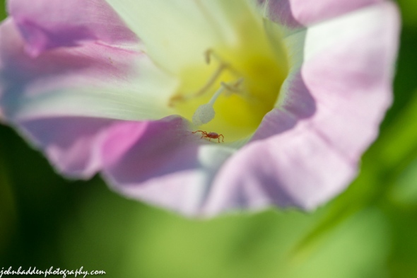
A tiny red spider mite prowls the inside of a morning glory
Morning Observation:
This morning in Huntington at 6:20AM it’s currently 59 degrees under clear skies. Winds are calm. Relative humidity is 99%, dewpoint 59, barometric pressure 29.84” and rising. We picked up 0.15” of rain in the past 24hrs. Yesterday’s high was 77, and the overnight low was 59.
Forecast:
The frontal boundary which brought showers to the region yesterday will continue to slowly move eastward across the region today. Drier air behind the front will make for a generally rain-free day, with just a slight chance for a few showers or isolated thunderstorm across central to southeast Vermont. We’ll see sunny skies this morning, then partly sunny skies with a slight chance of showers and thunderstorms this afternoon. Highs will be in the upper 70s with light and variable winds, becoming southwesterly around 10 mph this afternoon. Chance of rain is 205. Tonight should be partly cloudy until midnight, then becoming cloudy with a chance of thunderstorms and showers until midnight. Lows in the lower 60s with light and variable winds. Chance of rain is 40%.
An upper level low pressure system currently out over the western Great Lakes will move in on Tuesday brining showers and a chance of thunderstorms in the afternoon. Highs will be in the upper 70s with light and variable winds, becoming southerly around 10 mph in the afternoon. Chance of rain is 70%. Tuesday night showers are likely with a chance of thunderstorms. Lows will be in the lower 60s with light and variable winds. Chance of rain is 70%.
Wednesday’s looking partly sunny with highs in the mid 70s and west winds around 10 mph. Wednesday night should be partly cloudy with lows in the mid 50s.
Almanac:
Last year on this date we had a high of 89 and a low of 65.
Burlington norms for this date are highs of 81 and lows of 61.
The record high was 96°F in 1948.
The record low was 46°F in 1971.
Sky Notes:
Sunrise: 5:21 AM EDT
Sunset: 8:34 PM EDT
Length of Visible Light: 16h 23m
Length of Day: 15h 12m
Tomorrow will be 1m 35s shorter.
The Moon is waning gibbous, 17d 2h old with 94% illumination.
Moonrise: 9:52 PM EDT
Moonset: 8:08 AM EDT
About Today’s Photo:
Spider mites abound out in the front field if only you get down close enough to find them. They are quite small! This one was buys prowling the interior of a morning glory blossom.
Nikon D600, Sigma 105mm lens, circular polarizing filter, ISO 650, f/13, 1/250″ exposure.
Sunday, July 13, 2014

What’s up with this fly…?
Morning Observation:
This morning in Huntington at 8:05AM it’s currently 73 degrees under mostly cloudy skies. Winds are out of the south at 0-3 mph. Relative humidity is 82%, dewpoint 68, barometric pressure 29.91″ and falling. Yesterday’s high was 84 and the overnight low was 64.
Forecast:
Low pressure moving through the Great Lakes region this morning will push a warm front through the region this mornings followed by a cold front tonight. We’ll see cloudy skies with a chance of showers this morning, then showers and thunderstorms are likely this afternoon. Highs will be in the upper 70s with south winds 10 to 15 mph gusting up to 25 mph. Chance of rain is 70%. Tonight should be mostly cloudy with showers and thunderstorms likely mainly until midnight. Lows will be in the mid 60s with south winds 15 to 20 mph gusting up to 30 mph, then becoming southwesterly around 10 mph after midnight. Chance of rain is 70%.
Monday should be partly sunny with a slight chance of showers in the morning, then a chance of showers and thunderstorms in the afternoon. Highs will be in the upper 70s with southwest winds around 10 mph. Chance of rain is 30%. Monday night should be partly cloudy with a chance of showers and thunderstorms. Lows will be in the lower 60s with light and variable winds. Chance of rain is 40%.
Tuesday’s looking mostly cloudy with a chance of showers and thunderstorms. Highs will be in the mid 70s with southwest winds around 10 mph. Chance of rain is 50%. Tuesday night should be partly cloudy with a chance of showers. Lows will be in the upper 50s. Chance of rain is 50%.
Almanac:
Last year on this date we had a high of 81 and a low of 54.
Burlington norms for this date are highs of 81 and lows of 61.
The record high was 96°F in 1995.
The record low was 45°F in 1940.
Sky Notes:
Sunrise: 5:20 AM EDT
Sunset: 8:34 PM EDT
Length of Visible Light: 16h 25m
Length of Day: 15h 14m
Tomorrow will be 1m 31s shorter.
The Moon is waning gibbous, 16d 4h old with 98% illumination.
Moonrise: 9:14 PM EDT
Moonset: 6:52 AM EDT
About Today’s Photo:
In my bug hunting out in the front field the other day, I came across this fly that was seemingly being stuck in a milkweed flower. Curious I thought… Perhaps it’s just my aging eyes, but it took me until I came back in the house, loaded the shots into my computer and zoomed in really closely that I saw the crab spider chomping down on the hapless insect. The spider’s perfect camouflage completely disguised it to me, and, apparently, the fly! Ah, the wonders of nature!
Nikon D600, Sigma 105mm lens, circular polarizing filter, ISO 1250, f/13, 1/320″ exposure.
Saturday, July 12, 2014

Ripening grasses in the front field
Morning Observation:
This morning in Huntington at 6:55AM it’s currently 53 degrees under clear skies. Winds are calm. Relative humidity is 99%, dewpoint 53, barometric pressure 30.19″. Yesterday’s high was 77, and the overnight low was 50.
Forecast:
We’ve got another lovely summer day on tap courtesy of high pressure sitting over the region this morning. We’ll see mostly sunny skies with highs in the lower 80s and light and variable winds, becoming southwesterly around 10 mph this afternoon. Tonight should be partly cloudy with lows in the mid 60s and light and variable winds.
A warm front will move into the region Sunday bringing cloudy skies and a chance of showers with a slight chance of thunderstorms in the morning, then showers likely with a chance of thunderstorms in the afternoon. Highs will be in the mid 70s with south winds around 10 mph. Chance of rain is 70%. A cold front will shift into the region Sunday night bringing more showers with a chance of thunderstorms. Lows will be in the mid 60s with south winds around 10 mph. Chance of rain is 70%.
Monday’s looking partly sunny with a chance of showers. Highs will be in the upper 70s with southwest winds around 10 mph. Chance of rain is 50%. Monday night should be partly cloudy with a chance of showers. Lows will be in the lower 60s. Chance of rain is 40%.
Almanac:
Last year on this date we had a high of 78 and a low of 52.
Burlington norms for this date are highs of 81 and lows of 61.
The record high was 96°F in 1948.
The record low was 46°F in 1971.
Sky Notes:
Sunrise: 5:19 AM EDT
Sunset: 8:35 PM EDT
Length of Visible Light: 16h 27m
Length of Day: 15h 15m
Tomorrow will be 1m 27s shorter.
The Moon is the full “Buck” moon (Northeast Native American), 15d 2h old with 100% illumination.
Moonrise: 8:30 PM EDT
Moonset: 5:39 AM EDT
Other names for this month’s full moon include: “Summer” (Colonial American), “Hay” (English), “Claiming” (Celtic), “Mead” (Medieval Wiccan), and “Rose” (Neo Pagan Wiccan).
About Today’s Photo:
Sometimes just a simple shot of ripening grasses hits the spot…
Nikon D600, Sigma 105mm lens, ISO 400, f/4.5, 1/4000″ exposure.
Friday, July 11, 2014

Devil’s Paintbrush in our front field
Morning Observation:
This morning in Huntington at 5:55AM it’s currently a cool 46 degrees under clear skies. Winds are calm. Relative humidity is 98%, dewpoint 45, barometric pressure 30.22” and rising. Yesterday’s high was 74, and the overnight low was 46.
Forecast:
A ridge of high pressure is currently over the region and will continue to deliver a couple of more fine summer days. We’ll see sunny skies today with highs in the upper 70s and light and variable winds. Tonight should be clear with lows in the lower 50s and light and variable winds.
Saturday should be mostly sunny and warmer with highs in the lower 80s and light and variable winds, becoming southerly around 10 mph in the afternoon. Saturday night should be partly cloudy with lows in the lower 60s and light and variable winds.
A low pressure system will approach the region Sunday bringing showers. Highs will be in the upper 70s with south winds 10 to 15 mph gusting up to 35 mph. Chance of rain is 70%. Sunday night showers are likely. Lows will be in the mid 60s. Chance of rain is 70%.
Almanac:
Last year on this date we had a high of 78 and low of 57. We picked up 0.58″ of rain.
Burlington norms for this date are highs of 81 and lows of 60.
The record high was 96°F in 1911.
The record low was 48°F in 1968 (guess we broke that record here in Huntington this morning…)
Sky Notes:
Sunrise: 5:18 AM EDT
Sunset: 8:36 PM EDT
Length of Visible Light: 16h 28m
Length of Day: 15h 17m
Tomorrow will be 1m 24s shorter.
The Moon is waxing gibbous, 14d 1h old with 98% illumination.
Moonrise: 7:40 PM EDT
Moonset: 4:30 AM EDT
About Today’s Photo:
Devil’s paintbrush (a.k.a. orange hawkweed) is in bloom in our front field.
Nikon D600, Sigma 105mm lens, ISO 400, f/13, 1/600″ exposure.
Thursday, July 10, 2014

Brown knapweed along the Lamoille River
Morning Observation:
This morning in Huntington at 6:40AM it’s currently 51 degrees under clear skies. Winds are calm. Relative humidity is 98%, dewpoint 51, barometric pressure 30.04” and rising rapidly. We picked up 0.03” of rain in the past 24hrs. Yesterday’s high was 79, and the overnight low was 50.
Forecast:
High pressure will build overhead today and remain over region into Saturday. We’ll see mostly sunny skies with highs in the mid 70s and west winds around 10 mph. Tonight should be clear with lows around 50 and light and variable winds.
Friday should be sunny with highs in the upper 70s and light and variable winds. Friday night should be clear with lows in the mid 50s and light and variable winds.
Saturday’s looking mostly sunny with highs in the lower 80s and south winds around 10 mph. Saturday night should be partly cloudy with a 30% chance of showers as the next weather maker approaches the region. Lows will be in the lower 60s.
Almanac:
Last year on this date we had a high of 80 and a low of 64.
Burlington norms for this date are highs of 81 and lows of 60.
The record High was 96°F in 1911.
The record low was 45°F in 1942.
Sky Notes:
Sunrise: 5:17 AM EDT
Sunset: 8:36 PM EDT
Length of Visible Light: 16h 30m
Length of Day: 15h 18m
Tomorrow will be 1m 21s shorter.
The Moon is waxing gibbous, 13d 2h old with 94% illumination.
Moonrise: 6:44 PM EDT
Moonset: 3:29 AM EDT
About Today’s Photo:
Brown knapweed sports an almost thistle-like flower, but the stem lacks the spines. It grows prolifically in fields and along roadways. This bunch was along the Lamoille River in Jeffersonville.
Nikon D600, Nikon 24-120mm lens @ 75mm, ISO 1000, f/4, 1/1600″ exposure.
Wednesday, July 9, 2014

Day lilies blooming up along Texas Hill Road
Morning Observation:
This morning in Huntington at 6:25AM it’s currently 66 degrees under mostly clear skies. Winds are calm. Relative humidity is 87%, dewpoint 62, barometric pressure 29.65”. We picked up 0.35” of rain during the thunderstorms that rolled through here at around 10:00PM last night. Quite the lightning display! Yesterday’s high was 85, and the overnight low was 64.
Forecast:
We’re heading towards drier and cooler conditions for the next several days. However, a cold front will swing through the region later today which will likely be enough to set off a few showers and perhaps a couple of thunderstorms this afternoon and into this evening. We’ll see partly sunny skies with a chance of showers and thunderstorms this afternoon. Highs will be in the upper 70s with southwest winds 15 to 20 mph. Chance of rain is 50%. Tonight should be mostly cloudy with a chance of showers and thunderstorms until midnight, then become partly cloudy after midnight. Lows will be in the mid 50s with southwest winds 10 to 15 mph. Chance of rain is 50%.
Thursday should be mostly sunny with highs in the lower 70s and west winds around 10 mph. Thursday night should be clear with lows in the lower 50s and north winds around 10 mph.
Friday’s looking mostly sunny with highs in the upper 70s and light and variable winds. Friday night should be clear with lows in the upper 50s.
Almanac:
Last year on this date we had a high of 85 and a low of 62. We picked up 0.21″ of rain, finally ending the 17 straight days of measurable precipitation that started on 6/23/13.
Burlington norms for this date are highs of 81 and lows of 60.
The record high was 97°F in 1988.
The record low was 44°F in 1969.
Sky Notes:
Sunrise: 5:17 AM EDT
Sunset: 8:37 PM EDT
Length of Visible Light: 16h 31m
Length of Day: 15h 19m
Tomorrow will be 1m 16s shorter.
The Moon is waxing gibbous, 12d 2h old with 87% illumination.
Moonrise: 5:42 PM EDT
Moonset: 2:36 AM EDT
About Today’s Photo:
This particular spot along Texas Hill Road is a favorite of mine for views of Camel’s Hump—especially in the fall. However, something else caught my eye there the other day…
Nikon D600, Nikon 50mm lens, ISO 200, f/1.8, 1/1200″ exposure.
Tuesday, July 8, 2014

Chicory in bloom along Camel’s Hump Road
Morning Observation:
This morning in Huntington at 6:40AM it’s currently 64 degrees under clear skies. Winds are calm. Relative humidity is 98%, dewpoint 63, barometric pressure 29.67”. We picked up 0.04” of rain in the past 24hrs. Yesterday’s high was 75, and the overnight low was 63.
Forecast:
A southwesterly flow of warm and humid air will prevail today. High temperatures well into the 80s will fuel thunderstorm development ahead of a cold front which will pass through the area late tonight. We’ll see partly sunny skies with a chance of showers and thunderstorms this afternoon. Some thunderstorms may produce gusty winds small hail and heavy rainfall this afternoon. It’ll be warmer with highs in the mid 80s and southwest winds 10 to 15 mph. Chance of rain is 50%. Tonight should bring occasional showers and thunderstorms, mainly until midnight. Lows will be in the mid 60s with south winds 10 to 15 mph. Chance of rain is 80%.
Wednesday should start out mostly cloudy in the morning, then becoming partly sunny with a chance of showers and a slight chance of thunderstorms in the afternoon as an upper level disturbance swings through. Highs will be in the upper 70s with southwest winds 10 to 15 mph. Chance of rain is 30%. Wednesday night should be partly cloudy with lows in the mid 50s and west winds around 10 mph.
High pressure will build in Thursday bringing partly sunny skies with highs in the mid 70s and west winds around 10 mph. Thursday night should be mostly clear with lows in the mid 50s.
Almanac:
Last year on this date we had a high of 79 and a low of 68. We picked up 0.08″ of rain.
Burlington norms for this date are highs of 81 and lows of 60.
The record high was 98°F in 1921.
The record low was 40°F in 1969.
Sky Notes:
Sunrise: 5:16 AM EDT
Sunset: 8:37 PM EDT
Length of Visible Light: 16h 33m
Length of Day: 15h 21m
Tomorrow will be 1m 13s shorter.
The Moon is waxing gibbous, 11d 2h old with 79% illumination.
Moonrise: 4:37 PM EDT
Moonset: 1:52 AM EDT
About Today’s Photo:
The chicory is in bloom along roadsides and in fields. I love its particular shade of blue.
Nikon D600, Nikon 50mm lens. ISO 50, f/1.8, 1/1600″ exposure
