Saturday, February 28, 2015
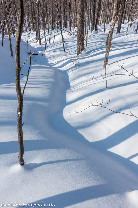
Shadows bend and tuck across a snow covered stream
Morning Observation:
This morning in Huntington at 7:20AM it’s currently -8 degrees under clear skies. Winds are calm. Relative humidity is 85%, dewpoint -11, barometric pressure 30.75” and rising. We have 20” of snow at the stake. Yesterday’s high was a lovely 21, and the overnight low was -10.
Forecast:
High pressure continues to build into the region this morning and will bring us sunny skies this morning, then partly sunny skies this afternoon. Highs will rebound much like they did yesterday into the lower 20s with southwest winds around 10 mph. Tonight should be partly cloudy and less chilly with lows around 4 above with southwest winds around 10 mph until midnight, becoming light and variable.
Sunday should start out partly sunny in the morning, then become mostly cloudy with a 40% of snow in the afternoon as a low pressure wave approaches from the Ohio River valley. Highs will be in the upper 20s with south winds around 10 mph. Snow will continue into Sunday night with light snow accumulations on the order of 2-3″ possible. Lows will be around 17 with southwest winds 10 to 15 mph. Chance of snow is 80%.
Monday should be cloudy with a 50% chance of lingering snow showers. Highs will be in the upper 20s with northwest winds 15 to 20 mph gusting up to 30 mph. Monday night should be partly cloudy and chilly with lows around zero.
Almanac:
Last year on this date we had a high of 17 and a low of -10. We picked up 1.25″ of new snow and had 15″ at the stake.
Burlington norms for this date are highs of 34 and lows of 16.
The record high was 55°F in 1903.
The record low was -17°F in 1920.
Sky Notes:
Sunrise: 6:31 AM EST
Sunset: 5:38 PM EST
Length of Visible Light: 12h 05m
Length of Day: 11h 07m
Tomorrow will be 3m1s longer.
The Moon is waxing gibbous, 9d 12h old with 77% illumination.
Moonrise: 1:11 PM EST
Moonset: 3:15 AM EST
About Today’s Photo:
As I’m out on the snow these days, I find myself captivated by shadows in the bright sunlight. I love the subtle curves…
Friday, February 27, 2015

Drifted snow and shadows up near Crow Hill
Morning Observation:
This morning in Huntington at 6:35AM it’s currently -11 degrees under mostly clear skies. Winds are calm. Relative humidity is 84%, dewpoint -15, barometric pressure 30.36” and rising rapidly. We have 20” of snow at the stake. Yesterday’s high was 13, and the overnight low was -11.
Forecast:
Arctic high pressure is currently building into the region and will deliver cold and quiet weather through early Sunday. We’ll see partly sunny skies with highs around 12 today with light and variable winds, becoming northwesterly around 10 mph this afternoon. Tonight should be partly cloudy and cold with lows around -3 below with light and variable winds.
Saturday should be mostly sunny and a bit milder with highs around 19 and southwest winds around 10 mph. Saturday night should be partly cloudy with lows around 2 above and light and variable winds.
Sunday should start out partly sunny, but then become cloudy with a 40% chance of snow as a weak area of low pressure moves in from the Great Lakes. Highs will be in the mid 20s with south winds around 10 mph. Sunday night snow likely with light overnight snow accumulations possible. Lows will be seasonable (haven’t used that word too much this winter…) at around 20. Chance of snow is 70%.
Almanac:
Last year on this date we had a high of 22 and a low of -4. We had 14″ of snow on the ground.
Burlington norms for this date are highs of 34 and lows of 16.
The record high was 57°F in 2000 (we had a high of 61).
The record low was -21°F in 1963.
Sky Notes:
Sunrise: 6:33 AM EST
Sunset: 5:37 PM EST
Length of Visible Light: 12h 02m
Length of Day: 11h 04m
Tomorrow will be 3m1s longer.
The Moon is waxing gibbous, 8d 11h old with 68% illumination.
Moonrise: 12:18 PM EST
Moonset: 2:27 AM EST
About Today’s Photo:
The texture of the snow in the woods is luscious right now. With a good 3 feet of coverage and a creamy texture, it makes for divine backcountry skiing!
Thursday, February 26, 2015

Bear claw marks on a beech tree up near Bald Hill
Morning Observation:
This morning in Huntington at 8:00AM it’s currently 2 degrees under overcast skies. Winds are calm. Relative humidity is 80%, dewpoint -3, barometric pressure 30.14” and steady. We picked up just the barest dusting of snow in the past 24hrs and have 20” at the stake. Yesterday’s high was 26, and the overnight low was -4.
Forecast:
Surface high pressure will ridge over the region today through Saturday night bringing dry weather and below normal temperatures. We’ll see partly sunny skies today with highs only around 9 above with north winds 10 to 15 mph. Tonight should be partly cloudy and cold with lows -2 below to -8 below zero with northwest winds around 10 mph until midnight, becoming light and variable.
Friday should be mostly sunny with highs around 10 above and light and variable winds. Friday night should be partly cloudy and cold with lows -5 below to 1 above zero with southwest winds around 10 mph.
Saturday’s looking partly sunny and milder with highs around 18 and southwest winds around 10 mph. Saturday night should be mostly clear and cold with lows around zero.
Almanac:
Last year on this date we had a high of 19 and a low of -4. We picked up 0.25″ of new snow and had 14″ on the ground,
Burlington norms for this date are highs of 34 and lows of 15.
The record high was 60°F in 1957.
The record low was -19°F in 1970.
Sky Notes:
Sunrise: 6:34 AM EST
Sunset: 5:35 PM EST
Length of Visible Light: 11h 59m
Length of Day: 11h 01m
Tomorrow will be 3m1s longer.
The Moon is waxing gibbous, 7d 13h old with 59% illumination.
Moonrise: 11:27 AM EST
Moonset: 1:34 AM EST
About Today’s Photo:
Up near Bald Hill yesterday, I friend and I came across several beech trees that showed evidence of bears climbing to munch on succulent beechnuts. This one was a particularly good example.
Wednesday, February 25, 2015

A snow filled bird’s nest along the Honey Hollow trail
Morning Observation:
This morning in Huntington at 6:45AM it’s currently a balmy 15 degrees under overcast skies. Winds are calm. Relative humidity is 70%, dewpoint 7, barometric pressure 29.72” and steady. We have 20.5” of snow at the stake. Yesterday’s high was 18, and the overnight low was 3.
Forecast:
An area of low pressure over Quebec will pass north of the region today. The low will drag another Arctic cold front through the region later today along with a chance of snow showers. We’ll see mostly cloudy skies with a 30% chance of snow showers. Highs will be in the lower 20s with south winds around 10 mph, becoming westerly and gusting up to 25 mph this afternoon. Tonight should be partly cloudy and cold once again with lows around -5 below with northwest winds around 10 mph.
High pressure will build in Thursday and dominate the weather into the weekend. We’ll see partly sunny skies in the morning, then cloudy skies in the afternoon. It’ll be cold with highs only around 6 above with light and variable winds. Thursday night should be cloudy an cold with lows -1 below to -11 below zero with light and variable winds.
Friday’s looking partly sunny and continues cold with highs only around 9 above with light and variable winds. Friday night should be mostly clear with lows around -5 below.
Almanac:
Last year on this date we had a high of 17 and a low of 7. We picked dup 1.5″ of new snow and had 14.5″ at the stake.
Burlington norms for this date are highs of 33 and lows of 15.
The record high was 55°F in 1985.
The record low was -17°F in 1962.
Sky Notes:
Sunrise: 6:36 AM EST
Sunset: 5:34 PM EST
Length of Visible Light: 11h 56m
Length of Day: 10h 58m
Tomorrow will be 3m0s longer.
The Moon is in its first quarter, 6d 12h old with 48% illumination.
Moonrise: 10:40 AM EST
Moonset: 12:34 AM EST
About Today’s Photo:
I came across this snow-filled nest while skiing down the Honey Hollow trail the other day. It was quite small and intricately woven. Not sure what kind of bird it belonged to…
Tuesday, February 24, 2015
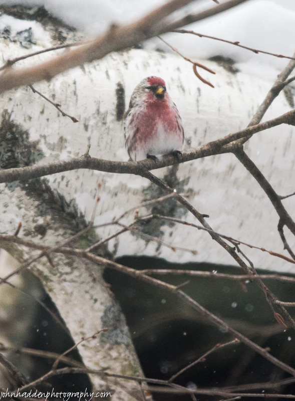
A particularly red redpole near our feeder
Morning Observation:
Brrrrrr! This morning in Huntington at 7:10AM it’s currently -18 degrees under clear skies. Winds are calm. Relative humidity is 81%, dewpoint -22, barometric pressure 30.26” and falling slowly. We have 21” of snow at the stake. Yesterday’s official high was 25 at 12:00AM on 2/23, but it was 6 by sunrise and the temperature slid all day to reach -20 by midnight last night. The overnight low was -20. Yup, chilly…
Forecast:
A weak ridge of high pressure will crest over the region today bringing partly sunny skies. Winds will become southerly which will allow temperatures to climb into the teens today—a welcome relief. Highs will be around 13 with south winds 10 to 15 mph. An area of low pressure will skirt to our north overnight bringing cloudy skies with a chance of snow showers mainly after midnight. Lows will be around 9 above with south winds 10 to 15 mph gusting up to 25 mph. Chance of snow is 50%.
Wednesday should be mostly cloudy with a chance of snow showers mainly in the morning. Highs will be around 19 with southwest winds 10 to 15 mph, becoming westerly in the afternoon. Chance of snow is 50%. The low will drag another cold front though Wednesday night bringing partly cloudy skies and more chilly air with lows -6 below to zero on northwest winds 10 to 15 mph.
Thursday’s looking partly sunny and cold with highs only around 5 above with northwest winds around 10 mph. Thursday night should be partly cloudy with lows around -10 below.
Almanac:
Last year on this date we had a high of 27 and a low of 16. We had 13.5″ of snow on the ground.
Burlington norms for this date are highs of 33 and lows of 15.
The record high was 55°F in 1930.
The record low was -18°F in 1914.
Sky Notes:
Sunrise: 6:38 AM EST
Sunset: 5:33 PM EST
Length of Visible Light: 11h 53m
Length of Day: 10h 55m
Tomorrow will be 2m58s longer.
The Moon is a waxing crescent, 5d 12h old with 37% illumination.
Moonrise: 9:57 AM EST
No Moon Set
About Today’s Photo:
This brilliantly colored redpole caught my eye the other day as he (I’m pretty sure it’s a “he”) was hanging around the feeders with a dozen or so of his compatriots. Maybe it’s just me, but it’s looking like the male birds are getting a bit brighter in anticipation of spring. One can hope!
Monday, February 23, 2015

A barred out lurks on one of our broken willows
Morning Observation:
This morning in Huntington at 7:00AM it’s currently 5 degrees under mostly cloudy skies. Winds are out of the southwest at 0-3 mph. Relative humidity is 74%, dewpoint -1, barometric pressure 30.26” and rising rapidly. We picked up a 0.30” dusting of snow overnight and have 22” at the stake. Yesterday’s high was a balmy 34, and the overnight low was 6.
There is a Wind Chill Advisory in effect for our region from 3:00PM this afternoon until 9:00AM Tuesday.
Forecast:
An Arctic cold front will move across the region today and will once again visit upon us more frigid air. We’ll see mostly cloudy skies with highs topping out at around 5 above this morning then falling to around -4 below this afternoon. Winds will be out of the northwest at 10 to 15 mph gusting up to 25 mph this afternoon. Wind chill values will be as low as 29 below. Tonight will be mostly cloudy and frigid with lows around -15 below with northwest winds 10 to 15 mph, becoming westerly after midnight.
The Arctic high will slide to our east Tuesday putting us in a southerly airflow and allowing for temperatures to rebound some. We’ll see mostly cloudy skies with highs around 16 and south winds 10 to 15 mph. Tuesday night should be cloudy with lows around 8 above and south winds 10 to 15 mph.
A surface trough will pass to our north on Wednesday bringing cloudy skies and a 40% chance of snow showers. Highs will be in the lower 20s with southwest winds 10 to 15 mph. More cold air will move in behind the trough on Wednesday night bringing partly cloudy with lows -5 below to -10 below zero.
Almanac:
Last year on this date we had a high of 45 and a low of 22. We had 13.75″ of snow on the ground.
Burlington norms for this date are highs of 33 and lows of 14.
The record high was 56°F in 1984.
The record low was -22°F in 1972.
Sky Notes:
Sunrise: 6:39 AM EST
Sunset: 5:31 PM EST
Length of Visible Light: 11h 50m
Length of Day: 10h 52m
Tomorrow will be 2m59s longer.
The Moon is a waxing crescent, 4d 12h old with 27% illumination.
Moonrise: 9:17 AM EST
Moonset: 11:30 PM EST
About Today’s Photo:
As I walked up our walkway yesterday afternoon coming back from a ski, I caught the movement of a larger critter flying out of the hemlock by the feeder. Sure enough, it was this barred owl lurking about looking for a meal. It flew up into the top of one of our now broken willow trees by the pond. Note the chickadee in the branch just below the owl. Chickadees like to know where the predators are, and will stay close and even harass them as a warning to other birds. Just another reason I love chickadees so much! The owl was nice enough to wait for me as I went inside and grabbed my camera.
Nikon D600, Sigma 120-400mm lens @ 400mm, ISO 800, f/5.6, 1/1250″ exposure
ou
Sunday, February 22, 2015

Deep snow, drifting, and Camel’s Hump through the trees.
Morning Observation:
This morning in Huntington at 8:30AM it’s currently 20 degrees and snizzling lightly under overcast skies. Winds are calm. Relative humidity is 94%, dewpoint 18, barometric pressure 30.17” and rising. We picked up 2.50” of new snow in the past 24hrs and have 22” at the stake. Yesterday’s high was 23 (at midnight) and the overnight low was 8.
Forecast:
A warm southerly airflow out ahead of the next blast of cold Arctic high pressure will help to push temperatures up into the low 30s today. We’ll see partly sunny skies with a 20% chance of snow showers this afternoon. Highs will be in the lower 30s with light and variable winds. The cold front will move through overnight with mostly cloudy skies and lows around -3 below with west winds 10 to 15 mph.
Monday should be partly sunny with highs only around 3 above with northwest winds 15 to 20 mph gusting up to 30 mph. Wind chill values could be as low as -27 below. Monday night will be partly cloudy and cold with lows around -12 below and west winds 10 to 15 mph.
Tuesday’s looking mostly cloudy and tad milder with highs around 15 and south winds 10 to 15 mph gusting up to 25 mph. Tuesday night should be mostly cloudy with a 30% chance of snow showers as a clipper system slides by to our north. Lows will be around 10 above.
Almanac:
Last year on this date we had a high of 44 and a low of 24. We picked up 0.50″ of rain and had 14.5″ at the stake.
Burlington norms for this date are highs of 32 and lows of 14.
The record high was 61°F in 1981.
The record low was -20°F in 1963.
Sky Notes:
Sunrise: 6:41 AM EST
Sunset: 5:30 PM EST
Length of Visible Light: 11h 48m
Length of Day: 10h 49m
Tomorrow will be 2m58s longer.
The Moon is a waxing crescent, 3d 13h old with 18% illumination.
Moonrise: 8:40 AM EST
Moonset: 10:21 PM EST
About Today’s Photo:
The snow is nearly 3 feet deep up in the hills near Camel’s Hump. This view from the east side of Crow Hill shows the Hump peeking through the trees on a bluebird afternoon.
Saturday, February 21, 2015

Last evening’s conjunction of Venus, Mars, and the crescent moon was spectacular!
Morning Observation:
This morning in Huntington at 8:10AM it’s currently a balmy 13 degrees under mostly cloudy skies. Winds are out of the south at 0-3 mph. Relative humidity is 45%, dewpoint -5, barometric pressure 30.39” and falling slowly. We picked up a dusting of snow in the past 24hrs and have 20” at the stake. Yesterday’s high was 13, and the overnight low was -10.
Forecast:
A weak upper level trough is pushing into the region this morning allowing temperatures to recover from their overnight lows and bringing cloudy skies with snow developing this afternoon. We should see snow accumulations of a dusting to 2″ today. Highs will be in the lower 20s with south winds 15 to 20 mph. Chance of snow is 90%. Snow will continue through the night with total snow accumulations of 3 to 5 inches for our region with higher totals south. Lows will be around 20 with south winds 10 to 15 mph. Chance of snow is 90%.
Sunday will be mostly cloudy and quite mild with a chance of lingering snow in the morning, then a slight chance of snow or even maybe freezing drizzle in the afternoon. Highs will be in the lower 30s with light and variable winds, becoming westerly around 10 mph in the afternoon. Chance of precipitation is 20%. The warmth will be short-lived however as another round of cold air will pull in Sunday night. Skies will be mostly cloudy with lows around -4 below and west winds 15 to 20 mph.
Monday should be partly sunny with highs around 2 above and northwest winds 15 to 20 mph. Monday night should be partly cloudy with lows around -15 below.
Almanac:
Last year on this date we had a high of 43 and a low of 31. We picked up 0.21″ of rain and had 17″ of snow at the stake.
Burlington norms for this date are highs of 32 and lows of 14.
The record high was 59°F in 1981.
The record low was -19°F in 1950.
Sky Notes:
Sunrise: 6:42 AM EST
Sunset: 5:29 PM EST
Length of Visible Light: 11h 45m
Length of Day: 10h 46m
Tomorrow will be 2m58s longer.
The Moon is a waxing crescent2d 13h old with 10% illumination.
Moonrise: 8:05 AM EST
Moonset: 9:09 PM EST
About Today’s Photo:
I posted this shot on my Photography Blog yesterday evening and thought I’d repeat it here—I just like it so much and it was such a lovely site to see!
Nikon D600, Sigma 120-400mm lens @ 140mm, ISO 800, f/4.8, 0.5″ exposure.
Friday, February 20, 2015

A clear view of the Hump from Shaker Mountain Road
Morning Observation:
This morning in Huntington at 7:10AM it’s currently -4 degrees and snizzling lightly under overcast skies. Winds are calm. Relative humidity is 83%, dewpoint -7, barometric pressure 29.93” and rising rapidly. We picked up 2.75” of new snow in the past 24hrs and have 20.50” at the stake. Yesterday’s high was 17, and the overnight low was -6.
Forecast:
Flurries and snow showers will come to an end today as high pressure builds into the region with clearing skies and chilly temperatures. After another cold night tonight temperatures will moderate
substantially out ahead of the next weather maker that will bring a light accumulating snowfall by later Saturday into Saturday night. We’ll see areas of blowing snow with cloudy skies and a 50% chance of snow showers this morning, then partly sunny skies with a slight chance of lingering snow showers this afternoon. It’ll be chilly with highs only around 7 above with northwest winds 10 to 15 mph gusting up to 25 mph. Tonight should be clear until midnight, then become partly cloudy. It’ll be cold with lows around -10 below with southwest winds around 10 mph until midnight, becoming light and variable.
A large long wave trough will move into the region Saturday from the midwest bringing mostly cloudy skies with snow likely in the afternoon. We should see snow accumulations of a dusting to 2 inches. Highs will bump up into the lower 20s with south winds around 10 mph. Chance of snow is 60%. Snow will continue into Saturday night with additional light snow accumulation. Lows will be in the lower 20s with south winds around 10 mph. Chance of snow is 90%.
Temperatures will bump even higher on Sunday with continued snow possibly mixing with drizzle and freezing drizzle. Expect little or no additional snow accumulation. Highs will be in the mid 30s with southwest winds 10 to 15 mph gusting up to 25 mph. Chance of precipitation is 70%. The warmth will be short-lived however as cold air returns Sunday night with lows around zero.
Almanac:
Last year on this date we had a high of 42 and a low of 16. We picked up 0.80″ of new snow and had 18″ at the stake.
Burlington norms for this date are highs of 32 and lows of 14.
The record high was 58°F in 1981.
The record low was -13°F in 1950.
Sky Notes:
Sunrise: 6:44 AM EST
Sunset: 5:27 PM EST
Length of Visible Light: 11h 42m
Length of Day: 10h 43m
Tomorrow will be 2m56s longer.
The Moon is a waxing crescent, 1d 12h old with 4% illumination.
Moonrise: 7:29 AM EST
Moonset: 7:55 PM EST
About Today’s Photo:
Camel’s Hump stands out boldly against blue skies in this view from Shaker Mountain Road.
Thursday, February 19, 2015

A close look at chunky frost crystals on sumac.
Morning Observation:
This morning in Huntington at 6:50AM it’s currently 11 degrees and snowing lightly under overcast skies. Winds are calm. Relative humidity is 90%, dewpoint 9, barometric pressure 29.62” and falling slowly. We picked up 0.05” of fluff overnight and have 19” on the ground. Yesterday’s high was a balmy 28, and the overnight low was 11.
Forecast:
Widespread light snow and snow showers will continue today into tonight as low pressure develops across the region and moves into the Canadian Maritimes by Friday morning. We’ll see light snow with snow accumulations of 1 to 3 inches. Highs will be around 15 with northwest winds 10 to 15 mph. Chance of snow is 70%. Snow will continue into tonight with additional snow accumulations of a dusting to 2 inches. Temperatures will drop behind the departing low with lows around -3 below with west winds 10 to 15 mph gusting up to 25 mph. Chance of snow is 70%.
Friday should start out cloudy with a chance of lingering snow showers in the morning, then become partly sunny with a slight chance of snow showers in the afternoon. Highs will be around 9 above with northwest winds 10 to 15 mph gusting up to 30 mph. Friday night should be mostly clear and cold with lows around -10 below with southwest winds around 10 mph.
Another low will approach from the Ohio River valley Saturday bringing mostly cloudy skies and a 30% chance of snow. Temperatures will rebound into the lower 20s during the day on south winds around 10 mph. Snow will develop Saturday night with light overnight snow accumulations of 2-5″. Lows will be 15 to 20. Chance of snow is 80%.
At this point, it looks like snow will continue into Sunday morning with temperatures rising dramatically into the low to mid 30s. We might see some “wintery mix” stuff happening later Sunday as the precipitation tapers off. Stay tuned!
Almanac:
Last year on this date we had a high of 36 and a low of 8. We picked up .75″ of new snow and had 8.25″ on the ground.
Burlington norms for this date are highs of 32 and lows of 13.
The record high was 62°F in 1981.
The record low was -23°F in 1944.
Sky Notes:
Sunrise: 6:46 AM EST
Sunset: 5:26 PM EST
Length of Visible Light: 11h 39m
Length of Day: 10h 40m
Tomorrow will be 2m56s longer.
The Moon is a barely waxing crescent, 12 hours old with 0% illumination.
Moonrise: 6:53 AM EST
Moonset: 6:40 PM EST
About Today’s Photo:
The sumac in our front field was studded with tiny crystals the other morning. I like the chunky structure of these crystals.
Nikon D600, Sigma 105mm macro, ISO 1000, f/20, 1/1000″ exposure.
Wednesday, February 18, 2015

A congregation of mourning doves in the hemlock by our feeder.
Morning Observation:
This morning in Huntington at 7:00AM it’s currently -7 degrees under partly cloudy skies. Winds are calm. Relative humidity is 85%, dewpoint -10, barometric pressure 29.95”. We have 19.25” of snow at the stake. Yesterday’s high was a balmy 18, and the overnight low was -9.
Forecast:
A low pressure trough currently out over the Great Lakes will move in our direction today. We’ll see partly sunny skies this morning giving way to cloudy skies with a 30% chance of snow showers this afternoon. Highs will be around 19 with light and variable winds. Tonight we should see some light snow with accumulations of 1 to 3 inches overnight. Lows will be around 8 above with light and variable winds. Chance of snow is 70%.
Snow will continue into Thursday with additional snow accumulations of 1 to 3 inches possible with highest amounts north and east. Highs will be around 12 with northwest winds 10 to 15 mph. Chance of snow is 70%. Snow will linger into Thursday night with additional light accumulations possible. More cold air will move in behind the departing low with overnight lows around -3 below with northwest winds 10 to 15 mph gusting up to 30 mph.
Friday’s looking partly sunny with a 50% chance of lingering snow showers. It’ll be chilly with highs only be around 7 above with northwest winds 10 to 15 mph gusting up to 30 mph. Friday night should be partly cloudy and cold with lows around -10 below.
At this point it looks like we may be seeing some strong, albeit temporary, warming over the weekend and particularly on Sunday. Stay tuned…
Almanac:
Last year on this date we had a high of 27 and a low of -6. We had 19″ of snow at the stake.
Burlington norms for this date are highs of 31 and lows of 13.
The record high was 58°F in 1981.
The record low was -25°F in 1979.
Sky Notes:
Sunrise: 6:47 AM EST
Sunset: 5:24 PM EST
Length of Visible Light: 11h 36m
Length of Day: 10h 37m
Tomorrow will be 2m55s longer.
The Moon is new (or at least about an hour away from being new…) 28d 23h old with 0% illumination.
Moonrise: 6:15 AM EST
Moonset: 5:23 PM EST
About Today’s Photo:
We had us a congregation of mourning doves camped out in the hemlock and bent birch by the feeders yesterday. There were several more that I couldn’t get into one frame. They seemed quite content to soak in the sunshine for a while.
Tuesday, February 17, 2015

A chickadee pauses briefly before heading to the feeder
Morning Observation:
This morning in Huntington at 6:55AM it’s currently -15 degrees under partly cloudy skies. Winds are calm. Relative humidity is 83%, dewpoint -18, barometric pressure 30.05” and falling slowly. We have 19.75” of snow at the stake. Yesterday’s high was 11, and the overnight low was -17.
Forecast:
High pressure will move to our east today. We’ll see partly sunny skies this morning, then mostly cloudy skies this afternoon. Highs will be around 14 with light and variable winds. Tonight should be cloudy and not as cold with lows around -1 below with light and variable winds.
An upper level trough will swing through the region Wednesday bringing cloudy skis and a 20% chance of snow showers in the afternoon. Highs will be around 18 with light and variable winds. Wednesday night light snow is likely with light snow accumulations possible. Lows will be around 3 above with light and variable winds. Chance of snow is 70%.
Thursday should be cloudy with a 50% chance of lingering snow showers. Yet another blast of Arctic cold will head our way with highs only around 8 above during the day with northwest winds 10 to 15 mph gusting up to 25 mph. Thursday Night should be cloudy and cold with lows -5 below to -10 below zero.
Almanac:
Last year on this date we had a high of 20 and a low of -12. We had 19.75″ on the ground (sounds familiar…)
Burlington norms for this date are highs of 31 and lows of 13.
The record high was 53°F 1981.
The record low was -21°F in 1963.
Sky Notes:
Sunrise: 6:49 AM EST
Sunset: 5:23 PM EST
Length of Visible Light: 11h 33m
Length of Day: 10h 34m
Tomorrow will be 2m53s longer.
The Moon is a waning crescent, 27d 23h old with 3% illumination.
Moonrise: 5:32 AM EST
Moonset: 4:07 PM EST
About Today’s Photo:
Chickadees are hands-down my favorite birds. Their affable, gregarious nature seems to invite observation and interaction. On cold mornings, they’re the first to hit the feeders to keep their little bodies going in the sub-zero chill.
Monday, February 16, 2015

Fine frost feathers cling to an apple tree
Morning Observation:
This morning in Huntington at 7:25AM it’s currently -20 degrees under clear skies. Winds are calm. Relative humidity is 81%, dewpoint -24, barometric pressure 30.15” and rising slowly. We have 21” at the stake. Yesterday’s high was 12, and the overnight low was -20.
Forecast:
Another very cold day is expected today with increasing amounts of sunshine and decreasing wind. Surface high pressure will be directly overhead tonight bringing clear skies, light
winds, and very cold temperatures. We’ll see mostly sunny skies today with highs only around 3 above with northwest winds 15 to 20 mph and gusting up to 35 mph this morning. Wind chill values could be as low as -39 below. Tonight should be mostly clear until midnight, then become partly cloudy. It’ll be cold with lows -12 below to -20 below zero with northwest winds around 10 mph until midnight, becoming light and variable.
A weak short wave trough will skirt to our south on Tuesday bringing mostly cloudy skies with a 20% chance of light snow in the afternoon. Highs will be around 12 with light and variable winds. Tuesday night should be cloudy and not as cold with lows -7 below to 1 above zero with light and variable winds.
A low pressure system will develop out over the Great Lakes and move our way Wednesday bringing snow with light accumulations possible. Highs will be around 18 with light and variable winds. Chance of snow is 60%. Wednesday night should be cloudy with a 50% chance of light snow. Lows will be around zero.
Almanac:
Last year on this date we had a high of 23 and a low of -3. We picked up 1.25″ of new snow and had 20.5″ at the stake.
Burlington norms for this date are highs of 31 (yah, right…) and lows of 13 (uh-huh…)
The record high was 49°F in 1921.
The record low was -26°F in 1943.
Sky Notes:
Sunrise: 6:50 AM EST
Sunset: 5:22 PM EST
Length of Visible Light: 11h 31m
Length of Day: 10h 31m
Tomorrow will be 2m54s longer.
The Moon is a waning crescent, 26d 23h old with 9% illumination.
Moonrise: 4:45 AM EST
Moonset: 2:54 PM EST
About Today’s Photo:
Here’s an alternate view of the frost feathers I posted in my last post on Friday. These are clinging to the bark of the apple tree itself above the critter hole.
Friday, February 13, 2015

Fine frost feathers on an apple stem
Morning Observation:
This morning in Huntington at 7:05AM it’s currently -8 degrees under party cloudy skies. Winds are calm. Relative humidity is 79%, dewpoint -12, barometric pressure 30.07” and rising rapidly. We picked up 2.2” of new snow and have 20.5” at the stake. Yesterday’s high was 28, and the overnight low was -8.
There is a Wind Chill Advisory in effect for our region until noon today.
Forecast:
Frigid high pressure is currently building into the region and will deliver a chilly day. We’ll see mostly sunny skies with highs only around -3 below with northwest winds 10 to 15 mph gusting up to 30 mph. Wind chill values could be as low as -36 below. Tonight should be partly cloudy until midnight, then become cloudy. It’ll be cold with lows around -16 below with temperatures rising to around -6 below after midnight out ahead of the next weather maker. Winds will be out of the west at around 10 mph until midnight, becoming light and variable.
A clipper-like low will approach from the Great Lakes on Saturday bringing occasional snow showers with snow accumulations of a dusting to 2 inches. Highs will be around 14 with southeast winds around 10 mph. Chance of snow is 80%. Snow will continue into Saturday night with additional light snow accumulations. It will be a tad warmer with lows around -3 below with northeast winds 15 to 20 mph with gusting up to 30 mph. Chance of snow is 80%.
The low will pass to our south by Sunday and be off the Long Island coast setting up the delivery of more snow during the day. Expect additional light snow accumulations of 2-4 inches in the Champlain Valley with higher amounts east. It’ll be blustery with highs around 1 above with northwest winds 15 to 25 mph gusting up to 45 mph. Chance of snow is 70%. Sunday night should be partly cloudy and blustery. It’ll be colder with lows -10 below to -15 below zero.
Almanac:
Last year on this date we had a high of 29 and a low of 6. We had 10.5″ of snow on the ground.
Burlington norms for this date are highs of 30 and lows of 12.
The record high was 53°F in 1937.
The record low was -25°F in 1967.
Sky Notes:
Sunrise: 6:54 AM EST
Sunset: 5:18 PM EST
Length of Visible Light: 11h 23m
Length of Day: 10h 23m
Tomorrow will be 2m50s longer.
Then Moon is a waning crescent, 23d 23h old with 36% illumination.
Moonrise: 1:58 AM EST
Moonset: 11:53 AM EST
About Today’s Photo:
I came across these fine, delicate frost feathers growing from a sucker stem next to one of the apple trees in our back yard. There was a hole just below the stem and next to the tree were I’ll wager some critter has taken up winter residence allowing its warm breath to create just enough moisture for the crystals to form.
Thursday, February 12, 2015

A tiny vine, dried aster stem and sumac all bejeweled with morning frost
Morning Observation:
This morning in Huntington at 7:35AM it’s currently 22 degrees under overcast skies. A few random snowflakes are falling. Winds are calm. Relative humidity is 90%, dewpoint 19, barometric pressure 29.73” and falling slowly. We picked up a 0.75” dusting of fluff overnight and have 19” at the stake. Yesterday’s high was 24, and the overnight low was 15.
There is a Wind Chill Advisory in effect from midnight tonight until noon on Friday.
Forecast:
A weak clipper system will produce a light snow event across the region today with snow accumulations of 1 to 3 inches with a few isolated higher amounts across the mountains. A very cold airmass will follow this system for tonight into Friday. We’ll see light snow today with accumulations of 1 to 3 inches during the day. Highs will be in the mid 20s with temperature falling to around 15 this afternoon. Winds will be light and variable, becoming northwesterly 10 to 15 mph this afternoon. Chance of snow is 80%. Tonight should be cloudy with snow showers likely mainly until midnight. Expect total snow accumulations of 3 to 5 inches with higher amount in northern mountain locations. It’ll be much colder with lows around -8 below and northwest winds 10 to 15 mph. Chance of snow is 70%. Wind chill values as low as 28 below.
Friday should be mostly cloudy in the morning, then become partly sunny. I’ll be much colder with highs only around -3 below with northwest winds 10 to 15 mph gusting up to 25 mph in the afternoon. Wind chill values could be as low as -30 below. Friday night should be mostly cloudy with lows around -14 below with southwest winds around 10 mph.
A shortwave trough will slide through Saturday bringing showers with little or no snow accumulation. Highs will be around 10 above with southeast winds around 10 mph. Chance of snow is 70%. Snow will continue into Saturday Night with light snow accumulations possible. It’ll remain cold with lows around -5 below. Chance of snow is 70%.
Almanac:
Last year on this date we had a high of 26 and a low of -13. We had 11″ at the stake.
Burlington norms for this date are highs of 30 and lows of 12 (it would be kind of nice to see those kinds of temps…)
The record high was 56°F in 1999 (we had a high of 61!)
The record low was -30°F in 1979.
Sky Notes:
Sunrise: 6:56 AM EST
Sunset: 5:16 PM EST
Length of Visible Light: 11h 20m
Length of Day: 10h 20m
Tomorrow will be 2m49s longer.
The Moon is a waning crescent, 22d 23h old with 46% illumination.
Moonrise: 12:58 AM EST
Moonset: 11:08 AM EST
About Today’s Photo:
Yesterday morning’s chilly air decked out this trio of a sumac stem, dried aster, and tiny vine with fine crystals.
Wednesday, February 11, 2015

Bent but not broken…
Morning Observation:
This morning in Huntington at 7:00AM it’s currently -7 degrees under mostly clear skies. Winds are calm. Relative humidity is 86%, dewpoint -10, barometric pressure 30.22”. We picked up a dusting of new snow in the past 24hrs and have 19” at the stake. Yesterday’s high was 19, and the overnight low was -7.
Forecast:
High pressure will bring dry weather today with just some increasing high clouds from west to east across the region. An Alberta clipper approaching from the Great Lakes will bring widespread light snow to the region Thursday…with lingering snow showers in the mountains through Thursday night. We’ll see partly sunny skies today with highs in the lower 20s and light and variable winds. Tonight will be cloudy with light snow likely after midnight. Expect light snow accumulations of a dusting to 1 inch overnight. Lows will be around 12 with light and variable winds. Chance of snow is 70%.
Thursday we’ll see light snow throughout the day with snow accumulations of a dusting to 2 inches. Highs will be in the lower 20s with light and variable winds, becoming northwesterly around 10 mph in the afternoon. Chance of snow is 80%. Snow will continue into Thursday night with additional light snow accumulation possible. Expect a total of 2-4 inches before it wraps up. Lows will around 1 above with northwest winds 10 to 15 mph. Chance of snow is 70%.
Cold air will arrive behind the departing clipper on Friday. We’ll see mostly cloudy skies with a 40% chance of lingering snow showers. Highs will be around 6 above with northwest winds 10 to 15 mph. Friday night should be partly cloudy and colder with lows around -10 below.
Almanac:
Last year on this date we had a high of 17 and a low of -8. We picked up 1″ of new snow and had 12″ on the ground.
Burlington norms for this date are highs of 30 and lows of 12.
The record high was 58°F in 1981.
The record low was -27°F in 1979.
Sky Notes:
Sunrise: 6:57 AM EST
Sunset: 5:15 PM EST
Length of Visible Light: 11h 17m
Length of Day: 10h 17m
Tomorrow will be 2m47s longer.
The Moon is in its last quarter, 21d 23h old with 57% illumination.
No Moon Rise
Moonset: 10:29 AM EST
About Today’s Photo:
Dried aster stems above the snow.
pou
Tuesday, February 10, 2015
Dried milkweed stems in the front field
Morning Observation:
This morning in Huntington at 6:55AM it’s currently 16 degrees under overcast skies. Winds are calm. Relative humidity is 91%, dewpoint 14, barometric pressure 30.18. We picked up a 0.20” dusting of snow in the past 24hrs and have 19.75” on the ground. Yesterday’s high was 23, and the overnight low was 16.
Forecast:
High pressure building eastward from the Great Lakes and northern Ontario will provide dry and seasonably cold weather weather across the region today through Wednesday. We’ll see cloudy this morning giving way to partly sunny skies this afternoon. Highs will be in the lower 20s with light and variable winds, becoming northerly around 10 mph this afternoon. Tonight should be mostly clear and chilly with lows -6 below to zero with north winds around 10 mph until midnight, becoming light and variable.
Wednesday should be partly sunny in the morning, then become mostly cloudy as a clipper system approaches. Highs will be around 19 with light and variable winds. Wednesday night should be cloudy with a 50% chance of snow. Lows will be around 11 with south winds around 10 mph.
The clipper will move through Thursday bringing snow with light accumulations possible. Highs will be in the mid 20s with south winds around 10 mph. Chance of snow is 90%. Snow will continue into Thursday night with additional light snow accumulations possible. Lows will be around zero. Chance of snow 70%.
Another shot of Arctic cold is set to settle in for the upcoming weekend.
Almanac:
Last year on this date we had a high of 20 and a low of 1. We picked up 3″ of new snow and had 12″ on the ground.
Burlington norms for this date are highs of 29 and lows of 11.
The record high was 46°F in 1925.
The record low was -26°F in 1948.
Sky Notes:
Sunrise: 6:59 AM EST
Sunset: 5:13 PM EST
Length of Visible Light: 11h 15m
Length of Day: 10h 14m
Tomorrow will be 2m47s longer.
The Moon is waning gibbous, 20d 22h old with 66% illumination.
Moonrise: 11:57 PM EST
Moonset: 9:55 AM EST
About Today’s Photo:
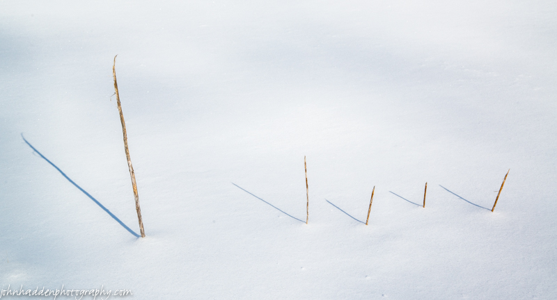
Four dried milkweed stems tell the time of day in the front field.
Monday, February 9, 2015

A sculpture casts shadows out next to Fargo Brook
Morning Observation:
This morning in Huntington at 7:00AM it’s currently 12 degrees under overcast skies. Winds are calm. Relative humidity is 91%, dewpoint 10, barometric pressure 30.14”. We picked up 3” of snow by 4:00PM yesterday afternoon and another 0.5” of snow overnight along with a light crusting from freezing drizzle. We have 20.75” at the stake. Yesterday’s high was 12, and the overnight low was 8.
The Winter Weather Warning for our region has been cancelled.
Forecast:
Weak low pressure over the Ohio River valley this morning will drift southeastward to the Carolina coast by late afternoon with the long duration light snow event coming to an end this evening. We’ll see cloudy skies with a chance of light snow and patchy freezing drizzle this morning, then light snow likely with patchy freezing drizzle this afternoon. We may see some accumulation in the dusting to 2″ range, with amounts increasing south were Winter Weather advisories are still in place. Highs will be around 17 with light and variable winds. Chance of precipitation is 70%. Tonight should be mostly cloudy with a 20% chance of light snow and patchy freezing drizzle. Lows will be around 8 above with light and variable winds.
High pressure will build in Tuesday bringing partly sunny skies with highs around 17 and light and variable winds. Tuesday night should be partly cloudy and colder with lows around -5 below wit light and variable winds.
Wednesday’s looking partly sunny with highs around 16 and light and variable winds. A clipper system will approach the region Wednesday night bringing cloudy skies with a 50% chance of snow. Lows will be around 10 above.
Almanac:
Last year on this date we had a high of 24 and a low of 7. We had 9″ of snow on the ground.
Burlington norms for this date are highs of 29 (up another degree!) and lows of 11.
The record high was 53°F in 1925.
The record low was -28°F in 1934.
Sky Notes:
Sunrise: 7:00 AM EST
Sunset: 5:12 PM EST
Length of Visible Light: 11h 12m
Length of Day: 10h 11m
Tomorrow will be 2m45s longer.
The Moon is waning gibbous, 19d 23h old with 75% illumination.
Moonrise: 10:57 PM EST
Moonset: 9:25 AM EST
About Today’s Photo:
This cobbled together sculpture out in our back yard next to Fargo Brook casts interesting shadows…
Thursday, February 5, 2015

A fen seedhead peeks up from under the snow
Morning Observation:
This morning in Huntington at 7:25AM it’s currently 12 degrees and snowing lightly under overcast skies. Winds are calm. Relative humidity is 87%, dewpoint 9, barometric pressure 30.05” and rising rapidly. We picked up 4.75” of fluffy snow overnight and have 21” at the stake. Yesterday’s high was 30, and the overnight low was 12.
Forecast:
An Arctic cold front will push southeast of the region this morning with snow showers coming to an end followed by clearing skies. We’ll see cloudy skies with snow showers likely this morning, then partly sunny skies this afternoon. Highs will be around 13 with northwest winds 10 to 15 mph gusting up to 25 mph. Chance of snow is 50%. Tonight should be mostly clear until midnight, then become partly cloudy. It will be much colder with lows around -11 below with northwest winds 10 to 15 mph becoming westerly after midnight.
Friday Mostly cloudy with a 40% chance of snow showers as a weak shortwave disturbance slides to our north. Highs will be around 17 with southwest winds around 10 mph. Friday night should be cloudy with a 40% chance of snow showers. Lows will be around 8 above with west winds around 10 mph.
Saturday’s looking cloudy with a 40% chance of snow showers as another shortwave disturbance slides by. Highs will be around 17 with light and variable winds. Saturday night should be mostly cloudy with a 50% chance of snow showers. Lows will be around zero.
Almanac:
Last year on this date we had a high of 24 and a low of 10. We picked up 7.5″ of new snow through the day and had 12″ at the stake by the next morning.
Burlington norms for this date are highs of 28 and lows of 11.
The record high was 51°F in 1991.
The record low was -27°F in 1908.
Sky Notes:
Sunrise: 7:05 AM EST
Sunset: 5:06 PM EST
Length of Visible Light: 11h 02m
Length of Day: 10h 01m
Tomorrow will be 2m39s longer.
The Moon is waning gibbous, 15d 23h old with 98%, illumination.
Moonrise: 7:04 PM EST
Moonset: 7:35 AM EST
About Today’s Photo:
This fern seedhead seems to be waiting patiently for the snow to melt so it can do its job…
Wednesday, February 4, 2015

Camel’s Hump looms behind trees from the Lion’s Ridge Trail at Camel’s Hump Nordic
Morning Observation:
This morning in Huntington at 7:05AM it’s currently 18 degrees and snowing lightly under overcast skies. Winds are out of the southwest at 0-4 mph. Relative humidity is 86%, dewpoint 14, barometric pressure 30.16” and falling slowly. We’ve picked up just a dusting of new snow so far and have 17.75” at the stake. Yesterday’s high was 19, and the overnight low was 14.
Forecast:
A weak clipper system is moving across the region this morning bringing cloudy skies and snow showers mainly this morning. We’ll see snow accumulations of a dusting to 2 inches out of it. It will be seasonably milder with highs will be in the upper 20s with south winds 10 to 15 mph. Chance of snow is 70%. An arctic cold front will move across the region tonight bringing occasional snow showers with total snow accumulations of 2 to 4 inches. Lows will be around 6 above with southwest winds 10 to 15 mph gusting up to 25 mph and becoming northwesterly after midnight. Chance of snow is 90%.
Thursday should start out mostly cloudy with a 50% chance of snow showers in the morning, then become partly sunny with a slight chance of snow showers in the afternoon as yet another round of frigid arctic air pulls in. Highs will be around 10 above with northwest winds 10 to 15 mph gusting up to 25 mph. Thursday night should be partly cloudy and much colder with lows around -12 below with northwest winds 10 to 15 mph gusting up to 25 mph.
Friday’s looking partly sunny with highs around 14 with southwest winds around 10 mph. Friday night should be mostly cloudy with lows around 5 above.
Almanac:
Last year on this date we had a high of 27 and a low of 12. We had 5″ of snow on the ground.
Burlington norms for this date are highs of 28 and lows of 11 (up a degree, not that we’ve been seeing anything like normal temps so far this season…)
The record high was 52°F in 1991.
The record low was -26°F in 1963.
Sky Notes:
Sunrise: 7:06 AM EST
Sunset: 5:05 PM EST
Length of Visible Light: 10h 59m
Length of Day: 9h 58m
Tomorrow will be 2m37s longer.
The Moon is (technically) waning gibbous, 14d 23h old with 100% illumination.
Moonrise: 6:07 PM EST
Moonset: 7:05 AM EST
About Today’s Photo:
There’s a particular spot along the Lion’s Ridge Trail at Camel’s Hump Nordic were, weather permitting, you can get a sweet view of the northwestern flank of Camel’s Hump. Such was the view the other day under clear blue skies.
Tuesday, February 3, 2015
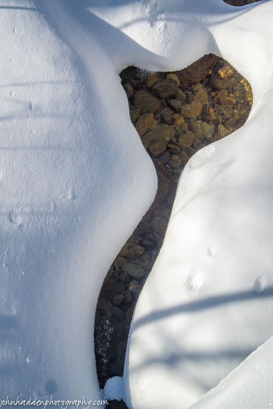
Fresh snow and open water in Fargo Brook
Morning Observation:
This morning in Huntington at 6:35AM it’s currently a brisk -17 degrees under clear skies. Winds are calm. Relative humidity is 82%, dewpoint -21, barometric pressure 30.13” and rising. We picked up a storm total of 5.25” of light snow and have 18.5” at the stake. Yesterday’s high was 6, and the overnight low was -17.
Forecast:
Weak high pressure is currently building into the region this morning and will deliver a quiet day. We’ll see partly sunny skies this morning, then mostly cloudy skies in the afternoon as a clipper systems moves through from the Great Lakes. Temperatures will recover some to around 14 with light and variable winds, becoming southwesterly around 10 mph this afternoon. Tonight should be cloudy with 50% chance of snow showers mainly after midnight. Lows will be around 10 above with south winds 10 to 15 mph.
Snow will continue into Wednesday with snow accumulations of a dusting to 2 inches possible. Highs will warm into the upper 20s on south winds 10 to 15 mph out ahead of another weak low heading our way Wednesday night into Thursday. Wednesday night snow showers are likely. Additional light snow accumulation possible. Lows will be around 7 above with northwest winds 10 to 15 mph. Chance of snow is 60%.
Thursday should be mostly cloudy with a 50% chance of lingering snow showers. Highs will be around 11 with north winds 10 to 15 mph gusting up to 25 mph. Cold high pressure will build Thursday night bringing partly cloudy skies and with lows around -10 below.
Almanac:
Last year on this date we had a high of 28 and a low of 12. We had 5″ of snow on the ground.
Burlington norms for this date are highs of 28 and lows of 10.
The record high was 49°F in 1991.
The record low was -25°F in 1971.
Sky Notes:
Sunrise: 7:08 AM EST
Sunset: 5:04 PM EST
Length of Visible Light: 10h 57m
Length of Day: 9h 56m
Tomorrow will be 2m36s longer.
The Moon is the full “Snow” Moon (Northeast Native American, Neo Pagan Wiccan)
13d 22h old with 100% illumination.
Moonrise: 5:09 PM EST
Moonset: 6:33 AM EST
Other names for this month’s full moon include: “Trapper” (Colonial American), “Wold” (English), “Ice” (Celtic), and “Storm” (Medieval Wiccan).
About Today’s Photo:
Fresh snow and open water create fanciful shapes in Fargo Brook
Monday, February 2, 2015

An oak leaf in the snow
Happy Groundhog Day!
Morning Observation:
This morning in Huntington at 6:45AM it’s currently 2 degrees and snowing lightly under overcast skies. Winds are calm. Relative humidity is 87%, dewpoint -1, barometric pressure 29.90” and falling rapidly. We picked up 0.75” of new snow overnight and have 16” at the stake. Yesterday’s high was 12, and the overnight low was -12.
A Winter Storm Warning remains in effect for our region until 1:00AM Tuesday morning.
Forecast:
A Surface low is moving into southwestern Pennsylvania this morning and is projected to move off the
southern New England/eastern Long Island coast by this afternoon intensifying as it does. This will bring widespread snow to our region throughout the day. Snow may be heavy at times this morning. Highs will only be around 6 above with northeast winds around 10 mph, becoming northerly this afternoon. Chance of snow is near 100%. Tonight should be cloudy with snow likely until midnight, then a chance of snow showers after midnight. It’ll be cold with lows around -10 below and northwest winds 10 to 15 mph. Chance of snow is 70%. The NWS is predicting total snow accumulations in our area of 4 to 8 inches with higher amounts south. The Eye-On-The-Sky guys are showing us in the 9-12″ band (see chart below).

Tuesday should start out partly sunny and chilly with highs around 11 and west winds around 10 mph. Tuesday night should be mostly cloudy with a 30% chance of snow showers out ahead of an approaching clipper system. Lows will be around 6 above with south winds around 10 mph.
Wednesday’s looking cloudy with a 50% chance of snow showers. It will be more seasonable with highs in the mid 20s and south winds around 10 mph. Wednesday night snow showers are likely as the clipper moves through. Expect light snow accumulation. Lows will be 5 to 10 above. Chance of snow is 60%.
Almanac:
Last year on this date we had a high of 39 and a low of 27. We picked up 0.75″ of new snow and had 5.5″ at the stake.
Burlington norms for this date are highs of 28 and lows of 10.
The record high was 47°F in 1981.
The record low was -25°F in 1962.
Sky Notes:
Sunrise: 7:09 AM EST
Sunset: 5:02 PM EST
Length of Visible Light: 10h 55m
Length of Day: 9h 53m
Tomorrow will be 2m34s longer.
The Moon is waxing gibbous, 12d 22h old with 98% illumination.
Moonrise: 4:12 PM EST
Moonset: 5:57 AM EST
About Today’s Photo:
The red oak in our front yard still has leaves to contribute to the winter still life…
Sunday, February 1, 2015

A cluster of dried stems cast shadows in fresh snow
Rabbit-rabbit!
Morning Observation:
This morning in Huntington at 8:35AM, it’s currently 6 degrees and snizzling lightly under overcast skies. Winds are calm. Relative humidity is 85%, dewpoint 3, barometric pressure 30.27” and rising rapidly. We picked up 0.7” of fluff overnight and have 16” at the stake. Yesterday’s high was 9 and the overnight low was -11.
There is a Winter Weather Advisory in effect for our region from 1:00AM Monday until 1:00AM Tuesday.
Forecast:
We’ll have a quiet albeit chilly day today before the next weather maker arrives for Monday. We’ll see mostly cloudy skies with a slight chance of flurries this morning, then partly sunny skies this afternoon. Highs will be around 8 above with northwest winds around 10 mph. Tonight should be partly cloudy until midnight, then become cloudy with a chance of snow after midnight. It’ll be cold with lows around -11 below and light and variable winds. Chance of snow is 50%.
A deepening low pressure system will move out of the Ohio River Valley early Monday bringing widespread snow to our region. Total snow accumulation of 4 to 6 inches with heavier amounts south. Highs will be around 4 above with light and variable winds, becoming northerly around 10 mph in the afternoon. Chance of snow is 90%. Monday night should be mostly cloudy with a 50% chance of snow showers as the low moves into the Gulf of Maine. It’ll be cold with lows around -10 below and northwest winds around 10 mph.
Tuesday should be partly sunny with highs around 10 above and west winds around 10 mph. Tuesday night should be mostly cloudy with lows zero to 5 above zero.
Almanac:
Last year on this date we had a high of 39 and a low of 11. We had 5″ of snow at the stake.
Burlington norms for this date are highs of 28 and lows of 10.
The record high was 50°F in 1988.
The record low was -28°F in 1920.
Sky Notes:
Sunrise: 7:10 AM EST
Sunset: 5:01 PM EST
Length of Visible Light: 10h 52m
Length of Day: 9h 50m
Tomorrow will be 2m32s longer.
The Moon waxing gibbous, 12 days old with 95% illumination.
Moonrise: 3:15 PM EST
Moonset: 5:17 AM EST
About Today’s Photo:
Open fields, fresh snow and ample sunlight lend themselves to looking at the world in simplified terms of positive and negative space. These dried stems in the front field cast bold shadows across the fresh snow.
Nikon D600, Nikon 24-120mm lens @ 62mm, circular polarizing filter, ISO 400, f/13, 1/200″ exposure.
