Thursday, April 30, 2015
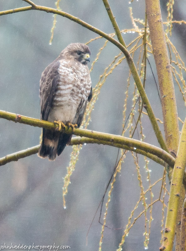
A hawk perches in our pond-side willow in the rain.
Morning Observation:
This morning in Huntington at 6:55AM it’s currently 36 degrees under mostly cloudy skies. Winds are calm. Relative humidity is 98%, dewpoint 36, barometric pressure 29.891” and rising. Yesterday’s high was 61, and the overnight low was 32.
Forecast:
Variable clouds, dry weather and seasonably mild temperatures will be the rule across the region through Saturday as weak high pressure remains in place across the region. We’ll see partly sunny skies today with highs in the lower 60s and light and variable winds, becoming northerly around 10 mph in the afternoon. Tonight should be mostly cloudy with a slight chance of showers after midnight. Lows will be in the lower 40s with northeast winds around 10 mph until midnight, becoming light and variable. Chance of rain is 20%.
Friday should be mostly cloudy with highs in the lower 60s and light and variable winds. Friday night should be partly cloudy with lows around 40 and light and variable winds.
A warm southerly airflow pulls in for Saturday brining partly cloudy skies with highs in the upper 60s to near 70. Saturday night should be partly cloudy with lows in the mid 40s. At this point it’s looking like Sunday will be near 70 as well!
Almanac:
Last year on this date we had a high of 46 and a low of 39. We picked up 0.08″ of rain.
Burlington norms for this date are highs of 62 and lows of 40.
The record high was 84°F in 2004 (we had a high of 82).
The record low was 27°F in 1967.
Sky Notes:
Sunrise: 5:44 AM EDT
Sunset: 7:54 PM EDT
Length of Visible Light: 15h 13m
Length of Day: 14h 09m
Tomorrow will be 2m39s longer.
The Moon is waxing gibbous, 11d 16h old with 88% illumination.
Moonrise: 4:37 PM EDT
Moonset: 4:07 AM EDT
About Today’s Photo:
This hawk was hanging out in the willow next to our pond the other day in the rain. I’m not quite sure what kind it is, perhaps a juvenile red tailed? Anyone care to identify it for me?
Wednesday, April 29, 2015

False hellebore sprouting in a wetland along Taft Road.
Morning Observation:
This morning in Huntington at 6:55AM it’s currently 33 degrees under partly cloudy skies. Winds are calm. Relative humidity is 98%, dewpoint 33, barometric pressure 29.72” and rising. Yesterday’s high was 56, and the overnight low was 32.
Forecast:
Weak surface high pressure will dominate our weather for the next couple of day. We’ll see partly sunny skies this morning, then mostly cloudy skies later in the day. Highs will be in the upper 50s to near 60 with north winds 10 to 15 mph. Tonight should be partly cloudy with lows around 40 and north winds around 10 mph until midnight, becoming light and variable.
Thursday should be partly sunny with highs in the lower 60s and light and variable winds, becoming northerly around 10 mph in the afternoon. Thursday night should be mostly cloudy with lows in the lower 40s and east winds around 10 mph.
Friday’s looking mostly cloudy with highs in the lower 60s and light and variable winds. Friday night should be partly cloudy with lows in the lower 40s.
Almanac:
Last year on this date we had a high of 58 and low of 41.
Burlington norms for this date are highs of 61 and lows of 40.
The record high was 85°F in 1986.
The record low was 24°F in 1934.
Sky Notes:
Sunrise: 5:46 AM EDT
Sunset: 7:53 PM EDT
Length of Visible Light: 15h 10m
Length of Day: 14h 07m
Tomorrow will be 2m42s longer.
The Moon is waxing gibbous, 10d 16h old with 81% illumination.
Moonrise: 3:39 PM EDT
Moonset: 3:39 AM EDT
About Today’s Photo:
False hellebore (Veratrum viride) is an early riser this time of year, popping up in soggy wetlands and along streams in the early spring. This batch was growing in a wide wetland along Taft Road.
Tuesday, April 28, 2015

Hepatica blossoms begin to open in the woods behind the house
Morning Observation:
This morning in Huntington at 6:00AM it’s currently 32 degrees under mostly cloudy skies. Winds are calm. Relative humidity is 97%, dewpoint 32, barometric pressure 29.84” and rising. We picked up 0.25” of rain in the past 24hrs. Yesterday’s high was 46, and the overnight low was 32.
Forecast:
The pesky low pressure system which has brought cool and cloudy weather to the region over the past week will finally begin to lose its influence over us today with mainly dry weather and warmer temperatures expected. We’ll see mostly cloudy skies with highs in the mid 50s and north winds 10 to 15 mph gusting up to 30 mph. Tonight should be mostly cloudy until midnight, then clearing. Lows will be in the upper 30s with north winds 10 to 15 mph.
Wednesday should be partly sunny in the morning then become mostly cloudy. Highs will be in the upper 50s with northwest winds around 10 mph. Wednesday night should be mostly cloudy with lows in the lower 40s and northeast winds around 10 mph.
Thursday’s looking partly sunny with highs in the lower 60s and northeast winds around 10 mph. Thursday night should be mostly cloudy with lows in the lower 40s.
Almanac:
Last year on this date we had a high of 53 and a low of 32. We picked up 0.09″ of rain.
Burlington norms for this date are highs of 61 and lows of 40.
The record high was 90°F in 1990.
The record low was 24°F in 1947.
Sky Notes:
Sunrise: 5:47 AM EDT
Sunset: 7:52 PM EDT
Length of Visible Light: 15h 07m
Length of Day: 14h 04m
Tomorrow will be 2m43s longer.
The Moon is waxing gibbous, 9d 15h old with 72% illumination.
Moonrise: 2:41 PM EDT
Moonset: 3:11 AM EDT
About Today’s Photo:
There are certain places in the area where I can be assured that some of the earliest spring ephemeral wildflowers will make a showing. I was not disappointed when I walked to where the hepatica bloom. This little pair was making a go of it on a chilly morning just a couple of days ago.
Nikon D600, Sigma 105mm lens, ISO 1600, f/18, 1/125″ exposure.
Monday, April 27, 2015

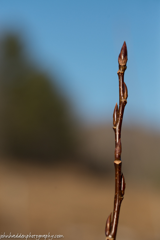
Red maple buds bursting
Morning Observation:
This morning in Huntington at 6:20AM it’s currently 40 degrees and raining lightly under overcast skies. Winds are out of the south at 0-4 mph. Relative humidity is 96%, dewpoint 39, barometric pressure 29.67” and rising slowly. We picked up 0.13” of rain overnight. Yesterday’s high was 50, and the overnight low was 40.
Forecast:
The “Omega Block” that has set up to our north and east persists to deliver cool, moist air to our region (for a good discussion of the Omega block, check out the Eye On The Sky’s Facebook page.) We’ll see rain showers today. Highs will only be in the upper 40s with north winds 10 to 15 mph. Chance of rain is 70%. Tonight should be cloudy with a 50% chance of showers, mainly until midnight. Lows will be around 40 with north winds 10 to 15 mph gusting up to 30 mph.
Tuesday should be mostly cloudy in the morning, then becoming partly sunny. Highs will be in the mid 50s with north winds 10 to 15 mph gusting up to 30 mph. Tuesday night should be partly cloudy with lows around 40 and north winds 10 to 15 mph.
We’ll finally see a break in the pattern on Wednesday as a weak shortwave ridge of high pressure moves though bringing partly sunny skies with highs in the lower 60s and north winds around 10 mph. Wednesday night should be partly cloudy with lows in the lower 40s.
Almanac:
Last year on this date we had a high of 44 and a low of 34. We picked up 0.38″ of rain.
Burlington norms for this date are highs of 60 and lows of 39.
The record high was 90°F in 1990.
The record low was 22°F in 1972.
Sky Notes:
Sunrise: 5:49 AM EDT
Sunset: 7:50 PM EDT
Length of Visible Light: 15h 04m
Length of Day: 14h 01m
Tomorrow will be 2m45s longer.
The Moon is waxing gibbous, 8d 15h old with 64% illumination.
Moonrise: 1:43 PM EDT
Moonset: 2:42 AM EDT
About Today’s Photo:
The snowstorm of December 10 did a lot of damage to trees (as the chorus of weekend chainsaw warriors can attest…) and many a branch and crown are lying on the forest floor. But even snapped off from the rest of the tree, many are still budding out like this red maple crown I came across the other day in the woods behind the house.
Nikon D600, Sigma 105mm macro lens, ISO 1600, f/16, 1/200″ exposure.
Sunday, April 26, 2015

Red-berried elder popping up in the woods
Morning Observation:
This morning in Huntington at 7:30AM it’s currently 40 degrees under overcasts skies. Winds are calm. Relative humidity is 87%, dewpoint 37, barometric pressure 29.71” and rising. Yesterday’s high was 45, and the overnight low was 38.
Forecast:
The low pressure system that’s been rotating cool, damp air into our region has moved off the coast of Maine and into the north Atlantic. However, it’s not completely done with us as we’ll see another day like yesterday, albeit a tad warmer. We’ll see cloudy skies this morning, then partly sunny skies with a 30% chance of rain showers this afternoon. Highs will be in the lower 50s with light and variable winds, becoming northwesterly around 10 mph this afternoon. Tonight should be cloudy with a 40% chance of showers. Lows will be in the upper 30s with northwest winds around 10 mph until midnight, becoming light and variable.
Monday rain showers are likely. Highs will be around 50 with north winds around 10 mph gusting to 30 mph in the afternoon. Chance of rain is 70%. Monday night should be cloudy with a 50% chance of showers. Lows will be around 40 with north winds 10 to 15 mph and gusting up to 30 mph.
Tuesday’s looking partly sunny with highs in the mid 50s and north winds 10 to 15 mph and gusting up to 25 mph. Tuesday night should be partly cloudy with lows around 40.
Almanac:
Last year on this date we had a high of 55 and low of 40. We picked up 0.11″ of rain.
Burlington norms for this date are highs of 60 and lows of 39.
The record high was 84°F in 1913.
The record low was 20°F in 1919.
Sky Notes:
Sunrise: 5:50 AM EDT
Sunset: 7:49 PM EDT
Length of Visible Light: 15h 01m
Length of Day: 13h 58m
Tomorrow will be 2m45s longer.
The Moon waxing gibbous, 7d 16h old with 55% illumination.
Moonrise: 12:45 PM EDT
Moonset: 2:09 AM EDT
About Today’s Photo:
I came across this red-berried elder popping out in the woods yesterday. It was growing on the upturned rootball of a toppled spruce. Thanks for the ID Everett!
Saturday, April 25, 2015

Larch buds and a new cone popping
Morning Observation:
This morning in Huntington at 7:35AM it’s currently 32 degrees under overcast skies. Winds are calm. Relative humidity is 74%, dewpoint 25, barometric pressure 29.82”. Yesterday’s high was 35, and the overnight low was 32.
Forecast:
If yesterday’s weather suited you, then you’re in luck because today is going to be nearly identical. The stubborn low pressure system over Maine continues to circulate damp chilly air across the region. We’ll see cloudy skies with chance of snow or rain showers this morning, then a chance of rain showers this afternoon. Highs will be in the mid 40s—perhaps a bit warmer than yesterday—with northwest winds 10 to 15 mph. Chance of precipitation is 50%. Tonight should be cloudy with a 40% chance of rain showers mainly until midnight. Lows will be in the mid 30s with northwest winds around 10 mph until midnight, becoming light and variable.
Sunday should be cloudy with a 40% chance of rain showers. Highs will be in the lower 50s with light and variable winds, becoming northerly around 10 mph in the afternoon. Sunday night should be mostly cloudy with a 40% chance of showers. Lows will be in the upper 30s with northwest winds around 10 mph.
Monday rain showers are likely. Highs will be in the lower 50s with north winds around 10 mph gusting up to 25 mph. Chance of rain is 60%. Monday night should be mostly cloudy with a 40% chance of showers. Lows will be in the upper 30s.
Almanac:
Last year on this date we had a high of 57 and a low of 25.
Burlington norms for this date are highs of 60 and lows of 38.
The record high was 86°F in 2009 (we had a high of 86).
The record low was 20°F in 1919.
Sky Notes:
Sunrise: 5:52 AM EDT
Sunset: 7:48 PM EDT
Length of Visible Light: 14h 58m
Length of Day: 13h 56m
Tomorrow will be 2m46s longer.
The Moon is a waxing crescent, 6d 16h old with 45% illumination.
Moonrise: 11:48 AM EDT
Moonset: 1:32 AM EDT
About Today’s Photo:
The larch in our front field is budding and setting a new cone as well.
Nikon D600, Sigma 105mm macro lens, ISO 1600, f/13, 1/500″ exposure.
Friday, April 24, 2015

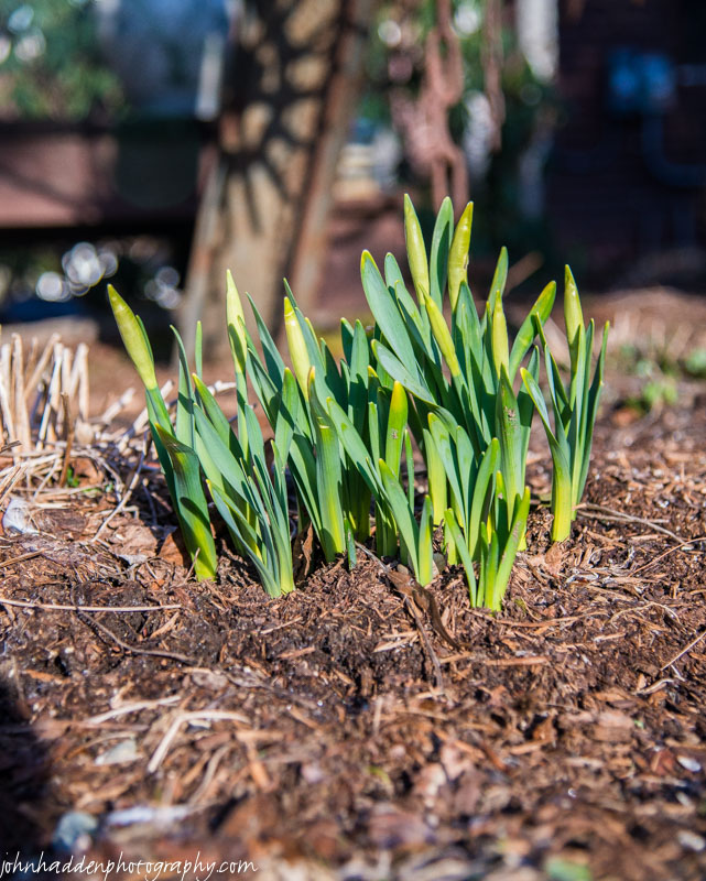
This morning’s light covering of snow will not deter the daffodils!
Morning Observation:
This morning in Huntington at 6:55AM it’s currently 32 degrees under overcast skies. A few lazy snowflakes are drifting down. Relative humidity is 83%, dewpoint 28, barometric pressure 29.78” and rising. We picked up 0.02” of rain and 1.25” of snow overnight. Yesterday’s high was 42, and the overnight low was 30.
Forecast:
The stubborn low pressure system that’s been bringing us our current round of cool and damp weather is parked over Maine this morning and will continue to rotate more of the same into our region for the next couple of days. We’ll see cloudy skies with a 50% chance of snow or rain showers this morning, then a chance of rain showers this afternoon. Highs will be in the lower 40s again today with northwest winds 10 to 15 mph. Tonight should be cloudy with a 50% chance of rain or snow showers until midnight, then a chance of snow showers after midnight. Lows in the lower 30s. Northwest winds 10 to 15 mph with gusts up to 25 mph.
Saturday should be cloudy with a chance of snow or rain showers in the morning, then a chance of rain showers in the afternoon. Highs will be in the upper 40s with northwest winds 10 to 15 mph. Chance of precipitation is 50%. Saturday night should be mostly cloudy with a 40% chance of rain showers. Lows will be in the mid 30s with northwest winds around 10 mph.
Sunday’s looking partly sunny with a 40% chance of rain showers. Highs will be in the lower 50s with northwest winds around 10 mph. Sunday night should be partly cloudy with a 40% chance of showers. Lows will be in the mid 30s.
Almanac:
Last year on this date we had a high of 51 and a low of 32. We picked up 0.03″ of rain.
Burlington norms for this date are highs of 59 and lows of 38.
The record high was 80°F in 2001.
The record low was 23°F in 1930.
Sky Notes:
Sunrise: 5:53 AM EDT
Sunset: 7:47 PM EDT
Length of Visible Light: 14h 55m
Length of Day: 13h 53m
Tomorrow will be 2m48s longer.
The Moon is a waxing crescent, 5d 16h old with 35% illumination.
Moonrise: 10:50 AM EDT
Moonset: 12:51 AM EDT
About Today’s Photo:
One of the clumps of emerging daffodils by the side of the house is undeterred by this morning’s snowfall… Spring will win!
Thursday, April 23, 2015

The weeping willow by our pond is starting to leaf out!
Morning Observation:
This morning in Huntington at 7:05AM it’s currently 35 degrees with a mix of snow and rain falling from overcast skies. Winds are calm. Relative humidity is 98%, dewpoint 34, barometric pressure 29.56” and rising. We picked up 0.49” of rain in the past 24hrs. Yesterday’s high was 54, and the overnight low was 35.
Forecast:
A large upper low pressure system centered across the eastern Great Lakes and southeastern Ontario this morning will be our controlling weather feature over the next 4 to 5 days as it moves very
slowly eastward. It will deliver a series of damp and seasonably cool days straight through the weekend.
We’ll see cloudy skies with a chance of rain or snow showers this morning, then a slight chance of rain showers this afternoon. Highs will be in the mid 40s with west winds 10 to 15 mph gusting up to 25 mph. Chance of precipitation is 50%. Tonight rain showers will be likely until midnight, then a chance of snow or rain showers likely after midnight. We may see total snow accumulations a dusting to 2 inches especially at elevations above 1000′. Lows will be around 30 with west winds 10 to 15 mph. Chance of precipitation is 70%.
Friday should be cloudy with a 40% chance of rain or snow showers in the morning, then a chance of rain showers in the afternoon. Highs will be in the mid 40s with northwest winds 10 to 15 mph gusting up to 25 mph. Friday night should be cloudy with a 50% chance of rain or snow showers. Lows will be in the lower 30s with northwest winds 10 to 15 mph gusting up to 30 mph.
Saturday’s looking cloudy with a 50% chance of rain or snow showers. Highs will be around 50 with northwest winds around 10 mph. Saturday night should be partly cloudy with a 30% chance of rain showers. Lows will be in the mid 30s.
Almanac:
Last year on this date we had a high of 49 and a low of 41. We picked up 0.19″ of rain.
Burlington norms for this date are highs of 59 and lows of 37.
The record high was 85°F in 1885.
The record low was 23°F in 1930.
Sky Notes:
Sunrise: 5:55 AM EDT
Sunset: 7:45 PM EDT
Length of Visible Light: 14h 52m
Length of Day: 13h 50m
The Moon is a waxing crescent, 4d 16h old with 26% illumination.
Moonrise: 9:54 AM EDT
Moonset: 12:02 AM EDT
About Today’s Photo:
It may not feel like spring this morning (of for the next couple of mornings for that matter) but things are happening! The weeping willow by our pond is starting to leaf out!
Wednesday, April 22, 2015

Willow buds popping in by our neighbor’s field
Happy Earth Day!
Morning Observation:
This morning in Huntington at 7:00AM it’s currently 33 degrees under mostly clear skies. Winds are calm. Relative humidity is 97%, dewpoint 32, barometric pressure 29.71”. We picked up 0.45” of rain in the past 24hrs. Yesterday’s high was 52, and the overnight low was 32.
Forecast:
A large upper level low pressure system across the Great Lakes and Ontario will drift slowly eastward through the end of the week. This system will bring seasonably cool conditions along with considerable cloudiness. Embedded smaller scale disturbances will bring periods of rain showers which will
be most widespread late today into tonight.
We’ll see partly sunny skies with a chance of rain showers this morning, then cloudy skies with rain showers this afternoon. Highs will be in the mid 50s with south winds 10 to 15 mph. Chance of rain is 90%. Rain will continue into tonight with a chance of snow showers over the mountains after midnight. Expect little or no snow accumulation. Lows will be in the mid 30s with west winds 10 to 15 mph. Chance of precipitation is 80%.
Thursday should be cloudy with a chance of rain or snow showers in the morning, then a chance of rain showers in the afternoon. Highs will only be in the upper 40s with west winds 10 to 15 mph. Chance of precipitation is 50%. Thursday night should be cloudy with a chance of rain or snow showers at elevations above 1000′. Lows will be in the lower 30s with west winds 10 to 15 mph gusting up to 30 mph. Chance of precipitation is 50%.
Friday should be cloudy with a chance of rain or snow showers. Highs will be in the mid 40s with west winds 10 to 15 mph. Chance of precipitation is 50%. Friday night should be cloudy with a 50% chance of rain or snow showers. Lows will be in the mid 30s.
Almanac:
Last year on this date we had a high of 66 and a low of 45.
Burlington norms for this date are highs of 58 and lows of 37.
The record high was 80°F in 1973.
The record low was 21°F in 1947.
Sky Notes:
Sunrise: 5:57 AM EDT
Sunset: 7:44 PM EDT
Length of Visible Light: 14h 49m
Length of Day: 13h 47m
Tomorrow will be 2m49s longer.
The Moon is a waxing crescent (beautifully paired with Venus yesterday evening!)
3d 16h old with 17% illumination.
Moonrise: 9:00 AM EDT
No Moon Set
About Today’s Photo:
I managed to get out and take a few photos yesterday afternoon between rain showers. These bejeweled willow buds were popping along the fenceline of our neighbor’s field.
Nikon D600, Sigma 105mm macro lens, ISO 1600, f/13, 1/500″ exposure
Tuesday, April 21, 2015
Willow buds waiting…
Morning Observation:
This morning in Huntington at 7:30AM it’s currently 48 degrees and raining lightly under overcast skies. Winds are out of the west at 4-6 mph. Relative humidity is 94%, dewpoint 46, barometric pressure 29.51” and falling rapidly. We picked up 0.38” of rain in the past 24hrs. Our top wind gust here yesterday was 38 mph which is just a little lower than our record of 43 mph in this protected hollow. Yesterday’s high was 51, and the overnight low was 46.
Forecast:
A large upper level low pressure system across the Great Lakes and Ontario will drift slowly eastward through the end of the week. This feature will provide the north country with seasonably cool
temperatures and considerable cloudiness.
An occluded front spun up by low pressure just to our south will push though the region this morning accompanied by rain showers. We’ll cloudy skies with showers likely mainly this morning, giving way to partly cloudy skies this afternoon. Highs will be in the upper 50s with south winds 10 to 15 mph, becoming westerly and gusting up to 25 mph this afternoon. Chance of rain is 70%. Tonight should be partly cloudy with lows in the upper 30s and southwest winds 10 to 15 mph.
Wednesday should be cloudy with a 50% chance of rain showers. Highs will be in the mid 50s with south winds 10 to 15 mph. Wednesday night Rain showers likely as a shortwave trough moves through. Lows will be in the mid 30s with west winds 10 to 15 mph gusting up to 30 mph. Chance of rain is 60%.
Thursday should be mostly cloudy with a 50% chance of rain showers. Highs will be in the upper 40s with west winds 10 to 15 mph gusting up to 30 mph. Thursday night should be cloudy with a 50% chance of rain or mountain snow showers. Lows will be in the mid 30s.
Almanac:
Last year on this date we had a high of 71 and a low of 45.
Burlington norms for this date are highs of 58 and lows of 37.
The record high was 83°F in 1977.
The record low was 18°F in 1908.
Sky Notes:
Sunrise: 5:58 AM EDT
Sunset: 7:43 PM EDT
Length of Visible Light: 14h 46m
Length of Day: 13h 44m
Tomorrow will be 2m52s longer.
The Moon is a waxing crescent, 2d 16h old with 10% illumination.
Moonrise: 8:10 AM EDT
Moonset: 11:06 PM EDT
About Today’s Photo:
Willow buds wait to burst in our front field…
Monday, April 20, 2015

Bloodroot starting to unfurl along Fargo Brook
Morning Observation:
This morning in Huntington at 6:40AM it’s currently a blustery 46 degrees under overcast skies. Winds are out of the southwest(ish) at 3-7 mph. Relative humidity is 55%, dewpoint 31, barometric pressure 30.04” and steady. Yesterday’s high was 57, and the overnight low was 45.
There is a High Wind Advisory in effect for our region from 8:00AM this morning until Midnight tonight. Power outages are a safe bet…
Forecast:
We’re in for and unsettled week weather-wise. Low pressure developing over the Great Lakes this morning will drag an occluded front through the region into tonight. Periods of light to moderate rainfall are expected with a brief break this afternoon when strong southeasterly winds develop along
and downwind of the higher summits. Unsettled weather will continue through the remainder of the week as an upper level trough takes up residence over the northeast bringing on and off valley rain and
mountain snow showers through the upcoming weekend.
We’ll see rain today. It’ll be very windy with highs in the upper 40s and southeast winds 25 to 35 mph gusting up to 50 mph and increasing to 60 mph this afternoon. Chance of rain near is 100%. Tonight should be partly cloudy with scattered showers until midnight, then showers likely with a slight chance of thunderstorms after midnight. It’ll continue to be very windy with lows in the mid 40s and southeast winds 25 to 35 mph gusting up to 55 mph, then diminishing to 20 to 25 mph with gusts up to 40 mph after midnight. Chance of rain is 70%.
Tuesday should be cloudy with showers likely and a slight chance of thunderstorms in the morning, then a chance of showers in the afternoon. Highs will be in the mid 50s with southwest winds around 10 mph. Chance of rain is 70%. Tuesday night should be partly cloudy with a 40% chance of showers. Lows will be in the upper 30s with southwest winds around 10 mph.
Wednesday’s looking mostly cloudy with a 50% chance of rain showers. Highs will be in the lower 50s with south winds around 10 mph. Wednesday night should be cloudy with a 50% chance of rain showers. Lows will be in the mid 30s.
Almanac:
Last year on this date we had a high of 60 and a low of 23. We picked up 0.09″ of rain.
Burlington norms for this date are highs of 57 and lows of 37.
The record high was 86°F in 1941.
The record low was 16°F in 1897.
Sky Notes:
Sunrise: 6:00 AM EDT
Sunset: 7:42 PM EDT
Length of Visible Light: 14h 43m
Length of Day: 13h 41m
Tomorrow will be 2m51s longer.
The Moon is a waxing crescent, 1d 15h old with 4% illumination.
Moonrise: 7:24 AM EDT
Moonset: 10:04 PM EDT
About Today’s Photo:
Bloodroot is one of the earliest spring ephemeral flowers to bloom. We have a clump down along the edge of Fargo Brook in our back yard. I love the way the blooms emerge from their tightly wrapped leaves.
Nikon D600, Sigma 105mm lens, ISO 2000, f/11, 1.60″ exposure.
Sunday, April 19, 2015

Dried Queen Anne’s Lace in the front field
Morning Observation:
This morning in Huntington at 7:00AM it’s currently 37 degrees under mostly cloudy skies. Winds are calm. Relative humidity is 83%, dewpoint 32, barometric pressure 30.27” and rising. We picked up 0.04” of rain in the past 24hrs. Yesterday’s high was 64, and the overnight low was 37.
Forecast:
High pressure building into the region this morning will deliver sunny skies and seasonable temperatures today. It’ll be the last sunny day for a while, so get out and enjoy it! We’ll see partly sunny skies this morning giving way to clear skies by midday. Highs will be in the upper 50s with northerly winds around 10 mph this morning, becoming light and variable. Tonight should be mostly clear until midnight, then become partly cloudy with lows in the upper 30s and east winds around 10 mph, becoming southeasterly 15 to 20 mph with gusts up to 35 mph after midnight.
Low pressure developing over the western Great Lakes will begin to effect us on Monday bringing rain and high winds. Highs in the upper 40s and southeast winds 15 to 25 mph gusting up to 50 mph, and increasing to 25 to 35 mph with gusts up to 60 mph in the afternoon. Chance of rain is near 100%. Rain will continue into Monday night. Lows in the lower 40s with southeast winds 25 to 35 mph gusting up to 55 mph. Chance of rain is 80%.
The aforementioned low will slide south of us Tuesday bringing more rain. Highs will be in the mid 50s with south winds 10 to 15 mph gusting up to 30 mph. Chance of rain is 70%. Tuesday night should be partly cloudy with a 30% chance of rain showers. Lows will be in the mid 30s.
Almanac:
Last year on this date we had a high of 49 and a low of 28. We picked up 0.08″ of rain.
Burlington norms for this date are highs of 57 and lows of 36.
The record high was 91°F in 1976.
The record low was 22°F in 1918.
Sky Notes:
Sunrise: 6:02 AM EDT
Sunset: 7:41 PM EDT
Length of Visible Light: 14h 40m
Length of Day: 13h 38m
Tomorrow will be 2m53s longer.
The Moon is a waxing crescent, 1d 16h old with 1% illumination.
Moonrise: 6:42 AM EDT
Moonset: 8:56 PM EDT
About Today’s Photo:
April often seems to be a month of waiting—waiting for the snow to melt, waiting for the green to begin. It’ll come, it’ll come…
Saturday, April 18, 2015

The wood frogs are back in the pond!
Morning Observation:
This morning in Huntington at 7:45AM it’s currently 39 degrees under partly cloudy skies. Winds are calm. Relative humidity is 98%, dewpoint 39, barometric pressure 29.94”. We picked up 0.07” of rain in the past 24hrs. Yesterday’s high was 65, and the overnight low was 34.
Forecast:
An upper level trough and weak surface low moving southeast through southern Canada will bring some scattered rain showers and possibly a few rumbles of thunder to the region today. High pressure will build into the region tonight and bring dry and seasonal conditions through the remainder of the weekend. We’ll see partly sunny skies this morning, then mostly cloudy skies with rain showers likely and a slight chance of thunderstorms this afternoon. Highs will be in the lower 60s with south winds around 10 mph, becoming westerly and gusting up to 30 mph this afternoon. Chance of rain is 70%. Saturday night should be mostly cloudy until midnight, then become partly cloudy. Lows will be around 30 with north winds 10 to 15 mph gusting up to 30 mph until midnight.
Sunday should be sunny with highs in the upper 50s and north winds around 10 mph in the morning, becoming light and variable. Sunday night should be partly cloudy with a 30% chance of rain showers as the next weather maker moves in. Lows will be in the upper 30s with southeast winds 15 to 20 mph with gusts up to 30 mph.
A surface low will move into the region Monday from the southwest bringing rain. It’ll be breezy with highs around 50 and southeast winds 15 to 25 mph gusting up to 55 mph. Chance of rain is 90%. Rain will continue into Monday night. Lows will be in the lower 40s. Chance of rain is 90%.
Almanac:
Last year on this date we had a high of 53 and a low of 26. We were snow-free once again.
Burlington norms for this date are highs of 56 and lows of 36.
The record high was 91°F in 1976.
The record low was 21°F in 1948.
Sky Notes:
Sunrise: 6:03 AM EDT
Sunset: 7:39 PM EDT
Length of Visible Light: 14h 37m
Length of Day: 13h 36m
Tomorrow will be 2m54s longer.
Astronomical Twilight 4:16 AM EDT 9:27 PM EDT
The Moon is new, 29d 2h old with 0% illumination.
Moonrise: 6:03 AM EDT
Moonset: 7:44 PM EDT
About Today’s Photo:
The ice finally melted off the pond the day before yesterday, and ,right on schedule, the wood frogs came back yesterday.
Friday, April 17, 2015
Daffodil shoots about ready to pop!
Morning Observation:
This morning in Huntington at 6:30AM it’s currently 45 degrees under overcasts skies. Winds are calm. Relative humidity is 95%, dewpoint 44, barometric pressure 29.97” and falling slowly. We picked up 0.11” of rain overnight. Yesterday’s high was 66, and the overnight low was 45.
Forecast:
We’ve got a fairly active next couple of days weather-wise. An upper level trough of low pressure will move across the region this morning bringing a few rain showers. We’ll see brief drying later today into tonight with some clearing, then another, more potent trough will drop down from Canada on Saturday bringing scattered to numerous showers to the region.
We’ll see cloudy and showers, mainly this morning. Highs will be in the mid 60s with southwest winds around 10 mph, becoming westerly this afternoon. Chance of rain is 80%. Tonight should be partly cloudy until midnight, then becoming mostly clear. Lows will be in the lower 40s with northwest winds around 10 mph until midnight, becoming light and variable.
Saturday should start out partly sunny with a chance of showers in the morning, then become cloudy with showers likely in the afternoon as the next trough and associated cold front moves through. Highs will be in the upper 50s with southwest winds around 10 mph, becoming northwesterly 15 to 20 mph and gusting up to 30 mph in the afternoon. Chance of rain is 60%. Saturday night should be partly cloudy with a 30% chance of rain showers. It’ll be seasonably cool with lows will be in the lower 30s and northwest winds 15 to 20 mph gusting up to 30 mph.
High pressure will build in for Sunday brining sunny skies with highs around 60 and north winds around 10 mph. Sunday night should be partly cloudy with lows in the upper 30s.
Almanac:
Last year on this date we had a high of 47 and a low of 15. We had 2.5″ of snow on the ground.
Burlington norms for this date are highs of 56 and lows of 36.
The record high was 90°F in 2002 (we had a high of 89).
The record low was 13°F in 1971.
Sky Notes:
Sunrise: 6:05 AM EDT
Sunset: 7:38 PM EDT
Length of Visible Light: 14h 34m
Length of Day: 13h 33m
Tomorrow will be 2m54s longer.
The Moon is a waning crescent, 28d 1h old with 3% illumination.
Moonrise: 5:27 AM EDT
Moonset: 6:30 PM EDT
About Today’s Photo:
The first daffodil shoots in one of our side gardens are about to pop!
Thursday, April 16, 2015
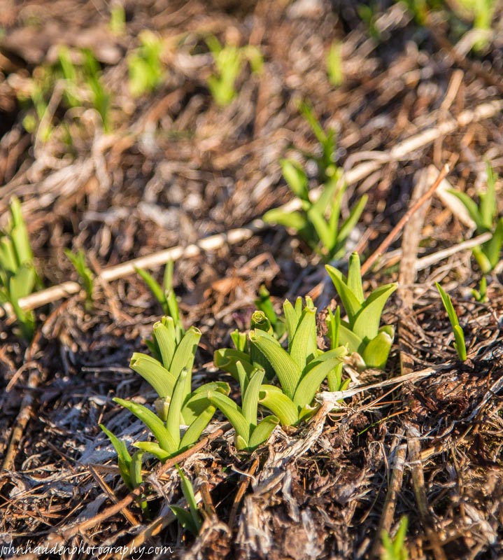
Daylily shoots popping up over by the pond
Morning Observation:
This morning in Huntington at 7:05AM it’s currently 27 degrees under clear skies. Winds are calm. Relative humidity is 90%, dewpoint 24, barometric pressure 30.47” and rising. Yesterday’s high was 55, and the overnight low was 25.
Forecast:
A large area of high pressure sitting over southern New England this morning will bring mostly mostly sunny skies and dry conditions to the region today Sunny. It’ll be warmer with highs in the mid 60s and light and variable winds, becoming southerly around 10 mph this afternoon. Tonight should be partly cloudy until midnight, then mostly cloudy with showers after midnight as a weak shortwave trough moves in from the Great Lakes. Lows will be in the lower 40s with south winds 15 to 20 mph. Chance of rain is 80%.
Friday should be cloudy with showers, mainly in the morning. Highs will be in the lower 60s with southwest winds 10 to 15 mph, becoming westerly in the afternoon. Chance of rain is 80%. Friday night should be partly cloudy with lows in the lower 40s and northwest winds around 10 mph.
A shortwave trough will skirt to our north on Saturday bringing partly sunny skies with a 40% chance of showers. Highs will be in the lower 60s with west winds 15 to 20 mph gusting up to 30 mph. Saturday night should be partly cloudy with lows in the mid 30s.
Almanac:
Last year on this date we had a high of 32 and a low of 18. We picked up 1.4″ of rain and 5.25″ of snow. Ah April…
Burlington norms for this date are highs of 55 and lows of 35.
The record high was 86°F in 2002 (we had a high of 85).
The record low was 18°F in 1908.
Sky Notes:
Sunrise: 6:07 AM EDT
Sunset: 7:37 PM EDT
Length of Visible Light: 14h 30m
Length of Day: 13h 30m
Tomorrow will be 2m55s longer.
The Moon is a waning crescent, 27d 1h old with 8% illumination.
Moonrise: 4:52 AM EDT
Moonset: 5:15 PM EDT
About Today’s Photo:
Daylily shoots are popping up over by our pond. It looks like these were nibbled on a bit by some critter as they came out of the ground…
Wednesday, April 15, 2015
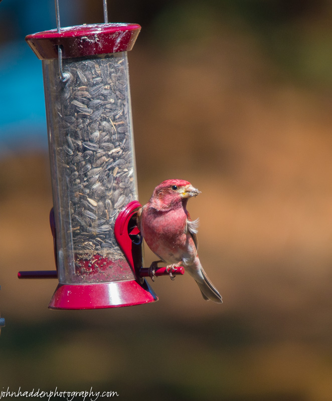
A purple finch visits our feeder
Morning Observation:
This morning in Huntington at 7:10AM it’s currently 29 degrees under mostly clear skies. Winds are calm. Relative humidity is 95%, dewpoint 28, barometric pressure 30.19” and rising rapidly. Yesterday’s high was 63, and the overnight low was 28.
Forecast:
A large region of Canadian high pressure will bring mostly clear and dry conditions through Thursday. We’ll see sunny skies today with highs in the upper 50s and northwest winds 15 to 20 mph. Tonight should be clear and seasonably chilly with lows in the lower 20s and northwest winds 10 to 15 mph.
Thursday should be sunny and mild with highs in the mid 60s and light and variable winds, becoming southerly around 10 mph in the afternoon as the high moves to the east and puts us in a southerly airflow. Thursday night should be partly cloudy with a 30% chance of showers as a shortwave trough approaches form the Great Lakes. Lows will be in the upper 30s with south winds 10 to 15 mph.
Friday’s looking mostly cloudy with a 50% chance of showers. Highs will be around 60 with southwest winds 10 to 15 mph. Friday night should be partly cloudy with lows in the lower 40s.
Almanac:
Last year on this date we had a high of 64 and a low of 26. We picked up 0.05″ of rain.
Burlington norms for this date are highs of 55 and lows of 35.
The record high was 82°F in 2003 (we had a high of 80).
The record low was 18°F in 1926.
Sky Notes:
Sunrise: 6:08 AM EDT
Sunset: 7:36 PM EDT
Length of Visible Light: 14h 27m
Length of Day: 13h 27m
Tomorrow will be 2m56s longer.
The Moon is a waning crescent, 26d 1h old with 15% illumination.
Moonrise: 4:16 AM EDT
Moonset: 4:01 PM EDT
About Today’s Photo:
A group of purple finches has arrived in the neighborhood. They’ve been hanging around the feeders for the past couple of days. Their bright color rivals that of the cardinals this time of year.
Tuesday, April 14, 2015

Spring runoff in Fargo Brook
Morning Observation:
This morning in Huntington at 6:55AM it’s currently 37 degrees under mostly clear skies. Winds are calm. Relative humidity is 96%, dewpoint 36, barometric pressure 30.08” and rising rapidly. We picked up 0.24” of rain overnight. Yesterday’s high was a barefootin’ 73, and the overnight low was 37.
Forecast:
The cold front that brought the overnight rains has moved east of our region this morning, and high pressure is currently building in. We’ll see partly sunny skies today. It’ll be breezy with highs in the lower 60s and west winds 15 to 25 mph gusting up to 35 mph. Tonight should be clear with lows in the lower 30s and west winds 15 to 20 mph gusting up to 30 mph then diminishing to around 10 mph after midnight.
Wednesday should be sunny with highs in the upper 50s and northwest winds 15 to 20 mph gusting up to 30 mph. Wednesday night should be clear with lows in the mid 20s and north winds 15 to 20 mph.
Thursday’s looking sunny with highs in the mid 60s and south winds around 10 mph. A weak trough will slide through Thursday night bringing partly cloudy skies and a 40% chance of showers. Lows will be around 40.
Almanac:
Last year on this date we had a high of 80 and low of 43. We picked up 0.29″ of rain.
Burlington norms for this date are highs of 54 and lows of 34.
The record high was 84°F in 1968.
The record low was 17°F in 1923.
Sky Notes:
Sunrise: 6:10 AM EDT
Sunset: 7:34 PM EDT
Length of Visible Light: 14h 24m
Length of Day: 13h 24m
Tomorrow will be 2m56s longer.
The Moon is a waning crescent, 25d 1h old with 25% illumination.
Moonrise: 3:39 AM EDT
Moonset: 2:47 PM EDT
About Today’s Photo:
Spring runoff and rainfall make Fargo Brook roar!
Nikon D600, Nikon 24-120mm lens @ 70mm, circular polarizing filter, ISO 50, f/9, 1/10″ exposure.
Monday, April 13, 2015

A newly arrived song sparrow in the buckeye tree by our back deck
Morning Observation:
This morning in Huntington at 6:50AM it’s currently 33 degrees under clear skies. Winds are calm. Relative humidity is 94%, dewpoint 32, barometric pressure 30.27”. Our snow stake is finally snow-free! Yesterday’s high was a lovely 64, and the overnight low was 31.
Forecast:
We have a lovely day on tap folks! A low pressure system approaching from the upper Great Lakes will put us in a southerly airflow today. We’ll see sunny skies with highs in the lower 70s and south winds 15 to 20 mph. The low and its attendant cold front will move through tonight brining mostly cloudy skies with showers likely mainly after midnight. It’ll be windy with lows in the mid 40s and south winds 20 to 30 mph, becoming southwesterly 20 to 25 mph after midnight. Chance of rain is 60%.
High pressure will build in behind the departing cold front on Tuesday bringing partly sunny skies with a 40% chance of showers in the morning. Highs will be in the upper 50s with west winds 15 to 20 mph. Tuesday night should be clear with lows in the mid 30s and west winds 10 to 15 mph.
Wednesday’s looking sunny with highs in the mid 50s and northwest winds 10 to 15 mph gusting up to 25 mph. Wednesday night should be clear with lows in the lower 30s.
Almanac:
Last year on this date we had a high of 66 and a low of 39. We picked up 0.10″ of rain.
Burlington norms for this date are highs of 54 and lows of 34.
The record high was 84°F in 1945.
The record low was 16°F in 1914.
Sky Notes:
Sunrise: 6:12 AM EDT
Sunset: 7:33 PM EDT
Length of Visible Light: 14h 21m
Length of Day: 13h 21m
Tomorrow will be 2m58s longer.
Then Moon is a waning crescent, 24d 1h old with 36% illumination.
Moonrise: 2:59 AM EDT
Moonset: 1:36 PM EDT
About Today’s Photo:
The song sparrows is one of the earliest spring harbingers for us. Its lovely song blends nicely with robin and phoebes in the early morning.
Nikon D600, Sigma 120-400mm lens @ 400mm, ISO 800, f/5.6, 1/3200″ exposure.
Sunday, April 12, 2015

The tip of a hobble-bush branch emerges from the snow
Morning Observation:
This morning in Huntington at 8:05AM it’s currently 36 degrees (and climbing fast!) under clear skies. Winds are calm. Relative humidity is 90%, dewpoint 33, barometric pressure 30.23” and rising. We have about 2” of snow left at the stake. Yesterday’s high was 48, and the overnight low was 26.
Forecast:
We got us a batch o’ lovely spring days ahead of us folks! High pressure moving off the mid-Atlantic coast today will help to deliver sunny with highs around 60 and west winds around 10 mph. Tonight should be clear with lows in the upper 30s and south winds around 10 mph.
Monday should be sunny with highs in the upper 60s to near 70 degrees with south winds 10 to 15 mph. A cold front will swing through Monday night brining showers. Lows will be in the lower 40s with south winds 15 to 20 mph gusting up to 30 mph. Chance of rain is 70%.
Tuesday should be partly sunny with a 50% chance of showers in the morning before high pressure builds back in behind the departing front. Highs will be in the upper 50s with west winds 15 to 20 mph. Tuesday night should be mostly clear with lows in the mid 30s.
Almanac:
Last year on this date we had a high of 61 and a low of 28.
Burlington norms for this date are highs of 53 and lows of 34.
The record high was 82°F in 1945.
The record high was 16°F in 1926.
Sky Notes:
Sunrise: 6:13 AM EDT
Sunset: 7:32 PM EDT
Length of Visible Light: 14h 18m
Length of Day: 13h 18m
Tomorrow will be 2m58s longer.
The Moon is a waning crescent, 23d 2h old with 46% illumination.
Moonrise: 2:16 AM EDT
Moonset: 12:28 PM EDT
About Today’s Photo:
There’s still a lot of snow up in the high country above 2000′. Hobble-bush (Viburnum lantanoides) is emerging from the snowpack and starting to push out its leaves.
Saturday, April 11, 2015

A hungry robin nabs a worm in our front yard
Morning Observation:
This morning in Huntington at 6:30AM it’s currently a blustery 40 degrees under mostly cloudy skies. Winds are out of the west at 5-8 mph. Relative humidity is 68%, dewpoint 30, barometric pressure 29.71” and rising. We picked up 0.13” of rain in the past 24hrs and have about 3” of rapidly dwindling snow at the stake (which is one of the few places on the property that still has any snow at all…) Yesterday’s high was 54, and the overnight low was 40.
Forecast:
Clouds associated with an upper level shortwave trough moving over the area this morning may produce
some light rain or snow showers in the mountains. We’ll see cloudy skies this morning, then partly sunny skies this afternoon as the trough moves east and drier air settles in. Highs will be in the upper 40s with west winds 15 to 20 mph gusting up to 30 mph. Tonight should be mostly clear with lows in the lower 30s and west winds 15 to 20 mph, diminishing to around 10 mph after midnight.
High pressure over the Ohio River valley will deliver sunny skies on Sunday with highs around 60 and west winds around 10 mph (that sounds delightful!) Sunday night should be clear with lows in the upper 30s and southwest winds around 10 mph.
Monday should start out mostly sunny. A gusty southerly airflow will deliver highs in the mid 60s out ahead of an approaching cold front. Winds will be out of the south at 15 to 20 mph with gusts up to 30 mph. Monday night showers are likely as the cold front moves through. Lows will be in the lower 40s. Chance of rain is 70%.
Almanac:
Last year on this date we had a high of 61 and a low of 31. Our snowpack was finally gone, and bluebirds and tree swallows had returned. Let’s see if they stay on schedule this year…
Burlington norms for this date are highs of 53 and lows of 33.
The record high was 84°F in 1945.
The record low was 12°F in 1974.
Sky Notes:
Sunrise: 6:15 AM EDT
Sunset: 7:31 PM EDT
Length of Visible Light: 14h 15m
Length of Day: 13h 15m
Tomorrow will be 2m58s longer.
The Moon is in its last quarter tonight, currently 22d 1h old with 58% illumination.
Moonrise: 1:28 AM EDT
Moonset: 11:24 AM EDT
About Today’s Photo:
The robins have been around intermittently for the past week or so, but now they’re here in earnest. This hungry one found a worm in our front yard—yum!
Friday, April 10, 2015

The headwaters of Fargo Brook up near Bert’s Crown
Morning Observation:
This morning in Huntington at 7:15AM it’s currently 40 degrees and raining lightly under overcast skies. Winds are calm. Relative humidity is 90%, dewpoint 38, barometric pressure 29.90” and falling. We picked up 0.16” of rain overnight. Snow at the stake is down to 7.5 icy inches. Yesterday’s high was 41, and the overnight low was 40.
Forecast:
Low pressure currently centered out over the Great Lakes will lift a warm front and then a cold front through the region in the next 24 hours. We’ll see cloudy skies with rain likely this morning. A brief break in the precipitation later this morning will be followed by more rain showers with a slight chance of thunderstorms this afternoon. Highs will be in the mid 50s to near 60 with south winds 15 to 20 mph gusting up to 30 mph. Chance of rain is 70%. Tonight should be mostly cloudy with a 30% chance of rain showers until midnight, then partly cloudy after midnight as the cold front moves through. Lows will be in the mid 30s with southwest winds 15 to 20 mph gusting up to 30 mph.
Saturday should be mostly cloudy with a 20% chance of rain showers. Highs will be in the mid 40s with west winds 15 to 20 mph gusting up to 30 mph. Saturday night should be partly cloudy with lows in the lower 30s and west winds 10 to 15 mph gusting up to 25 mph.
High pressure will build in for Sunday’s bringing sunny skies and highs in the mid 50s with west winds around 10 mph. Sunday night should be clear with lows in the upper 30s.
At this point it looks like next week will bring us a string of days reaching into the 60s. Looks like winter may have finally packed his bags!
Almanac:
Last year on this date we had a high of 60 and a low of 23. We picked up 0.02″ of rain and had 2″ of snow at the stake.
Burlington norms for this date are highs of 52 and lows of 33.
The record high was 81°F in 1945.
The record low was 16°F in 1975.
Sky Notes:
Sunrise: 6:17 AM EDT
Sunset: 7:30 PM EDT
Length of Visible Light: 14h 12m
Length of Day: 13h 12m
Tomorrow will be 2m59s longer.
The Moon is waning gibbous, 21d 1h old with 68% illumination.
Moonrise: 12:36 AM EDT
Moonset: 10:25 AM EDT
About Today’s Photo:
Winter is releasing the land and the water is flowing up at the headwaters of Fargo Brook just below Bert’s Crown.
Thursday, April 9, 2015

A view of Camel’s Hump from Bert’s Crown
Morning Observation:
This morning in Huntington at 6:10AM it’s currently 32 degrees under overcast skies. Winds are light and variable. Relative humidity is 76%, dewpoint 25, barometric pressure 30.33”. We picked up 2” of new snow during the evening yesterday and have 10” at the stake. Yesterday’s high was 44, and the overnight low was 31.
Forecast:
A few lingering snow showers this morning will be accompanied by cloudy and seasonably cool weather before a strong warm front pushes through the region tonight with additional rain expected into Friday. Temperatures will be considerably milder and above normal on Friday before a cold front brings cooler air for Saturday with temperatures around normal.
We’ll see cloudy skies with a slight chance of rain, sleet, or snow showers this morning, then a slight chance of rain this afternoon. Highs will be in the lower 40s with southeast winds 10 to 15 mph. Chance of precipitation is 20%. Warmer air will begin pushing into the region tonight bringing
rain and breezy conditions with lows in the upper 30s and southeast winds 15 to 25 mph. Chance of rain is 90%.
Rain will continue into Friday with a slight chance of thunderstorms in the morning, then showers likely with a slight chance of thunderstorms in the afternoon. Highs will be in the upper 50s with south winds 15 to 20 mph. Chance of rain is 80%. We should see a fair amount of rain in this system—on the order of an inch or so. Friday night should be partly cloudy with a 40% chance of rain showers. Lows will be in the upper 30s with southwest winds 15 to 20 mph gusting up to 35 mph.
The aforementioned cold front will move through overnight. We’ll see mostly cloudy skies Saturday with a 40% chance of rain showers in the morning. Highs will be seasonable in the upper 40s with west winds 15 to 20 mph gusting up to 30 mph. Saturday night should be partly cloudy with lows in the lower 30s.
At this point it’s looking like we’re heading into spring folks with daytime highs near 60 for the bulk of next week!
Almanac:
Last year on this date we had a high of 44 and low of 35. We picked up 0.06″ of rain and had 2″ at the stake.
Burlington norms for this date are highs of 51 and lows of 32.
The record high was 76°F in 1945.
The record low was 14°F in 1997.
Sky Notes:
Sunrise: 6:19 AM EDT
Sunset: 7:28 PM EDT
Length of Visible Light: 14h 09m
Length of Day: 13h 09m
Tomorrow will be 3m0s longer.
The Moon is waning gibbous, 20 days old with 78% illumination.
No Moon Rise
Moonset: 9:33 AM EDT
About Today’s Photo:
I skied up to the higher elevations of the Camel’s Hump Ski Center yesterday morning. I found myself at the foot of Bert’s Crown, a rocky knob that rises up to the west of the Lion’s Ridge area. Having never climbed to the top of the Crown, I took advantage of the firm snowpack to scramble my way up. I was not disappointed with the view! The Hump, Crow Hill, and Bald Hill are laid out quite nicely. The Crown was named for Bert White whom some of you might remember for his kind, folksy manner and ubiquitous yellow hard hat.
Wednesday, April 8, 2015

A broken stem emerges from the snow
Morning Observation:
This morning in Huntington at 6:45AM it’s currently a brisk 20 degrees under mostly clear skies. Winds are calm. Relative humidity is 90%, dewpoint 18, barometric pressure 30.44”. We have 9” of snow at the stake and an open front field. Yesterday’s high was 45, and the overnight low was 20.
Forecast:
Cool surface high pressure will slide off to the east today while our old surface frontal boundary which has been waffling about the area for the better part of the week drifts northward once again. A wave of low pressure will slide though the region later today bringing a mixed bag of precipitation. We’ll see partly sunny skies this morning, then cloudy skies with a 50% chance of rain this afternoon. Highs will be in the lower 40s with light and variable winds, becoming southeasterly around 10 mph this afternoon. Rain will continue into tonight possibly mixing with snow until midnight, then snow likely after midnight. We may see snow accumulations of 1 to 3 inches. Lows will be in the upper 20s with southeast winds around 10 mph. Chance of precipitation is 90%.
Thursday should start out with a 40% chance of snow showers or a slight chance of rain showers in the morning, then rain showers in the afternoon. Highs will be in the lower 40s with southeast winds around 10 mph. A vigorous low pressure system will approach the region from the Great Lakes on Thursday night along with a warm front that will finally drive the wavy frontal boundary to our north We’ll see rain overnight with lows in the upper 30s and south winds 15 to 20 mph gusting up to 30 mph. Chance of rain is 80%.
By Friday we’ll begin to see a marked change in the weather pattern as the warm front pushes though the region. We’ll see rain with highs in the upper 50s to near 60 and south winds 10 to 15 mph gusting up to 25 mph. Chance of rain is 80% and we may even hear a few rumbles of thunder! Friday night should be partly cloudy with a 40% chance of rain showers. Lows will be in the upper 30s.
At this point it looks like we may be out of the winter woods going into next week with seasonably mild temperatures expected going into next week.
Almanac:
Last year on this date we had a high of 57 and a low of 36. We picked up 0.33″ of rain and had 7″ of snow at the stake. We had our first thunderstorm of the spring season as well.
Burlington norms for this date are highs of 51 and lows of 32.
The record high was 73°F in 1991.
The record low was 11°F in 1972.
Sky Notes:
Sunrise: 6:21 AM EDT
Sunset: 7:27 PM EDT
Length of Visible Light: 14h 05m
Length of Day: 13h 06m
Tomorrow will be 2m59s longer.
The Moon is waning gibbous, 19d 1h old with 85% illumination.
Moonrise: 11:40 PM EDT
Moonset: 8:48 AM EDT
About Today’s Photo:
A little bit of minimalist photography today. A broken stem creates an interesting shadow in the fading snow of our front field.
Tuesday, April 7, 2015

A view of the Huntington River from the East Street bridge
Morning Observation:
This morning in Huntington at 6:50AM it’s currently 33 degrees under overcast skies. Winds are calm. Relative humidity is 97%, dewpoint 32, barometric pressure 30.31” and rising slowly. Though it snizzled and snowed pretty much all day yesterday, we have only a trace of new snow on the measuring board and 10” at the stake. Yesterday’s high was 37, and the overnight low was 33.
Forecast:
A weak surface wave associated with the wavering cold front that delivered yesterday’s precipitation is moving to our east this morning. We’ll see cloudy skies with a 20% chance of snow showers this morning, then partly sunny skies this afternoon. Highs will be in the lower 40s with light and variable winds, becoming northerly around 10 mph this afternoon. Tonight should be mostly clear until midnight, then become partly cloudy. Lows will be in the lower 20s with north winds around 10 mph until midnight, becoming light and variable.
Wednesday should start out partly sunny in the morning, then become cloudy with a 40% chance of rain showers in the afternoon as yet another surface wave rides east along the wavering frontal boundary as it lifts north again. Highs will be in the lower 40s with light and variable winds. Wednesday night should be cloudy with a 50% chance of rain or snow showers. Lows will be in the lower 30s with southeast winds around 10 mph.
A move vigorous low and associated warm front will push into the region from the Great Lakes on Thursday bringing cloudy skies with a 40% chance of rain showers. Highs will be in the mid 40s with southeast winds 10 to 15 mph gusting up to 25 mph. Thursday night rain showers are likely lows in the mid 30s. Chance of rain is 70%. This low will mark the beginning of a pattern change for us as we’ll very likely finally bid adieu to the persistent cold that we’ve been experiencing for the past several months. Believe it or not, we may be seeing spring — and mud season — finally arrive. Stay tuned!
Almanac:
Last year on this date we had a high of 59 and a low of 26. We had 9.5″ of snow at the stake.
Burlington norms for this date are highs of 50 and lows of 32.
The record high was 83°F in 1991.
The record low was 2°F in 1972.
Sky Notes:
Sunrise: 6:22 AM EDT
Sunset: 7:26 PM EDT
Length of Visible Light: 14h 02m
Length of Day: 13h 03m
Tomorrow will be 3m1s longer.
The Moon is waning gibbous, 18d 1h old with 92% illumination.
Moonrise: 10:42 PM EDT
Moonset: 8:08 AM EDT
About Today’s Photo:
Here’s another view of the Huntington River running milky with spring runoff. Standing on the East Street bridge, the roar of the water is a welcome sound!
