Sunday, January 7, 2024

 The confluence of Brush Brook and the Huntington River
Morning Observation:
This morning in Huntington at 6:55AM it’s currently 26 degrees and snowing lightly under overcast skies. Winds are out of the west at 3-7 mph. Relative humidity is 89%, dewpoint 23, barometric pressure 29.77”. We picked up a scant 0.80” of new snow so far and have 1” at the stake. Yesterday’s high was 29, and yesterday’s low was 22. The overnight low got down to 26.
This morning in North Hero it’s currently 27 degrees and snowing lightly under overcast skies. Winds are calm. Relative humidity is 92%, dewpoint 25, barometric pressure 29.85”. We picked up 3” of new snow and have 3” at the stake. Yesterday’s high was 32, and yesterday’s low was 18. The overnight low got down to 21.
A Winter Weather Advisory remains in effect for our region until 7:00PM tonight.
A High Wind Watch has been posted for our region from 10:00PM Tuesday until 1:00PM Wednesday.
Forecast Discussion:
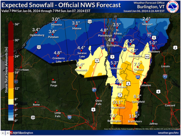
Well, that was some lackluster overnight snow… Morning snow totals are starting to trickle in, but the general trend looks like this storm is “underperforming” in terms of snowfall amounts. Morning radar imagery appears to indicate that the coastal low responsible—currently off the coast of Long Island—seems to have petered out significantly. The NWS says that we’ll see some more snowfall during the day today with perhaps another 1″-3″ here in Huntington, and 2″-5″ over southern Vermont. I’ll believe it when I’m shoveling it… Regardless, snowfall is expected to taper off later this evening with a smattering of “backside bonus” snow over northern upslope mountains into tonight. High pressure is expected to build in on Monday bringing dry and seasonable conditions into Tuesday. Then we prepare for our next storm system. As I mentioned in yesterday’s discussion, this looks like a doozy, and the NWS suggests that one use Monday as a day to quite literally “batten down the hatches” in preparation for the high wind event expected Tuesday night into Wednesday.
Low pressure moving out of the Mississippi River valley on Tuesday is expected to track through the Great Lakes on Wednesday. The low’s track will put us on the warm side of the storm and bring in some strong to damaging winds as we’re squeezed between the low and high pressure pinned over far eastern Québec. The NWS is not mincing words with about the winds predicting 50-60 mph gusts over the western slopes of the Greens (that’s Huntington), with gust as high as 70-80 mph over mountain summits. That’s edging into hurricane force folks. Precipitation should start out as a period of heavy wet snow later Tuesday before transitioning to rain by Wednesday morning. Most of the snow is likely to fall over southern Vermont (3″-6″) with little or none as you head towards the Canadian border. Rainfall in the range of 0.75″-1.5″ is expected with this system as temperatures climb into the mid to upper 40 on Wednesday. This combined with snowmelt will help to push area rivers to near flood stage with cresting expected early Thursday. Post storm, unsettled conditions are expected to persist heading into the weekend with seasonably mild temperatures and a bit of snow possible Thursday night and another messy storm later in the weekend.
3-Day Forecast:
We’ll see cloudy skies today with snow. Highs will be near 26 with east winds 5-8 mph becoming calm in the morning. Chance of precipitation is 100% with daytime snow accumulations of 1″-3″ possible. Tonight should be cloudy with snow likely, mainly before 2:00AM. Lows will be around 19 with calm winds becoming northwesterly 5-8 mph after midnight. Chance of precipitation is 70% with new snow accumulations of around 1″ possible.
Monday should be mostly cloudy with a slight chance of mooning snow. Highs will be near 30 with northwest winds 6-9 mph. Monday night should be mostly cloudy with a low around 15 and northwest winds 5-7 mph becoming calm after midnight.
Tuesday should be cloudy with a 40% chance of afternoon snow. Highs will be near 35 with southeast wind 5-10 mph in the morning. Little or no snow accumulation is expected. Tuesday night should be cloudy with snow before 10:00PM, then rain after midnight. Lows will be around 30 with southeast winds 20-30 mph increasing to 30-40 mph after midnight. Winds could gust as high as 60 mph. Chance of precipitation is 100% with rainfall amounts between 0.50”-0.75” possible.
Almanac:
Last year on this date in Huntington we had a high of 35 and a low of 19. We picked up 0.10″ of snow and had 0.10″ at the stake.
Last year in North Hero we had a high of 38 and a low of 21. We picked up 0.01″ of rain.
Burlington averages for this date are a low of 14 and a high of 30.
The record low was -20 in 2018. (We had a low of -24 in Huntington with 14.5″ of snow at the stake.)
The record high was 54 in 1946.
The Lake Champlain lake level in Burlington is 98.40′.
The water temperature is 38˚.
Last year’s lake level was at 97.16′.
The Mt. Mansfield snow stake depth is 20″.
The average depth for this date is 36″.
Mt. Washington Summit Conditions
Current Temperature: 6
Winds are out of the southeast at 24-26 mph
24 hr Precipitation: 3.5″ snow, 0.38″ melted precipitation
Visibility: around 1/16 mile snow and freezing fog
Sky Notes:
Sunrise: 7:27AM
Sunset: 4:28PM
Length of day: 9:01:30
Today will be 1:12 longer than yesterday.
The Moon is a waning crescent, 25 days old with 20% illumination.
Moonrise: 3:36AM
Moonset: 12:48PM
About Today’s Photo:
Brush Brook’s clear, green-tinted waters flow into the Huntington River in Huntington Center. Evidence of past flooding is plain to see in the extensive gravel bars along the brook.
DJI Mini 3 drone, ISO 100, f/1.7, 1/3000″ exposure
Saturday, January 6, 2024

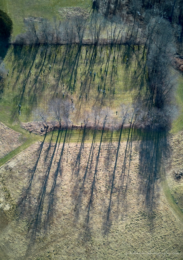 Shadows stretch across the Huntington Center cemetery
Morning Observation:
This morning in Huntington at 6:40AM it’s currently 25 degrees under cloudy skies. Winds are calm. Relative humidity is 87%, dewpoint 22, barometric pressure 30.21”. We picked up a dusting of new snow in the past 24hrs and have 0.4” at the stake. Yesterday’s high was 27, and yesterday’s low was 6. The overnight low got down to 24.
This morning in North Hero it’s currently 19 degrees under clear skies. Winds are light out of the northwest. Relative humidity is 77%, dewpoint 13, barometric pressure 30.32”. Still snowless. Yesterday’s high was 32, and yesterday’s low was 13. The overnight low got down to 19.
There is a Winter Weather Advisory in place for Huntington 7:00PM tonight until 7:00PM Sunday.
Forecast Discussion:
Well folks, we’ve got a very impactful and roller-coastery period of weather ahead of us from tonight and into the upcoming week. Quite a lot to talk about so bear with me… Low pressure currently over Georgia is expected to ride up the coast in the next 24 hours bringing widespread snowfall to the North Country tonight through Sunday. Current forecast models are indicating a more northerly track for the storm which means more snow for us up here in northern parts of Vermont. Consequently, Winter Storm Warnings are now in place for southern Vermont counties with Advisories posted for northern counties. After a dry and seasonable day today, snow is expected to move into the region tonight and continue through much of Sunday. At this time, the NWS is calling for 1″-4″ for far northern counties along the International Border, with 3″-6″ for north-central Vermont, 6″-10″ for for central Vermont, and finally 6″-12″ for Rutland, Windsor, and Orange counties. The low is expected to quickly depart Sunday night with little or now “backend bonus” expected. Monday’s looking good for snow activities with highs in the upper 29s. Enjoy the snow while you can because our next storm system is very likely to take it all away once again (please don’t kill the messenger…) A potent and messy storm system is expected to track out of the Mississippi River valley on Tuesday and to our west through the Great Lakes Wednesday. This will put us firmly on the warm side of the storm and bring us multiple weather hazards. Precipitation is expected to start out as snow Tuesday afternoon as temperatures rise into the mid 30s. Snow is expected to change over to rain overnight Tuesday with some potential icing where stubborn cold air is still in place (hazard #1). Winds will also be on the increase overnight as we’re squeezed between the low to our west and high pressure to our east. This impressive “pressure gradient” will create some potentially dangerous downsloping wind along the western slopes of the Greens and ‘Dacks Tuesday night into Wednesday. Gusts of 45-55 mph are not out of the question (hazard #2). Rain will continue into Wednesday and become heavy at times. With temperatures in the mid to upper 40s, high winds, and rainfall, all the lovely snow that fell on Sunday will likely melt and head to our rivers and streams where some flooding is possible again (hazard #3). Rain is expected to wind down Wednesday night with a bit of snow in its wake overnight. There’s yet another storm system on the horizon for Friday, but I’ll stop there for now. Phew!
3-Day Forecast:
We’ll see cloudy skies today with a high near 27 and north wind around 6 mph becoming calm. Tonight should be cloudy with snow, mainly after 9:00PM. Lows will be around 22 with southeast winds 6-12 mph. Chance of precipitation is 90% with new snow accumulations of 2″-4″ possible.
Sunday should be cloudy with snow. Highs will be near 26 with northeast winds 6-9 mph. Chance of precipitation is 90% with new snow accumulations of 1″-3″ possible. Sunday night should be cloudy with snow likely, mainly before 7:00PM. Lows will be around 20 with northwest winds around 6 mph. Chance of precipitation is 60% with new snow accumulation of less than 0.50″ possible.
Monday should be mostly cloudy with a high near 29 and northwest winds 6-8 mph. Monday night should be mostly cloudy with a low around 15 and northwest winds around 6 mph becoming calm after midnight.
Almanac:
Last year on this date in Huntington we had a high of 42 and a low of 34. We picked up 0.08″ of rain.
Last year in North Hero we had a high of 40 and a low of 33. We picked up 0.04″ of rain.
Burlington averages for this date are a low of 15 and a high of 30.
The record low was -23 in 1996.
The record high was 62 in 2007 (we had a high of 62 in Huntington).
The Lake Champlain lake level in Burlington is 98.50′.
The water temperature is 38˚.
Last year’s lake level was at 97.00′.
The Mt. Mansfield snow stake depth is 27″.
The average depth for this date is 35″.
Mt. Washington Summit Conditions
Current Temperature: 2
Winds are out of the northwest at 29 gusting to 35 mph
24 hr Precipitation: 1.5″ snow, 0.14″ melted precipitation
Visibility: about 80 miles with undercast
Sky Notes:
Sunrise: 7:27AM
Sunset: 4:27PM
Length of day: 9:00:17
Today will be 1:08 longer than yesterday.
The Moon is a waning crescent, 24 days old with 29% illumination.
Moonrise: 2:24AM
Moonset: 12:20PM
About Today’s Photo:
The low January midday sun casts long shadows from the trees edging the cemetery in Huntington Center.
DJI Mini 3 drone, ISO 100, f/1.7, 1/2000″ exposure
Friday, January 5, 2024

 Camel’s Hump and Wind Gap from above Bald Hill’s shoulder
Morning Observation:
This morning in Huntington at 7:30AM it’s currently a brisk 8 degrees under mostly clear skies. Winds are calm. Relative humidity is 91%, dewpoint 5, barometric pressure 30.24”. We picked up 0.40” of new snow yesterday and have 0.40” at the stake. Yesterday’s high was 34, and yesterday’s low was 14. The overnight low got down to 6.
This morning in North Hero it’s currently 13 degrees under partly cloudy skies. Winds are out of the north at 2-4 mph. Relative humidity is 82%, dewpoint 8, barometric pressure 30.34”. No snow on the ground. Yesterday’s high was 36, and yesterday’s low was 16. The overnight low got down to 13.
Forecast Discussion:
Outside of some light snow streamers coming off of Lake Champlain this morning, we’ll see dry and mostly sunny conditions today with temperatures recovering nicely from frigid morning lows into the mid 20s. A weak cold front is expected to dip though the region tonight bringing some increasing clouds and a slight chance of snow showers. Deepening low pressure is expected to move off the Delmarva Peninsula Saturday afternoon and head up the coast though the day. Forecast models have continued to trend towards a more northwesterly track for this storm, bringing it just outside/over the Cape Cod “benchmark” before it chugs out to sea. At this point, Winter Storm Watches have been posted for north to Rutland and Windsor counties in Vermont where 6″-8″ of new snow may fall during the day on Sunday. Accumulations will drop off significantly as you head north with 3″-5″ expected over central Vermont and 1″-2″ along the International border. This is, of course, subject to change given the storm’s track, but there’ pretty high confidence that we’ll at least be seeing some snow here in Huntington! Woo-hoo! The storm is expected to move quickly out to sea Sunday night into early Monday with little or no “backside bonus” expected. After a dry and seasonably mild day on Monday, a potentially potent storm system is expected to impact the region Tuesday into Wednesday. Unfortunately, this looks like a non-snow-friendly event. Deep low pressure tracking out the of the Mississippi River valley is expected to track up through the Great Lakes on Wednesday putting us well in the warm sector with a surge of warm air bringing in first snow Tuesday afternoon, then mixed precipitation overnight, then rain on Wednesday as temperatures bump up into the mid 40s. Potentially strong downsloping winds are likely over the western slopes of the Greens and ‘Dacks as well. Ugh. Like all things weather-wise, this is subject to change, but get your snow ya-yas out while you can…
3-Day Forecast:
We’ll see mostly sunny skies today with a high near 26 and northwest winds 8-10 mph becoming southwesterly in the afternoon. Tonight should be mostly cloudy with a 20% chance of snow showers late. Lows will be around 22 with southwest winds 5-7 mph becoming light and variable after midnight.
Saturday should be cloudy with a high near 28 and northeast winds 5-10 mph. Saturday night should be cloudy with snow likely, mainly after 11:00PM. Lows will be around 23 with southeast winds around 9 mph. Chance of precipitation is 70% with new snow accumulations of 1″-2″ possible.
Sunday should be cloudy with snow, mainly before 4:00PM. Highs will be near 29 with east winds 5-7 mph becoming light and variable in the afternoon. Chance of precipitation is 80% with new snow accumulations of 1″-3″ possible. Sunday night should be cloudy with a 30% chance of snow before 7:00PM. Lows will be around 20 with northwest winds around 6 mph.
Almanac:
Last year on this date in Huntington we had a high of 44 and a low of 35. We picked up 0.37″ of rain.
Last year in North Hero we had a high of 41 and a low of 31. We picked up 0.40″ of rain.
Burlington averages for this date are a low of 15 and a high of 30.
The record low was -17 in 1996.
The record high was 57 in 1950.
The Lake Champlain lake level in Burlington is 98.56′.
The water temperature is 39˚.
Last year’s lake level was at 96.71′.
The Mt. Mansfield snow stake depth is 24″.
The average depth for this date is 35″.
Mt. Washington Summit Conditions
Current Temperature: -6
Winds are out of the northwest at 61-65 mph
24 hr Precipitation: 0.9″ snow, 0.16″ melted precipitation
Visibility: around 60 miles
Sky Notes:
Sunrise: 7:27AM
Sunset: 4:26PM
Length of day: 8:59:09
Today will be 1:04 longer than yesterday.
The Moon is a waning crescent, 23 days old with 38% illumination.
Moonrise: 1:16AM
Moonset: 11:57AM
About Today’s Photo:
I launched my drone from the Burrows Trail parking lot the other day to capture this portrait of Camel’s Hump and Wind Gap from just above the southern shoulder of Bald Hill. You can clearly make out the two drainages that the Burrows and Forest City trails climb along.
DJI Mini 3 drone, ISO 100, f/1.7, 1/4000″ exposure
Thursday, January 4, 2024

 Portrait of a village
Morning Observation:
This morning in Huntington at 7:45AM it’s currently 33 degrees under cloudy skies. Winds are calm. Relative humidity is 90%, dewpoint 30, barometric pressure 29.85”. We picked up a dusting of snow overnight. Yesterday’s high was 37, and yesterday’s low was 30. The overnight low got down to 32.
This morning in North Hero it’s currently 31 degrees under cloudy skies. Winds are light out of the north. Th is 91%, dewpoint 29, barometric pressure 29.91”. Yesterday’s high was 38, and yesterday’s low was 33. The overnight low got down to 31.
Forecast Discussion:
Morning radar imagery shows a sharp cold front moving through Vermont at this hour with some attendant snow showers. Some showers may be briefly squall-like this morning so be alert if you’re out driving. Any accumulations should be minor with less than an inch in valley locations and perhaps 1″-4″ as you head to the highest mountain summits. Shower activity should wind down later this afternoon and become relegated to northern upslope mountain areas. Temperatures should top out this morning and drop into the 20s by this afternoon. Indeed we’re already seeing the drop in North Hero. Tonight should be quite quite chilly—in the single digits to low teens—as high pressure builds in. Friday’s looking mostly sunny with a high in the upper 20s. A weak cold front is expected to swing through Friday night bringing some light snow showers. Saturday should start out dry and seasonable with building clouds out ahead of our next weather-maker. Forecast models are in better agreement regarding the track of a coastal low, showing it clipping or inside (landward) of the Cape Cod “benchmark” by Sunday morning. However, with no blocking high downstream, the storm is expected to be progressive and track easterly out to sea and not hook up the New England coast. This means that far southern Vermont and southern New England will be the big winners picking up some accumulating snow. Snowfall amounts will drop off sharply heading north with only light accumulations forecast for the Burlington area at this time. If the storm takes a westerly jog, however, we may see more snow up here. Fingers crossed… Snow showers will likely continue into Monday with perhaps a little “backside bonus” over higher western slopes. Chilly high pressure is expected to build in behind the departing on Monday. Another low is expected to move out of the Mississippi River valley and into the Great Lakes Tuesday night. At this point, temperature profiles are on the iffy side meaning we might see some rain (sorry), mixed precipitation (sorry), or snow from the event. Stay tuned…
3-Day Forecast:
We’ll see cloudy skies today with snow showers likely, mainly before noon. Temperature should top out this morning and fall to around 22 by 5:00PM with southwest winds 6-14 mph becoming northwesterly in the afternoon. Chance of precipitation is 70% with daytime snow accumulations of 1″-2″ possible. Tonight should be mostly cloudy with a low around 13 and northwest winds 7-13 mph.
Friday should be mostly sunny with a high near 27 and northwest winds around 7 mph becoming southwesterly in the afternoon. Friday night should be mostly cloudy with a low around 21 and southwest winds around 7 mph becoming northwesterly after midnight.
Saturday should be cloudy with a 30% chance of afternoon snow showers. Highs will be near 28 with light and variable winds. Little or no snow accumulation is expected. Saturday night should be cloudy with snow showers likely. Lows will be around 23 with southeast winds 6-8 mph. Chance of precipitation is 70%.
Almanac:
Last year on this date in Huntington we had a high of 43 and a low of 35. We picked up 0.52″ of rain.
Last year in North Hero we had a high of 39 and a low of 35. We picked up 0.88″ of rain.
Burlington averages for this date are a low of 15 and a high of 30.
The record low was -27 in 1981 (brrrr!)
The record high was 63 in 1950.
The Lake Champlain lake level in Burlington is 98.68′.
The water temperature is 40˚.
Last year’s lake level was at 96.60′.
The Mt. Mansfield snow stake depth is 22″.
The average depth for this date is 34″.
Mt. Washington Summit Conditions
Current Temperature: 12
Winds are out of the west at 35-39 mph
24 hr Precipitation: 0.4″ snow, 0.05″ melted precipitation
Visibility: less than 1/16 mile with blowing snow and freezing fog
Sky Notes:
Sunrise: 7:27AM
Sunset: 4:25PM
Length of day: 8:58:04
Today will be 0:59 longer than yesterday.
The Moon is a waning crescent, 22 days old with 48% illumination.
Moonrise: 12:11AM
Moonset: 11:39AM
About Today’s Photo:
Huntington Center looks neat and tidy below the rimed ridgeline of Camel’s Hump and Ira & Ethan Allen. Hopefully we’ll see a more snowy landscape in the next few days…
DJI Mini 3 drone, ISO 100, f/1.7, 1/2000″ exposure
Wednesday, January 3, 2024

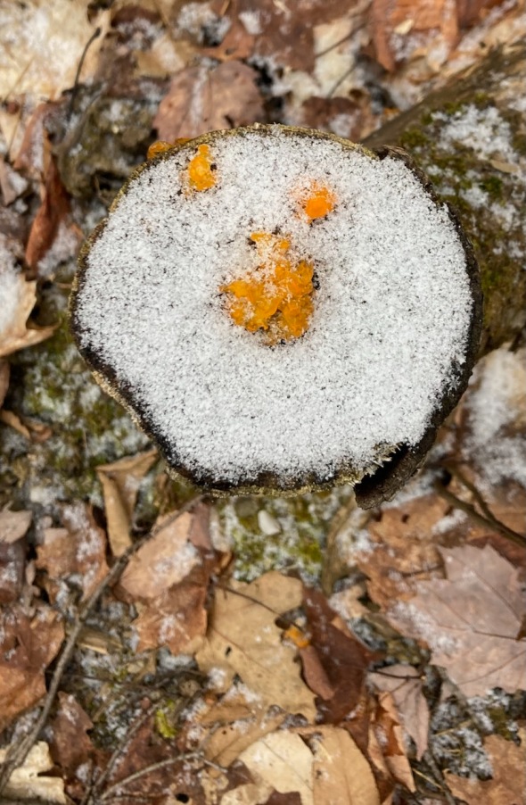 Orange jelly fungus and snow. Fried eggs anyone? (Photo Matthew Witten)
Morning Observation:
This morning in Huntington at 6:30AM it’s currently 30 degrees under cloudy skies. Winds are calm. Relative humidity is 94%, dewpoint 29, barometric pressure 29.95”. Yesterday’s high was 34, and yesterday’s low was 15. The overnight low got down to 24.
This morning in North Hero it’s currently 36 degrees under cloudy skies. Winds are calm. Relative humidity is 81%, dewpoint 30, barometric pressure 29.96”. Yesterday’s high was 36, and yesterday’s low was 24. The overnight low got down to 33.
Forecast Discussion:
A weak upper level shortwave trough is poised to swing through the region today, but outside of some lake effect snow showers over St. Lawrence county and far northern New York, little or no snow impact is expected in Vermont. Another trough is expected to slide through tonight bringing some snow showers over west-facing slopes of the ‘Dacks and northern Greens where a dusting to a couple inches may fall. A sharp cold front is expected to sweep through the region Thursday morning bringing the potential for small-like snow showers with 1″-2″ of snow possible in Huntington. Daytime highs on Thursday will top out around 30 in the morning and drop in the afternoon. High pressure and a modified Arctic airmass will move in behind the departing front bringing a chilly night Thursday night with lows dropping into the low teens and single digits along with gusty northwest winds. Friday’s looking seasonably cool and dry. A weak cold front is expected to move through Friday night into Saturday bringing some light scattered snow showers. Our attention then turns to a developing coastal low that is expected to impact the region Saturday night into Sunday. At this point, forecast models aren’t quite in agreement with the storm’s track. The Canadian model is the most aggressive with a more northerly and westerly track (meaning more snow for us…) while the Global and European models show a more progressive easterly track with snow staying mostly to our south. Only time will tell. Stay tuned…
3-Day Forecast:
We’ll see mostly cloudy skies today with a high near 37 and south winds 6-9 mph. Tonight should be mostly sunny with a 20% chance of snow showers late. Lows will be around 26 with south winds 6-10 mph.
Thursday should be mostly cloudy with a 50% chance of snow showers. Highs will top out around 30 in the morning and drop to around 22 by 5:00PM with southwest winds 6-13 mph becoming northwesterly 15-20 mph in the afternoon. New snow accumulations of 1″-2″ are possible. Thursday night should be partly cloudy with a low around 12 and northwest winds 7-14 mph.
Friday should be sunny with a high near 24 and southwest winds 8-11 mph. Friday night should be mostly cloudy with a low around 19 and west winds 3-6 mph.
Almanac:
Last year on this date in Huntington we had a high of 41 and a low of 26. We picked up 0.04″ of rain.
Last year in North Hero we had a high of 39 and a low of 35.
Burlington averages for this date are a low of 15 and a high of 30.
The record low was -21 in 1981.
The record high was 55 in 2000.
The Lake Champlain lake level in Burlington is 98.72′.
The water temperature is 39˚.
Last year’s lake level was at 96.24′.
The Mt. Mansfield snow stake depth is 22″.
The average depth for this date is 33″.
Mt. Washington Summit Conditions
Current Temperature: 15
Winds are out of the west at 35 mph gusting to 48 mph.
24 hr Precipitation: 0
Visibility: ~70 miles in blowing fog
Sky Notes:
Sunrise: 7:27AM
Sunset: 4:24PM
Length of day: 8:57:05
Today will be 0:55 longer than yesterday.
The Moon is in its last quarter, 21 days old with 57% illumination.
No Moonrise
Moonset: 11:22AM
About Today’s Photo:
My friend and long-time musical collaborator, Matthew Witten, came across this interesting bit of orange jelly fungus on the top of a stump dusted with snow. Kinda looks like someone cooked up a fried egg in the woods…
iPhone SE
Tuesday, January 2, 2024

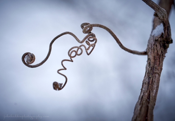 A twist of grape vine by the road…
Morning Observation:
This morning in Huntington at 7:30AM it’s currently 15 degrees under clear skies. Winds are calm. Relative humidity is 93%, dewpoint 14, barometric pressure 30.09”. Despite persistent “flaking” all day yesterday, we have just a trace of snow on the ground. Yesterday’s high was 23, and yesterday’s low was 21. The overnight low got down to 15.
This morning in North Hero it’s currently 26 degrees under clear skies. Winds are out of the south at 8-12 mph. Relative humidity is 88%, dewpoint 23, barometric pressure 30.13”. We have a dusting of snow on the ground. Yesterday’s high was 24, and yesterday’s low was 23. The overnight low got down to 24.
Forecast Discussion:
Finally some sun! High pressure cresting over the region today will bring us some long-missed sunshine for a good part of the day today with highs bumping up into the mid 36. Clouds will be on the increase tonight, however, out ahead of a weak trough which should bring a a dusting to maybe an inch of snow to northern Vermont mountains overnight. Scattered and isolated Lake Ontario effect and northern mountain snow showers will continue through Wednesday. With valley highs in the mid to upper 30, some mixing with rain is possible. An additional inch or two may fall over northern mountains Wednesday with valley locations staying mostly dry. A cold front is expected to drop through the region on Thursday kicking off some light snow shower activity in its passage. Daytime highs on Thursday are expected to top out in the low 30s in the morning and fall in the afternoon with the frontal passage. Dry and seasonably chilly conditions are expected Friday into Saturday. Attention then turns to a potential coastal storm that may impact the region on Sunday. Forecast models are currently showing that the low’s track will pass somewhere in the vicinity of the Cape Cod benchmark, but whether or not the storm hooks up the New England coast is still in doubt. Stay tuned…
3-Day Forecast:
We’ll see sunny skies today with a high near 36 and south winds around 10 mph. Tonight should be mostly cloudy with a low around 26 and south winds 8-12 mph.
Wednesday should be mostly cloudy with a high near 37 and southwest winds around 6 mph. There’s a slight chance of afternoon rain and snow showers in North Hero. Wednesday night should be cloudy with a 30% chance of snow showers late. Lows will be around 26 with south winds around 6 mph. New snow accumulations of less than 0.50″ are possible.
Thursday should be mostly cloudy with a 40% chance of snow showers before 3:00PM. Highs will be near 31, falling in the afternoon with southwest winds 5-11 mph becoming northwesterly in the afternoon. New snow accumulations of less than 0.50″ are possible. Thursday night should be partly cloudy with a low around 13 and northwest winds 8-14 mph.
Almanac:
Last year on this date in Huntington we had a high of 41 and a low of 28.
Last year in North Hero we had a high of 46 and a low of 35.
Burlington averages for this date are a low of 16 and a high of 31.
The record low was -21 in 1968.
The record high was 51 in 2000.
The Lake Champlain lake level in Burlington is 98.80′.
The water temperature is 40˚.
Last year’s lake level was at 96.43′.
The Mt. Mansfield snow stake depth is 22″.
The average depth for this date is 33″.
Mt. Washington Summit Conditions
Current Temperature: 15
Winds are out of the at 38 mph gusting to 45 mph
24 hr Precipitation: 0
Visibility: 130+ under mostly clear skies.
Sky Notes:
Sunrise: 7:27AM
Sunset: 4:24PM
Length of day: 8:56:09
Today will be 0:51 longer than yesterday.
The Moon is waning gibbous, 20.5 days old with 66% illumination.
Moonrise: 11:08PM
Moonset: 11:06AM
About Today’s Photo:
This twist of wild grape vine caught my eye. Sometimes it’s just the little things…
Sony A7II, Sony 90mm macro lens, ISO 800, f/5.6, 1/250″ exposure
Monday, January 1, 2024

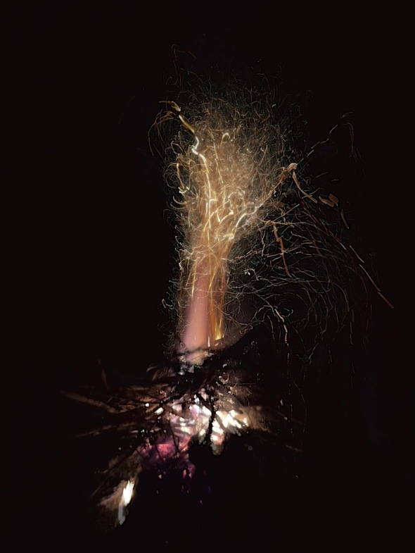 Sparks fly from our neighbor’s New Year’s bonfire
Happy New Year! Rabbit-rabbit!
Morning Observation:
This morning in Huntington at 6:35AM it’s currently 21 degrees under cloudy skies. Winds are calm. Relative humidity is 83%, dewpoint 17, barometric pressure 30.07”. We picked up just a trace of snow overnight. Yesterday’s high was 26, and yesterday’s low was 23. The overnight low got down to 21.
This morning in North Hero it’s currently 24 degrees under cloudy skies. Winds are calm. Relative humidity is 82%, dewpoint 19, barometric pressure 30.14”. We have a dusting of snow at the stake. Yesterday’s high was 28, and yesterday’s low was 24. The overnight low got down to 24.
Forecast Discussion:
If you live in a couple of very small and focused areas near the Route 108 and Route 100/I-89 corridors, New Year’s Eve brought you an unexpected snow dump of 6″-8″ overnight. I’m still waiting for the CoCoRaHS reports to come in (observations are usually posted around 7:00AM), but this is a prime example of Vermont’s “all weather is local” microscale weather environment as certain spots got the goods with bare ground just yards away. Amazing. If you don’t live in one of those magical snow globe zones, you got nuthin’, and dry and seasonable conditions will be the rule today with highs in the mid 20s to low 30s. Hopefully we’ll finally see some sunshine today to usher in the New Year. Quiet conditions are expected for much of the upcoming week for Vermont with highs in the 30s on Tuesday. A bit of a warmup is expected for Wednesday as a trough slides through bringing some widespread rain and snow showers during the day. Unsettled conditions will persist into Thursday with minimal impacts. A trough is expected to pass to our north Friday into Saturday with minimal impacts expected for Vermont. Forecast models are beginning to line up for a more potent storm system impacting the region on Sunday, but it’s too far out to have any kind of certainty. Stay tuned with your fingers crossed!
3-Day Forecast:
We’ll see cloudy skies this morning with scattered snow showers, mainly before noon. Skies should gradually become mostly sunny with a high near 25 and calm winds becoming northerly around 5 mph. Chance of precipitation is 50% with little or no snow accumulation expected. Tonight should be partly cloudy with a low around 18 and light and variable winds.
Tuesday should be sunny with a high near 35 with south winds 5-10 mph. Tuesday night should bring increasing clouds with a low around 26 and south winds 6-12 mph.
Wednesday should be cloudy with a chance of afternoon rain and snow showers. Highs will be near 37 with southwest winds 5-7 mph. Chance of precipitation is 30% with little or no snow accumulation expected. Wednesday night should be cloudy with a 40% chance of snow showers. Lows will be around 25 with south winds around 6 mph.
Almanac:
Last year on this date in Huntington we had a high of 51 and a low of 42. We picked up 0.22″ of rain.
Last year in North Hero we had a high of 46 and a low of 35. We picked up 0.06″ of rain.
Burlington averages for this date are a low of 16 and a high of 31.
The record low was -17 in 1970.
The record high was 56 in 1966.
The Lake Champlain lake level in Burlington is 98.89′.
The water temperature is 41˚.
Last year’s lake level was at 96.03′.
The Mt. Mansfield snow stake depth is 22″.
The average depth for this date is 33″.
Mt. Washington Summit Conditions
Current Temperature: 8
Winds are out of the northwest at 31-35 mph
24 hr Precipitation: 0
Visibility: ~70 miles between undercast and high clouds
Sky Notes:
Sunrise: 7:27AM
Sunset: 4:23PM
Length of day: 8:55:18
Today will be 0:46 longer than yesterday.
The Moon is waning gibbous, 19.6 days old with 75% illumination.
Moonrise: 10:06PM
Moonset: 10:49AM
About Today’s Photo:
We rang in the New Year last night (well almost—didn’t make it to midnight…) at our neighbors with convivial cheer and a big bonfire. The sparks danced as they climbed high into the dark sky!
iPhone 15 Pro, 3″ exposure, Spectre ap
