Tuesday, January 31, 2017

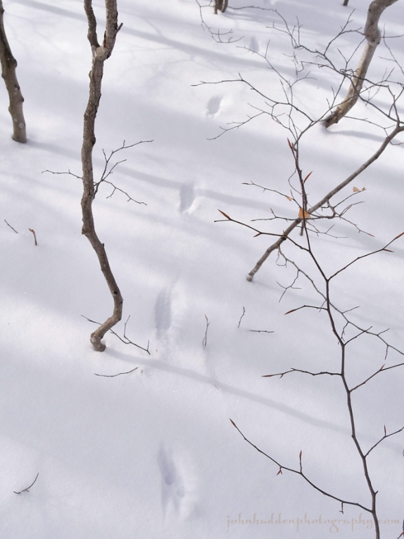
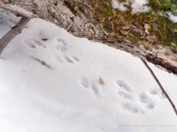
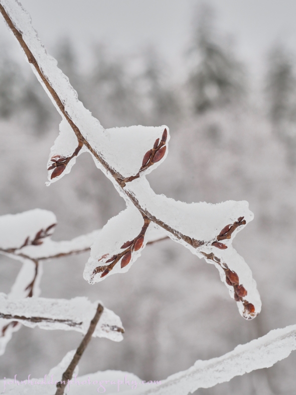
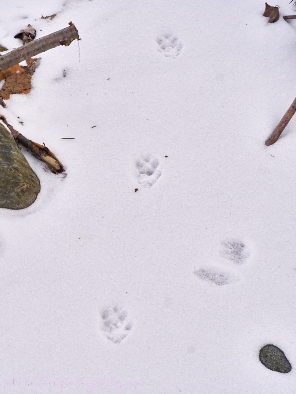
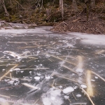
Ermine tracks in fresh snow
Morning Observation:
This morning in Huntington at 7:45AM it’s currently 1 degree under clear skies. Winds are calm. Relative humidity is 87%, dewpoint -2, barometric pressure 29.94”. We picked up 0.5” of new snow overnight and have 3” at the stake. Yesterday’s high was 26, and the overnight low was 0.
Forecast:
Weak high pressure over the region this morning will give way to a clipper low that will track to our south bringing widespread light snowfall tonight night and Wednesday. The second half of the week looks quiet under a persistent northwest flow that will deliver with some light snow showers mainly in the higher elevations. Seasonable temperatures are expected to start February but trend colder than normal as we head toward the weekend.
We’ll see partly sunny skies today with highs in the lower 20s and light and variable winds. Tonight should be mostly cloudy with light snow likely mainly after midnight. We could see snow accumulations of a dusting to 2″ overnight with highest amounts south. Lows will be around 18 with light and variable winds. Chance of snow is 70%.
Wednesday should bring light snow with total snow accumulations of 1″ to 3″ with highest amounts south and east. Highs will be in the upper 20s with light and variable winds. Chance of snow is 80%. Wednesday night should be cloudy with a 50% chance of snow showers. Lows will be around 18 with southwest winds around 10 mph.
Thursday’s looking cloudy with a 30% chance of snow showers as a weak cold front swings through. Highs will be in the lower 20s with west winds 10 to 15 mph. Thursday night should be partly cloudy with lows 5 to 10 above.
Almanac:
Last year on this date we had a high of 51 and a low of 29. We had 4.75″ of snow at the stake.
Burlington averages for this date are highs of 28 and lows of 10.
The record high was 56°F in 1988.
The record low was -27°F in 1920.
Sky Notes:
Sunrise: 7:10 AM EST
Sunset: 5:00 PM EST
Length of Visible Light: 10h 51m
Length of Day: 9h 49m
Tomorrow will be 2m30s longer.
The Moon is a waxing crescent, 3.3 days old with 12% illumination.
Moonrise: 9:09 AM EST
Moonset: 9:13 PM EST
About Today’s Photo:
While skiing around Crow Hill the other day, I came across a set of ermine (short-tailed weasel) tracks. The critter was bounding about investigating under logs and around trees. The photo (top) shows a typical set of tracks with the ermine headed towards the camera. The photo below shows the tracks up close where it had paused briefly under a log.
Monday, January 30, 2017


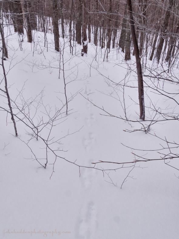
Minimalist still life with snow
Morning Observation:
This morning in Huntington at 7:40AM it’s currently 22 degrees and snowing lightly under overcast skies. Winds are calm. Relative humidity is 82%, dewpoint 17, barometric pressure 29.73”. We picked up a 0.30” dusting of snow and graupel in the past 24hrs, and have 2.5” at the stake. Yesterday’s high was 37, and the overnight low was 22.
Forecast:
An upper level trough is swinging through the region this morning bringing some snow showers. Weak high pressure will move in today with cooler, near seasonable temperatures. The next organized system will be a clipper low that tracking to our south Wednesday and bringing widespread light snowfall. The second half of the week should be rather quiet as temperatures will hover just above near normal to start February.
We’ll see mostly cloudy skies today with a 30% chance of snow showers mainly this morning. Highs will be in the lower 20s with light and variable winds, becoming northwesterly around 10 mph this afternoon. Tonight should be mostly cloudy with a 20% chance of snow showers until midnight. Lows will be around 6 above with northwest winds around 10 mph.
Tuesday should be partly sunny in the morning, then beceom mostly cloudy with a 20% chance of light snow in the afternoon. Highs will be in the lower 20s with light and variable winds. Tuesday night should be mostly cloudy with a 50% chance of snow. Lows will be around 16 with light and variable winds.
Wednesday’s looking cloudy with a 50% chance of snow. Highs will be in the mid 20s with light and variable winds. Wednesday night should be mostly cloudy with lows around 15.
Almanac:
Last year on this date we had a high of 38 and a low of 21. We picked up 3.85″ of new snow and had 5.75″ at the stake.
Burlington averages for this date are highs of 28 and lows of 10.
The record high was 57°F in 2013 (we had a high of 59).
The record low was -20°F in 1948.
Sky Notes:
Sunrise: 7:12 AM EST
Sunset: 4:59 PM EST
Length of Visible Light: 10h 49m
Length of Day: 9h 47m
Tomorrow will be 2m29s longer.
The Moon is a waxing crescent, 2.3 days old with 6% illumination.
Moonrise: 8:37 AM EST
Moonset: 8:05 PM EST
About Today’s Photo:
Pausing for a moment in my ski around Crow Hill yesterday morning, my eye was drawn by the simplicity of this arrangement of snow and half buried shrubs.
Panasonic GX8, Lumix 14-140mm lens @ 26mm, ISO 800, f/9, 1/160″ exposure.
Sunday, January 29, 2017

A nice set of fisher tracks in fresh snow
Morning Observation:
This morning in Huntington at 8:00AM it’s currently 30 degrees under mostly cloudy skies. Winds are out of the west at 2-6 mph. Relative humidity is 74%, dewpoint 23, barometric pressure 29.55”. Snowpack is 2.5”. Yesterday’s high was 35, and the overnight low was 30.
Forecast:
An upper level trough and associated weak disturbance in the winds aloft will combined with a surface cold front to produce scattered snow showers through tonight. A dusting to several inches of accumulation is possible. Weak high pressure with colder temperatures are expected for Monday before a clipper
system brings widespread light snow for midweek.
We’ll see cloudy skies today with snow showers likely mainly this afternoon. Total snow accumulations could be 1″ to 3″. Highs will be in the lower 30s with southwest winds 10 to 15 mph. Chance of snow is 70%. Tonight should be mostly cloudy with a 50% chance of snow showers. Lows will be around 18 with west winds around 10 mph.
Monday should be mostly cloudy with a 20% chance of snow showers. Highs will be in the lower 20s with northwest winds around 10 mph. Monday night should be partly cloudy with lows around 7 above and west winds around 10 mph.
Tuesday’s looking mostly cloudy with a 40% chance of snow showers. Highs will be in the mid 20s with light and variable winds. Tuesday night should be cloudy with a 40% chance of snow showers. Lows will be around 15.
Almanac:
Last year on this date we had a high of 36 and a low of 24. We had 2.5″ of snow at the stake.
Burlington averages for this date are highs of 27 and lows of 10.
The record high was 49°F in 1950.
The record low was -18°F in 1954.
Sky Notes:
Sunrise: 7:13 AM EST
Sunset: 4:57 PM EST
Length of Visible Light: 10h 46m
Length of Day: 9h 44m
Tomorrow will be 2m28s longer.
The Moon is a waxing crescent, 1.3 days old with 2% illumination.
Moonrise: 8:04 AM EST
Moonset: 6:58 PM EST
About Today’s Photo:
We skied in an inch or two of fresh snow up at Camel’s Hump Nordic yesterday. There were many kinds of tracks to be seen including this fine set up fisher tracks loping up the hill (towards the camera) and across the trail. The photo below shows the tracks up close with my ski for scale.
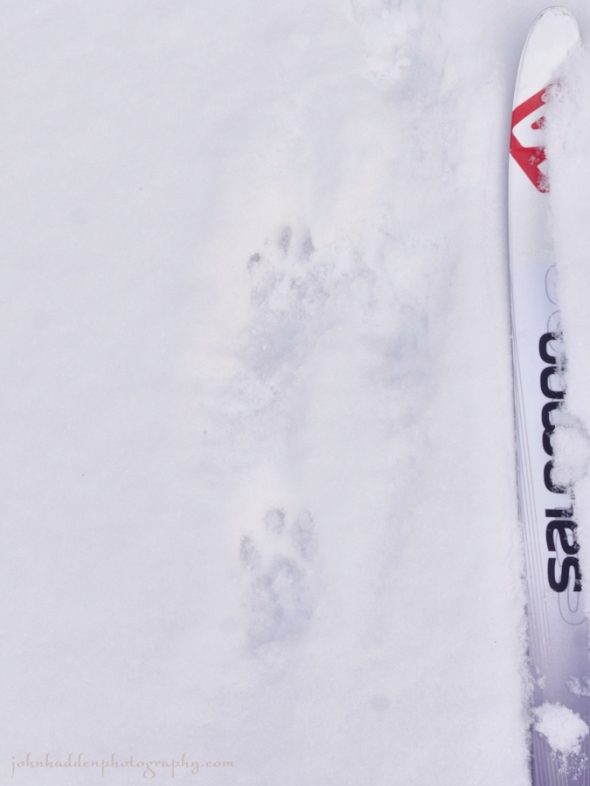
Fisher tracks up close
Saturday, January 28, 2017


This chickadee with a ivory bill and white flecks in its black cap visited our feeder the other day
Morning Observation:
This morning in Huntington at 9:00AM it’s currently 29 degrees and snowing lightly under overcast skies. Winds are out of the west at 2-5 mph. Relative humidity is 72%, dewpoint 21, barometric pressure 29.50”. We picked up 0.25” of light fluff overnight and have 2.5” at the stake. Yesterday’s high was 34, and the overnight low was 27.
Forecast:
A trough of low pressure draped across the northeast will continue to bring rounds of snow showers through the region especially late tonight into Sunday. Several more inches of snow in the mountains can be expected by Sunday evening before a brief break in the action occurs on Monday. A clipper like system will arrive late Tuesday into Wednesday bringing widespread light snow.
We’ll see cloudy skies today with a 50% chance of snow showers. Highs will be in the lower 30s with west winds 10 to 15 mph. Tonight should be mostly cloudy with a 50% chance of snow showers. Lows will be in the mid 20s with southwest winds around 10 mph.
Sunday snow showers are likely with snow accumulations of a dusting to 2″ possible. Highs will be around 30 with southwest winds around 10 mph. Chance of snow is 70%. Sunday night snow showers are likely with little or no additional snow accumulation. Lows will be around 14 with northwest winds around 10 mph. Chance of snow is 60%.
Monday’s looking mostly cloudy with highs around 18 and light and variable winds. Monday night should be partly cloudy with lows 5 to 10 above.
Almanac:
Last year on this date we had a high of 36 and a low of 12. We picked up 0.25″ of new snow and had 2.5″ at the stake.
Burlington averages for this date are highs of 27 and lows of 10.
The record high was 56°F in 1916.
The record low was -26°F in 1925.
Sky Notes:
Sunrise: 7:14 AM EST
Sunset: 4:56 PM EST
Length of Visible Light: 10h 44m
Length of Day: 9h 42m
Tomorrow will be 2m25s longer.
The Moon is a waxing crescent (barely), 0.4 days old with 0.1% illumination.
Moonrise: 7:27 AM EST
Moonset: 5:53 PM EST
About Today’s Photo:
I was taking photos of birds at our feeder the other day when I noticed this chickadee amongst the crowd. I first thought that the bird had bits of snow on its head, but, after getting a shot of it, I noticed that the flecks were actually white feathers in its black cap. Its bill is curiously ivory instead of black. I’ve consulted with the Bird Diva but haven’t heard back yet.
Panasonic GX8, Lumix 14-140mm lens @ 140mm, ISO 800, f/5.6, 1/250″ exposure.
Friday, January 27, 2017


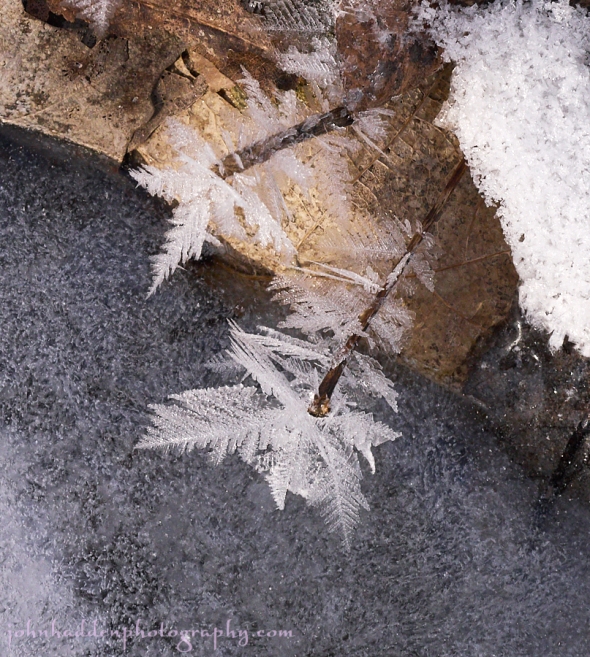
An ice encrusted tamarack twig in our front field
Morning Observation:
This morning in Huntington at 7:55AM it’s currently a blustery 32 degrees under mostly cloudy skies. Winds are out of the west at 6-11 mph. Relative humidity is 72%, dewpoint 24, barometric pressure 29.40” and rising slowly. We picked up 0.06” of rain and 0.75” of snow in the past 24hrs. Yesterday’s high was 43, and the overnight low was 31.
Forecast:
A broad mid-to-upper level trough with several embedded shortwaves disturbances will continue to affect the region through this weekend. Aided by a prevailing moist westerly flow from the Great Lakes, periods of snow shower activity will continue, most frequent across the higher terrain of the northern ‘Dacks and northern Greens. Only minimal snow accumulations are expected in valley locations, but several inches may fall in favored upslope flow locations. Temperatures will trend cooler, but will remain somewhat above average for late January.
We’ll see cloudy skies today with a 50% chance of snow showers. Highs will be in the lower 30s with west winds 15 to 20 mph gusting up to 30 mph. Tonight snow showers are likely mainly until midnight. We could see total snow accumulations of 3″ to 5″. Lows will be in the mid 20s with west winds 15 to 20 mph. Chance of snow is 70%.
Saturday should be cloudy with a 50% chance of snow showers. Highs will be in the upper 20s with west winds 10 to 15 mph. Saturday night should be cloudy with a 50% chance of snow showers. Lows will be in the lower 20s with southwest winds around 10 mph.
Sunday’s looking mostly cloudy with a 50% chance of snow showers. Highs will be in the upper 20s with west winds around 10 mph. Sunday night should be partly cloudy with lows around 10 above.
Almanac:
Last year on this date we had a high of 37 and a low of 13. We picked up 0.01″ of rain and had 2.5″ at the stake.
Burlington averages for this date are highs of 27 and lows of 10.
The record high was 53°F in 1996.
The record low was -29°F in 1994.
Sky Notes:
Sunrise: 7:15 AM EST
Sunset: 4:54 PM EST
Length of Visible Light: 10h 42m
Length of Day: 9h 39m
Tomorrow will be 2m23s longer.
The Moon is new, 28.9 days old with 0.5% illumination.
Moonrise: 6:47 AM EST
Moonset: 4:50 PM EST
About Today’s Photo:
The tamarack in our front field had a nice, decorative layer of ice on it the other day after the freezing rain. All that ice is gone now after yesterday’s warming.
Panasonic GX8, Olympus 60mm macro lens, ISO 800, f/7.1, 1/500″ exposure.
Thursday, January 26, 2017

A layer of ice on elm buds in our front field
Morning Observation:
This morning in Huntington at 7:50AM it’s currently 36 degrees under cloudy skies. Winds are out of the south at 0-3 mph. Relative humidity is 97%, dewpoint 36, barometric pressure 29.32” and falling. We have 2.5” of snow at the stake. Yesterday’s high was 33, and the overnight low was 33.
Forecast:
We’ll be under the influence of a broad mid-level trough with several embedded shortwave troughs that will bring chances for daily precipitation into early next week. With the colder air filtering in, temperatures will trend cooler, but remain above normal for late January. Scattered snow showers will be likely in the higher terrain with decent accumulations across the mountains, but only minimal snow accumulations are expected in valley locations through Sunday.
We’ll see cloudy skies today with a chance of rain showers this morning then snow showers likely mainly this afternoon. We could see snow accumulations of a dusting to 1″. Highs will be in the lower 40s with southwest winds 10 to 15 mph. Chance of precipitation is 70%. Tonight should be cloudy with snow or rain showers likely until midnight, then a chance of snow showers after midnight. We could see snow accumulations of a dusting to 2″. Lows will be in the mid 20s with west winds 15 to 20 mph gusting up to 30 mph. Chance of precipitation is 70%.
Friday snow showers are likely mainly in the afternoon with additional snow accumulation of a dusting to 2″ possible. Highs will be around 30 with west winds 15 to 20 mph gusting up to 30 mph. Chance of snow is 70%. Friday night snow showers are likely with additional light snow accumulations possible. Lows will be in the mid 20s with west winds 10 to 15 mph gusting up to 25 mph. Chance of snow is 70%.
Saturday’s looking cloudy with a 50% chance of snow showers. Highs will be in the upper 20s with west winds 10 to 15 mph. Saturday night snow showers are likely with light snow accumulations possible. Lows will be in the lower 20s. Chance of snow is 70%.
Almanac:
Last year on this date we had a high of 44 and a low of 32. We had 5″ of snow at the stake.
Burlington averages for this date are highs of 27 and lows of 10.
The record high was 55°F in 1950.
The record low was -25°F in 1994.
Sky Notes:
Sunrise: 7:16 AM EST
Sunset: 4:53 PM EST
Length of Visible Light: 10h 40m
Length of Day: 9h 37m
Tomorrow will be 2m19s longer.
The Moon is a waning crescent, 28 days old with 3% illumination.
Moonrise: 6:03 AM EST
Moonset: 3:51 PM EST
About Today’s Photo:
The icing conditions of the other day created a decent layer of ice on twigs and branches. These elm buds in our front field had a pretty good coating.
Panasonic GX8, Olympus 60mm macro lens, ISO 800, f/8, 1/320″ exposure.
Wednesday, January 25, 2017


A pair of mourning doves resting above Fargo Brook
Morning Observation:
This morning in Huntington at 7:55AM it’s currently 27 degrees under overcast skies. Winds are calm. Relative humidity is 94%, dewpoint 25, barometric pressure 29.58” and rising. We picked up a 1.30” layer cake of frozen sleet, snow, a thin créme brûlée crust of ice, and a dusting of powder on top. We have 2.75” at the stake. Yesterday’s high was 34, and the overnight low was 26.
Forecast:
Low pressure over the Gulf of Maine this morning will move northeast into the Canadian Maritimes later today. An upper level trough will move east from the Great Lakes late tonight and Thursday bringing a chance for rain and snow showers to the region late tonight and Thursday. Cyclonic flow aloft will deliver colder air and a chance of snow showers from Friday through this weekend, though temperatures will remain 6-8 degrees above seasonal averages.
We’ll see cloudy skies with a 20% chance of snow showers this morning. Highs will be in the mid 30s with northwest winds around 10 mph. Tonight should be cloudy with a 20% chance of snow showers after midnight. Temperatures will remain near steady at around 30 with light and variable winds, becoming southerly around 10 mph after midnight.
Thursday should be cloudy with snow showers early possibly mixing with rain in the afternoon. We may see snow accumulations of a dusting to 2″. Highs will be in the upper 30s with southwest winds around 10 mph. Chance of precipitation is 70%. Thursday night snow showers are likely with additional light snow accumulations possible. Lows will be in the upper 20s with west winds 10 to 15 mph gusting up to 30 mph. Chance of snow is 70%.
Friday’s looking mostly cloudy with a 50% chance of snow showers. Highs will be in the lower 30s with west winds 10 to 15 mph gusting up to 35 mph. Friday night should be cloudy with a 50% chance of snow showers. Lows will be in the lower 20s.
Almanac:
Last year on this date we had a high of 37 and a low of 9. We picked up 0.50″ of snow and had 5″ at the stake.
Burlington averages for this date are highs of 27 and lows of 10.
The record high was 55°F in 1938.
The record low was -19°F in 1912.
Sky Notes:
Sunrise: 7:17 AM EST
Sunset: 4:52 PM EST
Length of Visible Light: 10h 38m
Length of Day: 9h 35m
Tomorrow will be 2m19s longer.
The Moon is a waning crescent, 27 days old with 7% illumination.
Moonrise: 5:15 AM EST
Moonset: 2:57 PM EST
About Today’s Photo:
We’ve been seeing a pretty good herd of mourning doves from time to time here at our feeder. As many as 15 will show up at a time to browse below the feeders and then fly off in a whistling whir of wings when startled. These two (along with a few others) were perched in a poplar above Fargo Brook.
Panasonic GX8, Lumix 100-300mm lens @ 300mm, ISO 1600, f/5.6, 1/500″ exposure.
Tuesday, January 24, 2017


Delicate moss spore capsules above the snow
Morning Observation:
This morning in Huntington at 7:40AM it’s currently 34 degrees and snowing/sleeting lightly under overcast skies. Winds are out of the west at 1-4 mph. Relative humidity is 95%, dewpoint 32, barometric pressure 29.63” and falling rapidly. We picked up 0.47” of rain and 1” of sleet. We have 1” of sleet at the stake. Yesterday’s high was 37, and the overnight low was 30.
A Winter Weather Advisory remains in effect until 10 PM EST this evening.
Forecast:
Low pressure developing off the mid Atlantic coast this morning will move northeastward and be near Cape Cod early tonight and continue into the Canadian
Maritimes on Wednesday. The low will bring freezing rain, sleet, and some snow to the region today and tonight with some lingering precipitation Wednesday morning. Another low will move in from the Ohio River valley Thursday bringing another round of mixed precipitation. Temperatures will remain stubbornly above seasonal averages into the weekend.
We’ll see sleet, rain and freezing rain this morning with mostly rain this afternoon. Ice accumulations of up to 1/4″ are possible. Highs will be in the lower 30s with north winds around 10 mph. Chance of precipitation is near 100%. Tonight rain, freezing rain, and sleet are likely until midnight, then a chance of sleet or snow after midnight. Expect little or no snow and sleet accumulation. Temperatures will remain near steady temperature at around 30 with north winds around 10 mph. Chance of precipitation is 70%.
Wednesday should be cloudy with a 30% chance of snow in the morning. Highs will be in the mid 30s with northwest winds around 10 mph. Wednesday night should be mostly cloudy with a 50% chance of rain or snow or sleet. Temperatures will remain near steady temperature at around 30 with south winds around 10 mph.
Thursday should be cloudy with a 50% chance of rain or snow or sleet. Highs will be in the upper 30s with southwest winds around 10 mph. Thursday night should be cloudy with a 50% chance of snow showers. Lows will be in the mid 20s.
Almanac:
Last year on this date we had a high of 23 and a low of -6. We had 5″ of snow at the stake.
Burlington averages for this date are highs of 27 and lows of 10.
The record high was 52°F in 1999 (we had a high of 57).
The record low was -22°F in 1948.
Sky Notes:
Sunrise: 7:17 AM EST
Sunset: 4:50 PM EST
Length of Visible Light: 10h 35m
Length of Day: 9h 32m
Tomorrow will be 2m15s longer.
The Moon is a waning crescent, 26 days old with 13% illumination.
Moonrise: 4:24 AM EST
Moonset: 2:09 PM EST
About Today’s Photo:
These delicate moss spore capsules caught my eye as they poked above the crusty snow along Fargo Brook.
Monday, January 23, 2017

Tawny mosses beneath the snow
Morning Observation:
This morning in Huntington at 7:50AM it’s currently 34 degrees under mostly cloudy skies. Winds are out of the south at 3-5 mph. Relative humidity is 78%, dewpoint 28, barometric pressure 30.04” and rising slowly. Yesterday’s high was 37, and the overnight low was 34.
There is a Winter Weather Advisory in effect from 7:00PM this evening to 10:00PM EST Tuesday.
Forecast:
Active and snowy weather on the horizon! Low pressure will develop along the mid Atlantic coast today and move slowly northeastward and be just south of Cape Cod by early Tuesday night bringing snow, sleet, and some freezing rain to the region late tonight and Tuesday. Another low will move through the region Wednesday bringing a chance of more mixed precipitation.
We’ll see cloudy skies today with highs in the mid 30s and southeast winds 10 to 15 mph. Tonight should be cloudy with snow arriving after midnight for our area. Snow accumulations could be on the order of 2″ to 4″ by daybreak. Lows will be in the upper 20s with east winds around 10 mph, becoming northeasterly after midnight. Chance of snow is 90%.
Tuesday snow is likely with additional snow accumulations of 3″ to 5″ possible. Highs will be in the lower 30s with north winds around 10 mph. Chance of snow is near 100%. Tuesday night snow is likely with additional light snow accumulation possible. Lows will be in the mid 20s with light and variable winds. Chance of snow is 70%.
Wednesday’s looking mostly cloudy with highs in the mid 30s and southwest winds around 10 mph. Wednesday night should be cloudy with a 50% chance of snow or rain showers. Lows will be in the lower 30s.
Almanac:
Last year on this date we had a high of 20 and a low of -4. We had 5″ of snow at the stake.
Burlington averages for this date are highs of 27 and lows of 10.
The record high was 64°F in 1906.
The record low was -19°F in 1970.
Sky Notes:
Sunrise: 7:18 AM EST
Sunset: 4:49 PM EST
Length of Visible Light: 10h 33m
Length of Day: 9h 30m
Tomorrow will be 2m13s longer.
The Moon is a waning crescent, 25 days old with 20% illumination.
Moonrise: 3:29 AM EST
Moonset: 1:26 PM EST
About Today’s Photo:
Tawny sphagnum mosses add a splash of muted color in shallow snow along Fargo Brook.
Panasonic GX8, Lumix 14-140mm lens @ 28mm, ISO 800, f/13, 1/30″ exposure.
Sunday, January 22, 2017


The crowd yesterday at the Vermont Statehouse
Morning Observation:
This morning in Huntington at 8:10AM it’s currently 36 degrees under low, foggy overcast skies. Winds are calm. Relative humidity is 97%, dewpoint 35, barometric pressure 29.82” and rising slowly. We picked up a trace of rain overnight. Yesterday’s high was 43, and the overnight low was 35.
Forecast:
Though a weak ridge of high pressure is currently over the region, though a temperature inversion will continue to deliver cloudy skies today and into tomorrow. Low pressure developing along the mid Atlantic coast on Monday will move slowly northeast to around Cape Cod by early Tuesday night bringing mixed
precipitation to the region Monday night and Tuesday, with rain, sleet, snow, and freezing rain possible. We may see some workable snow accumulation here in Huntington, and there may be a decent dump of dense, wet snow in the mountains. I’ll believe it when I’m skiing it… Another low will move through Wednesday with the possibility of more mixed precip. Temperatures will continue to remain above seasonal averages clear through to next weekend.
We’ll see areas of fog this morning. It’ll be cloudy with a 20% chance of very light drizzle or light rain. Highs will be around 40 with light and variable winds. Tonight should be cloudy with a slight chance of light snow or light rain. Lows will be in the upper 20s with light and variable winds, becoming southeasterly around 10 mph after midnight. Chance of precipitation is 20%.
Monday should be cloudy with highs in the mid 30s and southeast winds 10 to 15 mph. Monday night will bring snow or sleet with light snow accumulations possible. Lows will be in the upper 20s with e4ast winds 10 to 15 mph. Chance of precipitation is 90%.
Tuesday sleet, rain, or snow are likely with additional light snow accumulations possible. Highs will be in the mid 30s with northeast winds around 10 mph. Chance of precipitation is 70%. Tuesday night sleet or snow showers are likely with additional light snow accumulations possible. Lows will be in the mid 20s. Chance of precipitation is 70%.
Almanac:
Last year on this date we had a high of 27 and a low of 1. We had 5.25″ of snow at the stake.
Burlington averages for this date are highs of 27 and lows of 10.
The record high was 59°F in 1906.
The record low was -22°F in 1970.
Sky Notes:
Sunrise: 7:19 AM EST
Sunset: 4:48 PM EST
Length of Visible Light: 10h 31m
Length of Day: 9h 28m
Tomorrow will be 2m10s longer.
The Moon is a waning crescent, 24 days old with 28% illumination.
Moonrise: 2:33 AM EST
Moonset: 12:48 PM EST
About Today’s Photo:
I know I usually post photos of the natural world here on this blog, but, as humans are part of nature, and as yesterday’s marches around the globe were something to celebrate, I thought I share a shot from Vermont’s state capital in Montpelier yesterday. Estimates of 7000 people showing up were a bit on the low side as now they’re saying between 10,000 and 20,000 people rallied at the Statehouse for Women’s (and all Human) rights. Go people! It was a beautiful thing!
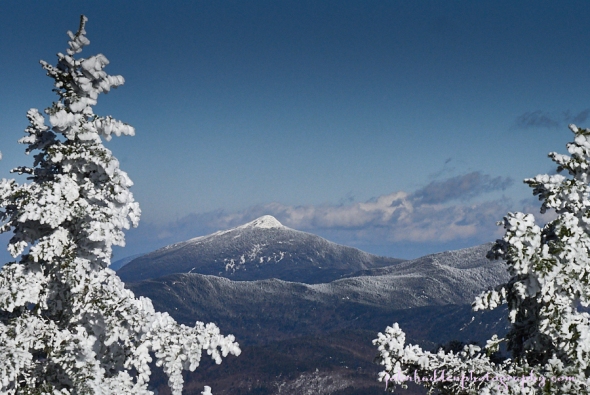
Saturday, January 21, 2017
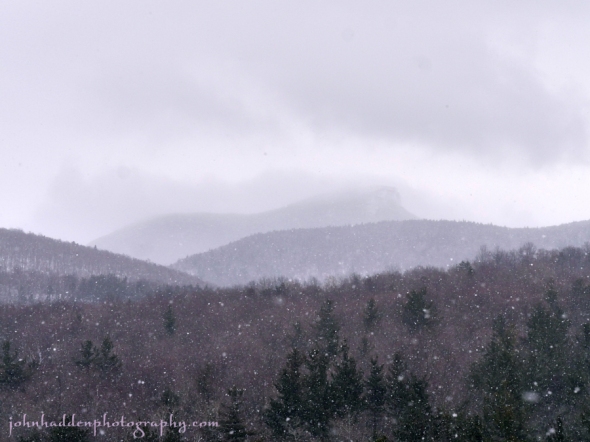
Camel’s Hump shrouded in clouds the other afternoon
Morning Observation:
This morning in Huntington at 7:55AM it’s currently 35 degrees and drizzling lightly under overcast skies. Winds are calm. Relative humidity is 96%, dewpoint 34, barometric pressure 29.80”. We picked up a 0.01” trace of rain overnight. Yesterday’s high was 39, and the overnight low was 35.
Forecast:
Cloudy yet unseasonably mild weather will continue for the region this weekend. A weak disturbance moving across the eastern Great Lakes this morning will skirt the prevailing ridge of high pressure over the region and provide just a chance of a few light rain showers and patchy drizzle today into tonight. The start of the work week brings a more active period of weather as a moisture laden system move slowly northeastward from the Gulf Coast states to bring a wintry mix to the along with the potential for strong and gusty winds, especially along the western slopes of the Greens.
We’ll see a 20% chance of rain this morning. It’ll be cloudy with highs in the lower 40s and light and variable winds. Tonight should be cloudy with a slight chance of drizzle until midnight. Lows will be in the lower 30s with light and variable winds.
Sunday should be cloudy with a 20% chance of rain showers in the afternoon. Highs will be around 40 with light and variable winds. Sunday night should be cloudy with lows in the upper 20s and east winds around 10 mph.
Monday should be cloudy with a 50% chance of rain or freezing rain by mid-day. Highs will be in the mid 30s with southeast winds 15 to 20 mph gusting up to 30 mph. Monday night snow or sleet are likely with light snow accumulations possible. Lows will be in the upper 20s. Chance of precipitation is 80%.
Almanac:
Last year on this date we had a high of 20 and a low of 2. We picked up 0.25″ of new snow and had 6″ at the stake.
Burlington averages for this date are highs of 27 and lows of 10.
The record high was 54°F in 2006 (we had a high of 58).
The record low was -15°F in 1971.
Sky Notes:
Sunrise: 7:20 AM EST
Sunset: 4:46 PM EST
Length of Visible Light: 10h 29m
Length of Day: 9h 26m
Tomorrow will be 2m8s longer.
The Moon is a waning crescent, 23.4 days old with 37% illumination.
Moonrise: 1:36 AM EST
Moonset: 12:14 PM EST
About Today’s Photo:
The scattered snow flurries of the other day produced a moody setting for Camel’s Hump in this view from our neighbor’s field.
Panasonic GX8, Lumix 14-140mm lens @ 81mm, ISO 800, f/13, 1/250″ exposure.
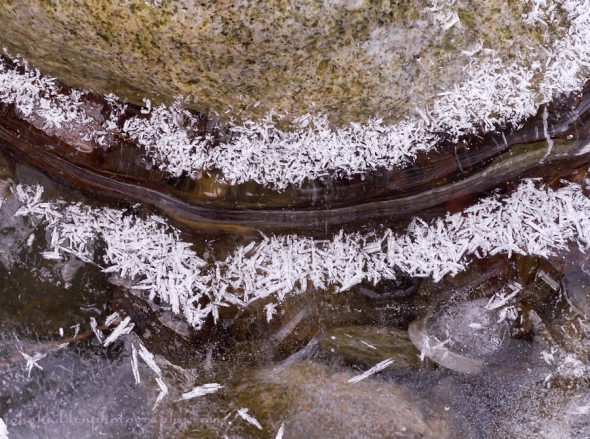
Friday, January 20, 2017

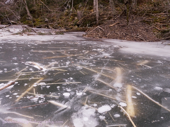
Positive and negative space in Fargo Brook
Morning Observation:
This morning in Huntington at 7:40AM it’s currently 32 degrees under mostly cloudy skies. Winds are calm. Relative humidity is 87%, dewpoint 29, barometric pressure 29.98”. We’re pretty much down to bare ground at the snow stake. Yesterday’s high was 38, and the overnight low was 32.
Forecast:
A ridge of high pressure over the region this morning will deliver relatively quiet weather through the upcoming weekend with mainly cloudy skies and very mild temperatures. A more significant weather maker is looking more likely to affect the region Monday night into Tuesday with potential significant accumulations of snow or mixed precipitation. Stay tuned!
We’ll see cloudy this morning giving way to partly sunny skies this afternoon. Highs in the upper 30s with light and variable winds. Tonight should be partly cloudy until midnight, then become mostly cloudy with lows in the lower 30s and south winds around 10 mph.
Saturday should be cloudy with a slight chance of light rain or very light freezing drizzle in the morning, then a chance of very light drizzle or light rain in the afternoon. Highs will be in the upper 30s with light and variable winds. Chance of precipitation is 30%. Saturday night should be cloudy with lows in the upper 20s and light and variable winds.
Sunday’s looking cloudy with highs in the upper 30s and north winds around 10 mph. Sunday night should be mostly cloudy with lows in the mid 20s.
Almanac:
Last year on this date we had a high of 23 and a low of 2. We picked up 5.5″ of new snow and had 7″ at the stake (the deepest snowpack we had of the 2015-2016 season).
Burlington averages for this date are highs of 27 and lows of 10.
The record high was 52°F in 1951.
The record low was -22°F in 1970.
Sky Notes:
Sunrise: 7:21 AM EST
Sunset: 4:45 PM EST
Length of Visible Light: 10h 28m
Length of Day: 9h 24m
Tomorrow will be 2m4s longer.
The Moon is a waning crescent, 22.5 days old with 46% illumination.
Moonrise: 12:38 AM EST
Moonset: 11:43 AM EST
About Today’s Photo:
Snow, ice, and water create positive and negative space in Fargo Brook.
Panasonic GX8, Lumix 14-140mm lens @ 46mm, ISO 800, f/10, 1/160″ exposure.
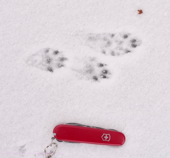
Thursday, January 19, 2017


Mink tracks in fresh snow beside Fargo Brook yesterday
Morning Observation:
This morning in Huntington at 8:00AM it’s currently 33 degrees under overcast skies. Winds are calm. Relative humidity is 97%, dewpoint 32, barometric pressure 29.98” and rising. We had off-and-on flurries during much of the day yesterday, but only picked up 0.03” of melted precipitation to show for it. We have 1” of snow at the stake. Yesterday’s high was 38, and the overnight low was 33.
Forecast:
Surface high pressure and an a ridge aloft will build into the region today. Any areas of morning drizzle should dissipate through the day, but a developing low level inversion will keep skies cloudy right through Friday and into the weekend along with above normal temperatures.
We’ll see cloudy skies with a slight chance of drizzle along with a chance of freezing drizzle mainly this morning. Highs will be in the mid 30s with west winds around 10 mph, becoming northwesterly this afternoon. Tonight should b cloudy with lows in the upper 20s and light and variable winds.
Friday should be mostly cloudy in the morning, then become partly sunny. Highs will be in the upper 30s with light and variable winds, becoming southerly around 10 mph in the afternoon. Friday night should be partly cloudy with lows around 30 and south winds around 10 mph.
Saturday should be cloudy and mild with highs around 40 and light and variable winds. Saturday night should be cloudy with lows in the lower 30s.
Almanac:
Last year on this date we had a high of 14 and a low of 5. We had 2.75″ of snow at the stake.
Burlington averages for this date are highs of 27 and lows of 10.
The record high was 65°F in 1996.
The record low was -24°F in 1976.
Sky Notes:
Sunrise: 7:21 AM EST
Sunset: 4:44 PM EST
Length of Visible Light: 10h 26m
Length of Day: 9h 22m
Tomorrow will be 2m2s longer.
The Moon is in its last quarter, 21.6 days old with 55% illumination.
No Moon Rise
Moonset: 11:14 AM EST
About Today’s Photo:
Yesterday’s fresh snowfall (meager as it was…) was an invitation to get outside and do a little tracking. As usual, I headed to Fargo Brook first to see what I could find. I wasn’t disappointed as I came across a set of mink tracks a hundred feet or so downstream from our back yard. I followed the tracks quite a ways downstream “watching” as the mink bounded along the edge of the open water, paused here and there, dove under the ice to hunt, and then pop back up farther downstream to leave more prints. It was fun to see how the critter spent his morning! The photo above shows him bounding quite fast along the ice while the photo below shows the tracks up close with my trusty Swiss Army knife for scale.
Wednesday, January 18, 2017

A nice set of red fox tracks in Fargo Brook
Morning Observation:
This morning in Huntington at 8:15AM it’s currently 35 degrees and snowing lightly under overcast skies. Winds are out of the south at 3-6 mph. Relative humidity is 75%, dewpoint 27, barometric pressure 29.96 and rising slowly. We picked up 0.75” of heavy sleety snow overnight and have 1.5” at the stake. Yesterday’s high was 40, and the overnight low was 34.
A Winter Weather Advisory remains in effect until 1:00PM EST this afternoon.
Forecast:
The low that delivered last night’s precipitation is moving to the east this morning while another low south of Long Island early this morning will move slowly eastward south of New England today keeping us cloudy with some lingering precipitation possible. High pressure will build in Thursday and dominate the weather for the upcoming weekend. Temperatures will remain well above seasonal averages for the period.
We’ll see cloudy skies today with a 50% chance of snow or rain. Highs will be in the mid 30s with southeast winds 10 to 15 mph. Tonight should be cloudy with a 40% chance of snow or rain mainly until midnight. Temperatures will remain near steady in the lower 30s with south winds around 10 mph.
Thursday should be cloudy with a slight chance of freezing drizzle in the morning. Highs will be in the upper 30s with light and variable winds. Thursday night should be cloudy with lows in the upper 20s and light and variable winds.
Friday should be mostly cloudy with highs in the upper 30s and light and variable winds. Friday night should be partly cloudy with lows in the upper 20s.
Almanac:
Last year on this date we had a high of 25 and a low of 9. We picked up 3″ of new snow and had 3.5″ at the stake.
Burlington averages for this date are highs of 27 and lows of 10.
The record high was 53°F in 1996.
The record low was -24°F in 1974.
Sky Notes:
Sunrise: 7:22 AM EST
Sunset: 4:42 PM EST
Length of Visible Light: 10h 24m
Length of Day: 9h 20m
Tomorrow will be 1m59s longer.
The Moon is waning gibbous, 20.7 days old with 65% illumination.
Moonrise: 11:39 PM EST
Moonset: 10:46 AM EST
About Today’s Photo:
Fresh snow (remember that?) offers a great opportunity to see who’s been doing what outside. Streams like Fargo Brook are natural corridors for animal travel, and I’ll often find quite a few tracks of different species nearby. This set of red fox tracks was just about perfect. The fox seemed to be walking carefully placing its hind paws directly in its front prints (called direct registering) as it traveled along the ice upstream. A pair of squirrel prints are at the lower right of the image.
Panasonic GX8, Olympus 60mm macro lens, ISO 800, f/13, 1/160″ exposure.
Tuesday, January 17, 2017

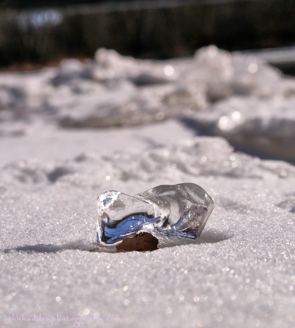
A small chunk of clear ice perched on a stone along the Winooski River
Morning Observation:
This morning in Huntington at 8:00AM it’s currently 17 degrees under mostly clear skies. Winds are calm. Relative humidity is 92%, dewpoint 15, barometric pressure 30.27” and rising slowly. We have a 0.25” dusting of snow at the stake but the ground is mostly bare. Yesterday’s high was 37, and the overnight low was 16.
There’s a Winter Weather Advisory in effect for our region from 4:00PM this afternoon to 1:00PM EST Wednesday.
Forecast:
Low pressure will move northeast through the eastern Great Lakes today and up the St. Lawrence Valley tonight and Wednesday. A mix of wintry precipitation will begin in northern New York late today, and spread eastward across Vermont overnight, and continue area-wide through Wednesday. East central Vermont should be the big winner getting 4″-6″ while the Champlain Valley may see only an inch or two. High pressure will build in late Thursday bringing dry and unseasonably warm weather through the weekend.
We’ll see partly sunny skies today with a 50% chance of snow and sleet this afternoon. Highs will be in the mid 30s with light and variable winds, becoming southeasterly around 10 mph this afternoon. Tonight snow and sleet are likely with accumulations of 2″ to 4″. Temperatures will remain near steady at around 30 with southeast winds 15 to 20 mph gusting up to 30 mph. Chance of precipitation is near 100%.
Wednesday should be cloudy with snow likely mainly in the morning. Total snow accumulations of 3″ to 5″ are possible and it’ll be the heavy dense stuff. Highs will be in the mid 30s with southeast winds 10 to 15 mph. Chance of snow is 70%. Wednesday night should be cloudy with a 40% chance of snow showers. Temperatures will be near steady in the lower 30s with south winds around 10 mph.
Thursday’s looking cloudy with a 30% chance of rain or snow showers. Highs will be around 40 with light and variable winds. Thursday night should be mostly cloudy with lows in the upper 20s.
Almanac:
Last year on this date we had a high of 30 and a low of 20. We picked up 0.18″ of rain and had 1″ of snow at the stake.
Burlington averages for this date are highs of 27 and lows of 10.
The record high was 56°F in 1889.
The record low was -22°F in 1974.
Sky Notes:
Sunrise: 7:23 AM EST
Sunset: 4:41 PM EST
Length of Visible Light: 10h 22m
Length of Day: 9h 18m
Tomorrow will be 1m55s longer.
The Moon is waning gibbous, 19.8 days old with 74% illumination.
Moonrise: 10:39 PM EST
Moonset: 10:18 AM EST
About Today’s Photo:
I took a stroll along the banks of the Winooski River in Richmond yesterday. This small chunk (mayber and inch or two long) of clear ice caught my eye as it glistened in the midday sun. It wasn’t until I looked at it on my computer that I saw that the ice was perched on small stone!
Panasonic GX8, Lumix 14-140mm lens @ 32mm, circular polarizing filter, ISO 800, f/6.3, 1/5000″ exposure.
Monday, January 16, 2017
Stockpiled food under the ice by the beaver lodge on Gillette Pond
Morning Observation:
This morning in Huntington at 7:50AM it’s currently 18 degrees under clear skies. Winds are calm. Relative humidity is 89%, dewpoint 15, barometric pressure 30.38” and just starting to drop. We picked up 1” of fluffy snow yesterday during the morning and have about 0.5” at the stake this morning. Yesterday’s high was 24, and the overnight low was 8.
Forecast:
High pressure over the region this morning will deliver mostly sunny skies today and into Tuesday. Low pressure moving out of the Ohio River valley Tuesday will set the stage for another round of mixed precipitation Tuesday night into Wednesday. Dry and unseasonably be warm condition are on tap for the remainder of the work week.
We’ll see sunny skies today with highs in the lower 30s and southwest winds around 10 mph. Tonight should be clear until midnight, then becoming partly cloudy. Lows will be around 20 with southwest winds around 10 mph until midnight, becoming light and variable.
Tuesday should be partly sunny with a chance of rain or snow in the afternoon as the aforementioned low approaches. Highs will be in the mid 30s with light and variable winds, becoming southeasterly around 10 mph in the afternoon. Chance of precipitation is 50%. Tuesday night snow or rain likely with some light snow accumulation possible. Lows will be in the upper 20s with southeast winds 10 to 15 mph gusting up to 25 mph. Chance of precipitation is 90%.
Wednesday snow transitioning to rain is likely. Highs will be in the upper 30s with southeast winds around 10 mph. Chance of precipitation is 90%. Wednesday night should be cloudy with a 50% chance of snow or rain showers. Lows will be around 30.
Almanac:
Last year on this date we had a high of 37 and a low of 22. We had 1.5″ of snow at the stake.
Burlington averages for this date are highs of 27 and lows of 10.
The record high was 63°F in 1995.
The record low was -21°F in 2009 (we had a low of -20).
Sky Notes:
Sunrise: 7:23 AM EST
Sunset: 4:40 PM EST
Length of Visible Light: 10h 20m
Length of Day: 9h 16m
Tomorrow will be 1m52s longer.
The Moon is waning gibbous, 18.8 days old with 82% illumination.
Moonrise: 9:37 PM EST
Moonset: 9:49 AM EST
About Today’s Photo:
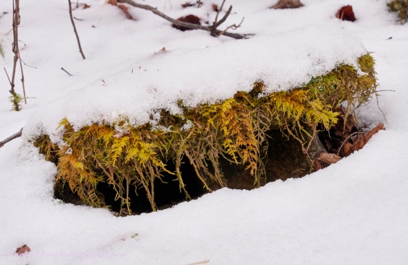
There’s an active beaver lodge on the eastern shore of Gillette pond about halfway down the main arm. In the fall, beavers will stockpile branches and twigs near their lodge to get them through the winter. The stockpile was plain to see through the clear ice the other day.
Panasonic GX8, Lumix 14-140mm lens @14mm, ISO 800, f/10, 1/200″ exposure.
Sunday, January 15, 2017


Rocks and ice at Gillette Pond yesterday
Morning Observation:
This morning in Huntington at 8:25AM it’s currently 23 degrees and snowing lightly under overcast skies. Winds are calm. Relative humidity is 82%, dewpoint 19, barometric pressure 30.33” and rising slowly. We’ve picked up a 0.25” dusting of snow. Just that quarter inch at the stake. Yesterday’s high was 23, and the overnight low was 23.
Forecast:
An upper level disturbance will move across the area this morning bringing light snow to the northern ‘Dack York and the northern half of Vermont. Expect just a dusting. High pressure will build into the region from Canada this afternoon and remain over the area through Monday bringing drier weather and a warming trend into the middle of next week.
We’ll see cloudy skies with light snow likely this morning, then partly sunny skies this afternoon. Snow accumulation should be a dusting to 1″. Highs will be in the lower 20s with northwest winds 10 to 15 mph. Chance of snow is 70%. Tonight shoud be partly cloudy until midnight, then clearing. Lows will be around 11 with light and variable winds.
Monday should be sunny with highs in the lower 30s and southwest winds around 10 mph. Monday night should be partly cloudy with lows around 18 and southwest winds around 10 mph.
Tuesday’s looking partly sunny and seasonably mild with highs in the upper 30s and southeast winds around 10 mph. Another low pressure system moving out of the Ohio River Valley will approach Tuesday night bringing snow, sleet, or a chance of rain. Light snow accumulations are possible. Lows will be in the upper 20s. Chance of precipitation is 70%.
Almanac:
Last year on this date we had a high of 31 and a low of 9. We had 2.25″ of snow at the stake.
Burlington averages for this date are highs of 27 and lows of 10.
The record high was 66°F in 1995.
The record low was -30°F in 1957.
Sky Notes:
Sunrise: 7:24 AM EST
Sunset: 4:39 PM EST
Length of Visible Light: 10h 19m
Length of Day: 9h 14m
Tomorrow will be 1m50s longer.
The Moon is waning gibbous, 17.8 days old with 89% illumination.
Moonrise: 8:33 PM EST
Moonset: 9:18 AM EST
About Today’s Photo:
We went for a skate on Gillette Pond yesterday. The ice was in great shape after having been “Zambonied” by the recent warm temperatures and rain and then flash frozen overnight. There’s a good 5″-6″ of clear ice across the pond and the skating was great!
Panasonic GX8, Lumix 14-140mm lens @ 14mm, ISO 800, f/14, 1/200″ exposure.
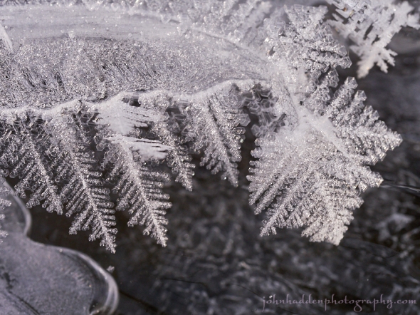
Saturday, January 14, 2017

Frost feathers bloom on leaf stems above Fargo Brook
Morning Observation:
This morning in Huntington at 8:25AM it’s currently 3 degrees under clear skies. Winds are calm. Relative humidity is 87%, dewpoint 0, barometric pressure 30.69” and falling slowly. Yesterday’s daytime high was 31 (down from 46 at midnight), and the overnight low was 3. Zilch on snow.
Forecast:
High pressure over the entire northeast today will deliver lenty of sunshine and temperatures a few degrees below seasonal averages. An upper level disturbance will drop down from Canada later tonight into the first half of Sunday bringing increasing clouds and a chance of snow showers to the northern ‘Dacks and the north central and northeast portions of Vermont. High pressure will build back into the region Sunday night into Monday bringing dry weather, then a warming trend will begin on Monday with high temperatures a few degrees above normal.
We’ll see mostly sunny skies today with highs in the lower 20s and light and variable winds. Tonight should be partly cloudy with lows around 14 and light and variable winds, becoming westerly around 10 mph after midnight.
Sunday should be mostly cloudy in the morning, then become partly sunny. Highs will be in the lower 20s with northwest winds 10 to 15 mph. Sunday night should be mostly clear with lows around 7 and light and variable winds.
Monday’s looking mostly sunny with highs in the lower 30s and southwest winds around 10 mph. Monday night should be partly cloudy with lows around 20.
Almanac:
Last year on this date we had a high of 24 and a low of 2. We had 2.25″ of snow on the ground.
Burlington averages for this date are highs of 27 and a low of 10.
The record high was 60°F in 1995.
The record low was -26°F in 1914.
Sky Notes:
Sunrise: 7:24 AM EST
Sunset: 4:37 PM EST
Length of Visible Light: 10h 17m
Length of Day: 9h 12m
Tomorrow will be 1m45s longer.
The Moon is waning gibbous, 16.8 days old with 95% illumination.
Moonrise: 7:27 PM EST
Moonset: 8:42 AM EST
About Today’s Photo:
Delicate frost feathers bloom on poplar leaf stems embedded in the snow along Fargo Brook.
Panasonic GX8, Olympus 60mm macro lens, ISO 800, f/13, 1/125″ exposure.
Friday, January 13, 2017

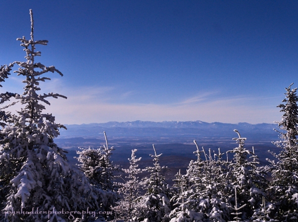
Looking west from General Stark Mtn. over the Champlain valley to the High Peaks of the Adirondacks
Morning Observation:
This morning in Huntington at 8:10AM it’s currently 31 degrees under mostly cloudy skies. Wind are out of the west at 0-4 mph. Relative humidity is 72%, dewpoint 23, barometric pressure 30.29” and rising rapidly. We picked up 0.02” of rain in the past 24hrs and have lost all our snow. Yesterday’s high was 54, and the overnight low was 31.
Forecast:
Roller coaster goes up, roller coaster goes down. Now it’s heading down. Colder air will be moving into the region today behind a cold front that moved through last night. High temperatures will top out this morning then fall throughout the day. Morning clouds and mountain snow showers will give way to clearing skies this afternoon. High pressure will build down from Canada tonight and Saturday bringing below normal temperatures to the area through the entire weekend. Time to break out the ice skates!
We’ll see mostly cloudy skies this morning with a slight chance of snow showers, then partly sunny skies this afternoon. Highs will top our around 30 then fall to around 18 this afternoon with northwest winds 15 to 20 mph gusting up to 30 mph. Tonight should be mostly clear with lows around zero and northwest winds 10 to 15 mph.
Saturday should be mostly sunny with highs around 19 and light and variable winds. Saturday night should be partly cloudy with lows around 14 and southwest winds around 10 mph.
Sunday’s looking partly sunny with highs in the lower 20s and northwest winds 10 to 15 mph. Sunday night should be mostly clear with lows around 10 above.
Almanac:
Last year on this date we had a high of 23 and a low of 1. We picked up 3.25″ of snow and had 3.25″ at the stake. Yup, more snow last year than now. Not a good sign…
Burlington averages for this date are highs of 27 and lows of 10.
The record high was 60°F in 1932.
The record low was -23°F in 1914.
Sky Notes:
Sunrise: 7:25 AM EST
Sunset: 4:36 PM EST
Length of Visible Light: 10h 16m
Length of Day: 9h 11m
Tomorrow will be 1m42s longer.
The Moon is waning gibbous, 15.7 days old with 99% illumination.
Moonrise: 6:19 PM EST (1/13)
Moonset: 8:01 AM EST (1/13)
About Today’s Photo:
Here’s another view from the top of General Stark Mtn. at the top of Mad River Glen. This time we’re looking west across the (snowless) Champlain Valley, the open waters of Lake Champlain, and to the High Peaks of the Adirondack Mountains. Mt. Marcy, the highest peak in the ‘Dacks can be seen just about in the center of the ridgeline.
Panasonic GX8, Lumix 14-140mm lens @ 28mm, ISO 800, f/13, 1/1600″ exposure.
Thursday, January 12, 2017

A fine view of Camel’s Hump yesterday from the porch of the Stark’s Nest at the top of the Mad River Glen Single Chair
Morning Observation:
This morning in Huntington at 7:50AM it’s currently 48 degrees under overcast skies. Winds are out of the south at 3-7 mph. Relative humidity is 88%, dewpoint 45, barometric pressure 29.84” and falling slowly. We picked up 0.09” of rain overnight and still have 2” of snow at the stake, though our front south-facing field is bare. Yesterday’s high was 48, and the overnight low was 40.
Forecast:
Low pressure moving out of the Ohio River valley this morning towards the northeast will pass to our north today bringing more rain today. Highs will be around 50 with south winds 15 to 20 mph. Chance of rain is 90%. They’re be a break in the rain later this morning but a cold front pushing through tonight will bring another round of showers through the region until midnight. It’ll be mostly cloudy with a chance of snow late in higher elevations. Lows will drop into the mid 20s with west winds 10 to 15 mph. Chance of precipitation is 50%.
Friday should be partly sunny with a slight chance of snow showers in the morning. High pressure will be building in bringing cooler temperatures with highs in the upper 20s falling to around 17 in the afternoon. Winds will be northwesterly at 15 to 20 mph with gusts up to 35 mph. Friday night should be mostly clear and much colder with lows around -2 below and northwest winds 10 to 15 mph gusting up to 25 mph.
Saturday’s looking mostly sunny with highs around 17 and light and variable winds. Saturday night should be partly cloudy with lows around 10 above.
Almanac:
Last year on this date we had a high of 28 and a low of 10. We picked up 0.25″ of snow and had 0.25″ at the stake.
Burlington averages for this date are highs of 27 and lows of 10.
The record high was 55°F in 1980.
The record low was -23°F in 1968.
Sky Notes:
Sunrise: 7:25 AM EST
Sunset: 4:35 PM EST
Length of Visible Light: 10h 14m
Length of Day: 9h 09m
Tomorrow will be 1m39s longer.
The Moon is the full “Wolf” moon (Northeast Native American, Medieval Wiccan), 14 days old with 100% illumination.
Moonrise: 5:11 PM EST
Moonset: 7:13 AM EST
Other names for this month’s full moon include: “Winter” (Colonial American), “Old” (English), “Quiet” (Celtic), and “Ice” (Neo-Pagan Wiccan).
About Today’s Photo:
Yesterday’s bluebird conditions made for a fine portrait of Camel’s Hump from the porch of the Stark’s Nest at the top of the Mad River Glen Single Chair.
Panasonic GX8, Lumix 14-140mm lens @ 73mm, ISO 800, f/13, 1/2000″ exposure.
Wednesday, January 11, 2017

An interesting layering of ice, frost, and stone in Fargo Brook
Morning Observation:
This morning in Huntington at 7:50AM it’s currently a blustery 41 degrees under partly cloudy skies. Winds are out of the south at 8-12 mph. Clouds are racing northward along the spine of the Greens. We picked up 0.27” of rain and a bit of icing on cold ground surfaces. Snowpack is 3” at the stake. Yesterday’s high was 39, and the overnight low was 36.
Forecast:
Strong low pressure moving well to our northwest across northern Ontario will continue to bring gusty south to southwest winds to the region this morning. Watch out for icy spots on back roads and sidewalks as there was a bit of icing overnight. Brief high pressure will deliver a dry period this afternoon and much of tonight, before another frontal system with low pressure passing to our west brings additional light to moderate rainfall Thursday into the first half of Thursday night. Temperatures today and Thursday will be well above seasonal averages, with highs generally in the 40s and overnight lows in the upper 30s. More seasonable and drier weather will return Friday and through the upcoming weekend.
We’ll see partly sunny skies today. It’ll be breezy with highs in the lower 40s and southwest winds 15 to 25 mph gusting up to 40 mph this morning. Tonight should be mostly cloudy with a 40% chance of rain after midnight. Temperature will be near steady in the upper 30s with south winds 15 to 20 mph gusting up to 30 mph.
Thursday rain is likely. Highs will be in the mid 40s with south winds 15 to 20 mph. Chance of rain is 80%. Rain will continue into Thursday night with lows in the upper 20s and west winds 10 to 15 mph. Chance of rain is 70%. Total rainfall amounts look to be around 0.30″ in the Champlain Valley to 0.50″-0.70″ over the mountains. Yuck. Some residual snow may fall in the mountains as colder air moves in behind the departing low and high pressure begins to build in.
Friday’s looking partly sunny with highs in the upper 20s with temperature falling to around 19 in the afternoon. Winds will be northwesteyl 10 to 15 mph with gusts up to 30 mph. Friday night should be mostly clear with lows around zero.
Almanac:
Last year on this date we had a high of 34 and a low of 14. We picked up 0.88″ of rain and were down to bare ground at the stake.
Burlington averages for this date are highs of 27 and lows of 10.
The record high was 56°F in 1980.
The record low was -27°F in 1968.
Sky Notes:
Sunrise: 7:26 AM EST
Sunset: 4:34 PM EST
Length of Visible Light: 10h 13m
Length of Day: 9h 08m
Tomorrow will be 1m35s longer.
The Moon is waxing gibbous, 13.5 days old with 98% illumination.
Moonrise: 4:06 PM EST
Moonset: 6:17 AM EST
About Today’s Photo:
This interesting layering of ice, frost crystals, and stone caught my eye as I was walking Fargo Brook the other day.
Panasonic GX8, Olympus 60mm macro lens, ISO 800, f/13, 1/30″ exposure.
Tuesday, January 10, 2017


Edge ice and frost crystals on Fargo Brook
Morning Observation:
This morning in Huntington at 7:45AM it’s currently 14 degrees under mostly cloudy skies. Winds are calm. Relative humidity is 82%, dewpoint 10, barometric pressure 30.53” and falling slowly. Snowpack is 3” at the stake. Yesterday’s high was 17, and the overnight low was 13.
There is a Wind Advisory in effect from 3:00 PM this afternoon to 3:00 AM EST
Wednesday.
Forecast:
Deepening low pressure over the western Great Lakes combined with departing high pressure over the Canadian Maritimes will funnel increasingly strong and gusty south winds across the region this afternoon and tonight. Wind gusts up to 60 mph are possible across the northern Champlain Valley and the northern slopes of
the ‘Dacks, with peak gusts likely occurring this evening. A warm front approaching from the Ohio River valley will bring increasing cloudiness today, with developing periods of light snow this afternoon into this evening, changing to a wintry mix tonight. Temperatures will trend well above average Wednesday and Thursday with more rain in the forecast for Thursday.
We’ll see mostly cloudy skies today with snow likely this afternoon. Snow accumulations should be around a dusting to 1″. It’ll be breezy with highs in the lower 30s and south winds 10 to 15 mph, increasing to 20 to 25 mph with gusts up to 40 mph this afternoon. Chance of snow is 60%. Tonight snow is likely changing over to rain or sleet after midnight. Expect total snow and sleet accumulations of a dusting to 2″ before the changeover. It’ll be windy with lows in the lower 30s and south winds 20 to 30 mph gusting up to 50 mph. Chance of precipitation is 70%.
Wednesday should be partly sunny with a 30% chance of rain in the morning. It’ll be breezy with highs in the lower 40s and southwest winds 20 to 25 mph gusting up to 35 mph, then diminishing to 10 to 15 mph with gusts up to 25 mph in the afternoon. Wednesday night should be mostly cloudy with a 50% chance of rain. Lows will be in the mid 30s with south winds 10 to 15 mph.
Another low pressure system will be heading our way Thursday bringing widespread rain. Highs will be in the mid 40s with south winds 10 to 15 mph. Chance of rain is 80%. Thursday night should be mostly cloudy with a 50% chance of rain. Lows will be in the upper 20s.
Almanac:
Last year on this date we had a high of 51 and a low of 37. We also had a record high for our sheltered hollow of 48mph (since eclipsed…) We had 1″ of snow at the stake.
Burlington averages for this date are highs of 27 and lows of 10.
The record high was 53°F in 2016 (we had a high of 51).
The record low was -22°F in 1968.
Sky Notes:
Sunrise: 7:26 AM EST
Sunset: 4:33 PM EST
Length of Visible Light: 10h 11m
Length of Day: 9h 06m
Tomorrow will be 1m31s longer.
The Moon is waxing gibbous, 12 days old with 93% illumination.
Moonrise: 3:06 PM EST
Moonset: 5:13 AM EST
About Today’s Photo:
Complex layers of ice and feathery crystals form above the open water of Fargo Brook.
Panasonic GX8, Olympus 60mm macro lens, ISO 800, f/8, 1/200″ exposure.
Monday, January 9, 2017

Delicate frost crystals form along Fargo Brook
Morning Observation:
This morning in Huntington at 8:10AM it’s currently -8 (minus 8) degrees under mostly clear skies. Winds are calm. Relative humidity is 85%, dewpoint -10, barometric pressure 30.65” and rising slowly. We picked up 1.25” of light snow overnight and have 4” at the stake. Yesterday’s high was 13, and the overnight low was -8.
Forecast:
Get ready for another roller coaster… High pressure currently over the region will shift east of New England by this afternoon, allowing for developing south winds across the region and the start of a moderating temperature trend. A warm front will bring periods of light snow Tuesday afternoon, followed by intermittent sleet and possible rain Tuesday night along with gusty winds. Another frontal wave passing to our west on Thursday will bring additional precipitation in the form of light to moderate rain. Temperatures Wednesday through Friday will be well above seasonal averages, with highs generally well into the 40s, and perhaps hitting 50 degrees in spots on Thursday afternoon.
We’ll see partly sunny skies this morning, becoming cloudy this afternoon. Highs will be around 18 with south winds 10 to 15 mph. Tonight should be partly cloudy with lows around 11 and south winds 10 to 15 mph gusting to 30 mph until midnight.
Tuesday should be cloudy with snow likely in the afternoon. We may see snow accumulations a dusting to 2″ inches before the changeover. Highs will be in the lower 30s with south winds 15 to 20 mph and gusting to 35 mph in the afternoon. Chance of snow is 70%. Tuesday night rain or snow or sleet are likely with additional light snow accumulation possible. Lows will be around 30 with south winds 15 to 25 mph gusting up to 35 mph. Chance of precipitation is 70%.
Wednesday’s looking partly sunny with a 30% chance of rain in the morning. Highs will be in the lower 40s with southwest winds 15 to 20 mph. Wednesday night should be mostly cloudy with a 30% chance of rain or snow. Lows will be in the mid 30s.
Almanac:
Last year on this date we had a high of 41 and a low of 35. We had 2.25″ of snow at the stake.
Burlington averages for this date are highs of 27 and lows of 10.
The record high was 57°F in 1937.
The record low was -24°F in 1968.
Sky Notes:
Sunrise: 7:26 AM EST
Sunset: 4:31 PM EST
Length of Visible Light: 10h 10m
Length of Day: 9h 05m
Tomorrow will be 1m27s longer.
The Moon is waxing gibbous, 11 days old with 86% illumination.
Moonrise: 2:13 PM EST
Moonset: 4:04 AM EST
About Today’s Photo:
Cold morning temperatures make for lovely frost crystal where the warm open waters of Fargo Brook meet the frigid air.
Panasonic GX8, Olympus 60mm macro lens, ISO 800, f/7.1, 1/160″ exposure.
Sunday, January 8, 2017

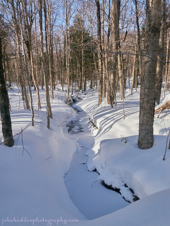
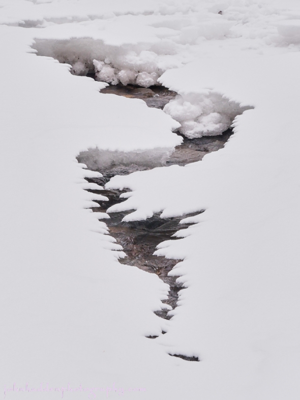
A quiet stream at Mt. Mansfield Touring Center yesterday
Morning Observation:
This morning in Huntington at 7:55AM it’s currently -1 (minus 1) degree under partly cloudy skies. Winds are calm. Relative humidity is 86%, dewpoint -4, barometric pressure 30.20”. We have 2.25” of snow at the stake. Yesterday’s high was 23, and the overnight low was -3.
Forecast:
An upper level trough will move across the region today bringing the potential for some light snow showers, especially in the higher elevations. Chilly high pressure is on tap for Monday then another low pressure system will move into the region Tuesday through Wednesday bringing snow on Tuesday before switching to a mix with some sleet then rain late Tuesday night (ugh). We’re in for a warm stretch Tuesday through Friday with temps well above seasonal averages for the season (January thaw?)
We’ll see partly sunny skies this morning, then cloudy skies with a 30% chance of snow showers this afternoon. Highs will be around 13 with light and variable winds, becoming northwesterly around 10 mph this afternoon. Tonight should be mostly cloudy with a 20% chance of snow showers until midnight, then partly cloudy after midnight. It’ll be chilly with lows around -1 below and northwest winds 10 to 15 mph.
Monday should start out partly sunny in the morning, then become cloudy. Highs will be around 18 with south winds 10 to 15 mph gusting up to 30 mph in the afternoon. Monday night should be mostly cloudy with lows around 13 and south winds 10 to 15 mph gusting up to 30 mph.
Tuesday snow showers are likely with light snow accumulations possible. Highs will be in the lower 30s with south winds 15 to 20 mph gusting up to 30 mph. Chance of snow is 60%. Tuesday night snow will transition to sleet then rain with some additional light snow accumulations possible before the change over. Lows will be steady in the lower 30s. Chance of precipitation is 90%.
Almanac:
Last year on this date we had a high of 41 and a low of 11. We had 3″ of snow at the stake.
Burlington averages for this date are highs of 27 and lows of 11.
The record high was 63°F in 2008 (we had a high of 62).
The record low was -21°F in 1968.
Sky Notes:
Sunrise: 7:27 AM EST
Sunset: 4:30 PM EST
Length of Visible Light: 10h 09m
Length of Day: 9h 03m
Tomorrow will be 1m24s longer.
The Moon is waxing gibbous, 10 days old with 77% illumination.
Moonrise: 1:26 PM EST
Moonset: 2:53 AM EST
About Today’s Photo:
We went for a ski up at the Mt. Mansfield Touring Center yesterday in Stowe. They have a good 10″ or so base in the woods and the skiing was excellent. This snow covered stream along the trail was just begging to be photographed so I obliged.
Panasonic GM5, Lumix 12-32mm lens @ 13mm, ISO 800, f/8, 1/1600″ expsoure.
