Monday, July 31, 2023

 A mud dauber wasp nest revealed
Morning Observation:
This morning in North Hero at 6:50AM it’s currently 65 degrees under partly cloudy skies. Winds are out of the southwest at 2-4 mph. Relative humidity is 80%, dewpoint 59, barometric pressure 29.86”. Yesterday’s high was 72, and yesterday’s low was 57. The overnight low got down to 63.
This morning in Huntington it’s currently 56 degrees under partly cloudy skies. Winds are calm. Relative humidity is 98%, dewpoint 55, barometric pressure 29.90”. Yesterday’s high was 76, and yesterday’s low was 55. The overnight low got down to 54.
Forecast Discussion:
After a dry start to the day, we’ll see chances for showers increasing by midday as a cold front drops through the region bringing scattered showers and afternoon thunderstorms. Any storms should be below severe levels, but brief heavy rains and frequent lightning may accompany the storms so be aware if you’re planning outdoor activities. Highs today will be below average, in the upper 60s to low 70s. High pressure will build in for the middle of the week bringing dry conditions with temperatures continuing to be 5-7 degrees below normal. Chances for showers will increase later on Thursday as low pressure skirts to our north lifting a warm from through the region Thursday afternoon/evening. Temperatures and humidity levels will begin to creep up as well as a warmer, moisture airmass moves in on a southerly airflow. We’ll see widespread showers on Friday with afternoon thunderstorms likely. At this point the weekend is looking mostly dry with the outside chance of some showers on Saturday.
3-Day Forecast:
We’ll see mostly cloudy skies today with scattered showers and thunderstorms this afternoon. Highs will be near 72 southwest winds 5-9 mph. Chance of precipitation is 60% with rainfall amounts between 0.10″-0.25″ with higher amounts possible in thunderstorms. Tonight should be mostly cloudy with scattered showers and thunderstorms before 9:00PM. Lows will be around 55 with northwest wind 5-10 mph. Chance of precipitation is 30% with rainfall amounts of less than 0.10″.
Tuesday should be mostly sunny with a high near 70 and northwest winds 5-10 mph. Tuesday night should be mostly clear with a low around 49 in Huntington and 54 in North Hero with northwest winds 5-8 mph becoming southwesterly in the evening.
Wednesday should be sunny with a high near 73 and northwest winds 3-5 mph. Wednesday night should be partly cloudy with a low around 52 in Huntington and 60 in North Hero with south winds 5-9 mph.
Almanac:
Last year on this date in Huntington we had a high of 82 and a low of 54.
Last year in North Hero we had a high of 82 and a low of 66.
Burlington averages for this date are a low of 63 and a high of 82.
The record low was 42 in 1964.
The record high was 96 in 1999 (we had a high of 92 in Huntington).
The Lake Champlain lake level in Burlington is 98.58′.
The water temperature is 72˚.
Last year’s lake level was at 94.91′.
Sky Notes:
Sunrise: 5:37AM
Sunset: 8:18PM
Length of day: 14:40:08
Today will be 2:17 shorter than yesterday.
The Moon is waxing gibbous, 13 days old with 96% illumination.
Moonrise: 8:13PM
Moonset: 3:32AM
About Today’s Photo:
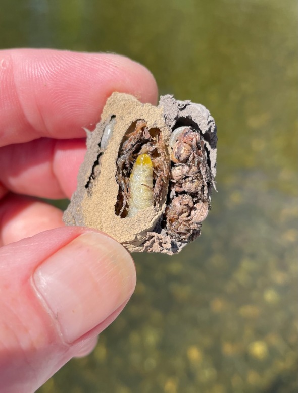
Here’s something that will interest the naturalists among you. I was opening up the bimini on our boat yesterday afternoon and came across several mud dauber wasp nests that had been made in the canvas fabric. As the name implies, these wasps build their cell-structured nests out of mud, lay an egg in each cell, and then stuff the cell with spiders that they have stunned. As the larvae grow, they eat the spiders. You can clearly see 3 cells in the photo with 3 larvae and accompanying spiders. The one in the middle has quite the head-start! Unfortunately I had to destroy this nest, but I tried to save the others that I managed to remove intact, putting them ashore in the hope that they’d hatch successfully.
iPhone 12 Pro
Sunday, July 30, 2023

 Bounteous blueberries at Grand Isle Blueberries!
Morning Observation:
This morning in North Hero at 7:10AM it’s currently 60 degrees under clear skies. Winds are calm. Relative humidity is 85%, dewpoint 56, barometric pressure 29.89”. We picked up 0.25” of rain yesterday. Yesterday’s high was 73, and yesterday’s low was 57. The overnight low got down to 57.
This morning in Huntington it’s currently 53 degrees under partly cloudy skies. Winds are calm. Relative humidity is 97%, dewpoint 52, barometric pressure 29.90”. We picked up 0.58” of rain yesterday. Yesterday’s high was 78, and yesterday’s low was 54. The overnight low got down to 52.
Forecast Discussion:
We’ve got a lovely summer day on tap for today courtesy of high pressure cresting over the region. We’ll see highs in the low to mid 70s with low humidity and light northwest winds. Low pressure over Hudson’s Bay will drop a cold front through the region later tonight and into Monday bringing some scattered showers along the international border towards dawn on Monday, spreading southward as the front progresses. High pressure is expected to move in through midweek bringing seasonably cool and dry conditions through Thursday. The weather will turn more active later in the week as approaching low pressure lifts a warm front through the region Thursday raising temperature and humidity levels. Chances for showers and thunderstorms will increase Thursday night into Friday as the aforementioned low swings a cold front through the region.
3-Day Forecast:
We’ll see most sunny skies today with a high near 73 and northwest winds 5-10 mph. Tonight should be partly cloudy with a low around 56 and southwest winds around 5-10 mph.
Monday should be mostly cloudy with scattered showers and afternoon thunderstorms. Highs will be near 72 with west winds 6-9 mph becoming northwesterly in the afternoon. Chance of precipitation is 40 with rainfall amounts of less than 0.10″ possible with higher amounts possible in thunderstorms. Monday night should be partly cloudy with a low around 50 in Huntington and 57 in North Hero with northwest winds around 6 mph.
Tuesday should be mostly sunny with a high near 71 and northwest winds 5-10 mph. Tuesday night should be mostly clear with a low around 48 in Huntington and 57 in North Hero with winds around 6 mph becoming southerly late.
Almanac:
Last year on this date in Huntington we had a high of 73 and a low of 53.
Last year in North Hero we had a high of 74 and a low of 65.
Burlington averages for this date are a low of 63 and a high of 82.
The record low was 45 in 1968.
The record high was 96 in 1959.
The Lake Champlain lake level in Burlington is 98.62′.
The water temperature is 72˚.
Last year’s lake level was at 94.94′.
Sky Notes:
Sunrise: 5:36AM
Sunset: 8:19PM
Length of day: 14:42:25
Today will be 2:14 shorter than yesterday.
The Moon is waxing gibbous, 12 days old with 91% illumination.
Moonrise: 7:21PM
Moonset: 2:22AM
About Today’s Photo:
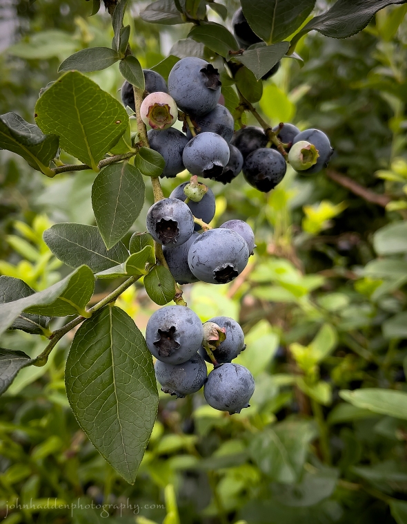
We went for a bit ‘o blueberry pickin’ yesterday with our grandson at Grand Isle Blueberries. They have a lovely setup for picking, and we made quick work of filling 4 quarts (plus the belly of a red-headed toddler…)
iPhone 12 Pro
Saturday, July 29, 2023


Morning Observation:
This morning in North Hero at 7:05AM it’s currently 66 degrees under mostly cloudy skies. Winds are out of the north at 5-7 mph. Relative humidity is 82%, dewpoint 60, bp29.86”. Yesterday’s high was 83, and yesterday’s low was 70. The overnight low got down to 66.
This morning in Huntington it’s currently 68 degrees under mostly cloudy skies. Winds are calm. Relative humidity is 97%, dewpoint 66, barometric pressure 29.85”. Yesterday’s high was 87, and yesterday’s low was 62. The overnight low got down to 67.
Forecast Discussion:
A cold front is currently dropping through the region, and surface temperatures are reflecting its passage. Indeed, in a bit of a switch, morning temperatures are cooler in North Hero than in Huntington where it’s usually 5-10 degrees cooler in the morning. The front is expected to stall during the day today allowing the remnants of decaying low pressure system to track along it bringing scattered showers and possibly a thunderstorm over southern areas this afternoon. Highs today will be a good deal cooler than yesterday with North Hero reaching the low 70s with dewpoints in the upper 40s and low 50s. As the front and low clear to the south and east respectively, much cooler air will move in bringing a refreshing night when you might actually want to have a nice blanket on! Sunday’s looking dry and seasonably cool with highs in the mid to upper 70s with low dewpoints and light northwest winds. Pretty perfect. Chances for showers will increase on Monday as low pressure and an attendant cold front approach from the Great Lakes. Dry and seasonably cool conditions are expected for midweek with the next chance of showers arriving Thursday into Friday.
3-Day Forecast:
We’ll see mostly cloudy skies today with showers and possibly a thunderstorm after 3:00PM. Highs will be near 73 with northwest winds 5-10 mph. Chance of precipitation is 80% with rainfall amounts between 0.10″-0.25″ possible with higher amounts possible in thunderstorms. Tonight should be mostly cloudy with showers likely, mainly before 9:00PM. Lows will be around 55 with north winds 6-10 mph. Chance of precipitation is 60% with rainfall amounts of less than 0.10″ possible.
Sunday should be sunny with a high near 74 and northwest winds 5-10 mph. Sunday night should be partly cloudy with a low around 57 and southwest winds 6-10 mph.
Monday should be partly sunny with a 40% chance of afternoon showers. Highs will be near 72 with northwest winds 5-10 mph. Rainfall amounts of less than 0.10″ are possible. Monday night should be partly cloudy with a low around 50 and southwest winds 5-10 mph.
Almanac:
Last year on this date in Huntington we had a high of 82 and a low of 55. We picked up 0.09″ of rain.
Last year in North Hero we had a high of 81 and a low of 69.
Burlington averages for this date are a low of 63 and a high of 82 (down a degree…)
The record low was 45 in 1987.
The record high was 98 in 1949.
The Lake Champlain lake level in Burlington is 98.63′.
The water temperature is 75˚.
Last year’s lake level was at 94.99′.
Sky Notes:
Sunrise: 5:35AM
Sunset: 8:20PM
Length of day: 14:44:40
Today will be 2:12 shorter than yesterday.
The Moon is waxing gibbous, 10.8 days old with 83% illumination.
Moonrise: 6:16PM
Moonset: 1:27AM
About Today’s Photo:
The hostas are blooming in our gardens here in North Hero. It’s something of a treat for us, as the many hostas that we’ve planted over the decades in Huntington have all fallen victim to the rapacious deer who seem to favor anything at all that we’ve planted in lieu of the many other options growing abundantly in our surrounding fields and forests!
Sony A7II, Sony 90mm macro lens, ISO 1250, f/18, 1/40″ exposure
Friday, July 28, 2023
 Rain on a window pane yesterday
Morning Observation:
This morning in Huntington at 6:30AM it’s currently 64 degrees under partly cloudy skies. Winds are calm. Relative humidity is 98%, dewpoint 98%, dewpoint 64, barometric pressure 29.96”. We picked up 0.24” of rain yesterday. Yesterday’s high was 80, and yesterday’s low was 65. The overnight low got down to 62.
This morning in North Hero it’s currently 71 degree under partly cloudy skies. Winds are out of the south at 8-12 mph. Relative humidity is 96%, dewpoint 70 barometric pressure 29.90”. We picked up 0.61” of rain yesterday. Yesterday’s high was 77, and yesterday’s low was 71. The overnight low got down to 70.
Forecast Discussion:
We’ve got a steamer on tap for today courtesy of high pressure cresting over the region. Highs today will push the upper 80s with dewpoints in the mid to upper 60s with breezy south winds. Decaying low pressure approaching from the Great Lakes will drop a cold front through the region tonight kicking off a few scattered thunderstorms along the Canadian border this evening. The front is expected to stall somewhere across the region allowing for the aforementioned low to track along it during the day Saturday bringing widespread showers during the day. The low and cold front should clear to our south and east Saturday evening bringing in a much cooler Canadian airmass that will deliver a stellar day on Sunday with clear skies, highs in the mid 70s, and dewpoints in the 50s. I’ll take it. But seeing as we can’t go more than a day or two without rain this summer, low pressure over James Bay is expected to swing some shortwave troughs across the region during the first part of the week with scattered showers and a few thunderstorms possible Monday afternoon/evening. Dry and seasonably cool conditions are expected midweek with warmer, muggier air and some showers returning by the end of the week.
3-Day Forecast:
We’ll see sunny skies today with a high near 88 and south winds 5-10 mph in Huntington and 9-17 mph over Lake Champlain. Tonight should be mostly cloudy with a 40% chance of showers and thunderstorms. Some of the storms could produce gusty winds and heavy rain. Lows will be around 63 with south winds 5-10 mph. Rainfall amounts of 0.10″-0.25″ are possible with higher amounts possible in thunderstorms.
Saturday should be cloudy with light rain and showers. Highs will be near 74 with north winds 5-7 mph. Chance of precipitation is 80% with rainfall amounts between 0.25″-0.50″ possible. Saturday night should be mostly cloudy with a 30% chance of showers before 7:00PM. Skies should gradually become mostly clear with a low around 54 in Huntington and 60 in North Hero with north winds 3-5 mph.
Sunday should be sunny with a high near 73 and northwest winds 5-7 mph. Sunday night should be partly cloudy with a low around 53 and light northwest winds.
Almanac:
Last year on this date in Huntington we had a high of 82 and a low of 57. We picked up 0.08″ of rain.
Last year in North Hero we had a high of 82 and a low of 69. We picked up 0.16″ of rain.
Burlington averages for this date are a low of 63 and a high of 83.
The record low was 45 in 2001 (We had a low of 49 in Huntington).
The record high was 96 in 1964.
The Lake Champlain lake level in Burlington is 98.61′.
The water temperature is 75˚.
Last year’s lake level was at 95.02′.
Sky Notes:
Sunrise: 5:34AM
Sunset: 8:21PM
Length of day: 14:46:53
Today will be 2:10 shorter than yesterday.
The Moon is waxing gibbous, 9.7 days old with 74% illumination.
Moonrise: 4:58PM
Moonset: 12:48AM
About Today’s Photo:
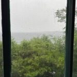
Our porch at camp faces south and east, and when the wind is blowing out of the south, it drives the rain against the windows that I can drop to keep us dry. There’s something cozy and comfortable about rain on a window pane to me…
iPhone 12 Pro
Thursday, July 27, 2023

 A stone spider prowls the beach
Morning Observation:
This morning in North Hero at 6:20AM it’s currently 72 degrees and raining under overcast skies. Winds are out of the south at 6-9 mph. Relative humidity is 92%, dewpoint 70, barometric pressure 29.82”. We picked up 0.02” of rain so far today. Yesterday’s high was 81, and yesterday’s low was 68. The overnight low got down to 70.
This morning in Huntington it’s currently 69 degrees and raining lightly under overcast skies. Winds are calm. Relative humidity is 94%, dewpoint 68, barometric pressure 29.86”. Yesterday’s high was 86, and yesterday’s low was 59. The overnight low got down to 66.
There are Flood Watches posted for our region from 7:00AM this morning until 8:00PM tonight.
Forecast Discussion:
Morning radar imagery shows low pressure over Toronto at this hour with showers lifting into the North Country along a warm front. The low is expected to weaken as it tracks through our region today and moves east of the Connecticut River valley tonight. We’ll see widespread showers with some embedded thunderstorms throughout the day today, and flood watches have been posted for our region. While the flash flood threat isn’t nearly what it has been recently, southern areas will have the best chance of some training thunderstorms, so be aware if you’re in flood prone regions. High pressure is expected to build in for Friday bringing a hot and humid day with highs in the upper 80s with some places hitting the low 90s. Dewpoints will be in the 60s as well, so it’ll be a muggy one… A cold front is expected to drop through the region sometime Friday night into Saturday. Forecast models are a bit cagey about the timing and placement of the front as it is expected to stall somewhere across New England on Saturday and act as a conduit for low pressure to ride along it bringing widespread rainfall again Friday night into Saturday. The front is expected to drop south of the region by Saturday night/Sunday morning bringing in a much more refreshing airmass with highs in the 70s expected Sunday and dewpoints in the 30s and 40s.
3-Day Forecast:
We’ll see cloudy skies today with rain and a possibly of thunderstorms. Some of the storms could produce heavy rainfall. Highs will be near 77 with south winds 7-14 mph. Chance of precipitation is 100% with rainfall amounts between b0.75”-1” possible. Tonight should gradually become mostly clear with a low around 62 and west winds 5-7 mph becoming light southerly in the evening.
Friday should be mostly sunny and hot with a high near 89 and south winds 5-8 mph in Huntington and 9-15 mph over Lake Champlain. Friday night should be mostly cloudy with a 50% chance of showers and thunderstorms. Lows will be around 63 with southwest wind 5-10 mph becoming northwest after midnight. Rainfall amounts between 0.10″-0.25″ are possible with higher amounts possible in thunderstorms.
Saturday should be mostly cloudy with showers likely, mainly before 2:00PM. Highs will be near 73 with northwest winds 6-11 mph. Chance of precipitation is 60% with rainfall amounts between 0.50”-0.75” possible. Saturday night should be partly cloudy with a 30% chance of showers before 8:00PM. Lows will be around 53 in Huntington and 59 in North Hero with northwest winds 3-6 mph.
Almanac:
Last year on this date in Huntington we had a high of 81 and a low of 51.
Last year in North Hero we had a high of 78 and a low of 66.
Burlington averages for this date are a low of 63 and a high of 83.
The record low was 46 in 2001 (We had a low of 42 in Huntington).
The record high was 98 in 1949.
The Lake Champlain lake level in Burlington is 98.64′.
The water temperature is 76˚.
Last year’s lake level was at 95.04′.
Sky Notes:
Sunrise: 5:33AM
Sunset: 8:22PM
Length of day: 14:49:04
Today will be 2:08 shorter than yesterday.
The Moon is waxing gibbous, 8.7 days old with 64% illumination.
Moonrise: 3:46PM
Moonset: 12:17AM
About Today’s Photo:
Stone spiders are common along our cobbled beach here in North Hero. These diminutive members of the wolf spider family skitter about the rocks and stones in search of small insects and invertebrates. This little guy—maybe 2cm wide—was lurking near a decomposing log that carpenter ants were mining—hence the sawdust.
Sony A7II, Sony 24-240mm lens @ 240mm, ISO 800, f/13, 1/640″ exposure
Wednesday, July 26, 2023

 Black-eyed Susans blooming
Morning Observation:
This morning in North Hero at 6:45AM it’s currently 71 degrees under mostly clear skies. Winds are out of the south at 5-8 mph. Relative humidity is 92%, dewpoint 68, barometric pressure 29.97”. We picked up 0.70” of rain last night around 11:00PM when a pretty good boomer came through. Yesterday’s high was 78, and yesterday’s low was 67. The overnight low got down to 68.
This morning in Huntington it’s currently 61 degrees under clear skies. Winds are calm. Relative humidity is 98%< dewpoint 60, barometric pressure 30.02”. Yesterday’s high was 83, and yesterday’s low was 59. The overnight low got down to 59.
Forecast Discussion:
A ridge of high pressure cresting over the region today will deliver a warm summer day with highs in the mid 80s, breezy south winds, and hazy smoke-tinted skies. Low pressure tracking out of the Great Lakes on Thursday will bring widespread showers and thunderstorms Thursdays afternoon into the evening hours. Storms may approach strong to severe levels, and we’ll have to keep an eye out for potential flash flooding as some storms may train. Showers and thunderstorms should wind down overnight with a hot and humid day expected Friday under a ridge of high pressure. Low pressure sitting over James Bay is expected to swing a cold front through the region sometime late Friday night into Saturday bringing more showers and noticeable drop in temperatures and humidity levels for the upcoming weekend. Dry and seasonably cool conditions are expected heading into early next week.
3-Day Forecast:
We’ll see mostly sunny skies today with a high near 86 and south winds 5-9 mph in Huntington and 13-17 mph in the Champlain Valley. Tonight should be partly cloudy with a low around 69 and south winds 6-9 mph in Huntington and 11-17 mph in the Champlain Valley.
Thursday should be mostly cloudy with showers and thunderstorms likely, mainly after 4:00PM. Highs will be near 82 with south winds 7-11 mph in Huntington and 11-17 mph in the Champlain Valley. Chance of precipitation is 70% with rainfall amounts between 0.75”-1” possible. Thursday night should be mostly cloudy with showers and thunderstorms until 10:00PM. Lows will be around 64 with southwest winds 7-10 mph. Chance of precipitation is 60% with rainfall amounts between 0.10″-0.25″ with higher amounts possible in thunderstorms.
Friday should be mostly sunny and hot with a high near 89 and southwest winds around 7 mph. There’s a slight chance of afternoon showers north. Friday night should be mostly cloudy with a 50% chance of showers late. Lows will be around 64 with southwest winds 3-5 mph. Rainfall amounts between 0.10″-0.25″ are possible.
Almanac:
Last year on this date we had a high of 77 and a low of 56.
Last year in North Hero we had a high of 77 and a low of 65.
Burlington averages for this date are a low of 63 and a high of 83.
The record low was 45 in 1976.
The record high was 94 in 1989.
The Lake Champlain lake level in Burlington is 98.65′.
The water temperature is 75˚.
Last year’s lake level was at 95.06′.
Sky Notes:
Sunrise: 5:32AM
Sunset: 8:23PM
Length of day: 14:51:12
Today will be 2:05 shorter than yesterday.
The Moon is waxing gibbous, 7.7 days old with 53% illumination.
Moonrise: 2:31PM
No Moonset
About Today’s Photo:
Black-eyed Susans are another classic of summer meadows and fields. These native flowers offer a pop of bright yellow against the green of summer grasses.
iPhone 12 Pro
Tuesday, July 25, 2023

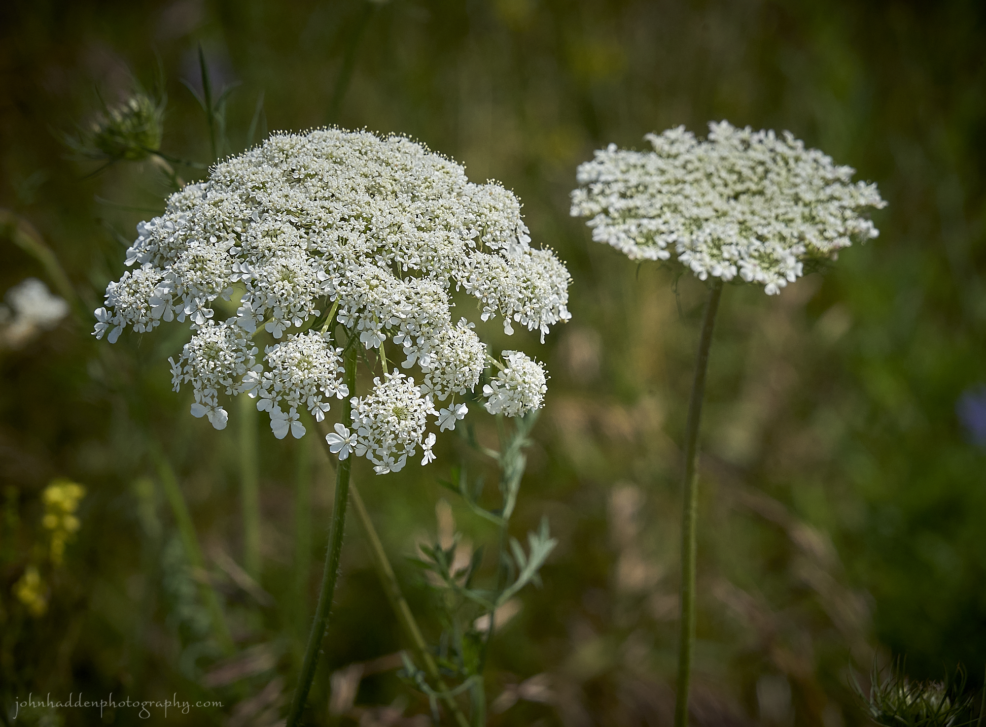 Queen Anne’s lace in its summer glory!
Morning Observation:
This morning in North Hero at 6:50AM it’s currently 69 degrees under partly cloudy skies. Winds are out of the south at 5-7 mph. Relative humidity is 93%, dewpoint 67, barometric pressure 29.99”. We picked up 0.01” of rain yesterday. Yesterday’s high was 80, and yesterday’s low was 68. The overnight low got down to 69.
This morning in Huntington it’s currently 60 degrees under partly cloudy skies. Winds are calm. Relative humidity is 98%, dewpoint 59, barometric pressure 30.04”. We picked up 0.08” of rain yesterday. Yesterday’s high was 86, and yesterday’s low was 56. The overnight low got down to 59.
Forecast Discussion:
Outside of some widely scattered morning showers, we should enjoy another dry day today with highs in the low 80s and partly sunny skies. Wednesday is looking much the same but with slightly warmer highs in the mid 80s, a tad more humidity, and a bit o’ Canadian wildfire smoke. Thursday is looking more stormy than it was just yesterday, as a compact low pressure system is expected to track out of the Great Lakes Wednesday night and over the region on Thursday bringing widespread showers and thunderstorms. There will be quite a bit of moisture to work with so we’ll have to keep an eye out for potential flash flooding during the day on Thursday. Once this system moves through, high pressure is expected to move in on Friday bringing in much warmer and humid air. Highs on Friday are expected to push 90 with dewpoints around 60. A weak shortwave trough is expected to move through later Friday afternoon bringing chances for scattered showers and thunderstorms. A strong cold front is expected to move through on Saturday bringing more thunderstorms, but behind that, we’ll likely see a much cooler airmass move in for the latter part of the weekend and heading into early next week.
3-Day Forecast:
We’ll see partly sunny skies today with a high near 81 and south winds 5-9 mph becoming light in the afternoon. Tonight should be partly cloudy with a low around 62 and light south winds.
Wednesday should be mostly sunny with a high near 85 and south winds to 5 to 10 mph in Huntington and 13-17 mph in the Champlain Valley. Wednesday night should be mostly cloudy with a low around 68 and south winds 8-12 mph.
Thursday should be cloudy with a 60% chance of showers and thunderstorms. Highs will be near 82 with south winds 7-11 mph. Rainfall amounts between 0.75”-1” are possible. Thursday night should be mostly cloudy with showers likely and possibly a thunderstorm before 8:00PM, then a chance of showers and thunderstorms late. Lows will be around 65 with west winds 3-6 mph. Chance of precipitation is 60% with rainfall amounts between 0.25″-0.50″ possible.
Almanac:
Last year on this date in Huntington we had a high of 84 and a low of 60. We picked up 1.17″ of rain.
Last year in North Hero we had a high of 82 and a low of 70. We picked up 0.50″ of rain.
Burlington averages for this date are a low of 63 and a high of 83.
The record low was 46 in 1953.
The record high was 97 in 1963.
The Lake Champlain lake level in Burlington is 98.67′ (going down!)
The water temperature is 75˚.
Last year’s lake level was at 95.15′.
Sky Notes:
Sunrise: 5:31AM
Sunset: 8:24PM
Length of day: 14:53:17
Today will be 2:03 shorter than yesterday.
The Moon is a waxing crescent, 6.8 days old with 43% illumination.
Moonrise: 1:20PM
Moonset: 11:53PM
About Today’s Photo:
Queen Anne’s lace is certainly aptly named as I view it as the queen of summer meadows. The harmless perennial pictured here is also known as wild carrot and its root has a tasty, spicy carrot flavor. Other members of the Apiaceae family include a number of nasty species like wild or poison parsnip, and hemlock.
Sony A7II, Sony 24-240mm lens @ 153mm, ISO 800, f/13, 1/1600″ exposure.
Monday, July 24, 2023
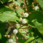
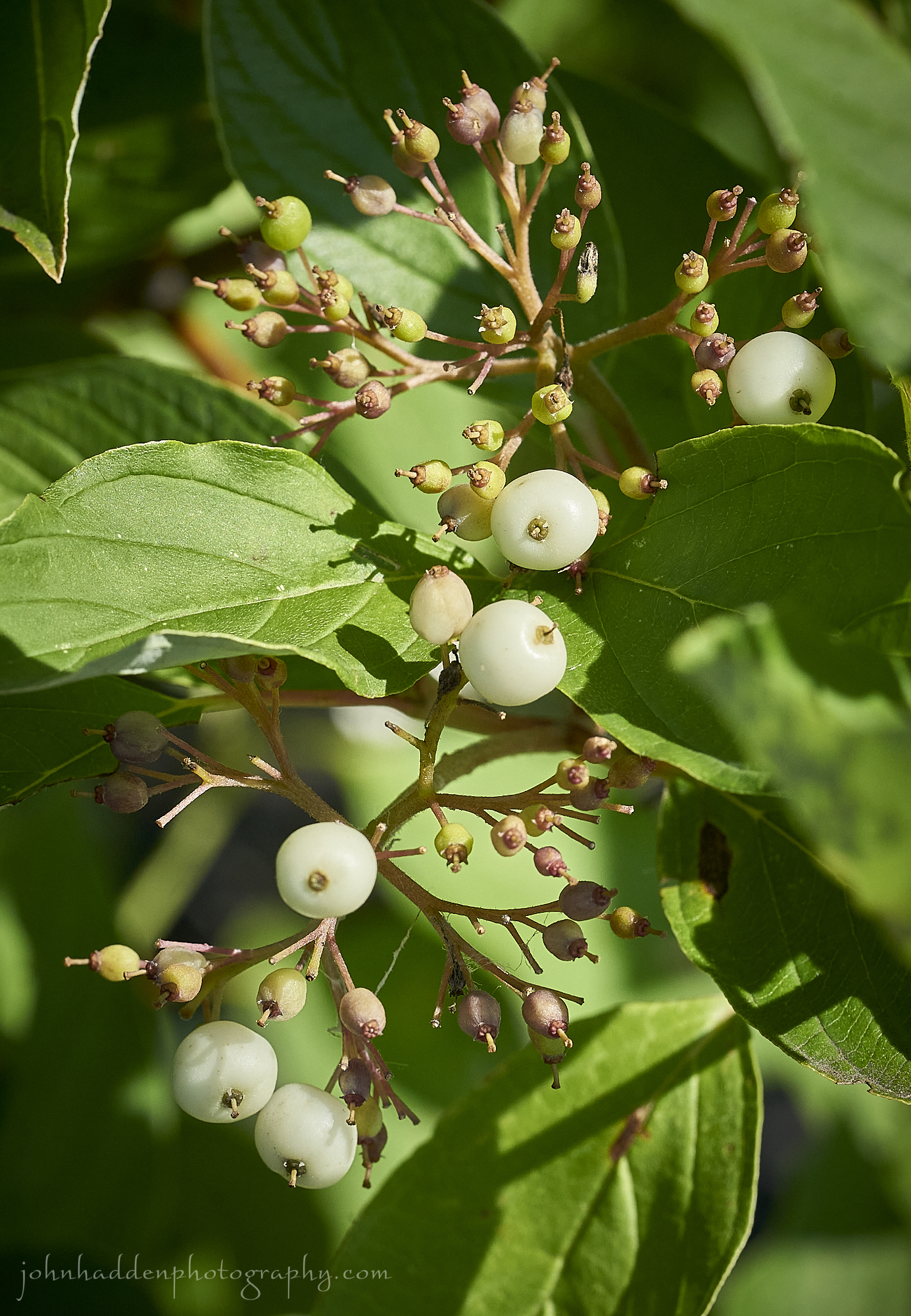 Red osier setting fruit by the lake
Morning Observation:
This morning in North Hero at 6:55AM it’s currently 69 degrees under clear skies. Winds are calm. Relative humidity is 91%, dewpoint 67, barometric pressure 30.02”. Yesterday’s high was 80, and yesterday’s low was 66. The overnight low got down to 68.
This morning in Huntington it’s currently 58 degrees under clear skies. Winds are calm. Relative humidity is 98%, dewpoint 57, barometric pressure 30.07”. Yesterday’s high was 83, and yesterday’s low was 53. The overnight low got down to 56.
Forecast Discussion:
We’ll see mostly sunny skies this morning giving way to widespread showers and thunderstorms this afternoon as deep low pressure to our north drags a sharp trough through the region this afternoon interacting with daytime heating. Some storms may produce briefly heavy rain, hail, and strong winds. The greatest chance for strong to severe storms will be in the 2:00-5:00PM timeframe during the warmest part of the day. Showers and thunderstorms are expected to wind down this evening as the trough flattens out and moves to our east. Some showers may linger into Tuesday. High pressure is expected move in for midweek bringing dry and increasingly warm conditions. Highs on Wednesday should be in the mid to upper 80s and push towards 90 in broader valleys on Thursday along with increased humidity as dew points approaching 70. Looking towards the end of the week, forecast models are hinting at a strong cold front swinging through which should moderate temperatures and humidity as well is bring some more showers and thunderstorms. Pretty typical summer weather… Finally…
3-Day Forecast:
We’ll see mostly clear skies this morning giving way to increasing clouds with showers and thunderstorms likely, mainly between 3:00-5:00PM. Some storms could produce small hail, gusty winds, and heavy rain. Highs will be near 85 with south winds 5-10 mph. Chance of precipitation is 60% with rainfall amounts of 0.10″-0.25″ with higher amounts possible in thunderstorms. Tonight should be mostly cloudy with a 30% chance of showers and thunderstorms, mainly before 9:00PM. Low will be around 65 with south winds 8-12 mph. Rainfall amounts of less than 0.10″ are possible with higher amounts possible in thunderstorms.
Tuesday should be mostly sunny with a 30% chance of showers and thunderstorms, mainly after noon. Highs will be near 82 with south winds 5-10 mph. Rainfall amounts of less than 0.10″ are possible with higher amounts possible in thunderstorms. Tuesday night should be partly cloudy with a low around 62 and light south winds.
Wednesday should be mostly sunny with a high near 86 and southwest winds 6-9 mph. Wednesday night should be mostly cloudy with a low around 65 and south winds 7-12 mph.
Almanac:
Last year on this date in Huntington we had a high of 88 and a low of 62.
Last year in North Hero we had a high of 83 and a low of 75.
Burlington averages for this date are a low of 63 and a high of 83.
The record low was 47 in 1985.
The record high was 96 in 1941.
The Lake Champlain lake level in Burlington is 98.76′ (The level reached 89.79′ at 6:30PM yesterday, so we might be on our way down…)
The water temperature is 75˚.
Last year’s lake level was at 95.10′.
Sky Notes:
Sunrise: 5:30AM
Sunset: 8:25PM
Length of day: 14:55:21
Today will be 2:00 shorter than yesterday.
The Moon is a waxing crescent, 6 days old with 34% illumination.
Moonrise: 12:13PM
Moonset: 11:34PM
About Today’s Photo:
Our neighbors here on the lake planted a lot of red osier along their shoreline after the 2011 flood to help stabilize their bank. The native shrubs are flowing and setting fruit with a nice crop of white berries plumping up. These will be welcome by many birds later in the season.
Sony A7II, Sony 90mm macro lens, ISO 800, f/13, 1/640″ exposure
Sunday, July 23, 2023

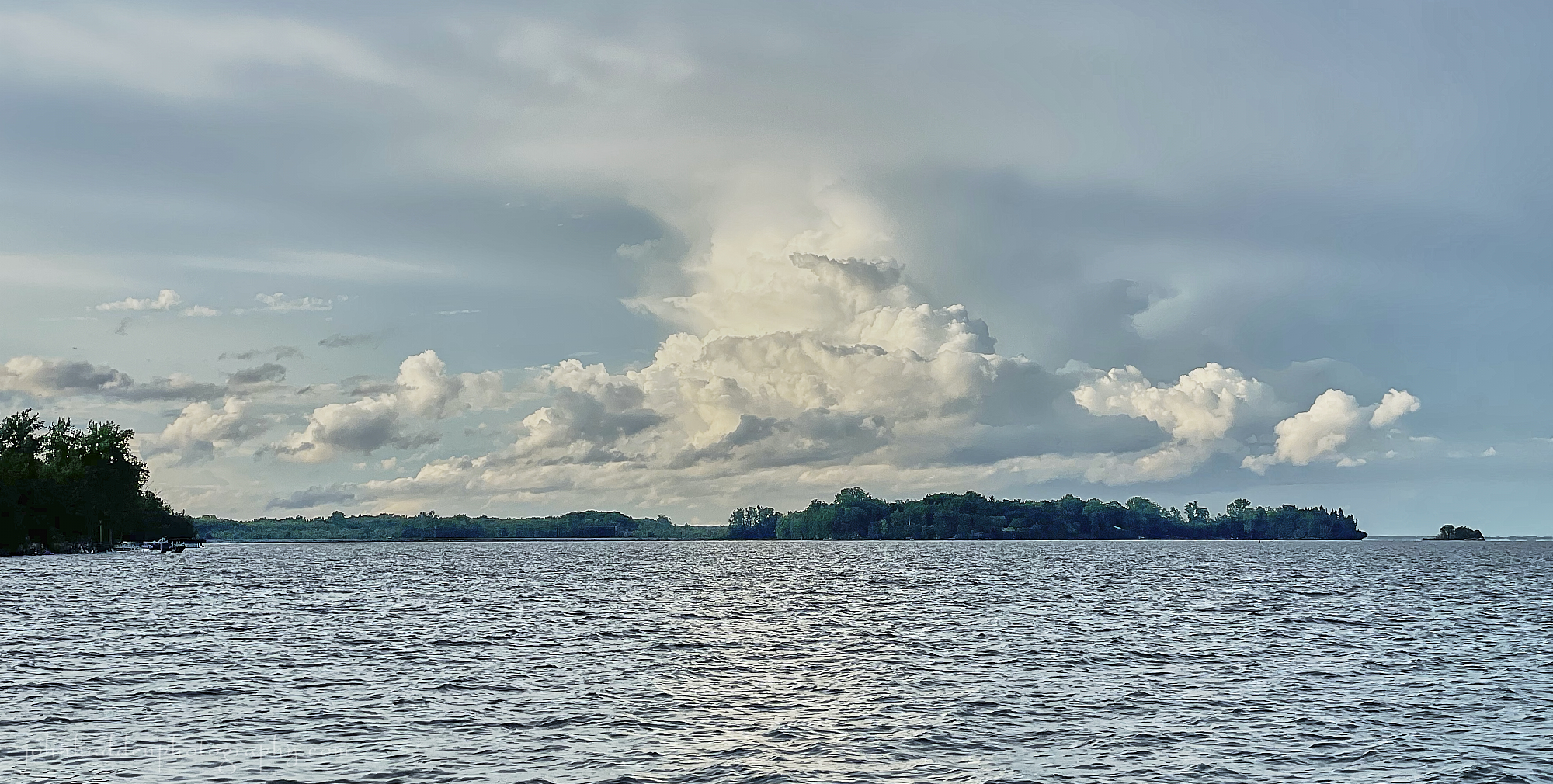 Evening clouds building
Morning Observation:
This morning in North Hero at 7:05AM it’s currently 68 degrees under clear skies. Winds are out of the south at 7-9 mph. Relative humidity is 90%, dewpoint 64, barometric pressure 29.88”. We picked up a total of 0.01” of rain yesterday. Yesterday’s high was 74, and yesterday’s low was 65. The overnight low got down to 66.
This morning in Huntington it’s currently 56 degrees under clear skies. Winds are calm. Relative humidity is 98%, dewpoint 55, barometric pressure 29.92”. We picked up a total of 0.26” for rain yesterday. Yesterday’s high was 77, and yesterday’s low was 57. The overnight low got down to 53.
Forecast Discussion:
Outside of a few widely scattered afternoon showers over northern New York this afternoon, we should see a mostly dry day today with sunny skies and highs in the upper 70s to low 80s. After another mostly dry day on Monday, chances for showers and thunderstorms will increase later Monday afternoon and evening as a quick moving trough slides through bringing more widespread showers and thunderstorms into Tuesday. High pressure is expected to build in for the middle of the week with temperatures and humidity levels rising towards 90 by Thursday.
3-Day Forecast:
We’ll see sunny skies today with a high near 80 and south winds 5-8 mph. Tonight should be mostly clear with a low around 62 and south winds 5-10 mph.
Monday should be sunny with isolated afternoon showers and thunderstorms. Highs will be near 83 with south winds 5-7 mph in Huntington and 10-15 mph in the Champlain Valley. Monday night should be mostly cloudy with a 30% chance of showers. Lows will be around 64 with south winds 6-8 mph in Huntington and 10-15 mph in the Champlain Valley. Rainfall amounts of less than 0.10″ are possible.
Tuesday should be partly sunny with a 70% chance of showers and thunderstorms. Highs will be near 83 with south winds 7-10 mph. Rainfall amounts of less than 0.10″ are possible with higher amounts possible in thunderstorms. Tuesday night should be partly cloudy with a 30% chance of showers before 8:00PM. Lows will be around 61 with light south winds.
Almanac:
Last year on this date in Huntington we had a high of 89 and a low of 59.
Last year in North Hero we had a high of 87 and a low of 71.
Burlington averages for this date are a low of 63 and a high of 83.
The record low was 46 in 1977.
The record high was 93 in 2022 (see above).
The Lake Champlain lake level in Burlington is 98.73′.
The water temperature is 75˚.
Last year’s lake level was at 95.16′.
Sky Notes:
Sunrise: 5:29AM
Sunset: 8:26PM
Length of day: 14:57:21
Today will be 1:57 shorter than yesterday.
The Moon is a waxing crescent, 5 days old with 25% illumination.
Moonrise: 11:09AM
Moonset: 11:17PM
About Today’s Photo:
We had dinner at a local waterfront restaurant the other evening and watched as some lovely cumulus clouds built up north of our point. These are classic summertime cumulus!
iPhone 12 Pro
Saturday, July 22, 2023; Peak Meteorological Summer

 Still life with flotsam & eel
Morning Observation:
This morning in North Hero at 7:30AM it’s currently 67 degrees under mostly cloudy skies. Winds are out of the southwest at 3-4 mph. Relative humidity is 85%, dewpoint 62, barometric pressure 29.69”. We picked up 0.65” of rain yesterday and 0.01” so far today. Yesterday’s high was 77, and yesterday’s low was 67. The overnight low got down to 65.
This morning in Huntington it’s currently 62 degrees under mostly cloudy skies. Winds are calm. Relative humidity is 98%, dewpoint 62, barometric pressure 29.73”. We picked up 0.61” of rain yesterday and 0.26” so far today. Yesterday’s high was 79, and yesterday’s low was 57. The overnight low got down to 59.
Forecast Discussion:
The slow moving low pressure system that brought yesterday’s showers and thunderstorms is parked just to our north this morning. It will slowly move to the northeast today, rotating in seasonably cool air and perhaps sparking a few garden-variety showers during the day today, but nothing like we’ve been experiencing recently. Dry conditions are expected to move in later tonight with high pressure building in for the remainder of the weekend and into early next week. Sunday is looking great with highs in the upper 70s to low 80s with comfortable humidity levels. I alluded to yesterday, the high pressure “block” over Greenland is finally beginning to break down allowing for a return to a more zonal flow of weather systems across the continental US and Canada (something that we have not been seeing all summer…) What this means for us is that low pressure systems will no longer become “stuck” over the northeast dumping copious rains over sustained periods. So, heading into next week, outside of a few possible showers later Monday afternoon into Tuesday as a trough swings through, we’ll be seeing mostly dry conditions with increasing heat and humidity towards the middle/end of the week. Sounds good to me!
3-Day Forecast:
We’ll start off with mostly cloudy skies this morning with a 20% chance of afternoon showers. Skies should gradually become mostly sunny with a high near 76 with southwest winds 5-10 mph. Tonight should be mostly clear with a low around 58 and south winds 5-10 mph.
Sunday should be sunny with a high near 82 and southwest winds 4-8 mph becoming calm in the afternoon. Sunday night should be mostly clear with a low around 60 and light south winds.
Monday should be mostly sunny with a 30% chance of afternoon showers. Highs will be near 84 with south winds 5-10 mph. Rainfall amounts of less than 0.10″ are possible. Monday night should be partly cloudy with a 20% chance of showers before 7:00PM. Lows will be around 62 with south winds 6-10 mph.
Almanac:
Last year on this date in Huntington we had a high of 88 and a low of 59.
Last year in North Hero we had a high of 87 and a low of 71.
Burlington averages for this date are a low of 63 and a high of 83.
The record low was 45 in 1992.
The record high was 97 in 1955.
The Lake Champlain lake level in Burlington is 98.63′.
The water temperature is 75˚.
Last year’s lake level was at 95.18′.
Sky Notes:
Sunrise: 5:28AM
Sunset: 8:27PM
Length of day: 14:59:19
Today will be 1:55 shorter than yesterday.
The Moon is a waxing crescent, 4 days old with 18% illumination.
Moonrise: 10:06AM
Moonset: 11:01PM
Today marks Peak Meteorological Summer for our region. This is based on the annual temperature cycles and represents the peak of the warmest weather in our part of the northern hemisphere. You can read more about it here.
About Today’s Photo:
With high water levels and a pounding south wind driven surf yesterday, all kinds of things were washing up on our south-facing cove beach. We often will find fish washed ashore, but this freshwater eel was a bit of a surprise. This fellow was about 3′ long!
Sony A7II, Sony 24-240mm lens @ 45mm, ISO 800, f/11, 1/400″ exposure
Friday, July 21, 2023

 Funnel-veil amanita mushrooms pushing their way through the leaf litter by Indian Lake, NY
Morning Observation:
This morning in North Hero at 7:05AM it’s currently 69 degrees and raining steadily under overcast skies. Winds are out of the south at 15-17 mph. Relative humidity is 95%, dewpoint 67, barometric pressure 29.71”. We picked up 0.44” of rain so far today. Yesterday’s high was 80, and yesterday’s low was 66, The overnight low got down to 67.
This morning in Huntington it’s currently 64 degrees and raining under overcast skies. Winds are calm. Relative humidity is 97%, dewpoint 63, barometric pressure 29.75”. We picked up 0.47” of rain so far today. Yesterday’s high was 84, and yesterday’s low was 52. The overnight low got down to 57.
Flood Watches have been posted for most of Vermont today from noon today until 2:00AM Saturday.
Forecast Discussion:
Morning radar imagery shows a tight area of low pressure over Ottawa at this hour with a distinct band of shower and thunderstorms pushing its way through Vermont. These morning showers and thunderstorms should wind down this morning as a well-defined dry slot works its way in by mid-morning. As the aforementioned low moves slowly northeastward during the day today, showers and thunderstorms will redevelop this afternoon with the help of diurnal heating. Some of these storms may “train”, meaning that they’ll line up to bring repeated slugs of heavy rains over the same area as they move through. Unfortunately, this training effect is most likely to occur over portions of south/central Vermont this afternoon where previous rains have already done a lot of damage. Subsequently, Flood Watches have been posted from noon today until 2:00AM Saturday. If you’re in a flood prone area, please take care and stay alert. Showers and thunderstorms are expected to wind down tonight with only a slight chance of scattered showers extending into Saturday morning/afternoon. Thereafter, high pressure is expected to build in to dry things out Saturday evening and into Sunday. Sunday’s looking dry and seasonable with sunny skies, light winds, and highs in the upper 70s to low 80s. Monday is looking much the same. Perfect. We’ll take it! I’m also glad to report that the NWS is expecting a widespread pattern change for the northeast heading into next week with a more “zonal” flow setting up. This will allow for any storms to move more quickly through the region than we’ve been seeing for, well, most of this summer. This will hopefully greatly reduce the threat of flooding moving forward. That’s very good news!
3-Day Forecast:
We’ll see cloudy skies today with showers and thunderstorm before 11:00AM, then showers and thunderstorms likely this afternoon. Some of the storms could produce heavy rain and frequent lightning this afternoon. Highs will be near 75 with south winds 6-11 mph in Huntington and 15-23 mph in the Champlain Valley. Chance of precipitation is 90% with rainfall amounts between 0.50”-0.75” possible. Tonight should be mostly cloudy with showers and thunderstorms likely before 2:00AM, then a slight chance of showers. Some of the storms could produce heavy rain and frequent lightning. Lows will be around 60 with south winds 3-8 mph in Huntington and 7-14 mph in the Champlain Valley. Chance of precipitation is 70% with rainfall amounts between 0.25″-0.50″ with higher amounts possible in thunderstorms.
Saturday should be partly sunny with scattered showers, with thunderstorms possible in the afternoon. Highs will be near 74 with southwest winds 5-7 mph. Chance of precipitation is 40% with rainfall amounts of less than 0.10″ with higher amounts possible in thunderstorms. Saturday night should be partly cloudy with a low around 57 and light southwest winds.
Sunday should be sunny with a high near 81 and light west winds. Sunday night should be mostly clear with a low around 58 and light and variable winds.
Almanac:
Last year on this date in Huntington we had a high of 90 and a low of 68. We picked up 0.44″ of rain.
Last year in North Hero we had a high of 86 and a low of 75. We picked up 0.06″ of rain.
Burlington averages for this date are a low of 63 and a high of 83.
The record low was 45 in 1966.
The record high was 97 in 2011 (we had a high of 93 in Huntington).
The Lake Champlain lake level in Burlington is 98.59′
The water temperature is 77˚.
Last year’s lake level was at 95.23′.
Sky Notes:
Sunrise: 5:27AM
Sunset: 8:28PM
Length of day: 15:01:14
Today will be 1:52 shorter than yesterday.
The Moon is a waxing crescent, 3 days old with 11% illumination.
Moonrise: 9:02AM
Moonset: 10:44PM
About Today’s Photo:
I was in Indian Lake, NY Wednesday night (hence the lack of blog yesterday…) There were several spots along the shore of the lake where funnel-veil amanita mushrooms were pushing their way up through the leaf litter. They emerge as tight balls that expand to broad, classic mushroom caps (see photo below) While quite lovely in appearance with their creamy caps, amanita should be considered toxic.
![amanita-full]](https://eaststreetweatherblog.files.wordpress.com/2023/07/amanita-full.jpg)
iPhone 12 Pro
Wednesday, July 19, 2023

 Echinacea blooming in our island garden
Morning Observation:
This morning in North Hero at 6:35AM it’s currently 69 degrees under partly cloudy skies. Winds are out of the south at 2-4 mph. Relative humidity is 87%, dewpoint 65, barometric pressure 29.93”. We picked up just a trace of rain yesterday. Yesterday’s high was 78, and yesterday’s low was 68. The overnight low got down to 68.
This morning in Huntington it’s currently 60 degrees under partly cloudy skies. Winds are calm. Relative humidity is 98%, dewpoint 59, barometric pressure 29.97”. We picked up 0.77” of rain yesterday. Yesterday’s high was 86, and yesterday’s low was 66. The overnight low got down to 59.
Forecast Discussion:
I’ll try not to jinx it, but we’ve got a couple of days of nice summer weather on tap courtesy of high pressure that is building into the region. We’ll see highs in the low 80s today and Thursday with comfortable humidity levels and mostly sunny skies. Clouds will be on the increase Thursday evening out ahead of our next weather-maker. Low pressure tracking out of the Great Lakes will bring more widespread rain and afternoon thunderstorms Friday. Some storms may produce heavy rainfall, and, with saturated soils in place, flood watches will likely be posted again. Showers and thunderstorms are expected to become more scattered in nature on Saturday and wind down in the evening. The low should clear the region overnight Saturday with a dry and seasonable day expected for Sunday and Monday. Then more rain is likely midweek…
3-Day Forecast:
We’ll see mostly sunny skies today with a high near 80 and west winds 5-8 mph. Tonight should be partly cloudy with a low around 58 in Huntington and 64 in North Hero with north winds around 6 mph becoming calm in the evening.
Thursday should be mostly sunny with a 20% chance of showers after 5:00PM. Highs will be near 83 with calm winds becoming southwesterly around 6 mph in the afternoon. Thursday night should be mostly cloudy with a 30% chance of showers late. Lows will be around 63 with south winds 5-10 mph. rainfall amounts of less than 0.10″ are possible.
Friday should be mostly cloudy with a 70% chance of showers and thunderstorm. Highs will be near 77 with south winds 6-11 mph. Rainfall amounts between 0.50”-0.75” are possible. Friday night should be mostly cloudy with scattered showers and thunderstorms before 2:00AM. Lows will be around 63 with south winds 5-9 mph. Chance of precipitation is 50% with rainfall amounts between 0.10″-0.25″ with higher amounts possible in thunderstorms.
Almanac:
Last year on this date in Huntington we had a high of 87 and a low of 64. We picked up 0.44″ of rain.
Last year in North Hero we had a high of 85 and a low of 68. We picked up 0.07″ of rain.
Burlington averages for this date are a low of 63 and a high of 83.
The record low was 48 in 1970.
The record high was 98 in 2013 (we had a high of 90 in Huntington).
The Lake Champlain lake level in Burlington is 98.55′.
The water temperature is 75˚.
Last year’s lake level was at 95.26′.
Sky Notes:
Sunrise: 5:25AM
Sunset: 8:30PM
Length of day: 15:04:56
Today will be 1:46 shorter than yesterday.
The Moon is a waxing crescent, 1.3 days old with 2% illumination.
Moonrise: 6:53AM
Moonset: 10:05PM
About Today’s Photo:
I’ve always been entranced by echinacea blossoms. I can just get lost in the spiny paleae that make up the blossoms’ centers. This North American native plant was classified by botanist Conrad Moench in 1794 and derives its name from the from the Greek word ἐχῖνος (ekhinos) for hedgehog or sea-urchin. The things ya learn in Wikipedia…
Sony A7II, Sony 90mm macro lens, ISO 200, f/3.2, 1/1600″ exposure
Tuesday, July 18, 2023

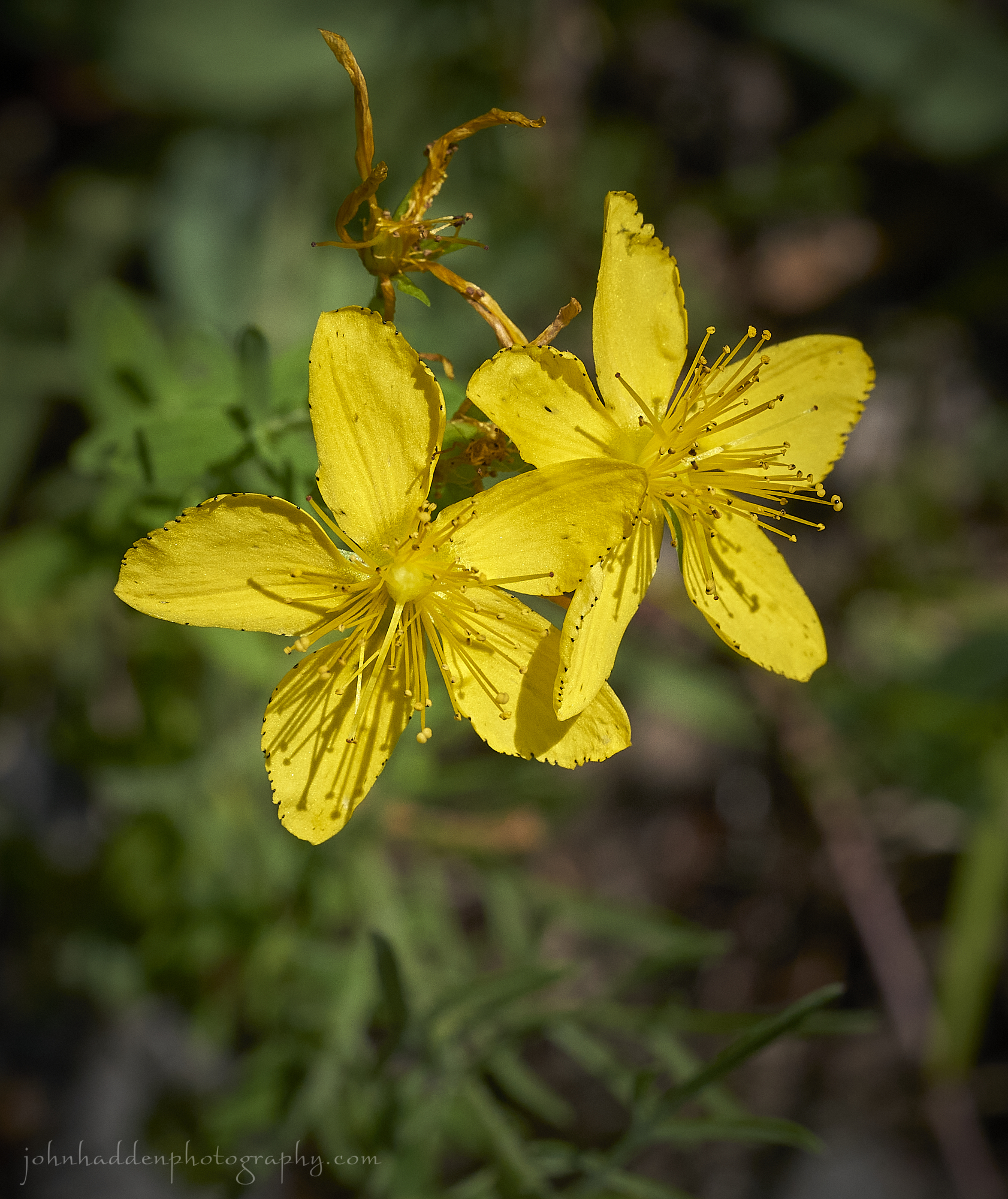 St. Johns wort blooming at Alburgh Dunes State Park
Morning Observation:
This morning in North Hero at 7:10AM it’s currently 68 degrees and raining lightly under overcast skies. Winds are out of the north at 2-4 mph. Relative humidity is 92%, dewpoint 66, barometric pressure 29.90”. Yesterday’s high was 83, and yesterday’s low was 71. The overnight low got down to 68.
This morning in Huntington it’s currently 69 degrees and raining under overcast skies. Winds are calm. Relative humidity is 98%, dewpoint 68, barometric pressure 29.91”. We picked up 0.07” of rain so far today. Yesterday’s high was 85, and yesterday’s low was 63. The overnight low got down to 66.
There is a Flood Watch in effect for our region from noon today until late tonight.
Forecast Discussion:
Morning radar imagery shows a band of showers currently lifting through northern New York and Vermont. These showers are expected to wind down this morning with a brief dry spell midday before a cold front drops through the region this afternoon sparking more showers and thunderstorms this afternoon and into the evening. Some storms could produce some brief heavy rains, so Flood Watches have once again been posted for most of Vermont. We’re not out of the woods yet… Showers and thunderstorms are expected to wind down overnight as high pressure builds into the region bringing two-count-’em-two whole days of dry and seasonable weather Wednesday and Thursday!!! Highs both days are expected to be in the low 80s with comfortable humidity levels (what’s that?!?!) But don’t get too excited, as low pressure trudging out of the Great Lakes on Friday is expected to take up residence over the northeast over the weekend bringing widespread rains on Friday, with scattered showers expected Saturday and Sunday.
3-Day Forecast:
We’ll see partly sunny skies today with morning showers and thunderstorms possible, with showers and thunderstorms redeveloping in the afternoon. Some of the storms could produce heavy rain. Highs will be near 80 with southwest winds 6-8 mph. Chance of precipitation is 70% with rainfall amounts between 0.25″-0.50″ with higher amounts possible in thunderstorms. Tonight should be mostly cloudy with showers and thunderstorms likely. Some of the storms could produce heavy rain. Skies should gradually become mostly clear with a low around 61 and south winds around 5 mph. Chance of precipitation is 60% with rainfall amounts between 0.25″-0.50″ possible.
Wednesday should be sunny with a high near 81 and west winds 5-8 mph. Wednesday night should be mostly clear with a low around 58 with light south winds.
Thursday should be mostly sunny with a high near 83 and calm wind becoming southerly around 6 mph in the afternoon. Thursday night should be partly cloudy with a 50% chance of showers late. Lows will be around 61 with south winds 5-9 mph. New precipitation amounts of less than 0.10″ are possible.
Almanac:
Last year on this date in Huntington we had a high of 77 and low of 60. We picked up 0.49″ of rain.
Last year in North Hero we had a high of 77 and a low of 71. We picked up 0.47″ of rain.
Burlington averages for this date are a low of 63 and a high of 83.
The record low was 47 in 1956.
The record high was 99 in 1953.
The Lake Champlain lake level in Burlington is 98.44′.
The water temperature is 76˚.
Last year’s lake level was at 95.23′.
Sky Notes:
Sunrise: 5:24AM
Sunset: 8:31PM
Length of day: 15:06:42
Today will be 1:43 shorter than yesterday.
The Moon is a waxing crescent, 0.5 days old with 0.2% illumination.
Moonrise: 5:47AM
Moonset: 9:40PM
About Today’s Photo:
St. Johns wort is native to Eurasia and was brought to the Americas where it has become something of an invasive. St John’s wort is named because it commonly flowers and is harvested at the time of the summer solstice in late June, around St John’s Feast Day on 24 June. It has a variety of uses in traditional herbal medicine.
Sony A7II, Sony 90mm macro lens, ISO 800, f/13, 1/1000″ exposure.
Monday, July 17, 2023

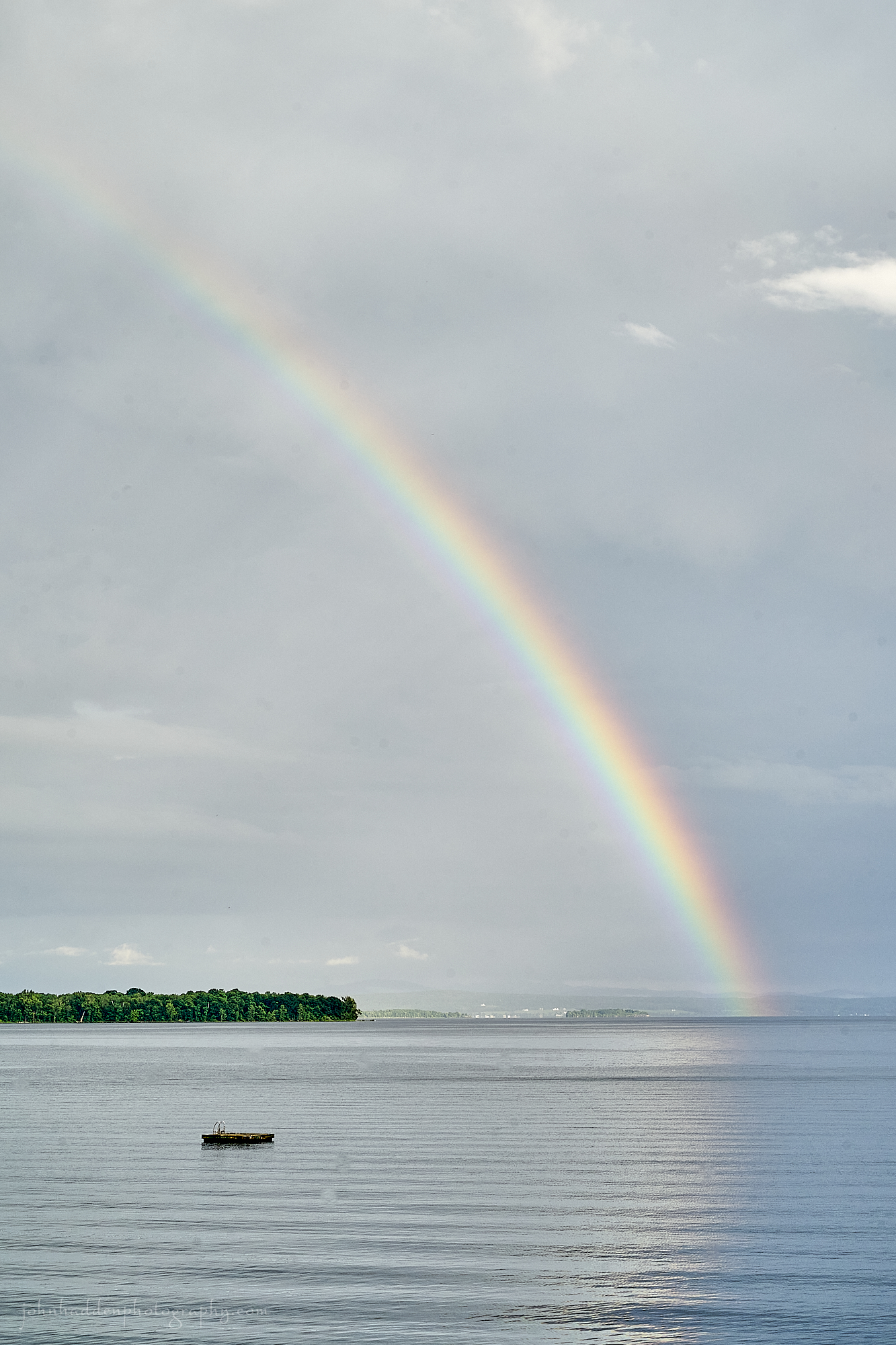 A rainbow stretches over Knight Island yesterday evening
Morning Observation:
This morning in North Hero at 7:15AM it’s currently 72 degrees under mostly cloudy skies. Winds are out of the south at 9-12 mph. Relative humidity is 95%, dewpoint 71, barometric pressure 29.79”. We picked up 0.03” of rain yesterday. Yesterday’s high was 79, and yesterday’s low was 73. The overnight low got down to 71.
This morning in Huntington it’s currently 66 degrees under mostly cloudy skies. Winds are calm. Relative humidity is 98%, dewpoint 65, barometric pressure 29.83”. We picked up 2.09” of rain yesterday afternoon/evening, and there was a lot of flash flooding in Huntington and Richmond were several roads were closed due to washouts. Yesterday’s high was 85, and yesterday’s low was 65. The overnight low got down to 63.
Forecast Discussion:
We’ve got a rare dry day on tap for today courtesy of a ridge of high pressure cresting over the region. Highs today will range from the low to mid 80s with breezy south winds and a soupçon of wildfire smoke. As has been our lot this summer, however, the dry spell will be short-lived as another trough of low pressure is expected to cross the region on Tuesday with chances for showers increasing late tonight into Tuesday. Showers should wind down by Tuesday night with dry and seasonable conditions expected Wednesday and most of Thursday. Another trough of low pressure is expected to track out of the Great Lakes on Thursday and move slowly into the Gulf of St. Lawrence by Saturday. This will likely bring rounds of afternoon showers and thunderstorms Friday and Saturday before the low finally pulls away on Sunday morning.
3-Day Forecast:
We’ll see mostly sunny skies today with patchy smoke from Canadian wildfires. Highs will be near 82 with south winds 5-8 mph in Huntington and 10-13 mph in the Champlain Valley. Tonight should be mostly cloudy with a 20% chance of showers and thunderstorms late. Lows will be around 67 with south winds around 5-8 mph.
Tuesday should be mostly cloudy with a 40% chance of showers and thunderstorms. Highs will be near 78 with south winds 3-7 mph. Rainfall amounts between 0.25″-0.50″ are possible. Tuesday night should be mostly cloudy with a 30% chance of showers before 10:00PM. Lows will be around 61 with light south winds. Rainfall amounts between 0.10″-0.25″ are possible.
Wednesday should be mostly sunny with a high near 81 and west winds 3-7 mph. Wednesday night should be mostly clear with a low around 59 and light and variable winds.
Almanac:
Last year on this date in Huntington we had a high of 89 and a low of 52.
Last year in North Hero we had a high of 85 and a low of 67.
Burlington averages for this date are a low of 63 and high of 83.
The record low was 48 in 1973.
The record high was 97 in 1999 (we had a high of 90 in Huntington).
The Lake Champlain lake level in Burlington is 98.27′.
The water temperature is 75˚.
Last year’s lake level was at 95.27′ (that’s a 3-foot difference folks!)
Sky Notes:
Sunrise: 5:23AM
Sunset: 8:32PM
Length of day: 15:08:25
Today will be 1:40 longer than yesterday.
The Moon is new, 29 days old with 0% illumination.
Moonrise: 4:43AM
Moonset: 9:09PM
About Today’s Photo:
While Huntington and Richmond were getting once again pummeled by rain yesterday evening, we were treated to a lovely rainbow arching over Knight Island for about an hour. Considering all the rainy days we’ve had this summer, it’s the first rainbow that I can recall this season. Guess ya gotta have rain to have rainbows…
Sony A7II, Sony 24-240mm lens @ 57mm, ISO 800, f/13, 1/160″ exposure
Sunday, July 16, 2023

 Ants aphid farming on the beach
Morning Observation:
This morning in North Hero at 6:55AM it’s currently 75 degrees and raining lightly under overcast skies. Winds are out of the south at 4-5 mph. Relative humidity is 89%, dewpoint 72, barometric pressure 29.76”. Yesterday’s high was 82, and yesterday’s low was 69. The overnight low got down to 75.
This morning in Huntington it’s currently 69 degrees and raining under overcast skies. Winds are calm. Relative humidity is 97%, dewpoint 65, barometric pressure 29.80”. We picked up 0.05” of rain so far today. Yesterday’s high was 86, and yesterday’s low was 59. The overnight low got down to 65.
There is a Flood Watch in effect for most of Vermont from 6:00AM this morning until 6:00AM Monday.
Forecast Discussion:
Another day, another rainy day in the North Country… Morning radar imagery shows a trough of low pressure over eastern Pennsylvania at this hour which is expected to move northeastward into the North Country. Rainfall is expected to come in two stages today, with this initial trough bringing morning showers, and a second trough, reinforced with deep subtropical jetstream moisture, bringing more and potentially heavier rains and thunderstorms this afternoon and evening. Most of Vermont under a Flood Watch for the day, and, though this round of storms isn’t expected to be nearly as heavy or widespread as the history-making rains of last week, given antecedent saturated soil conditions it won’t take much for flash flooding to occur. Fortunately the system is fairly progressive and should move off later tonight. A brief ridge of high pressure is expected to move in for Monday allowing for some drying before the next trough swings through later Monday night into Tuesday. After another short dry stretch Wednesday into Thursday, more showers are expected to arrive Thursday evening and linger into the weekend.
3-Day Forecast:
We’ll see cloudy skies today with showers and possibly a thunderstorm. Some of the storms could produce heavy rain. Highs will be near 78 with south winds 7-12 mph. Chance of precipitation is 100% with rainfall amounts between 0.75”-1” possible. Tonight should be cloudy with showers likely and possibly a thunderstorm before 8:00PM, becoming scattered late. Lows will be around 67 with south winds around 7 mph in Huntington and 9-15 mph in the Champlain Valley. Chance of precipitation is 60% with rainfall amounts between 0.10″-0.25″ with higher amounts possible in thunderstorms.
Monday should be mostly sunny with a high near 86 and south winds 4-8 mph. Monday night should be mostly clear with a 30% chance of showers late. Lows will be around 64 with southwest winds 3-6 mph.
Tuesday should be cloudy with showers likely, with afternoon thunderstorm. Highs will be near 81 with south winds 5-8 mph. Chance of precipitation is 80% with rainfall amounts between 0.25″-0.50″ possible. Tuesday night should be mostly cloudy with showers, mainly before 8:00PM. Lows will be around 60 with south winds around 6 mph. Chance of precipitation is 80% with rainfall amounts between 0.10″-0.25″ possible.
Almanac:
Last year on this date in Huntington we had a high of 84 and a low of 52.
Last year in North Hero we had a high of 82 and a low of 67. We picked up 0.07″ of rain.
Burlington averages for this date are a low of 63 and a high of 83.
The record low was 44 in 1946.
The record high was 96 in 2018 (we had a high of 93 in Huntington).
The Lake Champlain lake level in Burlington is 98.11′ (same lake level as May 18 of this spring…)
The water temperature is 75˚.
Last year’s lake level was at 95.33′.
Sky Notes:
Sunrise: 5:22AM
Sunset: 8:32PM
Length of day: 15:10:05
Today will be 1:36 shorter than yesterday.
The Moon is a waning crescent, 28 days old with 2% illumination.
Moonrise: 3:45AM
Moonset: 8:29PM
About Today’s Photo:
While I was taking shots of bees in buttonbush yesterday, I noted this aphid farm in process on a poplar sapling. In a classic example of symbiotic behavior, ants will foster a clutch of aphids in order to have access to the sweet nectar which is part of the aphids digestive process. You can see a couple of other insects doing a little freeloading as well.
Sony A7II, Sony 90mm macro lens, ISO 800, f/13, 1/160″ exposure
Saturday, July 15, 2023

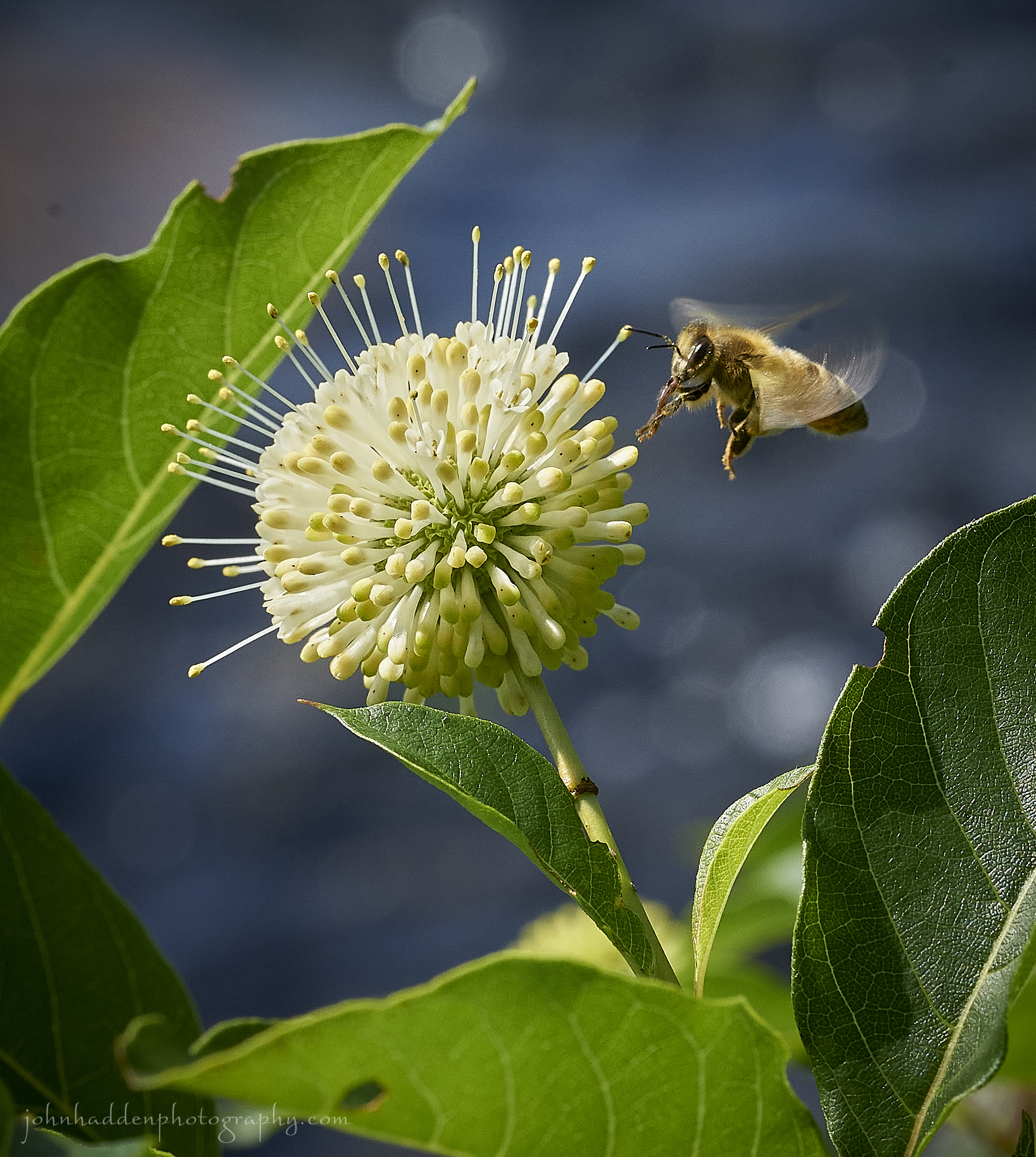 A honey bee approaches a buttonbush blossom
Morning Observation:
This morning in North Hero at 7:10AM it’s currently 71 degrees under partly cloudy skies. Winds are out of the south at 4-6 mph. Relative humidity is 92%, dewpoint 68, barometric pressure 29.91”. Yesterday’s high was 80, and yesterday’s low was 67. The overnight low got down to 69.
This morning in Huntington it’s currently 63 degrees under partly cloudy skies. Winds are calm. Relative humidity is 98%, dewpoint 63, barometric pressure 29.93”. We picked up 0.25” of rain yesterday. Yesterday’s high was 83, and yesterday’s low was 58. The overnight low got down to 59.
A Flash Flood Watch has been posted for most of Vermont (excluding the Champlain Islands) from 8:00AM Sunday until 8:00PM Sunday.
Forecast Discussion:
We’ve got a pretty nice, albeit, warm and muggy day on tap for today courtesy of a brief ridge of the high pressure cresting over the region. Outside of a possible pop-up scattered afternoon thunderstorm, we should see mostly dry conditions with highs in the mid to upper 80s and light south winds. Low pressure tracking out of the Great Lakes on Sunday will drag a trough through region Sunday bringing another round of widespread rain and thunderstorms starting Sunday morning and persisting through much of the day. Some storms may produce heavy downpours and gusty winds with rainfall possibly 1″-2″ in Huntington. Flash Flood Warnings have been posted for most of Vermont where soils are already quite saturated. Showers and thunderstorms are expected to wind down Sunday night with a ridge of high pressure building in for Monday bringing dry and mostly sunny conditions with seasonable temperatures. Chances for showers will increase again later Monday night into Tuesday as our next trough slides through. At this point, midweek is looking dry before the next round of showers arrives on Thursday into Friday.
3-Day Forecast:
We’ll see mostly sunny skies today with a high near 85 and south winds 3-7 mph. Tonight should be mostly cloudy with a 30% chance of showers and thunderstorms late. Lows will be around 70 with south winds 3 to 6 mph in Huntington and 6-14 mph in the Champlain Valley.
Sunday should be cloudy with showers and thunderstorms. Some storms could produce heavy rain. Highs will be near 80 with south winds 6-8 mph in Huntington and 11-14 mph in the Champlain Valley. Chance of precipitation is 80% with rainfall amounts between 1″-2″ possible in Huntington and 0.25″-0.50″ in North Hero. Sunday night should be mostly cloudy with a 50% chance of showers and thunderstorms. Lows will be around 65 with south winds 5-9 mph. Rainfall amounts between 0.25″-0.50″ are possible in Huntington with less than 0.10″ in North Hero.
Monday should be mostly sunny with a high near 86 and south winds 6-10 mph. Monday night should be partly cloudy with a 30% chance of showers lated. Lows will be around 64 with south winds 5-7 mph.
Almanac:
Last year on this date in Huntington we had a high of 81 and a low of 49.
Last year in North Hero we had a high of 80 and a low of 58.
Burlington averages for this date are a low of 63 and a high of 83.
The record low was 44 in 1960.
The record high was 93 in 2013 (we had a high of 90 in Huntington).
The Lake Champlain lake level in Burlington is 97.99′
The water temperature is 73˚.
Last year’s lake level was at 95.38′.
Sky Notes:
Sunrise: 5:21AM
Sunset: 8:33PM
Length of day: 15:11:42
Today will be 1:33 shorter than yesterday.
The Moon is a waning crescent, 27 days old with 5% illumination.
Moonrise: 2:54AM
Moonset: 7:40PM
About Today’s Photo:
There’s a buttonbush blooming on the beach now. Several different pollinators are attracted to the fanciful round blossoms including this honey bee that was buzzing from flower to flower.
Sony A7II, Sony 90mm macro lens, ISO 800, f/13, 1/640″ exposure
Friday, July 14, 2023

 A daylily blooms by the Huntington Gorge
Morning Observation:
This morning in North Hero at 7:10AM it’s currently 69 degrees under partly cloudy skies. Winds are out of the south at 2-4 mph. Relative humidity is 91%, dewpoint 66, barometric pressure 29.88”. We picked up 0.05” of rain yesterday. Yesterday’s high was 84, and yesterday’s low was 66. The overnight low got down to 67.
This morning in Huntington it’s currently 62 degrees under partly cloudy skies. Winds are calm. Relative humidity is 98%, dewpoint 62, barometric pressure 29.91”. We picked up 0.48” of rain yesterday. Yesterday’s high was 86, and yesterday’s low was 57. The overnight low got down to 58.
Forecast Discussion:
A cold front that crossed the region yesterday sparking some strong to severe thunderstorms has settled to the south across Massachusetts this morning where it is expected to become quasi-stationary. This will allow for some showers and thunderstorms across the region this afternoon, however, any storms should be much less impactful than yesterday’s. Saturday is looking seasonably warm with some afternoon convective showers possible. Low pressure tracking to our north on Sunday is expected drag a trough through the region bringing more widespread and organized showers and thunderstorms during the day on Sunday. At this point, Monday is looking mostly dry with more showers and thunderstorms expected midweek.
3-Day Forecast:
We’ll see increasing clouds today with showers likely and possibly a thunderstorm after 3:00PM. Highs will be near 83 with light and variable winds. Chance of precipitation is 60% in Huntington and 30% in North Hero with rainfall amounts of less than 0.10″ with higher amounts possible in thunderstorms. Tonight should be mostly cloudy with a 30% chance of showers and thunderstorms. Lows will be around 65 with south winds 5-8 mph. Rainfall amounts of less than 0.10″ are possible with higher amounts possible in thunderstorms.
Saturday should be partly sunny with a slight chance of afternoon showers and thunderstorms. Highs will be near 85 with south winds 3-8 mph. Saturday night should be mostly cloudy with a 50% chance of showers. Lows will be around 68 with southeast winds 6-10 mph. Rainfall amounts of less than 0.10″ are possible.
Sunday should be mostly cloudy with showers. Highs will be near 81 with south winds 7-11 mph in Huntington and 14-18 mph in the Champlain Valley. Chance of precipitation is 90% with rainfall amounts between 0.50”-0.75” possible. Sunday night should be cloudy with showers, mainly before 8:00PM. Lows will be around 65 with south winds 5-9 mph. Chance of precipitation is 80% with rainfall amounts of 0.10″-0.25″ possible.
Almanac:
Last year on this date in Huntington we had a high of 76 and a low of 60. We picked up 0.08″ of rain.
Last year in North Hero we had a high of 74 and a low of 61. We picked up 0.25″ of rain.
Burlington averages for this date are a low of 63 and a high of 83.
The record low was 50 in 1990.
The record high was 100 in 1995.
The Lake Champlain lake level in Burlington is 97.86′ (the climb does seem to be leveling however…)
The water temperature is 74˚.
Last year’s lake level was at 95.40′.
Sky Notes:
Sunrise: 5:21AM
Sunset: 8:34PM
Length of day: 15:13:16
Today will be 1:30 shorter than yesterday.
The Moon is a waning crescent, 26 days old with 11% illumination.
Moonrise: 2:13AM
Moonset: 6:41PM
About Today’s Photo:
This little bunch of daylilies were in bloom against the roar and fury of the Huntington Gorge the other day. I like the twist of morning glory vine winding itself up the stem.
Sony A7II, Sony 24-240mm lens @ 240mm, ISO 800, f/13, 1/125″ exposure
Thursday, July 13, 2023

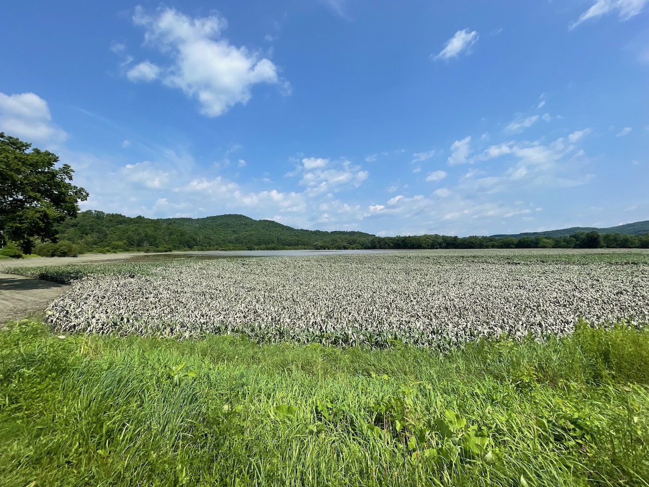 Retreating flood waters reveal silt-covered corn in the Farr Family Farm fields in Richmond
Morning Observation:
This morning in North Hero at 7:00AM it’s currently 68 degrees and raining lightly under overcast skies. Winds are out of the south at 5-7 mph. Relative humidity is 90%, dewpoint 65, barometric pressure 29.83”.Yesterday’s high was 84, and yesterday’s low was 69.
This morning in Huntington it’s currently 63 degrees and raining lightly under overcast skies. Winds are calm. Relative humidity is 98%, dewpoint 63, barometric pressure 29.87”. We picked up 0.01” of rain so far today. Yesterday’s high was 83, and yesterday’s low was 59.
There is a Flood Watch in effect for Huntington and other parts of Vermont from 2:00PM this afternoon until 2:00AM tonight.
Forecast Discussion:
Low pressure over Lake Erie this morning is lifting a warm front through the region at this hour with some light showers in attendance. This low is expected to move eastward during the day today bringing more widespread showers and thunderstorms to Vermont later this afternoon and into tonight. Some of these storms have the potential to be strong to severe. The NWS is evening bandying the word “tornado” as a possibility as some supercell storms may develop this evening, so do keep paying attention! Unsettled conditions will persist through the weekend with chances for daily showers and thunderstorms as a low pressure system camped out over Hudsons Bay rotates a series of troughs through the weekend and into next week.
3-Day Forecast:
We’ll see mostly cloudy skies today with showers and thunderstorms likely, mainly after 5:00PM. Highs will be near 82 with south winds 5-15 mph. Chance of precipitation is 70% with rainfall amounts between 0.25″-0.50″ possible. Tonight should be cloudy with showers and thunderstorms. Some storms could be severe, with large hail, damaging winds, and heavy rain. Lows will be around 65 with south winds 8-15 mph. Chance of precipitation is 80% with rainfall amounts between 0.10″-0.25″ with higher amounts possible in thunderstorms.
Friday should be partly sunny with 50% chance of showers and thunderstorms. Highs will be near 81 with south winds around 6 mph becoming northwesterly in the afternoon. Rainfall rainfall amounts between 0.25″-0.50″ are possible. Friday night should be mostly cloudy with showers and thunderstorm. Lows will be around 66 with southeast winds around 5 mph becoming light and variable in the evening. Chance of precipitation is 60% with rainfall amounts of less than 0.10″ with higher amounts possible in thunderstorms.
Saturday should be mostly sunny with a 30% chance of afternoon showers and thunderstorms. Highs will be near 84 with south winds 3-9 mph. Saturday night should be mostly cloudy with a 40% chance of showers and thunderstorms. Lows will be around 68 with south winds 7-11 mph. Rainfall amounts between 0.10″-0.25″ are possible with higher amounts possible in thunderstorms.
Almanac:
Last year on this date in Huntington we had a high of 80 and a low of 60.
Last year in North Hero we had a high of 80 and a low of 65.
Burlington averages for this date are a low of 63 and a high of 83.
The record low was 48 in 1971.
The record high was 96 in 1995.
The Lake Champlain lake level in Burlington is 97.71′ (that’s another 6″ higher than this time yesterday.)
The water temperature is 73˚.
Last year’s lake level was at 95.41′.
Sky Notes:
Sunrise: 5:20AM
Sunset: 8:34PM
Length of day: 15:14:46
Today will be 1:26 shorter than yesterday.
The Moon is a waning crescent, 25 days old with 18% illumination.
Moonrise: 1:39AM
Moonset: 5:35PM
About Today’s Photo:
I grabbed this shot as I passed the Farr Family Farm bottomland fields in Richmond yesterday morning. You can clearly see how far the flood waters extended across the floodplain, and the receding water has left behind a corn crop covered in fine grey silt.
iPhone 12 Pro
Wednesday, July 12, 2023

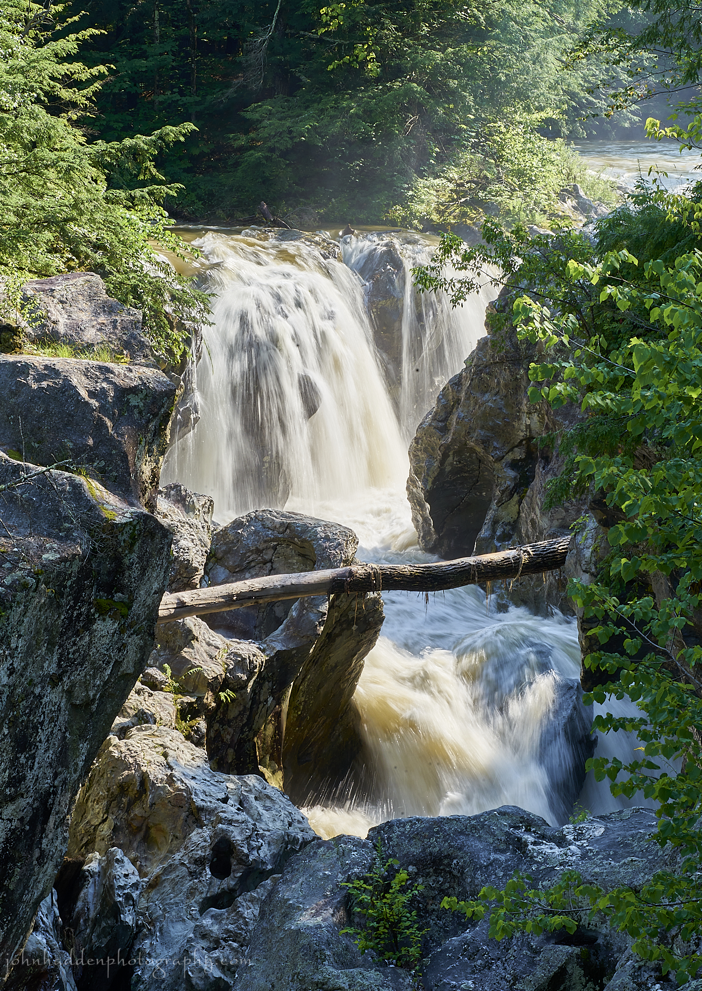 Water pours over Huntington Gorge yesterday afternoon
Morning Observation:
This morning in Huntington at 7:00AM it’s currently 64 degrees under mostly cloudy skies. Winds are calm. Relative humidity is 98%, dewpoint 63, barometric pressure 29.88”. We picked up a total of 1.13” of rain yesterday (5.21” for the 3-day storm total). Yesterday’s high was 85, and yesterday’s low was 65. The overnight low got down to 60.
This morning in North Hero it’s currently 70 degrees under mostly cloudy skies. Winds are out of the south at 2-4 mph. Relative humidity is 93%, dewpoint 68, barometric pressure 29.83”. We picked up 0.79” of rain yesterday (2.74” for the 3-day storm total), and we’ve picked up 0.05” of rain so far today. Yesterday’s high was 80, and yesterday’s low was 66. The overnight low got down to 69.
Forecast Discussion:
Low pressure spinning over Hudsons Bay will influence our weather for the next several days and heading into the weekend. The low will swing a weak cold front down from Québec today bringing some scattered showers and afternoon thunderstorms to the region today. A trough of low pressure is expected to move through the region on Thursday with a warm front living through Thursday morning followed by a cold front in the evening. Scattered showers and afternoon thunderstorms are expected to accompany the cold font as it moves through. Unsettled conditions will persist through the weekend as we once again (and again and again) fall under blocked, large upper level cyclonic circulation that will keep showers and afternoon thunderstorms in the picture into early next week. Seems we can’t catch a break this summer…
3-Day Forecast:
We’ll see partly sunny skies today with a slight chance of morning showers and thunderstorms, then a slight chance of afternoon showers and thunderstorms. Highs will be near 83 with southwest wind 5-7 mph becoming northwesterly in the afternoon. Tonight should be partly cloudy with a low around 61 and light and variable winds.
Thursday should be cloudy with a slight chance of morning showers, then a 50% chance of showers and thunderstorms in the afternoon. Highs will be near 81 wit south winds 5-9 mph. Rainfall amounts of less than 0.10″ are possible with higher amounts possible in thunderstorms. Thursday night should be cloudy with showers and thunderstorms. Lows will be around 66 with south winds 10-14 mph. Chance of precipitation is 90% with rainfall amounts between 0.10″-0.25″ possible.
Friday should be cloudy with an 80% chance of showers and thunderstorms. Highs will be near 82 with south winds around 10-13 mph. Rainfall amounts between 0.25″-0.50″ are possible. Friday night should be cloudy with showers and thunderstorm. Lows will be around 66 with south winds 3-7 mph. Chance of precipitation is 80% with rainfall amounts between 0.10″-0.25″ possible with higher amounts possible in thunderstorms.
Almanac:
Last year on this date in Huntington we had a high of 84 and a low of 61. We picked up 0.15″ of rain.
Last year in North Hero we had a high of 83 and a low of 67. We picked up 0.27″ of rain.
Burlington averages for this date are a low of 63 and a high of 83.
The record low was 46 in 1971.
The record high was 96 in 1948.
The Lake Champlain lake level in Burlington is 97.22′ (up nearly 9″ since yesterday morning!)
The water temperature is 75˚.
Last year’s lake level was at 95.48′.
Sky Notes:
Sunrise: 5:19AM
Sunset: 8:35PM
Length of day: 15:16:13
Today will be 1:23 shorter than yesterday.
The Moon is a waning crescent, 24.4 days old with 27% illumination.
Moonrise: 1:12AM
Moonset: 4:21PM
About Today’s Photo:
By the time I made it to Huntington Gorge yesterday afternoon, it was evident that the river’s water level had dropped a good 1′-2′ feet from its high probably sometime overnight or early Tuesday morning. Now all that water is moving through Richmond and downstream into Lake Champlain were the lake level is rising dramatically (nearly 9″ since yesterday morning!)
Sony A7II, Sony 24-240mm lens @ 103mm, ISO 100, f/32, 1/13″ exposure.
Tuesday, July 11, 2023

 The view from our porch for much of the day yesterday
Morning Observation:
This morning in North Hero at 7:00AM it’s currently 67 degrees under overcast skies. Winds are calm, and the rains have just stopped. Relative humidity is 99%, dewpoint 66, barometric pressure 29.77”. We picked up a 1.81” of rain yesterday and 0.76” so far today. Rain total for the storm (so far) is 2.71”. Yesterday’s high was 71, and yesterday’s low was 67. The overnight low got down to 66.
This morning in Huntington it’s currently 65 degrees and still raining under overcast skies. Winds are calm. Relative humidity is 98%, dewpoint 65, barometric pressure 29.80”. We picked up 3.46” of rain yesterday and 1.13” so far today. Rain total for the storm (so far) is 5.21”. Yesterday’s high was 68, and yesterday’s low was 65. The overnight low got down to 65.
A Flood Warning remains in effect for Huntington and North Hero through 10:30AM today, and a Flood Watch remains in effect until 8:00PM.
Forecast Discussion:
Morning radar imagery shows the center of the low responsible for this historic flooding event now near Montreal. The low is expected to continue its trek northward with showers shutting down by this afternoon across the region. Indeed, showers have already shut down here in North Hero. Main stem rivers (Missisquoi, Lamoille, Winooski, Otter Creek) are all in flood stage at this hour and are expected to continue rising through the day today and crest sometime this afternoon. There are lots of road closures across the region. A good source for State road closure information is at www.newengland511.org. Note that this only includes State roads—there are many, many local road closures as well. Looking at the CoCoRaHS map, the big rainfall “winners” over the past 3 days of the event are Woodbury at 7.37″, Greensboro at 7.33″, and Middlesex at 7.21″. Rochester is reporting 5.92″ with 6.02″ in West Dover. And it’s still raining at this hour in all of those locations.
High pressure is expected to build in later this afternoon drying things out and bringing some sunshine west to east along with seasonably muggy conditions expected later today and into Wednesday. More rain is in the forecast, however, as low pressure over Hudsons Bay swings a series of shortwave troughs through the region midweek onward. We can expect showers and afternoon thunderstorms to crop back up Wednesday night into Thursday, and again on Friday. While we’re not talking about a lot of rain in any of these events, the already waterlogged soils will cause trouble for areas already effected by flooding. Unsettled conditions are expected to continue into the weekend.
3-Day Forecast:
We’ll see mostly cloudy skies today with showers before noon. Highs will be near 84 with west winds 6-10 mph. Chance of precipitation is 80% with rainfall amounts between 0.10″-0.25″. Tonight should be partly cloudy with a low around 63 and south winds 5-10 mph.
Wednesday should be mostly sunny with a slight chance of afternoon showers. Highs will be near 84 with southwest winds 6-8 mph. Wednesday night should be mostly cloudy with a low around 62 and light and variable winds.
Thursday should be mostly cloudy with a 60% chance of afternoon showers and thunderstorms. Highs will be near 80 with south winds 5-10 mph. Chance of precipitation is 60% with rainfall amounts between 0.10″-0.25″ with higher amounts possible in thunderstorms. Thursday night should be cloudy with showers and thunderstorms likely.Lows will be around 65 with southeast wind 5-8 mph. Chance of precipitation is 80% with rainfall amounts between 0.10″-0.25″ with higher amounts possible in thunderstorms.
Almanac:
Last year on this date in Huntington we had a high of 84 and a low of 50.
Last year in North Hero we had a high of 83 and a low of 66.
Burlington averages for this date are a low of 62 and a high of 83.
The record low was 48 in 1977.
The record high was 94 in 1948.
The Lake Champlain lake level in Burlington is 96.51′ (up quite a bit from yesterday and expected to rise further…)
The water temperature is 67˚.
Last year’s lake level was at 95.54′.
Sky Notes:
Sunrise: 5:18AM
Sunset: 8:36PM
Length of day: 15:17:36
Today will be 1:19 shorter than yesterday.
The Moon is a waning crescent, 23.4 days old with 37% illumination.
Moonrise: 12:49AM
Moonset: 3:11PM
About Today’s Photo:
The view south from our porch here in North Hero yesterday was a study in grays. With calm winds and occasionally heavy downpours, the surface of the lake took on an interesting mottled pattern.
iPhone 12 Pro
Monday, July 10, 2023

 A black swallowtail at Alburgh Dunes State Park
Morning Observation:
This morning in North Hero at 7:05AM it’s currently 69 degrees and raining lightly under overcast skies. Winds are out of the southeast at 3-5 mph. Relative humidity is 96%, dewpoint 68, barometric pressure 29.79”. We picked up 0.14” of rain yesterday and 0.15” so far today. Yesterday’s high was 81, and yesterday’s low was 67. The overnight low got down to 68.
This morning in Huntington it’s currently 65 degrees and raining steadily under overcast skies. Winds are calm. Relative humidity is 97%, dewpoint 64, barometric pressure 29.79”. We picked up 0.62” of rain yesterday and 1.65” so far today. Yesterday’s high was 84, and yesterday’s low was 63, The overnight low got down to 65.
There is a Flash Flood Warning in effect for Huntington until 8:00AM this morning.
Forecast Discussion:
Morning radar imagery shows deep moisture over the region, and the NWS reports that we are on track to unfortunately meet the highest predictions of rainfall, especially over the spine of the Greens and southern Vermont. As much as 7″ of rain may fall along the spine of the Greens today with 5″-7″ likely in other warning areas. Numerous Flash Flood Warnings (not just Watches!) have been posted for many locations in Vermont including Huntington, so please take them seriously! Rain will persist throughout the day today and into Tuesday before finally winding down Tuesday late afternoon. An active weather pattern is expected for the rest of the week, however, as an upper level low takes up residence over Hudson Bay and rotates a series of troughs through the North Country. While not a washout any particular day, chances for showers will exist each day heading into next weekend. Temperatures are expected to remain seasonably muggy through the period. This seems to be out lot this summer…
3-Day Forecast:
We’ll see cloudy skies today with rain and afternoon thunderstorms possible. Some of the storms could produce heavy rainfall. Highs will be near 72 with east winds 5-7 mph. Chance of precipitation is 100% with rainfall amounts between 3″-4″ possible in Huntington and 1″-2″ in North Hero. Tonight should be cloudy with rain. The rain could be heavy at times. Lows will be around 62 with southwest winds 5-8 mph. Chance of precipitation is 80% with rainfall amounts between 1″-2″ possible in Huntington and North Hero.
Tuesday should be cloudy with rain and thunderstorms before 4:00PM. Some of the storms could produce heavy rainfall. High near 82. West wind around 7 mph. Chance of precipitation is 80%. New rainfall amounts between 0.25″-0.50″ are possible. Tuesday night should be partly cloudy with a low around 64 and southwest winds 7-9 mph.
Wednesday should be mostly sunny with a 40% chance of showers and thunderstorms. Highs will be near 82 with southwest winds 5-9 mph. Rainfall amounts of less than 0.10″ are possible with higher amounts possible in thunderstorms. Wednesday night should be mostly cloudy with a low around 62 and southwest winds 3-6 mph.
Almanac:
Last year on this date in Huntington we had a high of 80 and a low of 43.
Last year in North Hero we had a high of 79 and a lo low of 58.
Burlington averages for this date are a low of 62 and a high of 83.
The record low was 45 in 1954.
The record high was 95 in 2020 (we had a high of 89 in Huntington).
The Lake Champlain lake level in Burlington is 96.23′.
The water temperature is 77˚.
Last year’s lake level was at 95.59′.
Sky Notes:
Sunrise: 5:17AM
Sunset: 8:36PM
Length of day: 15:18:56
Today will be 1:16 shorter than yesterday.
The Moon is a waning crescent, 22 days old with 47% illumination.
Moonrise: 12:29AM
Moonset: 1:58PM
About Today’s Photo:
I came across this (and another) black swallowtail at the head of the “trail” to the old commercial campground section of Alburgh Dunes State Park. The pair was quite attracted to something in a pile of topsoils that was next to a newly constructed home by the shore. You’ll often see butterflies of various species attracted to minerals in soils and even roads where the remnants of winter road salts still exist.
Sony A7II, Sony 24-240mm lens @ 240mm, ISO 1250, f/8, 1/1600″ exposure
Sunday, July 9, 2023

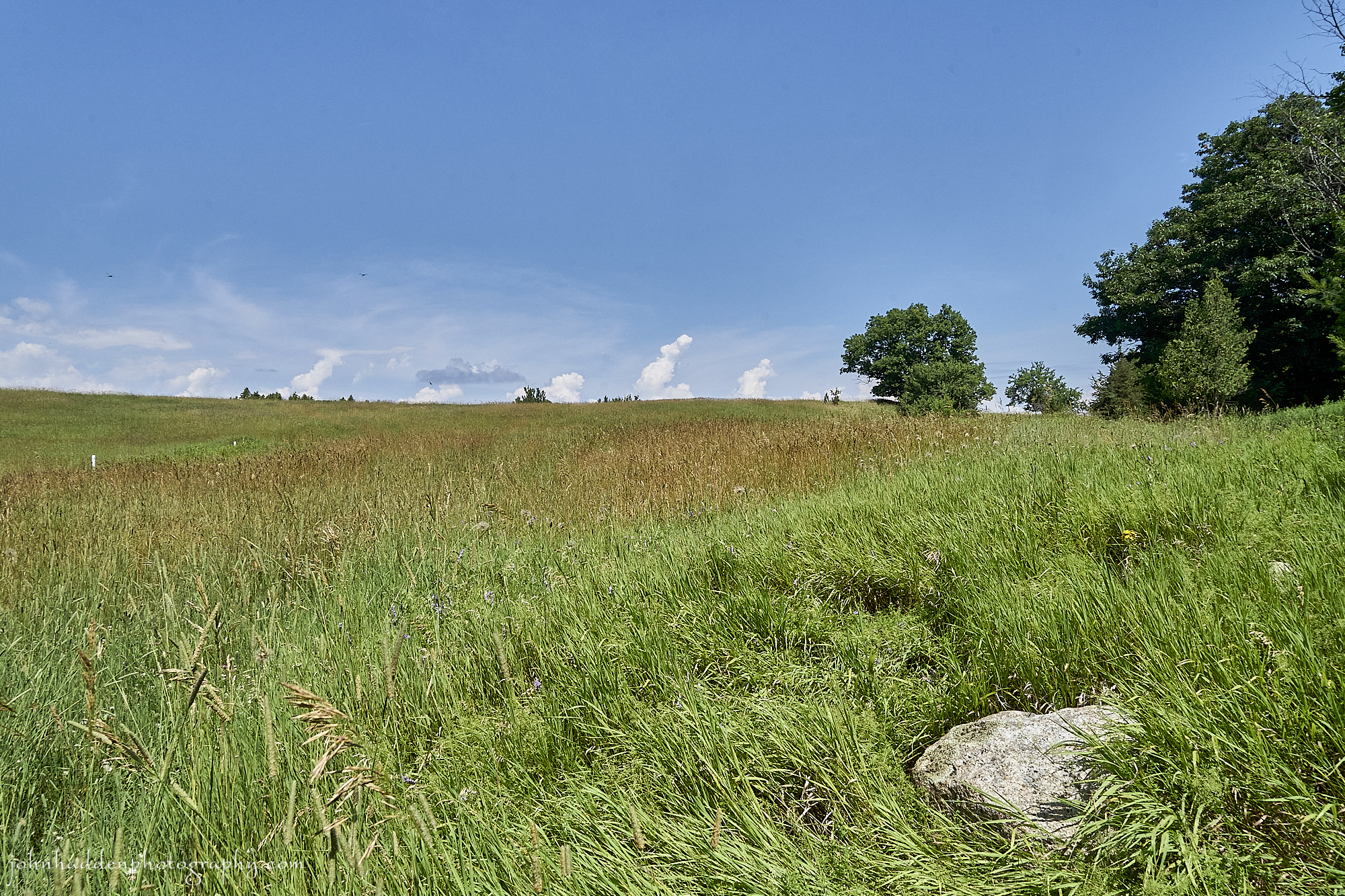 A high summer meadow near the Alburgh Dunes
Morning Observation:
This morning in North Hero at 7:25AM it’s currently 72 degrees under partly cloudy skies. Winds are calm. Relative humidity is 88%, dewpoint 68, barometric pressure 29.80”. We picked up 0.05” of rain yesterday evening as a series of thunderstorms rolled through. Yesterday’s high was 84, and yesterday’s low was 70. The overnight low got down to 67.
This morning in Huntington it’s currently 69 degrees under partly cloudy skies. Winds are calm. Relative humidity is 98%, dewpoint 68, barometric pressure 29.83”. Yesterday’s high was 88, and yesterday’s low was 60. The overnight low got down to 63.
There is a Flood Watch in effect for our region from 2:00PM today until 8:00PM Monday.
Forecast Discussion:
We’ve got the quiet before the storm this morning as we’re on the verge of a very impactful rainfall event that will be moving into the region this afternoon. Moisture laden low pressure moving out of the Tennessee River valley is expected to track northward during the day today bringing widespread soaking rains. Showers should move into the region this afternoon with rain becoming heavy overnight tonight and again on Monday as the aforementioned low tracks directly over the region Monday. The NWS has some pretty dire language in their forecast discussion with the North Country “under risk for flash flooding on a scale that has not been seen in many years.” Washouts, damage to culverts, and potential mudslides are discussed, and we are urged to take this storm seriously. The low is expected to lift northward out of the region Monday night into early Tuesday with wrap-around showers expected Tuesday. High pressure is expected to build back in later on Tuesday, but we’ll remain in an active weather pattern as the aforementioned low lingers over Hudson Bay rotating in a series of troughs into the region through midweek.
3-Day Forecast:
We’ll see mostly cloudy skies today with showers and thunderstorms likely this afternoon. Some of the storms could produce gusty winds and heavy rain. Highs will be near 82 with south winds around 5 mph. Chance of precipitation is 60% with rainfall amounts between 0.25″-0.50″ possible. Tonight should be cloudy with showers and possibly a thunderstorm before 8:00PM, then rain overnight. Some of the storms could produce heavy rainfall. Lows will be around 65 with southeast winds 3-6 mph. Chance of precipitation is 100% with rainfall amounts between 1″-2″ possible.
Monday should be cloudy with rain and afternoon thunderstorms. Some of the storms could produce heavy rain. Highs will be near 74 with calm winds. Chance of precipitation is 90% with rainfall amounts between 1″-2″ possible. Monday night should be cloudy with showers. Lows will be around 63 with west winds 8-10 mph. Chance of precipitation is 90% with rainfall amounts between 1″-2″ possible.
Tuesday should be mostly cloudy with showers likely, mainly before 9:0AM. Highs will be near 82 with southwest winds around 6 mph. Chance of precipitation is 60% with rainfall amounts between 0.50”-0.75” possible. Tuesday night should be partly cloudy with a low around 65 and south winds 5-8 mph.
Almanac:
Last year on this date in Huntington we had a high of 72 and a low of 45.
Last year in North Hero we had a high of 73 and a low of 55.
Burlington averages for this date are a low of 62 and a high of 82.
The record low was 44 in 1969.
The record high was 97 in 1988.
The Lake Champlain lake level in Burlington is 96.15′.
The water temperature is 77˚.
Last year’s lake level was at 95.68′.
Sky Notes:
Sunrise: 5:16AM
Sunset: 8:37PM
Length of day: 15:20:12
Today will be 1:12 shorter than yesterday.
The Moon is in its last quarter, 21 days old with 58% illumination.
Moonrise: 12:09AM
Moonset: 12:45PM
About Today’s Photo:
We went for a walk on a piece of property recently added to the Alburgh Dunes State Park. The property includes an abandoned lakefront campground with crumbling buildings and the remnants of camping sites scattered about. Last year, there was a trail mowed through the property, but not this year. Part of the property includes broad meadows that have been left untended and offer some splendid habitat for a variety of species. We liked this view of one of the meadows with cumulous clouds building over the horizon.
Sony A7II, Sony 24-240mm lens @ 24mm, ISO 800, f/14, 1/800″ exposure.
Saturday, July 8, 2023

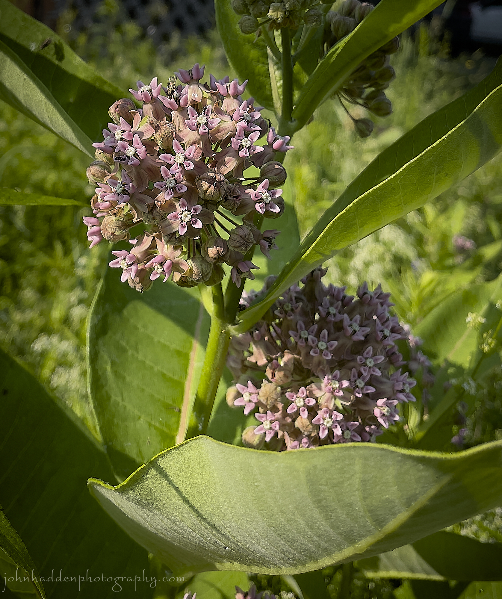 Milkweed blooming in our field in Huntington
Morning Observation:
This morning in North Hero at 7:35AM it’s currently 71 degrees under partly cloudy/foggy skies. Winds are out of the south at 6-8 mph. Relative humidity is 97%, dewpoint 70, barometric pressure 29.84”. We picked up 0.20” of rain yesterday. Yesterday’s high was 84, awl 70. The overnight low got down to 71.
This morning in Huntington it’s currently 67 degrees under partly cloudy skies. Winds are calm. Relative humidity is 99%, dewpoint 67, barometric pressure 29.87”. We picked up 0.13” of rain yesterday. Yesterday’s high was 86, and yesterday’s low was 67. The overnight low got down to 60.
Forecast Discussion:
We’ve got a fairly pleasant day on tap for today. Valley fog should to burn off by midmorning with partly to mostly sunny skies and highs in the low to mid 80s expected. By this afternoon, convection should go to work with some scattered pop-up showers and thunderstorms possible. A weak shortwave will lift through the region tonight keeping the chance of showers overnight. After a dry start to the day Sunday, more rain returns. Low pressure moving out of the Great Lakes Sunday night and a moisture-laden warm front lifting from the south into the region Sunday night into Monday will combine to bring widespread heavy rains and thunderstorms. Showers should move into Vermont Sunday afternoon and persist through Monday. There’s quite a lot of moisture in this system, so flash flooding will be a concern once again. Stay tuned…
3-Day Forecast:
We’ll see mostly sunny skies today with scattered showers and thunderstorms this afternoon. Some of the storms could produce heavy rain. Highs will be near 84 with light and variable winds. Chance of precipitation is 30%. Tonight should be mostly cloudy with scattered showers and thunderstorms. Lows will be around 66 with light southwest winds. Chance of precipitation is 40% with rainfall amounts between 0.10″-0.25″, with higher amounts possible in thunderstorms.
Sunday should be mostly cloudy with scattered showers and thunderstorms, mainly after 2:00PM. Some of the storms could produce heavy rain. Highs will be near 82 with south winds around 6 mph. Chance of precipitation is 50% with rainfall amounts between 0.10″-0.25″, with higher amounts possible in thunderstorms. Sunday night should be cloudy withs showers and possibly a thunderstorm. Some of the storms could produce heavy rain. Lows will be around 65 with southeast winds 6-10 mph. Chance of precipitation is 90% with rainfall amounts between 0.75”-1” possible.
Monday should be cloudy with showers likely. The rain could be heavy at times. Highs will be near 77 with southeast winds 8-14 mph. Chance of precipitation is 70% with rainfall amounts between 1″-2″ are possible. Monday night should be mostly cloudy with a 50% chance of showers. Lows will be around 62 with southwest winds 5-7 mph. Rainfall amounts between 1″-2″ are possible.
Almanac:
Last year on this date in Huntington we had a high of 81 and a low of 51.
Last year in North Hero we had a high of 81 and a low of 64.
Burlington averages for this date are a low of 62 and a high of 82.
The record low was 40 in 1969.
The record high was 97 in 1988.
The Lake Champlain lake level in Burlington is 96.09′
The water temperature is 76˚.
Last year’s lake level was at 95.73′.
Sky Notes:
Sunrise: 5:16AM
Sunset: 8:37PM
Length of day: 15:21:25
Today will be 1:08 shorter than yesterday.
The Moon is waning gibbous, 20 days old with 69% illumination.
No Moonrise
Moonset: 11:29AM
About Today’s Photo:
Another high summer flower—milkweed—is blooming in our front field in Huntington. These complex compound flower heads are a haven for pollinators as well as the primary source of food for monarch butterflies. A good crop of milkweed is a good thing to see!
iPhone 12 Pro
Friday, July 7, 2023

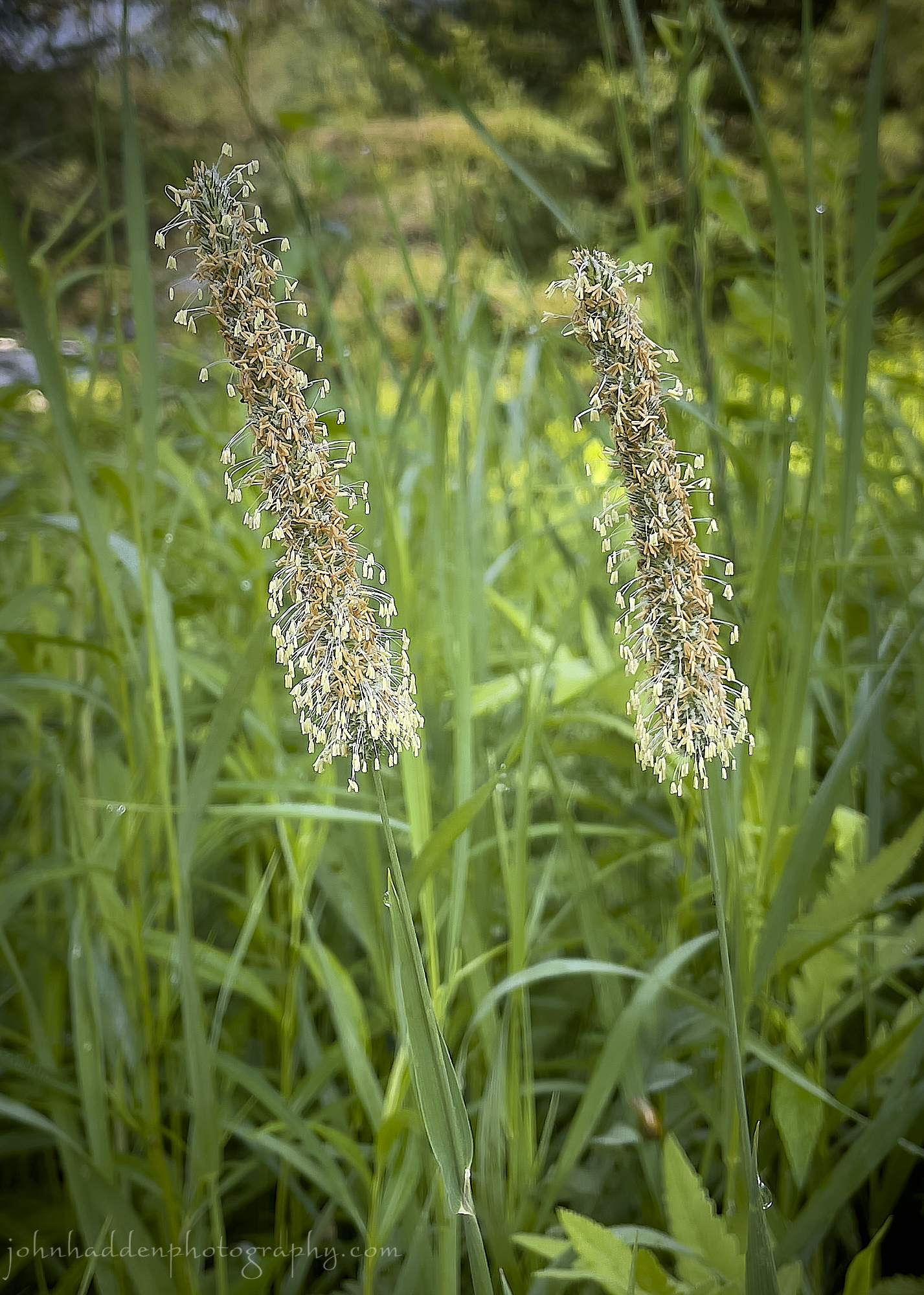 Timothy grass booming in Huntington
Morning Observation:
This morning in North Hero at 7:10AM it’s currently 76 degrees under partly cloudy skies. Winds are out of the south at 3-5 mph. Relative humidity is 85%, dewpoint 71, barometric pressure 29.79”. Yesterday’s high was 85, and yesterday’s low was 73. The overnight low got down to 73.
This morning in Huntington it’s currently 72 degrees under partly cloudy skies. Winds are calm. Relative humidity is 95%, dewpoint 70, barometric pressure 29.82”. Yesterday’s high was 91, and yesterday’s low was 66. The overnight low got down to 67.
Forecast Discussion:
We’ve got an active day of weather ahead of us with a welcome (by me anyway…) break in the heat! Morning radar imagery shows a line of scattered showers extending southwest to northeast just about over Ottawa at this hour. These showers are out ahead of a frontal boundary which is expected to move into Vermont by this afternoon bringing widespread showers and thunderstorms the afternoon and evening. As the front washes out tonight, widespread fog is expected to form in valley locations, but also extending beyond the usual places. Unsettled but generally cooler conditions will continue into Saturday with pop-up scattered showers expected during the afternoon. A more potent low pressure system is expected to move into the region Sunday afternoon bringing and extended period of rain and afternoon thunderstorms Sunday afternoon and through the day on Monday. Unsettled conditions once again look to be in place heading into the middle of next week.
3-Day Forecast:
We’ll see partly sunny skies today with showers and thunderstorms this afternoon and evening. Some of the storms could produce small hail, gusty winds, and heavy rain. Highs will be near 85 with south winds 6-9 mph becoming westerly in the afternoon. Chance of precipitation is 80% with rainfall amounts between 0.25″-0.50″ possible. Tonight should be mostly cloudy with showers and thunderstorms, mainly before 11:00PM. Some of the storms could produce small hail, gusty winds, and heavy rain. Lows will be around 67 with light south winds. Chance of precipitation is 80% with rainfall amounts between 0.10″-0.25″, except higher amounts possible in thunderstorms.
Saturday should be partly sunny with a 40% chance of afternoon showers and thunderstorms. Highs will be near 83 with light and variable winds. Saturday night should be mostly cloudy with a 30% chance of showers and thunderstorms. Lows will be around 67 with south winds 3-6 mph.
Sunday should be mostly cloudy chance of showers before noon, then showers likely and possibly a thunderstorm in the afternoon. Highs will be near 81 with south winds 5-10 mph. Chance of precipitation is 60% with rainfall amounts between 0.25″-0.50″ possible. Sunday night should be cloudy with rain likely. The rain could be heavy at times. Lows will be around 64 with south winds 3-6. Chance of precipitation is 70% with rainfall amounts between 1″-2″ possible in Huntington and 0.75”-1” in North Hero.
Almanac:
Last year on this date in Huntington we had a high of 81 and a low of 49.
Last year in North Hero we had a high of 76 and a low of 59.
Burlington averages for this date are a low of 62 and a high of 82.
The record low was 43 in 1969.
The record high was 95 in 2010 (we had a high of 94 in Huntington).
The Lake Champlain lake level in Burlington is 96.11′.
The water temperature is 77˚.
Last year’s lake level was at 95.76′.
There’s been a lot of discussion of late about Cyanobacteria blooms in Lake Champlain. With recent (and expected…) heavy rainfall, hot temperatures, and light winds, conditions have been unfortunately perfect for widespread algae blooms around the lake with subsequent beach closures in the Burlington area. I’ve noted that the lake temperature is a good 10˚ warmer this year than it was at this time last year.
You can read about Cyanobacteria here and follow the monitoring of Cyanobacteria conditions here.
Sky Notes:
Sunrise: 5:15AM
Sunset: 8:38PM
Length of day: 15:22:33
Today will be 1:04 shorter than yesterday.
The Moon is waning gibbous, 19 days old with 80% illumination.
Moonrise: 11:49PM
Moonset: 10:11AM
About Today’s Photo:
As we approach high summer, the grasses in our front field in Huntington are in bloom. I caught these Timothy seed heads just at the perfect time yesterday as the tiny flowers had just emerged. A light tap on the top and little plumes of pollen drift in the air!
iPhone 12 Pro
