Wednesday, January 31, 2024
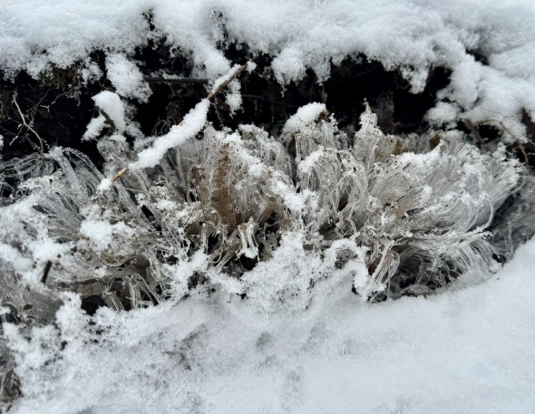 Delicate needle ice along the trail at CHNSA
Morning Observation:
This morning in Huntington at 8:00AM it’s currently 29 degrees under cloudy skies. Winds are calm. Th is 90%, dewpoint 27, barometric pressure 30.10”. We have 5” of snow at the stake. Yesterday’s high was 30, and yesterday’s low was 25. The overnight low got down to 29.
This morning in North Hero it’s currently 30 degrees under cloudy skies. Winds are calm. Relative humidity is 92%, dewpoint 28, barometric pressure 30.15”. Yesterday’s high was 27, and yesterday’s low was 20. The overnight low got down to 24.
Forecast Discussion:
High pressure slipping to our east today will bring in a light southerly airflow allowing temperatures to warm into the mid 30s today under cloudy skies. A weak, moisture-starved clipper low will skirt to our north during the day on Thursday bringing some chances of precipitation. We’ll likely see snow at the onset Thursday mid-morning, mixing with or changing over to rain midday as temperatures rise into the upper 30s, then light snow overnight into Friday morning. Impacts are expected to be minimal if anything with highest precipitation amounts expected over northern west-facing mountains and near the international border. An extended period of dry and seasonable weather is expected heading into the weekend with maybe even some sunshine returning by Sunday into next week.
3-Day Forecast:
We’ll see cloudy skies today with a high near 35 and south winds 5-10 mph. Tonight should be cloudy with a low around 29 and south winds 8-15 mph.
Thursday should be cloudy with a 40% chance of snow showers after 10:00AM, mixing with rain after 1:0PM. Highs will be near 37 with southwest winds 8-14 mph. Little or no snow accumulation is expected. Thursday night should be cloudy with a 50% chance of snow showers. Lows will be around 25 with calm winds becoming northwesterly around 5 mph after midnight. New snow accumulations of less than 0.50″ are possible.
Friday should be cloudy with a 50% chance of snow showers. Highs will be near 29 with north winds 9-13 mph. New snow accumulations of less than 0.50″ are possible. Friday night should be mostly cloudy with a 30% chance of snow showers. Lows will be around 14 with north winds 8-11 mph.
Almanac:
Last year on this date in Huntington we had a high of 21 and a low of 2. We picked up 3.2″ of new snow and had 10″ at the stake.
Last year in North Hero we had a high of 24 and a low of 10. We picked up 1″ of new snow and had 7″ at the stake.
Burlington averages for this date are a low of 12 and a high of 29.
The record low was -20 in 198.
The record high was 56 in 2013 (we had a high of 55 in Huntington).
The Lake Champlain lake level in Burlington is 97.72′.
The water temperature is 37˚.
Last year’s lake level was at 96.69′.
The Mt. Mansfield snow stake depth is 48″.
The average depth for this date is 51″.
Mt. Washington Summit Conditions
Current Temperature: 17˚
Winds are out of the NW at 22 mph
24 hr Precipitation: 0
Visibility: around 70 miles
Sky Notes:
Sunrise: 7:11AM
Sunset: 4:59PM
Length of day: 9:47:50
Today will be 2:27 longer than yesterday.
The Moon is waning gibbous, 19.8 days old with 74% illumination.
Moonrise: 11:02PM
Moonset: 9:43AM
About Today’s Photo:
I came across this needle ice while skiing up at Camel’s Hump Nordic yesterday morning. Needle ice forms when damp, slightly-warmer-than-freezing soils are exposed to cold air. The moisture, instead of being absorbed by the soil, is drawn upward through capillary action to create elongated ice crystals. This is some of the most delicate needle ice I’ve seen in recent years . Lovely!
iPhone 15 Pro

Leave a comment