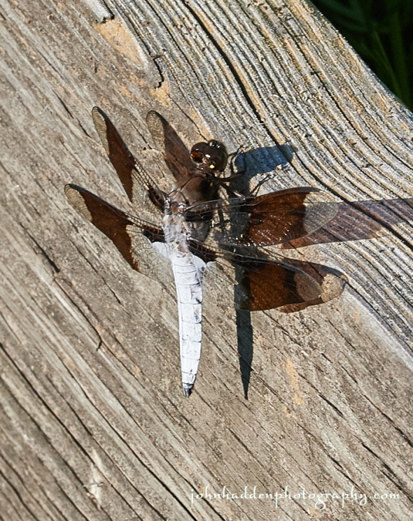
Thursday, August 31, 2017


A spotted spreadwing by the pond
Morning Observation:
This morning in Huntington at 7:00AM it’s currently 53 degrees under overcast skies. Winds are calm. Relative humidity is 99%, dewpoint 53, barometric pressure 29.84” and steady. We picked up a 0.01” trace of rain overnight. Yesterday’s high was 74, and the overnight low was 45.
Forecast:
A strong cold front will swing across the region today bringing low clouds and scattered light rain showers, mainly this morning. A northwesterly air flow will deliver cooler, fall-like temperatures for tonight and Friday with highs on Friday ranging from the mid 50s to lower 60s with continued gusty northwest winds. Lows Friday night will dip into the mid 30s in some locations with a slight possibility of frost in the traditional cold pockets. High pressure building into the region Saturday will bring lighter winds and warmer temperatures, with highs rebounding to around 70 degrees. A shortwave trough moving out of the Great Lakes Sunday will combine with the remnants of tropical Storm Harvey to deliver widespread showers during the daylight hours on Sunday.
We’ll see mostly cloudy skies today with a 50% chance of showers, mainly this morning. Highs will be in the lower 60s with northwest winds 10 to 15 mph. Tonight should be mostly cloudy until midnight, then become partly cloudy. Lows will be around 40 with northwest winds 10 to 15 mph.
Friday should be partly sunny with highs only in the mid 50s and northwest winds 15 to 20 mph gusting up to 30 mph. Friday night should be mostly clear and chilly with lows in the mid 30s to 40 with northwest winds 10 to 15 mph.
Saturday’s looking sunny and milder with highs in the upper 60s and light and variable winds. Saturday night should be partly cloudy with a 50% chance of showers. Lows will be in the upper 40s.
Almanac:
Last year on this date we had a high of 77 and a low of 61. We picked up 0.20″ of rain.
Burlington averages for this date are highs of 76 and lows of 56.
The record high was 92°F in 2010 (we had a high of 89.)
The record low was 35°F in 1965.
Sky Notes:
Sunrise: 6:13 AM EDT
Sunset: 7:29 PM EDT
Length of Visible Light: 14h 15m
Length of Day: 13h 15m
Tomorrow will be 2m57s shorter.
The Moon is waxing gibbous, 9.1 days old with 68% illumination.
Moonrise: 3:56 PM EDT
Moonset: 12:47 AM EDT
About Today’s Photo:
A spotted spreadwing dragonfly perches briefly on a reed along the shore of our pond. Thanks once again to Wally Jenkins for the ID!
Nikon D600, Sigma 105mm macro lens, ISO 800, f/3.3, 1/2500″ exposure.
Wednesday, August 30, 2017

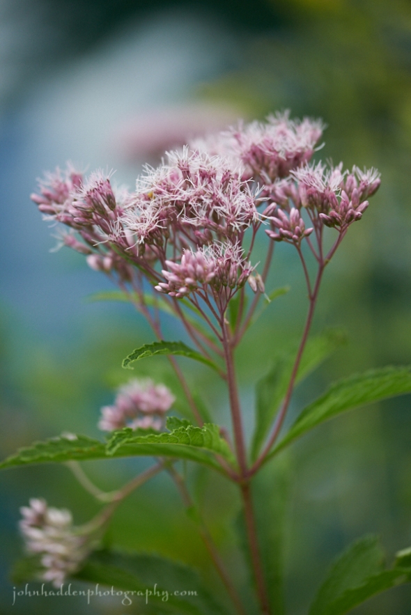
Joe Pye weed flowering by the pond
Morning Observation:
This morning in Huntington at 7:30AM it’s currently 51 degrees under partly cloudy skies. Winds are calm. Relative humidity is 98%, dewpoint 50, barometric pressure 30.01” and steady. Yesterday’s high was 69, and the overnight low was 49.
Forecast:
We’ve got one more day of dry albeit cloudy weather before a cold front moves into the region Thursday bringing scattered to numerous showers. Colder air will follow in behind the front on Friday with below normal temperatures expected. Warmer and drier weather is expected for Saturday before another front moves in on Sunday bringing more rain.
We’ll see partly sunny skies this morning, then clearing. Highs will be in the lower 70s with light and variable winds. Tonight should be mostly clear with a slight chance of showers after midnight. Lows will be in the lower 50s with light and variable winds. Chance of rain is 20%.
Thursday showers are likely. Highs will only be in the lower 60s with light and variable winds. Chance of rain is 70%. Thursday night should be mostly cloudy with lows in the lower 40s and light and variable winds.
Friday’s looking partly sunny and fall-like with highs only in the upper 50s. Friday night should be mostly clear with lows in the lower 40s.
Almanac:
Last year on this date we had a high of 75 and a low of 50.
Burlington averages for this date are highs of 77 and lows of 56.
The record high was 93°F in 1991.
The record low was 39°F in 1965.
Sky Notes:
Sunrise: 6:12 AM EDT
Sunset: 7:31 PM EDT
Length of Visible Light: 14h 18m
Length of Day: 13h 18m
Tomorrow will be 2m56s shorter.
The Moon is waxing gibbous, 8.2 days old with 59% illumination.
Moonrise: 3:05 PM EDT
Moonset: 12:05 AM EDT
About Today’s Photo:
Joe-Pye weed is common to our region and grows in fields between wetlands and drier goldenrod dominated areas. It’s named after Joe Pye (Jopi), a Native American healer who purportedly used the plant to cure fevers. Early American colonists also used it to treat typhus and other ailments. This late summer bloomer is a popular destination for pollinators.
Nikon D600, Sigma 105mm macro lens, ISO 800, f/3.3, 1/2500″ exposure.
Tuesday, August 29, 2017

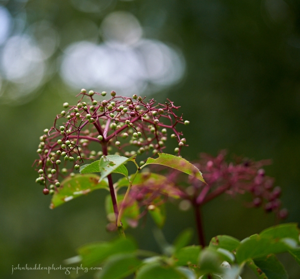
Elderberry fruiting along Fargo Brook
Morning Observation:
This morning in Huntington at 7:50AM it’s currently 53 degrees under partly cloudy skies. Winds are calm. Relative humidity is 98%, dewpoint 52, barometric pressure 30.29”. Yesterday’s high was 77, and the overnight low was 44.
Forecast:
Dry conditions and fair weather continue through midweek courtesy of high pressure currently over the northeast. Temperatures will remain seasonable until a cold front arrives Thursday bringing showers and a return to well below seasonable temperatures to end the week.
We’ll see partly sunny skies today with more clouds for this afternoon. Highs will be around 74F with SE winds at 5 to 10 mph. Tonight should be molstly cloudy with lows around 51F and light and variable winds.
Wednesday should be mostly cloudy with highs around 74F and NW winds at 5 to 10 mph. Wednesday night should be mostly clear skies early giving way to clouds and a few showers after midnight with some rumbles of thunder possible. Lows will be around 56F with light and variable winds. Chance of rain is 30%.
Thursday should bring showers in the morning, then partly cloudy skies in the afternoon. High will be around 66F with WNW winds at 10 to 15 mph. Chance of rain is 50%. Thursday night should be partly cloudy with lows around 44F and NW winds at 5 to 10 mph.
Almanac:
Last year on this date we had a high of 73 and a low of 52.
Burlington averages for this date are highs of 77 and lows of 57.
The record high was 94°F in 1952.
The record low was 39°F in 1925.
Sky Notes:
Sunrise: 6:13AM
Sunset: 7:35PM
Length of Visible Light: 14h 22m
Length of Day: 13h 22m
Tomorrow will be 2 minutes 55 seconds shorter
The Moon is in its first quarter, 7.3 days old with 50% illumination.
Moonrise: 2:11PM
No moonset
About Today’s Photo:
The bright purple stems of elderberry fruit heads certainly catch the eye this time of year. The nutritious berries are sought out by many critters including birds, bears, and homo sapiens.
Nikon D600, Sigma 105mm macro lens, ISO 800, f/3.2, 1/1600″ exposure.
Monday, August 28, 2017

A male whitetail dragonfly basks in the sun in our veggie garden
Morning Observation:
This morning in Huntington at 7:30AM it’s currently 47 degrees under clear skies. Winds are calm. Relative humidity is 98%, dewpoint 46, barometric pressure 30.34’ and rising slowly. Yesterday’s high was 72, and the overnight low was 43.
Forecast:
Dry conditions will continue through midweek courtesy of high pressure in place over the region. Temperatures will warm gradually before the next chance of rain comes when a cold front moves in on Thursday. This will see a return to well below seasonable temperatures to end the week.
We’ll see partly cloudy skies today with highs around 76F and light and variable winds. Tonight should be partly cloudy with lows around 53F and light and variable winds.
Tuesday should be partly cloudy with highs around 75F and SE winds at 5 to 10 mph. Tuesday night should be partly cloudy with lows around 52F and light and variable winds.
Wednesday’s looking partly cloudy with highs around 75F and light and variable winds. Wednesday night should be partly cloudy with low around 55F and light and variable winds.
Almanac:
Last year on this date we had a high of 85 and a low of 58.
Burlington averages for this date are highs of 77 and lows of 57.
The record high was 95°F in 1948.
The record low was 40°F in 1969.
Sky Notes:
Sunrise: 6:11AM
Sunset: 7:37 PM
Length of Visible Light: 14h 25m
Length of Day: 13h 25m
Tomorrow will be 2 minutes 54 seconds shorter
The Moon is a waxing crescent, 6.4 days old with 40% illumination.
Moonrise: 1:15PM
Moonset: 11:28PM
About Today’s Photo:
Whitetail dragonflies are quite common in our region, and you’ll find them hovering and hunting around streams and ponds or basking in sunny spots—like here on the frame of one of our raised beds in the veggie garden. Males have the distinctive white abdomen while females are more muted.
Nikon D600, Sigma 105mm macro, ISO 800, f/13, 1/640″ exposure.
Sunday, August 27, 2017

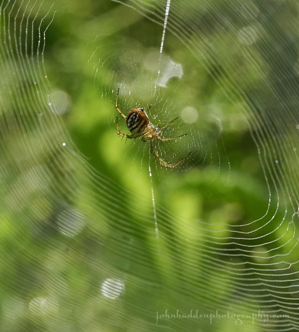
A small orb spider in her dew speckled web
Morning Observation:
This morning in Huntington at 9:05AM it’s currently 56 degrees under mostly clear skies. Winds are calm. Relative humidity is 93%, dewpoint 54, barometric pressure 30.34” and rising. Yesterday’s high was 70, and the overnight low was 40.
Forecast:
High pressure will continue rule the roost with dry weather and comfortable temperatures for most of this upcoming week. Highs mainly in the 60s to mid 70s with lows in the upper 30s to near 50 degrees depending upon location. The next chance for rain showers arrives Thursday with the passage of a cold front.
We’ll see partly cloudy skies today with highs around 72F and light and variable winds. Tonight should be clear with lows around 51F and light and variable winds.
Monday should be mainly sunny with highs around 76F and light and variable winds. Monday night shoulbe be partly cloudy with lows around 53F and light and variable winds.
Tuesday’s looking partly cloudy with highs around 76F and SE winds at 5 to 10 mph. Tuesday night should be partly cloudy with low around 52F and light and variable winds.
Almanac:
Last year on this date we had a high of 83 and a low of 57. We picked up 0.01″ of rain.
Burlington averages for this date are highs of 78 and lows of 57.
The record high was 96°F in 1948.
The record low was 40°F in 1987.
Sky Notes:
Sunrise: 6:10 AM
Sunset: 7:39 PM
Length of Visible Light: 14h 28m
Length of Day: 13h 28m
Tomorrow will be 2 minutes 53 seconds shorter
The Moon is a waxing crescent, 5.6 days old with 31% illumination.
Moonrise: 12:15PM
Moonset: 10:55PM
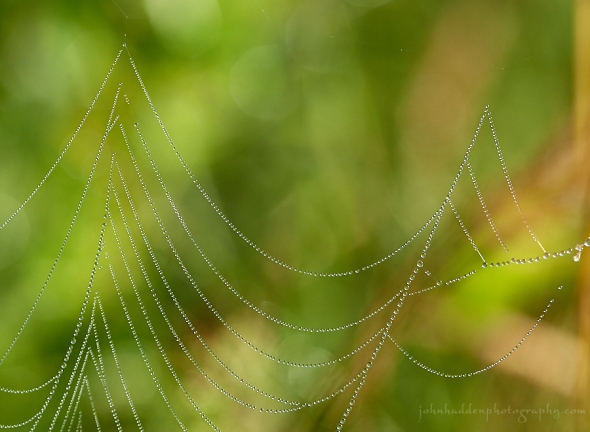
About Today’s Photo:
A small orb spider waits patiently for prey in her dew-speckled web in our front field.
Nikon D600, Sigma 105mm macro lens, ISO 1250, f/16, 1/400″ exposure.
Saturday, August 26, 2017


A sunflower blooming by one of our vegetable gardens
Morning Observation:
This morning in Huntington at 7:55AM it’s currently 51 degrees under clear skies. Winds are calm. Relative humidity is 99%, dewpoint 50, barometric pressure 30.27” and rising slowly. Yesterday’s high was 68, and the overnight low was 43.
Forecast:
Surface high pressure will continue to provide the region with mainly clear skies and comfortable temperatures into early next week. Highs generally will be in the 60s to lower 70s with cool overnight lows in the 40s to lower 50s. The next chance for scattered showers arrives on Thursday.
Any morning clouds will will give way to generally sunny skies for the afternoon today. Highs will be near 70F with NW winds at 5 to 10 mph. Tonight should be clear skies with lows around 49F and light and variable winds.
Sunday should be mostly sunny with highs around 72F and light and variable winds. Sunday night should be clear skies with lows around 51F and light and variable winds.
Monday’s looking mostly sunny with highs near 75F and light and variable winds. Monday night should be partly cloudy with lows around 53F and light and variable winds.
Almanac:
Last year on this date we had a high of 82 and a low of 58. We picked up 0.09″ of rain.
Burlington averages for this date are highs of 78 and lows of 57.
The record high was 97°F in 1947.
The record low was 39°F in 1942.
Sky Notes:
Sunrise: 6:09 AM
Sunset: 7:40 PM
Length of Visible Light: 14h 32m
Length of Day: 13h 31m
Tomorrow will be 2 minutes 53 seconds shorter.
The Moon is a waxing crescent, 4.6 days old with 22% illumination.
Moonrise: 11:15AM
Moonset: 10:24PM
About Today’s Photo:
Nothing says high summer like a sunflower!
Nikon D600, Sigma 105mm macro lens, ISO 800, f/8, 1/500″ exposure
Friday, August 25, 2017


Yellow coral and a moth on the forest floor
Morning Observation:
This morning in Huntington at 6:55AM it’s currently a cool 49 degrees under overcast skies. Winds are calm. Relative humidity is 99%, dewpoint 49, barometric pressure 30.09” and rising slowly. We picked up 0.14” of rain in the past 24hrs (yesterday morning). Yesterday’s high was 72, and the overnight low was 45.
Forecast:
A mid- to upper-level trough over the northeast this morning will continue to deliver cool and cloudy conditions today with a slight chance of an isolated shower this afternoon. Surface high pressure will build in from Canada clearing things out tonight and bringing clear and dry conditions through the middle of next week.
We’ll see cloudy skies early today followed by partial clearing. High will be around 68F with NNW winds at 5 to 10 mph. Tonight should be clear with lows around 49F and light and variable winds.
Saturday should be mostly sunny with highs around 71F and NW winds at 5 to 10 mph. Saturday night should be clear with low around 50F and light and variable winds.
Sunday’s looking mostly sunny with highs around 72F and light and variable winds. Sunday night should be partly cloudy early, giving way to generally clear skies overnight. Lows will be around 51F with light and variable winds.
Almanac:
Last year on this date we had a high of 81 and a low of 62.
Burlington averages for this date are highs of high of 78 and lows of 57. The record high was 97°F in 1947.
The record low was 39°F in 1942.
Sky Notes:
Sunrise: 6:08 AM
Sunset: 7:42 PM
Length of Visible Light: 14h 35m
Length of Day: 13h 34m
Tomorrow will be 2 minutes 52 seconds shorter
The Moon is a waxing crescent, 3.6 days old with 14% illumination.
Moonrise: 10:12AM
Moonset: 9:55 PM
About Today’s Photo:
This yellow coral fungus was just a few feet away from the violet coral that I posted a few days ago. It wasn’t until I had the image on my computer that I noticed the small (and very well camouflaged!) moth (possibly a gypsy moth?) hiding right next to it!
Panasonic GM5, Lumix 12-32mm lens @ 30mm, ISO 1600, f/5.6, 1/50″ exposure.
Thursday, August 24, 2017

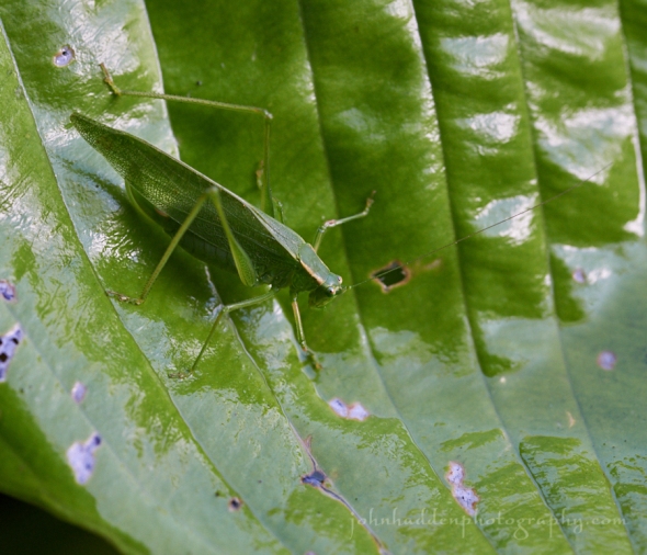
A katydid blends nicely with a hosta leaf by our front porch
Morning Observation:
This morning in Huntington at 7:10AM it’s currently 53 degrees under mostly cloudy skies. Winds are calm. Relative humidity is 98%, dewpoint 52, barometric pressure 29.88” and rising slowly. Yesterday’s high was 76, and the overnight low was 50.
Forecast:
An upper level trough of low pressure over eastern Canada and the Northeast will bring cooler conditions to the region today and Friday. There may be a few stray showers in the mountains this afternoon and then over northeastern Vermont on Friday. High pressure will build in for the weekend and a slow warming trend will take place as more sunshine develops across the area.
Today will be partly cloudy with a high of 69F and winds NW at 5 to 10 mph. Tonight should be partly cloudy with a low 49F and light and variable winds.
Friday should be partly cloudy with a high 67F and winds NW at 5 to 10 mph. Friday nigh should be mostly clear with a low of 48F and light and variable winds.
Saturday’s looking sunny with a high near 70F and winds NW at 5 to 10 mph. Saturday night should be mostly clear sky with a low of 49F and light and variable winds.
Almanac:
Last year on this date we had a high of 84 and a low of 53.
Burlington averages for this date are highs of
Sky Notes:
Sunrise: 6:07 AM
Sunset: 7:44 PM
Length of Visible Light: 14h 38m
Length of Day: 13h 37m
Tomorrow will be 2 minutes 51 seconds shorter
The Moon is a waxing crescent, 2.6 days old with 7.6% illumination.
Moonrise: 9:08 AM
Moonset: 9:26 PM
About Today’s Photo:
This katydid was hanging out on our front porch yesterday morning. I figured it would be happier on the hostas where it would be a bit better camouflaged…
Nikon D600, Sigma 105mm macro lens, ISO 800, f/8, 1/125″ exposure.
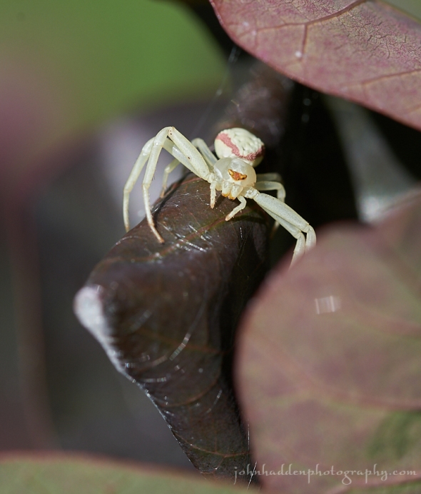
Wednesday, August 23, 2017


A crab spider catches a bumble bee by the pond
Morning Observation:
This morning in Huntington at 7:20AM it’s currently 59 degrees under mostly sunny skies. Winds are calm. Relative humidity is 97%, dewpoint 58, barometric pressure 29.69” and rising rapidly. We picked up 0.62” of rain in the past 24hrs. Happily no tornados here… Yesterday’s high was 85, and the overnight low was 59.
Forecast:
With the passage of the cold front overnight, noticeably cooler and drier air will be moving into the region. A couple of upper level troughs will cross the region today and Thursday making for a possible spotty shower here or there, but otherwise, high pressure will be building into the region and will dominate our weather through the upcoming weekend. Temperatures will trend a few degrees below normal through the weekend, but sunny and dry conditions should be the rule.
We’ll see mostly sunny skies today. Highs will be in the mid 70s with west winds 10 to 15 mph. Tonight should be partly cloudy with lows in the lower 50s and west winds 10 to 15 mph.
Thursday should be partly sunny with highs around 70 and light and variable winds, becoming northwesterly around 10 mph in the afternoon. Thursday night should be partly cloudy with lows around 50 and light and variable winds.
Friday’s looking partly sunny with highs around 70 and northwest winds around 10 mph. Friday night should be mostly clear with lows in the upper 40s.
Almanac:
Last year on this date we had a high of 77 and a low of 45.
Burlington averages for this date are highs of 78 and lows of 58.
The record high was 93°F in 1947.
The record low was 43°F in 1988.
Sky Notes:
Sunrise: 6:04 AM EDT
Sunset: 7:43 PM EDT
Length of Visible Light: 14h 40m
Length of Day: 13h 38m
Tomorrow will be 2m50s shorter.
The Moon is a waxing crescent, 1.6 days old with 3% illumination.
Moonrise: 8:01 AM EDT
Moonset: 8:57 PM EDT
About Today’s Photo:
Robin noticed this bit of terrestrial action while I was out in the observatory shooting eclipse photos the other day. A crab spider, lurking on a evening primrose by the pond, managed to snag a bumble bee. As is the way with spiders, after stunning the bee with venom, it injects a digestive fluid and then sucks the desolved innards. Yum!
Panasonic GX8, Lumix 14-140mm lens @ 140mm, ISO 800, f/13, 1/500″ exposure.
Tuesday, August 22, 2017

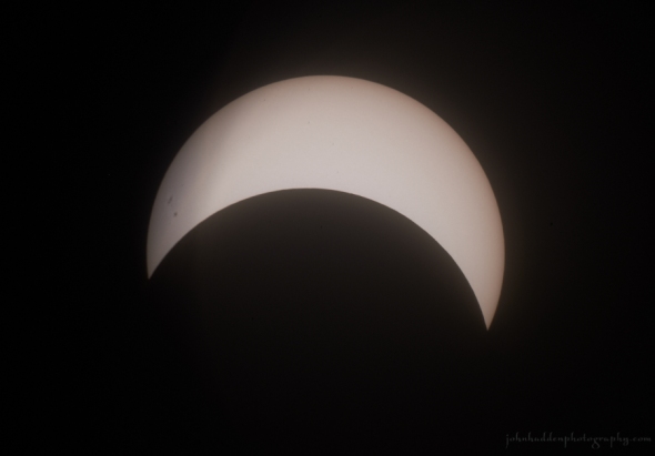
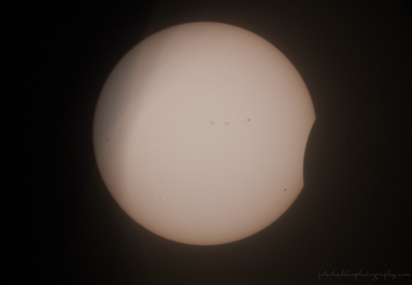
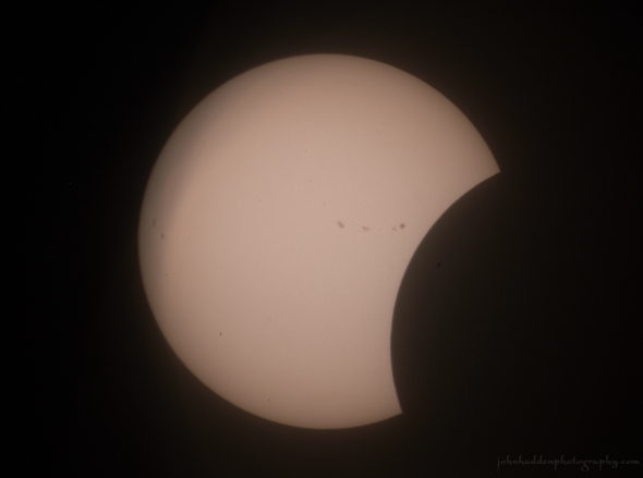
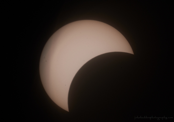
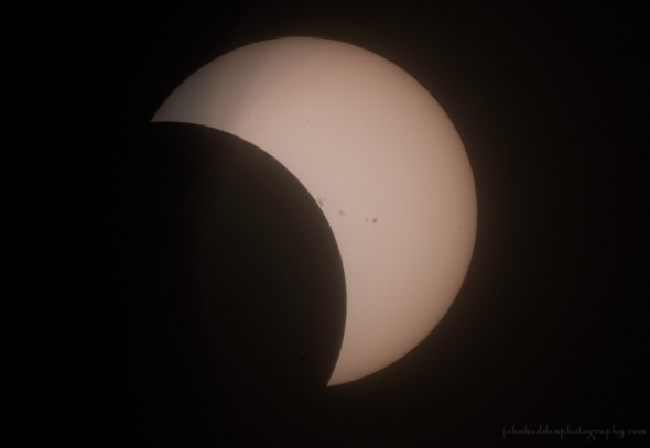
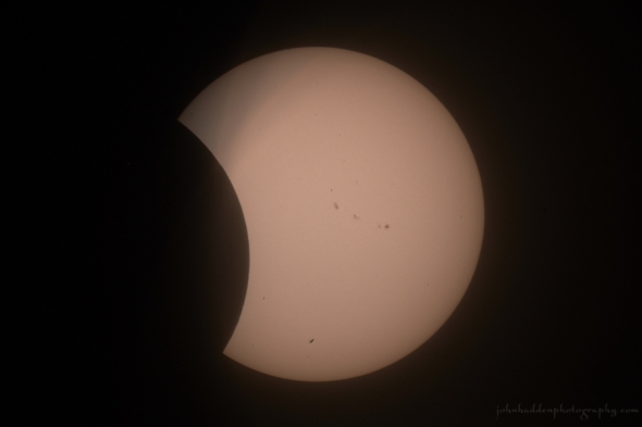
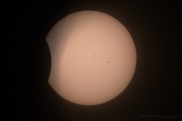
Our solar eclipse at maximum coverage yesterday at 2:41PM
Morning Observation:
This morning in Huntington at 7:10AM it’s currently 61 degrees under hazy clear skies. Winds are calm. Relative humidity is 99%, dewpoint 61, barometric pressure 29.93” and falling slowly. Yesterday’s high was 84, and the overnight low was 60.
Forecast:
Low pressure over the northern Great Lakes will deepen as it tracks northeastward towards Québec today. A strong upper level trough will move through the region kicking off thunderstorms out ahead of an approaching cold front. Some storms may have damaging winds and very heavy rain. The cold front will move across the region overnight an storms come to an end. The remainder of the week is looking to be cooler and drier with below normal temperatures into the weekend.
We’ll see partly sunny skies this morning with showers and thunderstorms likely this afternoon. Some thunderstorms may be severe with damaging winds and heavy rainfall. Highs will be in the mid 80s with south winds 10 to 15 mph. Chance of rain is 70%. Tonight showers and thunderstorms are likely until midnight, then showers likely after midnight. Some thunderstorms may be severe with damaging winds, and heavy rainfall. Lows will be around 60 with southwest winds 10 to 15 mph. Chance of rain is 90%.
Wednesday should be partly sunny with a 20% slight chance of lingering showers in the morning. It’ll be less humid with highs in the mid 70s and west winds 10 to 15 mph. Wednesday night should be partly cloudy with lows in the lower 50s and west winds 10 to 15 mph.
Thursday’s looking partly sunny and cool with highs only in the upper 60s and west winds around 10 mph. Thursday night should be partly cloudy with lows around 50.
Almanac:
Last year on this date we had a high of 66 and a low of 48. We picked up 0.35″ of rain.
Burlington averages for this date are highs of 78 and lows of 58.
The record high was 90°F in 1916.
The record low was 39°F in 1982.
Sky Notes:
Sunrise: 6:03 AM EDT
Sunset: 7:45 PM EDT
Length of Visible Light: 14h 43m
Length of Day: 13h 41m
Tomorrow will be 2m51s shorter.
The Moon is a waxing crescent, .5 days old with 0.3% illumination.
Moonrise: 6:52 AM EDT
Moonset: 8:25 PM EDT
About Today’s Photo:
The solar eclipse reached maximum coverage here in Huntington at 2:41PM yesterday. I took a series of shots at 5 minute intervals using my 9″ telescope, mylar filter, and camera. If you look closely at the left side of the image, you’ll see a group of sunspots!
Nikon D600, Meade LX90 telescope @ 2000mm, ISO 100, f/8, 1/1250″ exposure.

Monday, August 21, 2017: Eclipse Day!

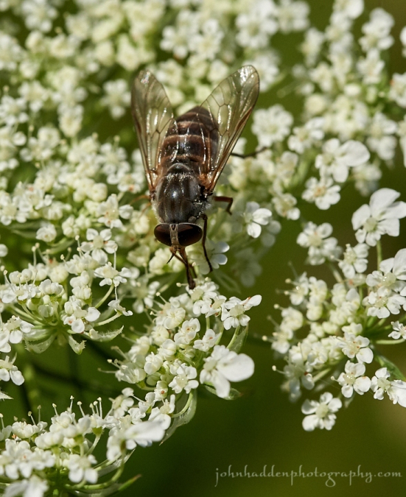
A fly enjoys the nectar of Queen Anne’s Lace
Morning Observation:
This morning in Huntington at 7:40AM it’s currently 59 degrees under partly cloudy skies. Winds are calm. Relative humidity is 99%, dewpoint 59, barometric pressure 30.12” and steady. Yesterday’s high was 80, and the overnight low was 55.
Forecast:
It looks like we’ve got a great day on tap to catch the eclipse! High pressure over the region this morning will deliver mostly clear skies today with temperatures on the warm side—upper 80s—courtesy of a southerly airflow out ahead of the next weather maker. Low pressure moving out of the upper Great Lakes will bring another round of showers and thunderstorms Tuesday, with showers lingering into Wednesday. The remainder of the week is looking to be mainly dry, with plentiful sunshine and seasonably cool temperatures into the weekend.
We’ll see partly sunny skies this morning, then clearing. Highs will be in the mid 80s with southwest winds around 10 mph. Tonight should be mostly clear with lows in the mid 60s and southwest winds around 10 mph.
Tuesday should start out partly sunny with showers and thunderstorms likely in the afternoon. Some thunderstorms may produce gusty winds, and heavy rainfall in the afternoon. Highs will be in the mid 80s with south winds 10 to 15 mph. Chance of rain is 70%. Tuesday night rain is likely with scatterd thunderstorms. Some thunderstorms may produce gusty winds, and heavy rainfall. Lows will be in the lower 60s with southwest winds 10 to 15 mph gusting up to 25 mph. Chance of rain is 90%.
Wednesday should be partly sunny with a 50% chance of lingering showers. It’ll be cooler and less humid with highs in the mid 70s and west winds around 10 mph. Wednesday night should be partly cloudy with lows in the lower 50s.
Almanac:
Last year on this date we had a high of 81 and a low of 61.
Burlington averages for this date are highs of 79 and lows of 58.
The record high was 93°F in 1945.
The record low was 43°F in 1934.
Sky Notes:
Sunrise: 6:02 AM EDT
Sunset: 7:46 PM EDT
Length of Visible Light: 14h 46m
Length of Day: 13h 44m
Tomorrow will be 2m50s shorter.
The Moon is new 29 days old with 0% illumination.
Moonrise: 5:41 AM EDT
Moonset: 7:51 PM EDT
The Solar Eclipse!
The eclipse here in Huntington will begin at 1:23PM this afternoon and will reach 60.56% of totality at 2:41PM. It’ll wrap up at 3:53PM.
As it’s been discussed seemingly non-stop for months now, you probably know how the physics work (unless you’re a flat-earther…), but just in case: The solar eclipse occurs when the moon passes in front of the sun. By a wonderful quirk of nature, the visible disc of the moon and that of the sun are pretty much exactly the same diameter, so, when they align—as they will for a broad swath of American territory today—the moon blocks the sun and casts its shadow across the surface of the earth. Totality is quite stunning, but those of us not in the total track should have a wonderful experience as well. Be sure to take a look at the shadows cast by the sun at maximum—leaves and other objects will cast tiny crescents here.
And please: DO NOT LOOK DIRECTLY AT THE SUN AT ANY TIME DURING OUR PARTIAL ECLISPE WITHOUT PROPER EYE PROTECTION! This can’t be emphasized enough. The only safe way to observe the eclipse is with proper eclipse-watching eyewear or with a pinhole projector. Don’t use sunglasses okay!
Enjoy the show!
Sunday, August 20, 2017

Tiger lilies by Fargo Brook
Morning Observation:
This morning in Huntington at 7:20AM it’s currently a muggy 62 degrees under mostly cloudy skies. Winds are calm. Relative humidity is 98%, dewpoint 62, barometric pressure 29.92” and rising rapidly. We picked up a 0.01” trace of rain in the past 24hrs. Yesterday’s high was 81, and the overnight low was 60.
Forecast:
High pressure is beginning to build into the region and will dominate our weather through Monday with highs in the mid 70s to lower 80s today along with less humid air. Temperatures will warm into the mid 80s to near 90 on Tuesday, but an approaching trough of low pressure will bring showers and thunderstorms Tuesday afternoon and night.
We’ll see partly sunny skies today with highs in the upper 70s and west winds around 10 mph. Tonight should be mostly clear with lows around 60 and west winds around 10 mph until midnight, becoming light and variable.
Monday should be sunny with highs in the mid 80s and southwest winds around 10 mph. Conditions should be good for eclipse viewing! Monday night should be partly cloudy with lows in the mid 60s and south winds around 10 mph.
Tuesday’s looking partly sunny with a 50% chance of showers. Highs will be in the mid 80s to 90 with south winds 10 to 15 mph gusting up to 25 mph. Tuesday night showers are likely. Lows will be in the mid 60s. Chance of rain is 80%.
Almanac:
Last year on this date we had a high of 84 and a low of 51.
Burlington averages for this date are highs of 79 and lows of 58.
The record high was 94°F in 1916.
The record low was 42°F in 1953.
Sky Notes:
Sunrise: 6:01 AM EDT
Sunset: 7:48 PM EDT
Length of Visible Light: 14h 49m
Length of Day: 13h 47m
Tomorrow will be 2m49s shorter.
The Moon is a waning crescent, 28 days old with 3% illumination.
Moonrise: 4:31 AM EDT
Moonset: 7:12 PM EDT
About Today’s Photo:
The tiger lilies that Robin planted in a bed by Fargo Brook are on their last legs, especially after the rain and hail we had the other day. I took this shot of these spectacular (and fragrant!) blossoms the day of the hail. Interestingly, I’ve noticed that our native pollinators seem to ignore these gaudy flowers.
Nikon D600, Sigma 105mm macro lens, ISO 800, f/16, 1/60″ exposure.
Saturday, August 19, 2017

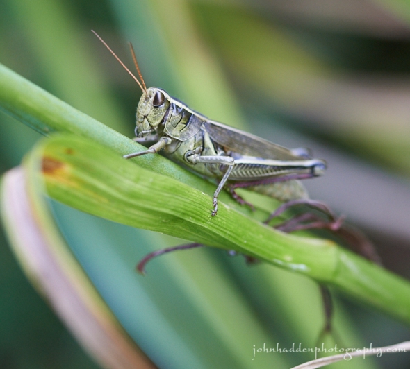
A grasshopper poses briefly for the camera
Morning Observation:
This morning in Huntington at 7:25AM it’s currently 66 degrees under partly cloudy skies. Winds are calm. Relative humidity is 99%, dewpoint 65, barometric pressure 29.76” and rising slowly. We picked up 0.89” of rain in the past 24hrs. Yesterday’s high was 81, and the overnight low was 63.
Forecast:
An upper level trough of low pressure will move east out of the upper Midwest today reaching northern New England by tonight. Clouds and a few showers are expected across the region today and into this evening with highs in the mid 70s to lower 80s. Drier air moves in on Sunday with more sunshine expected and highs once again in the mid 70s to lower 80s. We are still looking at mostly sunny skies for Monday for the solar eclipse, with highs in the lower to mid 80s. Another trough of low pressure approaches the region on Tuesday bringing renewed chances for showers and thunderstorms.
We’ll see partly sunny skies today with isolated showers this afternoon. Highs will be around 80 with southwest winds around 10 mph. Chance of rain is 20%. Tonight should be partly cloudy until midnight, then becoming mostly cloudy with isolated showers. Lows will be in the lower 60s with west winds around 10 mph. Chance of rain is 20%.
Sunday should be partly sunny with highs in the upper 70s and west winds around 10 mph. Sunday night should be mostly clear with lows in the lower 60s and southwest winds around 10 mph.
Monday’s looking mostly sunny with highs in the mid 80s and southwest winds around 10 mph. Monday night should be partly cloudy with lows in the mid 60s.
Almanac:
Last year on this date we had a high of 80 and a low of 54.
Burlington averages for this date are highs of 79 and lows of 58.
The record high was 93°F in 1899.
The record low was 40°F in 1963.
Sky Notes:
Sunrise: 6:00 AM EDT
Sunset: 7:50 PM EDT
Length of Visible Light: 14h 52m
Length of Day: 13h 50m
Tomorrow will be 2m48s shorter.
The Moon is a waning crescent, 26.8 days old with 8% illumination.
Moonrise: 3:23 AM EDT
Moonset: 6:27 PM EDT
About Today’s Photo:
I had to chase this agile grasshopper around our back garden for a couple of minutes before it finally settled long enough for me to get a shot. I’m always impressed by the armor-like exoskeleton of these tough little critters.
Nikon D600, Sigma 105mm macro lens, ISO 800, f/3.5, 1/160″ exposure.
Friday, August 18, 2017

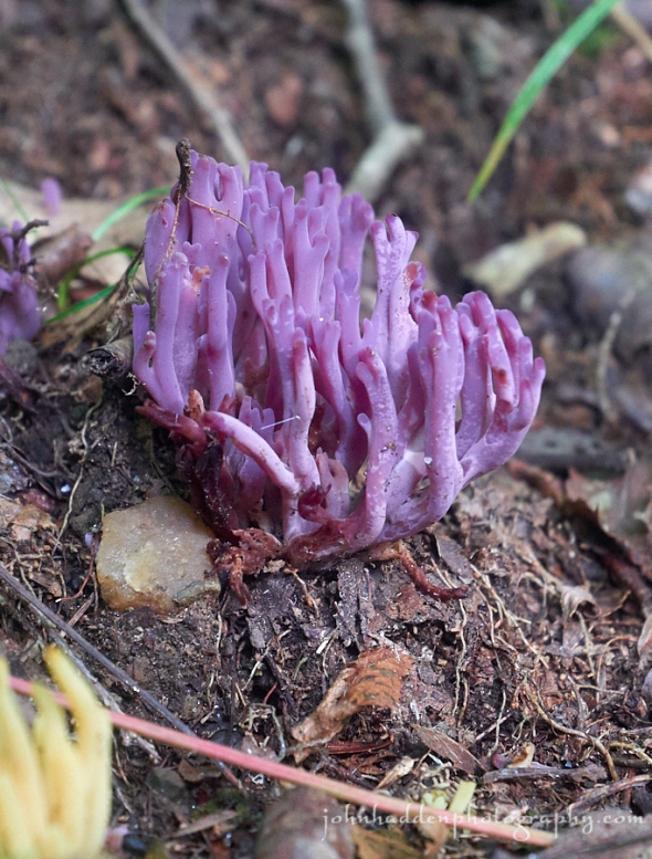
Violet coral in the woods near Taft Road
Morning Observation:
This morning in Huntington at 7:30AM it’s currently 63 degrees and raining under overcast skies. Winds are calm. Relative humidity is 96%, dewpoint 62, barometric pressure 29.82” and falling slowly. We picked up 0.24” of rain overnight. Yesterday’s high was 78, and the overnight low was 57.
Forecast:
Low pressure over the Great Lakes this morning has rotated a warm front into region bringing showers which should persist to around midday. After a lull in the rain, the low will rotate a cold front across the region during the afternoon hours bringing additional showers and storms, some with potentially heavy downpours, to the northern ‘Dacks and eastward across the Champlain Valley and remainder of Vermont. Any showers and storms should come to an end later tonight. On Saturday expect a chance for showers in the afternoon, but
the areal coverage will be scattered in nature. Highs on Saturday will be in the mid 70s to lower 80s. Drier air will begin to move into the region on Sunday with highs once again in the mid 70s to lower 80s.
We’ll see cloudy skies with occasional showers this morning, then partly sunny skies with scattered showers this afternoon. Highs will be in the mid 70s with southeast winds 10 to 15 mph. Chance of rain is 90%. Tonight should be partly cloudy with scattered showers and isolated thunderstorms until midnight. Some thunderstorms may produce heavy rainfall until midnight. Lows will be in the lower 60s with south winds around 10 mph. Chance of rain is 50%.
Saturday should be partly sunny with a slight chance of showers in the morning, then a 30% chance of showers in the afternoon. Highs will be in the upper 70s with southwest winds around 10 mph. Saturday night shoild be partly cloudy with a 50% chance of showers. Lows will be in the upper 50s with west winds around 10 mph.
Sunday’s looking partly sunny with a 40% chance of lingering showers. Highs will be in the upper 70s with west winds around 10 mph. Sunday night should be mostly clear with lows around 60.
Almanac:
Last year on this date we had a high of 81 and a low of 56. We picked up 1.58″ of rain.
Burlington averages for this date are highs of 79 and lows of 59.
The record high was 93°F in 2002 (we had a high of 89).
The record low was 40°F in 1918.
Sky Notes:
Sunrise: 5:58 AM EDT
Sunset: 7:51 PM EDT
Length of Visible Light: 14h 55m
Length of Day: 13h 52m
Tomorrow will be 2m47s shorter.
The Moon is a waning crescent, 25.7 days old with 16% illumination.
Moonrise: 2:21 AM EDT
Moonset: 5:35 PM EDT
About Today’s Photo:
I came across this popping patch of violet coral while out running the other morning. A member of the worm corals (Clavaria), violet coral is one of the more eye-catching varieties. You’ll also see white, yellow, and smokey versions.
Panasonic GM5, Lumix 12-32mm lens @ 32mm, ISO 1600, f/5.6, 1/50″ exposure.
Thursday, August 17, 2017


A carpenter bee works the hydrangea on our back patio
Morning Observation:
This morning in Huntington at 7:30AM it’s currently a cool 53 degrees under cloudy skies. Winds are calm. Relative humidity is 99%, dewpoint 52, barometric pressure 30.06”. Yesterday’s high was 72, and the overnight low was 46.
Forecast:
High pressure over the region today will bring dry weather with temperatures in the 70s to around 80. Low pressure moving out of the Great Lakes will lift a warm front into the region later tonight from the southwest bringing showers and a few thunderstorms. Showers and a few thunderstorms will impact the region Friday with the potential for some stronger storms over northern New York late in the day on Friday. Showers and storms should taper off Friday night, with some lingering showers persisting into Saturday.
We’ll see mostly sunny skies today with highs in the mid 70s and light and variable winds, becoming northwesterly around 10 mph this afternoon. Tonight should be partly cloudy with a 30% chance of showers after midnight. Lows will be in the upper 50s with light and variable winds, becoming southeasterly around 10 mph after midnight.
Friday showers are likely with a slight chance of thunderstorms. Highs will be in the lower 70s with southeast winds 10 to 15 mph. Chance of rain is 70%. Friday night showers are likely. Lows will be in the lower 60s with south winds 10 to 15 mph. Chance of rain is 60%.
Saturday’s looking partly sunny with highs around 80 and southwest winds around 10 mph. Saturday night should be partly cloudyw with lows around 60.
Almanac:
Last year on this date we had a high of 76 and a low of 57.
Burlington averages for this date are highs of 79 and lows of 59.
The record high was 95°F in 1987.
The record low was 42°F in 1961.
Sky Notes:
Sunrise: 5:57 AM EDT
Sunset: 7:53 PM EDT
Length of Visible Light: 14h 58m
Length of Day: 13h 55m
Tomorrow will be 2m46s shorter.
The Moon is a waning crescent, 24.6 days old with 25% illumination.
Moonrise: 1:25 AM EDT
Moonset: 4:36 PM EDT
About Today’s Photo:
The hydrangea on our back patio is in full bloom now, and a large cast of pollinators are busy lapping up the nector. The hydrangea’s larger white flowers are sterile and act as nice big lures to draw pollinators into the fertile flowerettes. This eastern carpenter bee (ID?) had no problem zeroing in on the good stuff. This appears to be a pretty good year for honey bees at our house as I’d wager 80% of the pollinators at this busy feeding place were honey bees.
Nikon D600, Sigma 105mm macro lens, ISO 800, f/13, 1/3200″ exposure.
Wednesday, August 16, 2017

A crab spider guards her egg case
Morning Observation:
This morning in Huntington at 7:40AM it’s currently 61 degrees under mostly cloudy skies. Winds are calm. Relative humidity is 98%, dewpoint 60, barometric pressure 29.96” and rising rapidly. We picked up 1.56” of rain in a 40 minute downpour starting at around 7:40PM last night. There was some pea-sized hail mixed in for good measure as well. Quite the storm! Yesterday’s high was 81, and the overnight low was 58.
Forecast:
High pressure building in from Canada will deliver dry weather across the region today and continuing into Thursday. It’ll be on the cool side today with highs only in the upper 60s to mid 70s, but temperatures should rebound to seasonal norms both Thursday and Friday. Low pressure moving out of the Great Lakes on Friday will bring showers and a few thunderstorms back into the region especially Friday afternoon and night.
We’ll see mostly cloudy skies this morning, then clearing. Highs will be in the lower 70s with northwest winds around 10 mph. Tonight should be clear with lows around 50 and northwest winds around 10 mph until midnight, becoming light and variable.
Thursday should be mostly sunny with highs in the mid 70s and light and variable winds. Thursday night should be partly cloudy with lows in the upper 50s and light and variable winds.
Friday’s looking cloudy with a 50% chance of showers. Highs will be in the mid 70s with southeast winds around 10 mph. Friday night showers are likely. Lows will be in the lower 60s. Chance of rain is 70%.
Almanac:
Last year on this date we had a high of 73 and a low of 56. We picked up 1.25″ of rain.
Burlington averages for this date are highs of 79 and lows of 59.
The record high was 96°F in 1944.
The record low was 43°F in 1923.
Sky Notes:
Sunrise: 5:56 AM EDT
Sunset: 7:54 PM EDT
Length of Visible Light: 15h 01m
Length of Day: 13h 58m
Tomorrow will be 2m44s shorter.
The Moon is a waning crescent, 23.5 days old with 36% illumination.
Moonrise: 12:36 AM EDT
Moonset: 3:30 PM EDT
About Today’s Photo:
I noticed this little crab spider the other day in the smoke bush right by the corner of our garage. She’d laid her eggs on a leaf and carefully folded the leaf and sewn it up with silk to form a protective case. She’ll stay their and guard the eggs until they hatch. With any luck, I’ll be able to observe that moment as well!
Nikon D600, Sigma 105mm macro lens, ISO 200, f/8, 1/320″ exposure.
Tuesday, August 15, 2017


Pagoda dogwood berries along Taft Road
Morning Observation:
This morning in Huntington at 7:40AM it’s currently 64 degrees under partly cloudy skies. Winds are calm. Relative humidity is 99%, dewpoint 64, barometric pressure 29.87” and steady. Yesterday’s high was 80, and the overnight low was 55.
Forecast:
An upper level trough of low pressure over central Québec will rotate a cold front through the region later this afternoon kicking off showers and thunderstorms. Some storms could be strong and produce gusty winds, small hail, frequent lightning, and brief heavy downpours. The system will move east tonight
allowing cooler and drier weather to move in. Dry weather is expected on Thursday as well with slightly warmer temperatures than Wednesday. The next chance for more widespreadnshowers will come late Thursday night and especially on Friday as low pressure moves out of the Great Lakes.
We’ll see partly sunny skies today with showers and scattered thunderstorms this afternoon. Some thunderstorms may produce gusty winds, and small hail this afternoon. Highs will be in the upper 70s with southwest winds around 10 mph. Chance of rain is 70%. Tonight should be mostly cloudy until midnight, then becoming partly cloudy with scattered showers and isolated thunderstorms until midnight. Lows will be in the upper 50s with light and variable winds. Chance of rain is 50%.
Wednesday should be partly sunny and seasonably cool with highs in the lower 70s and northwest winds around 10 mph. Wednesday night should be clear with lows in the lower 50s and northwest winds around 10 mph.
Thursday’s looking partly sunny with highs in the mid 70s and light and variable winds. Thursday night should be partly cloudy with a 30% chance of showers. Lows will be in the mid 50s.
Almanac:
Last year on this date we had a high of 79 and a low of 58.
Burlington averages for this date are highs of 79 and lows of 59.
The record high was 97°F in 1944.
The record low was 45°F in 1907.
Sky Notes:
Sunrise: 5:55 AM EDT
Sunset: 7:56 PM EDT
Length of Visible Light: 15h 04m
Length of Day: 14h 01m
Tomorrow will be 2m44s shorter.
The Moon is a waning crescent, 22.4 days old with 47% illumination.
No Moon Rise
Moonset: 2:22 PM EDT
About Today’s Photo:
i
Monday, August 14, 2017

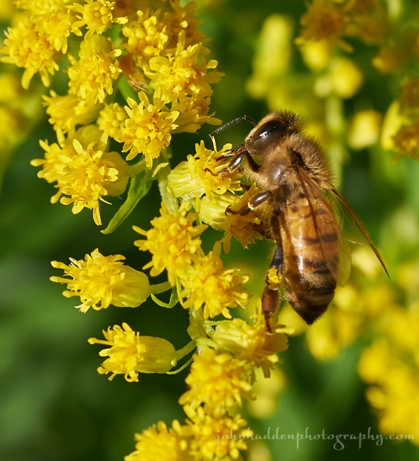
A honey bee works goldenrod blooms in our front field
Morning Observation:
This morning in Huntington at 8:00AM it’s currently 60 degrees under partly cloudy skies. Winds are calm. Relative humidity is 99%, dewpoint 59, barometric pressure 30.05” and rising slowly. Yesterday’s high was 78, and the overnight low was 49.
Forecast:
Weak high pressure over the region today will deliver dry and partly sunny conditions today with no precipitation expected. A trough of low pressure will drop down from Canada bringing the chance for precipitation later tonight into Tuesday. Drier conditions will return Wednesday with cooler temperatures in the 70s.
We’ll see partly sunny skies today with highs around 80 and light and variable winds. Tonight should be partly cloudy with lows in the upper 50s and south winds around 10 mph.
Tuesday should start out partly sunny in the morning with a slight chance of showers, then become cloudy with a 30% chance of showers and a slight chance of thunderstorms in the afternoon. Highs will be in the upper 70s with southwest winds around 10 mph. Tuesday night should be partly cloudy with a 30% chance of showers. Lows will be in the upper 50s with light and variable winds.
Wednesday’s looking partly sunny and seasonably cool with highs in the lower 70s and northwest winds 10 to 15 mph. Wednesday night should be mostly clear with lows around 50.
Almanac:
Last year on this date we had a high of 86 and a low of 68. We picked up 1.12″ of rain.
Burlington averages for this date are highs of 80 and lows of 59.
The record high was 96°F in 1944.
The record low was 47°F in 1923.
Sky Notes:
Sunrise: 5:54 AM EDT
Sunset: 7:58 PM EDT
Length of Visible Light: 15h 06m
Length of Day: 14h 03m
Tomorrow will be 2m43s shorter.
The Moon is waning gibbous, 21.4 days old with 58% illumination.
Moonrise: 11:54 PM EDT
Moonset: 1:12 PM EDT
About Today’s Photo:
Goldenrod is in bloom in our front field and the honey bees and other pollinators are hard at it collecting nectar and pollen.
Nikon D600, Sigma 105mm macro lens, ISO 800, f/13, 1/500″ exposure.
Sunday, August 13, 2017

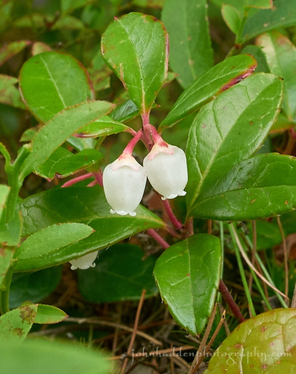
Wintergreen flowering on Owl’s Head in Groton State Park
Morning Observation:
This morning in Huntington at 8:15AM it’s currently a muggy 63 degrees under overcast skies. We just had a brief shower pass through. Relative humidity is 98%, dewpoint 63, barometric pressure 29.85” and rising. We picked up 0.05” of rain in the past 24hrs. Yesterday’s high was 82, and the overnight low was 59.
Forecast:
An upper trough is moving quickly across southern Québec this morning and will bring isolated to scattered showers the far northern tiers of New York and Vermont through mid morning. High pressure will build in later this afternoon bringing drier air and seasonably cool temperatures. At this point it’s looking like we’ll see mostly dry conditions for begining of the week with some showers returning Thursday.
We’ll see partly sunny skies today with isolated showers this morning. Highs will be in the mid 70s with northwest winds 10 to 15 mph. Chance of rain is 20%. Tonight should be clear with lows in the mid 50s and west winds around 10 mph until midnight, becoming light and variable.
Monday should be mostly sunny with highs in the upper 70s and light and variable winds. Monday night should be partly cloudy with lows in the upper 50s and light and variable winds.
Tuesday’s looking partly sunny with a 30% chance of showers and thunderstorms as a weak upper low tracks to our north. Highs will be around 80 with west winds around 10 mph. Tuesday night should be partly cloudy with a 30% chance of showers and thunderstorms. Lows will be in the upper 50s.
Almanac:
Last year on this date we had a high of 83 and a low of 66. We picked up 0.43″ of rain.
Burlington averages for this date are highs of 80 and lows of 59.
The record high was 97°F in 1947.
The record low was 43°F in 1930.
Sky Notes:
Sunrise: 5:53 AM EDT
Sunset: 7:59 PM EDT
Length of Visible Light: 15h 09m
Length of Day: 14h 06m
Tomorrow will be 2m41s shorter.
The Moon is waning gibbous, 20 days old with 69% illumination.
Moonrise: 11:18 PM EDT
Moonset: 12:03 PM EDT
About Today’s Photo:
Wintergreen is one of the plants I routinely seek out when I’m hiking in the woods. I usually pop a few of the thick leaves in my mouth and enjoy the minty flavor as I walk. The plant was in bloom as we climbed to the top of Owl’s Head in Groton State Park the other day. As I’m sure you’re aware, winterberry has myriad uses, from flavorings to printing of fine art (who knew!), and contains salicylic acid, the active ingredient found in aspirin.
Panasonic GM5, Lumix 12-32mm lens @ 32mm, ISO 800, f/13, 1/100″ exposure.
Thursday, August 10, 2017

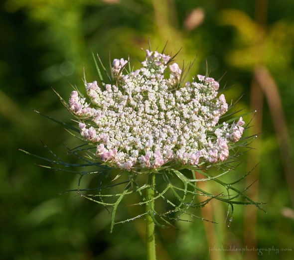
Just-blooming Queen Anne’s lace with a bit of blush
Morning Observation:
This morning in Huntington at 7:20AM it’s currently 59 degrees under partly cloudy skies. Winds are calm. Relative humidity is 98%, dewpoint 59, barometric pressure 30.21” and rising slowly. Yesterday’s high was 78, and the overnight low was 54.
Forecast:
Weak high pressure across the region today and Friday will do its best hold off showers, but increasing humidity and daytime temperatures will help to spur isolated thunderstorms this afternoon, and scattered afternoon showers and thunderstorms on Friday. Skies should be partly sunny with high temperatures reaching the lower 80s in most valley locations today and Friday. A more vigorous upper level trough and associated surface low moving out of the Great Lakes will bring more widespread cloud cover and greater coverage of showers and embedded thunderstorms and Saturday with lingering showers Sunday
We’ll see partly sunny skies today with a 20% chance of showers and thunderstorms. Highs will be in the upper 70s with southwest winds around 10 mph. Tonight should bring a slight chance of thunderstorms until midnight. It’ll be partly cloudy with a 20% chance of showers. Lows will be in the lower 60s with light and variable winds.
Friday should be partly sunny with a 40% of showers and a slight chance of thunderstorms in the afternoon. Highs will be around 80 with light and variable winds, becoming southwesterly around 10 mph in the afternoon. Friday night should be mostly cloudy with a 40% chance of showers. Lows will be around 60 with south winds around 10 mph.
Saturday should be mostly cloudy with a 50% chance of showers. Highs will be in the mid 70s with south winds 10 to 15 mph. Saturday night should be mostly cloudy with a 50% chance of showers. Lows will be in the upper 50s.
Almanac:
Last year on this date we had a high of 85 and a low of 57.
Burlington averages for this date are highs of 80 and lows of 59.
The record high was 97°F in 1949.
The record low was 47°F in 1922.
Sky Notes:
Sunrise: 5:49 AM EDT
Sunset: 8:04 PM EDT
Length of Visible Light: 15h 18m
Length of Day: 14h 14m
Tomorrow will be 2m37s shorter.
The Moon is waning gibbous, 17.2 days old with 93% illumination.
Moonrise: 9:44 PM EDT
Moonset: 8:41 AM EDT
About Today’s Photo:
I don’t think I’ve noticed Queen Anne’s lace with a bit of blush before, but I’ve seen several instances of it this season in our front field. This stately composite flower attracts a wide range of pollinators.
Nikon D600, Sigma 105mm macro lens, ISO 640, f/18, 1/400″ exposure.
Wednesday, August 9, 2017

Dew drops cling to a spider’s web in our front field.
Morning Observation:
This morning in Huntington at 7:25AM it’s currently 56 degrees under mostly clear skies. Winds are calm. Relative humidity is 98%, dewpoint 55, barometric pressure 30.09” and rising slowly. Yesterday’s high was 76, and the overnight low was 50.
Forecast:
A weak cold front approaching from southeastern Ontario and Québec will spark a few showers or a thunderstorm this afternoon. Otherwise, skies will be partly to mostly sunny for most of the day, with highs generally in the upper 70s to
lower 80s. We’ll see a gradual warming trend into Thursday and Friday, with highs reaching the low to mid 80s in most locations. A stray shower or thunderstorm will be possible both Thursday and Friday afternoon. A slow moving low pressure system approaching from the Great Lakes on Saturday will bring a more widespread threat of showers and thunderstorms going into the weekend.
We’ll see partly sunny skies today with a 20% chance of showers and thunderstorms this afternoon. Highs will be in the mid 70s with southwest winds 10 to 15 mph, becoming westerly this afternoon. Tonight should be partly cloudy with a 20% chance of showers until midnight. Lows will be in the upper 50s with west winds around 10 mph until midnight, becoming light and variable.
Thursday should be partly sunny with a 20% chance of showers and thunderstorms in the afternoon. Highs will be in the lower 80s with light and variable winds. Thursday night should be partly cloudy with lows around 60 and light and variable winds.
Friday’s looking partly sunny with highs around 80 and south winds around 10 mph. Friday night should be mostly cloudy with a 50% chance of showers as the aforementioned low starts to move in. Lows will be in the upper 50s.
Almanac:
Last year on this date we had a high of 85 and a low of 49.
Burlington averages for this date are highs of 80 and lows of 60.
The record high was 99°F in 2001 (we had a high of 91).
The record low was 44°F in 1922.
Sky Notes:
Sunrise: 5:48 AM EDT
Sunset: 8:05 PM EDT
Length of Visible Light: 15h 21m
Length of Day: 14h 17m
Tomorrow will be 2m36s shorter.
The Moon is waning gibbous, 16.2 days old with 97% illumination.
Moonrise: 9:14 PM EDT
Moonset: 7:36 AM EDT
About Today’s Photo:
Spider web strands hold beads of dew like stings of pearls. The drops cling to the sticky material that spiders place at intervals along their webs to capture prey.
Nikon D600, Sigma 105mm macro lens, ISO 640, f/8, 1/1000″ exposure
Tuesday, August 8, 2017

A jewelweed blossom bedecked with morning dew
Morning Observation:
This morning in Huntington at 7:50AM it’s currently 58 degrees under partly cloudy skies. Winds are calm. Relative humidity is 98%, dewpoint 58, barometric pressure 29.94” and rising slowly. We picked up 0.52” of rain in the past 24hrs. Yesterday’s high was 76, and the overnight low was 55.
Forecast:
The low pressure system that delivered yesterday’s rain is moving to our east this morning. Any remaining showers will shut down, and surface high pressure will begin to build in. A trailing mid-level trough may spur a few higher elevation showers this afternoon. Otherwise, conditions should be dry and warming. An active weather pattern returns for the latter part of the week into the weekend with daily chances of showers and embedded thunderstorms.
We’ll see mostly cloudy skies this morning, then becoming partly sunny with a 20% chance of showers. Highs will be in the lower 70s with light and variable winds, becoming northwesterly around 10 mph this afternoon. Tonight should be mostly clear until midnight, then become partly cloudy. Lows will be in the mid 50s with west winds around 10 mph, becoming southerly after midnight.
Wednesday should be partly sunny with a 30% chance of showers and a slight chance of thunderstorms in the afternoon. Highs will be in the mid 70s with southwest winds around 10 mph, becoming westerly in the afternoon. Wednesday night should be partly cloudy with lows in the upper 50s and southwest winds around 10 mph.
Thursday’s looking partly sunny with highs in the upper 70s and southwest winds around 10 mph. Thursday night should be partly cloudy with lows in the upper 50s.
Almanac:
Last year on this date we had a high of 80 and a low of 49. We picked up 0.10″ of rain.
Burlington averages for this date are highs of 80 and lows of 60.
The record high was 97°F in 1949.
The record low was 45°F in 1929.
Sky Notes:
Sunrise: 5:47 AM EDT
Sunset: 8:06 PM EDT
Length of Visible Light: 15h 24m
Length of Day: 14h 19m
Tomorrow will be 2m34s shorter.
The Moon is waning gibbous, 15.3 days old with 99% illumination.
Moonrise: 8:42 PM EDT
Moonset: 6:33 AM EDT
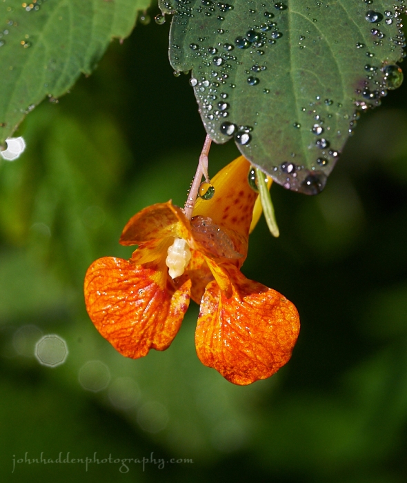
About Today’s Photo:
Jewelweed (Impatiens capensis) is a common flower blooming this time of year. Also known as touch-me-not, the ripened seed pods will explode when lightly touched (something I’ve loved to do since I was a kid!) The deep nectar spurs of the flower are best pollinated by hummingbirds. The juice of the the crushed stems has been used to treat skin rashes (and poison ivy) and works fairly well to calm the itch of nettles.
Nikon D600, Sigma 105mm macro lens, ISO 800, f/13, 1/500″ exposure.
Monday, August 7, 2017

Yellow day lilies by the pond
Morning Observation:
This morning in Huntington at 7:35AM it’s currently 58 degrees under mostly clear skies. Winds are calm. Relative humidity is 98%, dewpoint 57, barometric pressure 30.05” and steady. We picked up 0.02” of rain overnight. Yesterday’s high was 72, and the overnight low was 50.
Forecast:
Low pressure moving out of the Ohio River Valley will bring showers and thunderstorms this afternoon and into the night. We’ll get a brief from rain on Tuesday before more unsettled weather returns for the latter half of the week. After a coolish start temperatures will trend warmer throughout the week.
We’ll see partly sunny skies in the morning, becoming cloudy with a chance of showers and a slight chance of thunderstorms this morning, then showers likely in the afternoon. Highs will be in the lower 70s with light and variable winds, becoming southerly around 10 mph in the afternoon. Chance of rain is 70%. Tonight will be cloudy with showers likely and a slight chance of thunderstorms until midnight, then a chance of showers after midnight. Lows will be in the mid 50s with south winds around 10 mph until midnight, becoming light and variable. Chance of rain is 70%.
Tuesday should be partly sunny with a 30% chance of lingering showers. Highs will be in the lower 70s with northwest winds 10 to 15 mph. Tuesday night should be clear with lows in the lower 50s and southwest winds around 10 mph.
Wednesday’s looking partly sunny with a 40% chance of showers north. Highs will be in the mid 70s. Wednesday night should be partly cloudy with a 40% chance of showers. Lows will be in the upper 50s.
Almanac:
Last year on this date we had a high of 78 and a low of 54. We picked up 0.03″ of rain.
Burlington averages for this date are highs of 80 and lows of 60.
The record high was 95°F in 2001 (we had a high of 91).
The record low was 40°F in 1964.
Sky Notes:
Sunrise: 5:46 AM EDT
Sunset: 8:08 PM EDT
Length of Visible Light: 15h 26m
Length of Day: 14h 22m
Tomorrow will be 2m34s shorter.
The Moon is the full “Sturgeon” moon (Northeast Native American)
15 days old with 100% illumination.
Moonrise: 8:08 PM EDT
Moonset: 5:32 AM EDT
Other names for this month’s full moon include: “Grain” (English), “Dispute” (Celtic), “Wyrt” (Medieval Wiccan), and “Lightning” (Neo-Pagan Wiccan).
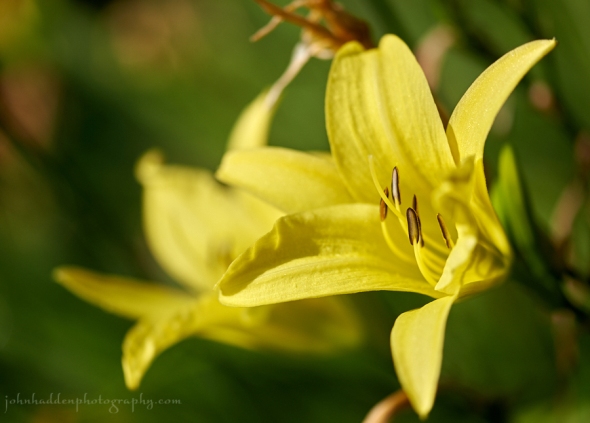
About Today’s Photo:
Our yellow day lilies are popping.
Nikon D600, Sigma 105mm macro lens, ISO 200, f/3.5, 1/3200″ exposure.
Sunday, August 6, 2017

A burst of tiger lilies along Fargo Brook
Morning Observation:
This morning in Huntington at 7:40AM it’s currently a cool 54 degrees under partly cloudy skies. Winds are out of the northwest at 0-3 mph. Relative humidity is 77%, dewpoint a comfortable 50, barometric pressure 29.96” and rising rapidly. We picked up 0.53” of rain in the past 24hrs. Yesterday’s high was 79, and the overnight low was 53.
Forecast:
We’ve got a lovely, albeit a bit cool and breezy day on tap courtesy of high pressure which is building into the region. Low pressure moving out of the Ohio River Vally Monday will bring another round of showers and isolated thunderstorms, followed by dry weather again for Tuesday.
We’ll see partly sunny skies today with highs in the lower 70s and northwest winds 15 to 20 mph gusting up to 30 mph. Tonight should be partly cloudy with lows in the lower 50s and west winds 10 to 15 mph until midnight, becoming light and variable.
Monday should be cloudy with a chance of showers in the morning, then showers likely with a slight chance of thunderstorms in the afternoon. Highs will be in the upper 60s with light and variable winds, becoming southerly around 10 mph in the afternoon. Chance of rain is 70%. Monday night showers are likely. Lows will be in the mid 50s with northeast winds around 10 mph. Chance of rain is 70%.
Tuesday’s looking partly sunny with a 50% chance of lingering showers. Highs will be around 70 with northwest winds 10 to 15 mph. Tuesday night shoud be mostly clear as high pressure builds in. Lows will be in the lower 50s.
Almanac:
Last year on this date we had a high of 82 and a low of 66. We picked up 0.11″ of rain.
Burlington averages for this date are highs of 80 and lows of 60.
The record high was 93°F in 1931.
The record low was 44°F in 1964.
Sky Notes:
Sunrise: 5:45 AM EDT
Sunset: 8:09 PM EDT
Length of Visible Light: 15h 29m
Length of Day: 14h 24m
Tomorrow will be 2m31s shorter.
The Moon is waxing gibbous, 13.4 days old with 98% illumination.
Moonrise: 7:30 PM EDT
Moonset: 4:34 AM EDT
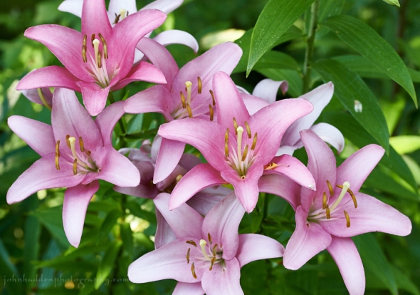
About Today’s Photo:
Robin planted a variety of tiger lilies in a flower bed along Fargo Brook in our back yard. They’re in bursting full bloom right now and quite spectacular (as well as fragrant!)
Nikon D600, Sigma 105mm macro lens, ISO 1250, f/8, 1/250″ exposure.
