Friday, May 31, 2013

A Common Green Darner (?) recently emerged from its naiad larval casing.
Morning Observation:
This morning in Huntington at 6:30AM it’s currently 59 degrees under partly cloudy skies. Winds are calm. Relative humidity is 99%, dewpoint 59, barometric pressure 30.05″ and steady. Yesterday’s high was 85 and the overnight low was 57.
Forecast:
With high pressure in place over the region, we’ll enjoy mid-summer-like conditions today as warm, humid air continues to make its way into the region. It’ll be a warm-to-hot and muggy day today with mostly sunny skies and highs in the upper 80s to near 90 with southwest winds around 10 mph. A few isolated showers may pop up during the afternoon hours over higher elevations east. Tonight should be partly cloudy with isolated showers and thunderstorms. Lows will be in the lower 60s with southwest winds around 10 mph until midnight, becoming light and variable. Chance of rain is 20%.
Saturday should be partly sunny with scattered showers and thunderstorms, mainly in the afternoon, as a slow moving cold front approaches from the Great Lakes. Highs will be in the mid 80s with south winds around 10 mph. Chance of rain is 40%. Saturday night should be partly cloudy with scattered showers and thunderstorms. Lows will be in the mid 60s with south winds around 10 mph. Chance of rain is 40%.
The cold front should move into the region Sunday bringing numerous showers and thunderstorms. Some thunderstorms may produce gusty winds, small hail and heavy rainfall. Highs will be in the lower 80s with south winds 10 to 15 mph gusting up to 25 mph. Chance of rain is 70%. Sunday night showers are likely with a chance of thunderstorms. Lows will be in the upper 50s. Chance of rain is 70%.
Almanac:
Last year on this date we had a high of 69 and a low of 45.
Burlington norms for this date are highs of 72°F and lows of 50°F.
Record high was 90°F in 1944 (we might challenge that today…)
Record low was 25°F in 1961.
Sky Notes:
Sunrise: 5:11 AM EDT
Sunset: 8:28 PM EDT
Length Of Visible Light: 16h 28m
Length of Day: 15h 16m
Tomorrow will be 1m 23s longer.
The Moon is in its last quarter, 21d 10h old with 54% illumination.
Moonrise: 12:51 AM EDT
Moonset: 12:35 PM EDT
About Today’s Photo:
Chalk up another one to being in the right place at the right time. I was poking about in Fargo Brook with my new camera rig yesterday when I came across what I think is a Common Green Darner (Anax junius) that had recently emerged from its larval naiad case. It sat there very patiently as I took numerous shots from a variety of angles. This was the best view as it really shows both the dragonfly and the naiad case. It’s pretty amazing that something that big once fit inside something that small. The wonders of nature! I made the shot hand-held using my Sigma 105mm macro, ISO 500, f/14, 1/40″.
Thursday, May 30, 2013

A dandelion seed head takes on geometric qualities when viewed up close.
Morning Observation:
This morning in Huntington at 6:35AM it’s currently 56 degrees under a partly cloudy skies. Winds are calm. Relative humidity is 99%, dewpoint 56, barometric pressure 30.03″ and rising. We picked up 0.26″ of rain yesterday. Yesterday’s high was 69 and the overnight low was 51.
Forecast:
High pressure will build into the region over the next few days along with warm, moist air bringing us summer-like conditions into the weekend. We’ll see partly sunny skies today with highs around 80 and west winds around 10 mph. Tonight should be mostly clear with patchy fog after midnight. Lows will be in the lower 60s with light and variable winds.
Friday should be partly sunny with a slight chance of showers and thunderstorms in the afternoon as daytime convection interacts with some instability in the airmass. Highs will be in the mid 80s to near 90 with southwest winds around 10 mph. Chance of rain is 20%. Friday night should be partly cloudy with lows in the mid 60s and southwest winds around 10 mph.
Saturday’s looking partly sunny with a chance of showers and thunderstorms in the afternoon as an upper level trough and attendant cold front approach from the Great Lakes. Highs will be in the mid 80s with south winds around 10 mph. Chance of rain is 50%. Saturday night should be partly cloudy with a chance of showers and thunderstorms. Lows will be in the mid 60s. Chance of rain is 50%.
Almanac:
Last year on this date we had a high of 78 and a low of 55. We picked up 0.64″ of rain.
Burlington norms for this date are highs of 72°F and lows of 50°F.
Record high was 92°F in 1929.
Record low was 28°F in 1961.
Sky Notes:
Sunrise: 5:12 AM EDT
Sunset: 8:27 PM EDT
Length Of Visible Light: 16h 26m
Length of Day: 15h 15m
Tomorrow will be 1m 25s longer.
The Moon is waning gibbous, 20d 10h old with 65% illumination.
Moonrise: 12:18 AM EDT
Moonset: 11:26 AM EDT
About Today’s Photo:
I’ve got a new camera! After some five years with my trusty Nikon D90, I just upgraded to a new D600. This photo was the first shot I took with it. I’m sold! One of the things I love about macro (or, more accurately, micro) photography is what happens when you get in really close to an object. This shot was originally of the entire seed head. However, when I zoomed in close to check for focus, I discovered that the way the lacy “parachutes” intertwined reminded me of Buckminsterfullerene—a complex spherical molecule. I think the shot is much more interesting cropped in close. I took the shot using my Sigma 105mm macro, ISO 800, f/16, 1/200″.
Wednesday, May 29, 2013

A rain soaked poppy bud just about to burst in our back garden.
Morning Observation:
This morning in Huntington at 7:05AM it’s currently 55 degrees and raining lightly under overcast skies. Winds are calm. Relative humidity is 98%, dewpoint 54, barometric pressure 30.02″. We picked up 0.14″ of rain overnight. Yesterday’s high was 72 and the overnight low was 51.
Forecast:
A warm front will push through the region today bringing showers with a slight chance of thunderstorms this morning, then occasional showers and thunderstorms this afternoon as a low pressure wave moves along the front. Some thunderstorms may produce damaging winds, hail and heavy rainfall this afternoon. Highs will be around 70 with south winds around 10 mph. Chance of rain is 80%. Tonight should be mostly cloudy with showers and thunderstorms likely until midnight, then become partly cloudy with a chance of showers and a slight chance of thunderstorms after midnight. Lows will be in the upper 50s with southwest winds around 10 mph. Chance of rain is 70%.
By Thursday the region will be enveloped in a summerlike airmass courtesy of a building Bermuda high that will swing warm humid air northward into the weekend. We’ll see partly sunny skies with a slight chance of showers and thunderstorms over higher terrain in the afternoon as diurnal heating kicks in. It’ll be warmer with highs in the lower 80s and west winds around 10 mph. Chance of rain is 20%. Thursday night should be mostly clear with lows around 60 and southwest winds around 10 mph.
Friday’s looking partly sunny and warmer still with highs in the mid 80s and southwest winds 10 to 15 mph. Friday night should be partly cloudy with lows in the lower 60s.
Almanac:
Last year on this date we had a high of 88 and a low of 62. We picked up 0.04″ of rain.
Burlington norms for this date are highs of 71°F and lows of 50°F.
Record high was 89°F in 1978.
Record low was 34°F in 1970.
Sky Notes:
Sunrise: 5:12 AM EDT
Sunset: 8:26 PM EDT
Length Of Visible Light: 16h 24m
Length of Day: 15h 14m
Tomorrow will be 1m 29s longer.
The Moon is waning gibbous, 19d 19h old with 75% illumination.
No Moon Rise
Moonset: 10:14 AM EDT
About Today’s Photo:
We have many “volunteer” poppies growing in one of our backyard flowerbeds. This one is just cracking open to unfurl its crinkly petals (I’m sure there will be a shot of that down the road!) I like the bright splash of red against all the green. I took this shot hand-held with my 105mm macro, ISO 500, f/13, 1/250″.
Tuesday, May 28, 2013

Snow on Mt. Mansfield yesterday afternoon as viewed from Pond Road in Richmond.
Morning Observation:
This morning in Huntington at 7:10AM it’s currently 41 degrees under clear skies. Winds are calm. Relative humidity is 98%, dewpoint 40, barometric pressure 30.21″ and rising. Yesterday’s high was 65 and the overnight low was 35.
Forecast:
The high pressure that gave us yesterday’s sunshine is currently moving off the coast. We’ll see sunny during most of the day today with highs in the lower 70s and light and variable winds, becoming southerly around 10 mph this afternoon. Clouds will begin to filter in this afternoon out ahead of a warm front approaching from the southwest. Tonight should be partly cloudy until midnight, then become cloudy with a chance of showers and a slight chance of thunderstorms after midnight. Lows will be in the mid 50s with south winds around 10 mph. Chance of rain is 50%.
Wednesday showers are likely with a slight chance of thunderstorms in the morning, then occasional showers and thunderstorms in the afternoon. Some thunderstorms may produce gusty winds, small hail and heavy rainfall in the afternoon, and there’s the possibility of some “training” storms similar to those that impacted the region during our last round of thunderstorms. These are storms that act like cars on a train that hit the same region in succession. Highs Wednesday will be in the upper 60s to low 70s with south winds around 10 mph in the morning, becoming light and variable. Chance of rain is 80%. Wednesday night should be cloudy with a chance of showers and thunderstorms. Some thunderstorms may produce gusty winds, small hail and heavy rainfall. Lows will be in the lower 60s with light and variable winds. Chance of rain is 50%.
Thursday’s looking partly sunny and warmer as we’ll be fully enveloped in moist tropical air for remainder of the week. Highs will be in the lower 80s with light and variable winds. Thursday night should be partly cloudy with lows in the mid 60s.
Almanac:
Last year on this date we had a high of 83 and a low of 48.
Burlington norms for this date are highs of 71°F and lows of 49°F.
Record high was 92°F in 1978.
Record low was 30°F in 1961.
Sky Notes:
Sunrise: 5:13 AM EDT
Sunset: 8:25 PM EDT
Length Of Visible Light: 16h 23m
Length of Day: 15h 12m
Tomorrow will be 1m 32s longer.
The Moon is waning gibbous, 18d 11h old with 84% illumination.
Moonrise: 11:42 PM EDT
Moonset: 9:01 AM EDT
About Today’s Photo:
Saturday night’s surprise snowfall was quite dramatic. Mt. Mansfield picked up 13″ at the summit and Whiteface in the Adirondacks picked up a whopping 34″! Luckily, the snow level didn’t reach much below 2500′ where trees are fully leafed out. This shot was taken with my 150-500mm zoom at 150mm, ISO 400, f/8, 1/1000″.
Monday, May 27, 2013

Huntington Gorge running high yesterday afternoon.
Morning Observation:
This morning in Huntington at 6:30AM it’s currently a chilly 34 degrees under clear skies (whaaat?). Winds are calm. Relative humidity is 99%, dewpoint 34, barometric pressure 30.13″ and rising. We picked up 0.13″ of rain in the past 24hrs. Yesterday’s high was 47 and the overnight low was 33.
Total rainfall since Friday from the storm here is 3.65″. Add to that the daily thunderstorms and showers that started on the 20th and we’ve had a total of 6.13″ since last Tuesday. We are pretty sodden.
Forecast:
We will enjoy sunny skies and much warmer temperatures today courtesy of high pressure currently building into the region. Highs today will be in the mid 60s with west winds around 10 mph gusting up to 25 mph and becoming northwesterly this afternoon. Tonight should be clear with patchy frost after midnight. Lows will be in the mid 30s with some possible areas of frost in true cold pockets. Winds will be out of the northwest at around 10 mph until midnight, becoming light and variable.
Tuesday should be sunny and warmer still with highs in the lower 70s and light and variable winds becoming southerly around 10 mph in the afternoon. A broad warm front will approach the region from the southwest Tuesday night bringing partly cloudy skies with a 40% chance of showers. Lows will be in the mid 50s with south winds around 10 mph.
The warm front will move into the region Wednesday bringing mostly cloudy and a 50% chance of showers. Highs will be in the upper 70s to near 80 with south winds 10 to 15 mph. Wednesday night should be mostly cloudy with a chance of showers and thunderstorms. Lows will be in the upper 50s. Chance of rain is 50%.
Looking down the road, we’ll see increasing heat and humidity as a Bermuda high sets up and aids in the funneling of warm humid air up the east coast and into our region. It’ll feel like mid summer by the middle of the week with muggy conditions right into the weekend.
Almanac:
Last year on this date we had a high of 76 and a low of 46.
Burlington norms for this date are highs of 71°F and lows of 49°F.
Record high was 91°F in 1944.
Record low was 28°F in 1969.
Sky Notes:
Sunrise: 5:14 AM EDT
Sunset: 8:24 PM EDT
Length Of Visible Light: 16h 21m
Length of Day: 15h 10m
Tomorrow will be 1m 36s longer.
The Moon is waning gibbous, 17d 10h old with 92% illumination.
Moonrise: 10:59 PM EDT
Moonset: 7:49 AM EDT
About Today’s Photo:
The notorious and picturesque Huntington Gorge is a great place to take pictures, especially when the water is high. With all the rain we’ve had over the past many days (and it seems like many many…) I knew the water would be roaring through the limestone channel. With rain-slicked rocks, moving around above the cataract was a bit tricky, and the continuing rain and wind made shooting a challenge. Worth it though I think!
I took the shot hand-held using my Nikon 18-105mm zoom @ 18mm, ISO 100, f/14, 1/8″ shutter. One of the best things about the newer optical stabilization lenses is that you can shoot hand-held without a tripod down to 1/8″ if you’re steady. This shot is a good example. I was able to get the flow of the water nicely without the hassle of setting up a tripod on the slick rocks. Of course, a 2″-4″ exposure might have been a tad better–smoothing out the water even more–but I’m happy with this shot all things considered.
Sunday, May 26, 2013

White Pine “candles” in the afternoon light.
Morning Observation:
This morning in Huntington at 9:30AM it’s currently a raw 41 degrees and still raining under overcast skies. Winds are out of the south at 0-3 mph. Relative humidity is 96%, dewpoint 40, barometric pressure 29.91″ and rising slowly. We picked up 1.48″ of rain in the past 24hrs. Yesterday’s high was 44 and the overnight low was 36.
A Flood Watch remains in effect for our region until 10:30AM this morning, especially for areas just to our north along the Lamoille River in Jeffersonville and portions of Jericho that were hit hard just a few days ago. Watch out for high water!
Forecast:
We’ve got another chilly, rainy day on tap today as the coastal low continues to pump cold moist air into the region. We’ll see rain this morning tapering to showers this afternoon. Highs will only be in the upper 40s with northwest winds 15 to 20 mph gusting up to 30 mph. Chance of rain near is 100%. Tonight will be partly cloudy with a chance of showers until midnight, then clearing after midnight as the low finally moves off to northeast and high pressure begins to build into the region from the northwest. Lows will be in the upper 30s with west winds 10 to 15 mph gusting up to 25 mph until midnight, becoming light and variable in the early morning hours. Chance of rain is 40%. We can expect another 0.50″ to 0.75″ of rain out of this storm before the spigot finally shuts off overnight. There is the possibility of frost early Monday morning.
High pressure will move into the region Memorial Day bringing sunny and moderating temperatures. Highs should be in the lower 60s by later in the day with northwest winds 10 to 15 mph gusting up to 25 mph. Monday night should be clear with lows around 40 and southwest winds around 10 mph.
Tuesday’s looking sunny with highs in the lower 70s and south winds around 10 mph. Tuesday night should be mostly clear with lows in the lower 50s. Things are looking more “normal” going forward into the middle of the week.
Almanac:
Last year on this date we had a high of 71 and a low of 53. We picked up 0.67″ of rain.
Burlington norms for this date are highs of 70°F and lows of 49°F.
Record high was 92°F in 2010 (we had a high of 88).
Record low was 32°F in 1969.
Sky Notes:
Sunrise: 5:14 AM EDT
Sunset: 8:23 PM EDT
Length Of Visible Light: 16h 19m
Length of Day: 15h 09m
Tomorrow will be 1m 39s longer.
The Moon is waning gibbous, 16d 13h old with 97% illumination.
Moonrise: 10:07 PM EDT
Moonset: 6:41 AM EDT
About Today’s Photo:
I’ve always enjoyed the term “candle” when referring to the new growth of white pine trees. The way the pale green pops out against the darker green of the pine’s mature needles is indeed reminiscent of candles burning. This shot was taken with my 55-300mm telephoto @ 270mm, ISO 1250, f/8, 1/50″.
Saturday, May 25, 2013
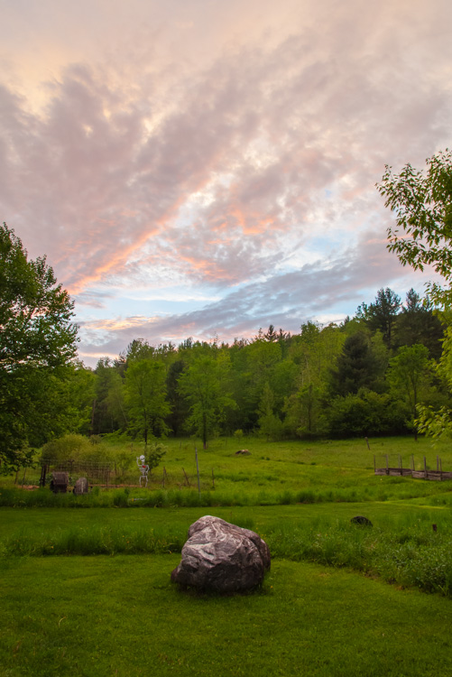
Sunset colors over our front field last Wednesday evening.
Morning Observation:
This morning in Huntington at 6:25AM it’s currently a soggy 42 degrees and raining under overcast skies. Winds are out of the south at 1-4 mph. Relative humidity is 95%, dewpoint 40, barometric pressure 29.95″. We picked up 1.31″ of rain in the past 24hrs. Yesterday’s high was 50 and the overnight low was 41.
There is a Flood Watch in effect for our region until Sunday afternoon.
Forecast:
We’ll be under the gun of a deep trough of coastal low pressure–a May nor’easter–for another 24 to 36 hours. The low will continue to rotate moisture and chilly air off the Gulf of Maine and into our region. Today we’ll see rain with highs only in the lower 40s and north winds 15 to 20 mph. Chance of rain is near 100%. Rain will continue unabated into tonight with the likelihood of snow above 2000′. Expect little or no snow accumulation at more residential elevations, however mountain summits could see as much as 6″ of heavy snow. Overnight lows will be in the upper 30s with northwest winds 15 to 20 mph. Chance of precipitation is near 100%.
Rain will continue into Sunday morning, then slowly taper off to showers in the afternoon as the low moves off the coast. Highs will be in the upper 40s with northwest winds 15 to 20 mph. Chance of rain is near 100%. Sunday night should be partly cloudy with a 40% chance of showers. Lows will be in the upper 30s with west winds around 10 mph. We can expect at least another 1.5″-2″ of rain out of this storm before it’s all done, with as much as 3″ possible along the western slopes of the Greens.
High pressure will build in for Memorial Day bringing mostly sunny skies with highs in the mid 60s and northwest winds 10 to 15 mph gusting up to 25 mph. Monday night should be clear with lows in the upper 30s.
Almanac:
Last year on this date we had a high of 77 and a low of 62.
Burlington norms for this date are highs of 70°F and lows of 48°F.
Record high was 91°F in 1946.
Record low was 28°F in 1956.
Sky Notes:
Sunrise: 5:15 AM EDT
Sunset: 8:23 PM EDT
Length Of Visible Light: 16h 17m
Length of Day: 15h 07m
Tomorrow will be 1m 42s longer.
The Moon is the full “Flower” moon (Northeast Native American)
15d 10h old with 100% illumination (not that we’ll see it…)
Moonrise: 9:07 PM EDT
Moonset: 5:40 AM EDT
Other names for this full moon include: “Milk” (Colonial American & English), “Bright” (Celtic), “Hare” (Medieval Wiccan), and “Grass” (Neo Pagan Wiccan).
There’s a lovely planetary conjunction occurring in the western sky after sunset over the next several days. The planets Mercury, Jupiter and Venus will be clustered close to each other on the western horizon shortly after sunset from now until the 29th. A good time to check will be Monday night at around 9:00PM, and you’ll need a clear shot to the western horizon as they’ll be quite low in the sky. Good luck!
About Today’s Photo:
This photo was taken last Wednesday evening out in our front yard as we got a break in the clouds between thunderstorms and showers. The now sodden volleyball court, lower garden and our new scare-skeleton (thanks Gary!) can be seen. I really like the richness and variety of the greens and detail in the sky. We live in a lovely place!
I took the shot using my 18-105mm zoom @ 18mm, ISO 800, f/11, 1/30 shutter, and a polarizing filter. I tweaked it a bit in Lightroom to balance out the darker foreground and draw some more saturated color out of the sky. Lightroom is an amazing tool allowing for near HDR (high dynamic range) photography from a single shot.
Friday, May 24, 2013
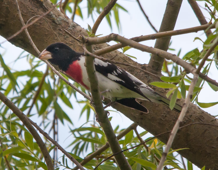
A Rose-Breasted Grosbeak perched high in a willow along Fargo Brook.
Morning Observation:
This morning in Huntington at 6:10AM it’s currently 50 degrees and raining lightly under overcast skies. Winds are calm. Relative humidity is 97%, dewpoint 49, barometric pressure 29.71″ and rising. We picked up 0.73″ of rain in the past 24hrs. Yesterday’s high was 77 and the overnight low was 50.
Forecast:
A developing coastal low–similar to a wintertime nor’easter–will bring more rain and much cooler temperatures to our region over the weekend. Temperatures will be 15 to 20 degrees below normal with some high elevation accumulating snowfall possible on Saturday into Sunday. Quite a change, no?
Today we’ll see showers and near steady temperature in the upper 40s and lower 50s with north winds 10 to 15 mph. Chance of rain is near 100%. Tonight will bring more rain with lows in the lower 40s and north winds 10 to 15 mph. Chance of rain is near 100%.
Saturday will bring more rain with highs in the mid 40s and north winds 10 to 15 mph. Chance of rain is near 100%. Saturday night? More rain with lows in the upper 30s and north winds 15 to 20 mph gusting up to 30 mph. Chance of rain is near 100%. There’s a strong probability of accumulating snowfall in areas above 2500′ Saturday night into Sunday morning. Forecasts are calling for as much as 6″ in the ‘Dacks, Mt. Mansfield and Jay Peak. Zoweee!
Rain will continue into Sunday with highs only in the mid 40s and northwest winds 15 to 20 mph gusting up to 30 mph. Chance of rain is near 100%. The low should finally move off the coast Sunday night, so we should see mostly cloudy skies with a 40% chance of rain. Lows will be in the upper 30s. High pressure will build into the region Monday, moderating temperatures into the lower 60. All in all, it’s gunna be a chilly, soggy and raw weekend folks. Rainfall totals should be on the order of 2″ to 2.5″ by the time the low leaves us. Guess we’re getting the rain we so needed just last week… Never a dull moment here in the North Country!
Almanac:
Last year on this date we had a high of 80 and a low of 53.
Burlington norms for this date are highs of 70°F and lows of 48°F.
Record high was 88°F in 1991.
Record low was 28°F in 1963.
Sky Notes:
Sunrise: 5:16 AM EDT
Sunset: 8:22 PM EDT
Length Of Visible Light: 16h 15m
Length of Day: 15h 05m
Tomorrow will be 1m 46s longer.
The Moon is waxing gibbous, 14d 10h old with 99% illumination.
Moonrise: 7:59 PM EDT
Moonset: 4:48 AM EDT
About Today’s Photo:
I was out getting some first shots with my new Sigma 150-500mm telephoto lens yesterday afternoon. I heard one of our resident Northern Orioles up in the trees along the brook and was trying to catch a shot of it. I saw some movement and slew the big lens towards it, and there was this male Rose-Breasted Grosbeak (Pheucticus ludovicianus)! Quite the handsome fellow! The shot was taken with my 150-500mm tele @ 500mm, ISO 800, f/14, 1/800 second.
Thursday, May 23, 2013
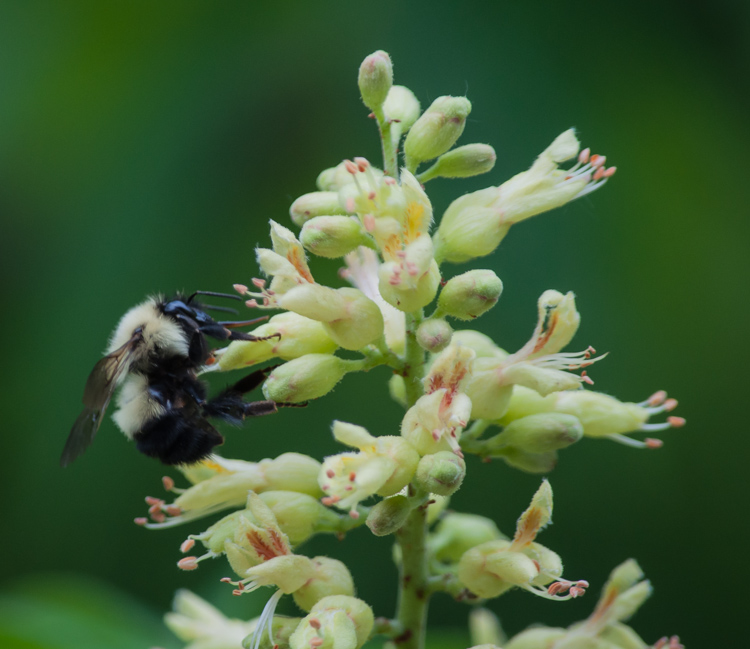
A bumble bee busies the buckeye blossoms by the back deck. Beautiful!
Morning Observation:
This morning in Huntington at 6:35AM it’s currently 65 degrees under mostly cloudy skies. Winds are calm. Relative humidity is 98%, dewpoint 64, barometric pressure 29.73″ and rising. We picked up 0.90″ of rain in the past 24hrs. Yesterday’s high was 79 and the overnight low was 62.
There’s a Flash Flood Warning in effect for the Adirondack and all of Vermont from noon today to Friday morning.
Forecast:
More rain in the forecast today. We’ll see scattered showers with isolated thunderstorms this morning, then more showers and thunderstorms this afternoon out ahead of an upper level low and associated cold front. Some thunderstorms may produce gusty winds and heavy rainfall this afternoon. Highs will be in the mid 70s with south winds 10 to 15 mph gusting up to 25 mph this afternoon. Chance of rain is 90%. Showers and thunderstorms will continue into tonight with some thunderstorms may producing gusty winds and heavy rainfall. Lows will be in the mid 50s with southwest winds around 10 mph and gusting up to 25 mph. Chance of rain is near 100%. Rainfall rates for this system may be as much as 1 to 2 inches per hour, so flash floods are a concern.
The upper level low will move over the region early Friday and then stall bringing more showers and thunderstorms in the morning, then occasional showers with isolated thunderstorms in the afternoon. The air behind this front is significantly cooler, and highs Friday will only be in the upper 50s with north winds 10 to 15 mph. Chance of rain is 90%. Friday night will bring numerous showers. Lows will be in the mid 40s with northwest winds 10 to 15 mph gusting up to 25 mph. Chance of rain is 70%.
Saturday’s looking cloudy with scattered showers. Highs will only be in the mid 50s with north winds 10 to 15 mph gusting up to 25 mph. Chance of rain is 50%. Saturday night should be cloudy with scattered showers. Lows will be in the lower 40s. Chance of rain is 50%. Sunday’s still looking showery, but Memorial Day should be sunny with highs in the mid 60s.
Almanac:
Last year on this date we had a high of 71 and a low of 53. We picked up 0.67″ of rain.
Burlington norms for this date are highs of 69°F and lows of 48°F.
Record high was 91°F in 1975.
Record low was 31°F in 1935.
Sky Notes:
Sunrise: 5:17 AM EDT
Sunset: 8:21 PM EDT
Length Of Visible Light: 16h 13m
Length of Day: 15h 03m
Tomorrow will be 1m 49s longer.
The Moon is waxing gibbous, 13d 10h old with 96% illumination.
Moonrise: 6:47 PM EDT
Moonset: 4:04 AM EDT
About Today’s Photo:
Sorry for the alliteration… The buckeye tree by our back deck is a profusion of flowers this time of year, and it consequently attracts all kinds of pollinators. This bumble bee was just one of many working the blossoms yesterday morning. The shot was taken with my 55-300mm zoom at 300mm, ISO 500, f/5.6, 1/320 shutter.
Wednesday, May 22, 2013

A wild strawberry blossom opened wide along Fargo Brook.
Morning Observation:
This morning in Huntington at 6:25AM it’s currently a juicy 59 degrees under overcast skies. Winds are calm. Relative humidity is 98%, dewpoint 59, barometric pressure 29.80″. We picked up 0.77″ of rain during last night’s thunderstorm that cruised through at around 8:30PM. Yesterday’s high was 70 and the overnight low was 56.
I really enjoyed watching the storm come through yesterday evening. There were clouds streaming northward over the mountains as the cold front came slamming in from the west bringing the rain, thunder and lightning. I’d never really seen such a dramatic presentation of two air masses interacting before. Quite impressive!
Forecast:
More rain and thunderstorms in the picture for us over the next few days. We’ll see mostly cloudy with a chance of showers and thunderstorms late this afternoon as a warm front lifts northeastward this afternoon. Some thunderstorms may produce small hail, gusty winds and locally heavy downpours. Highs will be in the mid 70s with south winds around 10 mph this morning, becoming light and variable. Chance of rain is 30%. Tonight will be cloudy with showers and thunderstorms likely mainly until midnight. Lows will be in the lower 60s with south winds around 10 mph. Chance of rain is 60%.
A slow moving cold front will move into the region from the Great Lakes on Thursday bringing showers and thunderstorms. Some thunderstorms may produce heavy rainfall. Highs will be in the mid 70s with south winds 10 to 15 mph. Chance of rain is 90%. Showers and thunderstorms will continue into Thursday night with some thunderstorms producing heavy rainfall. Lows will be in the lower 50s with west winds 10 to 15 mph. Chance of rain is 90%. We could see additional rainfall totals of over 2″ before things lighten up a bit on Friday.
Friday showers are likely. It will be cooler with highs in the lower 60s and north winds 10 to 15 mph. Chance of rain is 60%. Friday night should be mostly cloudy with a 40% chance of showers. Lows will be in the lower 40s.
Almanac:
Last year on this date we had a high of 72 and a low of 60. We picked up 0.02″ of rain.
Burlington norms for this date are highs of 69°F and lows of 47°F.
Record high was 93°F in 1977.
Record low was 31°F in 1936.
Sky Notes:
Sunrise: 5:17 AM EDT
Sunset: 8:20 PM EDT
Length Of Visible Light: 16h 11m
Length of Day: 15h 02m
Tomorrow will be 1m 51s longer.
The Moon is waxing gibbous, 12d 10h old with 90% illumination.
Moonrise: 5:34 PM EDT
Moonset: 3:26 AM EDT
About Today’s Photo:
Following up on yesterday’s post of an opening wild strawberry blossom, I figured it was only fair to show one in its full glory! The shot was taken with my 105mm macro, ISO 1250, f/11, 1/250 shutter.
Tuesday, May 21, 2013

A wild strawberry blossom opening up along Fargo Brook.
Morning Observation:
This morning in Huntington at 6:30AM it’s currently a juicy 60 degrees under overcast skies. Winds are calm. Relative humidity is 98%, dewpoint 60, barometric pressure 29.83″ and falling. We picked up 0.46″ of rain overnight and had some lovely thunder-boomers kicking up at around 4:15AM this morning. Yesterday’s high was 70 and the overnight low was 52.
Forecast:
We’ll see an active next couple of days as waves of low pressure move eastward along a stationary front that’s pretty much right on top of us. Today we’ll see mostly cloudy skies with a chance of thunderstorms and occasional showers mainly this morning as an area of low pressure tracks eastward across southeastern Ontario. Highs will be in the upper 60s with southeast winds around 10 mph this morning, becoming light and variable. Chance of rain is 90%. Tonight will bring occasional showers and a chance of thunderstorms mainly until midnight as the frontal boundary shifts northward as a warm front. Lows will be in the mid 50s with southeast winds around 10 mph. Chance of rain is 90%.
Wednesday should start out cloudy in the morning then become partly sunny. There’s a chance of thunderstorms in the afternoon as diurnal heating acts on the moist airflow over the region. Highs will be in the upper 70s to low 80s with south winds around 10 mph. Chance of rain is 70%. Wednesday night should be partly cloudy with a chance of showers. Lows will be in the lower 60s with south winds around 10 mph. Chance of rain is 50%.
Thursday will bring occasional showers with a chance of thunderstorms as a cold front tilts into the region. Highs will be in the mid 70s with south winds 10 to 15 mph gusting up to 30 mph. Chance of rain is 80%. Thursday night should bring more showers and a chance of thunderstorms. Lows will be in the lower 60s. Chance of rain is 70%. We should see over an inch of rain from all of this by Thursday evening with locally higher totals due to heavier downpours.
Almanac:
Last year on this date we had a high of 80 and a low of 52.
Burlington norms for this date are highs of 69°F and lows of 47°F.
Record high was 92°F in 1911.
Record low was 29°F in 1964.
Sky Notes:
Sunrise: 5:18 AM EDT
Sunset: 8:19 PM EDT
Length Of Visible Light: 16h 09m
Length of Day: 15h 00m
Tomorrow will be 1m 54s longer.
The Moon is waxing gibbous, 11d 10h old with 82% illumination.
Moonrise: 4:21 PM EDT
Moonset: 2:54 AM EDT
About Today’s Photo:
We have a proliferation of wild strawberry along Fargo Brook. This little blossom was just beginning to open. I really like the fine hairs on the stem. The shot was taken with my 105mm macro, ISO 1250, f/10, 1/250 shutter.
Monday, May 20, 2013

Solomon’s Seal blooming down by Fargo Brook.
Morning Observation:
This morning in Huntington at 6:30AM it’s currently a balmy 58 degrees under overcast skies. Winds are calm. Relative humidity is 92%, dewpoint 55, barometric pressure 29.99″ and falling. We picked up something of a surprise 0.35″ of rain yesterday evening. Yesterday’s high was 67 and the overnight low was 55.
Forecast:
Thanks to a stalled frontal boundary lingering over the region, we’ll see active weather across the region this week with several rounds of rain anticipated and a few thunderstorms possible as well. Today we’ll have cloudy skies with a slight chance of showers this morning, then partly sunny skies this afternoon. Highs will be on the warm side in the mid to upper 70s with light and variable winds becoming northwesterly around 10 mph this afternoon. Chance of rain is 20%. Tonight should be mostly cloudy with a chance of showers after midnight. Lows will be in the mid 50s with light and variable winds. Chance of rain is 30%.
Tuesday should be cloudy with a chance of showers in the morning, then showers likely with a chance of thunderstorms in the afternoon as several waves of low pressure slide along the stalled frontal boundary. Highs will be in the lower 70s with south winds around 10 mph. Chance of rain is 70%. Tuesday night showers are likely with a chance of thunderstorms. Lows will be in the mid 50s with south winds around 10 mph. Chance of rain is 70%.
Showers and the chance of thunderstorms continue into Wednesday with highs in the upper 70s and south winds 10 to 15 mph. Chance of rain is 70%. Wednesday night showers are likely. Lows will be around 60. Chance of rain is 70%.
Almanac:
Last year on this date we had a high of 89(!) and a low of 48.
Burlington norms for this date are highs of 69°F and lows of 47°F.
Record high was 91°F in 1975.
Record low was 30°F 2002 (we had a low of 31).
Sky Notes:
Sunrise: 5:19 AM EDT
Sunset: 8:18 PM EDT
Length Of Visible Light: 16h 06m
Length of Day: 14h 58m
Tomorrow will be 1m 58s longer.
The Moon is waxing gibbous, 10d 10 old with 73% illumination.
Moonrise: 3:12 PM EDT
Moonset: 2:24 AM EDT
About Today’s Photo:
This Solomon’s Seal is a cultivar that I planted in our little wildflower garden down by the brook several years back. Now it grows lush and tall every spring. I really like the rich green textures of the leaves and the pendulous flowers. The photo was taken with my 105mm macro, ISO 1250, f/14, 1/250 sec shutter.
Sunday, May 19, 2013
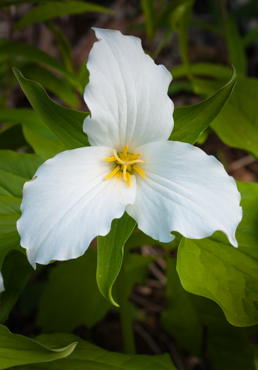
Large-flowered trillium blooming in Monkton.
Morning Observation:
This morning in Huntington at 9:00AM it’s currently 60 degrees under thin, hazy overcast skies. Winds are out of the west at 0-3 mph. Relative humidity is 71%, dewpoint 51, barometric pressure 30.25″. Yesterday’s high was 72 and the overnight low was 43.
Forecast:
We’ll see partly sunny this morning, then mostly cloudy skies with a very slight chance of showers this afternoon. Highs will be around 70 with south winds 10 to 15 mph. Chance of rain is 20%. Tonight should be mostly cloudy with a 20% chance of showers. Lows will be in the lower 50s with south winds 10 to 15 mph gusting up to 25 mph.
Monday should be mostly cloudy in the morning, then become partly sunny. There’s a slight chance of showers and thunderstorms in the afternoon as a weak trough descents from the northwest. Highs will be in the upper 70s with southwest winds around 10 mph in the morning, becoming light and variable. Chance of rain is 20%. Monday night should be partly cloudy with lows in the lower 50s and light and variable winds.
Tuesday’s looking partly sunny with highs in the lower 70s and light and variable winds. Tuesday night should be partly cloudy with a 40% chance of showers. Lows will be in the upper 40s.
Almanac:
Last year on this date we had a high of 82 and a low of 40.
Burlington norms for this date are highs of 68°F and lows of 46°F.
Record high was 91°F in 1989.
Record low was 31°F in 1987.
Sky Notes:
Sunrise: 5:20 AM EDT
Sunset: 8:16 PM EDT
Length Of Visible Light: 16h 04m
Length of Day: 14h 56m
Tomorrow will be 2m 0s longer.
The Moon is waxing gibbous, 9d 12h old with 64% illumination.
Moonrise: 2:05 PM EDT
Moonset: 1:56 AM EDT
About Today’s Photo:
This large-flowered trillium (Trillium grandiflorum) was one of many growing in small groups along the road between Monkton Ridge and the Monkton Elementary School. A very stately flower indeed! The shot was taken using my 105mm macro, ISO 400, f/13, 1/200 sec shutter.
Saturday, May 18, 2013

A wood anemone blooming along Fargo Brook.
Morning Observation:
This morning in Huntington at 7:00AM it’s currently a cool 39 degrees under clear skies. Winds are calm. Relative humidity is 98%, dewpoint 38, barometric pressure 30.28″ and rising. Yesterday’s high was 64, and the overnight low was 36.
Forecast:
High pressure continues to build into the region from the northwest and will deliver a sunny day with highs around 70 and light and variable winds, becoming northwesterly around 10 mph this afternoon. Tonight should be partly cloudy with lows in the mid 40s and light and variable winds.
Sunday should be partly sunny with highs in the lower 70s and light and variable winds, becoming southerly around 10 mph in the afternoon. Moist southerly airflow and some surface instability may kick off a few showers over the higher elevations in the afternoon, though they shouldn’t amount to much. Sunday night should be mostly cloudy and mild with lows only in the mid 50s and south winds around 10 mph.
Monday’s looking mostly cloudy with highs in the mid 70s and southwest winds around 10 mph. Monday night should be partly cloudy and mild again with lows in the upper 50s.
Almanac:
Last year on this date we had a high of 72 and a low of 34.
Burlington norms for this date are highs of 68°F and lows of 46°F.
Record high was 89°F in 1962.
Record low was 29°F in 1983.
Sky Notes:
Sunrise: 5:21 AM EDT
Sunset: 8:15 PM EDT
Length Of Visible Light: 16h 02m
Length of Day: 14h 54m
Tomorrow will be 2m 3s longer.
The Moon is in its first quarter, 8d 10h old with 53% illumination.
Moonrise: 1:01 PM EDT
Moonset: 1:28 AM EDT
About Today’s Photo
Wood Anemone (Anemone quinquefolia) is another lovely, though understated spring wildflower. They can grow in pretty large clumps along woodland fringes with their low growing foliage making a fine, soft carpet on the forest floor. This particular flower was one of a couple dozen growing in a group right next to Fargo Brook. The shot was taken with my 105mm macro, ISO 1250, f/5.6, 1/1600 sec shutter (it was a bit breezy and I was trying to freeze the action.)
Friday, May 17, 2013

A yellow bellied sapsucker finds a loud place to peck!
Morning Observation:
This morning in Huntington at 7:15AM it’s currently 45 degrees under overcast skies. Winds are calm. Relative humidity is 95%, dewpoint 44, barometric pressure 30.02″ and rising rapidly. We picked up 0.02″ of rain overnight. Yesterday’s high was 74 and the overnight low was 44.
Forecast:
This morning’s cloudy skies should give way to partly sunny skies later in the day as high pressure builds into the region for the weekend. Highs today will be in the mid 60s with northwest winds 10 to 15 mph. Tonight should be mostly clear and chilly with lows in the upper 30s and north winds around 10 mph until midnight becoming light and variable.
Saturday should be mostly sunny with highs around 70 and light and variable winds becoming northerly around 10 mph in the afternoon. Saturday night should be partly cloudy with lows in the lower 40s and east winds around 10 mph.
Sunday’s looking partly sunny with highs in the lower 70s and south winds 10 to 15 mph gusting up to 25 mph. Sunday night should be mostly cloudy with lows around 50.
Almanac:
Last year on this date we had a high of 63 and a low of 39. We picked up 0.66″ of rain.
Burlington norms for this date are highs of 68°F and lows of 46°F
Record high was 90°F in 1977.
Record low was 29°F in 1957.
Sky Notes:
Sunrise: 5:22 AM EDT
Sunset: 8:14 PM EDT
Length Of Visible Light: 16h 00m
Length of Day: 14h 52m
Tomorrow will be 2m 6s longer.
The Moon is a waxing crescent, 7d 10h old with 43% illumination.
Moonrise: 11:58 AM EDT
Moonset: 1:00 AM EDT
About Today’s Photo:
This Yellow-Bellied Sapsucker has found a nice loud place to tap away at in the gable end of our garden shed, alternating between the wooden siding and the metal roofing. The males do this to attract a mate apparently and they do make a racket! Another distinctive behavior of this species is the drilling of rows of holes in various trees (apple, birch, pines, etc.) They do this not to get at something under the bark, but to attract insects that then get trapped by the sap. The birds then return for a treat! This shot was taken with my 55-300mm zoom at 300mm, ISO 1250, f/6.3, 1/500 sec shutter.
Thursday, May 16, 2013

A thin-legged wolf spider patrols the rocks and leaf litter along Fargo Brook.
Morning Observation:
This morning in Huntington at 6:40AM it’s currently 42 degrees under clear skies. Winds are calm. Relative humidity is 98%, dewpoint 41, barometric pressure 29.64″ and rising. We picked up 0.04″ of rain yesterday. Yesterday’s high was 65 and the overnight low was 41.
Forecast:
A weak mid-level low will rotate through eastward across southern Québec and into northern Maine today. We’ll start the day with partly sunny skies giving was to a slight chance of showers this afternoon, mostly over northern regions. Highs will be in the upper 60s with southwest winds 15 to 20 mph becoming westerly this afternoon and gusting up to 35 mph. Chance of rain is 20%. Tonight should be mostly cloudy with a slight chance of showers until midnight. Lows will be in the lower 40s with northwest winds 10 to 15 mph until midnight then becoming light and variable. Chance of rain is 20%.
High pressure will build in Friday bringing partly sunny skies with highs in the mid 60s and northwest winds 10 to 15 mph. Friday night should be mostly clear with lows in the lower 40s and southwest winds around 10 mph.
Saturday’s looking partly sunny with highs around 70 and north winds around 10 mph. Saturday night should partly cloudy with lows in the upper 40s.
Almanac:
Last year on this date we had a high of 79 and a low of 53. We picked up 0.54″ of rain.
Burlington norms for this date are highs of 67°F and lows of 45°F.
Record high was 88°F in 1932.
Record low was 29°F in 1936.
Sky Notes:
Sunrise: 5:23 AM EDT
Sunset: 8:13 PM EDT
Length Of Visible Light: 15h 57m
Length of Day: 14h 50m
Tomorrow will be 2m 7s longer.
The Moon is a waxing crescent, 6d 10h old with 33% illumination.
Moonrise: 10:58 AM EDT
Moonset: 12:29 AM EDT
About Today’s Photo:
I love “hunting” insects and spiders with my camera. I was out yesterday shooting more spring wildflowers along Fargo Brook when this little guy caught my eye as he scurried amongst the rocks and leaves along the brook. I’m pretty sure it’s a thin-legged wolf spider, a fairly ubiquitous species throughout North America inhabiting a range of habitats. I like the gleam in his eyes… I shot the photo with my 105mm macro, ISO 1250, f/11, 1/250 sec shutter.
Wednesday, May 15, 2013

A fern unfurls by Fargo Brook.
Morning Observation:
This morning in Huntington at 6:45AM it’s currently 30 degrees under clear skies. We have a pretty decent frost on the ground. Winds are calm. Relative humidity is 97%, dewpoint 29, barometric pressure 30.00″ and falling. Overnight low was 28 and yesterday’s high was 56.
Forecast:
The high pressure and chilly Canadian air that have been over the region the past couple of days will move off the coast this morning. We’ll see mostly sunny skies this morning followed by mostly cloudy skies with rain showers likely this afternoon as a warm front approaches from the southwest. Highs will be in the mid 60s today with south winds 15 to 20 mph and gusting to 35 mph this afternoon. Chance of rain is 60%. Tonight will be cloudy with showers likely until midnight then partly cloudy with a chance of showers after midnight. Lows will be in the upper 40s with southwest winds 15 to 20 mph. Chance of rain is 60%. We should see light precipitation with this front on the order of a quarter inch or so.
Thursday should start off partly sunny in the morning then becoming mostly cloudy with scattered showers as a closed upper low moves along the Québec border. Highs will be in the upper 60s with west winds 15 to 20 mph gusting up to 35 mph. Chance of rain is 40%. Thursday night should be mostly cloudy with a 40% chance of showers. Lows will be in the lower 40s with northwest winds 10 to 15 mph with gusts up to 25 mph.
High pressure will build in Friday bringing partly sunny skies with highs in the mid 60s and northwest winds 10 to 15 mph. Friday night should be partly cloudy with lows in the upper 40s.
Almanac:
Last year on this date we had a high of 63 and a low of 57. We picked up 0.19″ of rain.
Burlington norms for this date are highs of 67°F and lows of 45°F.
Record high was 88°F in 1961.
Record low was 28°F in 1913.
Sky Notes:
Sunrise: 5:24 AM EDT
Sunset: 8:12 PM EDT
Length Of Visible Light: 15h 55m
Length of Day: 14h 47m
Tomorrow will be 2m 11s longer.
The Moon is a waxing crescent, 5d 10h old with 25% illumination.
Moonrise: 9:59 AM EDT
No Moon Set
About Today’s Photo:
I love ferns. Something about their “ancientness”–the way they unfurl in the spring and the texture they give the understory during the summer–that appeals to me. I’m not sure what this species of fern is. Perhaps someone can identify it? The shot was taken with my 105mm macro lens, ISO 800, f/7.1, 1/30 sec shutter.
Tuesday, May 14, 2013

Foamflower blooming across Fargo Brook.
Morning Observation:
This morning in Huntington at 7:30AM it’s currently 37 degrees under partly sunny skies. Winds are calm. Relative humidity is 98%, dewpoint 36, barometric pressure 30.10″ and rising. We picked up 0.01″ of rain in the past 24hrs and a bit of a snow/graupel shower yesterday morning at around 9:15AM. Yesterday’s high was 48 and the overnight low got down to 30. We seem to have avoided any frosting here.
Forecast:
High pressure building into the region this morning will bring us a partly sunny day. Highs will be in the upper 50s with northwest winds 10 to 15 mph. Tonight should be mostly clear with patchy frost after midnight. Lows will be in the lower 30s with north winds around 10 mph until midnight, becoming light and variable.
Wednesday should be mostly sunny in the morning then become mostly cloudy with a chance of rain showers in the afternoon as a warm front approaches from the southwest. Highs will be in the mid 60s with south winds 10 to 15 mph gusting up to 25 mph. Chance of rain is 50%. Wednesday night showers are likely. Lows will be in the upper 40s with southwest winds 15 to 20 mph gusting up to 30 mph. Chance of rain is 60%. Rainfall totals should be on the order of a quarter inch or so. A cold front will swing through late Wednesday night bringing partial clearing.
A closed upper level low will swing through southern Québec Thursday bringing partly sunny and a 30% chance of showers. Highs will be around 70 with west winds 15 to 20 mph gusting up to 35 mph. Thursday night should be partly cloudy with lows in the mid 40s.
Almanac:
Last year on this date we had a high of 72 and a low of 48.
Burlington norms for this date are highs of 67°F and lows of 45°F.
Record high was 86°F in 1961.
Record low was 30°F in 1965.
Sky Notes:
Sunrise: 5:25 AM EDT
Sunset: 8:11 PM EDT
Length Of Visible Light: 15h 52m
Length of Day: 14h 45m
Tomorrow will be 2m 13s longer.
The Moon is a waxing crescent, 4d 11h old with 17% illumination.
Moonrise: 9:03 AM EDT
Moonset: 11:55 PM EDT
About Today’s Photo:
Foamflower, Tiarella cordifolia, also know as False Miterwort, (for some reason I’ve always called it “sea foam” which is apparently wrong…) is quite prolific in rich woodland soils this time of year. I’ve always loved its delicate spray-like flowers. This shot was taken with my 105mm macro, ISO 1250, f/10, 1/30 sec shutter.
Monday, May 13, 2013

Amelanchier blooming along Taft Road.
Morning Observation:
This morning in Huntington at 6:45AM it’s currently a blustery 38 degrees under partly cloudy skies. Winds are out of the west at 5-8 mph and gusting to 15 mph. Relative humidity is 66%, dewpoint 28, barometric pressure 29.80″ and rising slowly. We picked up 0.02″ of rain in the past 24hrs. Yesterday’s high was 58 and the overnight low was 38.
There is a Frost Warning in effect for the Champlain Valley for tonight until 8:00AM Tuesday morning.
Forecast:
An upper level low will continue to move eastward across southeastern Quebec today bringing in colder air to the region. We’ll see partly sunny skies this morning with isolated rain showers this afternoon. Highs will only be in the lower 50s with southwest winds 15 to 20 mph. Chance of rain is 20%. It should be partly cloudy until midnight tonight, then clearing as high pressure builds in with areas. Lows will be in the lower 30s with west winds 10 to 15 mph until midnight, becoming light and variable. Expect widespread frost by morning so if you’ve got tender stuff in the ground, you should cover it up!
Tuesday should start out with patchy frost in the morning. It’ll be sunny with highs in the upper 50s and northwest winds around 10 mph. Tuesday night should be clear with the chance of patchy frost overnight. Lows will be in the mid 30s with southwest winds around 10 mph.
Wednesday should start out mostly sunny in the morning giving way to clouds and chance of rain showers as a warm front moves in from the southwest in the afternoon. Highs will be in the mid 60s with south winds 10 to 15 mph. Wednesday night showers are likely. Lows will be in the upper 40s. Chance of rain is 60%.
Almanac:
Last year on this date we had a high of 70 and a low of 49.
Burlington norms for this date are highs of 67°F and lows of 44 °F
Record high was 84°F in 1985.
Record low was 30°F in 1940.
Sky Notes:
Sunrise: 5:27 AM EDT
Sunset: 8:10 PM EDT
Length Of Visible Light: 15h 50m
Length of Day: 14h 43m
Tomorrow will be 2m 16s longer.
The Moon is a waxing crescent, 3d 10h old with 11% illumination.
Moonrise: 8:09 AM EDT
Moonset: 11:17 PM EDT
About Today’s Photo:
Amelanchier (also known as shadbush, shadwood or shadblow, serviceberry or sarvisberry, wild pear, juneberry, saskatoon, sugarplum or wild-plum, and chuckley pear) grows widely across temperate regions of North America (hence the profusion of names!) It’s an early flowing tree in the rose family that grows in successional forests. I often see its flowers in late April lighting up the forest understory before the rest of the trees have leafed out. This shot was taken with my 105mm macro, ISO 400, f/11, 1/800 sec shutter (it was a bit breezy and I needed to freeze the action some…)
Sunday, May 12, 2013

Apple blossoms popping on the backyard tree by Fargo Brook.
Morning Observation:
This morning in Huntington at 8:05AM it’s currently 51 degrees under partly cloudy skies. Winds are calm. Relative humidity is 92%, dewpoint 49, barometric pressure 29.63″ and rising slowly. We picked up 0.05″ of rain in the past 24hrs. Yesterday’s high was 69 and the overnight low was 46.
Forecast:
A cold front will push across the north country today ushering in an unseasonably cool Canadian airmass that will be with us for the next few days. We’ll see mostly cloudy skies this morning giving way to partly sunny skies. Highs will be in the mid 50s with southwest winds 10 to 15 mph. Tonight should be partly cloudy until midnight then become mostly cloudy. Lows in the lower 30s. Southwest winds 10 to 15 mph with gusts up to 30 mph.
Monday should be partly sunny with highs in the lower 50s and southwest winds 10 to 15 mph gusting up to 30 mph. Monday night should be partly cloudy and chilly with lows in the lower 30s with west winds 10 to 15 mph. There’s a slight chance of frost in the scattered cold pockets overnight although overnight winds should diminish the possibility.
High pressure will ridge over the region Tuesday bringing sunny skies and continued cool temperatures. Highs will be in the upper 50s with northwest winds around 10 mph. Tuesday night will be clear and chilly with lows in the low to mid 30s. There’s a greater risk of frost overnight as clear, calm conditions will be present.
Temperatures will moderate Wednesday out ahead of the next weather maker arriving Thursday.
Almanac:
Last year on this date we had a high of 76 and a low of 33.
Burlington norms for this date are highs of 66°F and lows of 44°F.
Record high was 84°F in 2004 (we had a high of 83).
Record low was 28°F in 1963.
Sky Notes:
Sunrise: 5:28 AM EDT
Sunset: 8:09 PM EDT
Length Of Visible Light: 15h 47m
Length of Day: 14h 41m
Tomorrow will be 2m 17s longer.
The Moon is a waxing crescent, 2d 11h old with 6% illumination.
Moonrise: 7:19 AM EDT
Moonset: 10:35 PM EDT
About Today’s Photo:
We have lots of wild apple trees on our property, both up in the font field and down along the brook where, no doubt, deer browsing over the years has aided in their spread. We sample the apples off many of the trees and know which ones have the best flavor. This looks like a good year for apples as this tree has lots of blossoms popping out! The shot was taken with my 105mm macro, ISO 400, f/18, 1/250 sec shutter.
Saturday, May 11, 2013

Tender oak leaves and flowers opening on the tree in our front yard.
Morning Observation:
This morning in Huntington at 7:20AM it’s currently a damp 59 degrees under overcast skies. Winds are calm. Relative humidity is 94%, dewpoint 58, barometric pressure 29.66″ and falling slowly. We picked up 0.33″ of rain in the past 24hrs. Yesterday’s high was 71 and the overnight low was 56.
Forecast:
A cold front and associated low pressure will push through our region today bringing showers during the day and a slight chance of thunderstorms this afternoon. Highs will be in the upper 60s with south winds 10 to 15 mph. Chance of rain is 90%. Tonight should be mostly cloudy with a chance of showers until midnight. Lows will be in the mid 40s with southwest winds around 10 mph until midnight, becoming light and variable. Chance of rain is 50%.
Sunday should be partly sunny and cooler with highs around 60 and southwest winds 10 to 15 mph. Another weak cold front will swing through Sunday night bringing partly cloudy skies with lows in the mid 30s with southwest winds 15 to 20 mph.
Monday’s looking partly sunny and cooler still with highs in the mid 50s and southwest winds 10 to 15 mph gusting up to 25 mph. Monday night should be partly cloudy with lows in the lower 30s. There is a chance of front Monday night into Tuesday morning for cold pocket locations.
Almanac:
Last year on this date we had a high of 62 and a low of 37. We picked up 0.41″ of rain.
Burlington norms for this date are highs of 66°F and lows of 44°F.
Record high was 90°F in 1911.
Record low was 27°F in 1962.
Sky Notes:
Sunrise: 5:29 AM EDT
Sunset: 8:08 PM EDT
Length Of Visible Light: 15h 45m
Length of Day: 14h 38m
Tomorrow will be 2m 20s longer.
The Moon is a waxing crescent, 1d 11h old with 2% illumination.
Moonrise: 6:34 AM EDT
Moonset: 9:47 PM EDT
About Today’s Photo:
One of the pleasures of living in one place for a while (we’ve been here since 1986) is that you get to see things grow. My wife bare-rooted a tiny white oak seedling–maybe two feet high–from the side of the road some years back and planted it on the edge of the field in our front yard. Now that tree is near twenty feet tall and developing a lovely crown. It’s one of the last trees to lose its leaves in the fall, indeed keeping them well into winter (you’ve seen some of those leaves in previous photos on this blog…) Today’s photo shows this year’s crop of leaves unfurling. I hadn’t ever noticed the tiny dangling flowers before. Another advantage of macro photography is getting in close enough to see things that you would miss in a cursory glance (especially with aging eyes!) The shot was taken hand-held with my 105mm macro, ISO 400, f/22, 1/100 sec shutter.
Friday, May 10, 2013

Tamarack needles budding in our front field.
Morning Observation:
This morning in Huntington at 7:05AM it’s currently 54 degrees and raining lightly under overcast skies. Winds are calm. Relative humidity is 98%, dewpoint 54, barometric pressure 29.94″ and rising slowly. We picked up 0.07″ of rain in the past 24hrs. Yesterday’s high was 69 and the overnight low was 50.
Forecast:
We’ll see mostly cloudy skies with a chance of showers this morning and a slight chance of thunderstorms this afternoon. Highs will be in the lower 70s with light and variable winds. Chance of rain is 40%. A slow moving cold front and associated low pressure currently out over western Ohio will move into the region tonight bringing showers with a slight chance of thunderstorms until midnight then showers after midnight. Lows will be in the upper 50s with southeast winds around 10 mph, becoming southerly after midnight. Chance of rain is 90%.
Saturday will be rainy with areas of fog in the morning. Highs will be in the upper 60s with south winds 10 to 15 mph. Chance of rain is 90%. Saturday night should be mostly cloudy with a 40% chance of showers. Lows will be in the mid 40s with southwest winds 10 to 15 mph.
Cooler and drier air will move into the region Sunday bringing partly sunny skies. Highs will be in the upper 50s with west winds 10 to 15 mph. Sunday night should be partly cloudy and chilly with lows in the mid 30s.
Almanac:
Last year on this date we had a high of 52 and a low of 43. We picked up 0.30″ of rain.
Burlington norms for this date are highs of 65°F and lows of 43°F.
Record high was 89°F in 2007 (we had a high of 87).
Record low was 25°F in 1947.
Sky Notes:
Sunrise: 5:30 AM EDT
Sunset: 8:06 PM EDT
Length Of Visible Light: 15h 42m
Length of Day: 14h 36m
Tomorrow will be 2m 22s longer.
The Moon is a waxing crescent, 10 hours old with 0% illumination.
Moonrise: 5:52 AM EDT
Moonset: 8:54 PM EDT
About the Photo:
Tamaracks (also known as Larch) are the only deciduous conifers that grow in our region. They favor damp soils and their needles turn a lovely yellow in fall before dropping. This tree is in our front field and is one of two I planted there last spring having gotten them from a neighbor. I love the soft, feathery quality of the needles at this phase of their growth. I took the shot using my trusty 105mm macro, ISO 400, f/20, 1/100 sec shutter.
Thursday, May 9, 2013

Marsh marigold flowering along Taft Road.
Morning Observation:
This morning in Huntington at 6:15AM it’s currently 51 degrees under partly cloudy skies. Winds are calm. Relative humidity is 97%, dewpoint 51, barometric pressure 29.92″ and falling. We picked up a welcome 0.37″ of rain in the past 24hrs. Yesterday’s high was 79 and the overnight low was 51.
Forecast:
Unsettled and showery weather is in the cards for us through the weekend. An upper level low will drift over the region today from the south bringing cloudy skies with a slight chance of showers this morning, then a chance of showers with a slight chance of thunderstorms this afternoon. Highs will be in the upper 60s with light and variable winds becoming southerly around 10 mph this afternoon. Chance of rain is 50%. Tonight should be mostly cloudy until midnight then become partly cloudy with a chance of showers and thunderstorms until midnight. Lows will be in the lower 50s with light and variable winds. Chance of rain is 50%.
Friday should be cloudy with a 50% chance of showers. Highs will be around 70 with light and variable winds. A slow moving cold front will move into the region Friday night bringing a more soaking rain. Lows will be in the mid 50s with light and variable winds. Chance of rain is 80%.
Rain will continue into Saturday along with cooler Highs will be in the mid 60s with south winds 10 to 15 mph. Chance of rain is 80%. Saturday night should be mostly cloudy with a 505 chance of showers and lows in the mid 40s. Between Friday and Saturday we should see rain totals in the range of 0.50″ to 1.50″. We certainly can use it!
Almanac:
Last year on this date we had a high of 67 and a low of 52. We picked up 1.41″ of rain.
Burlington norms for this date are highs of 65°F and lows of 43°F.
Record high was 92°F in 1979.
Record low was 28°F in 1950.
Sky Notes:
Sunrise: 5:31 AM EDT
Sunset: 8:05 PM EDT
Length Of Visible Light: 15h 39m
Length of Day: 14h 33m
Tomorrow will be 2m 23s longer.
The Moon is new today, 29d 1h old with 0% illumination.
Moonrise: 5:15 AM EDT
Moonset: 7:58 PM EDT
The woods around here are pretty much all filed in once again. Between Monday and Wednesday, the difference was notable as the canopy closed in to block the sky and the understory became a filtered wall of green. Love it! The overnight rains and those to come this weekend will be the icing on the cake!
About the Photo:
I thought I’d start adding some information about the daily photos for those of you interested in photography and the subjects that I choose. Today’s image of a Marsh Marigold (Caltha palustris), also known as Cowslip, was taken a couple days ago up along Taft Road. These plants like wet to soaking soils so you’ll often find them along meandering streams, wetlands or wet roadside ditches. I took the shot hand-held using a 105mm macro lens on my Nikon D90. Camera settings were: ISO 400, f/20, 1/200 sec shutter.
Wednesday, May 8, 2013

A wide open magnolia blossom on the tree by our back deck. Already it’s dropping its petals…
Morning Observation:
This morning in Huntington at 7:10A it’s currently 52 degrees under clear skies. Winds are calm. Relative humidity is 97%, dewpoint 51, barometric pressure 30.12″. Yesterday’s high was 82 and the overnight low was 49.
Forecast:
We’ll finally see a change in the weather today as the high pressure that’s been more or less parked over us for the past 12 days gives way to a slow moving low moving up the Atlantic coast. We’ll finally see some much needed rain as unstable conditions will persist through the weekend. We’ll start the day with sunny skies this morning giving way to clouds with a chance of showers by late this afternoon. Highs will be in the upper 70s with south winds around 10 mph. Chance of rain is 40%. Tonight will be cloudy with a 50% chance of showers. Lows will be in the mid 50s with south winds around 10 mph until midnight, becoming light and variable.
Thursday will be cloudy with showers and some possible rumbles of thunder likely mainly in the afternoon out ahead of cold front approaching from the northwest. Highs will be around 70 with light and variable winds. Chance of rain is 60%. Thursday night should be mostly cloudy with a 50% chance of showers. Lows will be in the lower 50s with light and variable winds.
Friday rain is likely as the cold front moves through. It will be noticeably cooler, though seasonable, with highs in the upper 60s and light and variable winds. Chance of rain is 70%. Friday night showers are likely. Lows will be in the upper 40s. Chance of is rain 70%. Expect unsettled weather through the weekend with on and off showers. We can certainly use the rain!
Almanac:
Last year on this date we had a high of 60 and a low of 50. We picked up 0.02″ of rain.
Burlington norms for this date are highs of 65°F and lows of 43°F.
Record high was 89°F in 1936.
Record low was 25°F in 1962.
Sky Notes:
Sunrise: 5:33 AM EDT
Sunset: 8:04 PM EDT
Length Of Visible Light: 15h 37m
Length of Day: 14h 31m
Tomorrow will be 2m 26s longer.
The Moon is a waning crescent, 28d 1h old with 2% illumination.
Moonrise: 4:42 AM EDT
Moonset: 6:58 PM EDT
