Thursday, January 11, 2024
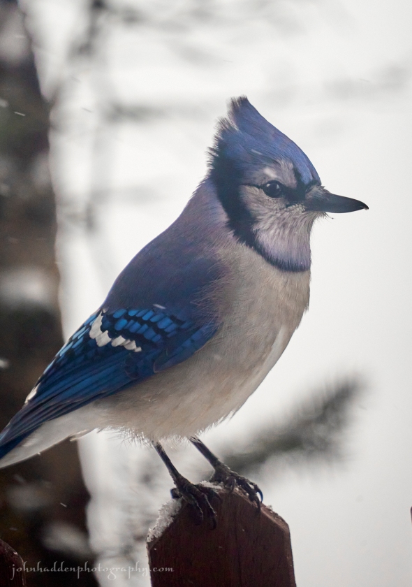 A bluejay poses for its portrait on our front porch
Morning Observation:
This morning in Huntington at 7:50AM it’s currently 32 degrees under cloudy skies. Winds are calm. Relative humidity is 82%, dewpoint 27, barometric pressure 29.71”. We picked up 1.09” of rain/melted precipitation yesterday and have 4” of frozen snow at the stake. Yesterday’s high was 44, and yesterday’s low was 35. The overnight low got down to 32.
This morning in North Hero it’s currently 30 degrees under cloudy skies. Winds are calm. Relative humidity is 79%, dewpoint 24, barometric pressure 29.77”. We picked up 0.24” of rain/melted precipitation yesterday, and are pretty much down to bare ground at the stake with the exception of of a few drifts here and there. Yesterday’s high was 45, and yesterday’s low was 35. The overnight low got down to 29.
There is a High Wind Watch in effect for our region from 10:00PM Friday until 10:00AM Saturday.
Forecast Discussion:
We’ve got mostly quiet and seasonable conditions ahead of us for the next 36 hours or so. A weak trough is expected to skirt to our north today bringing some scattered to numerous snow shower during the afternoon and into the evening. Valley locations will likely only see a dusting with 1″-3″ above 1000′, and perhaps a bit more over favored upslope mountain summits of the northern Greens. A brief ridge of high pressure is expected to build in Friday bringing perhaps a glimpse of sunshine. Then we’re on to our next storm system…
As mentioned yesterday, this system has a lot of the same characteristics as our last storm system. Low pressure will track out of the Mississippi River valley and into the Great Lakes Friday into Saturday, and well to our west on Sunday. We’ll once again be squeezed between a departing ridge of high pressure and the low with resultant high winds along the western slopes of the Greens once again expected. We’ll also be getting another round of mixed precipitation, starting off as a period of snow Friday night, transitioning to rain Saturday, then wrapping up as snow flurries on the back side lingering into Monday. Thankfully models are indicating that winds, while strong, are unlikely to be as strong as our last storm.
Incidentally, I got a report of 82 mph right up the hill at the Camel’s Hump Nordic Ski Center before their anemometer blew apart, and the Mark Breen at the Fairbanks Museum told me this morning that there was a report of 91 mph from Huntington Center. Yikes! Hopefully nothing like that from the upcoming storm, but we will likely see gusting ranging into the 50-60 mph range. So if you’ve got anything else that didn’t get blown away the first time, keep it battened down. Seasonable conditions with a few random snow showers are expected heading into early next week.
3-Day Forecast:
We’ll see cloudy skies today with scattered afternoon snow showers. Highs will be near 34 with west winds 6-9 mph. Chance of precipitation is 50% with snow accumulations of around 1″ possible. Tonight should be cloudy with scattered snow showers, mainly before 11:00PM. Lows will be around 21 with northwest winds 3-5 mph. Chance of precipitation is 50% with new snow accumulation of less than 1″ possible.
Friday should be partly sunny with a 30% chance of snow, mainly after 4:00PM. Highs will be near 32 with light and variable winds. Little or no snow accumulation expected. Friday night should be cloudy with snow before 5:00AM, then snow, possibly mixed with sleet. Lows will be around 26 with southeast winds 8-18 mph increasing to 19-29 mph after midnight. Winds could gust as high as 55 mph. Chance of precipitation is 100% with new snow and sleet accumulation of 1″-3″ possible.
Saturday should be cloudy with rain before 4:00PM, mixing with snow towards sunset. Highs will be near 44 with southeast winds 24-29 mph becoming southwesterly 14-19 mph in the afternoon. Winds could gust as high as 50 mph. Chance of precipitation is 90% with new snow accumulations of less than 0.50″ possible. Saturday night should be mostly cloudy with rain and snow showers likely before 7:00PM, then a chance of snow showers. Lows will be around 21 with southwest winds 17-22 mph gusting to 37 mph. Chance of precipitation is 60%w with rainfall amounts of less than 0.10″ possible.
Almanac:
Last year on this date in Huntington we had a high of 29 and a low of 4. We had 1″ of snow at the stake.
Last year in North Hero we had a high of 27 and a low of 15. We had a dusting of snow at the stake.
Burlington averages for this date are a low of 13 and a high of 29.
The record low was -27 in 1968.
The record high was 59 in 2020 (we had a high of 59 in Huntington).
The Lake Champlain lake level in Burlington is 98.23′.
The water temperature is 39˚.
Last year’s lake level was at 97.15′.
The Mt. Mansfield snow stake depth is 33″.
The average depth for this date is 38″.
Mt. Washington Summit Conditions
Current Temperature: 9
Winds are out of the west at 62 mph gusting to 71 mph
24 hr Precipitation: 2.7″ snow, 0.83″ melted precipitation
Visibility: less than 1/16 mile in freezing fog and blowing snow
Sky Notes:
Sunrise: 7:26AM
Sunset: 4:33PM
Length of day: 9:07:01
Today will be 1:28 longer than yesterday.
The Moon is new, 29 days old with 0% illumination.
Moonrise: 8:05AM
Moonset: 4:34PM
About Today’s Photo:
We’ve got a decent herd of bluejays in attendance at the feeder this season. They seem to come in a pack in the morning and again in the afternoon. This one was patient enough for me to get a nice portrait if him/her!
Sony A7II, Sigma 100-400mm lens @ 400mm, ISO 1250, f/6.3, 1/320″ exposure

Leave a comment