Wednesday, May 31, 2023

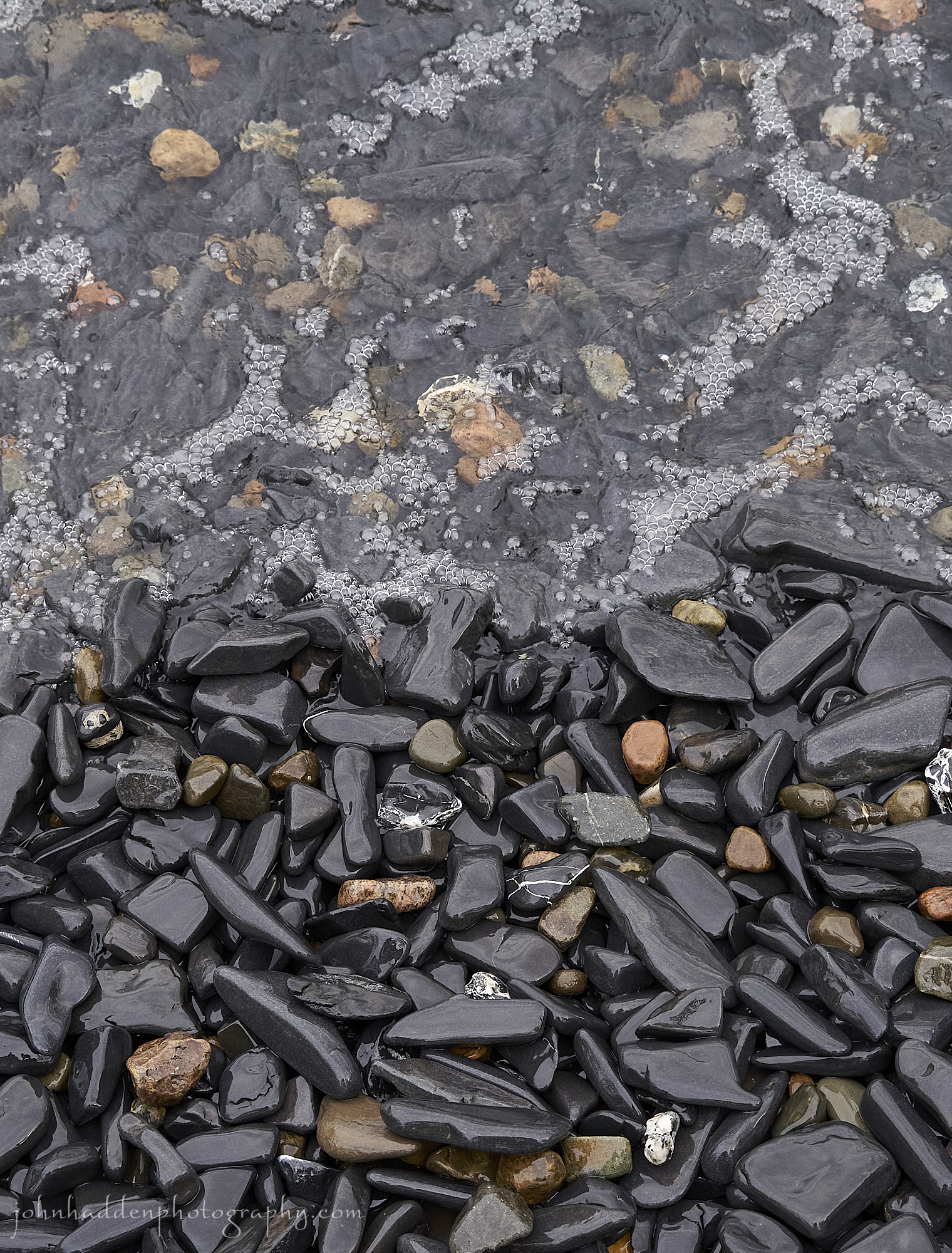
 Tiers of pebbles along the beach tell the story of waves and water levels
Morning Observation:
This morning in North Hero at 7:00AM it’s currently 62 degrees under clear skies. Winds are out of the south at 5-7 mph. Relative humidity is 70%, dewpoint 52, barometric pressure 30.12”. Yesterday’s high was 77, and yesterday’s low was 56. The overnight low got down to 61.
This morning in Huntington it’s currently 55 degrees under clear skies. Winds are calm. Relative humidity is 91%, dewpoint 53, barometric pressure 30.16”. Yesterday’s high was 84, and yesterday’s low was 47. The overnight low got down to 52.
Forecast Discussion:
Another day, another, um, nice, warm, dry, sunny day… High pressure continues its dominance over the region, and we’ll see highs today ranging from the upper 80s to low 90s with low to mid 90s expected for Thursday. We’ll also likely see some smoke from wildfires in Nova Scotia during the day today. The “Rex block” weather pattern that’s been bringing us this extended period of dry and warm weather will finally begin to break down on Friday as low pressure off the Canadian Maritimes retrogrades westward and pushes a backdoor cold front into the region Friday night. We’ll see showers and thunderstorms move into the region from the east Friday afternoon into Friday night bringing some much-needed rainfall. At this point the weekend is looking dry and seasonable with the next chance of showers arriving early next week.
3-Day Forecast:
We’ll see sunny skies today with a high near 89 and southwest winds 5-10 mph. Tonight should be clear with a low around 60 and south winds 5-10 mph.
Thursday should be sunny and hot with a high near 90 and southwest winds 4-6 mph. Thursday night should be mostly clear with a low around 63 and south winds around 6 mph.
Friday should be mostly sunny with a 30 percent chance of showers and thunderstorms after 3:00PM. Highs will be near 85 with northwest winds 5-10 mph. Rainfall amounts between 0.10″-0.25″ are possible with higher amounts possible in thunderstorms. Friday night should be mostly cloudy with a 60% chance of showers and thunderstorms. Lows will be around 57 with north winds 8-10 mph. Rainfall amounts between 0.10″-0.25″ are possible with higher amounts possible in thunderstorms.
Almanac:
Last year on this date in Huntington we had a high of 77 and a low of 59.
Last year in North Hero we had a high of 74 and a low of 59.
Burlington averages for this date are a low of 53 and a high of 74.
The record low was 25 in 1961.
The record high was 91 in 2013 (we had a high of 89 in Huntington).
The Lake Champlain lake level in Burlington is 96.90′.
The water temperature is 58˚.
Last year’s lake level was at 97.49′. The water temperature was at 58˚.
Sky Notes:
Sunrise: 5:11AM
Sunset: 8:28PM
Length of day: 15:16:23
Today will be 1:26 longer than yesterday.
The Moon is waxing gibbous, 11 days old with 83% illumination.
Moonrise: 4:45PM
Moonset: 3:08AM
About Today’s Photo:
The lake level has already dropped 2′ since we move back up to camp on May 10. The tiers of pebbles along our cove beach tell the story of the dropping the water levels and high winds driving waves onto the beach forming long ridges.
iPhone 12 Pro, Halide app
Tuesday, May 30, 2023

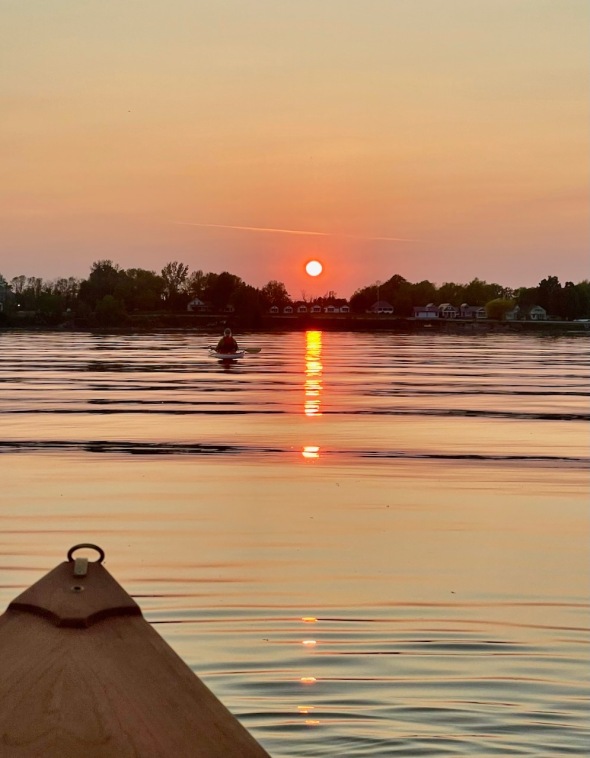 A sunset paddle
Morning Observation:
This morning in North Hero at 6:39AM it’s currently 60 degrees under clear skies. Winds are out of the south at 7-10 mph. Relative humidity is 65%, dewpoint 48, barometric pressure 30.11”. Yesterday’s high was 76, and yesterday’s low was 57. The overnight low got down to 56.
This morning in Huntington it’s currently 48 degrees under clear skies. Winds are calm. Relative humidity is 95%, dewpoint 45, barometric pressure 30.16”. Yesterday’s high was 80, and yesterday’s low was 45. The overnight low got down to 47.
Forecast Discussion:
I’m beginning to feel like a bit of a broken record here, but, once again, high pressure continues to dominate our weather and will continue to do so through Thursday. Highs today will be in the upper 70s to low 80s under clear but smoke-hazy skies and moderate south winds. The warming trend will continue Wednesday with highs in the mid to upper 80s, and top out Thursday in the upper 80s to mid 90. Some record highs are likely to fall on Thursday. Highs will again push toward 90 on Friday before a backdoor cold front move through the region Friday night bringing afternoon showers and thunderstorms. Showers and thunderstorms are expected to continue through Friday night. At this point, the weekend is looking dry and seasonable.
3-Day Forecast:
We’ll see sunny skies today with a high near 82 and south winds around 8 mph in Huntington and 9-17 mph in the Champlain Valley. Tonight should be mostly clear with a low around 55 and south winds 5-7 mph in Huntington and 10-15 mph in the Champlain Valley.
Wednesday should be sunny with a high near 89 and southwest winds 5-9 mph. Wednesday night should be mostly clear with a low around 60 and light south winds.
Thursday should be sunny and hot with a high near 90 and northwest winds 5-7 mph. Thursday night should be mostly clear with a low around 64 and northwest winds around 5 mph becoming southerly after midnight.
Almanac:
Last year on this date in Huntington we had a high of 84 and a low of 50.
Last year in North Hero we had a high of 77 and a low of 58.
Burlington averages for this date are a low of 52 and a high of 73.
The record low was 28 in 1961.
The record high was 92 in 1987.
The Lake Champlain lake level in Burlington is 97.00′.
The water temperature is 54˚.
Last year’s lake level was at 97.53″. The water temperature was at 52˚.
Sky Notes:
Sunrise: 5:12AM
Sunset: 8:27PM
Length of day: 15:14:56
Today will be 1:30 longer than yesterday.
The Moon is waxing gibbous, 9 days old with 74% illumination.
Moonrise: 3:36PM
Moonset: 2:51AM
About Today’s Photo:
With the long days, we’ll often hop in our boats after dinner and head around the point to our south to catch the sun setting over North Hero village. With clear skies and some smoke from Albertan wildfires in the air, the sun has been a big orange ball as it sinks beneath the horizon.
iPhone 12 Pro
Monday, May 29, 2023

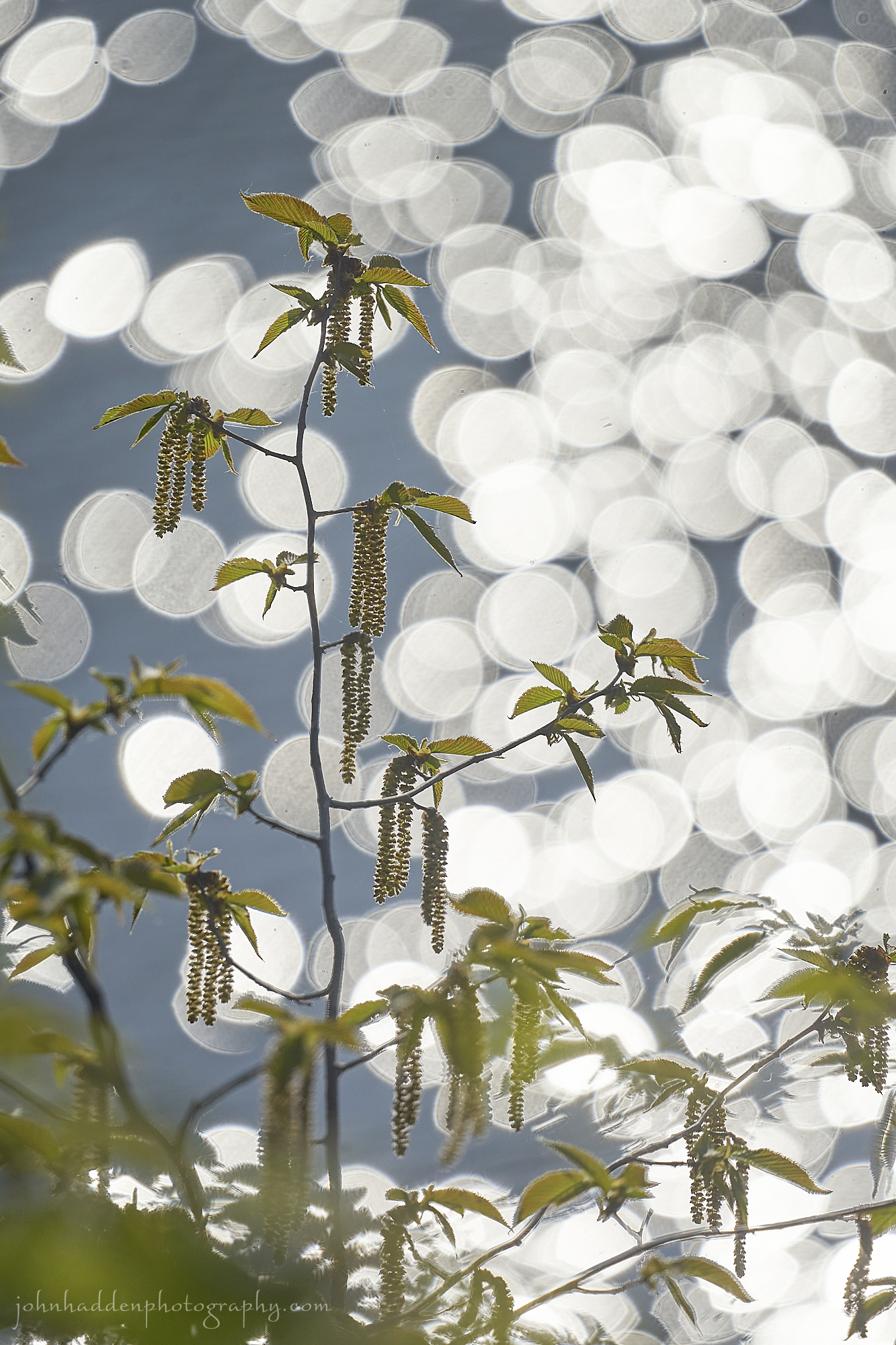
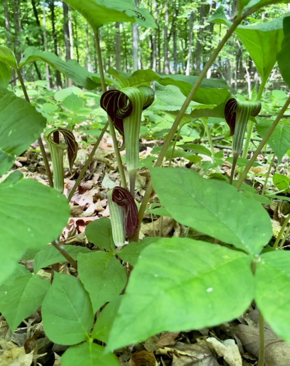 Jack-in-the-pulpits blooming in Pelot’s Natural Area
Morning Observation:
This morning in North Hero at 6:20AM it’s currently 58 degrees under clear skies. Winds are out of the north at 2-4 mph. Relative humidity is 59%, dewpoint 44, barometric pressure 30.05”. Yesterday’s high was 84, and yesterday’s low was 58. The overnight low got down to 57.
This morning in Huntington it’s currently 45 degrees under clear skies. Winds are calm. Relative humidity is 93%, dewpoint 43, barometric pressure 30.04”. Yesterday’s high was 87, and yesterday’s low was 46. The overnight low got down to 45.
Forecast Discussion:
A weak backdoor cold front dropped through the region overnight bringing in slightly cooler air for today. We’ll see highs in the mid 70s to low 80s for most locations under clear skies and light north winds. High pressure will continue to assert itself over there region for the remainder of the week with highs ratcheting up a bit each day and topping out in the upper 80s to low 90s on Thursday. A weak backdoor cold front is expected to drop through the region from the northeast on Friday, but given very dry antecedent air in place, it should only spark a few widely scattered convective showers during the day on Friday. Dry and seasonably warm conditions are expected to return for next weekend.
3-Day Forecast:
We’ll see sunny skies today with a high near 80 in Huntington and 73 in North Hero with northeast winds 7-10 mph. Tonight should be mostly clear with a low around 49 in Huntington and 54 in North Hero with south winds 5-10.
Tuesday should be sunny with a high near 82 and south winds around 8-13 mph. Tuesday night should be mostly clear with a low around 55 and south winds 5-10 mph.
Wednesday should be sunny with a high near 86 and southwest winds 5-10 mph. Wednesday night should be clear with a low around 57 and light and variable winds.
Almanac:
Last year on this date in Huntington we had a high of 79 and a low of 48.
Last year in North Hero we had a high of 70 and a low of 56.
Burlington averages for this date are a low of 52 and a high of 73.
The record low was 34 in 1970.
The record high was 89 in 1978.
The Lake Champlain lake level in Burlington is 97.12′.
The water temperature is 55˚.
Last year’s lake level was at 97.55″. The water temperature was at 51˚.
Sky Notes:
Sunrise: 5:12AM
Sunset: 8:26PM
Length of day: 15:13:26
Today will be 1:33 longer than yesterday.
The Moon is waxing gibbous, 9 days old with 65% illumination.
Moonrise: 2:29PM
Moonset: 2:34AM
About Today’s Photo:
There’s a bumper crop of jack-in-the-pulpits blooming now at Pelot’s Natural Area here on North Hero. The native plants reproduce in an interesting way and are an example of dichogamy, a rare phenomenon in flowering plants. Most plants start out with male flowers, which develop and change over to female flowers as they age, allowing pollinations to occur. Due to this sex-change lifecycle, this species is sometimes called colloquially Jack or Jill-in the-pulpit or Jill-in-the-pulpit.
iPhone 12 Pro
Sunday, May 28, 2023

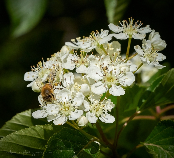 A honey bee works the Korean mountain ash in our front yard
Morning Observation:
This morning in North Hero at 6:30AM it’s currently 60 degrees under clear skies. Winds are out of the south at 2-4 mph. Relative humidity is 74%, dewpoint 51, barometric pressure 30.10”. Yesterday’s high was 72, and yesterday’s low was 53. The overnight low got down to 58.
This morning in Huntington it’s currently 48 degrees under clear skies. Winds are calm. Relative humidity is 96%, dewpoint 45, barometric pressure 30.15”. Yesterday’s high was 81, and yesterday’s low was 39. The overnight low got down to 46.
Forecast Discussion:
High pressure remains in firm control of our weather and will deliver another (and another, and another…) dry, warm, and sunny day today. Highs should be a few degrees above yesterday—in the mid to upper 80s. A weak backdoor cold front will push in from the east tonight cooling things off a tad for Monday with highs “only” in the upper 70s to low 80s. High pressure will continue its rule through the remainder of the week as a “Rex” blocking pattern persists over the continental US. Dry and increasing warm conditions are expected day-to-day with highs on Thursday expected to be in the upper 80s to around 90. The next chance of rain looks possible on Friday as the blocking pattern begins to break down and another backdoor cold front pushes in. There’s not a whole lot of moisture to work with, however, so don’t expect much.
3-Day Forecast:
We’ll see sunny skies today with a high near 87 in Huntington and 80 in North Hero with light south winds becoming westerly in the afternoon. Tonight should be mostly clear with a low around 55 and northwest winds 5-7 mph.
Memorial Day should be sunny with a high near 80 in Huntington and 73 in North Hero with light north winds. Monday night should be mostly clear with a low around 52 south winds 5-19 mph.
Tuesday should be sunny with a high near 81 and southwest winds 5-7 mph in Huntington and 7-15 mph in the Champlain Valley. Tuesday night should be mostly clear with a low around 57 and south winds 3-6 mph.
Almanac:
Last year on this date in Huntington we had a high of 74 and a low of 62. We picked up 0.32″ of rain.
Last year in North Hero we had a high of 67 and a low of 56. We picked up 1.17″ of rain.
Burlington averages for this date are a low of 52 and a high of 73.
The record low was 30 in 1961.
The record high was 92 in 1978.
The Lake Champlain lake level in Burlington is 97.20′.’
The water temperature is 53˚.
Last year’s lake level was at 97.59′. The water temperature was at 52˚.
Sky Notes:
Sunrise: 5:13AM
Sunset: 8:25PM
Length of day: 15:11:52
Today will be 1:37 longer than yesterday.
The Moon is waxing gibbous, 8 days old with 56% illumination.
Moonrise: 1:24PM
Moonset: 2:16AM
About Today’s Photo:
The Korean mountain ash in our front yard in Huntington is in bloom right now, and it’s abuzz with pollinators feasting on the sweet smelling blossoms. This honey bee offered a nice action shot for me as it worked its way over a clump of flowers. The flowers should yield a bumper crop of berries this fall which will feed a variety of birds.
Sony A7II, Sony 90mm macro lens, ISO 800, f/13, 1/2000″ exposure.
Saturday, May 27, 2023

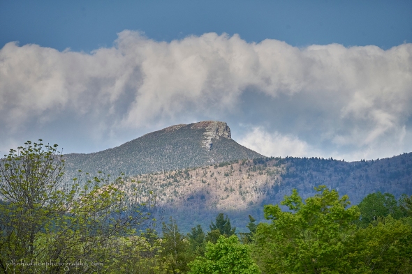
Camel’s Hump in mid spring
Morning Observation:
This morning in North Hero at 6:55AM it’s currently 54 degrees under mostly clear skies. Winds are out of the south at 3-5 mph. Relative humidity is 75%, dewpoint 46, barometric pressure 30.29”. Yesterday’s high was 66, and yesterday’s low was 44. The overnight low got down to 53.
This morning in Huntington it’s currently 42 degrees under clear skies. Winds are calm. Relative humidity is 97%, dewpoint 42, barometric pressure 30.33”. Yesterday’s high was 68, and yesterday’s low was 33. The overnight low got down to 39.
Forecast Discussion:
High pressure? Check. Sunny skies? Check. Seasonably warm temperatures? Check. Light winds? Check. Such is the forecast discussion through the weekend and most of the upcoming week with the caveat that temperatures will be on the increase through the week homing in on 90˚ by Thursday. Enjoy!
3-Day Forecast:
We’ll see sunny skies today with a high near 76 and light southwest winds. Tonight should be mostly clear with a low around 52 and south winds around 5 mph.
Sunday should be sunny with a high near 86 and southwest winds 6-9 mph becoming northwesterly in the afternoon. Sunday night should be mostly clear with a low around 54 and northwest winds 5-10 mph becoming calm in the evening.
Memorial Day should be sunny with a high near 82 and southwest winds around 6 mph. Monday night should be mostly clear with a low around 53 and southeast winds 5-8 mph.
Almanac:
Last year on this date in Huntington we had a high of 78 and a low of 64.
Last year in North Hero we had a high of 71 and a low of 59. We picked up 0.39″ of rain.
Burlington averages for this date are a low of 52 and a high of 72.
The record low was 28 in 1969.
The record high was 95 in 2020 (we had a high of 93 in Huntington).
The Lake Champlain lake level in Burlington is 97.27′.
The water temperature is 49˚.
Last year’s lake level was at 97.56′. The water temperature was at 50˚.
Sky Notes:
Sunrise: 5:14AM
Sunset: 8:24PM
Length of day: 15:10:15
Today will be 1:40 longer than yesterday.
The Moon is in its first quarter, 7 days old wot 47% illumination.
Moonrise: 12:20PM
Moonset: 1:57AM
About Today’s Photo:
I was going to post this photo yesterday since I was in Huntington Thursday night, but Friday morning’s bear took precedent! Nonetheless, the Hump is sporting its mid spring colors with the flanks of Bald Hill in the mid-ground still largely free of leaves. Hiking trails through the region will finally be open this weekend, and it should be a great day to get out into the mountains if that’s where you are!
Sony A7II, Sigma 100-400mm lens @ 255mm, ISO 800, f/8, 1/2500″ exposure.
Friday, May 26, 2023

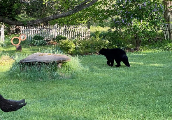
A bear came for a visit this morning!
Morning Observation:
This morning in Huntington at 7:00AM it’s currently 39 degrees under clear skies. Winds are calm. Relative humidity is 97%, dewpoint 38, barometric pressure 30.28”. Yesterday’s high was 60, and yesterday’s low was 37. The overnight low got down to 33.
This morning in North Hero it’s currently 50 degrees under clear skies. Winds are calm. Relative humidity is 68%, dewpoint 41, barometric pressure 30.26”. Yesterday’s high was 63, and yesterday’s low was 43. The overnight low got down to 44.
Forecast Discussion:
Not much to discuss for the forecast. High pressure over the entire eastern two-thirds of the continental US will dominate our weather through the weekend and clear through most of next week. We’ll see a gradual warming trend through the period with highs today in the mid to upper 60s, mid to upper 70s on Saturday, and into the low 80s by Sunday. Temperatures will continue their upward climb through next week with highs expected to reach the upper 80s to near 90 by Thursday. Enjoy!
3-Day Forecast:
We’ll see sunny skies today with a high near 68 and northwest winds 5-10 mph. Tonight should be mostly clear with a low around 46 and north winds around 5 mph becoming calm in the evening.
Saturday should be sunny with a high near 79 and southwest winds 5-7 mph. Saturday night should be clear with a low around 53 and south winds 3-7 mph.
Sunday should be sunny with a high near 82 and south winds 6-8 mph becoming westerly 5-7 mph in the afternoon. Sunday night should be mostly clear with a low around 55 and northwest winds 5-7 mph.
Almanac:
Last year on this date in Huntington we had a high of 77 and a low of 52.
Last year in North Hero we had a high of 67 and a low of 59.
Burlington averages for this date are a low of 51 and a high of 72.
The record low was 32 in 1969.
The record high was 92 in 2020 (we had a high of 92 in Huntington).
The Lake Champlain lake level in Burlington is 97.37′.
The water temperature is 47˚.
Last year’s lake level was at 97.71″. The water temperature was at 49˚.
Sky Notes:
Sunrise: 5:15AM
Sunset: 8:23PM
Length of day: 15:08:34
Today will be 1:43 longer than yesterday.
The Moon is a waxing crescent, 6.2 days old with 37% illumination.
Moonrise: 11:15AM
Moonset: 1:33AM
About Today’s Photo:
I was heading out my front door here in Huntington this morning (like 5 minutes ago…) to get my camera out of my car, and, upon opening the door, I discovered this bear walking across my front porch! We were both quite surprised, but, while I ran back in to the house to grab my phone, the bear took its time ambling across the yard, though one of our gardens, and off into the pines by the edge of the field. Quite the morning encounter!
iPhone 12 Pro
Thursday, May 25, 2023

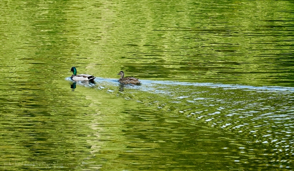
A pair of mallard in our cove
Morning Observation:
This morning in North Hero at 7:05AM it’s currently 47 degrees under clear skies. Winds are out of the north at 3-5 mph. Relative humidity is 81%, dewpoint 42, barometric pressure 30.18”. We picked up 0.36” of rain yesterday. Yesterday’s high was 62, and yesterday’s low was 44. The overnight low got down to 43.
This morning in Huntington it’s currently 43 degrees under partly cloudy skies. Winds are calm. Relative humidity is 88%, dewpoint 40, barometric pressure 30.18”. We picked up 0.25” of rain yesterday. Yesterday’s high was 66, and yesterday’s low was 42. The overnight low got down to 42.
Forecast Discussion:
High pressure building into the region will dominate our weather clear through the weekend and into at least the middle of next week bringing dry and increasingly warm conditions. Highs today will be on the cool side—upper 50s to low 60s—with moderate north winds. There is a Frost Advisory in effect for tonight for most of the region outside of the Champlain Valley with lows expected to drop into the low 30s overnight. A warming trend will kick off on Friday with highs in the upper 60s Friday, mid 70s Saturday, and low 80s by Sunday, all under clear skies with light winds. Temperatures will continue their upward trajectory with highs expected to approach 90 by Wednesday.
3-Day Forecast:
We’ll see mostly sunny skies today with a high near 62 and north winds 7-13 mph. Tonight should be mostly clear with lows around 35 with north winds around 6 mph becoming calm in the evening.
Friday should be sunny with patchy morning frost. Highs will be near 67 with northwest winds 6-10 mph. Friday night should be mostly clear with a low around 44 and calm winds becoming southerly around 5 mph.
Saturday should be sunny with a high near 76 and west winds 3-5 mph. Saturday night should be mostly clear with a low around 51 and calm winds.
Almanac:
Last year on this date in Huntington we had a high of 75 and a low of 41.
Last year in North Hero we had a high of 69 and a low of 49.
Burlington averages for this date are a low of 51 and a high of 72.
The record low was 28 in 1958.
The record high was 91 in 2010 (we had a high of 88 in Huntington).
The Lake Champlain lake level in Burlington is 97.48′.
The water temperature is 51˚.
Last year’s lake level was at 97.79″. The water temperature was at 48˚.
Sky Notes:
Sunrise: 5:15AM
Sunset: 8:22PM
Length of day: 15:06:51
Today will be 1:46 longer than yesterday.
The Moon is a waxing crescent, 5.3 days old with 28% illumination.
Moonrise: 10:10AM
Moonset: 1:09AM
About Today’s Photo:
A pair of mallards have been frequenting our cove over the past couple of days (keeping company with Canada goose family). I love the way the green of the trees reflects in the water and the overlapping ripples of the ducks’ wake.
Sony A7II, Sigma 100-400mm lens @ 400mm, ISO 800, f/8, 1/800″ exposure
Wednesday, May 24, 2023

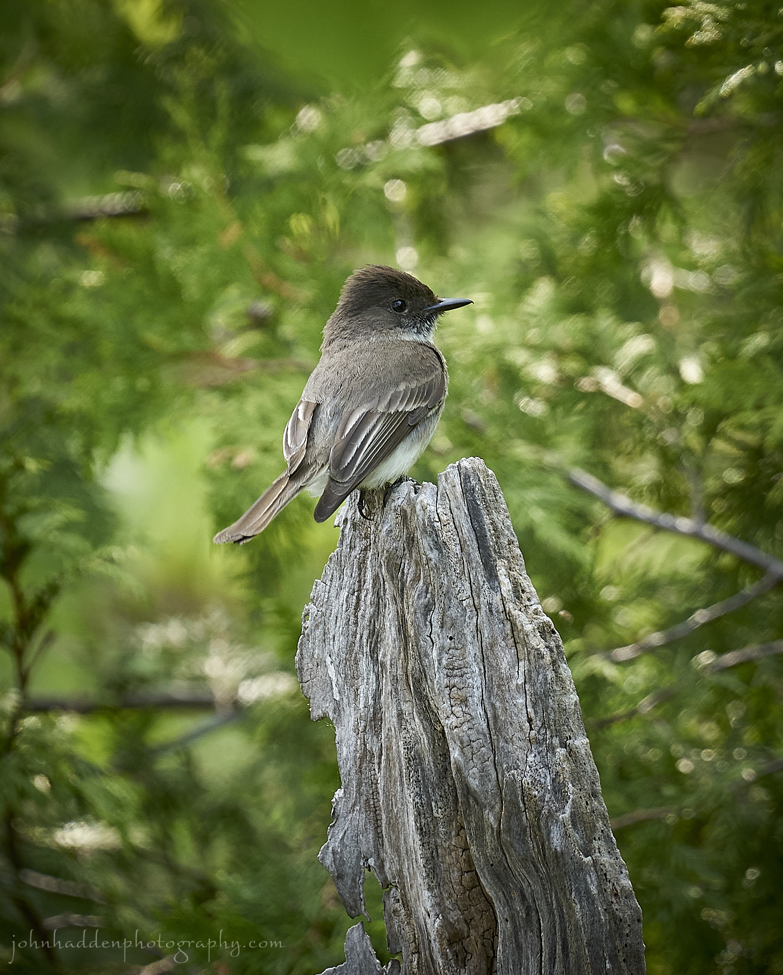
An eastern phoebe poses outside our porch windows
Morning Observation:
This morning in North Hero at 6:45AM it’s currently 57 degrees under overcast skies. Winds are out of the south at 5-7 mph. Relative humidity is 80%, dewpoint 51, barometric pressure 29.97”. Yesterday’s high was 73, and yesterday’s low was 43. The overnight low got down to 57.
This morning in Huntington it’s currently 56 degrees under overcast skies. Winds are calm. Relative humidity is 90%, dewpoint 53, barometric pressure 30.00”. Yesterday’s high was 77, and yesterday’s low was 36. The overnight low got down to 52.
Forecast Discussion:
Morning radar imagery shows an area of low pressure over Newfoundland with a clearly defined strong cold front stretched back southwestward and poised along the St. Lawrence River. Showers are aligned along this frontal boundary and are expected to drop southeastward into Vermont during the day today bringing widespread precipitation to the region along with the possibility of a few rumbles of thunder. Much cooler air will move in behind the front this afternoon shifting winds into the northwest and dropping temperatures from highs in the 60s by midday into the upper 40s and low 50s by this evening. Another cool night is in store for us tonight with highs in the upper 30s and low 40s under clearing skies as high pressure begins to build in. Thursday’s looking mostly sunny but cool with highs only around 60 with breezy north winds. High pressure will dominate the remainder of the forecast with a gradual increase in temperatures expected as we head towards the Memorial Day weekend. Highs on Saturday should be near 70 and close to 80 by Sunday.
3-Day Forecast:
We’ll see cloudy skies today with showers, mainly this afternoon. Temperature will top our near 64 this morning, then fall to around 48 during the remainder of the day. Winds will be out of the south at 7-11 mph, then become northerly in the afternoon. Chance of precipitation is 100% with rainfall amounts between 0.10″-0.25″ possible. Tonight should be partly cloudy with a 30% chance of showers, mainly before 7:00PM. Lows will be around 40 with north winds around 9 mph in Huntington and 13-21 mph in the Champlain Valley.
Thursday should be mostly sunny with a high near 59 and north winds 8-11 mph in Huntington and 14-17 mph in the Champlain Valley. Thursday night should be mostly clear with a low around 39 and north winds around 6 mph becoming calm in the evening.
Friday should be sunny with a high near 66 and northwest winds 5-9 mph. Friday night should be mostly clear with a low around 47 and light and variable winds.
Almanac:
Last year on this date in Huntington we had a high of 68 and a low of 35.
Last year in North Hero we had a high of 66 and a low of 47.
Burlington averages for this date are a low of 51 and a high of 72.
The record low was 28 in 1963.
The record high was 88 in 2007 (we had a high of 88 in Huntington).
The Lake Champlain lake level in Burlington is 97.47′.
The water temperature is 54˚.
Last year’s lake level was at 97.85″. The water temperature was at 46˚.
Sky Notes:
Sunrise: 5:16AM
Sunset: 8:21PM
Length of day: 15:05:04
Today will be 1:49 longer than yesterday.
The Moon is a waxing crescent, 4.4 days old with 20% illumination.
Moonrise: 9:05AM
Moonset: 12:35AM
About Today’s Photo:
Eastern phoebes are one of earlier species to return in the spring. Their eponymous “fee-ee-bee” call is distinct, and they spend their days hunting insects in woodlands and near rivers and lakes where insects are plentiful. This little guy was perched on a rotting maple stump right outside our porch windows, and seemed happy to pose for me.
Sony A7II, Sigma 100-400mm lens @ 400mm, ISO 800, f/8, 1/200″ exposure.
Tuesday, May 23, 2023


Silver maple seeds on the shore
Morning Observation:
This morning in North Hero at 6:20AM it’s currently 44 degrees under clear skies. Winds are calm. Relative humidity is 95%, dewpoint 43, barometric pressure 30.28”. Yesterday’s high was 59, and yesterday’s low was 44. The overnight low got down to 43.
This morning in Huntington it’s currently 39 degrees under clear skies. Winds are calm. Relative humidity is 97%, dewpoint 38, barometric pressure 30.30”. Yesterday’s high was 68, and yesterday’s low was 38. The overnight low got down to 36.
Forecast Discussion:
After a chilly start to the day, we’ve got another nice spring day on tap with highs bumping into the low to mid 70s under mostly clear skies and an increasing southerly airflow. A weak upper level shortwave will cross the region during the day bringing some widely scattered convective showers over higher terrain, otherwise most of us should see dry conditions. After a mild and breezy night tonight, low pressure tracking through James Bay later tonight will drag a strong cold front across the region on Wednesday bringing widespread rains to the region Wednesday. Temperatures will top out early in the day—in the mid 60s north and west and low 70s south and east—before front swings through. A few thunderstorms are possible with the frontal passage. Once again, much cooler air will move in behind the departing front dropping temperatures sharply into the low 50s and upper 40s by the evening with brisk north winds. After a cool night Wednesday night, highs on Thursday are only expected to reach the upper 50s and low 60s under mostly sunny skies as high pressure builds back in. Temperatures will moderate back to more seasonal levels as we head into the upcoming weekend with dry conditions expected.
3-Day Forecast:
We’ll see sunny skies today with a high near 75 and south winds 5-8 mph. Tonight should be mostly clear with a low around 54 and south winds 8-11 mph in Huntington and 14-20 mph in the Champlain Valley.
Wednesday should be cloudy with showers and possibly a thunderstorm in the afternoon. Highs will be near 72 in Huntington and 62 in North Hero with south winds 10-15 mph in Huntington and 20-25 mph in the Champlain Valley, becoming northerly in the afternoon. Chance of precipitation is 90% with rainfall amounts between 0.25″-0.50″ possible. Wednesday night should be mostly cloudy with showers likely, mainly before 7:00PM. Lows will be around 40 with north winds 10-20 mph. Chance of precipitation is 60% with rainfall amounts between 0.10″-0.25″ possible.
Thursday should be mostly sunny with a high near 58 and north winds 8-11 mph. Thursday night should be mostly clear with a low around 40 and north winds around 6 mph becoming calm in the evening.
Almanac:
Last year on this date in Huntington we had a high of 62 and a low of 42.
Last year in North Hero we had a high of 61 and a low of 47.
Burlington averages for this date are a low of 50 and a high of 71.
The record low was 31 in 1967.
The record high was 91 in 1992.
The Lake Champlain lake level in Burlington is 97.64′.
The water temperature is 48˚.
Last year’s lake level was at 97.92′. The water temperature was at 52˚.
Sky Notes:
Sunrise: 5:17AM
Sunset: 8:20PM
Length of day: 15:03:14
Today will be 1:52 longer than yesterday.
The Moon is a waxing crescent, 3.4 days old with 13% illumination.
Moonrise: 8:02AM
No Moonset
About Today’s Photo:
The dark grey of the slate beach pebbles make a nice backdrop to these two sets of silver maple “helicopter” seed pairs. After breezy south winds drive waves ashore, it’s always interesting to see what washes up!
Sony A7II, Sony 24-240mm lens @ 106mm, ISO 1600, f/7.1, 1/500″ exposure.
Monday, May 22, 2023

Slate pebbles and frothy water on our beach
Morning Observation:
This morning in North Hero at 6:30AM it’s currently 46 degrees under clear skies. Winds are out of the north at 4-7 mph. Relative humidity is 70%, dewpoint 37, barometric pressure 30.23”. We picked up 0.11” of rain yesterday. Yesterday’s high was 64, and yesterday’s low was 52. The overnight low got down to 44.
This morning in Huntington it’s currently 41 degrees under clear skies. Winds are calm. Relative humidity is 95%, dewpoint 40, barometric pressure 30.21”. We picked up 0.21” of rain yesterday. Yesterday’s high was 70, and yesterday’s low was 49. The overnight low got down to 41.
Forecast Discussion:
The passage of cold front overnight has brought in dry and cool air under a broad area of high pressure. Highs today will range from the low to mid 60s to perhaps a few 70s in the lower Connecticut River valley later this afternoon under clear skies and light north winds. Tonight should be another chilly night with lows in the mid 40s. The high will shift offshore Tuesday turning winds into the south and bringing in warmer air with highs in the mid to upper 70s under clear skies. Low pressure tracking through James Bay on Wednesday will drag a sharp cold front through their region in Wednesday bringing widespread rainfall during the day Wednesday. Highs should top out in the upper 60s early in the day and drop behind the frontal passage. A chilly night is expected Wednesday night with highs only in the upper 30s and low 40s with some possible snowfall over mountain summits. Forecast models are in a bit of a disagreement regarding the evolution of the aforementioned low with some models calling for a quick passage into the Canadian Maritimes Friday while others see it stalling and pinwheeling over the northeast Thursday into Friday. Regardless, Thursday is looking showery, but, depending on which models win out, we may see a dry weekend or a potentially showery one. Stay tuned…
3-Day Forecast:
We’ll see sunny skies today with a high near 64 and northwest winds 5-9 mph. Tonight should be mostly clear and cool with a low around 44 and calm winds.
Tuesday should be sunny with a high near 77 and south winds 6-9 mph. Tuesday night should be mostly clear and mild with a low around 52 and south winds 8-10 mph in Huntington and 17-22 mph in the Champlain Valley.
Wednesday should be cloudy with showers. Highs will be near 69 with south winds around 12-18 mph becoming westerly in the afternoon. Chance of precipitation is 80% with rainfall amounts between 0.50”-0.75” possible. Wednesday night should be mostly cloudy with showers likely, mainly before 8:00PM. Lows will be around 40 with north winds around 8 mph. Chance of precipitation is 60% with rainfall amounts between 0.25″-0.50″ possible.
Almanac:
Last year on this date in Huntington we had a high of 86 and a low of 54. We picked up 0.01″ of rain.
Last year in North Hero we had a high of 80 and a low of 54. We picked up 0.36″ of rain.
Burlington averages for this date are a low of 50 and a high of 71.
The record low was 34 in 2002 (We had a low of 34 in Huntington).
The record high was 93 in 1977.
The Lake Champlain lake level in Burlington is 97.74′.
The water temperature is 50˚.
Last year’s lake level was at 97.94″. The water temperature was at 54˚.
The Mt. Mansfield snow stake depth is 1″!
The average depth for this date is 12″.
(Methinks we shall be retiring this observation for the summer…)
Sky Notes:
Sunrise: 5:18AM
Sunset: 8:19PM
Length of day: 15:01:21
Today will be 1:55 longer than yesterday.
The Moon is a waxing crescent, 2.5 days old with 7% illumination.
Moonrise: 7:06AM
Moonset: 11:53PM
About Today’s Photo:
I’m forever intrigued by the shape, texture, and colors of the pebbles on our beach. You’ll find a wide range of shapes of mostly slated, but there are often a few bits of granitic stone tossed in as well.
Sony A7II, Sony 24-240mm lens @ 46mm, ISO 1600, f/8, 1/640″ exposure.
Sunday, May 21, 2023

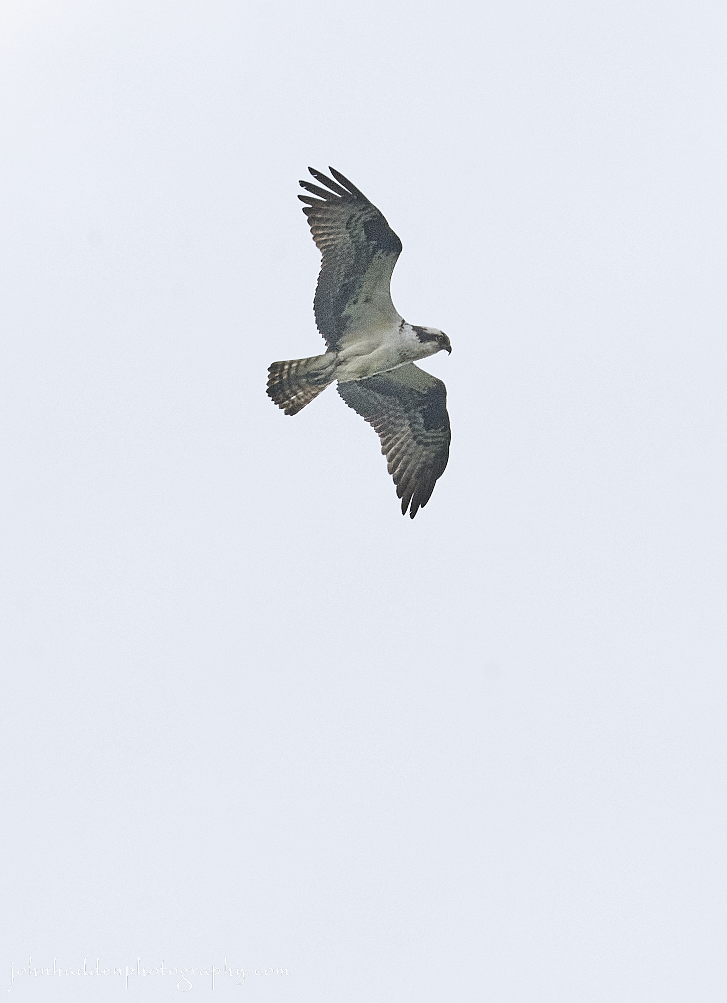
An osprey wheeling above our cove
Morning Observation:
This morning in North Hero at 6:40AM it’s currently 53 degrees under partly cloudy skies. Winds are out of the south at 6-8 mph. Relative humidity is 82%, dewpoint 47, barometric pressure 29.78”. We picked up 0.37” of rain yesterday and 0.03” so far today. Yesterday’s high was 67, and yesterday’s low was 53. The overnight low got down to 52.
This morning in Huntington it’s currently 49 degrees under partly cloudy skies. Winds are calm. Relative humidity is 95%, dewpoint 47, barometric pressure 29.81”. We picked up 0.24” of rain yesterday and 0.19” so far today. Yesterday’s high was 74, and yesterday’s low was 55. The overnight low got down to 47.
Forecast Discussion:
Morning radar imagery shows the two low pressure systems that brought our overnight rains—a northerly low and coastal low—now moving to our north and off shore to our east respectively. While we should anticipate a mostly dry and seasonable day today, a few showers are not out of the questions over higher elevations of the northern Greens and ‘Dacks this afternoon as a cold front swings through the region. Skies should be quite hazy today due to smoke from Alberta wildfires, and some of this smoke may even mix down to ground level keeping a lid on temperatures. Cooler and drier air will move in behind the aforementioned cold front tonight with lows expected to drop into the 30s and 40s overnight under clear skies. Some isolated frost is possible in the usual cold pockets. High pressure will be in charge for the first part of the upcoming week with dry and cool conditions expected Monday and Monday night and more seasonal conditions Tuesday. The next chance for rain arrives Wednesday as an elongated trough is expected to move through the region.
3-Day Forecast:
We’ll see mostly sunny skies today with isolated showers possible this afternoon. Highs will be near 68 with southwest winds 5-10 mph becoming northwesterly in the afternoon. Chance of precipitation is 20%. Tonight should be partly cloudy with isolated showers before 10:00PM. Lows will be around 42 with northwest winds 5-9 mph becoming calm after midnight. Chance of precipitation is 20%.
Monday should be sunny with a high near 67 and north winds 3-6 mph. Monday night should be mostly clear with a low around 42 and light and variable winds.
Tuesday should be sunny with a high near 76 and southwest winds 5-8 mph. Tuesday night should be mostly clear with a low around 50 and south winds 6-8 mph.
Almanac:
Last year on this date in Huntington we had a high of 90 and a low of 68. We picked up 0.04″ of rain.
Last year in North Hero we had a high of 80.
Burlington averages for this date are a low of 29 in 1964.
The record high was 91 in 1977.
The Lake Champlain lake level in Burlington is 97.80′.
The water temperature is 49˚.
The Mt. Mansfield snow stake depth is 3″.
The average depth for this date is 15″.
Sky Notes:
Sunrise: 5:19AM
Sunset: 8:18PM
Length of day: 14:59:25
Today will be 1:58 longer than yesterday.
The Moon is a waxing crescent, 1.6 days old with 3% illumination.
Moonrise: 6:17AM
Moonset: 11:00PM
About Today’s Photo:
Ospreys are a common sight here on North Hero. It seems their schedule leans towards afternoon flights over our cove here on the point, and I’ll often hear their keening cry alerting me to their presence. I’ve watched as one will dive into the waters of our cove catching a fish below the surface. Of course having my camera at the ready for such an occurrence is usually unlikely…
Sony A7II, Sigma 100-400mm lens @ 400mm, ISO 800, f/13, 1/1000″ exposure.
Saturday, May 20, 2023

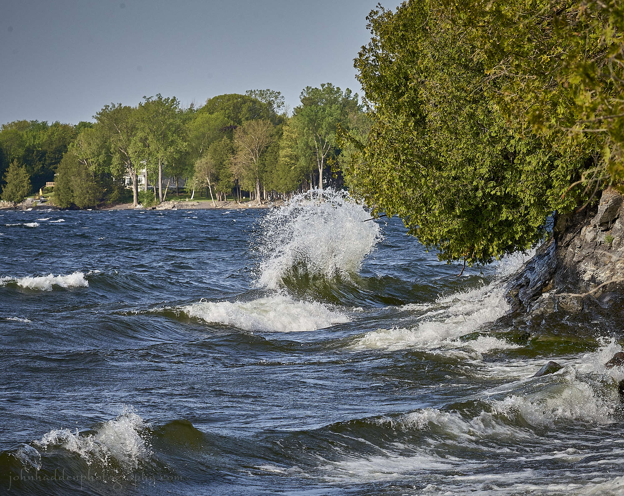
Strong south winds create tall wave stacks along the shore
Morning Observation:
This morning in North Hero at 6:50AM it’s currently 55 degrees under overcast skies. Winds are out of the south at 8-10 mph. Relative humidity is 80%, dewpoint 49, barometric pressure 30.04”. We picked up 0.03” of rain so far today. Yesterday’s high was 66, and yesterday’s low was 48. The overnight low got down to 53.
This morning in Huntington it’s currently 58 degrees under overcast skies. Winds are calm. Relative humidity is 76%, dewpoint 50, barometric pressure 30.08”. We picked up 0.03” of rain so far today. Yesterday’s high was 73, and yesterday’s low was 39. The overnight low got down to 55.
Forecast Discussion:
Morning radar imagery shows a center of low pressure just west of Lake Erie and a second coastal low just off the coast of Virginia. Rain will be moving into the region from both of these lows, however, as the coastal low tracks northward into New England later today, it will help to slow the approach of the western low setting up a well-defined dry slot over portions of the North Country for much of the day. Western and southern sections are more likely to see rain during the day today while northern sections may be mostly dry with even a break of sunshine tossed in. The two lows are expected to merge over the region later this evening/tonight bringing more widespread rain overnight. Highs today should range from the mid 60s to low 70s. High pressure will build back later Sunday bringing partly too mostly sunny with highs in the low to mid 70s. Another extended period of dry and seasonable conditions is expected through most the upcoming week with the chance of some showers on Wednesday.
3-Day Forecast:
We’ll see mostly cloudy skies today with a 20% chance of showers this morning and again this afternoon. Highs will be near 70 with south winds 10-15 mph. Tonight should be cloudy with showers. Lows will be around 51 with south winds 5-10 mph becoming westerly after midnight. Chance of precipitation is 90% with rainfall amounts between 0.25″-0.50″ possible.
Sunday should be mostly sunny with a high near 71 and southwest winds 9-13 mph becoming northwesterly in the afternoon. Sunday night should be partly cloudy and cool with a low around 42 and northwest winds 5-7 mph.
Monday should be sunny with a high near 63 and north winds 5-10 mph. Monday night should be clear and chilly with a low around 40 and north winds around 5 mph becoming calm in the evening.
Almanac:
Last year on this date in Huntington we had a high of 82 and a low of 43. We picked up 0.10″ of rain.
Last year in North Hero we had a high of 69 and a low of 49.
Burlington averages for this date are a low of 49 and a high of 71.
The record low was 30 in 2002 (We had a low of 27 in Huntington).
The record high was 92 in 2021 (we had a high of 90 in Huntington).
The Lake Champlain lake level in Burlington is 97.84′.
The water temperature is 49˚.
Last year’s lake level was at 98.99′. The water temperature was at 54˚.
The Mt. Mansfield snow stake depth is 6″.
The average depth for this date is 16″.
Sky Notes:
Sunrise: 5:20AM
Sunset: 8:17PM
Length of day: 14:57:26
Today will be 2:01 longer than yesterday.
The Moon is a waxing crescent, 1 day old with 1% illumination.
Moonrise: 5:37AM
Moonset: 9:57PM
About Today’s Photo:
Yesterday’s strong south winds made for a rowdy day out on the water with 3″-4″ waves crashing into the shoreline below our camp. Along a steeper section of shoreline to the west, tall wave stacks developed where the energy from incoming waves met the energy of retreating water.
Sony A7II, Sigma 100-400mm lens @ 164mm, ISO 1600, f/14, 1/640″ exposure.
Friday, May 19, 2023

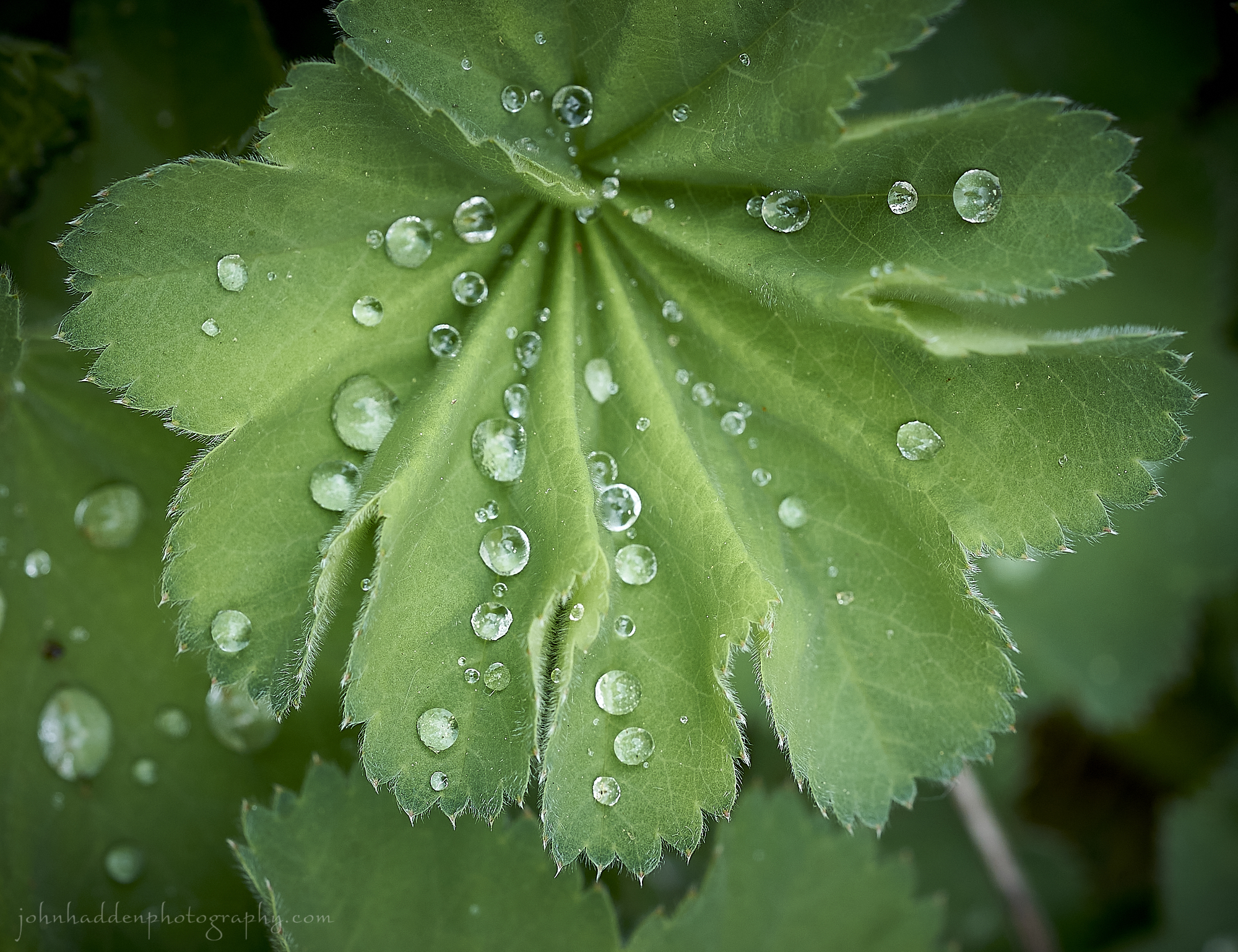
Raindrop bead on ladies mantle leaves
Morning Observation:
This morning in North Hero at 6:15AM it’s currently a blustery 51 degrees under hazy clear skies. Winds are out of the south at 10-12 mph. Relative humidity is 74%, dewpoint 43, barometric pressure 30.16”. Yesterday’s high was 57, and yesterday’s low was 36. The overnight low got down to 48.
This morning in Huntington it’s currently 52 degrees under clear skies. Winds are calm. Relative humidity is 67%, dewpoint 41, barometric pressure 30.23”. Yesterday’s high was 64, and yesterday’s low was 25. The overnight low got down to 39.
There is a Lake Wind Advisory in effect.
Forecast Discussion:
Morning radar imagery shows a low pressure system currently over Lake Superior. After a breezy and seasonably mild day today, this low is expected to move eastward towards New England tonight while a secondary coastal low develops and moves up the New England coast. These two features are expected to track directly over New England Saturday bringing widespread showers to the region starting Saturday morning and continuing into Sunday. A break in the showers is expected Saturday evening as a dry slot slides through, with some lingering scattered showers expected into Sunday morning. Dry and seasonably mild conditions return by Monday with another stretch of dry and seasonable conditions expected for most of next week.
3-Day Forecast:
We’ll see mostly sunny, wildfire-smoke-hazed skies today with a high near 73 and south winds 10-16 mph in Huntington and 18-23 mph in the Champlain Valley. Tonight should bring increasing clouds and a 20% chance of showers. Lows will be around 54 and south winds 14-16 mph in Huntington and 22-24 mph in the Champlain Valley.
Saturday should be mostly cloudy with showers likely, mainly in the afternoon. Highs will be near 69 with south winds 11-14 mph in Huntington and 17-22 mph in the Champlain Valley. Chance of precipitation is 60% with rainfall amounts between 0.10″-0.25″ possible. Saturday night should be cloudy with showers. Lows will be around 51 with southwest winds around 8-13 mph. Chance of precipitation is 80% with rainfall amounts between 0.25″-0.50″ possible.
Sunday should start our mostly cloudy, then become partly sunny with a high near 70 and northwest winds 9-13 mph. Sunday night should be partly cloudy with a low around 40 and north winds 6-9 mph.
Almanac:
Last year on this date in Huntington we had a high of 55 and a low of 37. We picked up 0.09″ of rain.
Last year in North Hero we had a high of 55 and a low of 47. We picked up 0.53″ of rain.
Burlington averages for this date are a low of 49 and a high of 70.
The record low was 31 in 1987.
The record high was 91 in 1989.
The Lake Champlain lake level in Burlington is 98.02′.
The water temperature is 49˚
Last year’s lake level was at 97.90″. The water temperature was at 55˚.
The Mt. Mansfield snow stake depth is 10″.
The average depth for this date is 18″.
Sky Notes:
Sunrise: 5:21AM
Sunset: 8:16PM
Length of day: 14:55:25
Today will be 2:04 longer than yesterday.
The Moon is new, 29 days old with 0% illumination.
Moonrise: 5:05AM
Moonset: 8:47PM
About Today’s Photo:
If you look closely at the photo, you’ll see the tiny hairs on the surface of this lady’s mantle leaf that allow water to bead up in large round drops.
Sony A7II, Sony 90mm macro lens, ISO 800, f/14, 1/125″ exposure.
Thursday, May 18, 2023

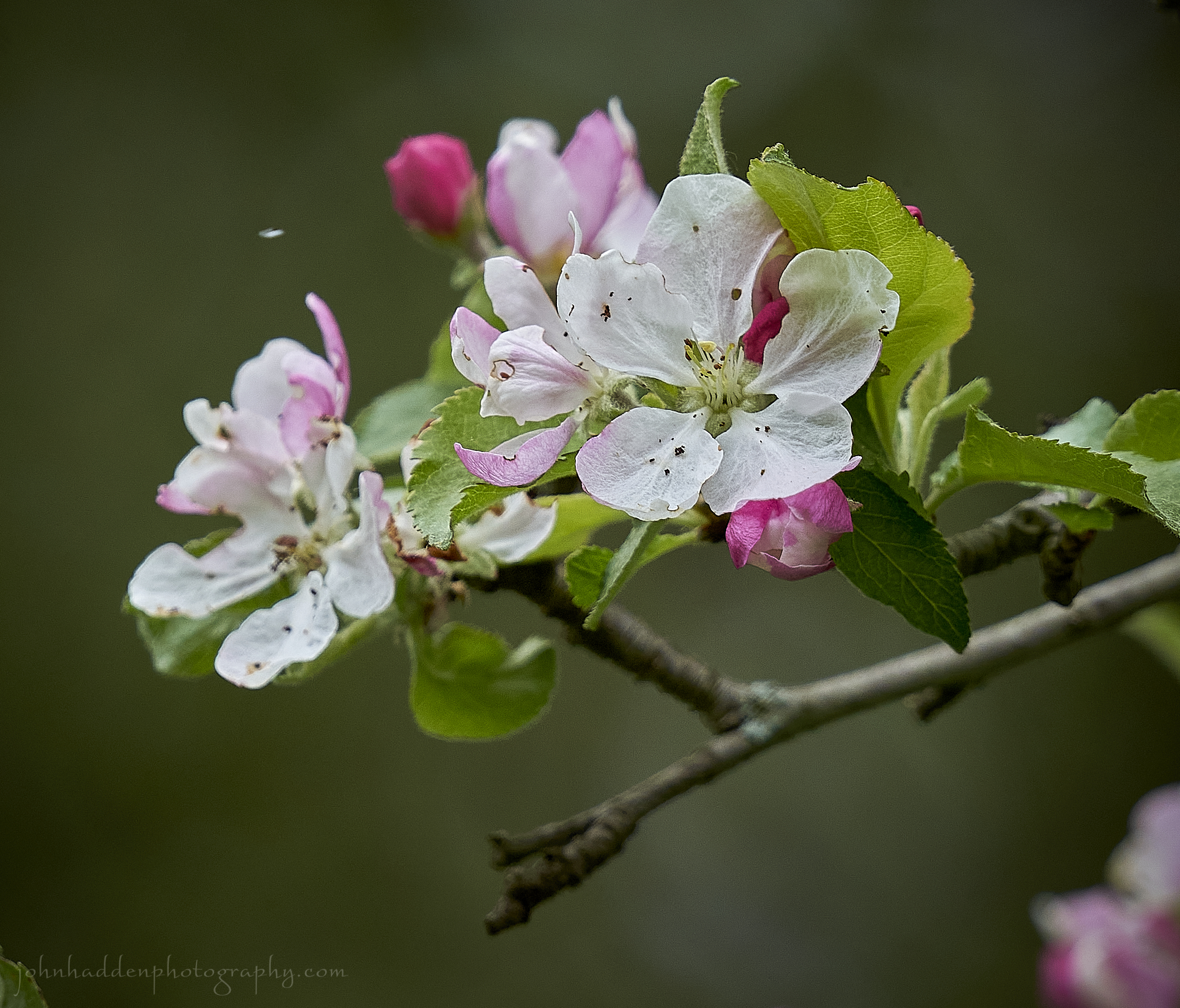
Apple blossoms and a snowflake in Huntington
Morning Observation:
This morning in North Hero at 6:40AM it’s currently 41 degrees under clear skies. Winds are out of the south at 2-4 mph. Relative humidity is 65%, dewpoint 30, barometric pressure 30.21”. Yesterday’s high was 48, and yesterday’s low was 38. The overnight low got down to 36.
This morning in Huntington it’s currently a frosty 26 degrees under clear skies. Winds are calm. Relative humidity is 93%, dewpoint 24, barometric pressure 30.23”. Yesterday’s high was 45, and yesterday’s low was 27. The overnight low got down to 25.
Forecast Discussion:
After a record-settingly cold start to the morning, temperatures will quickly rebound to near seasonal levels today under building high pressure and a southerly airflow. Highs today should top out in the low to mid 60s under clear skies. An increasing southerly airflow will allow temperatures to jump into the low 70s on Friday with gusty south winds expected. A Lake Wind Advisory will be likely for the waters of Lake Champlain tomorrow. Low pressure approaching from the Great Lakes Friday night will swing a cold front through the region Friday night bringing our next chance of rain late Friday night, through much of Saturday, and lingering into Sunday morning as the low passes to our north dragging another cold front though the region Sunday. Cooler and drier air will move in behind the front bringing another day of below seasonal temperatures Monday. A trend towards warmer drier conditions is expected for the remainder of the week.
3-Day Forecast:
We’ll see sunny skies today with a high near 61 and south winds 5-7 mph. Tonight should be mostly clear with a low around 44 and south winds 5-8 mph in Huntington and 8-17 mph in the Champlain Valley.
Friday should be sunny with a high near 70 and south winds around 14 mph in Huntington and 23-25 mph in the Champlain Valley. Friday night should bring increasing clouds with a 30% chance of showers late. Lows will be around 51 with south winds 11-13 mph in Huntington and 23-25 mph in the Champlain Valley.
Saturday should be mostly cloudy with showers likely, mainly after 2:00pm. Highs will be near 68 with south winds 9-16 mph. Chance of precipitation is 60% with rainfall amounts between 0.10″-0.25″ possible. Saturday night should be cloudy with showers. Lows will be around 52 with southeast winds 8-10 mph. Chance of precipitation is 80% with rainfall amounts between 0.25″-0.50″ possible.
Almanac:
Last year on this date in Huntington we had a high of 64 and a low of 38. We picked up 0.18″ of rain.
Last year in North Hero we had a high of 63 and a low of 45.
Burlington averages for this date are a low of 49 and a high of 70.
The record low was 29 in 1983.
The record high was 93 in 2017 (we had a high of 92 in Huntington).
The Lake Champlain lake level in Burlington is 98.11′.
The water temperature is 42˚.
Last year’s lake level was at 97.86″.
The water temperature was at 56˚.
The Mt. Mansfield snow stake depth is 10″.
The average depth for this date is 19″.
Sky Notes:
Sunrise: 5:22AM
Sunset: 8:15PM
Length of day: 14:53:21
Today will be 2:06 longer than yesterday.
The Moon is a waning crescent, 28 days old with 2% illumination.
Moonrise: 4:39AM
Moonset: 7:33PM
About Today’s Photo:
I took this shot of apple blossoms in our back yard in Huntington yesterday morning. I was trying to capture some of the falling snow in the shot, but only managed to get one white snowflake. I’m back in North Hero this morning, but I’ll wager these flowers don’t look the same today with the hard freeze/frost we got in Huntington last night.
Sony A7II, Sigma 100-400mm lens @ 400mm, ISO 800, f/8, 1/400″ exposure.
Wednesday, May 17, 2023

A fresh batch of Canada geese chick in our cove
Morning Observation:
This morning in Huntington at 7:15AM it’s currently 36 degrees under cloudy skies. There are a few random snowflakes drifting down presently. Winds are out of the northwest at 2-4 mph. Relative humidity is 68%, dewpoint 27, barometric pressure 29.78”. We picked up 0.01” of rain yesterday. Yesterday’s high was 71, and yesterday’s low was 40. The overnight low got down to 36.
This morning in North Hero it’s currently 39 degrees under cloudy skies. Winds are out of the the northwest at 4-6 mph. Relative humidity is 65%, dewpoint 28, barometric pressure 29.80”. We picked up 0.03” of rain yesterday. Yesterday’s high was 69, and yesterday’s low was 41. The overnight low got down to 38.
There is a Freeze Watch in effect for our region tonight into Thursday morning.
Forecast Discussion:
Outside of a stray morning rain shower or mountain snow shower, expansive Canadian high pressure will bring dry and chilly air into the region today with temperatures struggling to make it into the upper 40s and low 50s today with gusty northwest winds. Clouds should begin to break up during the day today setting us up for a mostly clear night tonight. With cold air in place and good radiational cooling, the entire region is currently under a freeze watch with below freezing temperatures expected region-wide except in the immediate vicinity of Lake Champlain. Some new record lows may be established tonight. The cold snap will be short-lived, however, as a southerly airflow allows temperatures to rebound into the low 60s on Thursday under sunny skies. Friday’s looking warmer still with highs in the upper 60s to mid 70s along with gusty south winds. The next chance for rain arrives Saturday into Sunday as low pressure tracking out the Great Lakes and a secondary coastal low bring widespread showers. We could certainly use the rain…
3-Day Forecast:
We’ll see mostly cloudy skies today with a 20% of morning showers. Highs will be near 49 with northwest winds 10-16 mph. Tonight should be mostly clear with a low around 27 in Huntington and 38 in North Hero with northwest winds 6-12 mph.
Thursday should be sunny with a high near 64 and southwest winds 5-8 mph. Thursday night should be mostly clear with a low around 44 and south winds 6-9 mph.
Friday should be sunny with a high near 73 and south winds 11-15 mph in Huntington and 18-22 mph in North Hero. Friday night should be partly cloudy with a 30% chance of showers late. Lows will be around 50 with south winds 11-13 mph in Huntington and 22-28 mph in North Hero.
Almanac:
Last year on this date in Huntington we had a high of 64 and a low of 47. We picked up 0.03″ of rain.
Last year in North Hero we had a high of 60 and a low of 48. We picked up 0.24″ of rain.
Burlington averages for this date are a low of 48 and a high of 70.
The record low was 29 in 1957.
The record high was 91 in 2017 (we had a high of 89 in Huntington).
The Lake Champlain lake level in Burlington is 98.25′.
The water temperature is 44˚.
Last year’s lake level was at 97.80″.
The Mt. Mansfield snow stake depth is 10″.
The average depth for this date is 22″.
Sky Notes:
Sunrise: 5:23AM
Sunset: 8:14PM
Length of day: 14:51:14
Today will be 2:09 longer than yesterday.
The Moon is a waning crescent, 27 days old with 6$ illumination.
Moonrise: 4:16AM
Moonset: 6:16PM
About Today’s Photo:
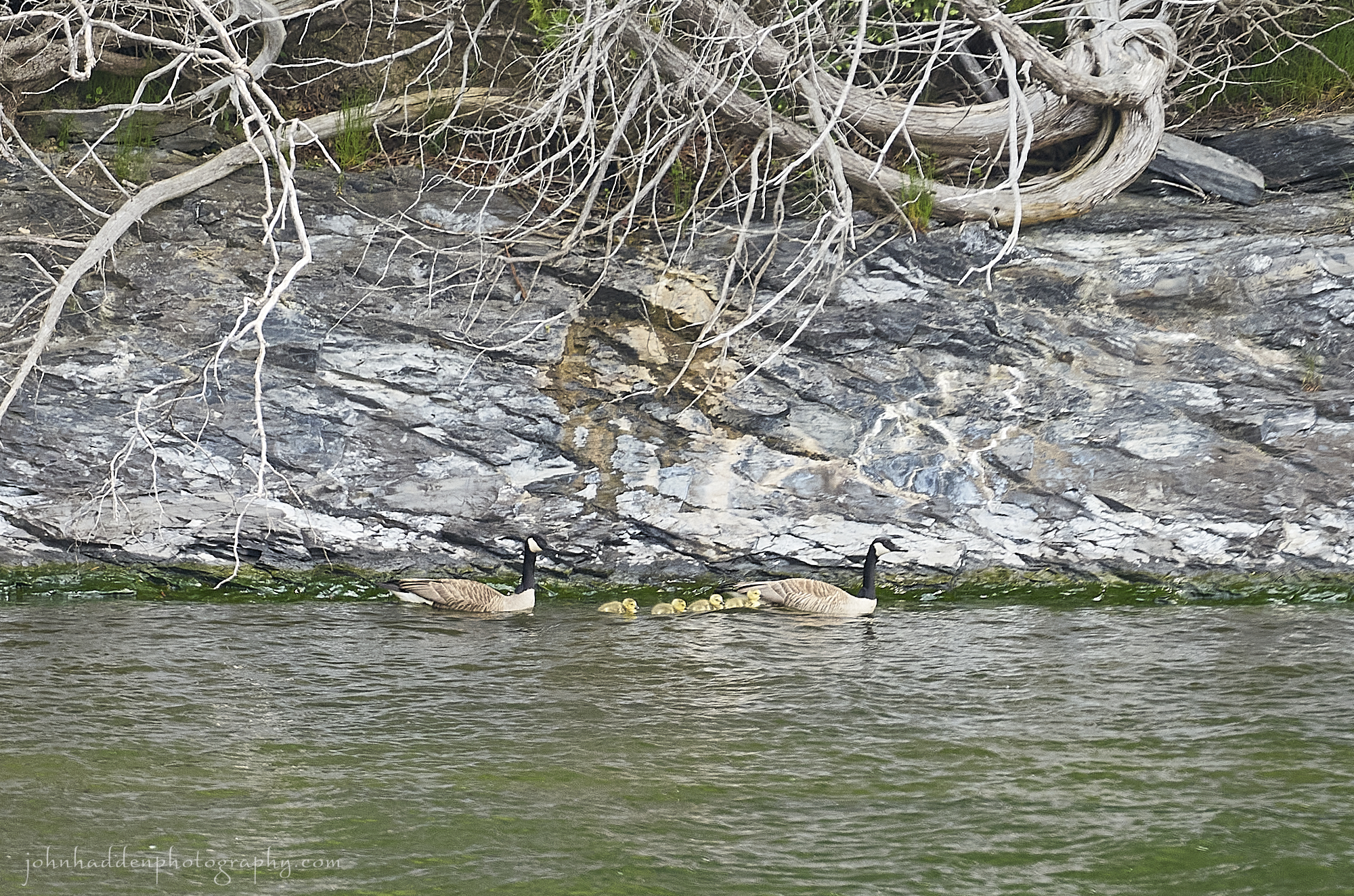
We saw our first hatch of Canada geese chicks yesterday. Mom & dad had been nesting by the little marshy area on the point, and they brought their four new fuzzy yellow chicks out for a swim in our cove.
Sony A7II, Sigma 100-400mm lens @ 400mm, ISO 800, f/8, 1/320″ exposure.
Tuesday, May 16, 2023

Elderberry blooming along the beach
Morning Observation:
This morning in North Hero at 7:05AM it’s currently 57 degrees under overcast skies. Winds are out of the south at 3-5 mph. Relative humidity is 47%l, dewpoint 37, barometric pressure 29.63”. Yesterday’s high was 68, and yesterday’s low was 49. The overnight low got down to 57.
This morning in Huntington it’s currently 53 degrees under overcast skies. Winds are calm. Relative humidity is 81%, dewpoint 47, barometric pressure 29.67”. Yesterday’s high was 71, and yesterday’s low was 33. The overnight low got down to 49.
Forecast Discussion:
Morning radar imagery shows low pressure just to the north of Lake Huron with a line of showers stretched along a cold front running west to east into Québec. This front is expected to drop into the region by this afternoon bringing its showers along with it. Given the very dry antecedent airmass over the region, there shouldn’t be a whole lot of rain in this system. Much colder air will move in behind the front overnight with frost expected in the usual cold spots by Wednesday morning. Chilly high pressure will build in Wednesday bringing clearing skies, breezy northwest winds, and highs only in the upper 40s to around 50. We might see some record-breaking cold Wednesday night as temperatures drop into the upper 20s and low 30s with widespread frost and hard freezes expected region-wide. Temperatures will begin to moderate back to more seasonable levels by Thursday with highs bumping up into the low 70s by Friday on a gusty southerly airflow.
3-Day Forecast:
We’ll see mostly cloudy skies today with showers likely, mainly after 3:00pm. Highs will be near 69 in Huntington and 61 in North Hero, dropping in the afternoon as the aforementioned front drops through. Winds will be southwesterly 8-14 mph, becoming northwesterly in the afternoon. Chance of precipitation is 60% with rainfall amounts of 0.10″-0.25″ possible. Tonight should start out cloudy with showers likely, mainly before 9:00pm. Skies should gradually become partly cloud, with a low around 35 and north winds 5-8 mph. Chance of precipitation is 60% with rainfall amounts of less than 0.10″ possible.
Wednesday should be mostly sunny with a high near 50 and northwest winds 10-16 mph. Wednesday night should be mostly clear and cold with a low around 30 and northwest winds 5-9 mph becoming calm after midnight.
Thursday should be sunny with a high near 64 and west winds 5-7 mph. Thursday night should be mostly clear with a low around 42 and light south winds increasing to 5-10 mph in the evening.
Almanac:
Last year on this date in Huntington we had a high of 82 and a low of 55. We picked up 1.05″ of rain.
Last year in North Hero we had a high of 75 and a low of 58. We picked up 0.21″ of rain.
Burlington averages for this date are a low of 48 and a high of 69.
The record low was 29 in 1987.
The record high was 87 in 1991.
The Lake Champlain lake level in Burlington is 98.35′.
The water temperature is 52˚.
Last year’s lake level was at 97.81″ (got that extra 10′ back pretty quick, huh?)
The Mt. Mansfield snow stake depth is 10″.
The average depth for this date is 22″.
Sky Notes:
Sunrise: 5:24AM
Sunset: 8:13PM
Length of day: 14:49:05
Today will be 2:11 longer than yesterday.
The Moon is a waning crescent, 26 days old with 13% illumination.
Moonrise: 3:57AM
Moonset: 5:04PM
About Today’s Photo:
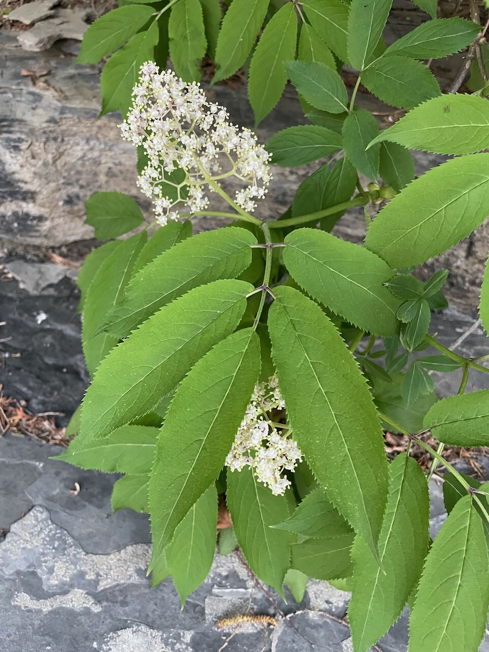
I came across this elderberry the other day blooming along our currently very small beach. I’ll have to keep an eye out for its berries later in the season.
iPhone 12 Pro
Monday, May 15, 2023
A red sun rising behind the trees
Morning Observation:
This morning in North Hero at 6:30AM it’s currently 50 degrees under clear skies. Winds are out of the south at 3-5 mph. Relative humidity is 67%, dewpoint 39, barometric pressure 30.17”. Yesterday’s high was 64, and yesterday’s low was 44. The overnight low got down to 49.
This morning in Huntington it’s currently 35 degrees under clear skies. Winds are calm. Relative humidity is 95%, dewpoint 33, barometric pressure 30.22”. Yesterday’s high was 60, and yesterday’s low was 32. The overnight low got down to 33.
Forecast Discussion:
High pressure remains in control of our weather today and will deliver another dry and sunny day with highs pushing into the upper 60s and low 70s along with gusty southwest winds. Clouds (along with smoke from Alberta wildfires) will be on the increase this afternoon out ahead of an approaching cold front and associated shortwave trough. These features are expected to drop into the region from Canada Tuesday afternoon into Wednesday bringing in a shot of much colder air along with some light rainfall Tuesday night into Wednesday. Highs on Tuesday will depend on where you are with southern areas reaching near 70, while areas near the Canadian border see only upper 50s or low 60s. Highs on Wednesday will only be in the upper 40s and low 50s with gusty west winds. We may even see some light snow cover over mountain summits by Wednesday morning. After a frosty night Wednesday night, high pressure is expected to build back in allowing temperatures to moderate back to more seasonable levels by Friday. At this point it’s looking like more showers are likely next weekend.
3-Day Forecast:
We’ll see partly sunny skies today with a high near 69 and southwest winds becoming westerly 8-15 mph. Tonight should be mostly cloudy with a low around 49 and west winds 8-15 mph.
Tuesday should be mostly cloudy with a 40% chance of showers. Highs will be near 68 with southwest winds 11-13 mph becoming northwesterly in the afternoon. Rainfall amounts of less than 0.10″ are possible. Tuesday night should be mostly cloudy with showers likely, mainly before 10pm. Lows will be around 37 with northwest winds around 10 mph. Chance of precipitation is 60% with rainfall amounts of less than 0.10″ possible.
Wednesday should be mostly sunny with a high near 50 and northwest winds 13-15 mph. Wednesday night should be mostly clear with a low around 32 and west winds 5-8 mph.
Almanac:
Last year on this date in Huntington we had a high of 76 and a low of 63. We picked up 0.84″ of rain.
Last year in North Hero we had a high of 72 and a low of 60. We picked up 0.01″ of rain.
Burlington averages for this date are a low of 48 and a high of 69.
The record low was 29 in 1971.
The record high was 88 in 1961.
The Lake Champlain lake level in Burlington is 98.45′.
The water temperature is 44˚.
Last year’s lake level was at 97.85″.
The Mt. Mansfield snow stake depth is 12″.
The average depth for this date is 24″.
Sky Notes:
Sunrise: 5:25AM
Sunset: 8:12PM
Length of day: 14:46:53
Today will be 2:14 longer than yesterday.
The Moon is a waning crescent, 25 days old with 21% illumination.
Moonrise: 3:37AM
Moonset: 3:49PM
About Today’s Photo:
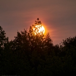
This morning’s sunrise was distinctly red-tinted. Smoke from Alberta wildfires has been affecting our region on-and-off over the past weeks as the fires burn out west. We can expect more smoke today.
Sony A7II, Sigma 100-400mm lens @ 296mm, ISO 100, f/14, 1/320″ exposure
Sunday, May 14, 2023

Elm leaves and catkins against dappling water
Happy Mothers’ Day to all you moms out there!
Morning Observation:
This morning in North Hero at 7:10AM it’s currently 49 degrees under clear skies. Winds are out of the west at 2-4 mph. Relative humidity is 57%, dewpoint 34, barometric pressure 30.27”. Yesterday’s high was 71, and yesterday’s low was 50. The overnight low got down to 44.
This morning in Huntington it’s currently 39 degrees under clear skies. Winds are calm. Relative humidity is 88%, dewpoint 36, barometric pressure 30.25”. Yesterday’s high was 71, and yesterday’s low was 42. The overnight low got down to 32.
Forecast Discussion:
Expansive high pressure to our west will continue to work its way into the North Country today bringing dry conditions through the rest of the weekend and into Monday. Highs today will be a bit cooler than yesterday—in the mid 50s to around 60s with moderate west winds. Frost will again be a concern in some of the colder pockets overnight as winds drop overnight. Monday looks to be much the same as today but with highs hitting the upper 60s to low 70s. A strong cold front is expected to swing through Tuesday afternoon bringing our next chance for precipitation along with a shot of unseasonably chilly air Tuesday night into Wednesday. We might even see some snow mixing in at elevations above 1500′ Tuesday night. Wednesday is looking raw and chilly with highs only in the 40s and 50s. Temperatures are expected to warm back to more seasonable levels for the remainder of the week.
3-Day Forecast:
We’ll see sunny skies today with a high near 60 and northwest winds 9-13 mph. Tonight should be mostly clear with a low around 36 in Huntington and 45 in North Hero with northwest winds 5-9 mph becoming light and variable.
Monday should be mostly sunny with a high near 71 an west winds 5-14 mph. Monday night should be partly cloudy with a low around 48 and southwest winds 7-10 mph.
Tuesday should bring increasing clouds with a 30% chance of showers. Highs will be near 68 with west winds 11-15 mph. Rainfall amounts of 0.10″-0.25″ are possible. Tuesday night should be mostly cloudy with showers likely. Lows will be around 35 with northwest winds around 9 mph. Chance of precipitation is 60% with rainfall amounts of 0.10″-0.25″ possible.
Almanac:
Last year on this date in Huntington we had a high of 87 and a low of 58.
Last year in North Hero we had a high of 81 and a low of 58. We picked up 0.03″ of rain.
Burlington averages for this date are a low of 47 and a high of 69.
The record low was 30 in 1967.
The record high was 88 in 2022 (see above).
The Lake Champlain lake level in Burlington is 98.58′.
The water temperature is 48˚.
The Mt. Mansfield snow stake depth is 15″.
The average depth for this date is 26″.
Sky Notes:
Sunrise: 5:26AM
Sunset: 8:11PM
Length of day: 14:44:39
Today will be 2:16 longer than yesterday.
The Moon is a waning crescent, 24 days old with 31% illumination.
Moonrise: 3:17AM
Moonset: 2:34PM
About Today’s Photo:
Morning sunlight reflects off the water backlighting young elm leaves and catkins along our shoreline. Shooting directly into the light bends the components of the image in interesting ways…
Sony A7II, Sigma 100-400mm lens @ 400mm, ISO 100, f/8, 1/3200″ exposure.
Saturday, May 13, 2023

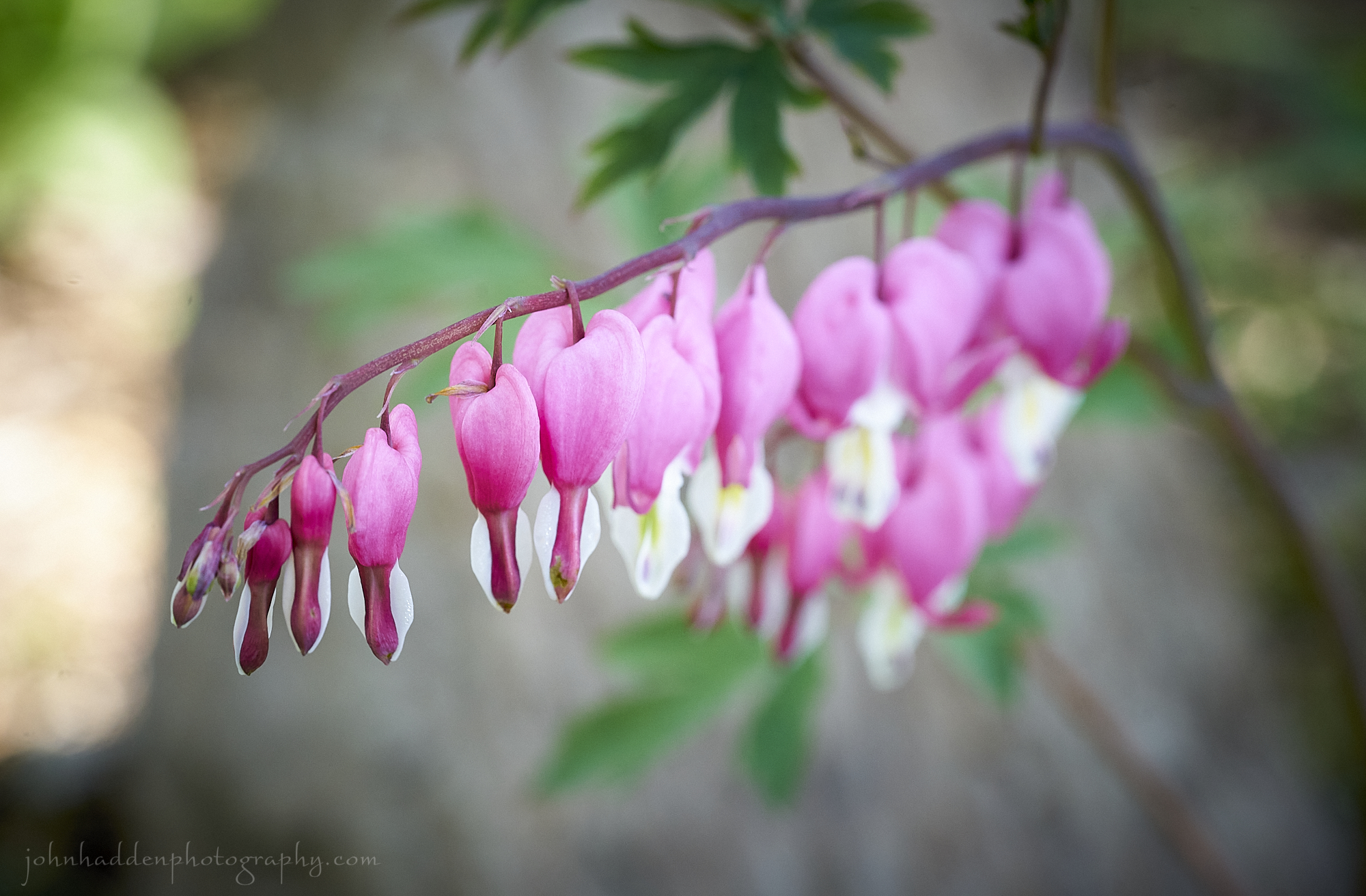
Bleeding hearts blooming in our garden
Morning Observation:
This morning in North Hero at 6:55AM it’s currently 57 degrees under clear skies. Winds are light out of the north. Relative humidity is 56%, dewpoint 41, barometric pressure 30.07”. Yesterday’s high was 78, and yesterday’s low was 54. The overnight low got down to 52.
This morning in Huntington it’s currently 51 degrees under clear skies. Winds are calm. Relative humidity is 66%, dewpoint 40, barometric pressure 30.08”. Yesterday’s high was 81, and yesterday’s low was 50. The overnight low got down to 50.
Forecast Discussion:
Cool Canadian high pressure has moved in overnight and will deliver clear and dry conditions today with highs in the upper 60s to mid 70s. With good radiational cooling tonight, some of the usual cold spots may see some frost overnight into Sunday morning. Sunday’s looking dry and sunny as well but a bit chillier with highs only in the mid 50s to low 60s. Dry and mostly seasonable conditions are expected for much of the upcoming week with the only exception being a chance of showers Monday night into Tuesday as a cold front sinks through the region. Another cool day is expected on Wednesday with highs only in the upper 50s to low 60s.
3-Day Forecast:
We’ll see sunny skies today with a high near 69 and gusty northwest winds 7-17 mph gusting to 16-21 mph in the Champlain Valley. Tonight should be mostly clear with a low around 39 and north winds 8-13 mph.
Sunday should be sunny and cool with a high near 60 and northwest winds 10-13 mph. Sunday night should be mostly clear with a low around 43 and northwest winds 5-10 mph.
Monday should be mostly sunny with a high near 71 and west winds 6-13 mph. Monday night should be mostly cloudy with a 30% chance of showers. Lows will be around 50 with west winds 7-9 mph. Rainfall amounts of less than 0.10″ are possible.
Almanac:
Last year on this date in Huntington we had a high of 88 and a low of 57.
Last year in North Hero we had a high of 81 and a low of 59.
Burlington averages for this date are a low of 47 and a high of 68.
The record low was 30 in 2010 (We had a low of 27 in Huntington).
The record high was 88 in 2022 (see above).
The Lake Champlain lake level in Burlington is 98.70′.
The water temperature is 49˚.
Last year’s lake level was at 98.05″.
The Mt. Mansfield snow stake depth is 16″.
The average depth for this date is 28″.
Sky Notes:
Sunrise: 5:27AM
Sunset: 8:09PM
Length of day: 14:42:23
Today will be 2:18 longer than yesterday.
The Moon is a waning crescent, 23 days old with 42% illumination.
Moonrise: 2:54AM
Moonset: 1:17PM
About Today’s Photo:
The growing season is a good deal further along here on Lake Champlain than in Huntington. These bleeding hearts are already in full bloom here in our garden by the lake. I went for a run at Pelot’s Point Natural Area yesterday morning expecting to see the usual carpets of Dutchman’s Breeches, but those blooms had long passed. My guess is that they bloomed several weeks back during our first “false spring”, only to be nipped by cold temperatures.
Sony A7II, Sony 90mm macro lens, ISO 1250, f/8, 1/125″ exposure.
WordPress Note: for some reason WordPress is not displaying the photo caption in the emails sent to my subscribers. Not sure why this is happening, but sorry for the inconvenience!
Friday, May 12, 2023

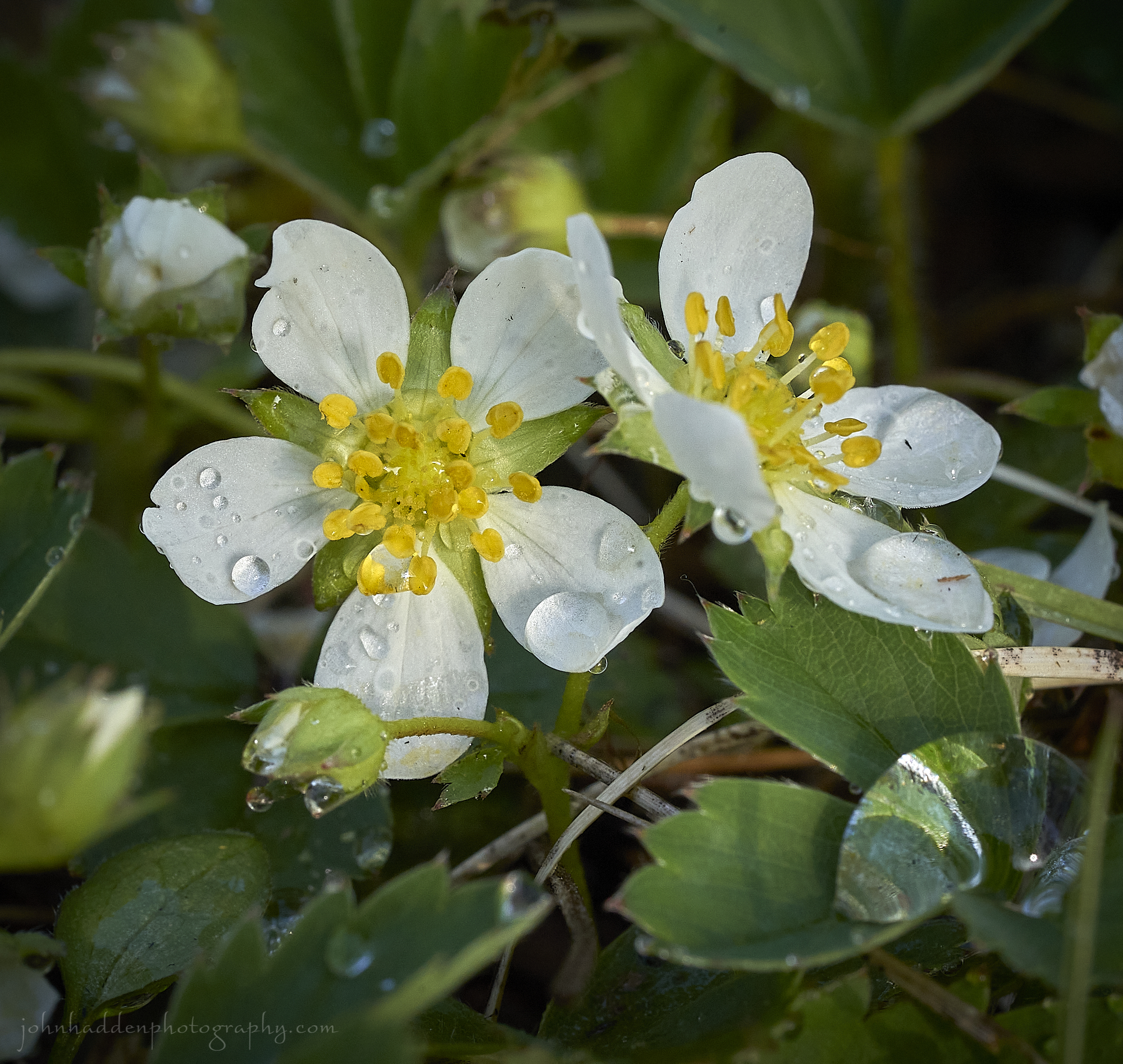
Strawberry blossoms blooming in our yard
Morning Observation:
This morning in North Hero it’s currently 56 degrees under partly cloudy skies. Winds are out of the south at 2-3 mph. Relative humidity is 91%, dewpoint 53, barometric pressure 29.95”. We picked up 0.04” of rain so far today. Yesterday’s high was 71, and yesterday’s low was 53. The overnight low got down to 54.
This morning in Huntington it’s currently 55 degrees under mostly cloudy skies. Winds are calm. Relative humidity is 96%, dewpoint 53, barometric pressure 30.00”. We picked up 0.04” of rain so far today. Yesterday’s high was 78, and yesterday’s low was 41, The overnight low got down to 50.
Forecast Discussion:
A weak shortwave trough crossing the region this morning will bring a few morning showers, but otherwise we’ll see increasing sun and temperatures as highs today top out in the upper 70s to near 80. Dry and seasonable conditions are expected through the weekend and into Monday. A series of cold fronts will drop through the region midweek dropping temperatures 10˚-15˚ below normal midweek before we warm back up later next week.
3-Day Forecast:
We’ll see mostly sunny skies today with a 30% chance of morning showers. Highs will be near 77 with southwest winds around 8 mph becoming northwesterly in the afternoon. Tonight should be partly cloudy with a low around 52 and northwest winds 3-6 mph.
Saturday should be sunny with a high near 69 and northwest winds 9-17 mph. Saturday night should be mostly clear with a low around 40 with northwest winds 7-13 mph becoming easterly in the evening.
Sunday should be sunny with a high near 60 and northwest winds 10-13 mph. Sunday night should be mostly clear with a low around 41 and west winds 3-6 mph.
Almanac:
Last year on this date in Huntington we had a high of 88 and a low of 44.
Last year in North Hero we had a high of 79 and a low of 54.
Burlington averages for this date are a low of 47 and a high of 68.
The record low was 28 in 1963.
The record high was 89 in 2022 (see above).
The Lake Champlain lake level in Burlington is 98.76′.
The water temperature is 50˚.
Last year’s lake level was at 98.15′.
The Mt. Mansfield snow stake depth is 17″.
The average depth for this date is 30″.
Sky Notes:
Sunrise: 5:28AM
Sunset: 8:08PM
Length of day: 14:40:04
Today will be 2:20 longer than yesterday.
The Moon is in its last quarter, 21.8 days old with 53% illumination.
Moonrise: 2:26AM
Moonset: 11:58AM
About Today’s Photo:
Our front “yard” here in North Hero consists mostly of wild strawberry this time of year, so right now there’s something of a lovely carpet of white blossoms on the ground. This morning’s rain left its drops behind on these blossoms.
Sony A7II, Sony 90mm macro lens, ISO 1250, f/13, 1/160″ exposure.
Thursday, May 11, 2023

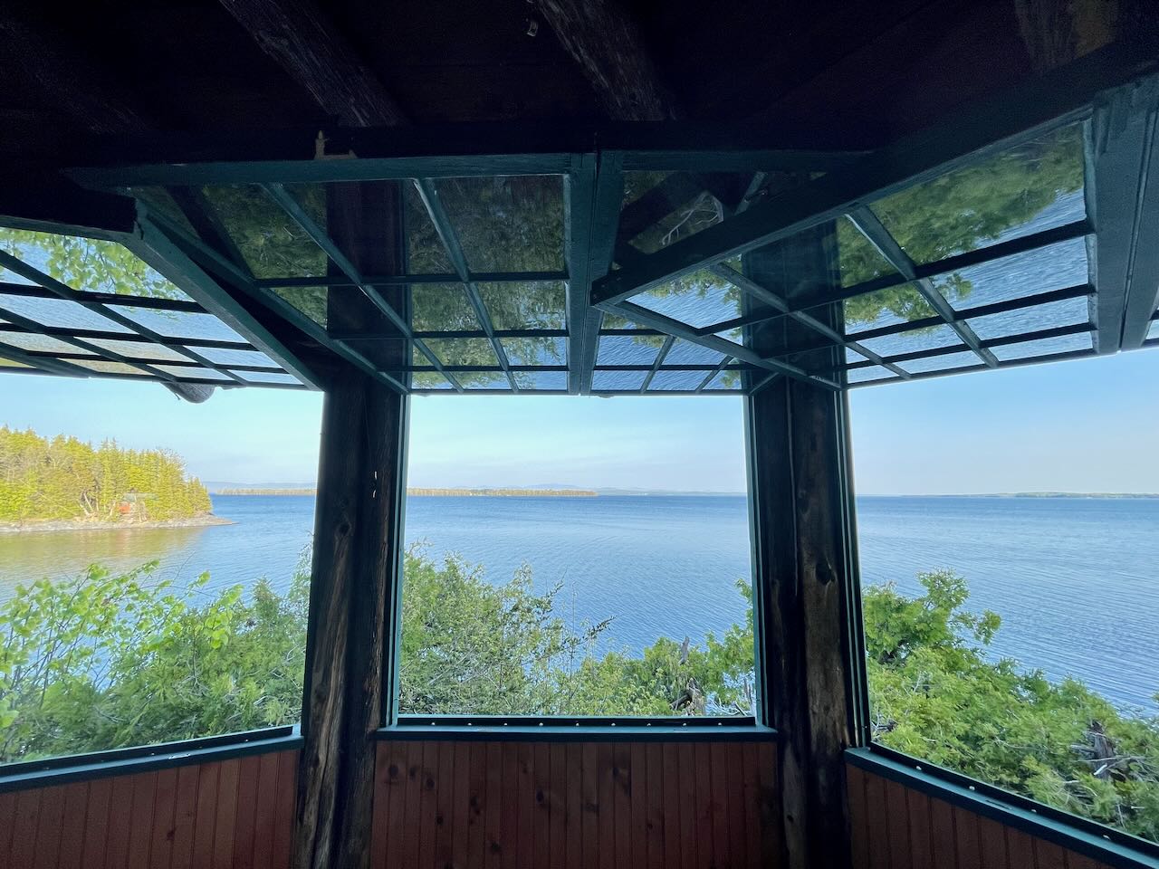
Blue water reflects in the windows of our porch here in North Hero
Morning Observation:
This morning in North Hero at 7:20AM it’s currently 56 degrees under hazy clear skies. Winds are out of the south at 3-5 mph. Relative humidity is 71%, dewpoint 46, barometric pressure 30.01”. Yesterday’s high was 72, and yesterday’s low was 46. The overnight low got down to 39.
This morning in Huntington it’s currently 48 degrees under hazy clear skies. Winds are calm. Relative humidity is 91%, dewpoint 45, barometric pressure 30.05”. Yesterday’s high was 73, and yesterday’s low was 32. The overnight low got down to 33.
Forecast Discussion:
High pressure continues to dominate with another day of warm and dry conditions expected today with highs in the mid 70s. A weak surface trough will pass to our north tonight bringing a slight chance of some showers overnight. A cold front will swing through later on Friday bringing increasing chances for showers along with perhaps a rumble of thunder as temperatures bump up into the upper 70s to low 80s. High pressure will build back in for the remainder of the weekend and into next week with dry and seasonable conditions expected.
3-Day Forecast:
We’ll see sunny skies today with a high near 76 and northwest winds 6-11 mph. Tonight should bring increasing clouds with a 30% chance of showers late. Lows will be around 54 with south winds around 6-12 mph.
Friday should be partly sunny with a 40% chance of afternoon showers. Highs will be near 80 with west winds around 7 mph. Rainfall amounts of less than 0.10″ are possible. Friday night should be mostly cloudy with a 30% chance of showers. Lows will be around 54 with west winds around 5 mph.
Saturday should be mostly sunny with a high around 70 and west winds 5-10 mph. Saturday night should be clear with a low around 40 and calm winds.
Almanac:
Last year on this date in Huntington we had a high of 84 and a low of 38.
Last year in North Hero we had a high of 80 and a low of 53.
Burlington averages for this date are a low of 46 and a high of 68.
The record low was 27 in 1966.
The record high was 85 in 2001 (we had a high of 83 in Huntington).
The Lake Champlain lake level in Burlington is 98.85′.
The water temperature is 49˚.
Last year’s lake level was at 98.26′.
The Mt. Mansfield snow stake depth is 19″.
The average depth for this date is 32″.
Sky Notes:
Sunrise: 5:29AM
Sunset: 8:07PM
Length of day: 14:37:43
Today will be 2:22 longer than yesterday.
The Moon is waning gibbous, 20.7 days old with 64% illumination.
Moonrise: 1:51AM
Moonset: 10:38AM
About Today’s Photo:
We’ve moved back up to North Hero for the summer. Clear blue skies welcomed us yesterday, and I tried to capture the reflections of the blue water in the drop-down windows of our porch. Mt. Mansfield is framed in the center of the middle window.
iPhone 12 Pro
Wednesday, May 10, 2023

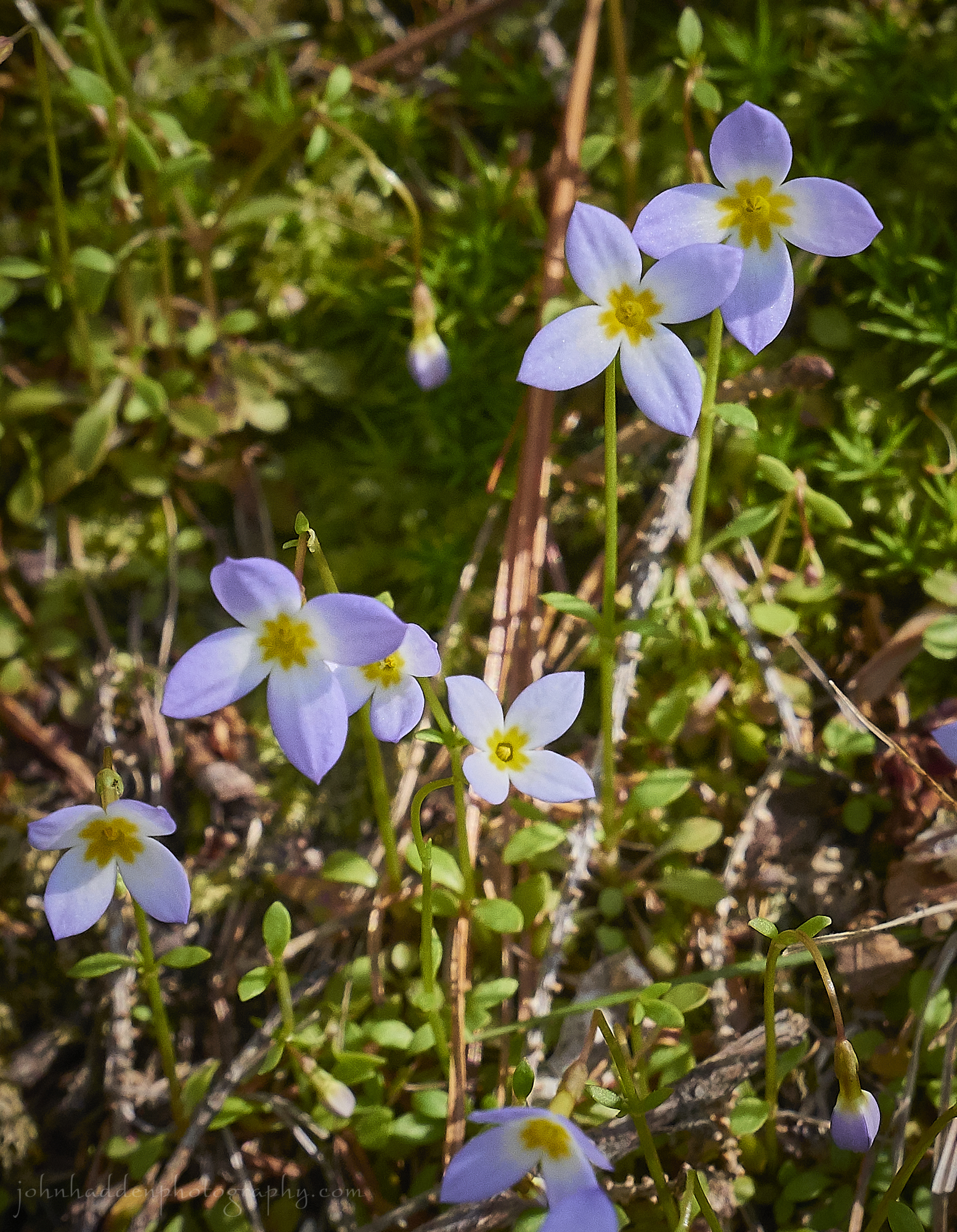
Azure bluets blooming in the woods
Morning Observation:
This morning in Huntington at 6:40AM it’s currently 34 degrees under clear skies. Winds are calm. Relative humidity is 94%, dewpoint 32, barometric pressure 30.13”. Yesterday’s high was 60, and yesterday’s low was 30. The overnight low got down to 32.
This morning in North Hero it’s currently 47 degrees under clear skies. Winds are out of the south at 7-9 mph. Relative humidity is 75%, dewpoint 40, barometric pressure 29.69”. Yesterday’s high was 61, and yesterday’s low was 43. The overnight low got down to 46.
Forecast Discussion:
We’ve got another delightful spring day on tap for today courtesy of sprawling high pressure over most of the northeast. We’ll see a warming trend kick off today as well as winds move into the south bumping temperatures into the low 70s today under clear skies. Highs Thursday will be a few degrees higher, and a weak upper level shortwave will swing through bringing a slight chance of some convective showers tomorrow afternoon. More unsettled weather is expected Friday as a shortwave trough and associated cold front swing through bringing a higher likelihood of showers Friday afternoon. Dry and seasonable conditions are expected to return for the upcoming weekend.
3-Day Forecast:
We’ll see sunny skies today with a high near 71 and south winds 6-14 in the Champlain Valley becoming northwesterly in the afternoon. Tonight should be mostly clear with a low around 48 and south winds around 6-12 mph.
Thursday should be sunny with a high near 76 and northwest winds 6-11 mph. Thursday night should bring increasing clouds with a 30% chance of showers late. Lows will be around 54 with south winds around 6-12 mph.
Friday should be partly sunny with a 40% chance of afternoon showers. Highs will be near 76 with west winds around 7 mph. Rainfall amounts of less than 0.10″ are possible. Friday night should be mostly cloudy with a 30% chance of showers. Lows will be around 54 with west winds around 5 mph.
Almanac:
Last year on this date in Huntington we had a high of 80 and a low of 37.
Last year in North Hero we had a high of 76 and a low of 50.
Burlington averages for this date are a low of 46 and a high of 67.
The record low was 25 in 1947.
The record high was 89 in 2007 (we had a high of 83 in Huntington).
The Lake Champlain lake level in Burlington is 98.94′.
The water temperature is 41˚.
Last year’s lake level was at 98.34′.
The Mt. Mansfield snow stake depth is 21″.
The average depth for this date is 34″.
Sky Notes:
Sunrise: 5:31AM
Sunset: 8:06PM
Length of day: 14:35:20
Today will be 2:24 longer than yesterday.
The Moon is waning gibbous, 19.6 days old with 75% illumination.
Moonrise: 1:01AM
Moonset: 9:21AM
About Today’s Photo:
Azure bluets are in bloom in the woods right now. These diminutive little flowers also go by the name of “Quaker ladies”, no doubt referring to their prim and proper appearance.
Canon G5X, ISO 800, f/11, 1/400″ exposure
Tuesday, May 9, 2023
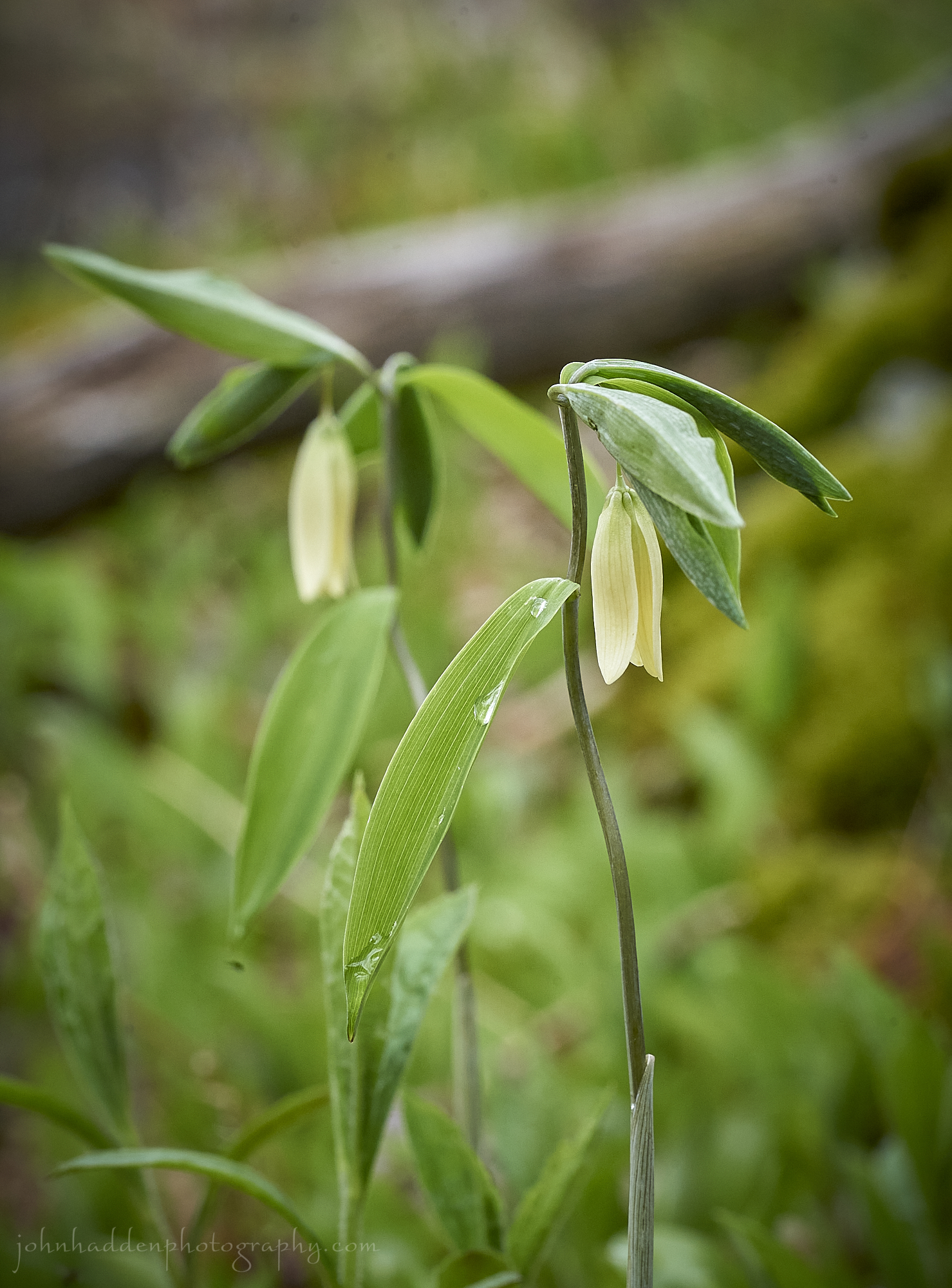
Sessile bellwort blooming in the woods
Morning Observation:
This morning in Huntington at 6:00AM it’s currently 30 degrees under clear skies. Winds are calm. Relative humidity is 93%, dewpoint 28, barometric pressure 29.98”. Yesterday’s high was 63, and yesterday’s low was 36. The overnight low got down to 30.
This morning in North Hero it’s currently 43 degrees under clear skies. Winds are calm. Relative humidity is 70%, dewpoint 34, barometric pressure 29.84”. Yesterday’s high was 66, and yesterday’s low was 49. The overnight low got down to 43.
Forecast Discussion:
High pressure over the region will continue our stretch of dry and sunny weather through Thursday. Highs today will be a bit cooler than yesterday—in the low 60s, with some frost possible in valley locations overnight once again. You may have noticed a slight orange-ish tint to the sunset yesterday. This was due to smoke from Alberta wildfires, and we might be seeing that today as well. Temperature will be on the rise by midweek with highs on Wednesday in the low 70s and mid 70s Thursday and Friday. A cold front is expected to swing through the region later on Friday bringing the chance of some showers. At this point the weekend is looking dry and seasonable.
3-Day Forecast:
We’ll see sunny skies today with a high near 60 and north winds 5-9 mph. Tonight should be clear with a low around 35 and south winds around 5 mph becoming calm in the evening.
Wednesday should be sunny with a high near 71 and west winds 5-13 mph. Wednesday night should be mostly clear with a low around 48 and southwest winds 5-7 mph.
Thursday should be mostly sunny with a high near 75 and west winds 5-7 mph. Thursday night should be partly cloudy with a low around 52 and south winds 3-6 mph.
Almanac:
Last year on this date in Huntington we had a high of 76 and a low of 32.
Last year in North Hero we had a high of 76 and a low of 41.
Burlington averages for this date are a low of 46 and a high of 67.
The record low was 28 in 1985.
The record high was 92 in 1979.
The Lake Champlain lake level in Burlington is 99.03′.
The water temperature is 43˚.
Last year’s lake level was at 98.49″.
The Mt. Mansfield snow stake depth is 25″.
The average depth for this date is 35″.
Sky Notes:
Sunrise: 5:32AM
Sunset: 8:05PM
Length of day: 14:32:55
Today will be 2:26 longer than yesterday.
The Moon is waning gibbous, 18.5 days old with 85% illumination.
Moonrise: 12:03AM
Moonset: 8:11AM
About Today’s Photo:
Sessile bellwort (a.k.a. little merrybells and wild oats) are in bloom now in the woods here in Huntington. You’ll find colonies of these drooping little yellow flowers in dry or moist woods.
Sony A7II, Sony 90mm macro lens, ISO 800, f/13, 1/160″ exposure.
Monday, May 8, 2023
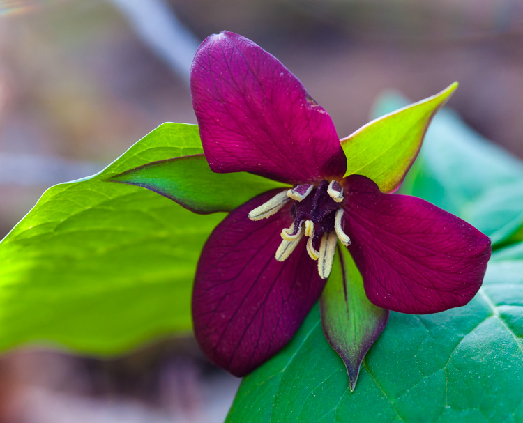
Purple trillium blooming along Taft Road
Morning Observation:
This morning in Huntington at 6:30AM it’s currently 41 degrees under clear skies. Winds are calm. Relative humidity is 95%, dewpoint 40, barometric pressure 29.74”. Yesterday’s high was 75, and yesterday’s low was 39. The overnight low got down to 41.
This morning in North Hero it’s currently 53 degrees under clear skies. Winds are calm. Relative humidity is 71%, dewpoint 44, barometric pressure 29.61”. Yesterday’s high was 74, and yesterday’s low was 51. The overnight low got down to 51.
Forecast Discussion:
We’ve got a lovely week of spring weather ahead of us courtesy of high pressure cresting over the northeast. We’ll see dry and mostly sunny conditions clear through to Friday with highs in the low to mid 60s through midweek and bumping into the 70s by Thursday. With clear skies overnight, some frost could form in colder pockets tonight and again Tuesday night. Low pressure passing to our north on Friday will bring some scattered showers Friday afternoon and evening with another round of showers possible on Sunday.
3-Day Forecast:
We’ll see sunny skies today with a high near 63 and northwest winds 7-14 mph. Tonight should be mostly clear with a low around 36 and north winds 3-7 mph.
Tuesday should be sunny with a high near 60 and north winds 5-10 mph. Tuesday night should be clear with a low around 35 and north wind 5-8 mph becoming calm in the evening.
Wednesday should be sunny with a high near 66 and northwest winds 5-10 mph. Wednesday night should be mostly clear with a low around 46 and west winds around 5 mph.
Almanac:
Last year on this date in Huntington we had a high of 67 and a low of 30.
Last year in North Hero we had a high of 69 and a low of 39.
Burlington averages for this date are a low of 45 and a high of 67.
The record low was 25 in 1962.
The record high was 88 in 2015 (we had a high of 86 in Huntington).
The Lake Champlain lake level in Burlington is 99.09′.
The water temperature is 48˚.
Last year’s lake level was at 98.57′.
The Mt. Mansfield snow stake depth is 26″.
The average depth for this date is 37″.
Sky Notes:
Sunrise: 5:33AM
Sunset: 8:04PM
Length of day: 14:30:29
Today will be 2:28 longer than yesterday.
The Moon is waning gibbous, 17.4 days old with 92% illumination.
No Moonrise
Moonset: 7:13AM
About Today’s Photo:
Purple trillium (aka Wake Robin, stinking Benjamin) is blooming now in the woods. This lovely spring ephemeral takes its more prosaic “stinking Benjamin” moniker from its rather putrid scent. At this time of year, pollinators are few, and the trillium deploys its red, meat-like color and ripe scent to attract flies to do the job of pollination. Pretty clever!
