Monday, July 31, 2017

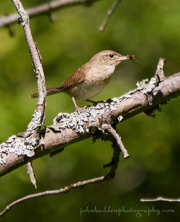
A house wren with a beakful of earwig
Morning Observation:
This morning in Huntington at 7:15AM it’s currently 59 degrees under partly cloudy skies. Winds are calm. Relative humidity is 99%, dewpoint 59, barometric pressure 30.03” and steady. Yesterday’s high was 79, and the overnight low was 51.
Forecast:
A surface cold front will drop down from Ontario and Québec this afternoon bringing chances of showers and thunderstorms later this afternoon and into the evening hours. High pressure will clear things out into Wednesday night before low pressure moving out of the Great Lakes brings more showers and thunderstorms Thursday into the weekend. Temperatures and humidity will also increase ahead of the low.
We’ll see partly sunny skies today with scattered showers and thunderstorms this afternoon. Some thunderstorms may produce heavy rainfall this afternoon. Highs will be in the lower 80s with light and variable winds, becoming westerly around 10 mph this afternoon. Chance of rain is 30%. Tonight should be partly cloudy with scattered showers and thunderstorms until midnight, then a slight chance of showers after midnight. Some thunderstorms may produce heavy rainfall until midnight. Lows will be in the upper 50s with light and variable winds. Chance of rain is 30%.
Tuesday should be be mostly sunny with highs around 80 and light and variable winds, becoming northwesterly around 10 mph in the afternoon. Tuesday night should be clear with lows in the upper 50s and light and variable winds.
Wednesday’s looking mostly sunny with a 30% chance of showers. Highs will be in the mid 80s with light and variable winds. Wednesday night should be partly cloudy with lows in the lower 60s.
Almanac:
Last year on this date we had a high of 78 and a low of 49.
Burlington averages for this date are highs of 81 and lows of 60.
The record high was 96°F in 1999.
The record low was 42°F in 1964.
Sky Notes:
Sunrise: 5:38 AM EDT
Sunset: 8:17 PM EDT
Length of Visible Light: 15h 45m
Length of Day: 14h 39m
Tomorrow will be 2m20s shorter.
The Moon is waxing gibbous, 8 days old with 56% illumination.
Moonrise: 2:27 PM EDT
Moonset: 12:24 AM EDT
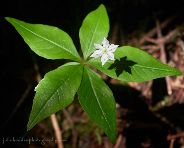
About Today’s Photo:
There’s a family of house wrens in one of our bluebird boxes in the front field. This little guy had a mouthful of earwig and was waiting for me to go away (while scolding me the whole time) before returning to the box to feed its brood.
Panasonic GX8, Lumix 100-300mm lens @ 300mm, ISO 800, f/5.6, 1/2500″ exposure.
Sunday, July 30, 2017

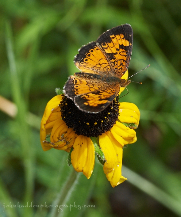
A pearl crescent visits a tired looking Susan in our front field
Morning Observation:
This morning in Huntington at 8:00AM it’s currently 57 degrees under clear skies. Winds are calm. Relative humidity is 98%, dewpoint 57, barometric pressure 30.03” and rising slowly. Yesterday’s high was 75, and the overnight low was 42.
Forecast:
We’ve got another lovely day on tap courtesy of high pressure currently over the region. A weak cold front will drop south from Quebec and could provide some isolated showers over the higher terrain north on Monday afternoon into Monday night. A slow moving low pressure system will bring widespread showers with embedded thunderstorms on Thursday and Friday.
We’ll see sunny skies today with highs in the mid 70s and north winds around 10 mph. Tonight should be clear with lows in the mid 50s and light and variable winds.
Monday should be mostly sunny with a 20% chance of showers and thunderstorms in the afternoon. Highs will be in the lower 80s with southwest winds around 10 mph, becoming west in the afternoon. Monday night should be partly cloudy with lows around 60 and northwest winds around 10 mph.
Tuesday’s looking mostly sunny with highs in the lower 80s and light and variable winds. Tuesday night should be clear with lows in the upper 50s.
Almanac:
Last year on this date we had a high of 78 and a low of 50.
Burlington averages for this date are highs of 81 and lows of 60.
The record high was 96°F in 1959.
The record low was 45°F in 1952.
Sky Notes:
Sunrise: 5:37 AM EDT
Sunset: 8:18 PM EDT
Length of Visible Light: 15h 48m
Length of Day: 14h 41m
Tomorrow will be 2m18s shorter.
The Moon is in its first quarter, 7 days old with 47% illumination.
Moonrise: 1:28 PM EDT
No Moon Set
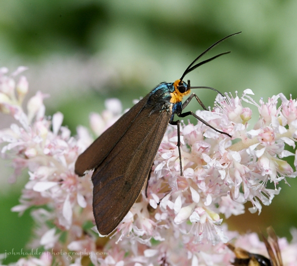
About Today’s Photo:
I was a bit up in the air about identifying this butterfly—going between a pearl crescent and a checkerspot. I’m going with the crescent, however, as the checkerspots are a tad rare for our region. Like most butterflies at this time of year, this one was a bit cagey, moving quickly from flower to flower and not settling very long for me to get a shot.
Nikon D600, Sigma 105mm macro lens, ISO 1250, f/16, 1/500″ exposure.
Saturday, July 29, 2017


A painted lady visits an ornamental thistle
Morning Observation:
This morning in Huntington at 7:15AM it’s currently 51 degrees under mostly clear skies. Winds are calm. Relative humidity is 98%, dewpoint 50, barometric pressure 29.94”. Yesterday’s high was 74, and the overnight low was 45.
Forecast:
We’ve got a stretch of fine, dry and seasonably cool weather ahead of us courtesy of high pressure which is currently building into the region. Temperatures warm back to more normal values by Monday, with our next chance for showers expected towards the middle to end of next week.
We’ll see mostly sunny skies today with highs in the lower 70s and north winds around 10 mph. Tonight should be clear with lows in the lower 50s and north winds around 10 mph until midnight, becoming light and variable.
Sunday should be sunny with highs in the mid 70s and light and variable winds, becoming northwesterly around 10 mph in the afternoon. Sunday night should be clear with lows in the mid 50s and light and variable winds.
Monday’s looking partly sunny with highs in the lower 80s and southwest winds around 10 mph. Monday night should be partly cloudy with lows in the lower 60s.
Almanac:
Last year on this date we had a high of 81 and a low of 56. We picked up 0.22″ of rain.
Burlington averages for this date are highs of 81 and lows of 60.
The record high was 98°F in 1949.
The record low was 45°F in 1987.
Sky Notes:
Sunrise: 5:36 AM EDT
Sunset: 8:19 PM EDT
Length of Visible Light: 15h 50m
Length of Day: 14h 43m
Tomorrow will be 2m16s shorter.
The Moon is a waxing crescent, 6 days old with 39% illumination.
Moonrise: 12:28 PM EDT
Moonset: 11:55 PM EDT
About Today’s Photo:
Ornamental thistles are pollinator magnets this time of year. These globular flowers attract all varieties of bees, flies, and butterflies including this painted lady. Note the butterfly’s tongue working its way deep into the flower!
Panasonic GX8, Lumix 14-140mm lens @ 140mm, ISO 800, f/8, 1/1000″ exposure.
Wednesday, July 26, 2017

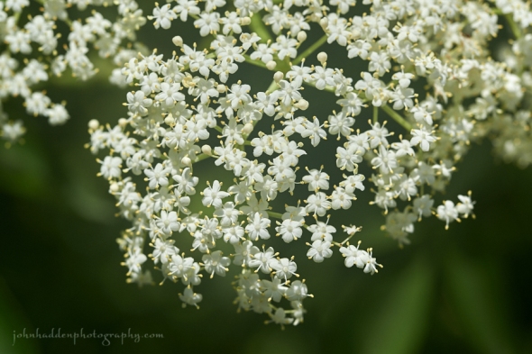
Elderberry flowerettes in bloom along East Street
Morning Observation:
This morning in Huntington at 6:55AM it’s currently 50 degrees under clear skies. Winds are calm. Relative humidity is 98%, dewpoint 49, barometric pressure 30.24”. Yesterday’s high was 70, and the overnight low was 48.
Forecast:
High pressure will crest over the region today bringing sunny skies for a good part of the day along with seasonably mild temperatures. A weak cold front will approach from the Great Lakes tonight bringing scattered to numerous showers along with a few thunderstorms overnight and into Thursdays. High pressure ehind the departing front will bring fair and seasonably warm weather by Friday and into the upcoming weekend.
We’ll see sunny skies this morning, then partly sunny skies this afternoon. It’ll be warmer with highs in the upper 70s and light and variable winds, becoming southerly around 10 mph this afternoon. Tonight should be mostly cloudy with a slight chance of showers until midnight, then showers likely after midnight. Lows will be in the lower 60s with south winds around 10 mph. Chance of rain is 60%.
Thursday should be mostly cloudy with showers likely in the morning, then a chance of showers and thunderstorms in the afternoon. Some thunderstorms may produce gusty winds, and small hail in the afternoon. Highs will be in the mid 70s with southwest winds around 10 mph. Chance of rain is 60%. Thursday night should be partly cloudy with a chance of showers and thunderstorms. Some thunderstorms may produce gusty winds, and small hail. Lows will be in the upper 50s with northwest winds around 10 mph. Chance of rain is 50%.
Friday’s looking partly sunny with highs around 70 and northwest winds around 10 mph. Friday night should be partly cloudy with lows in the mid 50s.
Almanac:
Last year on this date we had a high of 79 and a low of 59. We picked up 0.03″ of rain.
Burlington averages for this date are highs of 81 and lows of 61.
The record high was 94°F in 1939.
The record low was 45°F in 1976.
Sky Notes:
Sunrise: 5:32 AM EDT
Sunset: 8:23 PM EDT
Length of Visible Light: 15h 58m
Length of Day: 14h 50m
Tomorrow will be 2m9s shorter.
The Moon is a waxing crescent, 3 days old with 11% illumination.
Moonrise: 9:13 AM EDT
Moonset: 10:28 PM EDT
About Today’s Photo:
It’s a good year for elderberry this time around the sun. I’ve seen a profusion of bushes blossoming in my travels. The tiny flowerettes produce equally tiny berries come late summer and fall. The berries are prized for a variety of uses including fermented beverages like elderberry wine. One crafty friend of ours recommends collecting the berries in their bunches off the bush and placing them in ziplock bag which you should pop in the freezer. Once the berries are frozen, you can just shake them off!
Nikon D600, Sigma 105mm macro lens, ISO 200, f/8, 1/800″ exposure.
Tuesday, July 25, 2017

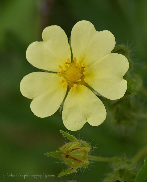
Rough-fruited cinquefoil blooming in our front field
Morning Observation:
This morning in Huntington at 7:50AM it’s currently 56 degrees under overcast skies. Relative humidity is 95%, dewpoint 54, barometric pressure 30.08” and rising rapidly. We picked up 0.58” of rain in the past 24hrs. Yesterday’s high was 68 (at 1:37AM—our daytime high was only 59), and the overnight low was 54.
Forecast:
We’ve got another cool and dampish start to the day courtesy of an upper level trough of low pressure which will slowly move east of the region this afternoon, but not before delivering a few morning showers. Skies should clear by late afternoon or early evening. High pressure will bring a short window of fair and dry weather on Wednesday, before shower and thunderstorms return Thursday into Thursday evening as a weak cold front crosses the area.
We’ll see cloudy skies with showers likely, mainly this morning. Highs will be in the mid 60s with light and variable winds. Chance of rain is 70%. Tonight should be partly cloudy with lows in the lower 50s and light and variable winds.
Wednesday should be mostly sunny and warmer with highs in the upper 70s and light and variable winds. Wednesday night should be mostly cloudy with a 30% chance of showers. Lows will be around 60 with south winds around 10 mph.
Thursday showers are likely with a chance of thunderstorms. Highs will be in the lower 70s with south winds around 10 mph. Chance of rain is 70%. Thursday night showers are likely with a chance of thunderstorms. Lows will be around 60. Chance of rain is 70%.
Almanac:
Last year on this date we had a high of 84 and a low of 55. We picked up 0.01″ of rain.
Burlington averages for this date are highs of 81 and lows of 61.
The record high was 97°F in 1963.
The record low was 45°F in 1912.
Sky Notes:
Sunrise: 5:31 AM EDT
Sunset: 8:24 PM EDT
Length of Visible Light: 16h 00m
Length of Day: 14h 52m
Tomorrow will be 2m6s shorter.
The Moon is a waxing crescent, 2 days old with 5% illumination.
Moonrise: 8:04 AM EDT
Moonset: 9:56 PM EDT
About Today’s Photo:
Cinquefoil is a French word meaning “five fingers” and refers to the arrangement of five leaves on this common flower. The lovely, buttery yellow petals certainly catch the eye!
Nikon D600, Sigma 105mm macro lens, ISO 800, f/14, 1/400″ exposure.
Monday, July 24, 2017

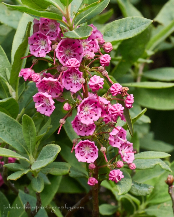
Mountain laurel blooming along the trail to Mt. Lafayette
Morning Observation:
This morning in Huntington at 8:00AM it’s currently 58 degrees and raining lightly under overcast skies. Winds are calm. Relative humidity is 95%, dewpoint 57, barometric pressure 29.90” and rising rapidly. We picked up 0.14” of rain overnight. Yesterday’s high was 77, and the overnight low was 58.
Forecast:
An upper level low will cross the region today into tonight bringing widespread rainfall and cool temperatures before exiting to the east on Tuesday. High pressure will build in Wednesday bringing a brief stretch of fair weather before a weak cold front renews the threat of showers and storms on Thursday. Fair weather then returns for Friday into next weekend with seasonable temperatures.
We’ll see showers today with highs in the lower 60s and southeast winds 10 to 15 mph gusting up to 25 mph this morning. Chance of rain is near 100%. Tonight showers are likely. Lows will be in the lower 50s with southeast winds around 10 mph until midnight, becoming light and variable. Chance of rain is 70%.
Tuesday should be cloudy with showers likely mainly in the morning. Highs will be in the mid 60s with light and variable winds. Chance of rain is 60%. Tuesday night should be partly cloudy with lows in the lower 50s and light and variable winds.
Wednesday’s looking partly sunny and warmer with highs in the upper 70s and light and variable winds. Wednesday night should be partly cloudy with lows in the lower 60s.
Almanac:
Last year on this date we had a high of 77 and a low of 54. We picked up 0.37″ of rain.
Burlington averages for this date are highs of 81 and lows of 61.
The record high was 95°F in 1987.
The record low was 45°F in 1912.
Sky Notes:
Sunrise: 5:30 AM EDT
Sunset: 8:25 PM EDT
Length of Visible Light: 16h 02m
Length of Day: 14h 54m
Tomorrow will be 2m5s shorter.
The moon is a waxing crescent, 1 day old with 1% illumination.
Moonrise: 6:53 AM EDT
Moonset: 9:20 PM EDT
About Today’s Photo:
Mountain laurel is in bloom now at higher elevations in the White Mountains. As I topped 4000′ along the Old Bridle Trail heading towards Mt. Lafayette, I entered a tunnel of this lovely evergreen shrub with profusions of bright pink flowers.
Panasonic GX8, Lumix 14-140mm lens @ 88mm, ISO 800, f/16, 1/100″ exposure.
Sunday, July 23, 2017

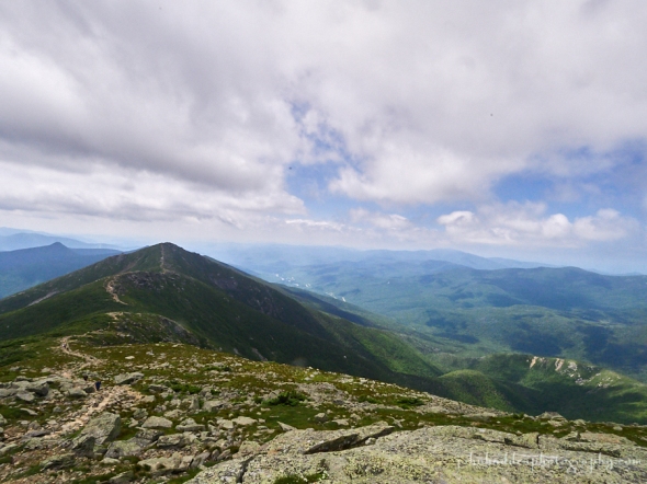
The view south along the Franconia Ridge
Morning Observation:
This morning in Huntington at 8:25AM it’s currently 60 degrees under mostly cloudy skies. Winds are calm. Relative humidity is 98%, dewpoint 59, barometric pressure 29.84” and steady. Yesterday’s high was 81, and the overnight low was 50.
Forecast:
A dry and seasonably cool day is on tap across the region today. An upper level trough will bring widespread rain late tonight through Tuesday along with much cooler temperatures. High pressure and warmer temperatures return for Wednesday, and a cold front will deliver showers and thunderstorms on Thursday.
We’ll see mostly cloudy skies today with highs in the mid 70s and light and variable Tonight should be cloudy with a slight chance of showers until midnight, then a 50% chance of showers after midnight. Lows will be in the upper 50s with light and variable winds.
Monday rain is likely with a slight chance of thunderstorms. It’ll be much cooler with highs only around 60 with southeast winds 10 to 15 mph. Chance of rain is 80%. Monday night rain is likely. Lows will be in the lower 50s with southeast winds around 10 mph. Chance of rain is 70%.
Tuesday showers are likely. Highs wil be in the mid 60s with light and variable winds. Chance of rain is 70%. Tuesday night be should partly cloudy wit lows in the mid 50s.
Almanac:
Last year on this date we had a high of 84 and a low of 59. We picked up 0.17″ or rain.
Burlington averages for this date are highs of 81 and lows of 61.
The record high was 93°F in 1952.
The record low was 46°F in 1923.
Sky Notes:
Sunrise: 5:29 AM EDT
Sunset: 8:26 PM EDT
Length of Visible Light: 16h 05m
Length of Day: 14h 56m
Tomorrow will be 2m2s shorter.
The Moon is new, 29 days old with 0% illumination.
Moonrise: 5:43 AM EDT
Moonset: 8:37 PM EDT
About Today’s Photo:
The Franconia Ridge trail is one of the iconic hikes in the northeast, rivalled in beauty perhaps only by the Presidential Range to the east. It is the second highest ridge in the northeast (the Presidentials being the tallest), and the Appalachian Trail traverses it. This view is from the summit of Mount Lafayette looking south towards Mt. Lincoln, Little Haystack Mtn, and Mt. Liberty. Franconia Notch (with the noisey I-93 running though it…) is to the west.
Panasonic GX8, Olympus 9-18mm lens @ 9mm, circular polarizing filter, ISO 800, f/18, 1/200″ exposure.
Saturday, July 22, 2017


A gregarious raven keeps an eye out for food atop Little Haystack Mtn along the Franconia Ridge
Morning Observation:
This morning in Huntington at 7:10AM it’s currently 59 degrees under partly cloudy skies. Winds are calm. Relative humidity is 99%, dewpoint 59, barometric pressure 29.85” and steady. We picked up 0.05” of rain in a quick shower that moved through at about 8:00PM last evening. Yesterday’s high was 85, and the overnight low was 56.
Forecast:
We’ll see mainly dry conditions today across the region. A weak cold front currently draped across southern Ontario and Quebec will drop through the region today, and may kick up a few isolated showers or thunderstorms across central and southern areas this afternoon. An upper level trough approaching from the Great Lakes will bring our next chance for widespread precipitation with periods of showers expected Sunday night through Monday night.
We’ll see partly sunny skies today with highs around 80 and light and variable winds, becoming northwesterly around 10 mph this afternoon. Tonight should be partly cloudy until midnight, then clearing. Lows will be in the mid 50s with north winds around 10 mph until midnight, becoming light and variable.
Sunday should be mostly sunny and cooler with highs in the mid 70s and light and variable winds, becoming northerly around 10 mph in the afternoon. Sunday night showers are likely. Lows will be in the upper 50s with light and variable winds. Chance of rain is 60%.
Monday showers are likely. It’ll be cool with highs only in the mid 60s with southeast winds around 10 mph. Chance of rain is 70%. Monday night showers arer likely. Lows will be in the mid 50s. Chance of rain is 70%.
Almanac:
Last year on this date we had a high of 90 and a low fo 62.
Burlington averages for this date are highs of 81 and lows of 61.
The record high was 97°F in 1955.
The record low was 44°F in 1914.
Sky Notes:
Sunrise: 5:28 AM EDT
Sunset: 8:27 PM EDT
Length of Visible Light: 16h 07m
Length of Day: 14h 58m
Tomorrow will be 1m59s shorter.
The Moon is a waning crescent, 28 days old with 2% illumination.
Moonrise: 4:35 AM EDT
Moonset: 7:48 PM EDT
About Today’s Photo:
I hike the Franconia Ridge in the White Mountains the other day. Two ravens were mingling with the other hikers atop Little Haystack Mountain looking for dropped food or handouts—no doubt a pretty reliable source of food for the birds. Ravens are very intelligent birds (like all corvids including crows and jays). I got the impression that these two birds hung out on the summits a lot as they were quite used to people (not necessarily a good thing…) They let me get within about 3′ of them! Mt. Lincoln is in the background looking north along the Franconia Ridge.
Tuesday, July 18, 2017

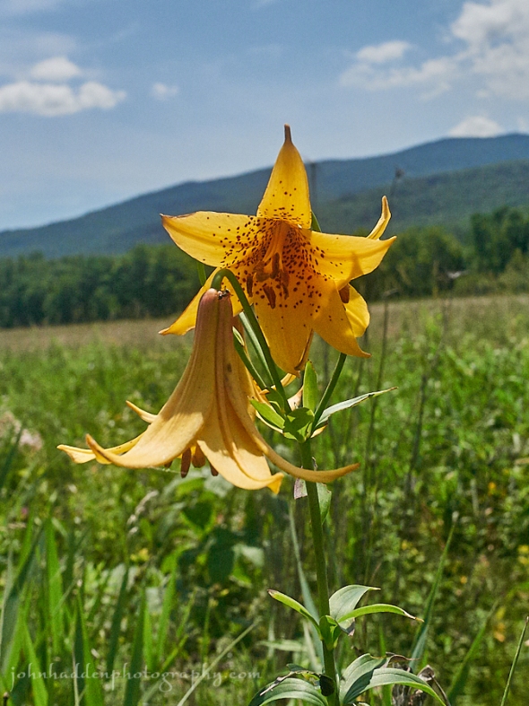
Canada lilies blooming along the Lamoille Valley Rail Trail
Morning Observation:
This morning in Huntington at 7:35AM it’s currently 66 degrees under clear skies. Winds are calm. Relative humidity is 99%, dewpoint 66, dewpoint 30.08” and rising. We picked up 0.14” of rain in the past 24hrs. Yesterday’s high was 80, and the overnight low was 57.
Forecast:
A ridge of high pressure to our south will deliver warmer and drier conditions
to the region today and tomorrow before a cold front moves in on Thursday and Friday with a chance of showers and thunderstorms.
We’ll see partly sunny skies today with highs in the lower 80s and light and variable winds. Tonight should be clear with lows in the lower 60s and light and variable winds.
Wednesday should be mostly sunny with a slight chance of showers northwest in the afternoon. Highs will be in the mid 80s with light and variable winds, becoming southwesterly around 10 mph in the afternoon. Wednesday night should be partly cloudy with lows in the mid 60s and west winds around 10 mph.
Thursday’s looking artly sunny with a chance of showers and thunderstorms. Highs will be in the lower 80s with light and variable winds. Chance of rain is 30%. Thursday night should be partly cloudy with lows in the mid 60s.
Almanac:
Last year on this date we had a high of 80 and a low of 59.
Burlington averages for this date are highs of 81 and lows of 61.
The record high was 99°F in 1953.
The record low was 47°F in 1956.
Sky Notes:
Sunrise: 5:24 AM EDT
Sunset: 8:30 PM EDT
Length of Visible Light: 16h 15m
Length of Day: 15h 06m
Tomorrow will be 1m48s shorter.
The Moon is a waning crescent, 23.7 days old with 33% illumination.
Moonrise: 1:16 AM EDT
Moonset: 3:23 PM EDT
About Today’s Photo:
We took a bike ride along the Lamoille Valley Rail Trail between Jeffersonville and Johnson the other day. Among the profuse number of wildflowers blooming were these lovely Canada lilies (Lilium canadense). These stately lilies can grow to 3′-4′ tall and I saw several stalks sporting more than six or seven blossoms at a time.
Panasonic GM5, Lumix 12-32mm lens @ 15mm, ISO 800, f/5.6, 1/8000″ exposure.
Monday, July 17, 2017


A crab spider lurks on a black-eyed Susan
Morning Observation:
This morning in Huntington at 7:25AM it’s currently 63 degrees under partly cloudy skies. Winds are calm. Relative humidity is 98%, dewpoint 62, barometric pressure 30.02” and steady. Yesterday’s high was 83, and the overnight low was 56.
Forecast:
A slow moving trough approaching from southern Ontario will bring numerous showers and thunderstorms to the region today, especially this afternoon and evening. A few stronger storms are possible with small hail, gusty winds, and
brief heavy rainfall. The trough will move east on Tuesday but some lingering showers or thunderstorms are possible especially over eastern Vermont. A ridge of high pressure will bring warmer and drier conditions to the region on Wednesday before another frontal system moves though on Thursday and Friday bringing a chance of showers and thunderstorms.
We’ll see partly sunny skies today with a chance of showers and a slight chance of thunderstorms this morning, then mostly cloudy skies with showers and thunderstorms likely this afternoon. Some thunderstorms may produce gusty winds, small hail, and heavy rainfall this afternoon. Highs will be in the lower 80s with light and variable winds, becoming southerly around 10 mph this afternoon. Chance of rain is 70%. Tonight should be mostly cloudy with showers and thunderstorms likely, mainly until midnight. Some thunderstorms may produce gusty winds, small hail, and heavy rainfall until midnight. Lows will be in the lower 60s with southeast winds around 10 mph until midnight, becoming light and variable. Chance of rain is 70%.
Tuesday should be partly sunny with a slight chance of thunderstorms and a 40% chance of showers, mainly in the morning. Highs will be in the lower 80s with south winds around 10 mph. Tuesday night should be partly cloudy with lows in the mid 60s and light and variable winds.
Wednesday’s looking mostly sunny with highs in the mid 80s and southwest winds around 10 mph. Wednesday night should be partly cloudy with 30% a chance of showers. Lows will be in the mid 60s.
Almanac:
Last year on this date we had a high of 81 and a low of 57.
Burlington averages for this date are highs of 81 and lows of 61.
The record high was 97°F in 1999 (we had a high of 93).
The record low was 47°F in 1908.
Sky Notes:
Sunrise: 5:24 AM EDT
Sunset: 8:31 PM EDT
Length of Visible Light: 16h 17m
Length of Day: 15h 07m
Tomorrow will be 1m45s shorter.
The Moon is a waning crescent, 22.6 days old with 44% illumination.
Moonrise: 12:41 AM EDT
Moonset: 2:12 PM EDT
About Today’s Photo:
The name “crab spider” applies to a broad range of spiders in the family Thomisidae. There are over 2000 species in this family world-wide. Crab spiders hunt by ambushing their prey (instead of building webs). Some, like the spider here, have coloration that mimics the flower they’re perched on, and can even change color over the course of a couple days to match their surroundings.
Nikon D600, Sigma 105mm macro lens, ISO 1250, f/13, 1/800″ exposure.
Sunday, July 16, 2017


A hoverfly visits blooming chickory along East Street.
Morning Observation:
This morning in Huntington at 8:20AM it’s currently 69 degrees under clear skies. Winds are calm. Relative humidity is 93%, dewpoint 67, barometric pressure 29.92” and rising. We picked up 0.01” of rain in the past 24hrs. Yesterday’s high was 79, and the overnight low was 56.
Forecast:
Weak surface high pressure will bring light winds and warmer temperatures to the region today, with afternoon highs generally in the low to mid 80s in the valleys. Along with some passing mid-level clouds, there’s a slight chance of a shower this afternoon across northern New York and far northeastern Vermont. A slow moving upper level trough will bring numerous showers and some embedded thunderstorms to the region Monday afternoon. Additional showers are possible on Tuesday.
We’ll see partly sunny skies today with highs in the lower 80s and light and variable winds. Tonight should be partly cloudy with a 20% chance of showers and thunderstorms. Lows will be in the lower 60s with light and variable winds.
Monday should be partly sunny with a chance of showers and thunderstorms in the morning, then mostly cloudy with showers and thunderstorms likely in the afternoon. Some thunderstorms may produce gusty winds, small hail, and heavy rainfall in the afternoon. Highs will be in the lower 80s with light and variable winds, becoming southerly around 10 mph in the afternoon. Chance of rain is 70%. Monday night showers and thunderstorms are likely. Some thunderstorms may produce gusty winds, small hail, and heavy rainfall. Lows will be in the lower 60s with southeast winds around 10 mph. Chance of rain is 70%.
Tuesday’s looking partly sunny with a 40% chance of showers. Highs will be in the lower 80s with south winds around 10 mph. Tuesday night should be partly cloudy with a 30% chance of showers. Lows will be in the lower 60s.
Almanac:
Last year on this date we had a high of 78 and low of 60. We picked up 0.04″ of rain.
Burlington averages for this date are highs of 81 and lows of 61.
The record high was 94°F in 1969.
The record low was 44°F in 1946.
Sky Notes:
Sunrise: 5:23 AM EDT
Sunset: 8:32 PM EDT
Length of Visible Light: 16h 19m
Length of Day: 15h 09m
Tomorrow will be 1m41s shorter.
The Moon is in its last quarter, 21.6 days old with 55% illumination.
Moonrise: 12:10 AM EDT
Moonset: 1:02 PM EDT
About Today’s Photo:
Chickory is such a summer flower. It’s various shades of blue—from cool, pale whitish to deep sky blue—create lovely splashes of color along roadsides this time of year. They’re also a magnet for pollinators like this hoverfly.
Nikon D600, Sigma 105mm macro lens, ISO 1250, f/18, 1/800″ exposure.
Saturday, July 15, 2017

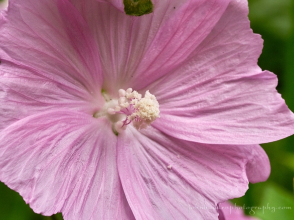
Musk mallow blooming along Taft Road
Morning Observation:
This morning in Huntington at 7:35AM it’s currently 65 degrees under overcast skies. Winds are calm. Relative humidity is 96%, dewpoint 64, barometric pressure 29.90” and steady. We picked up 0.05” of rain in the past 24hrs. Yesterday’s high was 69, and the overnight low was 62.
Forecast:
A weak trough of low pressure will track eastward across the region bringing a few light rain showers this morning and mainly across central and eastern Vermont this afternoon. Partly sunny skies will develop this afternoon allowing temperatures to warm into the upper 70s in valley locations. The warming trend will continue on Sunday with valley highs in the low to mid 80s and just a slight chance of showers. A slow moving upper low will bring more numerous showers and a chance of embedded thunderstorms on Monday and Tuesday.
We’ll see mostly cloudy skies today with a 50% chance of showers and a slight chance of thunderstorms this afternoon. Highs will be in the mid 70s with southwest winds around 10 mph, becoming northwesterly this afternoon. Tonight should be partly cloudy with a 20% chance of showers until midnight. Lows will be in the lower 60s with light and variable winds.
Sunday should be partly sunny with highs in the lower 80s and light and variable winds. Sunday night should be partly cloudy with a 30% chance of showers. Lows will be in the lower 60s with light and variable winds.
Monday showers and thunderstorms are likely. Some thunderstorms may produce heavy rainfall. Highs will be in the lower 80s with south winds 10 to 15 mph gusting up to 25 mph. Chance of rain is 60%. Monday night should be mostly cloudy with a 50% chance of showers and thunderstorms. Some thunderstorms may produce heavy rainfall. Lows will be in the lower 60s.
Almanac:
Last year on this date we had a high of 85 and a low of 62. We picked up 0.59″ of rain.
Burlington averages for this date are highs of 81 and lows of 61.
The record high was 93°F in 1955.
The record low was 44°F in 1960.
Sky Notes:
Sunrise: 5:22 AM EDT
Sunset: 8:33 PM EDT
Length of Visible Light: 16h 21m
Length of Day: 15h 11m
Tomorrow will be 1m39s shorter.
The Moon is waning gibbous, 20.6 days old with 66% illumination.
No Moon Rise
Moonset: 11:54 AM EDT
About Today’s Photo:
Musk Mallow (Malva moschata) is blooming now along roadsides and in fields. This showy pink flower was originally introduced as an ornamental from its native Europe into North America where it was widely planted in perennial flower gardens.
Panasonic GX8, Olympus 60mm macro, ISO 800, f/11, 1/320″ exposure.
Thursday, July 13, 2017

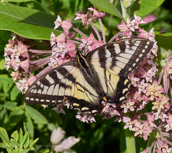
A tiger swallowtail works the nectar of milkweed outside of Danville, VT
Morning Observation:
This morning in Huntington at 7:30AM it’s currently 60 degrees and drizzling lightly under overcast skies. Winds are calm. Relative humidity is 97%, dewpoint 59, barometric pressure 29.95” and steady. We picked up 0.25” of rain overnight. Yesterday’s high was 81, and the overnight low was 59.
Forecast:
A sluggish east-west oriented frontal boundary will settle southward across
the region today bringing showers and cool conditions for mid-July. Highs today will range from the mid to upper 60s in many areas, with a few lower 70s in the southern valleys. After a mainly quiet period tonight, an upper level disturbance approaching from the northern Great Lakes will allow the frontal boundary to slide northward as a warm front on Friday bringing renewed chances for showers and a few embedded thunderstorms mainly Friday afternoon and evening. A return to drier, more seasonable conditions looks to be in the cards for the weekend.
We’ll see cloudy skies with a 50% chance of showers today. Highs will be in the mid 60s with light and variable winds. Tonight should be mostly cloudy with a 20% chance of showers. Lows will be in the mid 50s with southeast winds around 10 mph.
Friday should be cloudy with a slight chance of showers in the morning, then a 50% chance of showers in the afternoon. Highs will be in the upper 60s with southeast winds around 10 mph. Friday night showers are likely. Lows will be in the upper 50s with southeast winds 10 to 15 mph. Chance of rain is 70%.
Saturday’s looking partly sunny with a 50% chance of showers. Highs will be in the mid 70s with light and variable winds. Saturday night should be partly cloudy with lows around 60.
Almanac:
Last year on this date we had a high of 88 and a low of 58.
Burlington averages for this date are highs of 81 and lows of 61.
The record high was 96°F in 1995.
The record low was 45°F in 1940.
Sky Notes:
Sunrise: 5:20 AM EDT
Sunset: 8:34 PM EDT
Length of Visible Light: 16h 25m
Length of Day: 15h 14m
Tomorrow will be 1m32s shorter.
The Moon is waning gibbous, 18.6 days old with 84% illumination.
Moonrise: 11:11 PM EDT
Moonset: 9:44 AM EDT
About Today’s Photo:
This tiger swallowtail butterfly was very patient with me as I snapped its photo along the road outside of Danville, VT the other day. We have two species of swallowtail common to Vermont, the eastern and Canadian. I’m hard pressed to distinguish whether this one (whose wings are a bit beat up) is one or the other…
Panasonic GX8, Lumix 14-140mm lens @ 88mm, ISO 800, f/11, 1/1300″ exposure.
Wednesday, July 12, 2017


Daisy fleabane in bloom in our front field
Morning Observation:
This morning in Huntington at 7:45AM it’s currently 69 degrees under clear skies. Winds are calm. Relative humidity is 95%, dewpoint 68, barometric pressure 29.95” and steady. Yesterday’s high was 83, and the overnight low was 62.
Forecast:
A weak frontal boundary draped across the region will continue to push across our forecast area today with a few isolated showers possible across southern sections. This front will lift back north as a warm front tonight with additional showers and embedded thunderstorms likely. A widespread rainfall is expected Thursday with amounts between one half and one inch anticipated. More unsettled weather is expected to prevail going into this weekend.
We’ll see partly sunny skies today with highs in the upper 70s and light and variable winds, becoming northerly around 10 mph this afternoon. Tonight should be partly cloudy with a slight chance of showers until midnight, then cloudy with showers likely after midnight. Lows will be in the upper 50s with northeast winds around 10 mph, becoming southeasterly after midnight. Chance of rain is 70%.
Thursday showers are likely. Highs will be in the upper 60s with southeast winds around 10 mph in the morning, becoming light and variable. Chance of rain is 70%. Thursday night should be partly cloudy with lows in the upper 50s and east winds around 10 mph.
Friday’s looking mostly cloudy with a 40% chance of showers. Highs will be in the upper 60s with southeast winds around 10 mph. Friday night showers are likely. Lows will be in the upper 50s. Chance of rain is 70%.
Almanac:
Last year on this date we had a high of 83 and a low of 51.
Burlington averages for this date are highs of 81 and lows of 61.
The record high was 96°F in 1948.
The record low was 46°F in 1971.
Sky Notes:
Sunrise: 5:19 AM EDT
Sunset: 8:35 PM EDT
Length of Visible Light: 16h 26m
Length of Day: 15h 15m
Tomorrow will be 1m28s shorter.
The Moon is waning gibbous, 17.7 days old with 90% illumination.
Moonrise: 10:40 PM EDT
Moonset: 8:41 AM EDT
About Today’s Photo:
Daisy fleabane (Erigeron annuus) is a common flower blooming this time of year. It is considered a “pioneer species” — a native plant that often colonizes disturbed areas such as pastures, abandoned fields, vacant lots, roadsides, railways, and waste areas.
Monday, July 10, 2017

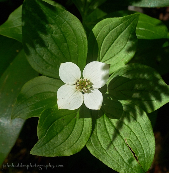
Bunch berry in bloom along the trail on Camel’s Hump
Morning Observation:
This morning in Huntington at 7:50AM it’s currently 66 degrees under mostly cloudy skies. Winds are out of the north at 2-5 mph. Relative humidity is 84%, dewpoint 62, barometric pressure 29.95” and steady. Yesterday’s high was 77, and the overnight low was 59. We picked up 1.22” of rain during the day on Saturday.
Forecast:
Active weather continues with showers and an embedded rumble of thunder or two expected through midday before some clearing develops by mid afternoon. Additional showers will redevelop toward Tuesday morning especially over
central Vermont. A cold front will produce more scattered showers and storms on Tuesday afternoon before a bubble of high pressure brings some drying on Wednesday.
We’ll see mostly cloudy skies today with a 50% chance of showers and a slight chance of thunderstorms this afternoon. Highs will be in the upper 70s with southwest winds 10 to 15 mph. Tonight should be partly cloudy until midnight, then become mostly cloudy with a 50% chance of showers with a slight chance of thunderstorms. Lows will be in the mid 60s with south winds 10 to 15 mph.
Tuesday should be cloudy with showers likely with a slight chance of thunderstorms in the morning, then partly sunny with a chance of showers and thunderstorms in the afternoon. Highs will be around 80 with south winds around 10 mph, becoming westerlty in the afternoon. Chance of rain is 70%. Tuesday night should be partly cloudy with a 50% chance of showers and thunderstorms. Lows will be in the upper 50s with northwest winds around 10 mph.
Wednesday’s looking partly sunny and less humid with highs in the lower 70s and north winds around 10 mph. Wednesday night showers are likely as the next round of low pressure moves out of the Great Lakes. Lows in the mid 50s. Chance of rain is 70%.
Almanac:
Last year on this date we had a high of 66 and a low of 58. We picked up 0.40″ of rain.
Burlington averages for this date are highs of 81 and lows of 60.
The record high was 96°F in 1911.
The record low was 45°F in 1942.
Sky Notes:
Sunrise: 5:17 AM EDT
Sunset: 8:36 PM EDT
Length of Visible Light: 16h 29m
Length of Day: 15h 18m
Tomorrow will be 1m21s shorter.
The Moon is waning gibbous, 15.8 days old with 98% illumination.
Moonrise: 9:31 PM EDT
Moonset: 6:41 AM EDT
About Today’s Photo:
Bunchberry (Cornus canadensis) is still in bloom at higher elevations. This low growing member of the dogwood family grows in clonal colonies on the forest floor. It produces bunches of bright red berries that are apparently edible with a mild apple flavor (I’ll have to give ’em a try…)
Panasonic GM5, Lumix 12-32mm lens @ 32mm, ISO 800, f/8, 1/1000″ exposure.
Saturday, July 8, 2017

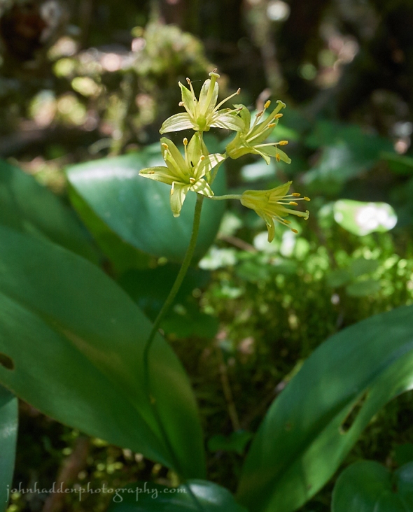
Clinton flowering along the trail on Camel’s Hump
Morning Observation:
This morning in Huntington at 8:15AM it’s currently 67 degrees under cloudy skies. Winds are calm. Relative humidity is 99%, dewpoint 67, barometric pressure 29.64” and steady. We picked up just the barest trace of rain in the past 24hrs. Yesterday’s high was 83, and the overnight low was 58.
Forecast:
A line of powerful thunderstorm is already nosing into the region this morning in a line from Burlington north towards Morrisville. Showers and thunderstorms will rumble eastward across Vermont during the mid to late morning hours. A few of these storms may produce heavy downpours and strong, gusty winds. This convective activity is expected to exit east early this afternoon as a cold front sweeps across the region bringing partial clearing and drier conditions
later in the day. Slightly cooler temperatures and lower humidity levels are expected on Sunday. A broad mid-level trough over eastern Canada will make for unsettled conditions through much of the upcoming work week.
We’ll see a chance of thunderstorms and showers this morning, then showers are likely this afternoon. Some thunderstorms may produce gusty winds, and heavy rainfall. Highs will be in the mid 70s with light and variable winds, becoming westerly around 10 mph this afternoon. Chance of rain is 80%. Tonight should be partly cloudy with a 40% chance of showers and thunderstorms until midnight, then clear after midnight. Lows will be in the mid 50s with west winds around 10 mph until midnight, becoming light and variable.
Sunday should start out sunny in the morning, then become partly sunny with a slight chance of showers in the afternoon. Highs will be in the mid 70s with southwest winds around 10 mph. Chance of rain is 20%. Sunday night should be mostly cloudy with lows in the upper 50s and southwest winds around 10 mph.
Monday’s looking mostly cloudy with a 30% chance of showers. Highs will be in the lower 70s with southwest winds around 10 mph. Monday night should be mostly cloudy with a 40% chance of showers. Lows will be in the lower 60s.
Almanac:
Last year on this date we had a high of 77 and a low of 63. We picked up 1.53″ of rain.
Burlington averages for this date are highs of 81 and lows of 60.
The record high was 98°F in 1921.
The record low was 40°F in 1969.
Sky Notes:
Sunrise: 5:16 AM EDT
Sunset: 8:37 PM EDT
Length of Visible Light: 16h 32m
Length of Day: 15h 21m
Tomorrow will be 1m14s shorter.
The Moon is the full “Buck” moon (Northeast Native American).
14d9h old with 100% illumination.
Moonrise: 8:07 PM EDT
Moonset: 4:56 AM EDT
Other names for this month’s full moon include: “Summer” (Colonial American), “Hay” (English), “Claiming” (Celtic), “Mead” (Medieval Wiccan), and “Rose” (Neo-Pagan Wiccan).
About Today’s Photo:
Clintonia (a.k.a. Blue Bead Berry, Bead Lilies, Clinton’s Lily, Corn Lily, Snakeberry, Dogberry, and Cow Tongue) is native to the US northeast and Canada. This lovely yellow flower sets a large blue-to-black fruit later in summer. Don’t be tempted to eat the berries, however, as they’ll make you sick!
Panasonic GM5, Lumix 12-32mm lens @ 32mm, ISO 800, f/5.6, 1/125″ exposure.
Friday, July 7, 2017

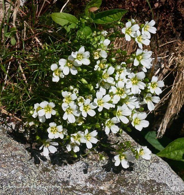
Mountain sandwort in bloom beneath the summit of Camel’s Hump
Morning Observation:
This morning in Huntington at 7:15AM it’s currently 70 degrees under mostly cloudy skies. Winds are light out of the west at 0-3 mph. Relative humidity is 76%, dewpoint 62, barometric pressure 29.81” and dropping slowly. Yesterday’s high was 79, and the overnight low was 61.
Forecast:
A trough of low pressure moving up the New England coast and a second trough approaching from the Great Lakes this morning will bring increasing chances for showers across northern New York this afternoon with a into Vermont this evening. A cold front will move in on Saturday bringing more widespread showers and thunderstorms. Friday and Saturday’s rainfall should be around a half inch to one inch with the highest totals expected across northern New York and along the international border in Vermont. Rain should taper off later Saturday night with but pick up a bit again later Sunday as another trough moves in from the northweast.
We’ll see partly sunny skies today with isolated showers this morning, then scattered showers with isolated thunderstorms this afternoon. Highs will be in the lower 80s with south winds 10 to 15 mph. Chance of rain is 50%. Tonight should be partly cloudy until midnight, then becoming mostly cloudy with scattered showers with isolated thunderstorms after midnight. Lows will be in the lower 60s with south winds around 10 mph. Chance of rain is 50%.
Saturday should bring occasional showers with isolated thunderstorms. Highs will be in the lower 70s with southwest winds around 10 mph, becoming westerly in the afternoon. Chance of rain is 80%. Saturday night should be partly cloudy with a 50% chance of showers. Lows will be in the mid 50s with west winds around 10 mph.
Sunday’s looking partly sunny with a 40% chance of showers. Highs will be in the lower 70s with southwest winds 10 to 15 mph. Sunday night should be mostly cloudy with a 50% chance of showers. Lows will be in the mid 50s.
Almanac:
Last year on this date we had a high of 85 and a low of 64.
Burlington averages for this date are highs of 81 and lows of 60.
The record high was 96°F in 1908.
The record low was 43°F in 1965.
Sky Notes:
Sunrise: 5:15 AM EDT
Sunset: 8:37 PM EDT
Length of Visible Light: 16h 34m
Length of Day: 15h 22m
Tomorrow will be 1m11s shorter.
The Moon is waxing gibbous, 13 days old with 97% illumination.
Moonrise: 7:19 PM EDT
Moonset: 4:10 AM EDT
About Today’s Photo:
Mountain sandwort is in bloom on the summit of Camel’s Hump. This diminutive, low growing plant is native to our alpine regions along the higher peaks of the Green Mountains in Vermont. It creates lovely carpets of tiny white flowers. Please be careful not to step on it (or any other bit o’ green!) when you’re up on the summit!
Panasonic GM5, Lumix 12-32mm lens @ 32mm, ISO 800, f/13, 1/1600″ exposure.
Thursday, July 6, 2017

Starflower blooming along the trail on Camel’s Hump
Morning Observation:
This morning in Huntington at 7:40AM it’s currently a balmy 71 degrees under mostly clear skies. Winds are light out of the southeast at 0-4mph. Relative humidity is 66%, dewpoint 59, barometric pressure 30.06” and steady. Yesterday’s high was 83, and the overnight low was 57.
Forecast:
High pressure will slip off the east coast today giving way to several low pressure areas and their accompanying fronts arriving from the west. We’ll see increased chances for showers and thunderstorms heading into the weekend. While some brief locally moderate rainfall events are possible, there will breaks in the rainfall so none of the days are expected to be a washout. Temperatures will
remain near normal with highs in the upper 70s to lower 80s and lows in the upper 50s to mid 60s.
We’ll see partly sunny skies today with highs around 80 and south winds 10 to 15 mph gusting up to 25 mph. Tonight should be partly cloudy with lows in the lower 60s and south winds 10 to 15 mph.
Friday should be partly sunny with a slight chance of showers in the morning, then showers likely with a slight chance of thunderstorms in the afternoon. Highs will be in the upper 70s with south winds 10 to 15 mph. Chance of rain is 70%. Friday night showers are likely. Lows will be in the lower 60s with southwest winds around 10 mph. Chance of rain is 60%.
Saturday showers are likely. Highs will be in the mid 70s with southwest winds around 10 mph. Chance of rain is 70%. Saturday night should be partly cloudy with a 50% chance of showers. Lows will be in the mid 50s.
Almanac:
Last year on this date we had a high of 88 and a low of 56.
Burlington averages for this date are highs of 81 and lows of 60.
The record high was 95°F in 2010 (we had a high of 91).
The record low was 39°F in 1962.
Sky Notes:
Sunrise: 5:14 AM EDT
Sunset: 8:38 PM EDT
Length of Visible Light: 16h 35m
Length of Day: 15h 23m
Tomorrow will be 1m6s shorter.
The Moon is waxing gibbous, 12.2 days old with 92.5% illumination.
Moonrise: 6:27 PM EDT
Moonset: 3:30 AM EDT
About Today’s Photo:
Yesterday was a lovely day to get out and climb Camel’s Hump. Several species of higher elevation flowers were blooming including this starflower (Triennials borealis). The moniker is apt given the bright white blossoms shape.
Panasonic GM5, Lumix 12-32mm lens @ 32mm, ISO 800, f/5.6, 1/2000″ exposure.
Wednesday, July 5, 2017


A pollen dusted bee works a black-eyed Susan
Morning Observation:
This morning in Huntington at 7:35AM it’s currently 59 degrees under clear skies. Winds are calm. Relative humidity is 98%, dewpoint 58, barometric pressure 30.22” and rising. Yesterday’s high was 78, and the overnight low was 48.
Forecast:
high pressure will remain over the region for one more day delivering dry
and seasonable conditions. Unsettled weather with showers and thunderstorms return for Thursday afternoon into the weekend with some increase in humidity levels.
We’ll see sunny skies today with highs in the upper 70s and light and variable winds. Tonight should be clear with lows in the lower 60s and south winds around 10 mph.
Thursday should be partly sunny with a 30% chance of showers in the morning. Highs will be in the upper 70s with south winds 10 to 15 mph. Thursday night should be partly cloudy with lows in the lower 60s and south winds 10 to 15 mph.
Friday showers are likely. Highs will be in the upper 70s with south winds 10 to 15 mph. Chance of rain is 60%. Friday night showers are likely. Lows will be in the lower 60s. Chance of rain is 70%.
Almanac:
Last year on this date we had a high of 86 and a low of 54.
Burlington averages for this date are highs of 81 and lows of 60.
The record high was 98°F in 1911.
The record low was 44°F in 1962.
Sky Notes:
Sunrise: 5:14 AM EDT
Sunset: 8:38 PM EDT
Length of Visible Light: 6h 36m
Length of Day: 15h 24m
Tomorrow will be 1m3s shorter.
The Moon is waxing gibbous, 11.3 days old with 87% illumination.
Moonrise: 5:33 PM EDT
Moonset: 2:54 AM EDT
About Today’s Photo:
Black-eyes Susans (Rudbeckia hirta) are blooming in the fields and along the roadways now. This blossom was being diligently worked by a solitary bee.
Nikon D600, Sigma 105mm macro lens, ISO 1250, f/16, 1/250″ exposure.
Tuesday, July 4, 2017


A tiny orb spider lurks…
Happy Independence Day!
Morning Observation:
This morning in Huntington at 7:55AM it’s currently 64, degrees under mostly clear skies. Winds are calm. Relative humidity is 97%, dewpoint 63, barometric pressure 30.08” and rising. Yesterday’s high was 78, and the overnight low was 51.
Forecast:
We’ve got a lovely day on tap for Independence Day courtesy of a ridge of high pressure which is currently building into the region. Sunny and seasonable conditions will be with us through tomorrow before low pressure moving out of the Ohio River Valley on Thursday lifts a warm front through the region bringing showers and thunderstorms for the end of the week. Another low will move in from the Great Lakes Saturday bringing a cold front which may spur some showers. Sunday’s looking quiet.
We’ll see sunny skies today with highs in the mid 70s and northwest winds around 10 mph. Tonight should be clear with lows in the mid 50s and north winds around 10 mph until midnight, becoming light and variable.
Wednesday should be sunny with highs in the mid 70s and light and variable winds. Wednesday night should be mostly clear with lows around 60 and south winds around 10 mph.
Thursday should be partly sunny with a 40% chance of showers. Highs will be in the upper 70s with south winds 10 to 15 mph. Thursday night should be mostly cloudy with a 50% chance of showers. Lows will be in the lower 60s.
Almanac:
Last year on this date we had a high of 84 and a low of 49.
Burlington averages for this date are highs of 81 and lows of 60.
The record high 98°F in 1911.
The record low was 40°F in 1962.
Sky Notes:
Sunrise: 5:13 AM EDT
Sunset: 8:38 PM EDT
Length of Visible Light: 16h 37m
Length of Day: 15h 25m
Tomorrow will be 0m59s shorter.
The Moon is waxing gibbous, 10.4 days old with 80% illumination.
Moonrise: 4:36 PM EDT
Moonset: 2:22 AM EDT
About Today’s Photo:
You gotta have a sharp eye (and, alas, a pair of glasses…) to spot these tiny orb spiders lurking in the leaves. This little one was finishing up a web and then patiently waiting for a meal to fly in.
Nikon D600, Sigma 105mm macro lens, ISO 1250, f/11, 1/250″ exposure.
Monday, July 3, 2017

A Ctenucha moth visits one of the astilbes in our ornamental garden
Morning Observation:
This morning in Huntington at 7:30AM it’s currently 63, degrees under clear skies. Winds are calm. Relative humidity is 97%, dewpoint 63, barometric pressure 29.90” and rising. We picked up 0.04” of rain overnight. Yesterday’s high was 81, and the overnight low was 57.
Forecast:
High pressure will dominate our weather through the middle of the week delivering pleasant weather into Thursday when low pressure over the Great Lakes makes its way in our direction with more rain.
We’ll see partly sunny skies today with highs in the mid 70s and west winds 10 to 15 mph. Tonight should be partly cloudy until midnight, then clearing. Lows will be in the mid 50s with northwest winds around 10 mph until midnight, becoming light and variable.
Tuesday—the Fourth—should be partly sunny with highs in the lower 70s and northwest winds around 10 mph. Tuesday night should be clear with lows in the mid 50s and northwest winds around 10 mph.
Wednesday’s looking sunny with highs in the upper 70s and light and variable winds. Wednesday night should be mostly clear with lows in the upper 50s.
Almanac:
Last year on this date we had a high of 79 and a low of 47.
Burlington averages for this date are highs of 80 and lows of 60.
The record high was 100°F in 1911.
The record low was 40°F in 1978.
Sky Notes:
Sunrise: 5:13 AM EDT
Sunset: 8:39 PM EDT
Length of Visible Light: 16h 38m
Length of Day: 15h 26m
Tomorrow will be 0m55s shorter.
The Moon is waxing gibbous, 9.3 days old with 73% illumination.
Moonrise: 3:38 PM EDT
Moonset: 1:52 AM EDT
About Today’s Photo:
Yesterday was a busy day for pollinators as the rain finally stopped and the sun emerged. I came across this Ctenucha moth visiting the astilbes in our ornamental garden.
Nikon D600, Sigma 105mm macro lens, ISO 1250, f/18, 1/125″ exposure.
Sunday, July 2, 2017


Purple flowering raspberry in bloom along Taft Road
Morning Observation:
This morning in Huntington at 7:30AM it’s currently 68 degrees under partly cloudy skies. Winds are calm. Relative humidity is 95%, dewpoint 66, barometric pressure 29.86” and rising. We picked up 0.60” of rain in the past 24hrs. Yesterday’s high was 75, and the overnight low was 60.
Forecast:
We’ll finally see a welcomed return to drier, quieter weather starting today and lasting through the middle of next week as surface high pressure builds down from Canada. Temperatures are expected to be near seasonable—maybe a degree or two below—with lower humidity levles. The next chance for more widespread showers and storms will arrive by next Thursday.
We’ll see mostly sunny skies today with highs in the upper 70s and west winds around 10 mph. Tonight should be mostly clear until midnight, then become partly cloudy with a slight chance of showers after midnight along the Canadian border. Lows will be around 60 with southwest winds around 10 mph. Chance of rain is 20%.
Monday should be partly sunny with a 20% chance of showers in the afternoon. Highs will be in the upper 70s with west winds around 10 mph. Monday night should be partly cloudy with lows in the lower 50s and northwest winds around 10 mph.
Tuesday—the Fourth—is looking partly sunny with highs in the lower 70s and northwest winds around 10 mph. Tuesday night should be mostly clear with lows in the lower 50s.
Almanac:
Last year on this date we had a high of 68 and a low of 48. We picked up 0.42″ of rain.
Our rain total for June was 9.46”. Zowee!
Burlington averages for this date are highs of 80 and lows of 59.
The record high was 96°F in 1963.
The record low was 40°F in 1978.
Sky Notes:
Sunrise: 5:12 AM EDT
Sunset: 8:39 PM EDT
Length of Visible Light: 16h 39m
Length of Day: 15h 27m
Tomorrow will be 0m51s shorter.
The Moon is waxing gibbous, 8.6 days with 62% illumination.
Moonrise: 2:39 PM EDT
Moonset: 1:24 AM EDT
About Today’s Photo:
Purple flowering raspberry (Rubus odoratus) is in bloom along roadways and in shady locations. This particular bush sported some deep purple flowers. This member of the Rubus family produces large, flattish berries that aren’t particularly flavorful, but worth a try if you find ’em!
Panasonic GX8, Olympus 60mm macro lens, ISO 1250, f/6.3, 1/200″ exposure.
Saturday, July 1, 2017


Flood waters thunder through Huntington Gorge yesterday midday
Rabbit-rabbit!
Morning Observation:
This morning in Huntington at 8:00AM it’s currently a juicy 68 degrees under mostly cloudy skies. Winds are calm. Relative humidity is 99%, dewpoint 67, barometric pressure 29.90” and rising rapidly. We picked up 0.17” of rain in the past 24hrs. Yesterday’s high was 80, and the overnight low was 61.
A Flash Flood Watch remains in effect through late tonight.
Forecast:
Low pressure over the northern Ontario this morning will drag a cold front through the region later tonight. Numerous showers and thunderstorms are expected across the region today into early this evening in advance of the front with some of the storms producing torrential rainfall and strong gusty winds. The weather calms down significantly for the remainder of the Holiday weekend with just some lingering showers and isolated storms possible in northerly areas on both Sunday and Independence Day. After very humid weather today, relative humidity values will drop to more tolerable levels for Sunday onward into next week. High pressure will build in Tuesday bringing clearing and dry conditions (remember that?) through Thursday.
We’ll see mostly cloudy skies today with a chance of showers and thunderstorms this morning, then showers and thunderstorms are likely this afternoon. Some thunderstorms may produce gusty winds this afternoon and locally heavy rainfall. Highs will be around 80 with light and variable winds, becoming southerly around 10 mph this afternoon. Chance of rain is 80%. Tonight will be cloudy with showers and thunderstorms likely until midnight, then partly cloudy with a chance of showers after midnight. Some thunderstorms may produce gusty winds and locally heavy rainfall until midnight. Lows will be in the mid 60s with southwest winds around 10 mph. Chance of rain is 70%.
Sunday should be mostly sunny with a slight chance of showers and thunderstorms in the afternoon. Highs will be around 80 with west winds around 10 mph. Chance of rain is 20%. Sunday night should be partly cloudy with a 40% chance of showers. Lows will be in the lower 60s with southwest winds around 10 mph.
Monday’s looking partly sunny with a 40% chance of showers. Highs will be in the mid 70s with west winds around 10 mph. Monday night should be partly cloudy with a 40% chance of showers. Lows will be in the mid 50s.
Almanac:
Last year on this date we had a high of 82 and a low of 51.
Burlington averages for this date are highs of 80 and lows of 59.
The record high was 96°F in 1931.
The record low was 44°F in 1978.
Sky Notes:
Sunrise: 5:11 AM EDT
Sunset: 8:39 PM EDT
Length of Visible Light: 16h 40m
Length of Day: 15h 27m
Tomorrow will be 0m47s shorter.
The Moon is a in its first quarter, 7.7 days old with 53% illumination.
Moonrise: 1:38 PM EDT
Moonset: 12:57 AM EDT
About Today’s Photo:
Rivers and streams were very high yesterday after the torrential rains. By the time I took this shot at the Huntington Gorge around midday, the water level had already dropped 2-3 feet! More rain today will just increase the risk of flooding especially along larger rivers like the Winooski and Lamoille.
Panasonic GX8, Olympus 9-18mm lens @ 9mm, circular polarizing filter, ISO 100, f/22, 1/10″ exposure.
