Thursday, May 2, 2024

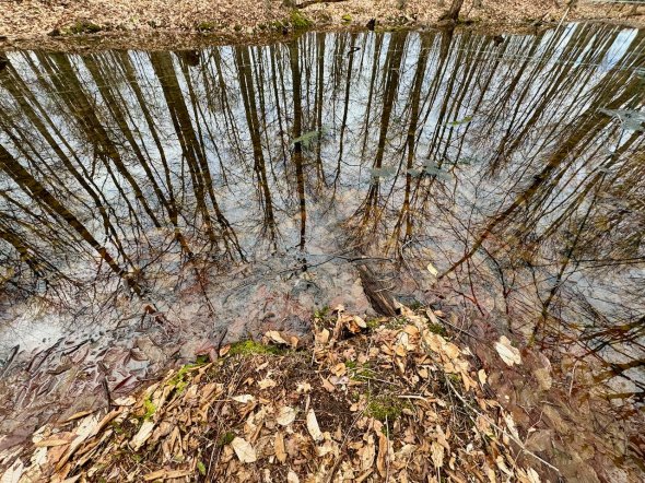
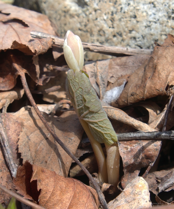
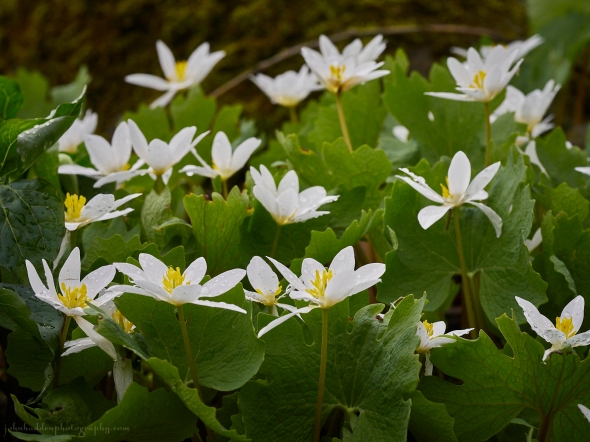 A crop of bloodroot by the Taft Road beaver complex
Morning Observation:
This morning in North Hero at 7:15AM it’s currently 52 degrees under partly sunny skies. Winds are calm. Relative humidity is 98%, dewpoint 52, barometric pressure 29.81”. We picked up 0.01” of rain yesterday and 0.26” so far today during several round of thunderstorms overnight. Yesterday’s high was 59, and yesterday’s low was 43. The overnight low got down to 51.
This morning in Huntington it’s currently 54 degrees under partly cloudy skies. Winds are calm. Relative humidity is 97%, dewpoint 53, barometric pressure 29.84”. We picked up 0.05” of rain yesterday and 0.07” so far today. Yesterday’s high was 66, and yesterday’s low was 44. The overnight low got down to 51.
Forecast Discussion:
Morning sunshine should give way to more clouds later this morning as a weak shortwave trough dips through the region from Canada. Showers and thunderstorms will be most likely over northern Vermont today as highs tick up into the upper 50s and low 60s. High pressure will build in Friday brining some sunshine and warmer temperatures in the upper 60s to low 70s. Low pressure tracking out of the midwest and into the Great Lakes will help transport Gulf of Mexico moisture northeastward over the weekend setting us up for showers later Saturday and into Sunday. High pressure is expected to build back into the region Monday into Tuesday with more active weather expected midweek along with warm temperatures.
3-Day Forecast:
We’ll see partly sunny skies today with a 50% chance of showers and thunderstorms. Highs will be near 65 with south winds 8-11 mph becoming northwesterly in the afternoon. Rainfall amounts of less than 0.10″ are possible with higher amounts possible in thunderstorms. Tonight should be mostly cloudy with a low around 45 and north winds around 6 mph becoming calm after midnight.
Friday should be partly sunny with a high near 66 and south winds 3-5 mph. Friday night should be mostly cloudy with a low around 48 and southeast winds 3-5 mph.
Saturday should be mostly cloudy with a high near 66 and south winds 7-12 mph. Saturday night should be mostly cloudy with a 50% chance of showers. Lows will be around 47 with southeast winds around 9 mph. Rainfall amounts of less than 0.10″ are possible.
Almanac:
Last year on this date in Huntington we had a high of 53 and a low of 35. We picked up 0.23″ of rain.
Last year in North Hero we had a high of 53 and a low of 43. We picked up 0.16″ of rain.
Burlington averages for this date are a low of 43 and a high of 64.
The record low was 27 in 1966.
The record high was 88 in 2018 (we had a high of 86 in Huntington).
The Lake Champlain lake level in Burlington is 97.99′.
The water temperature is 44˚.
Last year’s lake level was at 98.56′.
The Mt. Mansfield snow stake depth is 46″ (4/30).
The average depth for this date is 48″.
Mt. Washington Summit Conditions
Current Temperature: 37˚
Winds are out of the west at 30 gusting to 48 mph
24 hr Precipitation: 0.01″ rain
Visibility: less than 1/16 mile in fog
Sky Notes:
Sunrise: 5:40AM
Sunset: 7:57PM
Length of day: 14:17:09
Today will be 2:37 longer than yesterday.
The Moon is a waning crescent, 23 days old with 41% illumination.
Moonrise: 3:12AM
Moonset: 1:14PM
About Today’s Photo:
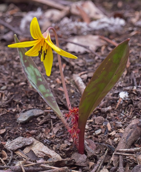
There’s a little knoll in the midst of the now sprawling Taft Road beaver complex that sports a bumper crop of bloodroot this time of year. There are dozens of blossoms blooming.
Panasonic GX8, Olympus 60mm macro lens, ISO 800, f/7.1, 1/800″ exposure
Wednesday, May 1, 2024

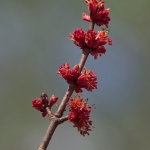
 Cherry blossoms bursting
Rabbit-rabbit!
Morning Observation:
This morning in Huntington at 6:15AM it’s currently 44 degrees under cloudy skies. Winds are calm. Relative humidity is 97%, dewpoint 43, barometric pressure 29.91”. We picked up 0.10” of rain yesterday and 0.05” so far today. Yesterday’s high was 60, and yesterday’s low was 43. The overnight low got down to 44.
This morning in North Hero it’s currently 44 degrees under cloudy skies with fog. Winds are calm. Relative humidity is 99%, dewpoint 44, barometric pressure 29.94”. We picked up 0.12” of rain yesterday and 0.01” far today. Yesterday’s high was 59, and yesterday’s low was 443. The overnight low got down to 43.
Forecast Discussion:
Morning fog is the main weather headline for today with valley fog prevalent in the Champlain Valley. We’ll see mostly cloudy skies today with highs in the upper 50s/low 60s north to around 70 south with some terrain driven sprinkles possible during the day today. A weak upper level trough is expected to drop into the region overnight tonight bringing showers overnight and into Thursday. Drier conditions are expected for Friday as a brief ridge of high pressure slides through with some glimpses of sunshine possible Friday afternoon as highs push into the upper 60s and low 70s. Unsettled conditions are expected heading into the weekend as an occluded front moves through sometime later Saturday night into Sunday.
3-Day Forecast:
We’ll see mostly cloudy skies morning fog today with a 20% chance of showers. Highs will be near 60 with light northwest winds. Tonight should be mostly cloudy with showers likely around daybreak. Lows will be around 49 with calm winds becoming southeasterly around 6 mph after midnight. Chance of precipitation is 60% with rainfall amounts of less than 0.10″ possible.
Thursday should be mostly cloudy with a 50% chance of showers, mainly before 5:0PM. Highs will be near 64 with south winds around 9 mph becoming northwesterly in the afternoon. Rainfall amounts of less than 0.10″ are possible. Thursday night should be mostly cloudy with a low around 46 and north winds around 6 mph becoming calm after midnight.
Friday should be partly sunny with a high near 66 with east winds 3-5 mph. Friday night should be mostly cloudy with a low around 48 and southeast winds 3-5 mph.
Almanac:
Last year on this date in Huntington we had a high of 56 and a low of 37. We picked up 0.91″ of rain.
Last year in North Hero we had a high of 55 and a low of 44. We picked up 0.65″ of rain.
Burlington averages for this date are a low of 42 and a high of 64.
The record low was 25 in 1961.
The record high was 86 in 2001 (we had a high of 84 in Huntington).
The Lake Champlain lake level in Burlington is 98.02′.
The water temperature is 44˚.
Last year’s lake level was at 98.40′.
The Mt. Mansfield snow stake depth is 46″.
The average depth for this date is 48″.
Mt. Washington Summit Conditions
Current Temperature: 38˚
Winds are out of the NW at 24-29 mph
24 hr Precipitation: 0.31″ rain
Visibility: about 1/16 mile in fog
Sky Notes:
Sunrise: 5:42AM
Sunset: 7:56PM
Length of day: 14:14:32
today will be 2:39 longer than yesterday.
The Moon is in its last quarter, 22 days old with 52% illumination.
Moonrise: 2:40AM
Moonset: 11:54AM
About Today’s Photo:
We have a Manchu cherry bush on in our patio garden that is producing a profusion of flowers this year. I’m waiting to see what kind of pollinators come to it as I’ve only seen a random bumble bee or two so far this spring.
Sony A7II, Sony 90mm macro lens, ISO 800, f/10, 1/60″ exposure
Tuesday, April 30, 2024

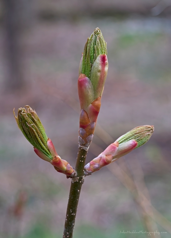 Buckeye buds bursting
Morning Observation:
This morning in Huntington at 7:20AM it’s currently 55 degrees under cloudy skies. Winds are calm. Relative humidity is 68%, dewpoint 45, barometric pressure 29.96”. Yesterday’s high was 59, and yesterday’s low was 42. The overnight low got down to 43.
This morning in North Hero it’s currently 49 degrees under cloudy skies. Winds are calm. Relative humidity is 88%, dewpoint 46, barometric pressure 29.98”. We picked up 0.01” of rain so far today. Yesterday’s high was 53, and yesterday’s low was 43. The overnight low got down to 47.
Forecast Discussion:
Morning radar imagery shows an area of showers over the Montreal area at this hour with a low pressure system spinning over Lake Superior. Spotty showers and possible thunderstorms can be expected during the day today as the low lifts a warm front through the region during the day bumping daytime highs into the mid to upper 50s. The low will then swing a cold front through this afternoon reinvigorating chances for showers and thunderstorms this afternoon and into this evening. Some thunderstorms could contain small hail and heavy rains. Mostly dry and seasonable conditions are expected for Wednesday. A weak shortwave is expected to drop down into the region from Canada Wednesday night into Thursday bringing to some showers, particularly over northern areas. Showers should wind down by Thursday afternoon with brief ridging expected for Friday before more unsettled conditions return for the weekend.
3-Day Forecast:
We’ll see cloudy skies today with a chance of showers before noon, then a chance of showers and thunderstorms between noon and 5:00PM, then showers likely and possibly a thunderstorm after 5:00PM. Some of the storms could produce small hail and heavy rain. Highs will be near 57 with southeast winds 8-11 mph. Chance of precipitation is 60% with rainfall amounts between 0.10″-0.25″ with higher amounts possible in thunderstorms. Tonight should be mostly cloudy with showers and possibly a thunderstorm before 9:00PM, then showers likely. Lows will be around 46 with southeast winds 3-7 mph. Chance of precipitation is 80% with rainfall amounts between 0.10″-0.25″ with higher amounts possible in thunderstorms.
Wednesday should be mostly cloudy with a 30% chance of showers. Highs will be near 59 with north winds around 5 mph becoming calm in the afternoon. Wednesday night should be mostly cloudy with a 30% chance of showers. Lows will be around 47 with calm winds becoming southeasterly around 5 mph after midnight.
Thursday should be partly sunny with a 40% chance of showers. Highs will be near 65 with south winds 7-9 mph becoming northwesterly in the afternoon. Rainfall amounts of less than 0.10″ are possible. Thursday night should be mostly cloudy with a low around 45 and north winds 3-7 mph.
Almanac:
Last year on this date in Huntington we had a high of 54 and a low of 45. We picked up 0.12″ of rain.
Last year in North Hero we had a high of 57 and a low of 45. We picked up 0.08″ of rain.
Burlington averages for this date are a low of 42 and a high of 63.
The record low was 27 in 2012 (we had a low of 24 in Huntington).
The record high was 84 in 2004 (we had a high of 82 in Huntington).
The Lake Champlain lake level in Burlington is 98.12′.
The water temperature is 41˚.
Last year’s lake level was at 98.29′.
The Mt. Mansfield snow stake depth is 47″.
The average depth for this date is 49″.
Mt. Washington Summit Conditions
Current Temperature: 35˚
Winds are out of the west at 24 gusting to 31 mph
24 hr Precipitation: 0
Visibility: around 1/8 mile in fog
Sky Notes:
Sunrise: 5:43AM
Sunset: 7:55PM
Length of day: 14:11:53
Today will be 2:40 longer than yesterday.
The Moon is waning gibbous, 21 days old with 63% illumination.
Moonrise: 2:04AM
Moonset: 10:36AM
About Today’s Photo:
I planted a couple of buckeye trees several years ago, and they’ve flourished. They produce gigantic leaf buds each spring that are opening up right now. I’m always amazed at how much these trees grow each season. The buds above are about 3″ in length and they will push out a good 6″-8″ of new stem this season. If you’re looking for a colorful and fast-growing tree, the buckeye is for you!
Sony A7II, Sony 90mm macro lens, ISO 800, f/8, 1/160″ exposure
Monday, April 29, 2024

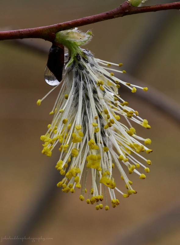 A willow flower with a drop of rain
Morning Observation:
This morning in Huntington at 6:05AM it’s currently 43 degrees under cloudy skies. Winds are calm. Relative humidity is 91%, dewpoint 41, barometric pressure 30.96”. We picked up 0.67” of rain yesterday. Yesterday’s high was 69, and yesterday’s low was 50. The overnight low got down to 43.
This morning in North Hero it’s currently 43 degrees under cloudy skies. Winds are out of the northwest at 2-5 mph. Relative humidity is 88%, dewpoint 40, barometric pressure 30.12”. We picked up 0.71” of rain yesterday. Yesterday’s high was 57, and yesterday’s low was 46. The overnight low got down to 43.
Forecast Discussion:
We’ve got a mostly dry albeit coolish day on tap for today with highs expected to in the mid to upper 50s under mostly cloudy skies. Low pressure approaching the western Great Lakes today will lift a warm front into the region overnight tonight bringing widespread showers later tonight through much of Tuesday. Dry and seasonably mild conditions are expected for the middle part of the week as high pressure settles in Wednesday through Friday. Unsettled and warm conditions look to arrive by the weekend.
3-Day Forecast:
We’ll see mostly cloudy skies today with a high near 57 and north winds 8-10 mph. Tonight should be cloudy with showers likely, mainly after 5:00AM. Lows will be around 44 with calm winds becoming southeasterly around 6 mph after midnight. Chance of precipitation is 60% with rainfall amounts between 0.10″-0.25″ possible.
Tuesday should be cloudy with showers. Highs will be near 63 with southeast winds 7-10 mph. Chance of precipitation is 80% with rainfall amounts between 0.10″-0.25″ possible. Tuesday night should be cloudy with showers likely. Lows will be around 46 with southeast winds 5-7 mph becoming calm after midnight. Chance of precipitation is 70% with rainfall amounts between 0.10″-0.25″ possible.
Wednesday should be mostly cloudy with a 30% chance of morning showers. Highs will be near 61 with calm winds becoming northwesterly around 5 mph in the afternoon. Wednesday night should be mostly cloudy with a low around 47 and calm winds.
Almanac:
Last year on this date in Huntington we had a high of 57 and a low of 46. We picked up 0.07″ of rain.
Last year in North Hero we had a high of 55 and a low of 46. We picked up 0.04″ of rain.
Burlington averages for this date are a low of 42 and a high of 63.
The record low was 26 in 2012 (we had a low of 24 in Huntington).
The record high was 85 in 1986.
The Lake Champlain lake level in Burlington is 98.14′.
The water temperature is 43˚.
Last year’s lake level was at 98.21′.
The Mt. Mansfield snow stake depth is 50″.
The average depth for this date is 51″.
Mt. Washington Summit Conditions
Current Temperature: 36˚
Winds are out of the NW at 50 gusting to 62 mph
24 hr Precipitation: 0.73″ rain
Visibility: around 70 miles under partly cloudy skies.
Sky Notes:
Sunrise: 5:45AM
Sunset: 7:54PM
Length of day: 14:09:12
today will be 2:41 longer than yesterday.
The Moon is waning gibbous, 20 days old with 73% illumination.
Moonrise: 1:18AM
Moonset: 9:24AM
About Today’s Photo:
Willows are exploding everywhere this time of year. I never tire of the beautiful intricacy of the willow flowers—so delicate and so effusive!
Panasonic GX8, olympus 60mm macro lens, ISO 800, f/8, 1/640″ exposure
Sunday, April 28, 2024

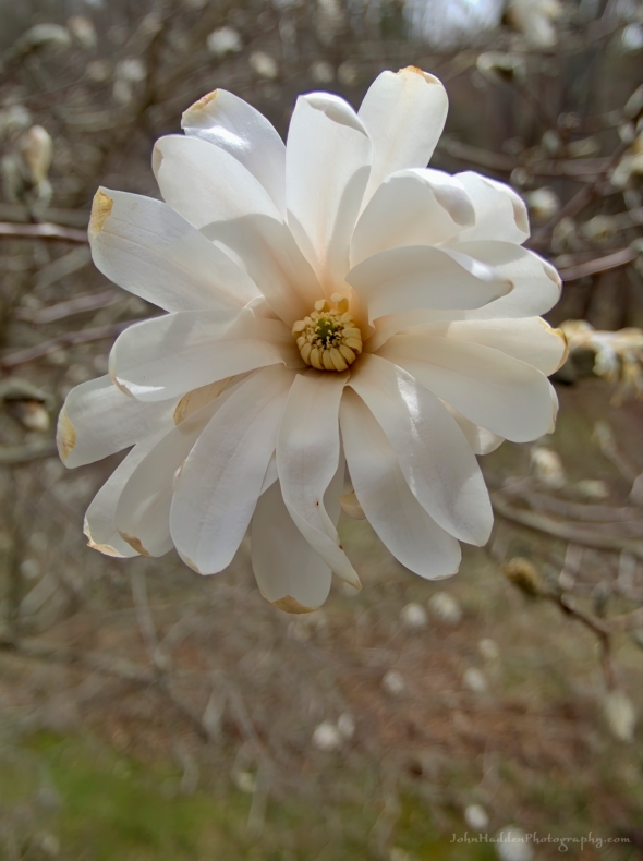 A magnolia blossom by our back deck
Morning Observation:
This morning in Huntington at 7:20AM it’s currently 53 degrees under cloudy skies. Winds are calm. Relative humidity is 79%, dewpoint 46, barometric pressure 30.09”. We picked up 0.01” of rain last night and 0.03” so far today. Yeserday’s high was 68, and yesterday’s low was 31. The overnight low got down to 50.
This morning in North Hero it’s currently 46 degrees and raining under cloudy skies. Winds are out of the south at 14-18 mph. Relative humidity is is 89%, dewpoint 43, barometric pressure 30.08”. We picked up 0.01” of rain last night and 0.21” so far today. Yesterday’s high was 59, ynd yesterday’s low was 39. The overnight low got down to 46.
Forecast Discussion:
Morning radar imagery show an area of showers and thunderstorms over Ottawa at this hour pushing into northern New York and Vermont. Showers and thunderstorms will continue to move into Vermont during the morning hours as gusty south winds bump daytime highs into the upper 60s to near 70 with dewpoints in the 50s and 60s giving us a hint of summer weather. Low pressure currently just south of James Bay will swing a weak cold front across the region this afternoon bringing renewed chances for showers and thunderstorms this afternoon and into this evening. Showers will wind down overnight as high pressure builds in for Monday bringing partly sunny skies with highs around 60. A weak surface low will cross the region Tuesday bringing more showers during the day Tuesday and into Tuesday night. High pressure will build back in on Wednesday with temperatures expected to bump into the 70s Thursday and Friday. Some hit or miss showers and thunderstorms will be possible at the end of the week.
3-Day Forecast:
We’ll see cloudy skies today with morning showers likely, then showers likely and possibly a thunderstorm after 3pm. Highs will be near 69 with southwest winds 9-11 mph in Huntington and 13-22 in the Champlain Valley. Chance of precipitation is 70% with rainfall amounts between 0.10″-0.25″ possible with higher amounts possible in thunderstorms. Tonight should start out cloudy with showers likely and possibly a thunderstorm before 8:0PM, then a chance of showers. Skies should gradually become partly cloudy with a low around 41 and west winds 7-9 mph becoming northerly after midnight. Chance of precipitation is 60% with rainfall amounts between 0.10″-0.25″ possible with higher amounts possible in thunderstorms.
Monday should be partly sunny with a high near 59 and north winds around 8 mph. Monday night should bring increasing clouds with a 30% chance of showers late. Lows will be around 45 with north winds around 5 mph becoming calm in the evening.
Tuesday should be cloudy with showers likely, mainly after 5:00PM. Highs will be near 62 with southeast winds around 8 mph. Chance of precipitation is 60% with rainfall amounts between 0.10″-0.25″ possible. Tuesday night should be cloudy with showers. Lows will be around 48 with southeast winds 3-5 mph. Chance of precipitation is 80% with rainfall amounts between 0.10″-0.25″ possible.
Almanac:
Last year on this date in Huntington we had a high of 69 and a low of 33.
Last year in North Hero we had a high of 66 and a low of 39.
Burlington averages for this date are a low of 41 and a high of 62.
The record low was 24 in 1947.
The record high was 90 in 1990.
The Lake Champlain lake level in Burlington is 98.10′.
The water temperature is 44˚.
Last year’s lake level was at 98.26′.
The Mt. Mansfield snow stake depth is 55″.
The average depth for this date is 52″.
Mt. Washington Summit Conditions
Current Temperature: 44˚
Winds are out of the west at 27-29 mph
24 hr Precipitation: 0.02″ rain
Visibility: about 1/16 mile in fog
Sky Notes:
Sunrise: 5:46AM
Sunset: 7:53PM
Length of day: 14:06:30
Today will be 2:43 longer than yesterday.
The Moon is waning gibbous, 19 days old with 82% illumination.
Moonrise: 12:21AM
Moonset: 8:21AM
About Today’s Photo:
It’s been a rough week for the magnolia off our back deck. Sub freezing overnight lows and frost have bit many of the blossoms, and you can see the tinge of brown along the tips of the petals. Fortunately it’s looking like sub freezing temperature might finally be on their way out.
Panasonic Lumix DS-SZ200, ISO 125, f/3.3, 1/1600″ exposure
Saturday, April 27, 2024

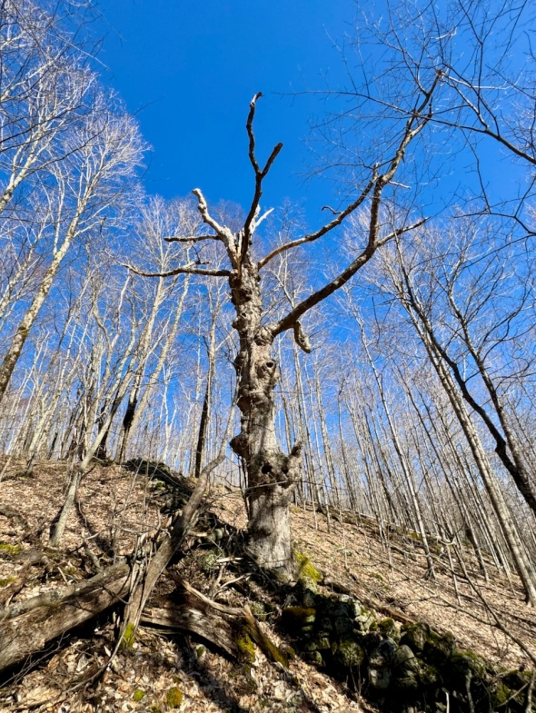 A old “witness tree” in the nearby woods
Morning Observation:
This morning in Huntington at 7:10AM it’s currently 34 degrees under clear skies. Winds are calm. Relative humidity is 90%, dewpoint 31, barometric pressure 30.46”. Yesterday’s high was 59, and yesterday’s low was 24. The overnight low got down to 31.
This morning in North Hero it’s currently 44 degrees under clear skies. Winds are out of the south at 5-7 mph. Relative humidity is 74%, dewpoint 36, barometric pressure 30.45”. Yesterday’s high was 54, and yesterday’s low was 34. The overnight low got down to 39.
Forecast Discussion:
We’ve got another pleasant spring day on tap for today with sunny skies this morning giving way to clouds later in the day. Morning radar imagery shows low pressure approaching the western Great Lakes pushing a warm front ahead of it. This front will lift through the North Country today bumping daytime highs into the low to mid 60s with increasing southerly winds. The low will then push a weakening upper level trough through the region tonight into Sunday bringing widespread rain overnight and into early Sunday with perhaps a rumble of thunder. Showers will become more scattered in nature on Sunday with highs pushing into the upper 60s to low 70s. Dewpoints are expected to rise into the 50s to near 60 as well giving us a taste of summer with some rumbles of thunder possible in the afternoon. Dry and seasonably mild conditions are expected Monday before more unsettled conditions return Tuesday and into the end of next week.
3-Day Forecast:
We’ll see sunny skies today with a high near 63 and south winds 7-15 mph. Tonight should be cloudy with showers likely, mainly after 11:00PM. Lows will be around 46 with south winds 9-13 mph in Huntington and 21-25 mph in the Champlain Valley. Chance of precipitation is 70% with rainfall amounts between 0.10″-0.25″ possible.
Sunday should be mostly cloudy with a 50% chance of showers and afternoon thunderstorms. Highs will be near 68 with south winds around 10 mph in Huntington and 17-25 mph in the Champlain Valley. New rainfall amounts between 0.10″-0.25″ are possible with higher amounts possible in thunderstorms. Sunday night should be cloudy with a 40% chance of showers. Lows will be around 46 with southwest winds 6-8 mph becoming northwesterly after midnight. Rainfall amounts of less than 0.10″ are possible.
Monday should be partly sunny with a high near 63 and north winds 7-10 mph. Monday night should be mostly cloudy with a 40% chance of showers. Lows will be around 46 with north winds around 6 mph becoming light and variable in the evening. Rainfall amounts of less than 0.10″ are possible.
Almanac:
Last year on this date in Huntington we had a high of 59 and a low of 34.
Last year in North Hero we had a high of 55 and a low of 41.
Burlington averages for this date are a low of 41 and a high of 62.
The record low was 22 in 1972.
The record high was 90 in 1990.
The Lake Champlain lake level in Burlington is 98.16′.
The water temperature is 43˚.
Last year’s lake level was at 98.30′.
The Mt. Mansfield snow stake depth is 58″.
The average depth for this date is 53″.
Mt. Washington Summit Conditions
Current Temperature: 27˚
Winds are out of the north at 27-29 mph
24 hr Precipitation: 0
Visibility: around 80 miles under clear skies.
Sky Notes:
Sunrise: 5:48AM
Sunset: 7:51PM
Length of day: 14:03:47
Today will be 2:44 longer than yesterday.
The Moon is waning gibbous, 18 days old with 89% illumination.
No Moonrise
Moonset: 7:30AM
About Today’s Photo:
There’s an old maple “witness tree” in the woods along a trail that I often take for my morning runs. I’ve said “good morning” to it for decades and taken photos and watched it slowly disassemble as the years go by. The term “witness tree” comes from the old practice of saving certain trees to bear witness to property lines. Note the tumbledown stone fence that the tree is part of.
iPhone 15 Pro
Friday, April 26, 2024

 Ostrich fern heads pushing out of the ground
Morning Observation:
This morning in Huntington at 8:00AM it’s currently 38 degrees under clear skies. Winds are calm. Relative humidity is 76%, dewpoint 31, barometric pressure 30.52”. Yesterday’s high was 50, and yesterday’s low was 19. The overnight low got down to 24.
This morning in North Hero it’s currently 39 degrees under clear skies. Winds are out of the south at 4-6 mph. Relative humidity is 80%, dewpoint 33, barometric pressure 30.52”. Yesterday’s high was 44, and yesterday’s low was 28. The overnight low got down to 34.
Forecast Discussion:
Clear skies and warming temperatures are on tap for today courtesy of high pressure. Highs today should top out in the mid to upper 50s. Saturday’s looking mostly sunny with increasing south winds as high pressure begins to slide to our east and a southerly airflow picks up. Highs tomorrow will be in the low to mid 60s. Clouds will be on the increase later Saturday afternoon out ahead of a weakening shortwave trough which will bring scattered showers overnight Saturday into Sunday with some rumbles of thunder possible Saturday night. Showers are expected to become more scattered in nature Sunday as highs push into the mid to upper 60s. With dewpoints in 50s, it will feel a bit more humid and we might hear rumble of thunder as well. Dry and cloudy conditions are expected for Monday with highs pushing 70 west of the Greens and upper 50s east. Another round of showers is expected on Tuesday as a cold front swings through.
3-Day Forecast:
We’ll see sunny skies today with a high near 56 and light south winds. Tonight should be clear with a low around 35 and south winds 5-8 mph.
Saturday should be sunny with a high near 63 and south winds 5-11 mph. Saturday night should bring increasing clouds with showers likely, mainly after 1:00AM. Lows will be around 43 with south winds 9-13 mph in Huntington and 15-20 mph over Lake Champlain. Chance of precipitation is 60% with rainfall amounts of less than 0.10″ possible.
Sunday should be mostly cloudy with morning showers likely. Highs will be near 66 with south winds 9-15 mph. Chance of precipitation is 60% with rainfall amounts of less than 0.10″ possible. Sunday night should be mostly cloudy with a 30% chance of showers. Lows will be around 50 with west winds around 6 mph becoming northerly after midnight.
Almanac:
Last year on this date in Huntington we had a high of 57 and a low of 30. We picked up 0.03″ of rain.
Last year in North Hero we had a high of 55 and a low of 36. We picked up 0.16″ of rain.
Burlington averages for this date are a low of 40 and a high of 61.
The record low was 22 in 1972.
The record high was 80 in 1990.
The Lake Champlain lake level in Burlington is 98.28′.
The water temperature is 41˚.
Last year’s lake level was at 98.34′.
The Mt. Mansfield snow stake depth is 60″.
The average depth for this date is 54″.
Mt. Washington Summit Conditions
Current Temperature: 15˚
Winds are out of the north at 22-28 mph.
24 hr Precipitation: 0
Visibility: around 100 miles under clear skies.
Sky Notes:
Sunrise: 5:49AM
Sunset: 7:50PM
Length of day: 14:01:03
Today will be 2:45 longer than yesterday.
The Moon is waning gibbous, 17 days old with 94% illumination.
Moonrise: 11:15PM
Moonset: 6:51AM
About Today’s Photo:
Ostrich ferns are beginning to push their fuzzy heads out of the ground in several spots around our property. I’m always struck by the utter furriness of these things as they emerge.
iPhone 15 Pro
Wednesday, April 24, 2024

 Early spring colors in Huntington Center
Morning Observation:
This morning in Huntington at 7:30AM it’s currently a balmy 50 degrees under cloudy skies. Winds are calm. Relative humidity is 69%, dewpoint 40, barometric pressure 29.72”. Yesterday’s high was 69, and yesterday’s low was 31. The overnight low got down to 50.
This morning in North Hero it’s currently 45 degrees and raining lightly under overcast skies. Winds are calm. Relative humidity is 91%, dewpoint 43, barometric pressure 29.72”. We picked up 0.11” of rain so far today. Yesterday’s high was 61, and yesterday’s low was 41. The overnight low got down to 45.
Forecast Discussion:
Morning radar imagery shows a trough of low pressure stretching along the St. Lawrence river with a line of shower extending along it. These showers are making their way into Vermont at this hour. Daytime highs are expected to top out this morning and drop through the day as a sharp cold front swings through changing rain over to snow showers by this afternoon. Not much accumulation is expected given the warm antecedent temperatures—maybe a dusting above 1000′ with perhaps an inch over higher mountain summits. Precipitation is expected to come to an end quickly later this evening with skies clearing as cool high pressure moves in. Dry conditions will round out the week with highs on Thursday in the mid 40s and in the upper 50s to near 60 on Friday under sunny skies. Most of Saturday is looking dry at this point with a chance of showers arriving Saturday night and into Sunday as a series of weak troughs swing through. Temperatures are expected to be on the increase through the weekend with highs in the low 60s Saturday, mid 60s on Sunday, and pushing 70 on Monday.
3-Day Forecast:
We’ll see cloudy skies today with rain showers before 5:00PM, then a slight chance of rain and snow showers. Temperature will top out around 50 this morning and fall to around 36 by 5:00PM. Winds will be southwesterly 7-13 mph becoming northerly in the afternoon. Chance of precipitation is 100% with little or no snow accumulation expected. Tonight should start out mostly cloudy then gradually become clear with a low around 23 and north winds 7-13 mph.
Thursday should be sunny and cool with a high near 46 and northwest winds 7-9 mph. Thursday night should be clear with a low around 26 and north winds around 5 mph becoming calm in the evening.
Friday should be sunny with a high near 57 and calm winds becoming westerly around 5 mph in the afternoon. Friday night should be mostly clear with a low around 33 and light and variable winds becoming southeasterly around 5 mph after midnight.
Almanac:
Last year on this date in Huntington we had a high of 47 and a low of 41. We picked up 0.36″ of rain.
Last year in North Hero we had a high of 49 and a low of 42. We picked up 0.15″ of rain.
Burlington averages for this date are a low of 40 and a high of 60.
The record low was 25 in 1993.
The record high was 82 in 1942.
The Lake Champlain lake level in Burlington is 98.42′.
The water temperature is 44˚.
Last year’s lake level was at 98.25′.
The Mt. Mansfield snow stake depth is 59″.
The average depth for this date is 56″.
Mt. Washington Summit Conditions
Current Temperature: 29˚
Winds are out of the west at 35 gusting to 45 mph
24 hr Precipitation: 0
Visibility: less than 1/16 mile in freezing fog
Sky Notes:
Sunrise: 5:52AM
Sunset: 7:48PM
Length of day: 13:55:30
Today will be 2:47 longer than yesterday.
The Moon is waning gibbous, 15 days old with 99% illumination.
Moonrise: 8:55PM
Moonset: 5:56AM
About Today’s Photo:
I love the subtle colors of this time of year with the reds and pinks of maple blossoms blushing the hillsides and the grass just beginning to green. In this view from Huntington Center, Bald hill rises to the left with Little Baldy to the right and Camel’s Hump in the center.
Tuesday, April 23, 2024

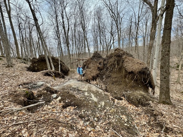 Huge blowdowns in the woods above Defrate Road
Morning Observation:
This morning in Huntington at 6:50AM it’s currently 32 degrees under clear skies. Winds are calm. Relative humidity is 82%, dewpoint 27, barometric pressure 30.09”. Yesterday’s high was 50, and yesterday’s low was 30. The overnight low got down to 31.
This morning in North Hero it’s currently 43 degrees under clear skies. Winds are out of the south at 12-15 mph. Relative humidity is is 69%, dewpoint 33, barometric pressure 30.06”. Yesterday’s high was 48, and yesterday’s low was 31. The overnight low got down to 41.
Forecast Discussion:
We’ve got a lovely albeit breezy day on tap for today courtesy of high pressure which is currently sliding to our east allowing for a southerly airflow to push warmer air into the region. Highs today will top out in the upper 50s to low 60s with gusty south winds. Clouds will be on the increase this afternoon out ahead of our next storm system. Low pressure tracking to our north tonight will drag a potent and quick-moving upper level trough across the region bringing widespread rain overnight tonight and into Wednesday. A sharp trailing cold front will drop temperatures through the day Wednesday changing the rain over to snow with some light accumulations expected. The northern ‘Dacks and summits of the northern Greens may pick up an inch or two of wet snow, with just a soggy dusting likely at lower elevations. High pressure will move back in behind the departing front with dry conditions expected to wrap up the work week. Thursday will be cool—in the upper 40s—with highs on Friday approaching 60. Unsettled and increasingly warm conditions are expected for the weekend as series of shortwave troughs slide through the region bringing showers Saturday and Sunday.
3-Day Forecast:
We’ll see mostly sunny skies today with a high near 63 and south winds 8-16 mph in Huntington and 16-21 mph in the Champlain Valley. Tonight should be cloudy with rain likely, mainly after 3:0AM. Lows will be around 46 with south winds 10-18 mph. Chance of precipitation is 60% with rainfall amounts of less than 0.10″ possible.
Wednesday should be cloudy with rain before 1:00PM, mixing and changing over to snow after 3:00PM. Highs will top out near 47 by 9:00AM, then fall to around 33 during the remainder of the day. Winds will be out of the south at 8-16 mph becoming northerly in the afternoon. Chance of precipitation is 100% with snow accumulation of less than 0.50″ possible. Wednesday night should be mostly clear with a low around 23 and northwest winds 8-13 mph.
Thursday should be sunny with a high near 48 and northwest winds around 7 mph. Thursday night should be clear with a low around 29 and north winds around 5 mph becoming calm in the evening.
Almanac:
Last year on this date in Huntington we had a high of 50 and a low of 43. We picked up 2.10″ of rain (!)
Last year in North Hero we had a high of 52 and a low of 43. We picked up 0.72″ of rain.
Burlington averages for this date are a low of 39 and a high of 60.
The record low was 24 in 1994.
The record high was 82 in 2007 (we had a high of 81 in Huntington).
The Lake Champlain lake level in Burlington is 98.48′.
The water temperature is 42˚.
Last year’s lake level was at 98.11′.
The Mt. Mansfield snow stake depth is 62″ (4/22).
The average depth for this date is 56″.
Mt. Washington Summit Conditions
Current Temperature: 22˚
Winds are out of the west at 27-28 mph
24 hr Precipitation: 0.4″ snow, 0.04″ melted precipitation
Visibility: around 100 miles under clear skies.
Sky Notes:
Sunrise: 5:54AM
Sunset: 7:46PM
Length of day: 13:52:42
today will be 2:48 longer than yesterday.
The Moon is the full “Pink” moon (Northeast Native American), 14 days old with 100% illumination.
Moonrise: 7:47PM
Moonset: 5:37AM
About Today’s Photo:
We came across some humungous blowdowns up in the woods above Delfrate Road the other day. Robin gives a sense of scale to the towering root ball of the maple that was toppled in the wind storms back in January. The shallow root system clinging to the rock were no match for the fierce downsloping winds we encountered then.
iPhone 15 Pro
Monday, April 22, 2024

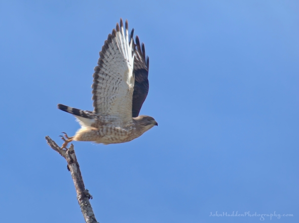 A broad-winged hawk takes flight
Morning Observation:
This morning in Huntington at 7:15AM it’s currently 30 degrees under mostly clear skies. Winds are calm. Relative humidity is 71%, dewpoint 22, barometric pressure 30.03”. We picked up a dusting of snow overnight. Yesterday’s high was 47, and yesterday’s low was 29. The overnight low got down to 30.
This morning in North Hero it’s currently 38 degrees under mostly clear skies. Winds are calm. Relative humidity is 62%, dewpoint 26, barometric pressure 30.08”. Yesterday’s high was 50, and yesterday’s low was 38. The overnight low got down to 31.
Forecast Discussion:
High pressure cresting over the region today will bring very dry albeit chilly conditions to the North Country with highs today only in the mid 40s to near 50 with gusty northwest winds. The high is expected to move to our east on Tuesday, setting up a southerly airflow which will allow temperatures to rebound into the low 60s. Clouds will be on the increase Tuesday afternoon out ahead of our next weather-maker. A strong upper level trough is expected to drop down from Canada later Tuesday night into Wednesday bringing widespread rain to the region overnight Tuesday and through Wednesday. Highs on Wednesday will top out in the upper 40s early in the day, then drop in the afternoon as a potent trailing cold front swings through behind the trough changing rain to snow in the afternoon and evening. Some light snow accumulations should be expected before precipitation winds down Wednesday night. Dry and chilly Canadian high pressure will build in for latter part of the week with highs on Thursday only in the mid 40s, warming to more seasonable levels Friday, with highs on Saturday expected to be in the low 60s.
3-Day Forecast:
We’ll see sunny skies today with a high near 47 and northwest winds 10-15 mph. Tonight should be clear with a low around 31 and south winds 3-8 mph increasing to 12-17 mph in the Champlain Valley.
Tuesday should bring increasing clouds with a high near 61 and south winds 13-16 mph in Huntington and 22-26 mph in the Champlain Valley. Tuesday night should be cloudy with rain, mainly after 11:00PM. Lows will be around 44 with south winds 10-15 mph. Chance of precipitation is 80% with rainfall amounts between 0.10″-0.25″ possible.
Wednesday should be cloudy with rain before 2:00PM, then rain and snow showers likely. Highs will be near 47 with south winds 8-16 mph becoming northwesterly in the afternoon. Chance of precipitation is 100% with new snow accumulations of less than 0.50″ possible. Wednesday night should be partly cloudy with a 30% chance of rain and snow showers before 7:00PM. Lows will be around 24 with northwest winds 10-15 mph.
Almanac:
Last year on this date in Huntington we had a high of 62 and a low of 45.
Last year in North Hero we had a high of 57 and a low of 46. We picked up 0.01″ of rain.
Burlington averages for this date are a low of 39 and a high of 56.
The record low was 21 in 1947.
The record high was 80 in 1973.
The Lake Champlain lake level in Burlington is 98.60′.
The water temperature is 43˚.
Last year’s lake level was at 98.06′.
The Mt. Mansfield snow stake depth is 60″.
The average depth for this date is 59″.
Mt. Washington Summit Conditions
Current Temperature: 5˚
Winds are out of the NW at 66-70 mph
24 hr Precipitation: 0.4″ snow, 0.03″ melted precipitation
Visibility: around 100 miles under partly cloudy skies.
Sky Notes:
Sunrise: 5:54AM
Sunset: 7:46PM
Length of day: 13:52:42
Today will be 2:48 longer than yesterday.
The Moon is waxing gibbous, 13. days old with 97% illumination.
Moonrise: 6:41PM
Moonset: 5:19AM
About Today’s Photo:
I saw this broad-winged hawk perched an a dead birch along East Street the other day as I was driving by. I managed to get my camera out just in time before it flew off in a blur of motion.
Panasonic Lumix DS-SZ200, ISO 125, f/8, 1/130″ exposure
Sunday, April 21, 2024

 A calm vernal pool in the East Street woods
Morning Observation:
This morning in Huntington at 7:55AM it’s currently 35 degrees under partly cloudy skies. Winds are calm. Relative humidity is 93%, dewpoint 33, barometric pressure 29.96”. We picked up 0.01” of rain yesterday. Yesterday’s high was 58, and yesterday’s low was 34. The overnight low got down to 29.
This morning in North Hero it’s currently 41 degrees under partly cloudy skies. Winds are out of the southwest at 3-5 mph. Relative humidity is is 70%, dewpoint 32, barometric pressure 29.97”. We picked up 0.02” of rain yesterday. Yesterday’s high was 53, and yesterday’s low was 41. The overnight low got down to 38.
Forecast Discussion:
We’ve got a bit of a roller-coaster ahead of us for the coming week. A ridge of high pressure will bring dry and seasonably cool conditions today through most of Monday. A cold front is expected to cross the region tonight with little fanfare, but much cooler conditions are expected for Monday with highs only in the mid 40s to around 50. Winds are expected to turn into the south on Tuesday allowing warmer air to move with highs expected to bump into the upper 50s to low 60s. Our next storm system arrives later Tuesday night. Temperatures are expected to drop back into the 40s Wednesday with rain likely. Below freezing temperatures Wednesday night will likely bring some wet snow overnight with some moderate accumulations possible over higher elevations. Dry but chilly conditions return Thursday as high pressure builds back in to finish out the week with temperature slowly recovering to more seasonable levels.
3-Day Forecast:
We’ll see mostly sunny skies today with a high near 50 and west winds 6-11 mph. Tonight should be partly cloudy with a slight chance of rain and snow showers. Lows will be around 28 with west winds 9-11 mph.
Monday should be sunny with a high near 45 and northwest winds around 10 mph. Monday night should be clear with a low around 31 and south winds 3-8 mph.
Tuesday should be mostly sunny with a high near 61 and south winds 10-14 mph. Tuesday night should be mostly cloudy with showers likely mainly after 3:00AM. Lows will be around 42 with south winds 11-13 mph. Chance of precipitation is 70% with rainfall amounts of less than 0.10″ possible.
Almanac:
Last year on this date in Huntington we had a high of 76 and a low of 36.
Last year in North Hero we had a high of 61 and a low of 40.
Burlington averages for this date are a low of 38 and a high of 58.
The record low was 23 in 1981.
The record high was 83 in 1987.
The Lake Champlain lake level in Burlington is 98.63′.
The water temperature is 42˚.
Last year’s lake level was at 98.05′.
The Mt. Mansfield snow stake depth is 60″.
The average depth for this date is 62″.
Mt. Washington Summit Conditions
Current Temperature: 17˚
Winds are out of the west at 26-28 mph
24 hr Precipitation: 1.5″ snow and 0.26″ melted precipitation
Visibility: about 1/16 mile in freezing fog
Sky Notes:
Sunrise: 5:57AM
Sunset: 7:44PM
Length of day: 13:47:03
Today will be 2:51 longer than yesterday.
The Moon is waxing gibbous, 12.3 days old with 93% illumination.
Moonrise: 5:34PM
Moonset: 5:00AM
About Today’s Photo:
There’s a persistent vernal pool at the top of the East Street woods hill that’s a reliable place to find critters this time of year. We didn’t see anything moving the other day, but you can clearly see some wood frog eggs on the surface.
iPhone 15 Pro
Saturday, April 20, 2024
 Spring beauties in bloom
Morning Observation:
This morning in Huntington at 7:00AM it’s currently 48 degrees and raining lightly under overcast skies. Winds are calm. Relative humidity is 90%, dewpoint 45, barometric pressure 29.89”. We picked up 0.01” of rain yesterday and 0.01” so far today. Yesterday’s high was 58, and yesterday’s low was 41. The overnight low got down to 46.
This morning in North Hero it’s currently 47 degrees under cloudy skies. Winds are calm. Relative humidity is 56%, dewpoint 32, barometric pressure 29.92”. Yesterday’s high was 54, and yesterday’s low was 44. The overnight low got down to 46.
Forecast Discussion:
A frontal boundary is currently moving through the region with attendant showers stretched along it. Showers should wind down by midmorning, however a fairly robust upper level trough is expected to swing through the region later this afternoon bringing renewed showers and maybe even a bit of graupel or hail, with the best chances for precipitation along the international border. Most of Sunday looks to be dry and seasonably cool, but a strong cold front is expected to swing through Sunday evening bringing scattered showers overnight with some higher elevation snow showers possible. Monday’s looking dry but chilly with highs only in the low to mid 40s. Temperatures are expected to rebound on Tuesday with highs pushing into the upper 50s and low 60s under partly sunny skies. Another storm system is expected to impact the region later Tuesday night into Wednesday.
3-Day Forecast:
We’ll see mostly cloudy skies today with a chance of morning showers, then a chance of showers after 3:00PM. Highs will be near 53 with west winds 5-13 mph. Chance of precipitation is 30% with rainfall amounts of less than 0.10″ possible. Tonight should start out mostly cloudy with a 30% chance of showers, mainly before 9:00PM. Skies should gradually become mostly clear with a low around 32 and west winds 6-11 mph.
Sunday should be mostly sunny with a high near 51 and southwest winds 6-11 mph. Sunday night should be partly cloudy with a 30% chance of snow showers. Lows will be around 27 with west winds around 10 mph. New snow accumulations of less than 0.50″ are possible.
Monday should be sunny and cool with a high near 42 and northwest winds 10-14 mph. Monday night should be mostly clear with a low around 29 and light and variable winds becoming southerly 5- mph after midnight.
Almanac:
Last year on this date in Huntington we had a high of 58 and a low of 34.
Last year in North Hero we had a high of 51 and a low of 36.
Burlington averages for this date are a low of 38 and a high of 56.
The record low was 19 in 1969.
The record high was 88 in 1941.
The Lake Champlain lake level in Burlington is 98.66′.
The water temperature is 43˚.
Last year’s lake level was at 98.17′.
The Mt. Mansfield snow stake depth is 62″ (4/18)
The average depth for this date is 62″.
Mt. Washington Summit Conditions
Current Temperature: 28˚
Winds are out of the west at 44-48 mph
24 hr Precipitation: 0.01″ melted precipitation
Visibility: less than 1/16 mile in freezing fog
Sky Notes:
Sunrise: 5:59AM
Sunset: 7:43PM
Length of day: 13:44:12
Today will be 2:51 longer than yesterday.
The Moon is waxing gibbous, 11.4 days old with 88% illumination.
Moonrise: 4:34PM
Moonset: 4:48AM
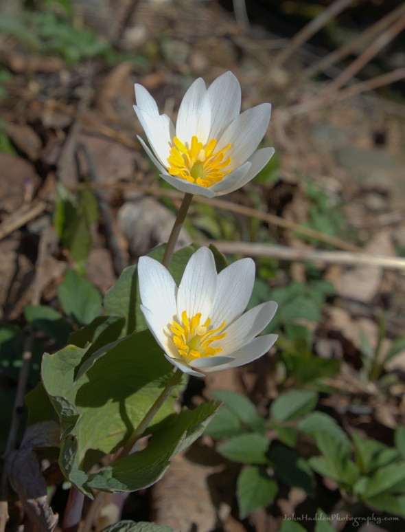
About Today’s Photo:
Carolina spring beauties are one of our earliest spring ephemerals, and indeed I’ve been seeing them in the woods since April 11th. This native plant has a broad range from Alabama in the south up into Newfoundland in the north. There are several spots in the woods nearby our house in Huntington that are carpeted with the lovely blossoms this time of year.
Panasonic GX8, Olympus 60mm macro lens, ISO 1600, f/16, 1/160″ exposure
Friday, April 19, 2024

 A pair of hepatica blossoms nestled in some ramps
Morning Observation:
This morning in Huntington at 7:55AM it’s currently 44 degrees under cloudy skies. Winds are calm. Relative humidity is 85%, dewpoint 40, barometric pressure 30.10”. We picked up 0.19” of rain yesterday and 0.01” so far today. Yesterday’s high was 52, and yesterday’s low was 41. The overnight low got down to 41.
This morning in North Hero it’s currently 45 degrees under cloudy skies. Winds are out of the south at 12-14 mph. Relative humidity is 85%, dewpoint 41, barometric pressure 30.09”. We picked up 0.29” of rain yesterday. Yesterday’s high was 48, and yesterday’s low was 41. The overnight low got down to 44.
Forecast Discussion:
Unsettled conditions will continue today and into Saturday. Morning radar imagery shows low pressure north of the Great Lakes and a secondary low just about over western Lake Erie with showers pushing eastward. After a dry start to the day, chances for showers will be on the increase midday into this afternoon as a cold front crosses the region. Highs today are expected to climb into the mid 50s to low 60s with gusty south winds. A shortwave trough will swing through to our north on Saturday bringing additional chances for scattered showers, most likely along the international border. Drier air will move in for Sunday with partly sunny skies and highs in the low 50s expected. Temperatures will do a bit of a roller-coaster next week with highs on Monday only in the 40s, then bumping into the upper 50s to low 60s on Tuesday. A strong cold front is expected to move through Tuesday night into Wednesday bringing showers and dropping daytime highs back into the 40s Thursday. Warmer air returns later in the week.
3-Day Forecast:
We’ll see mostly cloudy skies today with a 20% chance of afternoon showers. Highs will be near 58 with south winds 9-14 mph in Huntington and 20-24 mph in the Champlain Valley. Tonight should be mostly cloudy with a 40% chance of showers. Lows will be around 42 with south winds 8-18 mph gusting to 28 mph. Raifnall amounts of less than 0.10″ are possible.
Saturday should be partly sunny with a 20% chance of afternoon showers. Highs will be near 52 with west winds 7-14 mph. Saturday night should be partly cloudy with a low around 33 and west winds 6-9 mph.
Sunday should be mostly sunny with a high near 52 and west winds 7-14 mph. Sunday night should be partly cloudy with a low around 31 and southwest winds around 14 mph.
Almanac:
Last year on this date in Huntington we had a high of 44 and a low of 34. We picked up 0.01″ of rain.
Last year in North Hero we had a high of 46 and a low of 37.
Burlington averages for this date are a low of 37 and a high of 57.
The record low was 23 in 1961.
The record high was 91 in 1976.
The Lake Champlain lake level in Burlington is 98.70′.
The water temperature is 41˚.
Last year’s lake level was at 98.20′.
The Mt. Mansfield snow stake depth is 62″.
The average depth for this date is 62″.
Mt. Washington Summit Conditions
Current Temperature: 31˚
Winds are out of the SW at 13-16 mph
24 hr Precipitation: 0.1″ snow, 0.04″ melted precipitation
Visibility: about 1/16 mile in freezing fog
Sky Notes:
Sunrise: 6:00AM
Sunset: 7:42PM
Length of day: 13:41:20
Today will be 2:52 longer than yesterday.
The Moon is waxing gibbous, 10.5 days old with 81% illumination.
Moonrise: 3:32PM
Moonset: 4:31AM
About Today’s Photo:
On our walk the other day, we came across a few hepatica on the hillside. These look like the sharp-lobed variety as the fuzzy leaves seem to have a defined point to them. You’ll find hepatica colored white like these, but we also found some blush-pink blossoms as well. Note the broad green leaves of ramps around the flowers.
Panasonic GX8, Olympus 60mm macro lens, ISO 800, f/16, 1/160″ exposure
Thursday, April 18, 2024

 A solo trout lily in bloom
Morning Observation:
This morning in Huntington at 7:10AM it’s currently 47 degrees under cloudy skies. Winds are calm. Relative humidity is 68%, dewpoint 37, barometric pressure 30.095”. Yesterday’s high was 56, and yesterday’s low was 28. The overnight low got down to 45.
This morning in North Hero it’s currently 47 degrees under cloudy skies. Winds are out of the Relative humidity is 75%, dewpoint 40, barometric pressure 30.04”. Yesterday’s high was 51, and yesterday’s low was 35. The overnight low got down to 41.
Forecast Discussion:
Unsettled conditions will be the rule today and heading into the upcoming weekend. Morning radar imagery shows low pressure over the northern Great Lakes with an occluded front pushing eastward over about Lake Ontario at this hour. A fairly well-defined band of showers extend along this frontal boundary and showers are expected to push into the Champlain Valley by midmorning and into the rest of Vermont by early afternoon. Highs today will be in the upper 40s to around 50 with gusty south winds. Showers are expected to taper off this evening, but a cold front is expected to push through the region later Friday night into Saturday bringing more showers. Another shortwave trough will swing through the region Saturday bringing a slight chance of showers, most likely over northern regions. High pressure is expected to build in on Sunday with dry and seasonable conditions expected into early next week.
3-Day Forecast:
We’ll see cloudy skies today with showers likely, mainly after 11:00AM. Highs will be near 47 with south winds 10-15 mph gusting to 37 mph. Chance of precipitation is 100% with rainfall amounts between 0.10″-0.25″ possible. Tonight should be mostly cloudy with showers likely, mainly before 7:00PM. Lows will be around 39 with southeast winds 7-9 mph in Huntington and 16-20 mph in the Champlain Valley. Chance of precipitation is 60% with rainfall amounts of less than 0.10″ possible.
Friday should be cloudy with a 30 percent chance of afternoon showers. Highs will be near 58 with south winds 9-15 mph in Huntington and 18-25 in the Champlain Valley. Rainfall amounts of less than 0.10″ are possible. Friday night should be cloudy with showers likely, mainly before 8:00PM. Lows will be around 42 with south winds 9-17 mph. Chance of precipitation is 60% with rainfall amounts of less than 0.10″ possible.
Saturday should be partly sunny with a high near 53 and west winds 9-16 mph. Saturday night should be mostly cloudy with a low around 34 and west winds 7-14 mph.
Almanac:
Last year on this date in Huntington we had a high of 49 and a low of 38. We picked up 0.22″ of rain.
Last year in North Hero we had a high of 47 and a low of 41. We picked up 0.16″ of rain.
Burlington averages for this date are a low of 37 and a high of 57.
The record low was 21 in 1948.
The record high was 91 in 1976.
The Lake Champlain lake level in Burlington is 98.72′.
The water temperature is 41˚.
Last year’s lake level was at 98.21′.
The Mt. Mansfield snow stake depth is 64″ (4/16).
The average depth for this date is 64″.
Mt. Washington Summit Conditions
Current Temperature: 31˚
Winds are out of the SE at 6-8 mph
24 hr Precipitation: 0
Visibility: around 90 miles under partly cloudy skies.
Sky Notes:
Sunrise: 6:02AM
Sunset: 7:40PM
Length of day: 13:38:27
Today will be 2:53 longer than yesterday.
The Moon is waxing gibbous, 9.6 days old with 73% illumination.
Moonrise: 2:29PM
Moonset: 4:12AM
About Today’s Photo:
Robin & I went on a wildflower quest yesterday afternoon in the East Street Woods above our house. Though it’s a tad on the early side to find many flowers, we were pleasantly surprised finding many spring beauties, a profusion of ramps, a couple of hepatica, and this solo trout lily which eagle-eye Robin spotted for the win! I hadn’t expected to see any lilies in bloom yet though there were countless lily leaves pushing up through the leaf litter. Note the collection of maple flowers stuck between the stem and leaves of the flower.
Panasonic GX8, Olympus 60mm macro lens, ISO 800, f/8, 1/200″ exposure
Wednesday, April 17, 2024

 Bloodroot in bloom along Fargo Brook
Morning Observation:
This morning in Huntington at 7:15AM it’s currently a frosty 29 degrees under clear skies. Winds are calm. Relative humidity is 96%, dewpoint 28, barometric pressure 30.26”. Yesterday’s high was 59, and yesterday’s low was 33. The overnight low got down to 28.
This morning in North Hero it’s currently 43 degrees under clear skies. Winds are calm. Relative humidity is 66%, dewpoint 32, barometric pressure 30.30”. Yesterday’s high was 59, and yesterday’s low was 38. The overnight low got down to 35.
Forecast Discussion:
We’ve got a pleasant and seasonably warm day on tap for today courtesy of high pressure cresting over the region. We’ll see mostly sunny skies with highs again in the upper 50s to around 60. High, thin cirrus clouds will be on the increase this afternoon out ahead of our next weather-maker. Morning radar imagery shows low pressure making its way in to the western Great Lakes at this hour. The low is expected to lift a warm front into the North Country later tonight bringing the chance for some shower to northern New York overnight and pushing into Vermont by midday Thursday. Showers are expected to be light and scattered in nature. A decaying occluded front is expected to move through the region Thursday night bringing more widespread rain, though precipitation amounts are expected to be light. Unsettled conditions will continue through Friday and into the weekend as a cold front swings through Friday night into Saturday morning. Drier weather returns Sunday into next week as high pressure builds back in.
3-Day Forecast:
We’ll see mostly sunny skies today with a high near 57 and north winds 5-7 mph. Tonight should be mostly cloudy with a 20% chance of showers after 2:00AM. Lows will be around 41 with southeast winds 8-13 mph in the evening.
Thursday should be mostly cloudy with showers likely, mainly between 1:00PM-5:00PM. Highs will be near 51 with south winds 13-16 mph. Chance of precipitation is 70% with rainfall amounts of less than 0.10″ possible. Thursday night should be mostly cloudy with a 30% chance of showers before 8:00PM. Lows will be around 42 with south winds 9-15 mph. Rainfall amounts of less than 0.10″ are possible.
Friday should be mostly cloudy with showers likely after 2:00PM. Highs will be near 58 with south winds 9-14 mph in Huntington and 18-22 in the Champlain Valley. Chance of precipitation is 60% with rainfall amounts of less than 0.10″ possible. Friday night should be mostly cloudy with showers likely, mainly before 2:00PM. Lows will be around 42 with south winds 10-20 mph. Chance of precipitation is 60% with rainfall amounts of less than 0.10″ possible.
Almanac:
Last year on this date in Huntington we had a high of 63 and a low of 44. We picked up 0.67″ of rain.
Last year in North Hero we had a high of 60 and a low of 44. We picked up 1.32″ of rain.
Burlington averages for this date are a low of 37 and a high of 56.
The record low was 13 in 1971.
The record high was 90 in 2002 (we had a high of 89 in Huntington).
The Lake Champlain lake level in Burlington is 98.80′.
The water temperature is 41˚.
Last year’s lake level was at 98.15′.
The Mt. Mansfield snow stake depth is 64″.
The average depth for this date is 64″.
Mt. Washington Summit Conditions
Current Temperature: 21˚
Winds are out of the NW at 33-35 mph
24 hr Precipitation: 0
Visibility: about 90 miles under cloudy skies.
Sky Notes:
Sunrise: 6:04AM
Sunset: 7:39PM
Length of day: 13:35:34
Today will be 2:54 longer than yesterday.
The Moon is waxing gibbous, 8.7 days old with 64% illumination.
Moonrise: 11:23PM
Moonset: 3:49AM
About Today’s Photo:
The patch of bloodroot that I’ve been keeping my eye on down along Fargo Brook is finally in bloom! Yesterday’s warm sunshine convinced the buds to open up for any potential pollinators. This is a tricky time of year for our spring ephemeral wildflowers as warm days and chilly nights make it hazardous for delicate flower structures. As I mentioned in a previous post, one strategy is to close blossoms up at night against the cold. No doubt with this morning frosty temperatures, these blossoms were shut down tight!
Panasonic Lumix DS-SZ200, ISO 125, f/8, 1/320″ exposure
Tuesday, April 16, 2024

 A tree swallow stares me down
Morning Observation:
This morning in Huntington at 7:10AM it’s currently 36 degrees under mostly clear skies. Winds are calm. relative humidity is 96%, dewpoint 35, barometric pressure 30.08”. We picked up 0.13” of rain yesterday. Yesterday’s high was 57, and yesterday’s low was 37. The overnight low got down to 33.
This morning in North Hero it’s currently 47 degrees under clear skies. Winds are calm. Relative humidity is 80%, dewpoint 41, barometric pressure 30.08”. We picked up 0.08” of rain yesterday. Yesterday’s high was 51, and yesterday’s low was 42. The overnight low got down to 39.
Forecast Discussion:
Outside of a few widely scattered higher terrain sprinkles over far northern Vermont this afternoon, we should see mostly sunny skies today with highs topping out in the mid to upper 50s. High pressure will build in for Wednesday bringing sunny skies with highs again in the mid to upper 50s. Deteriorating low pressure over the Great Lakes is expected to swing an occluded/warm front through the region on Thursday bringing scattered showers Thursday evening into Thursday night. A fairly strong cold front will then swing through Friday evening bringing renewed chances for showers. Unsettled conditions will persist into Saturday with dry and seasonable conditions expected Sunday and heading into next week.
3-Day Forecast:
We’ll see mostly sunny skies today with a high near 54 and southwest winds 5-11 mph becoming northwesterly in the afternoon. Tonight should be partly cloudy with a low around 32 and northwest winds 5-10 mph becoming easterly after midnight.
Wednesday should be sunny with a high near 54 and northwest winds around 6 mph. Wednesday night should be partly cloudy with a low around 39 and east winds 3-6 mph.
Thursday should be partly sunny with a 40% chance of showers. Highs will be near 56 with southeast winds around 10 mph. Rainfall amounts of less than 0.10″ are possible. Thursday night should be mostly cloudy with a 40% chance of showers. Lows will be around 42 with south winds around 8 mph. Rainfall amounts of less than 0.10″ are possible.
Almanac:
Last year on this date in Huntington we had a high of 81 and a low of 50.
Last year in North Hero we had a high of 73 and a low of 48.
Burlington averages for this date are a low of 36 and a high of 56.
The record low was 18 in 1943.
The record high was 86 in 2002 (we had a high of 85 in Huntington).
The Lake Champlain lake level in Burlington is 98.76′.
The water temperature is 41˚.
Last year’s lake level was at 98.05′.
The Mt. Mansfield snow stake depth is 65″ (4/15).
The average depth for this date is 66″.
Mt. Washington Summit Conditions
Current Temperature: 22˚
Winds are out of the NW at 68 gusting to 74 mph
24 hr Precipitation: 0.4″ snow, 0.1 melted precipitation
Visibility: about 1/16 mile in freezing fog and blowing snow.
Sky Notes:
Sunrise: 6:05AM
Sunset: 7:38PM
Length of day: 13:32:39
Today will be 2:55 longer than yesterday.
The Moon is waxing gibbous, 7.8 days old with 54% illumination.
Moonrise: 12:15PM
Moonset: 3:21AM
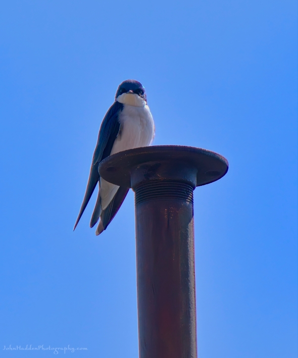
About Today’s Photo:
I haven’t seen tree swallows here in Huntington yet, but they were in attendance at our camp on North Hero the day after the eclipse. This one was staring me down from its perch on a pole by the shore while its partner dive-bombed me while I took the photo.
Panasonic Lumix DS-SZ200, ISO 125, f/8, 1/500″ exposure
Monday, April 15, 2024
 A bloodroot bud ready to unfurl
Morning Observation:
This morning in Huntington at 7:00AM it’s currently 42 degrees under cloudy skies. Winds are calm. Relative humidity is 97%, dewpoint 41, barometric pressure 29.76”. We picked up 0.15” of rain yesterday. Yesterday’s high was 54, and yesterday’s low was 32. The overnight low got down to 37.
This morning in North Hero it’s currently 44 degrees under cloudy skies. Winds are calm. Relative humidity is 99%, dewpoint 44, barometric pressure 29.77”. We picked up 0.06” of rain yesterday and 0.07” so far today. Yesterday’s high was 50, ynd yesterday’s low was 38. Flew 42.
Forecast Discussion:
Unsettled conditions will continue through much of today with on-and-off scattered showers expected as a weak upper level trough skirts through the region. Precipitation is expected to wind down later this evening as high pressure builds in bringing dry and seasonably mild conditions Tuesday and Wednesday. Low pressure tracking out of the Great Lakes on Thursday will bring our next chance of showers later Thursday night as it lifts a warm front into the region. Showers will continue through Friday when a cold front will swing through with showers lingering into Saturday. Highs Thursday through Saturday are expected to be in the upper 50s to low 60s. Dry and seasonable conditions return for Sunday.
3-Day Forecast:
We’ll see mostly cloudy skies today with a 30% chance of showers. Highs will be near 54 with west winds 3-8 mph. Rainfall amounts of less than 0.10″ are possible. Tonight should be partly cloudy with a 20% chance of showers. Lows will be around 37 with southwest winds around 7 mph.
Tuesday should be mostly sunny with a high near 54 and northwest winds 8-10 mph. Tuesday night should be partly cloudy with a low around 32 and north winds 6-9 mph.
Wednesday should be mostly sunny with a high near 54 and north winds around 6 mph. Wednesday night should be mostly cloudy with a low around 37 and light and variable winds becoming easterly around 5 mph after midnight.
Almanac:
Last year on this date in Huntington we had a high of 85 and a low of 47.
Last year in North Hero we had a high of 76 and a low of 43.
Burlington averages for this date are a low of 36 and a high of 55.
The record low was 20 in 1992.
The record high was 85 in 2023 (see above).
The Lake Champlain lake level in Burlington is 98.72′.
The water temperature is 41˚.
Last year’s lake level was at 98.06′.
The Mt. Mansfield snow stake depth is 65″.
The average depth for this date is 66″.
Mt. Washington Summit Conditions
Current Temperature: 27˚
Winds are out of the west at 27 mph
24 hr Precipitation: 2.9″ snow, 0.47″ melted precipitation
Visibility: less than 1/16 mile in freezing fog
Sky Notes:
Sunrise: 6:07AM
Sunset: 7:37PM
Length of day: 13:29:44
Today will be 2:56 longer than yesterday.
The Moon is in its first quarter, 7 days old with 45% illumination.
Moonrise: 11:08AM
Moonset: 2:45AM
About Today’s Photo:
Our patch of bloodroot down along Fargo Brook continues to push its way up through the leaf litter. There are a couple of buds ready to go, but the cold temperatures have kept them tightly under wraps. Like many spring ephemerals, bloodroot will wait for warm, sunny conditions before opening its blossoms for pollinators (likely flies at this time of year) then rewrap the blossoms with their leathery leaves overnight and during colder temperatures.
Panasonic Lumix DS-SZ200, ISO 400, f/8, 1/200″ exposure
Sunday, April 14, 2024
 Maple buds popping along Fargo Brook
Morning Observation:
This morning in Huntington at 7:50AM it’s currently 36 degrees under clear skies. Winds are calm. Relative humidity is 97%, dewpoint 35, barometric pressure 29.83”. We picked up 0.26” of rain yesterday and a dusting of snow overnight. We picked up 0.09” of rain/melted precipitation so far today. Yesterday’s high was 52, and yesterday’s low was 35. The overnight low got down to 32.
This morning in North Hero it’s currently 41 degrees under clear skies. Winds are out of the south at 3-4 mph. Relative humidity is 86%, dewpoint 38, barometric pressure 29.82”. we picked up 0.17” of rain yesterday. Yesterday’s high was 50, and yesterday’s low was 37. The overnight low got down to 38.
Forecast Discussion:
After a sunny start to the day today, clouds will be on the increase out ahead of a compact low pressure system currently over the Great Lakes. Showers are expected to move into Vermont this afternoon, continue overnight, and linger into Monday morning. Highs today will top out in the mid 50s. Monday’s looking mostly dry and seasonable as the aforementioned low tracks to our northeast during the day. High pressure is expected to build in for Tuesday and Wednesday with dry and seasonably mild conditions expected. Unsettled conditions are expected heading into the latter part of the week as low pressure heads our way from the Great Lakes bringing scattered showers Thursday and into the weekend.
3-Day Forecast:
We’ll see sunny skies this morning, giving way to mostly cloudy skies this afternoon with showers likely this afternoon. Highs will be near 53 with west winds 7-10 mph becoming southerly in the afternoon. Chance of precipitation is 80% with rainfall amounts of less than 0.10″ possible. Tonight should be cloudy with showers, mainly before 8:00PM. Lows will be around 39 with light and variable winds becoming northwesterly 5-7 mph after midnight. Chance of precipitation is 80% with rainfall amounts of less than 0.10″ possible.
Monday should be partly sunny with a 20% chance of morning showers. Highs will be near 55 with west winds 6-10 mph. Monday night should be mostly cloudy with a low around 37 and southwest winds around 7 mph.
Tuesday should be mostly sunny with a high near 57 and west winds 6-11 mph. Tuesday night should be partly cloudy with a low around 35 and north winds 5-9 mph.
Almanac:
Last year on this date in Huntington we had a high of 81 and a low of 47.
Last year in North Hero we had a high of 71 and a low of 50.
Burlington averages for this date are a low of 35 and a high of 55.
The record low was 17 in 1973.
The record high was 84 in 1968.
The Lake Champlain lake level in Burlington is 98.60′.
The water temperature is 42˚.
Last year’s lake level was at 97.97′.
The Mt. Mansfield snow stake depth is 63″.
The average depth for this date is 68″.
Mt. Washington Summit Conditions
Current Temperature: 18˚
Winds are out of the NE at 65 gusting to 86 mph
24 hr Precipitation: 3.2″ snow, 0.58″ melted precipitation
Visibility: less than 1/16 mile in freezing fog and blowing snow.
Sky Notes:
Sunrise: 6:09AM
Sunset: 7:35PM
Length of day: 13:26:48
Today will be 2:56 longer than yesterday.
The Moon is a waxing crescent, 6 days old with 35% illumination.
Moonrise: 10:03AM
Moonset: 1:58AM
About Today’s Photo:
I noticed yesterday driving through Richmond that the hillsides are starting to blush up as maple buds are popping. There’s a nice red maple down along Fargo Brook that is sporting its spring colors right now, and its intricate buds shone brightly in the sun the other day.
Sony A7II, Sigma 100-400mm lens @ 400mm, ISO 500, f/10, 1/500″ exposure
Saturday, April 13, 2024

 A phoebe in mid-call
Morning Observation:
This morning in Huntington at 7:10AM it’s currently 45 degrees under mostly cloudy skies. Winds are calm. Relative humidity is 87%, dewpoint 41, barometric pressure 29.32”. We picked up 0.51” of rain yesterday and 0.09” so far today. Yesterday’s high was 71, and yesterday’s low was 51. The overnight low got down to 45.
This morning in North Hero it’s currently 45 degrees under mostly cloudy skies. Winds are out of the south at 3-5 mph. Relative humidity is 89%, dewpoint 42, barometric pressure 29.33. We picked up 0.78” of rain yesterday and 0.06” so far today. Yesterday’s high was 61, and yesterday’s low was 45. The overnight low got down to 45.
Forecast Discussion:
Morning radar imagery shows deep low pressure to our north just south of James Bay. This low will continue to rotate showers into the region today and into early Sunday. Highs today will be much cooler than yesterday—in the upper 40s to low 50s—but with lighter winds. After a brief lull in precipitation midday Sunday, another trough is expected to swing through to the north bringing showers later Sunday afternoon into Sunday night. High pressure will build in briefly Monday night into Tuesday before low pressure moving into the Great Lakes brings more rain for later int the week.
3-Day Forecast:
We’ll see mostly cloudy skies today with showers likely mainly after 2:00PM. Highs will be near 48 with south winds 10-15 mph. Chance of precipitation is 80% with rainfall amounts of less than 0.10″ possible. Tonight should be cloudy with showers, mainly before 11:00PM. Lows will be around 36 with west winds 15-20 mph. Chance of precipitation is 80% with rainfall amounts between 0.10″-0.25″ possible.
Sunday should be mostly cloudy with showers likely, mainly after 4:00PM. Highs will be near 55 with west winds 8-10 mph. Chance of precipitation is 60% with rainfall amounts of less than 0.10″ possible. Sunday night should be mostly cloudy with showers likely, mainly before 9:00PM. Lows will be around 38 with south winds around 6 mph becoming light and variable. Chance of precipitation is 60% with rainfall amounts of less than 0.10″ possible.
Monday should be partly sunny with a high near 56 and west winds 6-10 mph. Monday night should be partly cloudy with a low around 38 and southwest winds around 7 mph.
Almanac:
Last year on this date in Huntington we had a high of 87(!) and a low of 41.
Last year in North Hero we had a high of 81 and a low of 41.
Burlington averages for this date are a low of 35 and a high of 54.
The record low was 20 in 2000 (we had a low of 16 in Huntington).
The record high was 88 in 2023 (see above).
The Lake Champlain lake level in Burlington is 98.31′.
The water temperature is 41˚.
Last year’s lake level was at 97.89′.
The Mt. Mansfield snow stake depth is 70″ (as of 4/11).
The average depth for this date is 70″.
Mt. Washington Summit Conditions
Current Temperature: 28˚
Winds are out of the south at 38 gusting to 48 mph
24 hr Precipitation: 1.38″ rain
Visibility: about 1/16 mile in freezing fog
Sky Notes:
Sunrise: 6:10AM
Sunset: 7:34PM
Length of day: 13:23:51
Today will be 2:57 longer than yesterday.
The Moon is a waxing crescent, 5 days old with 25% illumination.
Moonrise: 9:04AM
Moonset: 12:58AM
About Today’s Photo:
Spring is coming on strong here in Huntington, and the number of different bird calls in the morning is quite amazing! The phoebes have returned as well and this noisy little fellow was making his presence known with his distinctive “feeee-bee!” call.
Sony A7II, Sigma 100-400mm lens @ 400mm, ISO 640, f/10, 1/500″ exposure
Friday, April 12, 2024

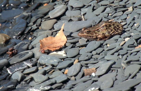 A leopard frog warming in the sunshine on the beach in North Hero
Morning Observation:
This morning in Huntington at 7:50AM it’s currently a balmy and blustery 60 degrees under mostly cloudy skies. Got a little sunshine going on right now. Winds are out of the southeast at 8-10 gusting to 15 mph. Relative humidity is 85%, dewpoint 55, barometric pressure 29.35”. We picked up 0.08” of rain yesterday and 0.08” so far today. Yesterday’s high was 56, and yesterday’s low was 43. The overnight low got down to 53.
This morning in North Hero it’s currently 51 degrees under mostly cloudy skies. Winds are out of the south at 8-10 mph gusting to 17 mph. Relative humidity is is 94%, dewpoint 49, barometric pressure 29.35”. We picked up 0.11” of rain yesterday and 0.05” so far today. Yesterday’s high was 52, and yesterday’s low was 43. The overnight low got down to 47.
There is a Wind Advisory in effect for Huntington until 2:00PM today.
Forecast Discussion:
Morning radar imagery shows low pressure just beginning to slide north and east of the Great Lakes with bands of showers pivoting around it to the east and north. There’s currently a dry slot over a good portion of Vermont with breaks of sun occurring at this hour. This should be short-lived however as showers begin to lift back into the region within the next couple of hours. The low will drag a cold front across the region later this afternoon kicking off more widespread rains with some imbedded thunderstorms this afternoon and evening. Highs today will top out in the upper 60s to low 70s with gusty southwest winds. Showery and unsettled conditions will persist through much of the weekend as the aforementioned low continues to rotate bands of showers through early Sunday. Highs on Saturday will be in the upper 40s with mid 50s expected Sunday. Showers should finally wind down Sunday night as a brief ridge of high pressure builds in for Monday. More showers are expected Monday night with drier conditions expected Tuesday into Wednesday.
3-Day Forecast:
We’ll see mostly cloudy skies today with showers and thunderstorms likely especially this afternoon. Highs will be near 67 with southeast winds 21-29 mph gusting to 45 mph. Chance of precipitation is 80% with rainfall amounts between 0.10″-0.25″ with higher amounts possible in thunderstorms. Tonight should be mostly cloudy with showers likely, mainly before 8:00PM. Lows will be around 43 with south winds 16-21 mph gusting to 32 mph. Chance of precipitation is 60% with rainfall amounts between 0.10″-0.25″ possible.
Saturday should be cloudy with showers. Highs will be near 48 with south winds around 14 mph. Chance of precipitation is 80% with rainfall amounts between 0.10″-0.25″ possible. Saturday night should be mostly cloudy with showers likely, mainly before 10:00PM. Lows will be around 36 with west winds 11-15 mph. Chance of precipitation is 70 rainfall amounts of less than 0.10″ possible.
Sunday should be mostly cloudy with a 40% chance of afternoon showers. Highs will be near 53 with southwest winds 7-11 mph. Rainfall amounts of less than 0.10″ are possible. Sunday night should be mostly cloudy with a 30% chance of showers. Lows will be around 40 with west winds around 5 mph becoming calm.
Almanac:
Last year on this date in Huntington we had a high of 63 and a low of 41.
Last year in North Hero we had a high of 60 and a low of 42.
Burlington averages for this date are a low of 34 and a high of 53.
The record low was 16 in 1976.
The record high was 82 in 1945.
The Lake Champlain lake level in Burlington is 98.00′.
The water temperature is 40˚.
Last year’s lake level was at 97.74′.
The Mt. Mansfield snow stake depth is 70″.
The average depth for this date is 70″.
Mt. Washington Summit Conditions
Current Temperature: 40˚
Winds are out of the south at 57 gusting to 83 mph
24 hr Precipitation: 0.83″ rain
Visibility: about 1/16 mile in rain and fog
Sky Notes:
Sunrise: 6:12AM
Sunset: 7:33PM
Length of day: 13:20:54
Today will be 2:58 longer than yesterday.
The Moon is a waxing crescent, 4 days old with 16% illumination.
Moonrise: 8:15AM
No Moonset
About Today’s Photo:
The frogs are active up in North Hero. The swamp between the north and south coves on our little point was alive with woodfrogs croaking (as is our pond here in Huntington), and this leopard frog was enjoying the sunshine on the warm stones of the beach the other day.
Panasonic Lumix DS-SZ200, ISO 125, f/8, 1/500″ exposure
Thursday, April 11, 2024

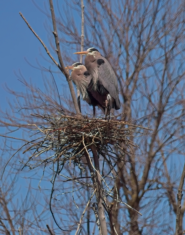 A pair-a-herons on their nest
Morning Observation:
This morning in Huntington at 7:05AM it’s currently 46 degrees under mostly cloudy skies. Winds are calm. Relative humidity is 95%, dewpoint 44, barometric pressure 29.99”. We picked up 0.25” of rain yesterday. Yesterday’s high was 63, and yesterday’s low was 39. The overnight low got down to 43.
This morning in North Hero it’s currently 45 degrees under mostly cloudy skies. Winds are calm. Relative humidity is 93%, dewpoint 43, barometric pressure 29.99”. We picked up 0.13” of rain yesterday. Yesterday’s high was 56, and yesterday’s low was 44. The overnight low got down to 43.
Forecast Discussion:
We’ve got a rainy several days ahead of us as low pressure currently over the mid-Mississippi Valley slides northeastward into the Great Lakes today. The low will lift a warm front into the North Country during the day accompanied by numerous shower which should be moving into the region by midmorning. A dry slot is expected to move overhead later this afternoon bringing a pause to the rainfall action, but showers will likely return tonight and through the overnight hours. Highs today will top out in the upper 50s to low 60s once again. As the low lifts into Ontario & Québec on Friday, it will drag a cold front through the region bringing renewed chances for showers along with some rumble of thunder and gusty southeast winds. Even with the “cold” front, however, temperatures will continue to unseasonably warm in the mid 60s on Friday. Showers will linger into Saturday, diminishing into Sunday as the low slowly pulls away to the northeast. Highs on Saturday will be more seasonable—in the upper 40s with mid to upper 50s expected for Sunday. Dry conditions return briefly for Monday with more rain and warm temperatures expected for midweek.
3-Day Forecast:
We’ll see mostly cloudy skies today with rain showers likely. Winds will be out of the southeast at 8-16 mph. Chance of precipitation is 90% with rainfall amounts of less than 0.10″ possible. Tonight should be cloudy with showers, mainly after 8:00PM. Lows will be around 52 with southeast winds 21-26 mph gusting to 39 mph. Chance of precipitation is 80% with rainfall amounts between 0.10″-0.25″ possible.
Friday should be cloudy with showers, with thunderstorms also possible after 1:00PM. Highs will be near 65 with southeast winds 18-24 mph gusting to 36 mph. Chance of precipitation is 80% with rainfall amounts between 0.25″-0.50″ possible. Friday night should be mostly cloudy with showers likely, mainly before 8:00PM. Lows will be around 43 with south winds 14-16 mph. Chance of precipitation is 60% with rainfall amounts between 0.10″-0.25″ possible.
Saturday should be cloudy with showers. Highs will near 49 with south winds 10-15 mph becoming westerly in the afternoon. Chance of precipitation is 80% with rainfall amounts between 0.10″-0.25″ possible. Saturday night should be mostly cloudy with a 50% chance of showers. Lows will be around 38 with west winds 11-17 mph gusting to 24 mph. Rainfall amounts between 0.10″-0.25″ are possible.
Almanac:
Last year on this date in Huntington we had a high of 69 and a low of 42.
Last year in North Hero we had a high of 66 and a low of 44.
Burlington averages for this date are a low of 34 and a high of 53.
The record low was 12 in 1974.
The record high was 84 in 1945.
The Lake Champlain lake level in Burlington is 97.97′.
The water temperature is 41˚.
Last year’s lake level was at 97.68′.
The Mt. Mansfield snow stake depth is 81″ (reported 4/9).
The average depth for this date is 70″.
Mt. Washington Summit Conditions
Current Temperature: 38˚
Winds are out of the south at 22 gusting to 33 mph
24 hr Precipitation: 0.28″ rain
Visibility: less than 1/16 mile in fog
Sky Notes:
Sunrise: 6:14AM
Sunset: 7:32PM
Length of day: 13:17:55
Today will be 2:58 longer than yesterday.
The Moon is a waxing crescent, 3 days old with 9% illumination.
Moonrise: 7:36AM
Moonset: 11:46PM
About Today’s Photo:
We visited a heronry in the islands the other day and there was quite a bit of activity as nesting season is getting underway. There were a few pairs already set to go, and several solo birds working industriously on their nests. The heronry is on private land so I’m not at liberty to divulge its location.
Sony A7II, Sigma 100-400mm lens @ 400mm, ISO 125, f/10, 1/500″ exposure
Wednesday, April 10, 2024
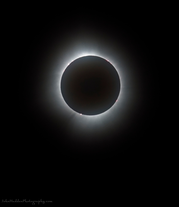 The eclipse at totality with solar flares along its limb
Morning Observation:
This morning in Huntington at 7:00AM it’s currently 46 degrees and raining under overcast skies. Winds are calm. Relative humidity is 96%, dewpoint 45, barometric pressure 29.98”. We’ve picked up 0.08” of rain so far today and are finally down to bare ground at the stake. Yesterday’s high was 70, and yesterday’s low was 32. The overnight low got down to 39.
This morning in North Hero it’s currently 47 degrees and raining lightly under overcast skies. Winds are out of the south at 9-11 mph. Relative humidity is 80%, dewpoint 41, barometric pressure 29.93”. We picked up 0.02” of rain so far today. Yesterday’s high was 62, and yesterday’s low was 38. The overnight low got down to 44.
Forecast Discussion:
Unsettled weather looks to be the rule through the end of the week and heading into the weekend. Morning radar imagery shows low pressure just west of James Bay with an associated warm front dropping southward across Lake Ontario. This frontal boundary is expected to move across the region and slow today as showers and possible thunderstorms move along it during the day today. Highs today will be in the mid 50s to low 60s. Showers are expected to wind down tonight for a brief lull in precipitation. Low pressure currently over Arkansas will move northeastward into the Great Lakes on Thursday. The low will lift a warm front through the region Thursday bringing widespread rains and possible thunderstorms along with gusty south winds. Rains could be heavy at times. As the low tracks into Ontario and Québec on Friday, it will drag a cold front through the region bringing renewed chances for showers and thunderstorms. Warm temperatures, wind, rain, and snowmelt will all combine to raise river levels Thursday into Friday with some minor flooding possible. Scattered light showers will persist into Saturday with drier conditions expected Sunday.
3-Day Forecast:
We’ll see cloudy skies today with showers. Highs will be near 57 with south winds 9-14 mph in Huntington and 20-24 over Lake Champlain gusting to 34 mph. Chance of precipitation is 80% with rainfall amounts between 0.10″-0.25″ possible. Tonight should be cloudy with showers. Lows will be around 45 with south winds 5-10 mph. Chance of precipitation is 60% with rainfall amounts of less than 0.10″ possible.
Thursday should be cloudy with rain likely. Highs will be near 58 with southeast winds 8-16 mph. Chance of precipitation is 70% with rainfall amounts of less than 0.10″ possible. Thursday night should be cloudy with rain. Lows will be around 52 with southeast winds 18-23 mph gusting to 37 mph. Chance of precipitation is 90% with rainfall amounts between 0.10″-0.25″ possible.
Friday should be cloudy with rain before 11:00AM, diminishing to showers. Highs will be near 64 with southeast winds 18-23 mph gusting to 36 mph. Chance of precipitation is 90% with rainfall amounts between 0.25″-0.50″ possible. Friday night should be cloudy with showers. Lows will be around 42 with south winds around 15 mph. Chance of precipitation is 80% with rainfall amounts between 0.10″-0.25″ possible.
Almanac:
Last year on this date in Huntington we had a high of 65 and a low of 25.
Last year in North Hero we had a high of 60 and a low of 35.
Burlington averages for this date are a low of 34 and a high of 52.
The record low was 16 in 1975.
The record high was 81 in 1945.
The Lake Champlain lake level in Burlington is 97.83′.
The water temperature is 40˚.
Last year’s lake level was at 97.61′
The Mt. Mansfield snow stake depth is 81″.
The average depth for this date is 70″.
Mt. Washington Summit Conditions
Current Temperature: 32˚
Winds are out of the SW at 48 gusting to 54 mph
24 hr Precipitation: 0
Visibility: around 60 miles under clear skies.
Sky Notes:
Sunrise: 6:16AM
Sunset: 7:30PM
Length of day: 13:14:57
Today will be 2:59 longer than yesterday.
The Moon is a waxing crescent, 1.7 days old with 3% illumination.
Moonrise: 7:04AM
Moonset: 10:27PM
About Today’s Photo:
I thought I’d share one more photo from the eclipse at totality. You can clearly see the corona spreading out into space and several bright spots where solar flares are popping—particularly down near the bottom left. Back to earth tomorrow…
Sony A7II, Sigma 100-400mm lens @ ISO 100, f/10, 1/80″ exposure
Tuesday, April 9, 2024

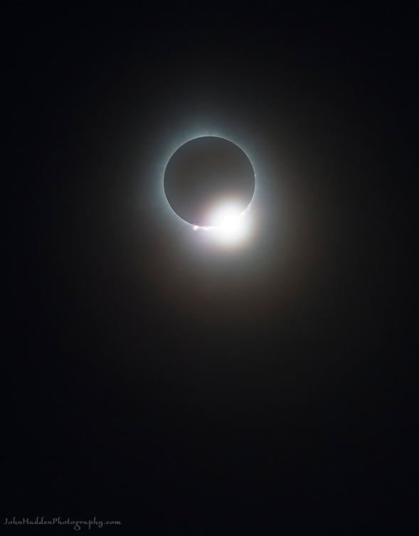 The “diamond ring” phase of yesterday’s eclipse
Well yesterday was certainly a day to remember for us here Vermont! I hope you had as an amazing experience as we did up here on the lake!
Morning Observation:
This morning in North Hero at 7:50AM it’s currently 43 degrees under clear skies. Winds are calm. Relative humidity is 85%, dewpoint 38, barometric pressure 30.15”. Yesterday’s high was 57, and yesterday’s low was 37. The overnight low got down to 38.
This morning in Huntington it’s currently 37 degrees under clear skies. Winds are calm. Relative humidity is is 96%, dewpoint 36, barometric pressure 30.06”. Yesterday’s high was 62, and yesterday’s low was 28. The overnight low got down to 32. We’re down to a spotty 1” of snow at the stake.
Forecast Discussion:
High pressure cresting over the region this morning will bring another lovely early spring day with mostly sunny skies and highs topping out in the upper 60s to near 70s. Low pressure tracking to our north will swing an occluded/warm front through the region overnight tonight bringing some scattered showers to the region overnight and lingering into Wednesday. Highs on Wednesday will remain well above seasonal norms—in the upper 40s/low 50s east of the Greens and upper 50s/low 60s west. A more potent storm system is expected for later in the week. A developing surface low will lift northward out of the lower Mississippi River Valley and towards the Great Lakes Region through the day on Thursday, deepening as it goes. The low will lift a warm front through the North Country on Thursday bringing an initial wave of rain showers to the area during the midday hours Thursday. Rains will continue through the Thursday night, becoming heavy at times, accompanied by gusty winds. A trailing cold front will swing through the region Friday bringing more convective showers and thunderstorms. Heavy rains combined with warm temperatures, wind, and snowmelt will increase the possibility of some minor flooding in area rivers. Unsettled conditions will persist into the weekend as the aforementioned low takes its time moving out.
3-Day Forecast:
We’ll see mostly sunny skies today with a high near 63 and calm winds becoming northwesterly around 5 mph in the afternoon. Tonight should be mostly cloudy with a 30% chance of showers late. Lows will be around 41 with southeast winds 5-10 mph.
Wednesday should be cloudy with showers likely. Highs will be near 55 with southeast winds 10-13 mph. Chance of precipitation is 70% with rainfall amounts between 0.10″-0.25″ possible. Wednesday night should be mostly cloudy with a 40% chance of showers. Lows will be around 44 with southeast winds 6-8 mph. Rainfall amounts of less than 0.10″ are possible.
Thursday should be cloudy with rain, mainly after 2:00PM. Highs will be near 56 with southeast winds 7-13 mph. Chance of precipitation is 80% with rainfall amounts of less than 0.10″ possible. Thursday night should be cloudy with rain. Lows will be around 52 with a southeast winds 18-23 mph gusting to 34 mph. Chance of precipitation is 100% with rainfall amounts between 0.25″-0.50″ possible.
Almanac:
Last year on this date in Huntington we had a high of 54 and a low of 21.
Last year in North Hero we had a high of 47 and a low of 30.
Burlington averages for this date are a low of 33 and a high of 52.
The record low was 14 in 1997.
The record high was 76 in 2021 (we had a high of 77 in Huntington).
The Lake Champlain lake level in Burlington is 97.87′.
The water temperature is 40˚
Last year’s lake level was at 97.62′.
The Mt. Mansfield snow stake depth is 86″.
The average depth for this date is 70″.
Mt. Washington Summit Conditions
Current Temperature: 29˚
Winds are out of the north at 37 gusting to 43 mph
24 hr Precipitation: 0
Visibility: around 100 miles under clear skies.
Sky Notes:
Sunrise: 6:17AM
Sunset: 7:29PM
Length of day: 13:11:57
Today will be 2:59 longer than yesterday.
The Moon is a waxing crescent, 0.6 days old with 0.5% illumination.
Moonrise: 6:38AM
Moonset: 9:07PM
About Today’s Photo:
Words really can’t describe the experience of yesterday’s eclipse. I just wasn’t prepared for the suddenness of the utter transformation of being enveloped in the moon’s shadow, and I was a bit paralyzed between trying to photograph something that remotely captured the experience, and just standing there with my jaw on the ground. I’d never have imagined that something could transform the entire world of light and shadows so abruptly and completely. Still, I managed to get a few decent shots of the totality including this one of the “diamond ring” phase when the sun is just beginning to peek out from behind the moon’s shadow. The sun’s corona is clearly visible as are a few “Bailey beads” of sunlight leaking out through the canyons and mountains of the moon’s surface.
Sony A7II, Sigma 100-400mm lens @ 400mm, ISO 2000, f/10, 1/125″ exposure
Monday, April 8, 2024; Eclipse Day!

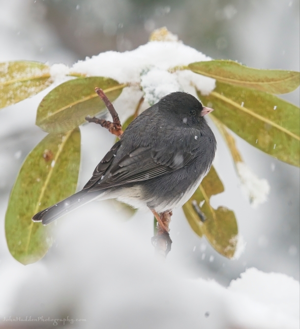 A junco in the falling snow
Happy Eclipse Day!
Morning Observation:
This morning in North Hero at 7:20AM it’s currently 39 degrees under clear skies. Winds are out of the south at 5-8 mph. Relative humidity is 85%, dewpoint 35, barometric pressure 30.15”. Yesterday’s high was 55, and yesterday’s low was 33. The overnight low got down to 37.
This morning in Huntington it’s currently 28 degrees under clear skies. Winds are calm. Relative humidity is 96%, dewpoint 27, barometric pressure 30.16”. We have 3” of snow at the stake. Yesterday’s high was 50, and yesterday’s low was 30. The overnight low got down to 28.
Forecast Discussion:
It’s a lovely morning to kick off Eclipse Day, but, unfortunately, the high, thin clouds that were predicted for later this afternoon have their own timetable in mind and will likely be moving into western sections earlier than previously forecast. While the clouds won’t completely block out the eclipse this afternoon, they will filter it somewhat so that views of the solar corona will be less distinct. Still, Vermont seems to be one of the only places in the US that will have clear skies for the event, so we should count ourselves lucky indeed! Highs today will be in the upper 50s to low 60s with light winds. Clouds will continue to increase through the night tonight out ahead of a frontal boundary which will swing through the region Tuesday night into Wednesday bringing some scattered showers to the region. A more potent storm system is expected to impact the region Thursday, through Friday, and into the weekend bringing widespread rain which may be heavy at times. Flooding concerns will be on the table later Thursday night into Friday as unseasonably warm temperatures, gusty winds, and rains accelerate snowmelt. Unsettled conditions will continue into the weekend with dry conditions returning Sunday.
3-Day Forecast:
We’ll see increasing clouds today with a high near 57 and calm winds becoming westerly 5-7 mph in the afternoon. Tonight should be partly cloudy with a low around 37 and light southwest winds.
Tuesday should be partly sunny with a high near 62 and calm winds becoming northwesterly around 5 mph in the afternoon. Tuesday night should be cloudy with a 30% chance of showers late. Lows will be around 40 with southeast winds 5-9 mph. Rainfall amounts of less than 0.10″ are possible.
Wednesday should be cloudy with showers likely. Highs will be near 54 with south winds around 10 mph. Chance of precipitation is 60% with rainfall amounts of less than 0.10″ possible. Wednesday night should be mostly cloudy with a 40% chance of showers. Lows will be around 43 with southeast winds around 9 mph. Rainfall amounts of less than 0.10″ are possible.
Almanac:
Last year on this date in Huntington we had a high of 44 and a low of 21.
Last year in North Hero we had a high of 46 and a low of 28.
Burlington averages for this date are a low of 33 and a high of 51.
The record low was 11 in 1972.
The record high was 73 in 2021 (we had a high of 75 in Huntington).
The Lake Champlain lake level in Burlington is 97.84′.
The water temperature is 39˚.
Last year’s lake level was at 97.60′.
The Mt. Mansfield snow stake depth is 90″.
The average depth for this date is 69″.
Mt. Washington Summit Conditions
Current Temperature: 25˚
Winds are out of the north at 30-35 mph
24 hr Precipitation: 0
Visibility: about 110 miles under clear skies.
Sky Notes:
Sunrise: 6:19AM
Sunset: 7:28PM
Length of day: 13:08:57
Today will be 3:00 longer than yesterday.
The Moon is new, 29 days old with 0% illumination (has to be for the eclipse!)
Moonrise: 6:15AM
Moonset: 7:41PM
No doubt you’re aware that today is Eclipse Day, and I’m sure that you’ve heard plenty about it over the past couple of weeks since it seems that it’s all anyone is talking about! All the same, this is truly a once-in-a-lifetime event, especially for our little corner of the planet.
Here are some Eclipse stats for Burlington:
The eclipse will begin at 2:14PM
Totality will begin 3:26PM and continue through 3:29PM for 3m16s of totality.
The eclipse will end at 4:37PM
I hope you have a chance to view it and please be sure to use the proper precautions when doing so!
