Tuesday, May 31, 2016
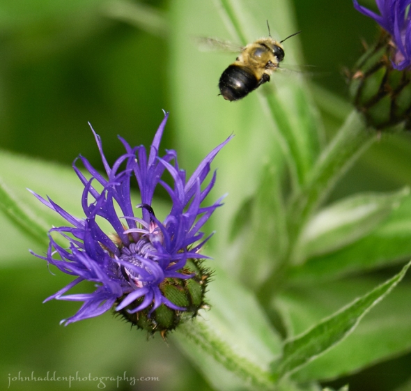
A bumble bee commutes between Centurian blossoms in our back garden
Morning Observation:
This morning in Huntington at 7:05AM it’s currently 56 degrees under clear skies. Winds are calm. Relative humidity is 99%, dewpoint 56, barometric pressure 29.89” and rising slowly. Yesterday’s high was 84, and the overnight low was 51.
Forecast:
A weak upper level disturbance passing north of the region this afternoon will
bring scattered clouds and perhaps a few light showers or sprinkles to northern mountain communities. Otherwise dry and seasonably warm conditions are expected through Thursday as high pressure builds across the northeast.
We’ll see sunny skies today with highs in the mid 70s and southwest winds around 10 mph, becoming northwesterly and gusting up to 30 mph this afternoon. Tonight should be partly cloudy until midnight, then clearing. Lows will be in the upper 40s with northwest winds 10 to 15 mph gusting up to 30 mph until midnight, then becoming light and variable.
Wednesday should be mostly sunny with highs in the upper 70s and light and variable winds. Wednesday night should be partly cloudy with lows in the mid 50s and southeast winds 10 to 15 mph.
Thursday’s looking partly sunny with highs in the upper 70s and southeast winds 10 to 15 mph gusting up to 25 mph. Thursday night should be mostly cloudy with a 50% chance of showers as low pressure approaches. Lows will be in the mid 50s.
Almanac:
Last year on this date we had a high of 66 and a low of 46. We picked up 2.31″ of rain.
Burlington averages for this date are highs of 72 and lows of 50.
The record high was 91°F in 2013 (we had a high of 89).
The record low was 25°F in 1961.
Sky Notes:
Sunrise: 5:11 AM EDT
Sunset: 8:28 PM EDT
Length of Visible Light: 16h 28m
Length of Day: 15h 17m
Tomorrow will be 1m20s longer.
The Moon is a waning crescent, 24d 15h old with 28% illumination.
Moonrise: 2:29 AM EDT
Moonset: 3:04 PM EDT
About Today’s Photo:
Pollinators are happy critters this time of year. I followed a bumble bee as it moved between the blossoms of a centurian in our backyard garden.
Panasonic GX8, Lumix 100-300mm lens @ 300mm, ISO 800, f/5.6, 1/800″ exposure.
Monday, May 30, 2016

A bumble bee works a buckeye tree bloom by our pond
Morning Observation:
This morning in Huntington at 7:55AM it’s currently a damp 67 degrees under cloudy skies. Winds are calm. Relative humidity is 96%, dewpoint 66, barometric pressure 29.89”. We picked up 0.80” of rain in the past 24hrs. Yesterday’s high was 87, and the overnight low was 64.
Forecast:
A warm front is draped across the region this morning, but a cold front will push through later this afternoon kicking off more showers and thunderstorms with its passage. High pressure will build in for the middle of the week.
We’ll see partly sunny skies with a 50% chance of showers and a slight chance of thunderstorms this afternoon. Highs will be in the lower 80s with southwest winds around 10 mph. High pressure will build in behind the departing cold front tonight bringing partly cloudy skies. Lows will be in the upper 50s with southwest winds around 10 mph.
Tuesday should be partly sunny with highs in the mid 70s and west winds around 10 mph, becoming northwesterly and gusting up to 30 mph in the afternoon. Tuesday night should be partly cloudy with lows in the upper 40s and northwest winds 10 to 15 mph gusting up to 30 mph.
Wednesday’s looking sunny with highs in the mid 70s and light and variable winds. Wednesday night should be mostly clear with lows in the mid 50s.
Almanac:
Last year on this date we had a high of 84 and a low of 56.
Burlington averages for this date are highs of 72 and lows of 50.
The record high was 92°F in 1929.
The record low was 28°F in 1961.
Sky Notes:
Sunrise: 5:11 AM EDT
Sunset: 8:27 PM EDT
Length of Visible Light: 16h 26m
Length of Day: 15h 15m
Tomorrow will be 1m25s longer.
The Moon is a waning crescent, 23d 16h old with 39% illumination.
Moonrise: 1:56 AM EDT
Moonset: 1:52 PM EDT
About Today’s Photo:
Fast growing buckeyes are in bloom now. These trees can grow as much as a foot a year have fragrant conical flowers that are very attractive to pollinators.
Panasonic GX8, Lumix 100-300mm lens @ 234mm, ISO 800, f/8, 1/1300″ exposure.
Friday, May 27, 2016
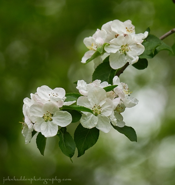
Apple blossoms on one of the wild trees along Fargo Brook
Morning Observation:
This morning in Huntington at 6:30AM it’s currently 61 degrees under overcast skies. Winds are calm. Relative humidity is 98%, dewpoint 61, barometric pressure 29.97” and falling slowly. We picked up 0.06” of rain overnight. Yesterday’s high was 81, and the overnight low was 60.
Forecast:
Unseasonably warm and humid weather and occasional convection triggered afernoon showers will be the rule through the Memorial Day weekend, with showers likely on Sunday and Monday.
We’ll see partly sunny skies today with a 20% chance of showers and thunderstorms this afternoon. Highs will be in the mid 80s with south winds around 10 mph. Tonight should be partly cloudy with a 20% chance of showers and thunderstorms until midnight. Lows will be in the mid 60s with southwest winds around 10 mph until midnight, becoming light and variable.
Saturday should be partly sunny and dry as an upper level ridge crests over the region. Highs in the mid 80s (pushing 90 in warmer valley locations) and light and variable winds. Saturday night should be partly cloudy with lows in the mid 60s and light and variable winds.
An upper level trough will swing through Sunday bringing showers and thunderstorms by the afternoon. Highs will be in the lower 80s with light and variable winds. Chance of rain is 70%. Sunday night showers and thunderstorms are likely. Lows will be in the lower 60s. Chance of rain is 70%.
A cold front will move through the region Monday kicking off more showers and thunderstorms. Temperatures will remain well above seasonal averages.
Almanac:
Last year on this date we had a high of 86 and a low of 63.
Burlington averages for this date are highs of 71 and lows of 49.
The record high was 91°F in 1944.
The record low was 28°F in 1969.
Sky Notes:
Sunrise: 5:13 AM EDT
Sunset: 8:25 PM EDT
Length of Visible Light: 16h 21m
Length of Day: 15h 11m
Tomorrow will be 1m36s longer.
The Moon is waning gibbous, 20d 15h old with 72% illumination.
Moonrise: 12:09 AM EDT
Moonset: 10:30 AM EDT
About Today’s Photo:
It’s looking like another good year for apples this time around. Many of the wild apple trees on our property have had prodigious blooms. There’s more cider in our future!
Panasonic GX8, Lumix 100-300mm lens @ 150mm, ISO 800, f/5, 1/2000″ exposure.
Thursday, May 26, 2016
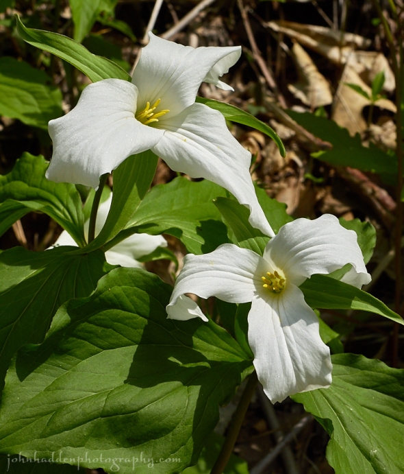
Large-flowered trillium blooming near Monkton Ridge
Morning Observation:
This morning in Huntington at 6:30AM it’s currently 51 degrees under party cloudy skies. Winds are calm. Relative humidity is 98%, dewpoint 50, barometric pressure 30.11” and rising slowly. We picked up a just a trace of rain in the past 24hrs. Yesterday’s high was 83, and the overnight low was 48.
Forecast:
We can expect dry weather for much of the day today with above normal temperatures and plenty of sunshine. An upper level trough will move across the region tonight and bringing increasing moisture and the threat of showers and a few thunderstorms overnight. The Memorial Day weekend will then feature above normal temperatures, more humid conditions, and the threat for afternoon
and evening convection triggered showers and thunderstorms.
We’ll see mostly sunny skies today with highs in the upper 70s and light and variable winds. Tonight should be partly cloudy with a 40% chance of showers and a slight chance of thunderstorms. Lows will be around 60 with light and variable winds, becoming southeasterly around 10 mph after midnight.
Friday should be partly sunny with a 40% chance of showers and thunderstorms mainly in the afternoon. Highs will be in the mid 80s with southwest winds around 10 mph in the morning, becoming light and variable. Friday night should be partly cloudy with lows in the mid 60s and light and variable winds.
Saturday’s looking mostly cloudy with a 50% chance of showers and thunderstorms. Highs will be in the upper 80s to near 90 with light and variable winds. Saturday night should be partly cloudy with a 50% chance of showers. Lows will be in the lower 60s.
Almanac:
Last year on this date we had a high of 86 and a low of 61. We picked up 0.15″ of rain.
Burlington averages for this date are highs of 70 and lows of 49.
The record high was 92°F in 2010 (we had a high of 88).
The record low was 32°F in 1969.
Sky Notes:
Sunrise: 5:14 AM EDT
Sunset: 8:24 PM EDT
Length of Visible Light: 16h 19m
Length of Day: 15h 09m
Tomorrow will be 1m37s longer.
The Moon is waning gibbous, 19d 15h old with 81% illuminaiton.
No Moon Rise
Moonset: 9:28 AM EDT
About Today’s Photo:
Large-flowered Trillium (a.k.a. White Wake Robin) blooms in rich lime soils in our region especially near Lake Champlain. There’s a stretch along the Monkton Ridge Road that has several batches and they’re in full bloom now. The new flowers are crisp white and slowly take on a pinkish hue as the flowers age. The flowers can remain open for two to three weeks!
Panasonic GX8, Lumix 30mm macro lens, ISO 400, f/9, 1/1300″ exposure.
Wednesday, May 25, 2016
Wild oats in bloom along the Mailbox Trail
Morning Observation:
This morning in Huntington at 7:30AM it’s currently 57 degrees under mostly clear skies. Winds are calm. Relative humidity is 99%, dewpoint 57, barometric pressure 29.96” and rising slowly. Yesterday’s high was 79, and the overnight low was 46.
Forecast:
A cold front will move into the area this afternoon and enhance the potential for thunderstorms, some of which could produce gusty winds. Dry weather is expected on Thursday, but increasing moisture through the Memorial Day weekend
will combine with the above normal temperatures to bring about chances for afternoon and evening showers or thunderstorms.
We’ll see partly sunny skies this morning, then a 40% chance of showers and thunderstorms this afternoon as the front crossed the region. Some thunderstorms may produce gusty winds this afternoon. Highs will be in the lower 80s with light and variable winds, becoming westerly around 10 mph this afternoon. Tonight should be partly cloudy with a 40% chance of showers and thunderstorms until midnight, then mostly clear after midnight. Some thunderstorms may produce gusty winds until midnight. Lows will be in the lower 50s with northwest winds around 10 mph.
Thursday should be mostly sunny with highs in the upper 70s and light and variable winds. Thursday night should be partly cloudy with a 30% chance of showers. Lows will be in the upper 50s with southeast winds around 10 mph.
Friday’s looking partly sunny with a 50% chance of showers. Highs will be in the lower 80s with south winds around 10 mph. Friday night should be partly cloudy with a 40% chance of showers. Lows will be in the lower 60s.
Almanac:
Last year on this date we had a high of 71 and a low of 41.
Burlington averages for this date are highs of 70 and lows of 48.
The record high was 91°F in 1946.
The record low was 28°F in 1956.
Sky Notes:
Sunrise: 5:15 AM EDT
Sunset: 8:23 PM EDT
Length of Visible Light: 16h 17m
Length of Day: 15h 08m
Tomorrow will be 1m42s longer.
The Moon is waning gibbous, 18d 16h old with 88% illumination.
Moonrise: 11:27 PM EDT
Moonset: 8:30 AM EDT
About Today’s Photo:
Wild oats are a lovely pendant flower that grows low to the ground and blooms this time of year. There are sections of the Mailbox Trail that are carpeted with these fine blooms.
Tuesday, May 24, 2016
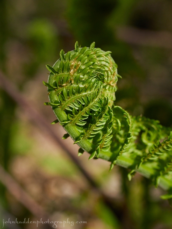
A Fiddlehead unfurls in the woods across Fargo Brook
Morning Observation:
This morning in Huntington at 7:55AM it’s currently 52 degrees under partly cloudy skies. Winds are calm. Relative humidity is 95%, dewpoint 50, barometric pressure 29.90”. Yesterday’s high was 78, and the overnight low was 44.
Forecast:
An upper level low just off the mid-Atlantic coast this morning will move northeast today into eastern Maine tonight. This will bring clouds to the area along with the threat of showers across Vermont and parts of the northern Adirondacks. Dry weather is expected Wednesday morning, but another upper level
disturbance will move across the area Wednesday afternoon and bring a chance of showers and thunderstorms. Above normal temperatures are expected today and Wednesday with highs in the mid 70s to lower 80s.
We’ll see partly sunny skies with a slight chance of showers this morning, then mostly cloudy skies with a 40% chance of showers and a slight chance of thunderstorms this afternoon. Highs will be in the upper 70s with light and variable winds. Tonight should be mostly cloudy with a slight chance of showers and thunderstorms until midnight, then partly cloudy after midnight. Lows will be in the mid 50s with light and variable winds. Chance of rain is 20%.
Wednesday should start out partly sunny in the morning then become cloudy with a 50% chance of showers and thunderstorms in the afternoon. Highs will be in the upper 70s with southwest winds around 10 mph. Wednesday night should be partly cloudy with a 40% chance of showers and thunderstorms. Lows will be in the lower 50s with northwest winds around 10 mph.
Thursday’s looking mostly sunny with highs in the upper 70s and light and variable winds. Thursday night should be partly cloudy with a 50% chance of showers. Lows will be in the upper 50s.
Almanac:
Last year on this date we had a high of 78 and a low of 41.
Burlington averages for this date are highs of 70 and lows of 48.
The record high was 88°F in 1991.
The record low was 28°F in 1963.
Sky Notes:
Sunrise: 5:16 AM EDT
Sunset: 8:22 PM EDT
Length of Visible Light: 16h 16m
Length of Day: 15h 06m
Tomorrow will be 1m44s longer.
The Moon is waning gibbous, 17d 16h old with 94% illumination.
Moonrise: 10:41 PM EDT
Moonset: 7:37 AM EDT
About Today’s Photo:
Ferns are unfurling with force in the woods now. This fiddlehead is unwinding along the trail across Fargo Brook.
Panasonic GX8, Lumix 30mm macro lens, ISO 640, f/4, 1/2500″ exposure.
Monday, May 23, 2016
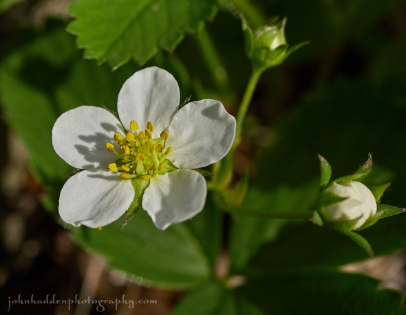
Wild strawberry in bloom
Morning Observation:
This morning in Huntington at 7:30AM it’s currently 52 degrees under clear skies. Winds are calm. Relative humidity is 99%, dewpoint 52, barometric pressure 29.98” and rising slowly. We picked up 0.37” of rain in the past 24hrs. Yesterday’s high was 73, and the overnight low was 42.
Forecast:
High pressure will bring dry conditions with clear to partly cloudy skies and above normal temperatures today. An area of low pressure will lift northwards towards the New England coastline bringing increasing clouds and a chance for showers on Tuesday. High pressure will build into the region later in the week
bringing Summer-like weather with warm temperatures and a chance for afternoon showers and thunderstorms.
We’ll see sunny skies this morning, then partly sunny skies later in the day. Highs will be in the upper 70s with light and variable winds, becoming northerly around 10 mph this afternoon. Tonight shoul be mostly clear until midnight, then become partly cloudy. Lows will be in the lower 50s with north winds around 10 mph until midnight, becoming light and variable.
Tuesday should be partly sunny with a 40% chance of showers mainly in the afternoon. Highs will be in the upper 70s with light and variable winds. Tuesday night should be partly cloudy with lows in the mid 50s and light and variable winds.
Wednesday’s looking partly sunny with a 30% chance of showers. Highs will be in the upper 70s with west winds around 10 mph. Wednesday night should be partly cloudy with lows in the lower 50s.
Almanac:
Last year on this date we had a high of 61 and a low of 28.
Burlington averages for this date are highs of 69 and lows of 48.
The record high was 91°F in 1975.
The record low was 31°F in 1935.
Sky Notes:
Sunrise: 5:16 AM EDT
Sunset: 8:21 PM EDT
Length of Visible Light: 16h 13m
Length of Day: 15h 04m
Tomorrow will be 1m48s longer.
The Moon is waning gibbous, 16d 16h old with 98% illumination.
Moonrise: 9:52 PM EDT
Moonset: 6:50 AM EDT
About Today’s Photo:
Wild strawberry is flowering prodigiously along the paths by Fargo Brook. Looks like a good year for these little jewels!
Panasonic GX8, Lumix 30mm macro lens, ISO 640, f/5.6, 1/1600″ exposure.
Sunday, May 22, 2016
Foam flower blooming across Fargo Brook
Morning Observation:
This morning in Huntington at 7:30AM it’s currently 53 degrees and drizzling lightly under overcast skies. Winds are calm. Relative humidity is 97%, dewpoint 52 barometric pressure 29.86” and rising slowly. We picked up a 0.01” trace of rain overnight. Yesterday’s high was 76, and the overnight low was 52.
Forecast:
Scattered showers will be possible this afternoon aa low pressure off the coast of the Delmarva Peninsula slowly pushes northeastward towards the New England coastline. We’ll see cloudy skies this morning with a slight chance of thunderstorms. Showers will be likely this afternoon. Highs will be around 70 with light and variable winds, becoming northerly around 10 mph this afternoon. Chance of rain is 60%. Tonight should be mostly cloudy with a 50% chance of showers and a slight chance of thunderstorms until midnight, then become partly cloudy after midnight. Lows will be around 50 with northeast winds around 10 mph until midnight, becoming light and variable.
Monday should be mostly sunny with highs in the mid 70s and light and variable winds becoming northerly around 10 mph in the afternoon. Monday night should be mostly clear with lows in the lower 50s and northeast winds around 10 mph.
Tuesday’s looking partly sunny with a 50% chance of showers. Highs will be in the mid 70s with light and variable winds. Tuesday night should be partly cloudy with a 50% chance of showers. Lows will be in the mid 50s.
Almanac:
Last year on this date we had a high of 58 and a low of 40.
Burlington averages for this date are highs of 69 and lows of 47.
The record high was 93°F in 1977.
The record low was 31°F in 1936.
Sky Notes:
Sunrise: 5:17 AM EDT
Sunset: 8:20 PM EDT
Length of Visible Light: 16h 11m
Length of Day: 15h 02m
Tomorrow will be 1m52s longer.
The Moon is waning gibbous, 15d 16h old with near 100% illumination.
Moonrise: 8:58 PM EDT
Moonset: 6:08 AM EDT
About Today’s Photo:
Delicate foam flower are in bloom now in the woods. We’ve got a nice batch of foam flowers across Fargo Brook.
Panasonic GX8, Lumix 30mm macro lens, ISO 640, f/5.6, 1/1600″ exposure.
Saturday, May 21, 2016
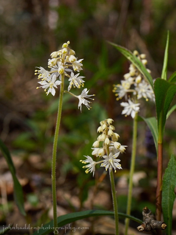
Broadleaf toothwort blooming along Fargo Brook
Morning Observation:
This morning in Huntington at 6:45AM it’s currently 45 degrees under mostly clear skies. Winds are calm. Relative humidity is 98%, dewpoint 45, barometric pressure 30.11”. Yesterday’s high was 74, and the overnight low was 43.
Forecast:
High pressure continues today as an upper level trough approaching from the Ohio River Valley will bring increasing cloud cover during the day. The threat for showers will increase this evening with the highest threat on Sunday as the surface low moves through. Temperatures will to continue to be above average through the weekend with highs in the low to mid 70s and overnight lows in the upper 40s to lower 50s.
We’ll see partly sunny skies this morning, then mostly cloudy skies this afternoon. Highs will be in the mid 70s with light and variable winds, becoming southwesterly around 10 mph this afternoon. Tonight should be mostly cloudy with a 20% chance of showers. Lows will be in the lower 50s with light and variable winds.
Sunday should be mostly cloudy with a chance of showers in the morning, then showers likely with a slight chance of thunderstorms in the afternoon. Highs will be in the upper 60s with light and variable winds, becoming northwesterly around 10 mph in the afternoon. Chance of rain is 70%. Sunday night should be partly cloudy with a 50% chance of showers. Lows will be around 50 with light and variable winds.
Monday’s looing mostly sunny with highs in the mid 70s and north winds around 10 mph. Monday night should be mostly clear with lows in the lower 50s.
Almanac:
Last year on this date we had a high of 67 and a low of 34.
Burlington averages for this date are highs of 69 and lows of 47.
The record high was 92°F in 1911.
The record low was 29°F in 1964.
Sky Notes:
Sunrise: 5:18 AM EDT
Sunset: 8:19 PM EDT
Length of Visible Light: 16h 09m
Length of Day: 15h 00m
Tomorrow will be 1m53s longer.
The Moon is the full “Flower” moon (Northeast Native American)
14d 15h old with 100% illumination.
Moonrise: 8:03 PM EDT
Moonset: 5:30 AM EDT
Other names for this month’s full moon include: “Milk” (Colonial American, English), “Bright” (Celtic), “Hare” (Medieval Wiccan), and “Grass” (Neo Pagan Wiccan).
About Today’s Photo:
The spring flower cavalcade continues! Broadleaf toothwort is a regular in certain places along Fargo Brook.
Panasonic GX8, Lumix 30mm macro lens, IOS 640, f/5.6, 1/2000″ exposure.
Friday, May 20, 2016

Marsh marigold blooming near Fargo Brook
Morning Observation:
This morning in Huntington at 7:00AM it’s currently 41 degrees under mostly clear skies. Winds are calm. Relative humidity is 98%, dewpoint 41, barometric pressure 30.21” and rising. Yesterday’s high was 69, and the overnight low was 38.
Forecast:
A ridge of high pressure will be over the region today through early Saturday, bringing dry weather and above normal temperatures. An upper level low will bring a chance of showers late Saturday through Sunday night.
We’ll see sunny skies today with highs in the mid 70s and light and variable winds, becoming northwesterly around 10 mph this afternoon. Tonight should be clear with lows in the upper 40s and light and variable winds.
Saturday should be partly sunny in the morning, then become cloudy as the aforementioned low approaches from the Ohio River Valley. Highs will be in the mid 70s with light and variable winds, becoming southwesterly around 10 mph in the afternoon. Saturday night should be cloudy with lows in the lower 50s and south winds around 10 mph.
Sunday’s looking cloudy with a 50% chance of showers. Highs will be around 70 with light and variable winds. Sunday night showers are likely. Lows will be around 50. Chance of rain is 60%.
Almanac:
Last year on this date we had a high of 56 and a low of 47. We picked up 0.01″ of rain.
Burlington averages for this date are highs of 69 and lows of 47.
The record high was 91°F in 1975.
The record low was 30°F in 2002 (we had a low of 27).
Sky Notes:
Sunrise: 5:19 AM EDT
Sunset: 8:18 PM EDT
Length of Visible Light: 16h 07m
Length of Day: 14h 58m
Tomorrow will be 1m57s longer.
The Moon is waxing gibbous, 13d 15h old with 98% illumination.
Moonrise: 7:06 PM EDT
Moonset: 4:57 AM EDT
About Today’s Photo:
Marsh marigold is a common flower in this area that grows, as the name implies, in marshy and wet areas along streams and wetlands. The bright yellow flowers are some of the earlier blooms of spring.
Panasonic GX8, Lumix 30mm macro lens, ISO 640, f/4.5, 1/400″ expsosure.
Thursday, May 19, 2016
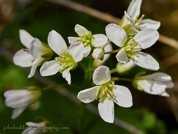
Wood anenome blooming across Fargo Brook
Morning Observation:
This morning in Huntington at 7:45AM it’s currently 47 degrees under mostly cloud skies. Winds are calm. Relative humidity is 93%, dewpoint 45, barometric pressure 30.10”. Yesterday’s high was 64, and the overnight low was 42.
Forecast:
A warming trend will continue through the weekend with temperatures slightly above normal expected. We’ll see partly sunny skies this morning with a slight chance of showers this morning, then a chance of showers with a slight chance of thunderstorms this afternoon courtesy of an upper level low and pool of cool air aloft. Some thunderstorms may produce small hail this afternoon. Highs will be in the mid 60s with light and variable winds, becoming northwesterly around 10 mph this afternoon. Chance of rain is 40%. Tonight should be partly cloudy. A chance of showers with a slight chance of thunderstorms until midnight. Some thunderstorms may produce small hail until midnight. Lows will be in the lower 40s with light and variable winds. Chance of rain is 30%.
Friday should be sunny with highs in the lower 70s and light and variable winds becoming northwesterly around 10 mph in the afternoon. Friday night should be mostly clear with lows around 50 and light and variable winds.
Saturday’s looking partly sunny with highs in the mid 70s and light and variable winds. Saturday night should be partly cloudy with lows in the upper 40s.
Almanac:
Last year on this date we had a high of 78 and a low of 55. We picked up 0.04″ of rain.
Burlington averages for this date are highs of 68 and lows of 46.
The record high was 91°F in 1989.
The record low was 31°F in 1987.
Sky Notes:
Sunrise: 5:20 AM EDT
Sunset: 8:17 PM EDT
Length of Visible Light: 16h 05m
Length of Day: 14h 56m
Tomorrow will be 1m59s longer.
The Moon is waxing gibbous, 12d 16h old with 95% illumination.
Moonrise: 6:08 PM EDT
Moonset: 4:27 AM EDT
About Today’s Photo:
We’ve got a fine patch of wood anenome blooming just across our bridge over Fargo Brook. The buds sport a lovely pinkish blush before they open up which gradually fades to snow white.
Panasonic GX8, Lumix 30mm macro lens, ISO 640, f/6.3, 1/600″ exposure.
Wednesday, May 18, 2016
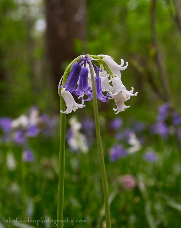
Bluebells blooming in Ohio woods
Morning Observation:
This morning in Huntington at 6:25AM it’s currently 42 degrees under overcast skies. Winds are calm. Relative humidity is 94%, dewpoint[ 41, barometric pressure 30.17”. Yesterday’s high was 64, and the overnight low was 37.
Forecast:
We’ll see variable clouds and temperatures climbing back into the normal range as we head towards the weekend. We’ll see partly sunny skies this morning, then clearing skies later in the afternoon. Highs will be in the mid 60s with light and variable winds. Tonight should be partly cloudy until midnight, then become mostly cloudy. Lows will be in the lower 40s with light and variable winds.
Thursday should be partly sunny with a slight chance of showers in the morning, then a chance of showers with a slight chance of thunderstorms in the afternoon as an upper level trough pivots through. Highs will be in the mid 60s with light and variable winds. Chance of rain is 30%. Thursday night should be partly cloudy with lows in the lower 40s and light and variable winds.
Friday’s looking sunny and warmer with highs in the lower 70s and light and variable winds. Friday night should be mostly clear with lows in the upper 40s.
Almanac:
Last year on this date we had a high of 82 and a low of 49.
Burlington averages for this date are highs of 68 and lows of 46.
The record high was 89°F in 1962.
The record low was 29°F in 1983.
Sky Notes:
Sunrise: 5:21 AM EDT
Sunset: 8:16 PM EDT
Length of Visible Light: 16h 03m
Length of Day: 14h 54m
Tomorrow will be 2m2s longer.
The Moon is a waxing gibbous, 11d 15h old with 90% illumination.
Moonrise: 5:11 PM EDT
Moonset: 3:59 AM EDT
About Today’s Photo:
Bluebells (and their white variety) are “old world” flowers that have naturalized to much of the northeast US. They’re quite common around my Mom’s place in northeast Ohio popping up frequently in woodlands where they can carpet an area.
Panasonic GX8, Lumix 14-140mm lens @ 40mm, ISO 400, f/6.3, 1/30″ exposure.
Tuesday, May 17, 2016
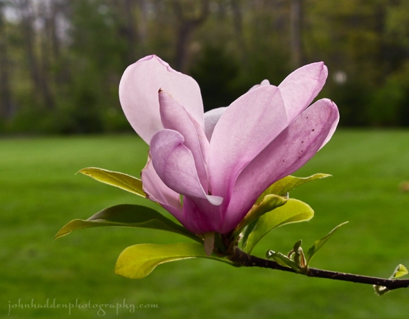
A purple magnolia blooming in my mother’s yard in northeast Ohio
After a long hiatus of travel and family obligations out in Ohio, I’m finally back to lovely Vermont!
Morning Observation:
This morning in Huntington at 7:55AM it’s currently 46 degrees under partly cloudy skies. Winds are calm. Relative humidity is 70%, dewpoint 37, barometric pressure 30.13” and rising slowly. We picked up 0.03” of rain in the past 24hrs. Yesterday’s high was 47, and the overnight low was 31.
Forecast:
Cool temperatures will continue courtesy of high pressure currently building into the region. We’ll see mostly sunny skies today with highs in the upper 50s and northwest winds 10 to 15 mph. Tonight should be mostly clear with lows in the upper 30s and north winds around 10 mph until midnight, becoming light and variable.
Wednesday should be partly sunny with highs in the upper 50s and light and variable winds, becoming northwesterly around 10 mph in the afternoon. Wednesday night should be partly cloudy with lows in the lower 40s and northwest winds around 10 mph.
Thursday’s looking mostly sunny and more seasonable with highs in the lower 60s and light and variable winds. Thursday night should be clear with lows in the mid 40s.
Almanac:
Last year on this date we had a high of 77 and low of 50. We picked up 0.01″ of rain.
Burlington averages for this date are highs of 68 and lows of 46.
The record high was 90°F in 1977.
The record low was 29°F in 1957.
Sky Notes:
Sunrise: 5:22 AM EDT
Sunset: 8:15 PM EDT
Civil Twilight 4:48 AM EDT 8:49 PM EDT
Length of Visible Light: 16h 00m
Length of Day: 14h 52m
Tomorrow will be 2m5s longer.
The Moon is waxing gibbous, 10d 16h old with 84% illumination.
Moonrise: 4:13 PM EDT
Moonset: 3:31 AM EDT
About Today’s Photo:
One of the reasons for my long absence was to move my mother from her home of 30 years to a continuing care apartment in Ohio (a planned move). The purple magnolia in her yard was in full bloom while there (despite the snow that fell on Sunday!) so, while not a Vermont scene, I figured you all might appreciate it.
Sunday, May 15, 2016: Ohio snow

A little visit from the polar vortex brings graupel, sleet, and even a rumble of thundersnow to northeast Ohio this morning.
Back to Vermont tomorrow!
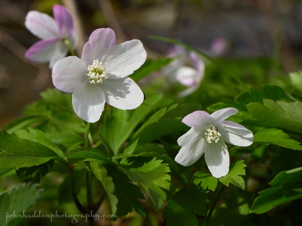
Friday, May 6, 2016: Spring Ephemerals


Greetings Weather Blog friends and followers! You may have wondered where I’ve been for the past month or so. I was on an extended trip that took my recently retired wife, Robin, and I down to the Florida Keys and back! I’m back for a couple days before I have to head out to Ohio to help my mom move. I’ll be back around the 16th, so stay tuned!
|
Anyway, I thought I’d post some photos I took today. We went for a short hike up Mt. Hunger in Waterbury today (dutifully turning around at the “Trail Closed” sign above the waterfall…) I’d thought that, after being away from the Vermont woods for a month, that we’d missed the spring ephemerals. Not so! The trail up the mountain was alive with all the “usual suspects”! In places, the spring beauties covered the forest floor, and their fragrance sweetened the air! What a fine welcome back to the hills of Vermont! Panasonic GM5, 12-32mm lens @ various lengths, various ISOs, apertures, and shutter speeds. |
