Tuesday, February 13, 2024
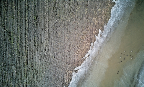 Aerial abstract with ducks
Morning Observation:
This morning in Huntington at 7:20AM it’s currently 30 degrees under cloudy skies. Winds are calm. Relative humidity s 80%, dewpoint 25, barometric pressure 29.69”. We have 3.5” of snow at the stake. Yesterday’s high was 35, and yesterday’s low was 30. The overnight low got down to 30.
This morning in North Hero it’s currently 26 degrees under cloudy skies. Winds are calm. Relative humidity is 96%, dewpoint 25, barometric pressure 29.78”. No snow. Yesterday’s high was 36, and yesterday’s low was 31. The overnight low got down to 26.
Forecast Discussion:
Morning radar imagery shows a deep low pressure system just off the coast of Richmond, Virginia at this hour. The low is expected to track eastward through the day today with only a glancing blow of precipitation falling over far southern Vermont. The rest of us will see dry and seasonably mild conditions today with highs in the mid to upper 30s. Weak shortwave energy will drop into the region overnight tonight bringing the chance of some light snow showers, and we might pick up an inch or so of fluff. Dry, blustery, and seasonably chilly conditions are expected for Wednesday as high pressure builds in briefly. Low pressure tracking out of the Great Lakes on Thursday will bring the chance of some accumulating snow Thursday night into Friday. The NWS is calling for as much as 3″-6″ of fluffy, light snow by Friday morning. Fingers crossed, but I’ll believe it when I’m shoveling it! Unsettled conditions are expected heading into the weekend with seasonably cool temperatures and scattered snow showers expected Saturday. Sunday’s looking dry and partly sunny.
3-Day Forecast:
We’ll see mostly cloudy skies today with a high near 38 and north winds 5-10 mph. Tonight should be mostly cloudy with a 50% chance of snow showers late. Lows will be around 17 with northwest winds 8-13 mph after midnight. New snow accumulations of around 1″ are possible.
Wednesday should be partly sunny with a 30% chance of snow showers. Highs will be near 24 with northwest winds 14-18 mph. New snow accumulations of less than 0.50″ are possible. Wednesday night should be partly cloudy with a low around 15 and northwest winds 10-17 mph.
Thursday should bring increasing clouds with a 30% chance of snow after 5:00PM. Highs will be near 29 with northwest winds 5-7 mph becoming southerly in the afternoon. Little or no snow accumulation is expected. Thursday night should be cloudy with snow. Lows will be around 22 with southeast winds 5-11 mph becoming westerly after midnight. Chance of precipitation is 90% with 2″-4″ of new snow possible.
Almanac:
Last year on this date in Huntington we had a high of 47 and a low of 21. We had 5″ of snow at the stake.
Last year in North Hero we had a high of 41 and a low of 21. We had 2″ of snow at the stake.
Burlington averages for this date are a low of 14 and a high of 31.
The record low was -25 in 1967.
The record high was 53 in 1984.
The Lake Champlain lake level in Burlington is 97.09′.
The water temperature is 37˚.
Last year’s lake level was at 96.27′.
The Mt. Mansfield snow stake depth is 46″.
The average depth for this date is 57″.
Mt. Washington Summit Conditions
Current Temperature: 8˚
Winds are out of the west at 8-12 mph
24 hr Precipitation: 0.2″ snow, 0.02″ melted precipitation
Visibility: less than 1/16 mile in freezing fog
Sky Notes:
Sunrise: 6:55AM
Sunset: 5:17PM
Length of day: 10:22:31
Today will be 2:48 longer than yesterday.
The Moon is a waxing crescent, 4 days old with 16% illumination.
Moonrise: 8:54AM
Moonset: 10:19PM
About Today’s Photo:
Fallow corn fields along the River Road between Richmond and Essex Jct offer an opportunity to explore composition and texture from above. A wet swale provided a nice pool for a group of ducks to cavort in.
DJI Mini 3 drone, ISO 100, f/1.7, 1/1600″ exposure

Leave a comment