Sunday, February 18, 2024
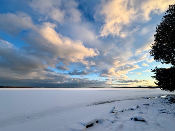 Clearing skies and snow covered ice in North Hero
Morning Observation:
This morning in Huntington at 7:25AM it’s currently 15 degrees under cloudy skies. Winds are calm. Relative humidity is 84%, dewpoint 11, barometric pressure 29.73”. We picked up 3.5” of new snow during the day yesterday and have 10” at the stake. Yesterday’s high was 26, and yesterday’s low was 11. The overnight low got down to 4.
This morning in North Hero it’s currently 19 degrees under cloudy skies. Winds are out of the south at 15-16 mph. Relative humidity is 84%, dewpoint 15, barometric pressure 29.79”. We have 3” of snow at the stake. Yesterday’s high was 32, and yesterday’s low was 13. The overnight low got down to 12.
Forecast Discussion:
An Arctic boundary will drop into the region later this evening/overnight bringing a quick round of snow showers with some embedded snow squalls overnight. We may pick up an inch or two here in Huntington. Cool and dry air will move in behind the front bringing a stretch of seasonable, dry, and mostly sunny weather for the first part of the week under building high pressure. A warming trend is expected to develop by midweek with highs on Wednesday and Thursday pushing into the mid 40s. Our next storm system will arrive sometime later Thursday into Friday bringing another round of mixed precipitation to the region. It’s still too far out to get an exact bead on precipitation types and amounts, but at this point it’s not looking like a washout. Colder air is expected to move in behind the system. Stay tuned…
3-Day Forecast:
We’ll see mostly cloudy skies today with a 20% chance of snow showers. Highs will be near 29 with southwest winds 10-16 mph. Tonight should be mostly cloudy with a 50% chance of snow showers. Lows will be around 14 with southwest winds 11-16 mph becoming northwesterly after midnight. New snow accumulations of less than 1″ are possible.
Monday should be sunny with a high near 23 and northwest winds 9-11 mph. Monday night should be mostly clear and chilly with a low around 8 and northwest winds 5-7 mph becoming calm after midnight.
Tuesday should be sunny with a high near 31 and light and variable winds. Tuesday night should be partly cloudy with a low around 16 and southeast winds around 6 mph in the evening.
Almanac:
Last year on this date in Huntington we had a high of 31 and a low of 6. We picked up 1.5″ of new snow and had 4.5″ at the stake.
Last year in North Hero we had a high of 34 and a low of 12. We picked up 1″ of new snow and had 1″ at the stake.
Burlington averages for this date are highs of 15 and a high of 32.
The record low was -25 in 1979.
The record high was 58 in 1981.
The Lake Champlain lake level in Burlington is 96.80′.
The water temperature is 35˚.
Last year’s lake level was at 96.42′.
The Mt. Mansfield snow stake depth is 61″.
The average depth for this date is 61″.
Mt. Washington Summit Conditions
Current Temperature: -8˚
Winds are out of the north at 58-61 mph
24 hr Precipitation: 2.9″ snow, 0.25″ melted precipitation
Visibility: around 1/16 mile in freezing fog and blowing snow
Sky Notes:
Sunrise: 6:47AM
Sunset: 5:24PM
Length of day: 10:36:50
Today will be 2:53 longer than yesterday.
The Moon is waxing gibbous, 9 days old with 67% illumination.
Moonrise: 11:28AM
Moonset: 3:17AM
About Today’s Photo:
The weather in North Hero was very different yesterday than it was here in Huntington. While Huntington experienced some persistent snow showers during the day, North Hero enjoyed a mostly sunny day with gusty west winds—perfect for Great Ice festivities! We could see the snow falling over the mountains during the day. Such is the weather in Vermont.
iPhone 15 Pro

Leave a comment