Friday, February 23, 2024
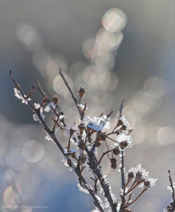 Frost crystals form flowers on dried seed head
Morning Observation:
This morning in Huntington at 7:30AM it’s currently 36 degrees under cloudy skies. Winds are calm. Relative humidity is 94%, dewpoint 34, barometric pressure 29.92”. We picked up 0.05” of rain yesterday and 0.08” so far today. We have 6” of snow at the stake. Yesterday’s high was 44, and yesterday’s low was 32. The overnight low got down to 34.
This morning in North Hero it’s currently 35 degrees under cloudy skies. Winds are out of the south at 10-15 mph. Relative humidity is 95%, dewpoint 34, barometric pressure 29.55”. We picked up 0.01” of rain yesterday and are down to bare ground at the stake. Yesterday’s high was 37, and yesterday’s low was 32. The overnight low got down to 35.
Forecast Discussion:
Morning radar imagery shows a line of rain and snow showers extending along a stalled occluded front stretching from about NYC, up through central Vermont, and into Maine. This frontal boundary is expected to creep southeastward today bringing any remaining showers to an end during the day. Highs today will top out in the low to mid 40s. A sharp cold front is expected to cross the region overnight tonight causing temperatures to plummet from their afternoon highs into the single digits and low teens by daybreak on Saturday. Some snow showers way accompany the frontal passage overnight. Some of the coldest air of the season will move in behind the front for Saturday on a ridge of high pressure with daytime highs only expected to be in the low to mid teens and overnight lows dropping into the single digits Saturday night with gusty northwest winds. The cold air won’t be with us long, however, as the ridge moves to our east allowing for a southerly return flow to set up Sunday bringing in milder air with highs in the mid 30 expected for Sunday. A weak trough will swing through Sunday night into Monday bringing a chance of some light snow showers, but the warming trend will continue with highs expected to be in around 40 on Monday, 50 and Tuesday, and approaching 60 by Wednesday. A more significant storm system is expected to develop in the Wednesday/Thursday timeframe as a “full latitude” trough (one that stretches all the way from southern latitudes to northern latitudes) crosses the region bringing widespread rain. Stay tuned…
3-Day Forecast:
We’ll see mostly cloudy skies today with a slight chance of morning snow showers, then a slight chance of evening rain showers. Highs will be near 45 with south winds 5-12 mph. Tonight should be mostly cloudy with a 50 percent% chance of snow showers. Lows will be around 9 with north winds 8-16 mph. New snow accumulations of less than 0.50″ are possible.
Saturday should be mostly sunny and chilly with a high near 16 and northwest winds 14-17 mph. Saturday night should be mostly clear with a low around 6 and northwest winds 6-11 mph becoming light and variable after midnight.
Sunday should be mostly sunny with a high near 33 and south winds 5-10 mph. Sunday night should be cloudy with a 50% chance of snow showers. Lows will be around 28 with south winds around 11 mph.
Almanac:
Last year on this date in Huntington we had a high of 25 and a low of 19. We picked up 4.7″ of new snow and had 7.5″ at the stake.
Last year in North Hero we had a high of 20 and a low of 14. We picked up 4″ of new snow and had 4″ at the stake.
Burlington averages for this date are a low of 16 and a high of 34.
The record low was -22 in 1972.
The record high was 63 in 2017 (we had a high of 64 in Huntington).
The Lake Champlain lake level in Burlington is 96.46′.
The water temperature is 35˚.
Last year’s lake level was at 96.44′.
The Mt. Mansfield snow stake depth is 60″.
The average depth for this date is 61″.
Mt. Washington Summit Conditions
Current Temperature: 25˚
Winds are out of the NE at 11-13 mph
24 hr Precipitation: 1.2″ snow, 0.13″ melted precipitation
Visibility: less than 1/16 mile in freezing fog
Sky Notes:
Sunrise: 6:39AM
Sunset: 5:31PM
Length of day: 10:51:32
Today will be 2:57 longer than yesterday.
The Moon is waxing gibbous, 13.7 days old with 98% illumination.
Moonrise: 4:42PM
Moonset: 6:40AM
About Today’s Photo:
Here’s another shot from our glittery chilly morning the other day. Frost crystals have formed almost flower-like shapes on the dried seed head of a shrub by our pond. I meant to mention yesterday that we coincidentally visited the Snowflake Bentley Museum in Jericho the other day. I’d never been before and it was wonderful to learn a bit about this pioneering photographer and see some of is amazing prints of snowflakes.
Sony A7II, Sony 90mm macro lens, ISO 400, f/5.6, 1/250″ exposure

The land our family owned and lived on for 43 years meets the Old Red Mill property. I love living here, but still miss my deep rooted community in Jericho. I was so involved in so many things. But as I said, I love living in this cottage up on Ross Hill.
February 23, 2024 at 8:21 am