Monday, February 12, 2024
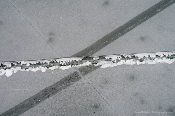 A history of cracks in sheet ice
Morning Observation:
This morning in Huntington at 7:35AM it’s currently 32 degrees under cloudy skies. Winds are calm. Relative humidity is 89%, dewpoint 29, barometric pressure 29.92”. We have 3.5” of snow at the stake. Yesterday’s high was 42, and yesterday’s low was 33.
This morning in North Hero it’s currently 34 degrees under cloudy skies. Winds are calm. Relative humidity is 82%, dewpoint 29, barometric pressure 29.95”. No snow. Yesterday’s high was 41, and yesterday’s low was 35. The overnight low got down to 33.
Forecast Discussion:
Dry and seasonably mild conditions will be with us again today as highs top out in the mid 30s and morning clouds give way to some glimpses of sun this afternoon. Current forecast models show the coastal storm I’ve been talking about over the past couple of days tracking south and east of the Cape Cod benchmark on Tuesday. This means there will be even less snow in Vermont with current estimates of 1″-3″ of snow over southern Vermont instead of the 3″-6″ previously forecast. Nuthin’ up here in Huntington from this system. However, a weak shortwave is expected to swing through Tuesday night bringing some light snow. Dry and seasonable conditions are expected through the middle of the week. The next chance of precipitation arrives overnight Thursday as low pressure swings out of the Great Lakes and through the North Country. There’s not a whole lot of moisture to work with in this system so snowfall is expected to be minimal. Seasonable conditions are expected heading into the weekend with the chance of some light snow showers Saturday and Sunday.
3-Day Forecast:
We’ll see mostly cloudy skies today with a high near 36 and west winds 5-7 mph in the morning. Tonight should be mostly cloudy with a low around 26 and northeast winds around 5 mph.
Tuesday should be cloudy with a slight chance of light snow. Highs will be near 33 with north winds 7-15 mph. Tuesday night should be mostly cloudy with a 40% chance of snow showers. Lows will be around 18 with northwest winds 8-10 mph. New snow accumulations of less than 1″ are possible.
Wednesday should be partly sunny with a high near 24 and northwest winds 14-17 mph. Wednesday night should be partly cloudy with a low around 15 and northwest winds 11-18 mph.
Almanac:
Last year on this date in Huntington we had a high of 43 and a low of 20. We had 5″ of snow at the stake.
Last year in North Hero we had a high of 38 and a low of 26. We had 2″ of snow at the stake.
Burlington averages for this date are a low of 13 and a high of 31.
The record low was -30 in 1979.
The record high was 56 in 1999.
The Lake Champlain lake level in Burlington is 97.10′.
The water temperature is 37˚.
Last year’s lake level was at 96.20′.
The Mt. Mansfield snow stake depth is 46″.
The average depth for this date is 57″.
Mt. Washington Summit Conditions
Current Temperature: 16˚
Winds are out of the NW at 40 mph
24 hr Precipitation: 0
Visibility: over 100 miles under clear skies
Sky Notes:
Sunrise: 6:56AM
Sunset: 5:16PM
Length of day: 10:19:42
Today will be 2:47 longer than yesterday.
The Moon is a waxing crescent, 2.7 days old with 8% illumination.
Moonrise: 8:33AM
Moonset: 9:00PM
About Today’s Photo:
Sheet ice offers an ever-changing canvas of shapes and forms. The ice is a living thing, flexing under the force of wind and sun to crack, pull apart, draw back together, melt and refreeze. This shot offers a glimpse of this cryogenic geology where several cracks have formed, shifted, and refrozen. If you look carefully, you can see tiny frost feather along the broad horizontal crack indicative of moisture leaching up from below.
Sony A7II, Sony 24-240mm lens @ 35mm, ISO 800, f/16, 1/50″ exposure

Very cool ! Abstract.
February 12, 2024 at 10:16 am
Thanks LJ! And now I know you’re real first name!
February 12, 2024 at 10:42 am