Sunday, April 21, 2024
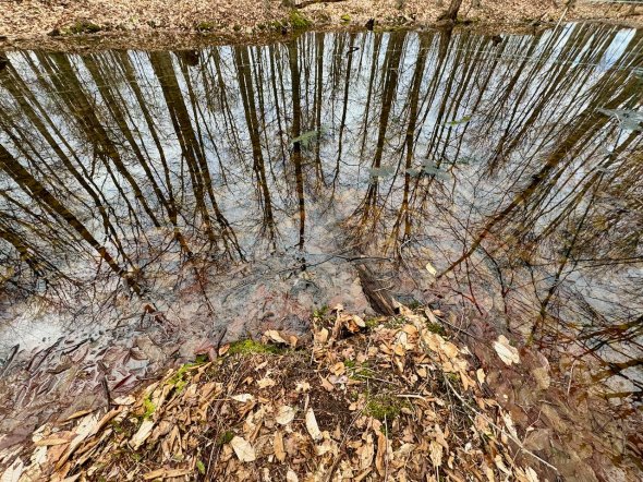 A calm vernal pool in the East Street woods
Morning Observation:
This morning in Huntington at 7:55AM it’s currently 35 degrees under partly cloudy skies. Winds are calm. Relative humidity is 93%, dewpoint 33, barometric pressure 29.96”. We picked up 0.01” of rain yesterday. Yesterday’s high was 58, and yesterday’s low was 34. The overnight low got down to 29.
This morning in North Hero it’s currently 41 degrees under partly cloudy skies. Winds are out of the southwest at 3-5 mph. Relative humidity is is 70%, dewpoint 32, barometric pressure 29.97”. We picked up 0.02” of rain yesterday. Yesterday’s high was 53, and yesterday’s low was 41. The overnight low got down to 38.
Forecast Discussion:
We’ve got a bit of a roller-coaster ahead of us for the coming week. A ridge of high pressure will bring dry and seasonably cool conditions today through most of Monday. A cold front is expected to cross the region tonight with little fanfare, but much cooler conditions are expected for Monday with highs only in the mid 40s to around 50. Winds are expected to turn into the south on Tuesday allowing warmer air to move with highs expected to bump into the upper 50s to low 60s. Our next storm system arrives later Tuesday night. Temperatures are expected to drop back into the 40s Wednesday with rain likely. Below freezing temperatures Wednesday night will likely bring some wet snow overnight with some moderate accumulations possible over higher elevations. Dry but chilly conditions return Thursday as high pressure builds back in to finish out the week with temperature slowly recovering to more seasonable levels.
3-Day Forecast:
We’ll see mostly sunny skies today with a high near 50 and west winds 6-11 mph. Tonight should be partly cloudy with a slight chance of rain and snow showers. Lows will be around 28 with west winds 9-11 mph.
Monday should be sunny with a high near 45 and northwest winds around 10 mph. Monday night should be clear with a low around 31 and south winds 3-8 mph.
Tuesday should be mostly sunny with a high near 61 and south winds 10-14 mph. Tuesday night should be mostly cloudy with showers likely mainly after 3:00AM. Lows will be around 42 with south winds 11-13 mph. Chance of precipitation is 70% with rainfall amounts of less than 0.10″ possible.
Almanac:
Last year on this date in Huntington we had a high of 76 and a low of 36.
Last year in North Hero we had a high of 61 and a low of 40.
Burlington averages for this date are a low of 38 and a high of 58.
The record low was 23 in 1981.
The record high was 83 in 1987.
The Lake Champlain lake level in Burlington is 98.63′.
The water temperature is 42˚.
Last year’s lake level was at 98.05′.
The Mt. Mansfield snow stake depth is 60″.
The average depth for this date is 62″.
Mt. Washington Summit Conditions
Current Temperature: 17˚
Winds are out of the west at 26-28 mph
24 hr Precipitation: 1.5″ snow and 0.26″ melted precipitation
Visibility: about 1/16 mile in freezing fog
Sky Notes:
Sunrise: 5:57AM
Sunset: 7:44PM
Length of day: 13:47:03
Today will be 2:51 longer than yesterday.
The Moon is waxing gibbous, 12.3 days old with 93% illumination.
Moonrise: 5:34PM
Moonset: 5:00AM
About Today’s Photo:
There’s a persistent vernal pool at the top of the East Street woods hill that’s a reliable place to find critters this time of year. We didn’t see anything moving the other day, but you can clearly see some wood frog eggs on the surface.
iPhone 15 Pro

Leave a comment