Saturday, April 13, 2024
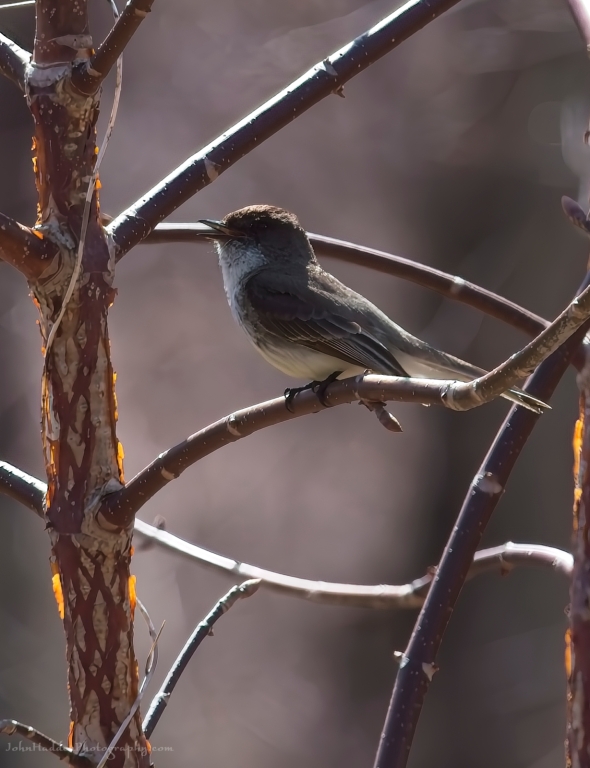 A phoebe in mid-call
Morning Observation:
This morning in Huntington at 7:10AM it’s currently 45 degrees under mostly cloudy skies. Winds are calm. Relative humidity is 87%, dewpoint 41, barometric pressure 29.32”. We picked up 0.51” of rain yesterday and 0.09” so far today. Yesterday’s high was 71, and yesterday’s low was 51. The overnight low got down to 45.
This morning in North Hero it’s currently 45 degrees under mostly cloudy skies. Winds are out of the south at 3-5 mph. Relative humidity is 89%, dewpoint 42, barometric pressure 29.33. We picked up 0.78” of rain yesterday and 0.06” so far today. Yesterday’s high was 61, and yesterday’s low was 45. The overnight low got down to 45.
Forecast Discussion:
Morning radar imagery shows deep low pressure to our north just south of James Bay. This low will continue to rotate showers into the region today and into early Sunday. Highs today will be much cooler than yesterday—in the upper 40s to low 50s—but with lighter winds. After a brief lull in precipitation midday Sunday, another trough is expected to swing through to the north bringing showers later Sunday afternoon into Sunday night. High pressure will build in briefly Monday night into Tuesday before low pressure moving into the Great Lakes brings more rain for later int the week.
3-Day Forecast:
We’ll see mostly cloudy skies today with showers likely mainly after 2:00PM. Highs will be near 48 with south winds 10-15 mph. Chance of precipitation is 80% with rainfall amounts of less than 0.10″ possible. Tonight should be cloudy with showers, mainly before 11:00PM. Lows will be around 36 with west winds 15-20 mph. Chance of precipitation is 80% with rainfall amounts between 0.10″-0.25″ possible.
Sunday should be mostly cloudy with showers likely, mainly after 4:00PM. Highs will be near 55 with west winds 8-10 mph. Chance of precipitation is 60% with rainfall amounts of less than 0.10″ possible. Sunday night should be mostly cloudy with showers likely, mainly before 9:00PM. Lows will be around 38 with south winds around 6 mph becoming light and variable. Chance of precipitation is 60% with rainfall amounts of less than 0.10″ possible.
Monday should be partly sunny with a high near 56 and west winds 6-10 mph. Monday night should be partly cloudy with a low around 38 and southwest winds around 7 mph.
Almanac:
Last year on this date in Huntington we had a high of 87(!) and a low of 41.
Last year in North Hero we had a high of 81 and a low of 41.
Burlington averages for this date are a low of 35 and a high of 54.
The record low was 20 in 2000 (we had a low of 16 in Huntington).
The record high was 88 in 2023 (see above).
The Lake Champlain lake level in Burlington is 98.31′.
The water temperature is 41˚.
Last year’s lake level was at 97.89′.
The Mt. Mansfield snow stake depth is 70″ (as of 4/11).
The average depth for this date is 70″.
Mt. Washington Summit Conditions
Current Temperature: 28˚
Winds are out of the south at 38 gusting to 48 mph
24 hr Precipitation: 1.38″ rain
Visibility: about 1/16 mile in freezing fog
Sky Notes:
Sunrise: 6:10AM
Sunset: 7:34PM
Length of day: 13:23:51
Today will be 2:57 longer than yesterday.
The Moon is a waxing crescent, 5 days old with 25% illumination.
Moonrise: 9:04AM
Moonset: 12:58AM
About Today’s Photo:
Spring is coming on strong here in Huntington, and the number of different bird calls in the morning is quite amazing! The phoebes have returned as well and this noisy little fellow was making his presence known with his distinctive “feeee-bee!” call.
Sony A7II, Sigma 100-400mm lens @ 400mm, ISO 640, f/10, 1/500″ exposure

Leave a comment