Friday, April 19, 2024
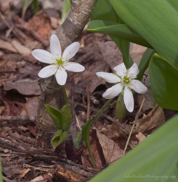 A pair of hepatica blossoms nestled in some ramps
Morning Observation:
This morning in Huntington at 7:55AM it’s currently 44 degrees under cloudy skies. Winds are calm. Relative humidity is 85%, dewpoint 40, barometric pressure 30.10”. We picked up 0.19” of rain yesterday and 0.01” so far today. Yesterday’s high was 52, and yesterday’s low was 41. The overnight low got down to 41.
This morning in North Hero it’s currently 45 degrees under cloudy skies. Winds are out of the south at 12-14 mph. Relative humidity is 85%, dewpoint 41, barometric pressure 30.09”. We picked up 0.29” of rain yesterday. Yesterday’s high was 48, and yesterday’s low was 41. The overnight low got down to 44.
Forecast Discussion:
Unsettled conditions will continue today and into Saturday. Morning radar imagery shows low pressure north of the Great Lakes and a secondary low just about over western Lake Erie with showers pushing eastward. After a dry start to the day, chances for showers will be on the increase midday into this afternoon as a cold front crosses the region. Highs today are expected to climb into the mid 50s to low 60s with gusty south winds. A shortwave trough will swing through to our north on Saturday bringing additional chances for scattered showers, most likely along the international border. Drier air will move in for Sunday with partly sunny skies and highs in the low 50s expected. Temperatures will do a bit of a roller-coaster next week with highs on Monday only in the 40s, then bumping into the upper 50s to low 60s on Tuesday. A strong cold front is expected to move through Tuesday night into Wednesday bringing showers and dropping daytime highs back into the 40s Thursday. Warmer air returns later in the week.
3-Day Forecast:
We’ll see mostly cloudy skies today with a 20% chance of afternoon showers. Highs will be near 58 with south winds 9-14 mph in Huntington and 20-24 mph in the Champlain Valley. Tonight should be mostly cloudy with a 40% chance of showers. Lows will be around 42 with south winds 8-18 mph gusting to 28 mph. Raifnall amounts of less than 0.10″ are possible.
Saturday should be partly sunny with a 20% chance of afternoon showers. Highs will be near 52 with west winds 7-14 mph. Saturday night should be partly cloudy with a low around 33 and west winds 6-9 mph.
Sunday should be mostly sunny with a high near 52 and west winds 7-14 mph. Sunday night should be partly cloudy with a low around 31 and southwest winds around 14 mph.
Almanac:
Last year on this date in Huntington we had a high of 44 and a low of 34. We picked up 0.01″ of rain.
Last year in North Hero we had a high of 46 and a low of 37.
Burlington averages for this date are a low of 37 and a high of 57.
The record low was 23 in 1961.
The record high was 91 in 1976.
The Lake Champlain lake level in Burlington is 98.70′.
The water temperature is 41˚.
Last year’s lake level was at 98.20′.
The Mt. Mansfield snow stake depth is 62″.
The average depth for this date is 62″.
Mt. Washington Summit Conditions
Current Temperature: 31˚
Winds are out of the SW at 13-16 mph
24 hr Precipitation: 0.1″ snow, 0.04″ melted precipitation
Visibility: about 1/16 mile in freezing fog
Sky Notes:
Sunrise: 6:00AM
Sunset: 7:42PM
Length of day: 13:41:20
Today will be 2:52 longer than yesterday.
The Moon is waxing gibbous, 10.5 days old with 81% illumination.
Moonrise: 3:32PM
Moonset: 4:31AM
About Today’s Photo:
On our walk the other day, we came across a few hepatica on the hillside. These look like the sharp-lobed variety as the fuzzy leaves seem to have a defined point to them. You’ll find hepatica colored white like these, but we also found some blush-pink blossoms as well. Note the broad green leaves of ramps around the flowers.
Panasonic GX8, Olympus 60mm macro lens, ISO 800, f/16, 1/160″ exposure

Leave a comment