Tuesday, July 25, 2023
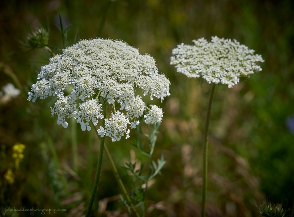 Queen Anne’s lace in its summer glory!
Morning Observation:
This morning in North Hero at 6:50AM it’s currently 69 degrees under partly cloudy skies. Winds are out of the south at 5-7 mph. Relative humidity is 93%, dewpoint 67, barometric pressure 29.99”. We picked up 0.01” of rain yesterday. Yesterday’s high was 80, and yesterday’s low was 68. The overnight low got down to 69.
This morning in Huntington it’s currently 60 degrees under partly cloudy skies. Winds are calm. Relative humidity is 98%, dewpoint 59, barometric pressure 30.04”. We picked up 0.08” of rain yesterday. Yesterday’s high was 86, and yesterday’s low was 56. The overnight low got down to 59.
Forecast Discussion:
Outside of some widely scattered morning showers, we should enjoy another dry day today with highs in the low 80s and partly sunny skies. Wednesday is looking much the same but with slightly warmer highs in the mid 80s, a tad more humidity, and a bit o’ Canadian wildfire smoke. Thursday is looking more stormy than it was just yesterday, as a compact low pressure system is expected to track out of the Great Lakes Wednesday night and over the region on Thursday bringing widespread showers and thunderstorms. There will be quite a bit of moisture to work with so we’ll have to keep an eye out for potential flash flooding during the day on Thursday. Once this system moves through, high pressure is expected to move in on Friday bringing in much warmer and humid air. Highs on Friday are expected to push 90 with dewpoints around 60. A weak shortwave trough is expected to move through later Friday afternoon bringing chances for scattered showers and thunderstorms. A strong cold front is expected to move through on Saturday bringing more thunderstorms, but behind that, we’ll likely see a much cooler airmass move in for the latter part of the weekend and heading into early next week.
3-Day Forecast:
We’ll see partly sunny skies today with a high near 81 and south winds 5-9 mph becoming light in the afternoon. Tonight should be partly cloudy with a low around 62 and light south winds.
Wednesday should be mostly sunny with a high near 85 and south winds to 5 to 10 mph in Huntington and 13-17 mph in the Champlain Valley. Wednesday night should be mostly cloudy with a low around 68 and south winds 8-12 mph.
Thursday should be cloudy with a 60% chance of showers and thunderstorms. Highs will be near 82 with south winds 7-11 mph. Rainfall amounts between 0.75”-1” are possible. Thursday night should be mostly cloudy with showers likely and possibly a thunderstorm before 8:00PM, then a chance of showers and thunderstorms late. Lows will be around 65 with west winds 3-6 mph. Chance of precipitation is 60% with rainfall amounts between 0.25″-0.50″ possible.
Almanac:
Last year on this date in Huntington we had a high of 84 and a low of 60. We picked up 1.17″ of rain.
Last year in North Hero we had a high of 82 and a low of 70. We picked up 0.50″ of rain.
Burlington averages for this date are a low of 63 and a high of 83.
The record low was 46 in 1953.
The record high was 97 in 1963.
The Lake Champlain lake level in Burlington is 98.67′ (going down!)
The water temperature is 75˚.
Last year’s lake level was at 95.15′.
Sky Notes:
Sunrise: 5:31AM
Sunset: 8:24PM
Length of day: 14:53:17
Today will be 2:03 shorter than yesterday.
The Moon is a waxing crescent, 6.8 days old with 43% illumination.
Moonrise: 1:20PM
Moonset: 11:53PM
About Today’s Photo:
Queen Anne’s lace is certainly aptly named as I view it as the queen of summer meadows. The harmless perennial pictured here is also known as wild carrot and its root has a tasty, spicy carrot flavor. Other members of the Apiaceae family include a number of nasty species like wild or poison parsnip, and hemlock.
Sony A7II, Sony 24-240mm lens @ 153mm, ISO 800, f/13, 1/1600″ exposure.

Leave a comment