Monday, November 12, 2018
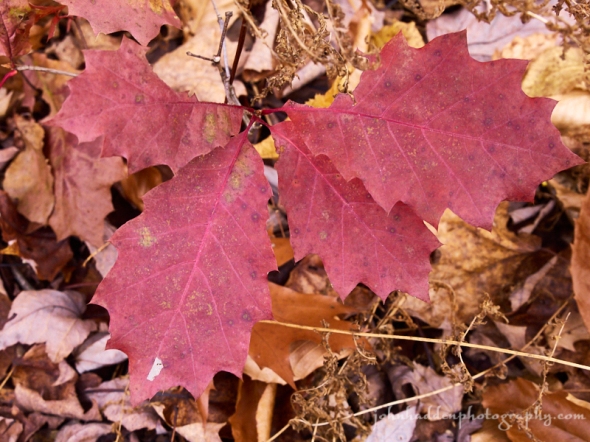
Red oak leaves on the forest floor
Morning Observation:
This morning in Huntington at 7:30AM it’s currently 26 degrees under partly cloudy skies. Winds are calm. Relative humidity is 92%, dewpoint 24, barometric pressure 30.37” and steady. Yesterday’s high was 35, and the overnight low got down to 19.
There is a Winter Weather Advisory in effect for our region from 1:00AM Tuesday morning until 6:00PM Tuesday.
Forecast:
We’ve got a dry albeit seasonably chilly day on tap today as high pressure
slides off to our east. Unsettled weather will return however early Tuesday morning courtesy of a coastal low pressure system which will bring another round of widespread precipitation through Tuesday evening. Precipitation should begin as snow, then transition to mainly rain across most of Vermont during the mid-day hours, then wrap up as all snow Tuesday evening with drier conditions
developing Tuesday night. Forecasts are calling for 3″ to 6″ of snow in the ‘Dacks and NEK, with a dusting to 2″ in the Champlain Valley. A cold front will deliver a reinforcing shot of cold air behind the departing low, with temperatures well below average on Wednesday along with gusty northwesterly winds.
We’ll see mostly sunny skies today with a high near 40 and south winds around 7 mph. Tonight rain and snow are likely. Lows will be around 33 with south winds around 6 mph. Chance of precipitation is 90% with snow accumulation of less than 1/2″ possible.
Tuesday rain and snow are likely. Highs will be near 38 with southeast winds 5 to 8 mph becoming northwesterly in the afternoon. Chance of precipitation is 100% with snow accumulation of around 1″ possible. Tuesday night should bring a 30% chance of snow showers before 8:00pm. It’ll be mostly cloudy with a low around 20 and west winds 10 to 14 mph gusting to 25 mph.
Wednesday’s looking mostly sunny and chilly with a high near 26 and northwest winds 10 to 15 mph gusting to 29 mph. Wednesday night should be mostly clear with a low around 12 and northwest winds 5 to 7 mph becoming calm in the evening.
Almanac:
Last year on this date we had a high of 39 and a low of 21.
Burlington averages for this date are a low of 32 and a high of 47.
The record low was 17 in 1941.
The record high was 70 in 2012 (we had a high of 70).
Sky Notes:
Sunrise: 6:43AM
Sunset: 4:27PM
Length of day: 9:44:06
Today will be 2:25 shorter than yesterday.
The Moon is a waxing crescent, 4.5 days old with 21% illumination.
Moonrise: 11:14AM
Moonset: 8:34PM
About Today’s Photo:
With fall colors mostly gone by now, there are a few holdouts to be found. Some mature red oaks still cling to their coppery leaves on hillsides, while young oak saplings (groundlings?) often sport bright red leaves close to the ground.
Panasonic GX8, Lumix 14-140mm lens @ 30mm, ISO 800, f/8, 1/50″ exposure.

Leave a comment