Friday, March 22, 2019
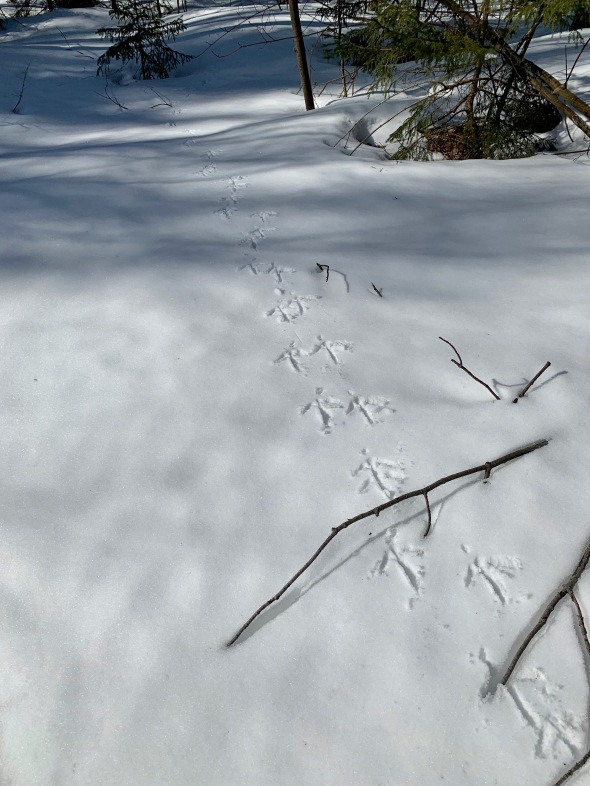
A pair of turkey tracks up at Sleepy Hollow
Morning Observation:
This morning in Huntington at 7:15AM it’s currently 33 degrees and just beginning to snow. Winds are calm. Relative humidity is 95%, dewpoint 32, barometric pressure 29.54” and falling rapidly. We picked up 0.12” of rain overnight and have 7” of snow at the stake. Yesterday’s high was 47, and the overnight low was 33.
There is a Winter Storm Warning in effect for our region until noon on Saturday.
Forecast:
A late season winter storm is on our doorstep this morning as deepening coastal low pressure lifts northeastward through the region today and moves into the Gulf of Maine overnight. Thermal profiles are a bit on the cusp, so snowfall ranges could vary quite a bit, we could see anywhere in the range of 6″-12″ locally with up to 10″-18″ in the northern ‘Dacks and along the spine of the Greens. The storm should taper off quickly Saturday, giving way to partly sunny skies by the afternoon. A mild and sunny day is on tap for Sunday under high pressure. A cold front will sweep through Sunday night bringing some light snow showers and ushering in some chilly Canadian air to start the work week. Temperatures will bounce back to more seasonable levels by midweek.
We’ll see cloudy skies today with rain transitioning to snow. Highs will be near 37 with east winds 6 to 13 mph becoming northerly in the afternoon. Chance of precipitation is 100% with total daytime snow accumulations of 1″-2″ possible. Tonight snow is likely. Lows will be around 24 with blustery northwest winds 14 to 20 mph and gusting to 31 mph. Chance of precipitation is 100% with new snow accumulations of 3″ to 7″ possible.
Saturday should bring snow before 11:00am tapering to lingering snow showers between 11:00am and 2:00pm. Highs will be near 32 with northwest winds around 15 mph. Chance of precipitation is 90% with new snow accumulations of 1″ to 3″ possible. Saturday night should be clear with a low around 22 and southwest winds 6 to 8 mph.
Sunday should start off partly sunny with increasing clouds. Highs will be near 46 with southwest winds around 10 mph. Sunday night should be cloudy with a 40% chance of rain showers before 10:00pm, then a chance of snow showers after midnight. It’ll be mostly cloudy with a low around 23 and northwest winds 3 to 8 mph.
Almanac:
Last year on this date we had a high of 40 and a low of 12. We had 19.5″ of snow at the stake.
Burlington averages for this date are a low of 24 and a high of 42.
The record low was 3 in 1941.
The record high was 81 in 2012 (we had a high of 80).
Sky Notes:
Sunrise: 6:51AM
Sunset: 7:06PM
Length of day: 12:14:40
Today will be 3:04 longer than yesterday.
The Moon is waning gibbous, 16 days old with 97% illumination.
Moonrise: 9:14PM
Moonset: 8:04AM
About Today’s Photo:
I came across this great pair of turkey tracks in fresh snow the other day while skiing at Sleepy Hollow . I can just visualize the pair of big birds strutting along in the snow, one after the other.
iPhone XR

Leave a comment