Sunday, March 10, 2019
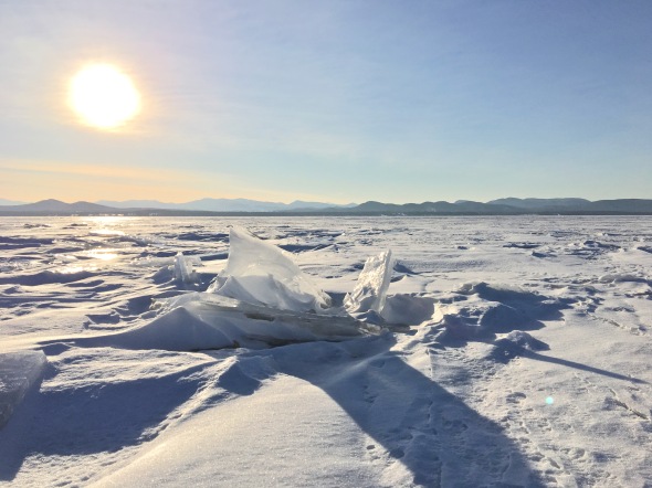
Frozen Lake Champlain yesterday afternoon
Morning Observation:
This morning in Huntington at 8:45AM Eastern Daylight Savings Time, it’s currently 28 degrees and snowing under overcast skies. Winds are our of the east at 8-15mph and gusting to 39 mph. Relative humidity is 92%, dewpoint 23, barometric pressure 30.15” and falling rapidly. We’ve picked up maybe 0.2” of new snow (hard to tell with all the wind) and have 14.5” at the stake. Yesterday’s high was 37, and the overnight low was 27.
There is a Wind Advisory in effect for our region until 5:00PM this evening.
Forecast:
Low pressure moving out of the Great Lakes this morning will make for an exciting day weather-wise. Morning snow should begin to mix with sleet soon before transitioning to plain rain by midday. Snowfall totals will generally range from 1″-3″ with less than 1″ for much of Northern New York and the Champlain Valley. A strong low-level jet overhead is driving gusty winds down to the surface. Gusts in the range of 35 to 50 mph are expected across the western slopes of the Greens and ‘Dacks with 25 to 40 mph gusts elsewhere. Both winds and rain will taper off this evening. Some upslope snow showers is expected Monday with the passage of the upper level trough and accompanying cold front, but there’s not much moisture to work with so snowfall amounts should be limited. High pressure will build in Tuesday bringing dry conditions along with a warming trend. Highs are expected to bump into the low to mid 50s by Friday. The next chance for precipitation arrives Friday in the form of rain.
We’ll see snow this morning before noon, mixing with rain between noon and 3:00pm, then plain rain after 3:00pm. It’ll be cloudy with a high near 40 and southeast winds 26 to 29 mph gusting to 48 mph. Chance of precipitation is 70% with total daytime snow accumulations of around 1″ expected. Tonight will be cloudy with rain showers likely. Lows will be around 30 with southwest winds 11 to 15 mph gusting to 26 mph. Chance of precipitation is 60% with rainfall amounts of less than a 1/10″ expected.
Monday should be mostly cloudy with a 60% chance of rain showers between 11:00am and 5:00pm, mixing with snow in the evening. Highs will be near 39 with west winds 14 to 18 mph gusting to 34 mph. New snow accumulations of less than 1/2″ are expected. Monday night snow showers are likely. It’ll be mostly cloudy with a low around 20 and northwest winds 11 to 14 mph. Chance of precipitation is 60% with new snow accumulations of less than 1″ expected.
Tuesday’s looking partly sunny with a high near 32 and northwest winds around 14 mph. Tuesday night should be partly cloudy with a low around 14 and northwest winds 5 to 7 mph becoming calm after midnight.
Almanac:
Last year on this date we had a high of 33 and a low of 27. We had 10.25″ of snow at the stake.
Burlington averages for this date are a low of 19 and a high of 37.
The record low was -9 in 1984.
The record high was 62 in 2002 (we had a high of 67).
Sky Notes:
Sunrise: 7:13AM
Sunset: 6:51PM
Length of day: 11:37:41
Today will be 3:04 longer than yesterday.
The Moon is a waxing crescent, 3.4 days old with 12.4% illumination.
Moonrise: 9:20AM
Moonset: 10:56PM
About Today’s Photo:
We stopped by the Charlotte Town Beach yesterday afternoon to check out the ice. Lake Champlain was officially declared “frozen over” for the first time since 2015. We walked out onto the ice a few hundred yards. The surface was a jumble of chunks and pressure ridges creating a topography reflecting that of the Adirondacks on the horizon.

Leave a comment