Monday, December 17, 2018
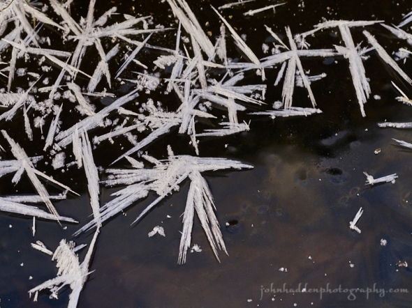
Hoarfrost crystals on ice
Morning Observation:
This morning in Huntington at 7:25AM it’s currently 33 degrees under overcast skies. There’s a hint of precipitation falling. Winds are calm. Relative humidity is 88%, dewpoint 30, barometric pressure 29.70” and falling slowly. We have 4.75” of snow at the stake. Yesterday’s high was 40, and the overnight low was 32.
Forecast:
An upper trough approaching from the northwest will provide the region with scattered to numerous snow showers this afternoon and tonight. Snowfall amounts should range from a dusting to an inch in valley locations, to 1″-3″ around 1000′, and up to 6″ along the spine of the Greens. High pressure will build in Tuesday bringing dry and cool conditions through Thursday. The next chance for precipitation arrives Thursday night as a coastal low brings mixed precipitation Thursday night and rain Friday into Saturday, along with well above normal temperatures.
Today snow is likely after after 5:00PM. It’ll be cloudy with a high near 37 and light and variable winds becoming northwesterly 8 to 13 mph in the afternoon and gusting to 24 mph. Chance of precipitation is 60% with total daytime snow accumulation of less than 1/2″ possible. Tonight snow is likely. Lows will be around 17 with northwest winds around 17 mph gusting to 30 mph. Chance of precipitation is 90% with new snow accumulation of 1″-3″ possible.
Tuesday should bring a 40% chance of snow showers in the morning. It’ll be cloudy with a high near 21 and northwest winds 13 to 16 mph gusting to 28 mph. Tuesday night should be partly cloudy with a low around 10 and northwest winds 5 to 11 mph.
Wednesday’s looking sunny with a high near 33 and calm winds becoming southerly 5 to 7 mph in the afternoon. Wednesday night should be partly cloudy with a low around 22 and south winds 3 to 7 mph.
Almanac:
Last year on this date we had a high of 18 and a low of -4. We picked up 0.30″ of new snow and had 4″ at the stake.
Burlington averages for this date are a low of 18 and a high of 33.
The record low was -11 in 2013 (we had a low of -14).
The record high was 56 in 2000 (we had a high of 54).
Sky Notes:
Sunrise: 7:22AM
Sunset: 4:13PM
Length of day: 8:51:40
Today will be 0:22 shorter than yesterday.
The Moon is waxing gibbous, 9 days old with 68% illumination.
Moonrise: 1:21PM
Moonset: 1:17AM
About Today’s Photo:
This shot is from a few days back when temperatures were cold. Long delicate hoarfrost crystals form on top of ice of Fargo Brook.
Panasonic GX8, Olympus 60mm macro lens, ISO 800m f/8, 1/80″ exposure.

Leave a comment