Saturday, May 4, 2024
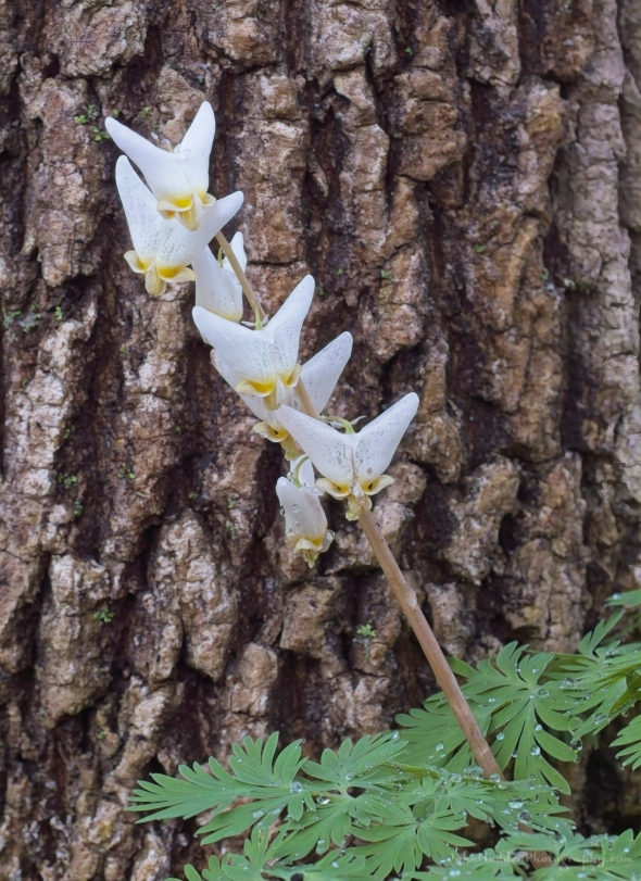 A jaunty set of Dutchman’s breeches
Morning Observation:
This morning in North Hero at 7:20AM it’s currently 55 degrees and sprinkling a bit under cloudy skies. Winds are out of the south at 5-8 mph. Relative humidity is 81%, dewpoint 49, barometric pressure 30.20”. Yesterday’s high was 66, and yesterday’s low was 48. The overnight low got down to 54.
This morning in Huntington it’s currently 57 degrees under cloudy skies. Winds are calm. Relative humidity is 76%, dewpoint 49, barometric pressure 30.24”. Yesterday’s high was 74, and yesterday’s low was 45. The overnight low got down to 51.
Forecast Discussion:
An occluded front is currently moving across Vermont bringing some showers which should wind down by midmorning. Clouds should also begin to erode bringing some glimpses of sunshine as temperatures rise into the 60s to near 70. Cooler Maritime air will advect into the region east of the Greens overnight with overnight lows in the 40s east of the Greens and in the 50s west. A slow-moving cold front is expected to move across the region later tonight into Sunday bringing widespread showers and perhaps a rumble of thunder along with south gusty winds in the Champlain Valley. Showers will persist through Sunday night and wind down by Monday morning as drier air makes it way in behind the departing front. Highs on Monday are expected to be in the mid 60s to low 70s as high pressure builds in. Dry conditions will continue through Tuesday. A more active and showery weather pattern is expected midweek.
3-Day Forecast:
We’ll see mostly cloudy skies today with a high near 67 and south winds 6-8 mph in Huntington and 8-15 over Lake Champlain. Tonight should be mostly cloudy with a low around 46 and south winds 9-15 mph.
Sunday should be cloudy with showers. Highs will be near 54 with south winds 11-14 mph in Huntington and 20-24 mph in the Champlain Valley. Chance of precipitation is 80% with rainfall amounts between 0.25″-0.50″ possible. Sunday night should be cloudy with showers. Lows will be around 49 with south winds 9-13 mph. Chance of precipitation is 80% with rainfall amounts between 0.10″-0.25″ possible.
Monday should start out cloudy with a 30% chance of morning showers. Skies should gradually clear with a high near 68 and south winds 6-8 mph becoming northwesterly in the afternoon. Monday night should be mostly clear with a low around 46 and northwest winds 3-6 mph.
Almanac:
Last year on this date in Huntington we had a high of 50 and a low of 42. We picked up 0.08″ of rain.
Last year in North Hero we had a high of 54 and a low of 45. We picked up 0.02″ of rain.
Burlington averages for this date are a low of 44 and a high of 65.
The record low was 27 in 1961.
The record high was 89 in 1944.
The Lake Champlain lake level in Burlington is 97.88′.
The water temperature is 43˚.
Last year’s lake level was at 98.72′.
The Mt. Mansfield snow stake depth is 38″.
The average depth for this date is 43″.
Mt. Washington Summit Conditions
Current Temperature: 39˚
Winds are out of the NE at 8-10 mph
24 hr Precipitation: 0
Visibility: around 70 miles under partly cloudy skies.
Sky Notes:
Sunrise: 5:37AM
Sunset: 8:00PM
Length of day: 14:22:20
today will be 2:34 longer than yesterday.
The Moon is a waning crescent, 25 days old with 19% illumination.
Moonrise: 3:56AM
Moonset: 3:54PM
About Today’s Photo:
Dutchman’s breeches are prolific this time of year at Pelots Nature Area here in North Hero. This native spring ephemeral has a flower structure dependent and bumblebees for pollination. Good thing as bumbles are just about the only active pollinators this time of year.
Panasonic GX8, Olympus 60mm macro lens, ISO 800, f/8, 1/60″ exposure

Leave a comment